Embed Size (px)
Citation preview

ASX ANNOUNCEMENT ASX: PGO
6 November 2017
Further information to Mount Bundy gold nugget discovery announcement
On 2 November 2017, Primary Gold Limited (ASX: PGO) (“Primary” or “the Company”), released an announcement with respect to the discovery of a number of gold nuggets within the Mount Bundy Gold Project in the Northern Territory. The announcement did not contain a complete JORC Table 1 in accordance with Listing Rule 5.7.
The attached announcement replaces the Company’s 2 November 2017 announcement and also contains further information including a map of where the nuggets were found, the timing of the discovery, and the ownership of the nuggets in accordance with requests made by ASX. The Company notes that whilst the discovery of the nuggets is positive as it is over an underexplored area with no historical drilling, investors are cautioned that such a discovery is considered early stage, is at surface only, and there is no guarantee that further exploration will result in the estimation of a Mineral Resource.
As a result of this announcement investors should disregard the Company’s announcement of 2 November 2017.
The Company confirms it is in compliance with the ASX Listing Rules, in particular, Listing Rule 3.1 and that the Board has approved the release of this announcement.
For more information, please contact: Garry Mills - Managing Director T: +61 8 6143 6700 Or download our Primary Gold App
For
per
sona
l use
onl
y

ASX ANNOUNCEMENT ASX: PGO
6 November 2017
Gold Nuggets Discovered at Mount Bundy Identify New Exploration Target
HIGHLIGHTS
Gold nuggets weighing approximately 40oz discovered within Mount Bundy tenement package Single prospector discovered the nuggets using a metal detector over a six week period Nuggets discovered in under explored region that has had no historical drilling
Figure 1: Gold nuggets recently found at Mount Bundy Project (incl gold bars made from finer gold)
For
per
sona
l use
onl
y

ASX ANNOUNCEMENT ASX: PGO
6 November 2017
Primary Gold Limited (ASX: PGO) (“Primary” or “the Company”) is pleased to advise that a number of gold nuggets have been discovered from within the Mount Bundy Gold Project in the Northern Territory.
These nuggets, with a total weight of approximately 40 ounces (approx. 1134 grams), were discovered by a private prospector not related to the Company over an approximate six week period using a metal detector. The prospector retains ownership of the nuggets.
The gold nuggets were discovered in six separate locations in a broad zone, on ridge lines in an under explored region of the project area (refer Figure 2).
The Company believes the angular shape of the nuggets suggest they were found close to the source as minimal rounding has occurred compared to nuggets that have travelled significant distances and been exposed to physical transport mechanisms.
Figure 2. Location of nuggets found
For
per
sona
l use
onl
y
ASX ANNOUNCEMENT ASX: PGO
6 November 2017
Commenting on the nuggets, Primary Gold Managing Director, Mr Garry Mills said, “This is a significant discovery of nuggets when compared to other well-known gold producing regions in Australia.”
“It is clear from the discovery of these nuggets coupled with historic exploration results and Primary’s own field exploration that the Mount Bundy Project is highly prospective for gold but remains under explored. Apart from Primary’s 2017 initial exploration program, drilling has not occurred in areas outside of the Toms Gully deposit for more than 20 years and the Company has now instigated a systematic exploration program to assess new potential.”
The prospector first provided initial details of the nuggets to the Company’s tenure manager on 1 October 2017. The information provided included a brief summary of what was found and a Mines Department map showing approximate locations of where nuggets were found, but lacked specific coordinates. Primary believed the information provided was substantially incomplete and sought further information from the prospector, including location details and photographic evidence.
This information was provided to Primary employees on 8 October 2017. On receipt of the information Primary sought to independently produce more comprehensive location maps. An initial draft was prepared by an independent contractor on 10 October 2017 and provided to the Company. The Company requested further work be completed with respect to the map and a revised map was received by the Company on 26 October 2017. A draft announcement was then prepared and following reviews and edits by the board released to the ASX on 2 November 2017 (ultimately without a map as the Company was concerned that such disclosure would lead to an increase in illegal prospecting activity on the Company’s tenements).
Whilst the Company had always viewed the discovery of nuggets as positive given the discovery was made in an under explored area of the Mount Bundy Project, in light of similar nugget discovery announcements made by other junior exploration companies with projects in the Pilbara region of Western Australia, the Company formed the view that the discovery of the nuggets was likely to be viewed as material. Nevertheless, the Company was surprised at the market’s reaction to the Company’s 2 November 2017 announcement given a lesser response was received to what the Company considers to be more material and positive announcements released throughout October, such as the completion of a maiden Ore Reserve estimate and completion of a positive pre-feasibility study for the Coolgardie Project (17 October 2017), confirming contractor selection for the Coolgardie Project (among other work for that project in order to achieve commencement of production in Q4 2017, subject to regulatory approvals) (19 October 2017), and the estimation of a revised Mineral Resource estimate for the Mount Bundy Project (which was announced on 31 October 2017 and increased significantly the Mineral Resources at Mount Bundy by 72%). The Company believes the release of the above announcements throughout October, coupled with an increase in marketing efforts, generated renewed investor interest in Primary.
For
per
sona
l use
onl
y
ASX ANNOUNCEMENT ASX: PGO
6 November 2017
Mount Bundy Gold Project
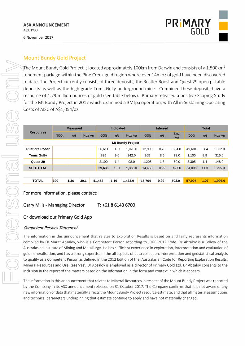
The Mount Bundy Gold Project is located approximately 100km from Darwin and consists of a 1,500km2 tenement package within the Pine Creek gold region where over 14m oz of gold have been discovered to date. The Project currently consists of three deposits, the Rustler Roost and Quest 29 open pittable deposits as well as the high grade Toms Gully underground mine. Combined these deposits have a resource of 1.79 million ounces of gold (see table below). Primary released a positive Scoping Study for the Mt Bundy Project in 2017 which examined a 3Mtpa operation, with All in Sustaining Operating Costs of AISC of A$1,054/oz.
Resources Measured Indicated Inferred Total
‘000t g/t Koz Au ‘000t g/t Koz Au ‘000t g/t Koz Au ‘000t g/t Koz Au
Mt Bundy Project
Rustlers Roost 36,611 0.87 1,028.0 12,990 0.73 304.0 49,601 0.84 1,332.0
Toms Gully 835 9.0 242.0 265 8.5 73.0 1,100 8.9 315.0
Quest 29 2,190 1.4 98.0 1,205 1.3 50.0 3,395 1.4 148.0
SUBTOTAL 39,636 1.07 1,368.0 14,460 0.92 427.0 54,096 1.03 1,795.0
TOTAL 690 1.36 30.1 41,452 1.10 1,463.0 15,764 0.99 503.0 57,907 1.07 1,996.0
For more information, please contact: Garry Mills - Managing Director T: +61 8 6143 6700 Or download our Primary Gold App
Competent Persons Statement
The information in this announcement that relates to Exploration Results is based on and fairly represents information compiled by Dr Marat Abzalov, who is a Competent Person according to JORC 2012 Code. Dr Abzalov is a Fellow of the Australasian Institute of Mining and Metallurgy. He has sufficient experience in exploration, interpretation and evaluation of gold mineralisation, and has a strong expertise in the all aspects of data collection, interpretation and geostatistical analysis to qualify as a Competent Person as defined in the 2012 Edition of the ‘Australasian Code for Reporting Exploration Results, Mineral Resources and Ore Reserves’. Dr Abzalov is employed as a director of Primary Gold Ltd. Dr Abzalov consents to the inclusion in the report of the matters based on the information in the form and context in which it appears.
The information in this announcement that relates to Mineral Resources in respect of the Mount Bundy Project was reported by the Company in its ASX announcement released on 31 October 2017. The Company confirms that it is not aware of any new information or data that materially affects the Mount Bundy Project resource estimate, and that all material assumptions and technical parameters underpinning that estimate continue to apply and have not materially changed.
For
per
sona
l use
onl
y

JORC (2012) TABLE 1 Checklist of Assessment and Reporting Criteria
Section 1 - Sampling Techniques and Data
Criteria of JORC Code
2012
Explanation given in the JORC Code 2012 Details of the Reported Project
(1.1.) Sampling techniques
• Nature and quality of sampling (eg cut channels, random chips, or specific specialized industry standard measurement tools appropriate to the minerals under investigation, such as down hole gamma sondes, or handheld XRF instruments, etc). These examples should not be taken as limiting the broad meaning of sampling.
Hand held metal detector was used for finding the gold nuggets.
The gold search was made by traversing the prospective areas that were elected based on prospector’s interpretation of the geology and regolith
Traversing was made along the lines that were covering the search area by a regular grid.
Distance between lines is unknown
• Include reference to measures taken to ensure sample representivity and the appropriate calibration of any measurement tools or systems used.
For
per
sona
l use
onl
y

• Aspects of the determination of mineralisation that are Material to the Public Report. In cases where ‘industry standard’ work has been done this would be relatively simple (eg ‘reverse circulation drilling was used to obtain 1 m samples from which 3 kg was pulverised to produce a 30 g charge for fire assay’). In other cases more explanation may be required, such as where there is coarse gold that has inherent sampling problems. Unusual commodities or mineralisation types (eg submarine nodules) may warrant disclosure of detailed information.
The gold nuggets were not used as the samples for appraisal of the gold endowment, therefore consideration regarding representivity of the samples are irrelevant for this type of work.
Signal of the metal detector was followed up by a digging using a hand held pick and shovel
Nuggets were found at the depth of approximately a shovel blade
Drilling techniques (1.2.)
• Drill type (eg core, reverse circulation, open-hole hammer, rotary air blast, auger, Bangka, sonic, etc) and details (eg core diameter, triple or standard tube, depth of diamond tails, face-sampling bit or other type, whether core is oriented and if so, by what method, etc).
No drilling has been undertaken
Drill sample recovery (1.3.)
• Method of recording and assessing core and chip sample recoveries and results assessed.
Not applicable. No drilling has been undertaken
• Measures taken to maximise sample recovery and ensure representative nature of the samples.
• Whether a relationship exists between sample recovery and grade and whether sample bias may have occurred due to preferential loss/gain of fine/coarse material.
Logging (1.4.)
• Whether core and chip samples have been geologically and geotechnically logged to a level of detail to support appropriate Mineral Resource estimation, mining studies and metallurgical studies.
Location of the nuggets was recorded by prospectors. Insufficient detail obtained from the prospectors to support a mineral resource estimate. This information was never intended to be used for Resource estimation.
For
per
sona
l use
onl
y
• Whether logging is qualitative or quantitative in nature. Core (or costean, channel, etc) photography.
No geological documentation was used • The total length and percentage of the relevant intersections logged.
Sub-sampling techniques and sample preparation (1.5.)
• If core, whether cut or sawn and whether quarter, half or all core taken
Sub-sampling and quality control techniques are not applicable. Nuggets were not considered to be used as samples.
Location of the nuggets, given their angular shapes, may be indicative of their close location to a source of the nuggets, which are likely to be the gold lodes.
• If non-core, whether riffled, tube sampled, rotary split, etc and whether sampled wet or dry.
• For all sample types, the nature, quality and appropriateness of the sample preparation technique.
• Quality control procedures adopted for all sub-sampling stages to maximise representivity of samples.
• Measures taken to ensure that the sampling is representative of the in situ material collected, including for instance results for field duplicate/second-half sampling.
• Whether sample sizes are appropriate to the grain size of the material being sampled.
Quality of assay data and laboratory tests (1.6.)
• The nature, quality and appropriateness of the assaying and laboratory procedures used and whether the technique is considered partial or total.
No assay data or laboratory tests have been made.
For
per
sona
l use
onl
y

• For geophysical tools, spectrometers, handheld XRF instruments, etc, the parameters used in determining the analysis including instrument make and model, reading times, calibrations factors applied and their derivation, etc.
• Nature of quality control procedures adopted (eg standards, blanks, duplicates, external laboratory checks) and whether acceptable levels of accuracy (ie lack of bias) and precision have been established.
Verification of sampling and assaying (1.7.)
• The verification of significant intersections by either independent or alternative company personnel.
Fossicking for gold by definition is finding and recovering gold from the loose sediments underlaying the top soil. This is not a sampling and therefore the findings cannot be verified by collecting the duplicate samples because all found gold is recovered by prospector.
Assessment of the gold finds is made by prospector who is weighing the recovered gold nuggets on his scales
• The use of twinned holes.
• Documentation of primary data, data entry procedures, data verification, data storage (physical and electronic) protocols.
• Discuss any adjustment to assay data.
Location of data points (1.8.)
• Accuracy and quality of surveys used to locate drill holes (collar and down-hole surveys), trenches, mine workings and other locations used in Mineral Resource estimation.
Location of the areas where the gold nuggets have been found was determined by hand-held GPS by prospectors and have been made available to Primary Gold management
• Specification of the grid system used. MGA (GDA94) zone 52 is used at the project
• Quality and adequacy of topographic control. Not applicable. Gold nuggets have been recovered from surface by shovel For
per
sona
l use
onl
y
Data spacing and distribution (1.9.)
• Data spacing for reporting of Exploration Results.
Type of work completed does not allow to characterise size of the gold lodes representing the possible source of the gold nuggets
The found nuggets are reported here as the Exploration Results because they are indicative of a proximity to a potential source of the bed rock gold
• Whether the data spacing and distribution is sufficient to establish the degree of geological and grade continuity appropriate for the Mineral Resource and Ore Reserve estimation procedure(s) and classifications applied.
• Whether sample compositing has been applied.
Orientation of data in relation to geological structure (1.10.)
• Whether the orientation of sampling achieves unbiased sampling of possible structures and the extent to which this is known, considering the deposit type.
The gold nuggets not used as the samples for appraisal of the gold endowment, therefore consideration regarding orientation of the samples are irrelevant for this type of work.
Objective of the reported gold nuggets finds is to highlight findings of gold in the previously unexplored areas. For this purpose the completed work (fossicking) provides unbiased results
• If the relationship between the drilling orientation and the orientation of key mineralised structures is considered to have introduced a sampling bias, this should be assessed and reported if material.
Not applicable
Sample security (1.11.)
• The measures taken to ensure sample security All recovered gold weighed by prospectors on their scales and then sold to the gold dealer
Audits or reviews (1.12.)
• The results of any audits or reviews of sampling techniques and data.
Nuggets were sold to the gold dealer. No audit or review undertaken by Primary.
For
per
sona
l use
onl
y

Section 2 - Reporting of Exploration Results
Criteria of JORC Code
2012
Explanation given in the JORC Code 2012
Details of the Reported Project
Mineral tenement and land tenure status (2.1)
• Type, reference name/number, location and ownership including agreements or material issues with third parties such as joint ventures, partnerships, overriding royalties, native title interests, historical sites, wilderness or national park and environmental settings.
The metal detecting was completed on the exploration leases EL30824, EL30809 and mining leases, ML1083, ML29783, hold by Primary Gold
For
per
sona
l use
onl
y

• The security of the tenure held at the time of reporting along with any known impediments to obtaining a licence to operate in the area.
Leases are granted and are properly maintained
Exploration done by other parties (2.2)
• Acknowledgment and appraisal of exploration by other parties.
Gold nuggets were found by independent prospectors who have obtained permission from the Primary Gold for fossicking
Geology (2.3) • Deposit type, geological setting and style of mineralisation.
Gold nuggets are related to quartz gold lodes, possibly similar to that found at the Quest 29 deposit where high grade gold lodes were mined
Drill hole Information (2.4)
• A summary of all information material to the understanding of the exploration results including a tabulation of the following information for all Material drill holes:
Not applicable. No drilling was undertaken at the sites where gold nuggets were found.
Expl. Lease
No of blocks
Sq Km Grant Date Expiry Date
EL30809 152 508.90 3-Jul-15 2-Jul-21EL30824 185 619.38 3-Jul-15 02-Jul-21
Mining Lease
No of hectars
Sq Km Grant Date Expiry Date
ML29781 140 1.40 06-Feb-13 05-Feb-23ML29782 80 0.80 06-Feb-13 05-Feb-23ML29783 285 2.85 06-Feb-13 05-Feb-23ML29785 40 0.40 06-Feb-13 05-Feb-23ML29786 112.52 1.13 06-Feb-13 05-Feb-23ML29812 158 1.58 06-Feb-13 05-Feb-23ML29814 84.29 0.84 06-Feb-13 05-Feb-23MLN1058 681.8 6.82 03-Aug-89 02-Aug-39MLN1083 755.6 7.56 04-Mar-91 31-Dec-20
For
per
sona
l use
onl
y
• Easting and Northing of the drill hole collar.
• Elevation or RL (Reduced Level – elevation above sea level in metres) of the drill hole collar.
• dip and azimuth of the hole.
• down hole length and interception depth
• hole length.
• If the exclusion of this information is justified on the basis that the information is not Material and this exclusion does not detract from the understanding of the report, the Competent Person should clearly explain why this is the case.
Data aggregation methods (2.5)
• In reporting Exploration Results, weighting averaging techniques, maximum and/or minimum grade truncations (eg cutting of high grades) and cut-off
All recovered nuggets were combined and weighed. The total weight of the recovered gold is approximately 1134 gram.
For
per
sona
l use
onl
y

grades are usually Material and should be stated.
• Where aggregate intercepts incorporate short lengths of high grade results and longer lengths of low grade results, the procedure used for such aggregation should be stated and some typical examples of such aggregations should be shown in detail.
Not applicable. The gold nuggets not used for determining the grade of the gold mineralisation and not suitable for appraisal of the gold endowment.
Objective of the reported gold nuggets is to highlight findings of gold in the previously unexplored areas. For this purpose the completed work (fossicking) provides unbiased results
• The assumptions used for any reporting of metal equivalent values should be clearly stated.
Not applicable. Approximate total weight of gold is reported.
Relationship between mineralisation widths and intercept lengths (2.6)
• These relationships are particularly important in the reporting of Exploration Results.
The work was limited to recovery of gold by shovels from soil and a loose top layer of regolith. This process doesn’t provide interceptions of the mineralised bodies.
Due to type of work geometry of gold mineralisation (width, thickness and length along strike) is unknown, therefore, no comments can be made regarding relationships of mineralisation geometry and recovered nuggets.
• If the geometry of the mineralisation with respect to the drill hole angle is known, its nature should be reported.
Not applicable. Mineralisation was not delineated by the metal detectors and depth of distribution of the gold nuggets is unknown F
or p
erso
nal u
se o
nly

• If it is not known and only the down hole lengths are reported, there should be a clear statement to this effect (eg ‘down hole length, true width not known’).
Gold nuggets were recovered by shovels therefore true width (and/or true thickness) not known
Diagrams (2.7) • Appropriate maps and sections (with scales) and tabulations of intercepts should be included for any significant discovery being reported These should include, but not be limited to a plan view of drill hole collar locations and appropriate sectional views.
Geological map of Primary Gold’s Mount Bundy project area showing location of the area where the reported gold nuggets were found is reported in the body of this announcement.
The photograph of the nuggets are presented in the announcement.
Balanced reporting (2.8)
• Where comprehensive reporting of all Exploration Results is not practicable, representative reporting of both low and high grades and/or widths should be practiced to avoid misleading reporting of Exploration Results.
Comprehensive reporting of the Exploration Results is not practicable because the objective of the work was fossicking for gold that was sold to the gold dealer.
The gold nuggets were found in the areas that was not systematically explored and lacking of exploration drilling. Finding of the gold nuggets in those areas has an exploration significance indicating for prospectivity of these areas for discovery of the bed-rock gold mineralisation.
Due to type of the work, it is believed that representing the findings as total weight of the recovered gold is the most practical way of reporting the fossicking findings as Exploration Results F
or p
erso
nal u
se o
nly

Other substantive exploration data (2.9)
• Other exploration data, if meaningful and material, should be reported including (but not limited to): geological observations; geophysical survey results; geochemical survey results; bulk samples – size and method of treatment; metallurgical test results; bulk density, groundwater, geotechnical and rock characteristics; potential deleterious or contaminating substances.
No new data available for the areas where gold nuggets were found
Further work (2.10)
• The nature and scale of planned further work (eg tests for lateral extensions or depth extensions or large-scale step-out drilling).
Primary Gold intends to continue exploration of the Mount Bundy project area, including a detailed aeromagnetic survey planned for 2018, which will be followed up by systematic geochemical exploration along the prospective gold-bearing anticlinal structures and the scout drilling of the generated targets.
For
per
sona
l use
onl
y
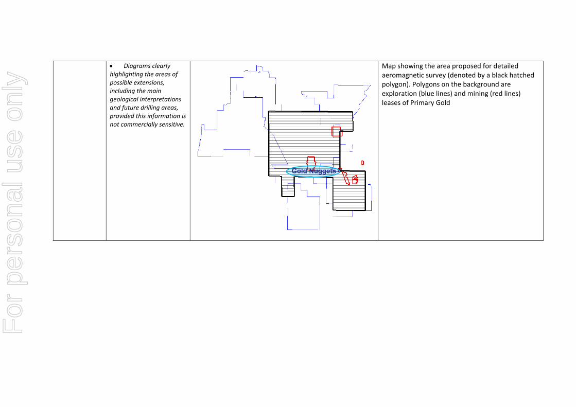
• Diagrams clearly highlighting the areas of possible extensions, including the main geological interpretations and future drilling areas, provided this information is not commercially sensitive.
Map showing the area proposed for detailed aeromagnetic survey (denoted by a black hatched polygon). Polygons on the background are exploration (blue lines) and mining (red lines) leases of Primary Gold
For
per
sona
l use
onl
y