Embed Size (px)
Citation preview

Future Computing and Informatics Journal Future Computing and Informatics Journal
Volume 3 Issue 2 (2018) Vol 3,Issue 2,2018 Article 22
2018
Applying spatial intelligence for decision support systems Applying spatial intelligence for decision support systems
Amira Idrees Faculty of Computers and Information Fayoum University, Fayoum, Egypt, [email protected]
Mohamed H. Ibrahim Faculty of Computers and Information, Fayoum University, Egypt, [email protected]
Follow this and additional works at: https://digitalcommons.aaru.edu.jo/fcij
Part of the Computer Engineering Commons
Recommended Citation Recommended Citation Idrees, Amira and Ibrahim, Mohamed H. (2018) "Applying spatial intelligence for decision support systems," Future Computing and Informatics Journal: Vol. 3 : Iss. 2 , Article 22. Available at: https://digitalcommons.aaru.edu.jo/fcij/vol3/iss2/22
This Article is brought to you for free and open access by Arab Journals Platform. It has been accepted for inclusion in Future Computing and Informatics Journal by an authorized editor. The journal is hosted on Digital Commons, an Elsevier platform. For more information, please contact [email protected], [email protected], [email protected].
Applying spatial intelligence for decision support systems
Amira M. Idrees a, Mohamed H. Ibrahim a,*, Ahmed I. El Seddawy b
a Faculty of Computers and Information, Fayoum University, Egyptb Department of Information Systems, Faculty of Business Administration, Arab Academy for Science Technology & Maritime Transport (AASTMT), Cairo, Egypt
Received 2 November 2018; revised 3 November 2018; accepted 5 November 2018
Available online 10 November 2018
Abstract
Data mining is one of the vital techniques that could be applied in different fields such as medical, educational and industrial fields.Extracting patterns from spatial data is very useful to be used for discovering the trends in the data. However, analyzing spatial data is exhaustivedue to its details as it is related to locations with a special representation such as longitude and latitude. This paper aims at proposing an approachfor applying data mining techniques over spatial data to find trends in the data for decision support. Basic information considering spatial data ispresented with presenting the proposed approach aiming to be applied in the Egyptian organizations to prove its applicability.Copyright © 2018 Faculty of Computers and Information Technology, Future University in Egypt. Production and hosting by Elsevier B.V. Thisis an open access article under the CC BY-NC-ND license (http://creativecommons.org/licenses/by-nc-nd/4.0/).
Keywords: Data mining techniques; Spatial OLAP; Spatial data warehouse; GIS
1. Introduction
Geographic Information Systems (GIS) can be defined asthe information systems that process spatial data. GIS is able toproduce different types of trends in spatial data represented inmaps with various quality levels. This variation usually allowsthe user to find useful relations among the discovered trends[7]. Users could gain numerous benefits from applying GIS byreaching the useful information about different locations andthe relations among these locations which is a result ofanalyzing image data that is represented in maps. Spatial datais presented in different layers (as shown in Fig. 1) forming themap such as the buildings, entities and their boundaries [7].
The remaining structure of the paper is as follows: Section2 discusses the main definitions that are related to spatial dataand business intelligence and the relation between both para-digms. Then Section 3 focusses on the main approaches for
applying data mining overs spatial data. Moreover, Section 4demonstrates the related work while Section 5 presents theproposed approach for integrating spatial data with differentsources for developing spatial intelligence for enhancing thefindings of the decision support systems. Finally, Section 6provides the experimental case study discussion and theconclusion is presented in Section 7.
2. Background
This section discusses the main definitions that are relatedto spatial data and business intelligence and the relation be-tween both paradigms.
2.1. Vector and Raster data
Spatial data can be classified into Vector and Raster data.The following aspects provide a simple definition for bothclassifications.
Vector data provides representation to the places and entitiesas either dots or lines as well as polygons. On one hand, the dotprovides the exactmap place for the entity, the line represents the
* Corresponding author.
E-mail address: [email protected] (M.H. Ibrahim).
Peer review under responsibility of Faculty of Computers and Information
Technology, Future University in Egypt.
Available online at www.sciencedirect.com
ScienceDirect
Future Computing and Informatics Journal 3 (2018) 384e390http://www.journals.elsevier.com/future-computing-and-informatics-journal/
https://doi.org/10.1016/j.fcij.2018.11.001
2314-7288/Copyright © 2018 Faculty of Computers and Information Technology, Future University in Egypt. Production and hosting by Elsevier B.V. This is an
open access article under the CC BY-NC-ND license (http://creativecommons.org/licenses/by-nc-nd/4.0/).
Idrees and Ibrahim: Applying spatial intelligence for decision support systems
Published by Arab Journals Platform, 2018

relation between these entities and the polygon represents morecomplex relations. On the other hand, raster data divides themapinto adjacent cells which provide a storage capability to each celltargeting to store all details in the map as shown in Fig. 2. Theseinformation can be stored with linking to its corresponding partsuch as the height as shown in Fig. 2. The extracted informationis useful for finding patterns among the map components such asmedical users as depicted in Fig. 2.
2.2. Spatial data in business intelligence
Data warehouse is the main repository that is essential forBusiness Intelligence (BI) solutions. Therefore, developing aspatial data warehouse can provide a further step in BI byapplying spatial data analysis for supporting business intelli-gence. OLAP is one of the most common techniques thatcould be applied on different types of repositories whichconsequently could lead to adopt decision support systems.OLAP that is based on spatial data provides a concreterecognition for the useful information in different fields such
as medical and educational fields [5]. Moreover, providingresults to the OLAP query should depends on both spatial dataand other types of data for fully reliable results. Additionally,although data mining is traditionally applied in data re-positories has also been targeting to provide the useful trendsin GIS data.
According to the research by Ref. [4]; building datawarehouses over GIS data has been emerged with differentresearchers such as in, consequently, developing efficientqueries through cube relations among spatial data can thenprovide the required decision support as depicted in Fig. 3.
The cube for spatial data includes many dimensions andmeasures that match geometry features. These features usuallyrepresent the entities defining the members of the field. Spatialdimensions are then integrated with the ordinary type of di-mensions for providing different levels of analysis. However,spatial dimensions may depend on both vector data fordiscrete source and raster data for continuous source. Theanalysis is then applied according to the provided type. Fig. 4presents the different classes of spatial data representing thedimensions in the data warehouses.
Many different measures as well as Extract, Transform, andLoad (ETL) techniques could also represent spatial data withthe same concept. For instance, ETL provides different ag-gregations on spatial data. This situation leads to an essentialprocess to ensure the applicability, consistency and reliabilityof the spatial data to be in use. This leads to different issuessuch as the spatial data integration for decision support. Thedefined spatial boundaries should be also determined. Thisobviously clarifies the complexity in building spatial datawarehouses. Therefore, one of the most challenging points isto apply the traditional BI techniques over the GIS data.Although these difficulties may hinder the required investi-gation, however, using cartographic sources may provide aclear identification and contribute in the solution.
Fig. 1. Layers for spatial data.
Source: Ref. [1].
Fig. 2. An example for spatial medical map.
385A.M. Idrees et al. / Future Computing and Informatics Journal 3 (2018) 384e390
Future Computing and Informatics Journal, Vol. 3 [2018], Iss. 2, Art. 22
https://digitalcommons.aaru.edu.jo/fcij/vol3/iss2/22

3. Spatial data mining
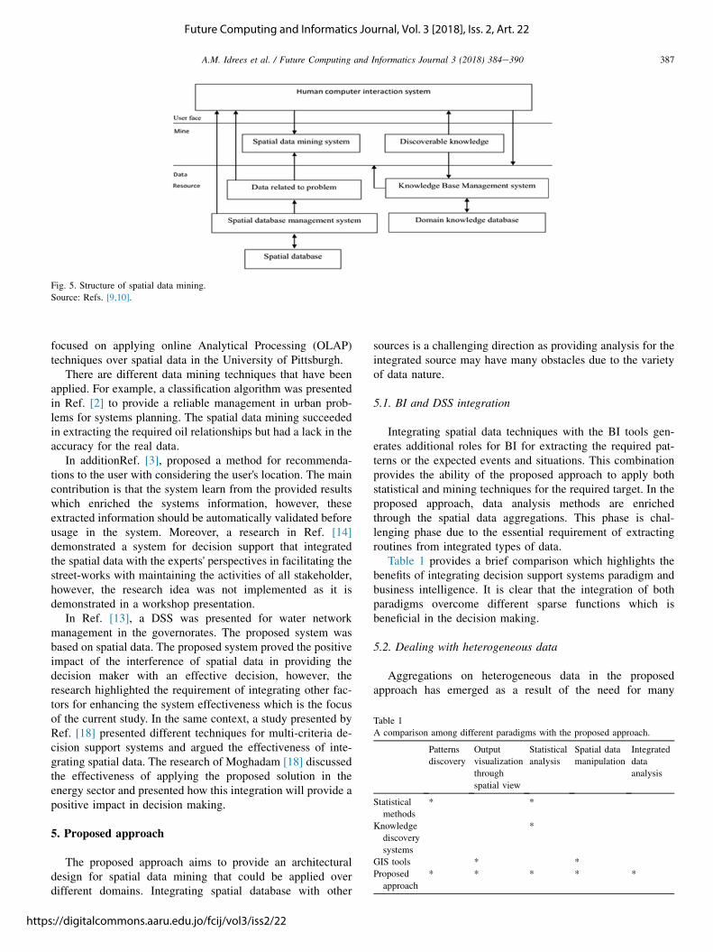
Earlier researchers have investigated applying the datamining techniques over the spatial data. Different targets wereon focus such as remote sensing or customers' support.Recently, different architectures are proposed from differentpoints of views such as in Refs. [9,10] as shown in Fig. 5.
Focusing on data mining tasks and techniques, segmentationprovides a classification for all entities according to criteriadefined by the decision maker. Dependency analysis is able topredict the classes in the repository. Deviation and analysis areresponsible for classification input data into two main classesclustering and classification. The first class determines anddescribes relationships between data items. The second dis-covers rules in order to allocate data items to existing classes.Deviation and outlier analysis can classify the user as good or
malicious users. Finally trend decision provides the mostsuitable result according to the discovered trends.
According to Ref. [15]; analyzing spatial data for findingthe relations and monitoring the spatial behavior is a coreproblem in spatial data mining. Different algorithms are pro-posed for this direction to extract different types of relationssuch as k-means, constraint-based, and Bayesian for clus-tering, FP-Growth for associations, Genetic algorithms, andNaïve Bayes for classifications.
4. Literature review
Some applications are presented by different researchers,for example, a research by Harnandez and his colleagues [11]applied GIS in the medical field for monitoring the diseasedirection, while another study by ML and her colleagues [16]
Fig. 3. Feature-based and raster-based spatial cubes.
Source: Ref. [4].
Fig. 4. Spatial data cubes with different examples of spatial dimensions.
Source: Ref. [4].
386 A.M. Idrees et al. / Future Computing and Informatics Journal 3 (2018) 384e390
Idrees and Ibrahim: Applying spatial intelligence for decision support systems
Published by Arab Journals Platform, 2018
focused on applying online Analytical Processing (OLAP)techniques over spatial data in the University of Pittsburgh.
There are different data mining techniques that have beenapplied. For example, a classification algorithm was presentedin Ref. [2] to provide a reliable management in urban prob-lems for systems planning. The spatial data mining succeededin extracting the required oil relationships but had a lack in theaccuracy for the real data.
In additionRef. [3], proposed a method for recommenda-tions to the user with considering the user's location. The maincontribution is that the system learn from the provided resultswhich enriched the systems information, however, theseextracted information should be automatically validated beforeusage in the system. Moreover, a research in Ref. [14]demonstrated a system for decision support that integratedthe spatial data with the experts' perspectives in facilitating thestreet-works with maintaining the activities of all stakeholder,however, the research idea was not implemented as it isdemonstrated in a workshop presentation.
In Ref. [13], a DSS was presented for water networkmanagement in the governorates. The proposed system wasbased on spatial data. The proposed system proved the positiveimpact of the interference of spatial data in providing thedecision maker with an effective decision, however, theresearch highlighted the requirement of integrating other fac-tors for enhancing the system effectiveness which is the focusof the current study. In the same context, a study presented byRef. [18] presented different techniques for multi-criteria de-cision support systems and argued the effectiveness of inte-grating spatial data. The research of Moghadam [18] discussedthe effectiveness of applying the proposed solution in theenergy sector and presented how this integration will provide apositive impact in decision making.
5. Proposed approach
The proposed approach aims to provide an architecturaldesign for spatial data mining that could be applied overdifferent domains. Integrating spatial database with other
sources is a challenging direction as providing analysis for theintegrated source may have many obstacles due to the varietyof data nature.
5.1. BI and DSS integration
Integrating spatial data techniques with the BI tools gen-erates additional roles for BI for extracting the required pat-terns or the expected events and situations. This combinationprovides the ability of the proposed approach to apply bothstatistical and mining techniques for the required target. In theproposed approach, data analysis methods are enrichedthrough the spatial data aggregations. This phase is chal-lenging phase due to the essential requirement of extractingroutines from integrated types of data.
Table 1 provides a brief comparison which highlights thebenefits of integrating decision support systems paradigm andbusiness intelligence. It is clear that the integration of bothparadigms overcome different sparse functions which isbeneficial in the decision making.
5.2. Dealing with heterogeneous data
Aggregations on heterogeneous data in the proposedapproach has emerged as a result of the need for many
Fig. 5. Structure of spatial data mining.
Source: Refs. [9,10].
Table 1
A comparison among different paradigms with the proposed approach.
Patterns
discovery
Output
visualization
through
spatial view
Statistical
analysis
Spatial data
manipulation
Integrated
data
analysis
Statistical
methods
* *
Knowledge
discovery
systems
*
GIS tools * *
Proposed
approach
* * * * *
387A.M. Idrees et al. / Future Computing and Informatics Journal 3 (2018) 384e390
Future Computing and Informatics Journal, Vol. 3 [2018], Iss. 2, Art. 22
https://digitalcommons.aaru.edu.jo/fcij/vol3/iss2/22

functions' requirements in different fields. For example, thediscovery of a disorder such as brain tumor can be a chal-lenging task in the data mining field [6]. The high dimen-sionality of the data in addition to the requirements of differenttype of data such as rays, statistics, reports and analysis toreach a concrete decision. These types should be all taken intoconsideration as each type of this data contributes in theanalysis result. Including spatial data type raise the chal-lenging in the data heterogeneity analysis in the data miningtasks as it requires specific methods for pre-processing dataincluding filtering and managing inconsistency, to data man-agement, and finally the output visualization. The proposedapproach integrates the different data sources into unifiedsubject-oriented structure aiming to enrich the mining task tobe able to provide efficient analysis with the required data foraccurate results.
5.3. The architectural model for the proposed approach
The proposed approach targets to support the decisionmakers with a wide view of the current situation from differentperspectives due to the different data nature. Applying busi-ness intelligence tools over the spatial data warehouse is alsoone of the main targets that should be considered whichconsequently provide concrete and accurate decision support.Fig. 6 presents the proposed approach for mining spatial data.The proposed approach aims at adopting BI solutions to beable to be applied over the spatial data warehouse in order tofind trends in business. The main contribution in the proposedapproach is the possibility of integrating the other sources withspatial data for better decision support recommendations.Fig. 6 illustrates the main architecture of the proposedapproach.
The proposed methodology of the research maintain thequalitative approach which is performed by analyzing thecurrent situation and provides the related work of this researchrepresented in the previous proposed approaches of earlierresearches. According to the different previous researches,although integrating different types of data is not a recent
research point, however, it has been found that few researchershave considered including spatial data as one of these typesdue to the diversity in the data nature. Moreover, integratingbusiness intelligence solutions for a system with spatial data isalso challenging as BI depends mainly on numeric data whichhighlights the essential integration requirement in the pro-posed approach.
This research aims to provide a general approach for de-cision support which is based on different types of dataincluding spatial data. Therefore, the following research planis generalized while it can be applied in different domains withidentifying the general phases according to the domain nature.The research plan is identified in the following phases:
Phase one considers identifying the main focus in the fieldwith gathering the required data, this phase is very critical asthe gathered data is considered the main pillar for the successof the proposed methodology. Phase two considers developingthe spatial database, integrating the data sources, and buildingthe spatial data warehouse. Phase three focuses on selectingthe required data mining model while phase four focuses ondefining the dimensions and measures, identifying the keyperformance indicators, then selecting the analysis tool forspatial data. Phase five targets provide recommendationsthrough different views such as reports and domain map fordecision support.
Fig. 6. Structure of the proposed approach for applying spatial data mining.
Table 2
Sample of the numerical-text data (ESRI) (2012e2013).
Object ID County Disease rate
1 Baltimore City 236.9
2 Washington 202.5
3 Wicomico 254.6
4 Somerset 294.4
5 Queen Anne's 168.7
6 St. Mary's 167.8
7 Montgomery 110.7
8 Prince George's 172.5
9 Kent 150.9
10 Howard 125.2
Source: Ref. [7].
Fig. 7. Map distribution of heart disease (ESRI).
Source: Ref. [7].
388 A.M. Idrees et al. / Future Computing and Informatics Journal 3 (2018) 384e390
Idrees and Ibrahim: Applying spatial intelligence for decision support systems
Published by Arab Journals Platform, 2018

6. Experimental case study
The components of the proposed approach were appliedthrough the suitable tools for each phase. The case study wasapplied on a benchmark dataset [7] targeting to prove theapplicability of the proposed approach. Spatial data andnumerical-textual data were downloaded for Heart DiseaseMortality rate in Maryland. The main aim of the case studywas to demonstrate a clarified map for the heart disease whichprovides the expected trend of the disease. KPIs were suc-cessfully identified which provided comprehensive reports forthe disease distribution. Table 2 provides a sample of the datawhich includes the disease distribution over the territories withdemonstrating the distribution in the map. More resources arethen provided which included the total population, age dis-tribution, and residential level with respect to the year (Fig. 7).
Reports are divide the given set to have both training andtesting Data, the main aim was to generate reports that arematching with the expected output. The system succeeded topredict the disease distribution in 2015 with 85% of accuracy.Fig. 8 presents the distribution of 2012e2015 which clarifiesthat the distribution of 2014 reached 14% of the total deathrate and 15% in 2015 was an increase of 1% which leaves anerror rate with the predicted percentage with 15%. However, itis clear that a requirement of more experiments with largerdimensionality would prove the applicability of the proposedapproach.
7. Conclusion
While mining heterogeneous data is a challenging field,however, it could provide effective solutions for differentsectors. Moreover, including spatial data in the dataset in-creases the challenge that the approach could face. This paperpresented an overview for different algorithms and approacheswhich are applied on spatial data with demonstrating the is-sues faced in the field. The paper also proposed an approachthat can be applied for spatial data mining in different fieldssuch as medical, educational, and other fields. The mainchallenges that this research focused on is as follows: inte-grating spatial data with other data sources, dealing withheterogeneous data in all phases of the proposed approach, and
visualizing the results in an interactive method. The proposedapproach has been evaluated through a benchmark dataset ofheart disease mortality, and succeeded in predicting the mor-tality rate with an accuracy of 85%. The error percentage wasdue to the minor dimensions of the attributes which could beovercome with using real dataset. As the proposed approachwas applied using supportive tools, therefore, future work cantarget to build an application with a user interface. Moreover,more experiments should be applied in different fields withhigher dimensionality of the dataset.
References
[1] Idrees Amira M, Khaled Mostafa Lamlom Ahmed, Talkhan Amal Hassan
Ali. Spatial data mining, spatial data warehousing, and spatial OLAP.
Emerging Trends in Open Source Geographic Information Systems. IGI
Global. 2018.
[2] Cai Y, Wang X, Hu K, Dong M. A data mining approach to finding re-
lationships between reservoir properties and oil production for CHOPS.
Comput Geosci 2014;73.
[3] Bao J, Zheng Y, Wilkie D, Mokbel MF. A survey on recommendations in
location-based social networks. GeoInformatica 2012;212.
[4] B�edard Y, Merrett T, Han J. Fundamentals of spatial data warehousing
for geographic knowledge discovery. Geographic data mining and
knowledge discovery. Taylor & Francis; 2001. p. 53e73. Vol. ResearchMonographs in GIS, No. Chap. 3.
[5] Bimonte S, Pinet F, Miralles A, Papajorgji P. Spatial data warehouses and
SOLAP. GeoInformatica 2014;18:269e72.
[6] Cao Bokai, Kong Xiangnan, Yu Philip S. A review of heterogeneous data
mining for brain disorder identification. Brain Inform 2015;2:253e64.
[7] ESRI; 2018. Retrieved from: http://support.esri.com/en/knowledgebase/
GISDictionary/.
[9] Hemalatha M, Naga Saranya N. A recent survey on knowledge discovery
in spatial data. IJCSI Int J Comput Sci Iss 2011;8(3):2.
[10] Jassar KK, Dhindsa KS. Comparative study of spatial data mining
technique. Int J Comput Appl 2015;112:14.
[11] Harnandez Jaime, Nunez Ignacia, Bacigalupo Antonella, Pedro E, Cat-
tan. Modeling spatial distribution of Chagas disease vectors using envi-
ronmental variables and people's knowledge. Int J Health Geogr 2013;31:12e29.
[13] Jayarathnaa Lasinidu, Darshana Rajapaksa b, Shunsuke Managi b,c,
Wasantha Athukorala d, Benno Torgler c, Maria A, et al. A GIS based
spatial decision support system for analysing residential water demand: a
case study in Australia. Sustain Cities Society 2017;32:67e77.
[14] Wei Lijun, Clarke Barry, Magee Derek R, Dimitrova Vania,
Cohn Anthony G. An integrated web-based decision support system for
inter-asset streetworks management. In: 26th GIScience research UK
conference (GISRUK); 2018. Leicester, UK.
Fig. 8. Distribution of heart disease mortality (2011e2015).
389A.M. Idrees et al. / Future Computing and Informatics Journal 3 (2018) 384e390
Future Computing and Informatics Journal, Vol. 3 [2018], Iss. 2, Art. 22
https://digitalcommons.aaru.edu.jo/fcij/vol3/iss2/22

[15] Martin Ester H-p K. “Algorithms and applications for spatial data min-
ing”, invited chapter for geographic data mining and knowledge dis-
covery. Research Monographs in GIS. Taylor and Francis; 2001.
[16] Miranda ML, Casper M, Tootoo J, Schieb L. Putting chronic disease on
the map: building GIS capacity in state and local health departments.
Previous Chronic Disease, vol. 10. Centers for Disease Control and
Prevention; 2013.
[18] Moghadam Sara Torabi, Delmastro Chiara, Lombardi Patrizia,
Stefano P, Corganti. Towards a new integrated spatial decision
support system in urban context. In: 2nd International Symposium
“New Metropolitan Perspectives” e strategic planning, spatial
planning, economic programs and decision support tools, through the
implementation of Horizon/Europe 2020, ISTH2020, Reggio Cala-
bria, Italy, 18e20 May 2016; 2016.
390 A.M. Idrees et al. / Future Computing and Informatics Journal 3 (2018) 384e390
Idrees and Ibrahim: Applying spatial intelligence for decision support systems
Published by Arab Journals Platform, 2018


![Computing Informatics L 10 16[1]](https://img.pdfslide.net/doc/110x75/577cd0831a28ab9e789274e1/computing-informatics-l-10-161.jpg)