Embed Size (px)
Citation preview
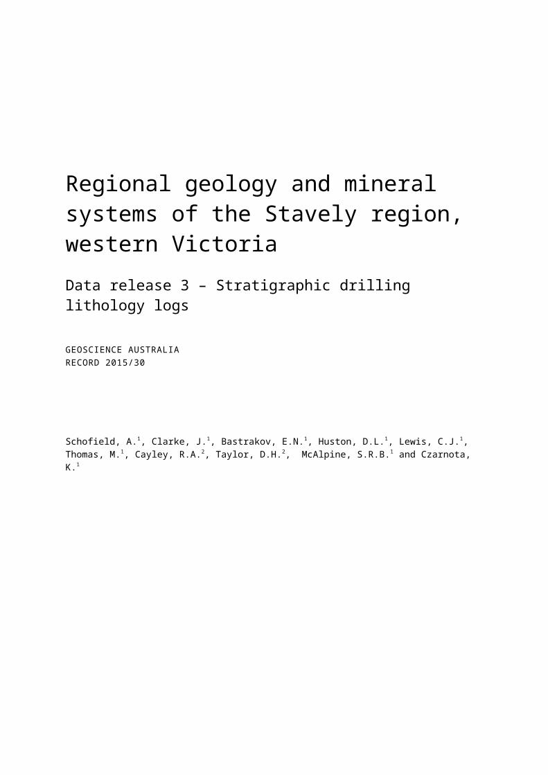
Regional geology and mineral systems of the Stavely region, western VictoriaData release 3 – Stratigraphic drilling lithology logs
GEOSCIENCE AUSTRALIARECORD 2015/30
Schofield, A.1, Clarke, J.1, Bastrakov, E.N.1, Huston, D.L.1, Lewis, C.J.1, Thomas, M.1, Cayley, R.A.2, Taylor, D.H.2, McAlpine, S.R.B.1 and Czarnota, K.1
1. Geoscience Australia2. Geological Survey of Victoria

Department of Industry, Innovation and ScienceMinister for Resources, Energy and Northern Australia: The Hon Josh Frydenberg MPAssistant Minister for Science: The Hon Karen Andrews MPSecretary: Ms Glenys Beauchamp PSM
Geoscience AustraliaChief Executive Officer: Dr Chris Pigram
Department of Economic Development, Jobs, Transport and ResourcesMinister for Energy and Resources: Hon. Lily D'Ambrosio MPSecretary: Mr Richard BoltExecutive Director Earth Resources Policy and Programs: Mr Anthony Hurst
Geological Survey of VictoriaDirector: Mr Paul McDonald
This paper is published with the permission of the CEO, Geoscience Australia and the Director, Geological Survey of Victoria.
© Commonwealth of Australia (Geoscience Australia) and State Government of Victoria (Geological Survey of Victoria) 2015
With the exception of the Commonwealth Coat of Arms and where otherwise noted, this product is provided under a Creative Commons Attribution 4.0 International Licence. (http://creativecommons.org/licenses/by/4.0/legalcode)
Geoscience Australia has tried to make the information in this product as accurate as possible. However, it does not guarantee that the information is totally accurate or complete. Therefore, you should not solely rely on this information when making a commercial decision.
Geoscience Australia is committed to providing web accessible content wherever possible. If you are having difficulties with accessing this document please email [email protected].
ISSN 2201-702X (PDF)
ISBN 978-1-925124-92-7 (PDF)
GeoCat 87840
Bibliographic reference: Schofield, A., Clarke, J., Bastrakov, E.N., Huston, D.L., Lewis, C.J., Thomas, M., Cayley, R.A., Taylor, D.H., McAlpine, S.R.B. and Czarnota, K. 2015. Regional geology and mineral systems of the Stavely region, western Victoria: Data release 3 – Stratigraphic drilling lithology logs. Record 2015/30. Geoscience Australia, Canberra. http://dx.doi.org/10.11636/Record.2015.030

Contents
Executive summary................................................................................................................................ iv
1 Introduction.......................................................................................................................................... 11.1 Project Background........................................................................................................................ 11.2 Geography..................................................................................................................................... 21.3 Mineral exploration in the Stavely region........................................................................................21.4 The Stavely Project........................................................................................................................ 3
2 Geological overview............................................................................................................................. 8
3 Overview of pre-competitive stratigraphic drilling in the Stavely Project area....................................113.1 Drilling objectives......................................................................................................................... 113.2 Drill hole rationale and aims.........................................................................................................16
3.2.1 STAVELY01............................................................................................................................ 163.2.2 STAVELY02............................................................................................................................ 163.2.3 STAVELY03............................................................................................................................ 163.2.4 STAVELY04............................................................................................................................ 163.2.5 STAVELY05............................................................................................................................ 163.2.6 STAVELY06............................................................................................................................ 173.2.7 STAVELY07............................................................................................................................ 173.2.8 STAVELY08............................................................................................................................ 173.2.9 STAVELY09............................................................................................................................ 173.2.10 STAVELY10.......................................................................................................................... 183.2.11 STAVELY11.......................................................................................................................... 183.2.12 STAVELY12.......................................................................................................................... 183.2.13 STAVELY13.......................................................................................................................... 183.2.14 STAVELY14.......................................................................................................................... 183.2.15 STAVELY15.......................................................................................................................... 183.2.16 STAVELY16.......................................................................................................................... 193.2.17 STAVELY17.......................................................................................................................... 193.2.18 STAVELY18.......................................................................................................................... 193.2.19 STAVELY19.......................................................................................................................... 19
3.3 Drilling techniques........................................................................................................................19
4 Data release 3 – stratigraphic drilling lithology logs...........................................................................204.1 Previous Stavely Project releases................................................................................................204.2 Lithological logging procedures....................................................................................................20
4.2.1 Sonic drill core logs................................................................................................................. 204.2.2 Diamond drill core logs...........................................................................................................21
5 Data included in this release..............................................................................................................22
Acknowledgements............................................................................................................................... 23
References........................................................................................................................................... 24
Regional geology and mineral systems of the Stavely region, western Victoria. Data release 3 iii

Executive summary
The Stavely Project is a collaboration between Geoscience Australia and the Geological Survey of Victoria. During 2014 fourteen pre-competitive stratigraphic drill holes were completed in the prospective Stavely region in western Victoria in order to better understand subsurface geology and its potential for a variety of mineral systems. The Stavely region hosts several belts of poorly-exposed Cambrian volcanic and intrusive rocks, visible largely only in aeromagnetic data, which have similarities to those found in modern subduction-related tectonic settings. Mineralisation associated with porphyry Cu-Au and volcanic-hosted massive sulphide mineral systems is known where these rocks are exposed around Mount Stavely and the Black Range. However, despite a history of mineral exploration dating back to the late 1960s, significant economic deposits are yet to be discovered, and the Stavely region remains a greenfields terrane. Given the geological setting and known mineral potential, opportunity exists for the discovery of large mineral systems beneath extensive, but relatively thin, younger cover.
The Stavely Project aims to provide the framework for discovery in the Stavely region primarily through the acquisition and delivery of pre-competitive geoscientific data. This includes the completion of pre-competitive stratigraphic drill holes in order to test regional geological interpretations and recover material for detailed lithological, petrophysical, geochemical and geochronological analysis. The results will assist in understanding the mineral systems potential of the Stavely region under cover.
This report describes the logging methods and procedures used to produce lithology logs for stratigraphic drill holes completed as part of the Stavely Project. Data presented in this release include summary and detailed geological logs, logging metadata, and graphic geological logs. Also included are reports on biostratigraphic and palynological age constraints of unconsolidated drill core, and on volcanic facies observed in the volcanic rocks intersected during drilling.
iv Regional geology and mineral systems of the Stavely region, western Victoria. Data release 3

1 Introduction
1.1 Project BackgroundSporadic historical mineral exploration from the 1960s to the 1990s within and around exposed portions of Cambrian volcanic rocks in the Stavely region of western Victoria resulted in the identification of Cu, Au and base metal mineralisation (e.g. Seymon et al., 2009). More recent research undertaken by universities and government has suggested that some of the Cambrian volcanic rocks are fault-slices of a large, mostly-buried continental margin magmatic arc system – the Stavely Arc1. The Stavely Arc is named after the Mount Stavely Belt, which hosts Cambrian igneous rocks of arc affinities and includes the Mount Stavely Volcanic Complex (Crawford and Keays, 1978; Buckland, 1987). The Cambrian volcanic and intrusive rocks of the Stavely Arc have potential to host world-class magmatic-hydrothermal ore deposits. The aim of the Stavely Project is to further encourage and support efficient mineral exploration of the Stavely Arc, by better delineating its distribution and internal geological variation, and characterising mineralisation styles and context.
Crawford and Keays (1978) were the first to describe the Cambrian igneous rocks exposed in western Victoria as having a calc-alkaline character, with the mineralogy and geochemistry of the rocks at Mount Stavely, in particular, suggestive of formation in a magmatic arc-style tectonic setting. Since then several workers have drawn comparisons between the exposed Cambrian volcanic rocks of western Victoria and the Mount Read Volcanics of western Tasmania, the latter of which hosts world class volcanic-hosted massive sulphide (VHMS) deposits (Crawford et al., 1996; Crawford et al., 2003). A range of tectonic settings for the origin of the igneous rocks in western Victoria have been proposed, each with implications for regional metallogeny.
In 2009, the Geological Survey of Victoria (GSV), in collaboration with Geoscience Australia (GA) and AuScope, designed and acquired regional-scale deep crustal seismic reflection transects across western Victoria. The project results supported the interpretation of the Cambrian igneous rocks exposed around Mount Stavely, in the Black Range, and in several belts buried beneath younger sedimentary rocks, as fault slices of the Stavely Arc, which developed above a west-dipping convergent continental margin during the Cambrian. Seismic reflection data imaged an apparent arc edifice remaining largely intact beneath the Stavely region, the upper parts of which have been thrust to the surface.
The setting was interpreted to have the potential to host significant base metal and precious metal deposits, including porphyry and related mineral systems. In addition, it was recognised that the apparent strike extent of individual volcanic belts continues to the north of known occurrences and that historic mineral exploration had not adequately tested the volcanic rocks under cover. In 2011, the Willaura Project was established by the GSV to evaluate the Cu potential of the southern extent of the Grampians-Stavely Zone in the vicinity of exposed Mount Stavely Volcanic Complex rocks (Cayley et al., in prep. a). In 2013, GA and the GSV initiated the Stavely Project in order to evaluate the mineral potential of the new search space identified below younger cover throughout the Stavely region and build and expand on the key findings of the Willaura Project.
1 The Stavely Arc now replaces the informal and preliminary term ‘Miga Arc’. This term is now abandoned.
Regional geology and mineral systems of the Stavely region, western Victoria. Data release 3 1

The Stavely Project area comprises approximately 20 000 km2 (Figure 1.1). It includes at least eight volcanic belts and the Dimboola Igneous Complex, which extends north from Horsham beyond the project area into far north-west Victoria (Figure 1.2). The volcanic belts are separated by wider regions of deformed Cambrian and Ordovician to Silurian sedimentary rocks, intruded by Cambrian and Devonian intrusive rocks, and are also buried by cover rocks of variable thicknesses. The cover rocks include Mesozoic-Cenozoic fill of the Murray and Otway basins and Cenozoic lavas of the Newer Volcanic Group. While a combination of existing exposure, regional geophysics, historical open file drilling, and deep seismic reflection transects has allowed the broad delineation of these volcanic belts under younger cover, the buried parts of the Stavely Arc remain largely untested for their mineral systems potential.
1.2 GeographyThe Stavely Project area is located in western Victoria, south-eastern Australia, approximately 230-300 km west and northwest of Melbourne (Figure 1.1). The regional centres of Hamilton and Horsham are located in the south and within the centre of the project area, respectively (Figure 1.3). The project area has generally very low relief, with the only exceptions being the Grampians Ranges and Mount Arapiles, which rise above the plains and effectively mark the western end of the Great Dividing Range. North of the divide, the Wimmera River flows past the Grampians National Park and through Horsham towards Lake Hindmarsh. South of the divide, the Glenelg River flows from its origins within the Grampians Ranges, toward the Southern Ocean. In the south of the project area, the Hopkins River flows through Wickliffe and Chatsworth towards the ocean. Many streams in the region are ephemeral and are often dry for long periods. Dryland farming (crops and livestock) comprise large portions of the project area. The Little Desert and Wyperfeld national parks border the project area to the north.
1.3 Mineral exploration in the Stavely region
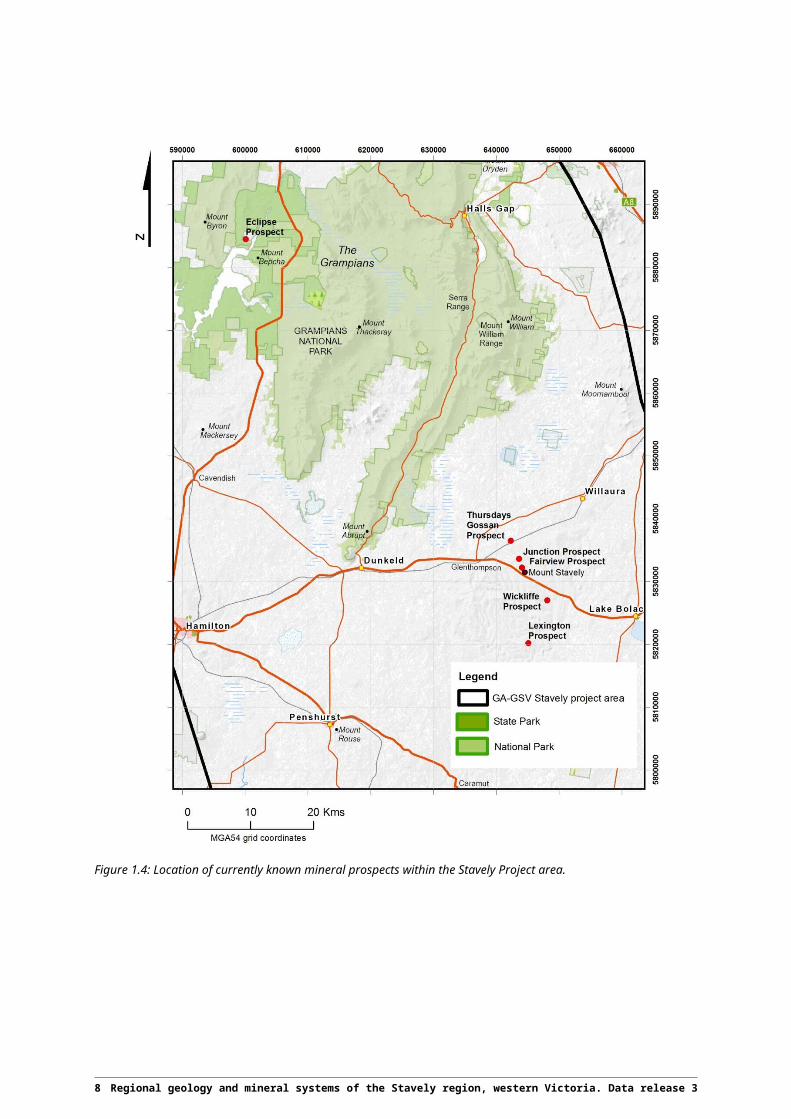
Mineral exploration around the exposed belts of Cambrian volcanic rocks began in 1969 when Western Mining Corporation Limited commenced stream sediment and soil geochemical sampling (e.g. Clappison, 1972). Continued exploration by Duval Mining Limited (formerly Pennzoil) followed up on some of the weak geochemical anomalies in 1975, and had quick success with the discovery of gossanous float containing elevated Cu. Follow-up diamond drilling of anomalies within the Mount Stavely Belt discovered stringer chalcopyrite mineralisation in tuffs, now known as the Wickliffe Prospect (Figure 1.4). Diamond drill hole WICKLIFFE NO. 6 terminated in hydrothermally-altered quartz porphyry, tentatively correlated with the intrusive Lalkaldarno Porphyry (Ramsay, 1983). Soil geochemistry, geophysics, shallow rotary and deeper diamond drilling was successful in identifying additional mineralised quartz-feldspar porphyries at Junction and Thursdays Gossan (Roberts, 1982; Buckland, 1987; Figure 1.4). Further mineral exploration by subsequent companies in the 1990s discovered several additional occurrences of VHMS and porphyry-style mineralisation, including a Cambrian diorite (now referred to as the Lexington Prospect) outside of the Mount Stavely Belt (Figure 1.4).
Northeast of Balmoral, minor placer and hard-rock Au was first discovered in the late nineteenth century, associated with poorly-exposed igneous rocks exposed in valleys which have been eroded through overlying sedimentary rocks of the Grampians Group. These igneous rocks are now included within the Black Range Belt (Figure 1.2). Exploration in the region began in earnest in the late 1960s and several Au and base metal prospects were discovered aligned along the length of the volcanic belt. The most promising prospect identified was the McRaes Prospect (now referred to as the Eclipse Prospect; Figure 1.4) where anomalous Au, Zn, Pb, Cu and Ag is associated with hydrothermally-altered mafic to intermediate volcanic rocks.
2 Regional geology and mineral systems of the Stavely region, western Victoria. Data release 3

A case history study in the late 1990s (Rajagopalan, 1999) detailed Cu-Mo-Au porphyry mineralisation at Mount Stavely and argued that deep weathering had compromised some of the early geochemical exploration and that only the shallow levels of the system had been tested. Although supergene chalcocite mineralisation had been defined at prospects such as Thursdays Gossan, shallow drilling campaigns targeting geochemical anomalies had often failed to penetrate leached in situ regolith and consequently yielded ambiguous results. Limited investigation of the underlying hypogene mineralisation occurred with most drill holes terminating in variable Cu mineralisation associated with hydrothermal alteration. Due to remaining uncertainty over the geological context, exploration of the mineralised systems at depth was not undertaken.
Recent reinterpretation of historic diamond drill core from the early exploration campaigns in the Mount Stavely Belt suggests that porphyry intersections represent dykes that have intruded into the host volcanic rocks, and that large porphyry bodies of potential economic interest may exist at depth and remain untested (Taylor et al., 2014). A similar problem also exists in the Black Range Belt. Here, insufficient drill testing of known mineralisation, as well as geological uncertainty and the presence of barren Silurian-age Grampians Group cover, has impeded mineral exploration across much of the region.
1.4 The Stavely ProjectDespite a relatively long history of mineral exploration in the exposed portions of the Cambrian volcanic rocks, the Stavely region remains a greenfields terrane with the opportunity for significant mineral discoveries, especially below younger cover. The Stavely Project was established in order to provide the fundamental framework for the evaluation and discovery of mineral systems in the Stavely region using a mineral systems-based approach. The Stavely Project is a collaborative program between GA and the GSV and forms part of the broader UNCOVER Initiative (Australian Academy of Science, 2012) and the National Mineral Exploration Strategy (COAG, 2012), which seeks to address the challenges of greenfield mineral exploration in areas of Australia under younger cover.
The Stavely Project aims to provide the framework for exploration risk reduction and discovery in the Stavely region through four key objectives:
1. Characterise subsurface geology and recognise favourable geological environments where major mineral systems may have been active;
2. Identify key elements that demonstrate mineral systems potential;
3. Understand the depth and nature of cover; and
4. Deliver new pre-competitive data and concepts for industry, presenting the evidence for mineral systems potential in greenfields areas under cover.
In addition to the compilation and review of historical geoscientific data for the region, the objectives outlined above were addressed through the acquisition of pre-competitive data, including the completion of a stratigraphic drilling program to test regional geological interpretations and recover samples for lithological, petrophysical, geochemical and geochronological analyses. Site-specific geophysical data acquisition tested the thickness and geophysical properties of cover at selected drill sites (Meixner et al., in prep.). The results of the stratigraphic drilling program will help to better define the margins of the Grampians-Stavely Zone and give further insight into the context, origin and timing of regional mineral systems and aid in future exploration targeting.
Regional geology and mineral systems of the Stavely region, western Victoria. Data release 3 3

Figure 1.1: Location of the Stavely region and structural geological zones of Victoria. Figure adapted from VandenBerg et al. (2000).
4 Regional geology and mineral systems of the Stavely region, western Victoria. Data release 3

Figure 1.2: Known and interpreted volcanic belts of the Stavely Arc. The image is a partially-transparent histogram-equalised pseudocolour layer of the tilt-angle total magnetic intensity (TMI) reduced to the pole (RTP), overlain on a 3-30 km band pass filtered, histogram-equalised pseudocolour layer of TMI (RTP). Blue colours indicate lower magnetic intensity and phase angle values; red colours indicate higher magnetic intensity and phase angle values.
Regional geology and mineral systems of the Stavely region, western Victoria. Data release 3 5

Figure 1.3: Location of the Stavely Project area and significant geographical features.
6 Regional geology and mineral systems of the Stavely region, western Victoria. Data release 3

Figure 1.4: Location of currently known mineral prospects within the Stavely Project area.
Regional geology and mineral systems of the Stavely region, western Victoria. Data release 3 7

2 Geological overview
The Grampians-Stavely Zone (Figure 1.1) lies at the eastern edge of the Cambrian Delamerian Orogen in western Victoria (VandenBerg et al., 2000; Crawford et al., 2003), with the adjacent Stawell Zone forming a complex hybrid transition to the Lachlan Orogen further east (Miller et al., 2005; Cayley et al., 2011; Cayley et al., in prep. b). The interpreted Stavely Arc within the Grampians-Stavely Zone outcrops as a number of narrow north-trending belts of mafic to felsic igneous rocks at Mount Stavely, Mount Dryden, Mount Elliot, and in the Black Range region (Figure 1.2). These were first described during reconnaissance geological mapping of western Victoria in the nineteenth century (Krause, 1873). The belts of igneous rocks are separated by terrigenous deep marine low-grade sedimentary rocks of the Glenthompson Sandstone (Nargoon Group; VandenBerg et al., 2000). A key characteristic of the Cambrian rocks within the Grampians-Stavely Zone is their low (prehnite-pumpellyite facies) metamorphic grade. This contrasts markedly with amphibolite facies metamorphic rocks in the adjacent Glenelg (Gray et al., 2002; Morand et al., 2003) and Stawell (Cayley and Taylor, 2001; Phillips et al., 2002) zones, which lie either side of the region (Figure 1.1).
Early assignment of a Cambrian age for the igneous rocks exposed at Mount Stavely and in the Black Range region was based on comparison with similar rocks in central Victoria from which Cambrian fossils had been recovered (Thomas, 1939). Subsequently, geochronology (Bucher, 1998; Stuart-Smith and Black, 1999; Whelan et al., 2007; Lewis et al., 2015) has confirmed Cambrian ages ranging from 510 Ma to 500 Ma for parts of the Mount Stavely Volcanic Complex. The other volcanic belts in the region currently remain undated.
In the south of the Stavely Project area, the Stavely Arc comprises five individual, relatively narrow (3-8 km) north-northwest-trending volcanic belts (Figure 1.2), which from east to west have been termed the Mount Dryden (190 km strike length), Mount Elliot (25 km strike length), Mount Stavely (80 km strike length), Bunnugal (65 km strike length), and Boonawah (105 km strike length) belts. The Mount Dryden and Mount Stavely belts are directly linked by an oblique series of sub-parallel west- to northwest-trending, faulted volcanic belts, including the Mount Elliot Belt. The Mount Stavely and Bunnugal belts also converge north of Glenthompson. These volcanic belt linkages suggest formation in a contiguous volcanic arc.
Recent mapping by the GSV has identified a swarm of mafic sills intruding into the Glenthompson Sandstone west of the Mount Stavely Belt. These sills may also represent part of the Stavely Arc package. In addition, scattered occurrences of tholeiitic to boninitic lavas also occur throughout the Grampians-Stavely Zone. These may represent igneous rocks related to the ~600 Ma breakup of Rodinia or the later (~520-500 Ma) convergence and deformation associated with the Delamerian Orogeny (Münker and Crawford, 2000; Miller et al., 2005). Rare ultramafic rocks consisting of serpentinised peridotite (e.g. Williamsons Road Serpentinite) also occur in narrow fault slices amongst the other rock packages.
The Stavely Arc, underlying rocks, and overlying Nargoon Group sediments were folded, faulted, and locally tilted to sub-vertical attitudes at around 500 Ma during the Delamerian Orogeny (Crawford et al., 2003). The timing of deformation is constrained by large, post-tectonic, sub-circular intrusions of the Cambrian Bushy Creek Igneous Complex (489 ± 7 Ma; Stuart-Smith and Black, 1999), which intrude deformed Glenthompson Sandstone and truncate the mafic sills west of Mount Stavely
8 Regional geology and mineral systems of the Stavely region, western Victoria. Data release 3

(Crawford et al., 2003). A number of dacitic porphyries (both barren and mineralised) are known near Mount Stavely and occur both within and external to the volcanic belts (Skladzien et al., 2015). Recent studies suggest that the mineralised porphyry intrusions may share some geochemical affinities with parts of the Bushy Creek Igneous Complex and hence may be associated with the latest pulses of magmatism in the Stavely Arc (Taylor et al., 2014). Recent dating of the mineralised, informally named Victor Porphyry, within the Mount Stavely Belt, yielded an igneous crystallisation age of approximately 500 Ma (Lewis et al., 2015).
The volcanic belts of the Black Range area lie to the north of the Grampians, including, from east to west, the Glenisla, Black Range and Tyar belts (Figure 1.2). These are typically 2-3 km in width and 18-30 km in strike length. These belts converge in the south beneath a region covered by Early Devonian volcanic rocks (Rocklands Volcanic Group), and are intruded by post-tectonic granite (likely Devonian in age). Further north of the Grampians a highly magnetic package of igneous rocks of unresolved affinity lies entirely under younger cover, including rocks assigned to the Dimboola Igneous Complex (VandenBerg et al., 2000; Crawford et al., 2003; Figure 1.2).
Regional-scale deep seismic reflection data suggest that the Stavely Arc rocks exposed in the Mount Stavely Belt and in the Black Range region overlie a crest of a crustal-scale, triangular-shaped region of variably reflective crust (Cayley et al., in prep. b). This is interpreted to be the buried, but largely intact, remnants of the Stavely Arc, developed on older rocks related to the rifted east Gondwana margin. The volcanics exposed at Mount Stavely, in the Black Range, and at Mount Dryden are all interpreted to be thrust slices of the underlying Stavely Arc system (Cayley et al., in prep. b).
The outcropping Mount Stavely Volcanic Complex in the Mount Stavely Belt (Figure 1.2) comprises interbedded subaqueous tuffaceous and volcaniclastic rocks, and as a whole is interpreted to be overlain by deep marine turbiditic rocks of the Glenthompson Sandstone (Buckland, 1987). The association of the Mount Stavely Volcanic Complex with deep marine sedimentary rocks led to the interpretation of a post-collisional rift sequence erupted subsequent to an arc-continent collision event, akin to the Mount Read Volcanics of western Tasmania (e.g. Crawford, 1988; VandenBerg et al., 2000; Crawford et al., 2003). Other early interpretations of the overall tectonic setting of the Mount Stavely Volcanic Complex envisaged a Gondwanaland continental margin setting (Crawford, 1982). This hypothesis has recently found support in subsequent geochemical (e.g. Kemp, 2003), geochronological (Foden et al., 2006), and crustal geometry (paired metamorphic belts; Miller et al., 2005) studies.
These results led Foden et al. (2006) to question earlier arc-continent collisional models advocated for the Stavely Arc. Foden et al. (2006) instead suggested a west-dipping continent-directed subduction zone. Geophysical (seismic and magnetotelluric) data presented by Cayley et al. (2011; in prep. b) and Robertson et al. (2015) also argue for a convergent continental arc setting above a west-dipping subducting slab. A variant on this interpretation was proposed by Gibson et al. (2011) who argued for initial east-dipping subduction, intra-oceanic arc accretion, and a subsequent flip in subduction polarity resulting in emplacement of the Stavely Arc above a west-dipping continental margin.
The Cambrian rocks are overlain by the Late Ordovician- to Silurian-aged, fluvial to shallow marine siliciclastic rocks of the Grampians Group (Cayley and Taylor, 1997; Miller et al., 2001; Cayley et al., 2011). In some places the contact is unconformable, but in most places the contact is faulted and or sheared, and the Grampians Group sequence contains significant structural complexity in its own right (Cayley and Taylor, 1997; Miller et al., 2001). Although this group is thickest and most structurally complex close to the eastern edge of the Grampians-Stavely Zone, overall the Grampians Group is much thinner than previously assumed, especially in the regions surrounding the main mountain
Regional geology and mineral systems of the Stavely region, western Victoria. Data release 3 9
ranges (Cayley and Taylor, 1997). Silurian deformation associated with the overlying Grampians Group has affected the underlying Cambrian rocks in places (Cayley and Taylor, 1997, 2001; Morand et al., 2003), and has resulted in the truncation, offset and reorientation of fault slices of the Stavely Arc. Using Grampians Group deformation history as a template, the underlying Cambrian rocks can be undeformed to show a simpler pre-Silurian configuration, including restoration of the now fragmented porphyry and alteration systems contained within the volcanic belts.
The Grampians Group and its Cambrian basement are intruded by numerous Late Silurian to Early Devonian felsic intrusives, including the Dwyer Granite, Mirranatwa Granite, Bullawin Porphyry, Mafeking Suite and Duchembegarra Granite (e.g. see VandenBerg et al., 2000). These are comagmatic with the Rocklands Volcanic Group (Simpson, 1997) which lies to the west of the Grampians Ranges.
Since the Devonian, the Grampians-Stavely Zone has remained one of the most tectonically stable parts of Australia (Foster and Gleadow, 1992). The Stavely Arc was buried beneath Nargoon Group sediments in the Cambrian and subsequently by Grampians Group, and has since experienced relatively minimal uplift and erosion. This accounts for the relatively high, upper-crustal level of preservation of much of the Cambrian geological system. It is likewise expected that related mineral systems will also remain preserved.
Today, the Cambrian bedrock of the Grampians-Stavely Zone is poorly exposed. Key areas of outcrop are at Mount Stavely, as a string of isolated hills near Mount Dryden, in the vicinity of Mount Elliot and Yarram Park, and as poor outcrops in the Black Range region west of the Grampians. The main Grampians Ranges and National Park overlies the centre of these outcrops. Further south, aeromagnetic and gravity data allow the Cambrian bedrock and its intermittent veneer of Grampians Group to be traced beneath thin basalt lava flows of the Newer Volcanic Group, and beneath the Otway Basin.
To the north, geophysical and historical drill hole data allow the Cambrian bedrock to be traced north beneath the Murray Basin. The Murray Basin is a Cretaceous to Recent intracratonic sag basin that hosts world-class heavy mineral sand deposits (Olshina and van Kann, 2012), and gradually attains thicknesses of several hundred metres (McLean, 2010). The extremely gentle dip of the Murray Basin means that over 200 km strike-length of the Cambrian bedrock of the Grampians-Stavely Zone lies within 200-300 m of the present-day surface and could be explored using modern mineral exploration techniques.
10 Regional geology and mineral systems of the Stavely region, western Victoria. Data release 3

3 Overview of pre-competitive stratigraphic drilling in the Stavely Project area
Pre-competitive stratigraphic drill holes are a key component to building an understanding of the geology and mineral systems potential of the Stavely region. Fourteen pre-competitive stratigraphic drill holes, for a total of 2708.5 m, were completed in order to test regional geological interpretations, determine the depth and nature of cover, and to recover material for subsequent detailed analysis.
3.1 Drilling objectivesThe scientific objectives for the holes drilled as part of the Stavely Project are summarised under five key categories (along with the names of specific drill holes):
1. Test the under cover extent of the Mount Stavely Belt, its stratigraphic facing, and its relationship with overlying sedimentary units (STAVELY02 and STAVELY17);
2. Test the presence of interpreted arc-related rocks under cover to define the eastern margin of the Stavely Arc (STAVELY01 and STAVELY16);
3. Test regional structural interpretations to define the western margin of the Stavely Arc (STAVELY05 and STAVELY08);
4. Test for the presence of rocks belonging to the Stavely Arc which have been imaged by magnetic data and determine their character and stratigraphic affinity (STAVELY01, STAVELY02, STAVELY04, STAVELY07, STAVELY11, STAVELY14), as well as target different levels of stratigraphic exposure in the package of north-northwest-trending magnetic rocks previously interpreted as the Dimboola Igneous Complex (STAVELY09, STAVELY10, STAVELY12, STAVELY16); and
5. Characterise the nature of geophysical responses in interpreted arc rocks to test for alteration-related demagnetisation (STAVELY06).
A summary for each drill hole is provided in Table 3.1 and additional information on drill hole rationale and aims is given below. The locations of the pre-competitive stratigraphic drill holes are provided in Figure 3.5 and Figure 3.6.
Regional geology and mineral systems of the Stavely region, western Victoria. Data release 3 11

Table 3.1: Drill hole collar locations, drilling aims, and basement lithology intersected for drill holes completed as part of the Stavely Project.
Hole ID Drilling type Latitude (GDA94)
Longitude (GDA94) Target Total depth (m) Basement lithology
(generalised)
STAVELY01 Diamond -38.018 142.878 Possible Mount Stavely Volcanic Complex or Mount Dryden Volcanics equivalent.
249.5 Amphibolite
STAVELY02 Diamond -37.902 142.712 Extension of the Mount Stavely Belt beneath Grampians Group cover. 159.5 Mafic volcanics (overlain by
Grampians Group)
STAVELY03 Hole cancelled
-37.462 142.186 Demagnetised zone within an otherwise magnetic belt of interpreted Cambrian volcanic rocks.
Hole cancelled Hole cancelled
STAVELY04 Sonic, diamond
-37.164 142.251 Magnetic package of rocks interpreted as Cambrian volcanic rocks. 102.8 Mafic volcanics
STAVELY05 Sonic, diamond
-37.097 142.016 Test for the presence of high-grade metamorphic rocks of the Glenelg Zone to validate structural interpretations.
71.5 Sandstone and siltstone
STAVELY06 Sonic, diamond
-37.050 142.274 Demagnetised zone within an interpreted intrusive rock. 117.7 Quartz diorite
STAVELY07 Sonic, diamond
-36.994 142.323 Magnetic package of rocks interpreted as Cambrian volcanic rocks. Extended to depth to serve as a paleoclimate monitoring bore for the University of Melbourne.
501.6 Intermediate to felsic volcanics
STAVELY08 Sonic, diamond
-36.910 141.670 Test for the presence of high-grade metamorphic rocks of the Glenelg Zone to validate structural interpretations.
122.0 Foliated biotite granite
STAVELY09 Sonic, diamond
-36.800 142.159 Magnetic package of rocks interpreted as Cambrian volcanic rocks and to test the lower stratigraphic levels of a north-northwest-trending package of rocks previously interpreted as Dimboola Igneous Complex.
165.6 Mafic volcanics and quartz gabbro
STAVELY10 Sonic, diamond
-36.804 142.130 Magnetic package of rocks interpreted as Cambrian volcanic rocks and to test the lowest stratigraphic level of a north-northwest-trending package of rocks previously interpreted as Dimboola Igneous Complex.
107.4 Serpentinite
STAVELY11 Sonic, diamond
-36.767 141.967 Test a weak linear magnetic feature for the presence of a northern extension to the Black Range Belt.
164.6 Sandstone and siltstone
STAVELY12 Sonic, diamond
-36.709 142.153 Magnetic package of rocks interpreted as Cambrian volcanic rocks and to test the upper stratigraphic levels of a north-northwest-trending package of rocks previously interpreted as Dimboola Igneous Complex.
180.5 Intermediate volcanics and volcaniclastics
12 Regional geology and mineral systems of the Stavely region, western Victoria. Data release 3

Hole ID Drilling type Latitude (GDA94)
Longitude (GDA94) Target Total depth (m) Basement lithology
(generalised)
STAVELY13 Hole cancelled
-36.424 141.845 Test an elongate magnetic feature to determine its character and stratigraphic affinity.
Hole cancelled Hole cancelled
STAVELY14 Sonic, diamond
-36.437 141.655 Test a gravity feature for the presence of Cambrian volcanic rocks. 339.0 Sandstone and siltstone
STAVELY15 Hole cancelled
-36.771 141.970 Magnetic package of rocks interpreted as Cambrian volcanic rocks and to test the upper stratigraphic levels of a north-northwest-trending package of rocks previously interpreted as Dimboola Igneous Complex.
Hole cancelled Hole cancelled
STAVELY16 Sonic, diamond
-36.265 141.921 Magnetic package of rocks interpreted as Cambrian volcanic rocks and to test the upper stratigraphic levels of a north-northwest-trending package of rocks previously interpreted as Dimboola Igneous Complex.
357.7 Polymictic volcanic breccia
STAVELY17 Diamond -37.683 142.641 Intersect the contact between the Glenthompson Sandstone and the Mount Stavely Volcanic Complex in the Mount Stavely Belt to determine nature of contact and stratigraphic facing.
156.0 Sandstone and siltstone
STAVELY18 Hole cancelled
-37.684 142.652 Intersect the contact between the Glenthompson Sandstone and the Mount Stavely Volcanic Complex in the Mount Stavely Belt to determine nature of contact and stratigraphic facing.
Hole cancelled Hole cancelled
STAVELY19 Hole cancelled
-37.642 142.656 Locate fresh volcaniclastic Glenthompson Sandstone equivalent at-depth for geochronological and geochemical analysis.
Hole cancelled Hole cancelled
Regional geology and mineral systems of the Stavely region, western Victoria. Data release 3 13
Figure 3.5: Location of drill holes drilled as part of the Stavely Project shown on a background of reduced to pole total magnetic intensity, where red is high and blue is low.
14 Regional geology and mineral systems of the Stavely region, western Victoria. Data release 3

Figure 3.6: Location of drill holes drilled as part of the Stavely Project shown on a background of Bouguer anomaly gravity image where red is high and blue is low.
Regional geology and mineral systems of the Stavely region, western Victoria. Data release 3 15

3.2 Drill hole rationale and aims
3.2.1 STAVELY01
STAVELY01, which was drilled approximately 10 km northwest of Mortlake, was the southernmost hole drilled during the program (Figure 3.5 and Figure 3.6). The drill hole targeted a poorly-defined magnetic and gravity anomaly beneath Newer Volcanic Group basalts with the aim of testing for the presence of Cambrian rocks of the Mount Stavely Volcanic Complex or Mount Dryden Volcanics, interpreted to have been offset by Silurian strike-slip faulting. STAVELY01 was collared close to the interpreted location of the Moyston Fault (the eastern boundary of the Grampians-Stavely Zone), to test the eastern limit of the zone and, hence, the Stavely Arc. The drill hole had the secondary objective of testing the depth and nature of cover, particularly with respect to the thickness of the Newer Volcanic Group.
3.2.2 STAVELY02
STAVELY02 was drilled to test the character of a north-trending linear magnetic and gravity feature interpreted to be an extension of the exposed Mount Stavely Belt buried beneath younger sedimentary cover (Figure 3.5 and Figure 3.6). Exposures of sandstone and conglomerate of the Grampians Group occur in a small creek in close proximity to the STAVELY02 collar. Therefore, the drill hole also had the objective of determining the depth of Grampians Group cover above potentially prospective Cambrian basement.
3.2.3 STAVELY03
STAVELY03 (not shown on Figure 3.5 and Figure 3.6) was planned to be drilled approximately 15 km northeast of Cavendish near the southwestern limit of the Victoria Range. The drill hole was intended to target a non-magnetic zone within an otherwise magnetic belt of interpreted Cambrian igneous rocks to test for possible porphyry-related hydrothermal alteration. STAVELY03 was cancelled following detailed gravity data acquisition which failed to show evidence for a gravity low required for the presence of an intermediate to felsic intrusive.
3.2.4 STAVELY04
STAVELY04 targeted a package of magnetic rocks interpreted to be Cambrian mafic to intermediate volcanic rocks in order to determine their character and stratigraphic affinity. The package targeted by STAVELY04 lies just east of the Glenisla Belt (Figure 1.2), which hosts basaltic to andesitic lavas and volcanic breccias (Cayley and Taylor, 1997).
3.2.5 STAVELY05
STAVELY05, located just west of the Black Range, was drilled to test structural models arising from interpretation of the 09GA-SD1 seismic line and regional structural interpretations. The collar location was selected based on its interpreted stratigraphic position. STAVELY05 lies along strike from the northern limit of the Tyar Belt (Figure 1.2), which has been terminated by the younger (Silurian to Devonian) Henty Fault. The drill hole was designed to test the hypothesis that the Henty Fault has offset the western margin of the Grampians-Stavely Zone (Yarramyljup Fault) to the east, which would
16 Regional geology and mineral systems of the Stavely region, western Victoria. Data release 3

result in high-grade metamorphic rocks of the Glenelg River Metamorphic Complex (Glenelg Zone) being intersected, rather than low-grade rocks of the Nargoon Group (Grampians-Stavely Zone). The position of the Yarramyljup Fault defines the western margin of the Grampians-Stavely Zone, and hence the potential extent of the Stavely Arc.
3.2.6 STAVELY06
A buried package of magnetic rocks, interpreted to represent components of the Stavely Arc, occurs in the vicinity of the STAVELY06 collar (Figure 3.5). Hosted within this belt are small ovoid magnetic bodies interpreted as intermediate to felsic intrusive igneous rocks based on geophysical interpretation and previous exploration drilling. Several of these bodies possess non-magnetic cores, potentially indicating destruction of magnetite through hydrothermal alteration. STAVELY06 was drilled to target one such body in order to test the proposed hydrothermal origin of the non-magnetic zone. This has implications for potential targeting of mineralised alteration systems within the Stavely Arc.
3.2.7 STAVELY07
STAVELY07 was drilled to test the character and stratigraphic affinity of a northwest-trending package of sheared and fault-displaced magnetic rocks occurring beneath shallow Murray Basin cover (Figure 3.5). The original target depth for STAVELY07 was ≤100 m. However, a 406 m extension to the hole (for a total depth of 501.6 m) was drilled by the University of Melbourne for the purpose of establishing a permanent subsurface paleoclimate monitoring bore.
3.2.8 STAVELY08
STAVELY08 was the westernmost hole drilled during the program. The primary aim of the drill hole was to test regional structural interpretations. A largely non-magnetic package in the vicinity of STAVELY08 (Figure 3.5) is interpreted to represent a part of the Glenelg River Metamorphic Complex (Glenelg Zone) offset to the east by Silurian strike-slip faulting. If correct, this would result in high-grade metamorphic rocks of the Glenelg River Metamorphic Complex (Glenelg Zone) being intersected by STAVELY08, rather than low-grade rocks of the Nargoon Group (Grampians-Stavely Zone), with implications for the western extent of the Grampians-Stavely Zone and the Stavely Arc. The drill hole also targeted a broadly linear magnetic feature, potentially representing a fault slice of ultramafic to intermediate igneous rocks.
3.2.9 STAVELY09
STAVELY09 was drilled into a prominent package of north-northwest-trending magnetic rocks previously interpreted as the Dimboola Igneous Complex in order to test the character and stratigraphic affinity of the rocks at depth (Figure 3.5). This magnetic package has an overall easterly dip based on regional magnetics and seismic data. STAVELY09 is one of a series of four drill holes (together with STAVELY10, STAVELY12 and STAVELY16) designed to test different stratigraphic levels within this package.
Regional geology and mineral systems of the Stavely region, western Victoria. Data release 3 17

3.2.10 STAVELY10
Similar to STAVELY09, STAVELY10 was drilled to test the character and stratigraphic affinity of a magnetic package of rocks previously interpreted as part of the Dimboola Igneous Complex (Figure 3.5). The drill hole targeted an intense linear magnetic anomaly located in the westernmost limit of this package which is interpreted to represent its deepest stratigraphic level.
3.2.11 STAVELY11
STAVELY11 was drilled approximately four kilometres south of the town of Natimuk in order to test a weak northwest-trending linear magnetic anomaly located beneath Murray Basin cover (Figure 3.5). This feature occurs along strike from known outcrops of intermediate volcanic rocks in the Black Range, and it was anticipated that similar rocks may be encountered in STAVELY11 either as a fault slice or as a dyke-like body intruding deformed non-magnetic sediments of the Nargoon Group.
3.2.12 STAVELY12
STAVELY12 was drilled just west of Horsham to test the character of the easternmost edge of a north-northwest-trending belt of magnetic rocks also targeted by STAVELY09, STAVELY10 and STAVELY16 (Figure 3.5). Together with STAVELY16, this hole was designed to test the shallowest stratigraphic level within this package.
3.2.13 STAVELY13
STAVELY13 (not shown on Figure 3.5 and Figure 3.6), approximately 6.5 km south of Gerang Gerung, was designed to target an elongate magnetic feature imaged beneath relatively thick Murray Basin cover to test its character and stratigraphic affinity. STAVELY13 was cancelled after depth to magnetic source modelling estimates suggested that the feature was very deep (>1 km).
3.2.14 STAVELY14
STAVELY14 was drilled approximately 12 km south of Nhill. The drill hole was designed to test the nature of a gravity high occurring within a package of dominantly non-magnetic rocks interpreted as Nargoon Group sedimentary rocks (Figure 3.6). A series of thin, weak, north-northwest-trending magnetic anomalies coincide with the targeted gravity feature (Figure 3.5). These rocks were interpreted as non-magnetic to weakly-magnetic volcanic rocks and volcanogenic sedimentary rocks of the Stavely Arc. A secondary objective of STAVELY14 was to constrain depth to basement models, which have a high degree of uncertainty in the northern study area owing to the paucity of basement magnetic rocks and historic drill holes.
3.2.15 STAVELY15
Planned drill hole STAVELY15 (not shown on Figure 3.5 and Figure 3.6) was proximal to STAVELY16 and was not drilled since it has similar geological objectives.
18 Regional geology and mineral systems of the Stavely region, western Victoria. Data release 3

3.2.16 STAVELY16
STAVELY16 was the northernmost drill hole completed during the program, and is located approximately 15 km southwest of the town of Jeparit. Together with STAVELY09, STAVELY10 and STAVELY12, STAVELY16 was designed to intersect magnetic rocks previously interpreted as part of the Dimboola Igneous Complex in order to determine their character and stratigraphic affinity (Figure 3.5). Cambrian mafic to intermediate rocks of the Stavely Arc, similar to those exposed at Mount Dryden or Mount Stavely, or serpentinised ultramafic rocks were predicted. The area of the Murray Basin tested by STAVELY16 also contains few deep historic drill holes and, as such, depth to basement models are poorly constrained. Thus, STAVELY16 was also designed to test the depth to potentially prospective Stavely Arc basement.
3.2.17 STAVELY17
STAVELY17 was drilled in order to intersect the contact between the Glenthompson Sandstone and the Mount Stavely Volcanic Complex. Although these units outcrop near the STAVELY17 collar, the actual contact is concealed beneath shallow Recent cover. The drill hole had two primary objectives, firstly to determine the nature of the contact between the Glenthompson Sandstone and the Mount Stavely Volcanic Complex (i.e. faulted, conformable or unconformable), and secondly to determine the overall stratigraphic facing and dip of volcanic rocks in the Mount Stavely Belt. The results have implications for the polarity of the Stavely Arc package and the relative position of different mineral system types (e.g. back-arc-related, arc-related) to existing outcrop.
3.2.18 STAVELY18
Planned drill hole STAVELY18 (not shown on Figure 3.5 and Figure 3.6) was proximal to STAVELY17 and was not drilled since it has similar geological objectives.
3.2.19 STAVELY19
STAVELY19 (not shown on Figure 3.5 and Figure 3.6) was planned to be drilled approximately 4.8 km northeast of the STAVELY17 collar, on the eastern margin of the Stavely Belt. STAVELY19 was designed to recover fresh material equivalent to a unit of volcaniclastic Glenthompson Sandstone in order to determine the provenance of volcanic clasts. STAVELY19 was cancelled primarily due to extremely difficult wet-weather access.
3.3 Drilling techniquesPre-competitive stratigraphic drilling as part of the Stavely Project had the aim of maximising core recovery, including through unconsolidated cover. In order to ensure maximum core recovery, sonic and diamond drilling techniques were used. In general, drilling of sonic pre-collars was used where unconsolidated Murray Basin sediments overlay basement rocks, while diamond drilling was used in order to complete basement tails (typically ~30-50 m length). Diamond drilling was used solely where bedrock (including Newer Volcanic Group basalt) outcropped near the surface. Information on the drilling type used at each drill hole is given in Table 3.1.
Regional geology and mineral systems of the Stavely region, western Victoria. Data release 3 19

4 Data release 3 – stratigraphic drilling lithology logs
This report describes the logging methods and procedures used to produce lithology logs for stratigraphic drill holes completed as part of the Stavely Project. Future data releases will subsequently be released as data become available. The datasets are available digitally from GA and the GSV at www.ga.gov.au and also via www.energyandresources.vic.gov.au.
4.1 Previous Stavely Project releasesA description of drilling techniques and data collected in the field, either during or immediately following drilling, is given in Schofield et al. (2015). These data (see Barton et al., 2015) include drill hole collar information, operational metadata and daily drilling reports, drill core photographs, down-hole surveys, down-hole wireline geophysical logging results, down-hole temperature logging results, down-hole AutoSondeTM gamma data, Lab-at-Rig® X-ray fluorescence data, diamond drill core recovery percentages, and handheld magnetic susceptibility measurements on the drill core. HyLoggerTM data collected on all Stavely Project drill holes, including both sonic and diamond drill core, is described in Thomas et al. (2015) along with the methods and procedures used.
4.2 Lithological logging procedures
Preliminary logs for all drill holes were produced on-site by the supervising GA or GSV geologist for both sonic and diamond drill core during the drilling program (April–September 2014). These logs were subsequently revised to produce updated digital drill hole logs. The sonic and diamond drill core logs were produced separately using slightly different methods. Sonic drill core logs were completed by a cover specialist (J. Clarke) with extensive experience of Murray Basin stratigraphy. These logs were reformatted to ensure consistency with the diamond drill core logs. Libraries used to populate logging fields were developed to be consistent with GA corporate databases wherever possible (e.g. lithology, weathering intensity), or were created during logging (e.g. mineral abbreviation codes). Further details of drill core logging procedures are given below.
4.2.1 Sonic drill core logs
Sonic drill core logs typically encompass intersections of unconsolidated Murray Basin sediments. Revised sonic drill core logs were completed in December 2014 to January 2015. Logs were produced by comparing field geological logs with core photographs and checked against sample material taken at intervals of approximately 0.5-1.0 m. Lithological and stratigraphic contacts were then further refined using down-hole geophysical data and HyLoggerTM hyperspectral data, which was used to detect variations in mineralogy. Stratigraphic unit attribution was made using lithological correlations with known Murray Basin stratigraphy. In order to refine and check stratigraphic picks, 12 samples from STAVELY01 (diamond drill core only), STAVELY11 and STAVELY14 were sent for foraminiferal biostratigraphy analysis by Associate Professor Stephen Gallagher of the University of Melbourne (Appendix 6). An additional 11 samples were sent for palynostratigraphic age determinations from
20 Regional geology and mineral systems of the Stavely region, western Victoria. Data release 3
STAVEY04, STAVELY11 and STAVELY14 by Dr Mike Macphail of Consultant Palynological Services (Appendix 7).
The current stratigraphic picks for drill holes which were not subject to dating should be considered preliminary. The marginal marine units of the Murray Basin can have complex and variable relationships. To better understand this complexity, a collaborative project with the University of Melbourne is currently undertaking a more detailed assessment of the stratigraphy that will include further palynological and biostratigraphic dating to help further constrain stratigraphic picks.
For sonic drill core logs, the term ‘mud’ has been used as a substitute for ‘clay’ when assigning lithology. This avoids confusion surrounding the term ‘clay’, which is variably used to describe sediments composed of clay-sized particles, or sediments which are composed of clay minerals (i.e. textural and mineralogical clay sediments). In addition, much of what was logged as clay in the field was found to contain appreciable amounts of silt-sized particles when compared with the sample material. Therefore, the less specific term ‘mud’ has been applied to these sediments, and may be considered to encompass textural clays with varying proportions of silt. For diamond drill core logs (see below), the term ‘clay’ has been retained for bedrock materials which have been weathered or altered to clay minerals (e.g. illite).
4.2.2 Diamond drill core logs
Preliminary field diamond drill core logs were revised by a team of GA and GSV geologists at the GSV core library in Werribee during December 2014. All diamond drill core was thoroughly examined and re-logged with the assistance of field geological logs, down-hole geophysics, HyLoggerTM hyperspectral data, Lab-at-Rig® XRF data, and handheld XRF analysis. Sampling for petrographic, whole rock geochemical, geochronological and isotopic analysis was also undertaken during logging. One drill hole (STAVELY01) was unavailable at the time of logging, as it was subject to petrophysical property measurements at the University of Melbourne, and drill core logs were produced using a combination of the datasets described above. Preliminary volcanic facies observations on several of the diamond drill holes was undertaken in March 2015 by Dr Jocelyn McPhie of McPhie Volcanology (Appendix 8), and drill core logs were subsequently updated to reflect this information. Lithological and stratigraphic unit identification was further refined using a combination of whole rock geochemical data and petrographic investigation undertaken at GA. Confident stratigraphic attribution of several units intersected during drilling was not possible, and stratigraphic units have not been assigned for these.
Regional geology and mineral systems of the Stavely region, western Victoria. Data release 3 21
5 Data included in this release
This data release includes down-hole geological logs and associated metadata, summary graphic logs, and reports outlining biostratigraphic, palynological and volcanological studies of the recovered drill core. These are included as digital appendices to this report and are available from GA and the GSV. Drill hole nomenclature used in some of the attached reports may differ from that used in this report. Data used to assist drill core logging (e.g. down-hole geophysics, HyLoggerTM) are outlined in Barton et al.(2015), Schofield et al. (2015) and Thomas et al. (2015). The following data are included in this release:
Appendix 1: Detailed geological logs. Detailed geological logs for sonic and diamond drill core in comma separated values (.csv) format.
Appendix 2: Summary geological logs. Summary geological logs for sonic and diamond drill core in comma separated values (.csv) format. Summary intervals correspond to major lithological packages or interpreted stratigraphic units.
Appendix 3: Logging field descriptions. List outlining fields used to produce geological logs in comma separated values (.csv) format.
Appendix 4: Logging libraries. Logging libraries used to produce geological logs in comma separated values (.csv) format.
Appendix 5: Graphic geological logs. Graphic logs produced from geological logs in Portable Document Format (.pdf). Lithologies shown are taken from the detailed geological log, while descriptions typically correspond to intervals outlined in the summary geological log. Down-hole geophysical data are from Barton et al. (2015).
Appendix 6: Foraminiferal biostratigraphy report. Report on foraminiferal biostratigraphy prepared for GA by Associate Professor Stephen Gallagher of the University of Melbourne.
Appendix 7: Palynostratigraphic report. Report on palynostratigraphic age determinations prepared for GA by Dr Mike Macphail of Consultant Palynological Services.
Appendix 8: Volcanic facies report. Report on preliminary volcanic facies observations in several diamond drill holes prepared for GA by Dr Jocelyn McPhie of McPhie Volcanology.
22 Regional geology and mineral systems of the Stavely region, western Victoria. Data release 3

Acknowledgements
Logging of diamond drill core was undertaken by A. Schofield, E. Bastrakov, D. Huston, C. Lewis, M. Thomas, R. Cayley and D. Taylor. Sonic drill core was logged by J. Clarke. Graphic logs of all drill holes were prepared by S. McAlpine and K. Czarnota. Staff at the GSV core library in Werribee assisted greatly in laying out drill core and cutting core for sampling. In particular, Ken Sherry is acknowledged for providing much valuable assistance throughout the process. Pauline English and Stephanie McLennan are thanked for providing insights and clarification on Murray Basin stratigraphy. All GA and GSV staff who logged core in the field, often in very cold conditions, are acknowledged for their essential contribution to the Stavely Project. Cameron Cairns and Tim Barton gave thoughtful reviews of this document, and Ollie Raymond is thanked for QA/QC of the associated data.
Regional geology and mineral systems of the Stavely region, western Victoria. Data release 3 23

References
Australian Academy of Science 2012. Searching the deep earth. Accessed at http://www.science.org.au/sites/default/files/user-content/searchingthedeepearth.pdf.
Barton, T., Schofield, A., Nicoll, M., Roach, I.C., Costelloe, M. and Taylor, D. 2015. Stavely Project data release 1 - stratigraphic drilling field data. http://dx.doi.org/10.4225/25/55A34C90514CC.
Bucher, M. 1998. Timing of deformation, plutonism and cooling in the western Lachlan Fold Belt south-eastern Australia. PhD thesis thesis, La Trobe University.
Buckland, G.L. 1987. Geology and mineral potential of the Mount Stavely Volcanic Complex. Geological Survey of Victoria Report 80. Geological Survey of Victoria.
Cayley, R.A., Korsch, R.J., Kennett, B., Skladzien, P.B., Jones, L., Morand, V.J., Gibson, G.M., Rawling, T.J. and Betts, P.G. in prep. b. Results of deep seismic reflection imaging of the eastern Delamerian Orogen, South Australia and western Victoria, Australia. Data CD version: 4 March 2011.
Cayley, R.A., Korsch, R.J., Moore, D.H., Costelloe, R.D., Nakamura, A., Willman, C.E., Rawling, T.J., Morand, V.J., Skladzien, P.B. and O'Shea, P.J. 2011. Crustal architecture of central Victoria: results from the 2006 deep crustal reflection seismic survey. Australian Journal of Earth Sciences, 58, 113-156.
Cayley, R.A. and Taylor, D.H. 1997. Grampians special map area geological report. Geological Survey of Victoria Report 107. Geological Survey of Victoria.
Cayley, R.A. and Taylor, D.H. 2001. Ararat: 1:100 000 map area geological report. Geological Survey of Victoria Report 115. Geological Survey of Victoria.
Cayley, R.A., Taylor, D.H., Skladzien, P.B. and Duncan, R.J. in prep. a. Geology and prospectivity of the Willaura special map area report. Geological Survey of Victoria Report 131. Department of Economic Development, Jobs, Transport and Resources.
Clappison, R.J.S. 1972. (A) Stavely Area, Victoria, Late E.L. 133 and (B) Black Range Area, Victoria, Late E.L. 134. Western Mining Corporation Limited Report No K/1771. Victorian Geological Survey (Reference ID 31100).
COAG 2012. National Mineral Exploration Strategy. Accessed at https://scer.govspace.gov.au/files/2012/12/National-Mineral-Exploration-Strategy.pdf.
Crawford, A.J. 1982. The geology, petrology and geochemistry of the Victorian Cambrian greenstones, and their implications for the tectonic evolution of the Lachlan Foldbelt. Unpublished PhD thesis thesis, University of Melbourne.
Crawford, A. 1988. Cambrian. In: Douglas, J. and Ferguson, J. (eds.), Geology of Victoria (2nd edition). Geological Society of Australia, Victorian Division, 37-62.
Crawford, A., Cayley, R., Taylor, D., Morand, V., Gray, C., Kemp, A., Wohlt, K., VandenBerg, A., Moore, D., Maher, S., Direen, N., J, E., Donaghy, A., Anderson, J. and Black, L. 2003. Neoproterozoic and Cambrian: continental rifting, continent-arc collision and post-collisional magmatism. In: Birch, W. (ed.), Geology of Victoria (3rd edition). Geological Society of Australia Special Publication 23. Geological Society of Australia, Victoria Division, 73-93.
Crawford, A., Donaghy, A., Black, L. and Stuart-Smith, P. 1996. Mt Read Volcanics correlates in western Victoria: a new exploration opportunity. Australian Institute of Geoscientists Bulletin, 20, 97-102.
Crawford, A.J. and Keays, R.R. 1978. Cambrian greenstone belts in Victoria: marginal sea-crust slices in the Lachlan Fold Belt of southeastern Australia. Earth and Planetary Science Letters, 41, 197-208.
24 Regional geology and mineral systems of the Stavely region, western Victoria. Data release 3

Foden, J., Elburg, M.A., Dougherty-Page, J. and Burtt, A. 2006. The timing and duration of the Delamerian Orogeny: correlation with the Ross Orogen and implications for Gondwana assembly. The Journal of Geology, 114, 189-210.
Foster, D.A. and Gleadow, A.J.W. 1992. Reactivated tectonic boundaries and implications for the reconstruction of southeastern Australia and northern Victoria Land, Antarctica. Geology, 20, 267-270.
Gibson, G.M., Morse, M.P., Ireland, T.R. and Nayak, G.K. 2011. Arc–continent collision and orogenesis in western Tasmanides: insights from reactivated basement structures and formation of an ocean–continent transform boundary off western Tasmania. Gondwana Research, 19, 608-627.
Gray, C.M., Kemp, A.I.S., Anderson, J.A.C., Bushell, D.J., Ferguson, D.J., Fitzherbert, J. and Stevenson, M.D. 2002. Delamerian Glenelg tectonic zone, western Victoria: geology and metamorphism of stratiform rocks. Australian Journal of Earth Sciences, 49, 187-200.
Kemp, A.I.S. 2003. Plutonic boninite-like rocks in an anatectic setting: tectonic implications for the Delamerian orogen in southeastern Australia. Geology, 31, 371-374.
Krause, F.M. 1873. Report on the sandstones of the Grampians Range. Progress Report of the Geological Survey of Victoria, 1, 125-130.
Lewis, C.J., Taylor, D., Cayley, R.A., Schofield, A. and Skladzien, P.B. 2015. New SHRIMP U-Pb zircon ages from the Stavely region, western Victoria: July 2013-June2014. Record 2015/26. Geoscience Australia, Canberra.
McLean, M.A. 2010. Depth to Palaeozoic basement of the Gold Undercover region from borehole and magnetic data. GeoScience Victoria Gold Undercover Report 21. GeoScience Victoria.
Meixner, A.J., Nakamura, A., Czarnota, K., Gorbatov, A., McAlpine, S.R.B., Nicoll, M.G., Goodwin, J.A. and Simpson, R. in prep. Pre-drilling geophysics in the Stavely region of western Victoria. Geoscience Australia, Canberra.
Miller, J.M., Dugdale, L.J. and Wilson, C.J.L. 2001. Variable hangingwall palaeotransport during Silurian and Devonian thrusting in the western Lachlan Fold Belt: missing gold lodes, synchronous Melbourne Trough sedimentation and Grampians Group fold interference. Australian Journal of Earth Sciences, 48, 901-909.
Miller, J.M., Phillips, D., Wilson, C.J.L. and Dugdale, L.J. 2005. Evolution of a reworked orogenic zone: the boundary between the Delamerian and Lachlan fold belts, southeastern Australia. Australian Journal of Earth Sciences, 52, 921-940.
Morand, V.J., Wohlt, K.E., Cayley, R.A., Taylor, D.H., Kemp, A.I.S., Simons, B.A. and Magart, A.P.M. 2003. Glenelg special map area. Geological Survey of Victoria Report 123. Geological Survey of Victoria.
Münker, C. and Crawford, A.J. 2000. Cambrian arc evolution along the SE Gondwana active margin: a synthesis from Tasmania-New Zealand-Australia-Antarctica correlations. Tectonics, 19, 415-432.
Olshina, A. and van Kann, M. 2012. Heavy mineral sands in the Murray Basin of Victoria. Geological Survey of Victoria Technical Record 2012/1. Geological Survey of Victoria.
Phillips, G., Miller, J.M. and Wilson, C.J.L. 2002. Structural and metamorphic evolution of the Moornambool Metamorphic Complex, western Lachlan Fold Belt, southeastern Australia. Australian Journal of Earth Sciences, 49, 891-913.
Rajagopalan, S. 1999. Thursdays Gossan Prospect. In: Willocks, A.J., Haydon, S.J., Asten, M.W. and Moore, D.H. (eds.), Geophysical signatures of base metal deposits in Victoria. Geological Survey of Victoria Report 119 and Australian Society of Exploration Geophysicists Special Publication 11. Department of Natural Resources and Environment and Australian Society of Exploration Geophysicists, 129-136.
Ramsay, W.R.H. 1983. Petrography of drillcore from the Wickliffe and Junction Prospects (Duval Mining Aust Ltd), Mount Stavely Volcanic Complex, western Victoria. Unpublished report 1983/50. Department of Minerals and Energy, Victoria.
Roberts, C.J. 1982. Duval Mining (Australia) Ltd, Stavely Project, Exploration Licences 554, 648 and 649. Final Report on EL's 554, 648 and 649, December 1982.
Regional geology and mineral systems of the Stavely region, western Victoria. Data release 3 25

Robertson, K., Taylor, D., Thiel, S. and Heinson, G. 2015. Magnetotelluric evidence for serpentinisation in a Cambrian subduction zone beneath the Delamerian Orogen, southeast Australia. Gondwana Research, 28, 601-611.
Schofield, A., Cayley, R.A., Barton, T., Taylor, D.H., Nicoll, M. and Cairns, C.P. 2015. Regional geology and mineral systems of the Stavely region, western Victoria: data release 1 - stratigraphic drilling field data. Record 2015/13. Geoscience Australia, Canberra.
Seymon, A.R., Raetz, M.C. and Lynch, H.K. 2009. Copper, gold and nickel discovery opportunities in and around the Dimboola Arc Domain. Geological Survey of Victoria Technical Record 2009/1. GeoScience Victoria.
Simpson, C. 1997. Rocklands Volcanic Group. In: Grampians special map area geological report. Geological Survey of Victoria Report 107. Geological Survey of Victoria, 61-66.
Skladzien, P., Cayley, R., Taylor, D. and McLean, M. 2015. A new interpretation of Cambrian basement geology increases the prospectivity for Cu porphyries in western Victoria. ASEG Extended Abstracts, 2015, 1-3.
Stuart-Smith, P.G. and Black, L.P. 1999. Willaura, Sheet 7422, Victoria. 1:100 000 map geological report. Record 1999/38. Australian Geological Survey Organisation, Canberra.
Taylor, D.H., Cayley, R.A., Skladzien, P.B., Woodhead, J. and Corbett, G. 2014. Geochemistry expands the exploration fairway for the mineralised copper porphyries in western Victoria. In: Australian Earth Sciences Convention (AESC) 2014, Newcastle. Abstracts 110. Geological Society of Australia, 148-149.
Thomas, D.E. 1939. The structure of Victoria with respect to the Lower Palaeozoic rocks. Mining and Geological Journal, 1, 59-64.
Thomas, M., Schofield, A., Gordon, G., Duncan, R. and Haydon, S. 2015. Regional geology and mineral systems of the Stavely region, western Victoria: data release 2 - HyLogger data and catalogue. Record 2015/27. Geoscience Australia, Canberra.
VandenBerg, A.H.M., Willman, C.E., Maher, S., Simons, B.A., Cayley, R.A., Taylor, D.H., Morand, V.J., Moore, D.H. and Radojkovic, A. 2000. The Tasman Fold Belt system in Victoria: geology and mineralisation of Proterozoic to Carboniferous rocks. Geological Survey of Victoria Special Publication. Department of Natural Resources and Environment, Melbourne.
Whelan, J., Hergt, J. and Woodhead, J. 2007. Granite-greenstone connection in western Victoria: an example from the Bushy Creek Igneous Complex. Australian Journal of Earth Sciences, 54, 975-990.
26 Regional geology and mineral systems of the Stavely region, western Victoria. Data release 3