Embed Size (px)
DESCRIPTION
Gaina Etal India Ant Breakup GJI2007
Citation preview
June 3, 2007 16:26 Geophysical Journal International gji3450
Geophys. J. Int. (2007) doi: 10.1111/j.1365-246X.2007.03450.x
GJI
Mar
ine
geos
cien
ce
Breakup and early seafloor spreading between India and Antarctica
Carmen Gaina,1 R. Dietmar Muller,2 Belinda Brown,2 Takemi Ishihara3
and Sergey Ivanov4
1Center for Geodynamics, Geological Survey of Norway, Trondheim, Norway2Earth Byte Group, School of Geosciences, The University of Sydney, Australia3Institute of Geology and Geoinformation, National Institute of Advanced Industrial Science and Technology, AIST Central 7, Tsukuba, Japan4Polar Marine Geophysical Research Expedition, St Petersburg
Accepted 2007 March 21. Received 2007 March 21; in original form 2006 May 26
S U M M A R YWe present a tectonic interpretation of the breakup and early seafloor spreading betweenIndia and Antarctica based on improved coverage of potential field and seismic data off theeast Antarctic margin between the Gunnerus Ridge and the Bruce Rise. We have identified aseries of ENE trending Mesozoic magnetic anomalies from chron M9o (∼130.2 Ma) to M2o(∼124.1 Ma) in the Enderby Basin, and M9o to M4o (∼126.7 Ma) in the Princess ElizabethTrough and Davis Sea Basin, indicating that India–Antarctica and India–Australia breakupswere roughly contemporaneous. We present evidence for an abandoned spreading centre southof the Elan Bank microcontinent; the estimated timing of its extinction corresponds to theearly surface expression of the Kerguelen Plume at the Southern Kerguelen Plateau around120 Ma. We observe an increase in spreading rate from west to east, between chron M9and M4 (38–54 mm yr–1), along the Antarctic margin and suggest the tectono-magmaticsegmentation of oceanic crust has been influenced by inherited crustal structure, the kinematicsof Gondwanaland breakup and the proximity to the Kerguelen hotspot. A high-amplitude, E–Woriented magnetic lineation named the Mac Robertson Coast Anomaly (MCA), coinciding witha landwards step-down in basement observed in seismic reflection data, is tentatively interpretedas the boundary between continental/transitional zone and oceanic crust. The exposure of lowercrustal rocks along the coast suggests that this margin formed in a metamorphic core complexextension mode with a high strength ratio between upper and lower crust, which typically occursabove anomalously hot mantle. Together with the existence of the MCA zone this observationsuggests that a mantle temperature anomaly predated the early surface outpouring/steady statemagmatic production of the Kerguelen LIP. An alternative model suggests that the northwardridge jump was limited to the Elan Bank region, whereas seafloor spreading continued in theWest Enderby Basin and its Sri Lankan conjugate margin. In this case, the MCA magneticanomaly could be interpreted as the southern arm of a ridge propagator that stopped around120 Ma.
Key words: Antarctica, Enderby Basin, plate tectonics, sea floor spreading, Kerguelen.
1 I N T RO D U C T I O N
The Enderby Basin, Princess Elizabeth Trough and Davis Sea Basin(Fig. 1) are remote regions off the east Antarctic continental marginwhere the history of breakup and earliest seafloor spreading has beenpoorly constrained due to limited data coverage. They constitute akey area to understanding the timing and orientation of breakup andseafloor spreading between Antarctica and India.
The role of India in the dispersal of Gondwanaland has remainedone of the largest uncertainties in the Mesozoic global plate circuitdue to a lack of palaeomagnetic and marine geophysical data, aswell as a complex breakup history (e.g. Powell et al. 1988; Coffin1992; Grunow 1999). Early African–Antarctic spreading to the
west of the Gunnerus Ridge (∼30◦E) has been dated from EarlyCretaceous with a reasonably well-defined sequence from M24(∼153 Ma) (Roeser et al. 1996; Jokat et al. 2003). West and northof Conrad Rise, magnetic anomalies from chron 34 to 28 (∼83.5to ∼64 Ma) have been identified (Goslin & Schlich 1976; Royer &Coffin 1992). Early Australian–Antarctic spreading to the east ofthe Bruce Rise and Vincennes Fracture Zone (∼105◦E) has beenidentified with a Late Cretaceous spreading system between chron34 (∼83.5 Ma) and 31 (∼71 Ma) (Tikku & Cande 1999).
For the early Indian–Antarctic spreading history different scenar-ios have been proposed. Previous work on the conjugate Indian andAntarctic margins (Ramana et al. 2001a) is based on scarce datawith wide spacing and random orientations of ship tracks, Magnetic
C© 2007 The Authors 1Journal compilation C© 2007 RAS
June 3, 2007 16:26 Geophysical Journal International gji3450
2 C. Gaina et al.
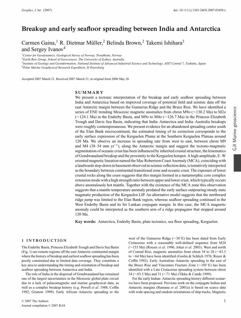
Figure 1. The satellite derived marine free-air gravity field along the East Antarctic margin, between Gunnerus Ridge and the Bruce Rise (outlined), illuminatedwith an azimuth of 330◦S (Sandwell & Smith 2005). Inset figure shows the location of our study area. Lines annotated (a–g) correspond to magnetic anomalyprofiles in Fig. 4a. Isochron C34 (∼83.5 Ma) from Muller et al. (1997) indicates the northern boundary of Cretaceous Quiet Zone crust along the SWIR, andlineament labelled 60.1 Ma indicates approximate timing and zone of breakup between Broken Ridge and Kerguelen Plateau (outlined). Abbreviations are asfollows: 1137, ODP Leg 183-site 1137; BR, Bruce Rise; EB, Elan Bank; EL, Enderby Land; GR, Gunnerus Ridge; KFZ, Kerguelen Fracture Zone; KL, KempLand; KPO Coast, Kron Prinz Olav Kyst; MRL, Mac.Robertson Land; PB, Prydz Bay; PEL, Princess Elizabeth Land; PET, Princess Elizabeth Trough; LHB,Lutzow-Holm Bay; QML, Queen Mary Land, RLS, Riiser-Larsen Land, SKP, Southern Kerguelen Plateau; SWIR, Southwest Indian Ridge; VFZ, VincennesFracture Zone and WL, Willem II Land.
anomaly identification off the conjugate Indian margin (e.g. Ramanaet al. 1994a,b; Banergee et al. 1995) has been inhibited by maskingand interference from thick Bengal Fan sediments (>5 km) and ig-neous structures such as the 85◦E and 90◦E ridges (Curray 1991).This has resulted in two, equivocal models with the identification ofmagnetic anomalies M11 (∼133 Ma) to M0 (∼120 Ma) by Ramanaet al. (1994a,b) and a model by Banergee et al. (1995) that proposesthat the seafloor created in the Bay of Bengal is younger than 116 Mawithin a portion of a long normal polarity interval, the CretaceousNormal Superchron (CNS) (∼118–83.5 Ma). More recently, Desaet al. (2006) have identified magnetic anomalies M11 (134 Ma) toM0 (120 Ma) south of Sri Lanka as a conjugate to the West Enderbyoceanic floor basin (Ramana et al. 2001b).
There have been some experimental three-component magne-tometer surveys conducted in the Enderby Basin region by JapaneseAntarctic Research Expeditions (JARE) during survey work on theicebreaker Shirase (e.g. Nogi et al. 1996). These data are thoughtto be helpful in detecting trends and lineations in areas with littledata coverage. Nogi et al. (1991, 1996) have presented a model fora Mesozoic vector sequence from M9 (∼130 Ma) with a generalNE–SW trend in the central Enderby Basin.
The uncertainty in magnetic anomaly identification in the Bay ofBengal and sparse data coverage off the Enderby Basin, PrincessElizabeth Trough, and in the Davis Sea has led to two alternativemodels for Cretaceous plate reconstructions for the Indian Ocean.One hypothesis is that the age of early ocean crust formed duringbreakup is largely Cretaceous Normal Superchron (CNS) (∼118–
83.5 Ma) crust with little or no Mesozoic sequence (e.g. Royer &Coffin 1992; Muller et al. 2000). An alternative hypothesis sug-gests that older Mesozoic crust (∼120+ Ma) does exist and thatspreading was roughly contemporaneous with the well-documentedM-sequence (M10–M0) off the Perth Abyssal Plain (Muller et al.1993; Powell et al. 1988).
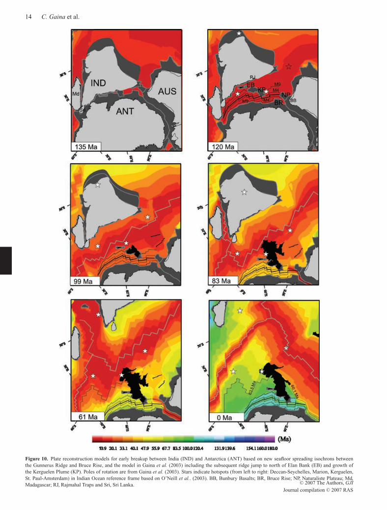
During the mid-Cretaceous period there was also increasing mag-matic activity in the region, related to the development of the Ker-gulen Large Igneous Province (LIP) from about 120 to 110 Ma (Freyet al. 2000; Nicolaysen et al. 2001). It is likely that the history ofearly seafloor spreading is complicated by ridge–hotspot interactionduring the growth of the Kerguelen Plume. The Elan Bank micro-continent was most probably isolated from the Indian continent byone or several ridge jumps associated with the Kerguelen Plume(Muller et al. 2001; Gaina et al. 2003).
Our recent compilation of shiptrack potential field data in the En-derby Basin, Princess Elizabeth Trough and Davis Sea offers an op-portunity to address questions about the early breakup and spreadinghistory between India and Antarctica. We show the improved surveycoverage of potential field and seismic data from both new and ex-isting sources and present an interpretation of a Mesozoic seafloorspreading sequence based on marine magnetic anomaly data. Weexamine the tectono-magmatic variation along-axis of the zone ofbreakup, and spreading segmentation off the Antarctic margin, usingpotential field data and seismic refraction and reflection data. Wealso show supporting evidence for an abandoned ‘fossil’ spread-ing centre, in the Enderby Basin, west of Kerguelen Plateau and
C© 2007 The Authors, GJI
Journal compilation C© 2007 RAS
June 3, 2007 16:26 Geophysical Journal International gji3450
Breakup and early seafloor spreading between India and Antarctica 3
discuss the development of the early spreading system in the con-text of mantle–lithosphere interaction with the growth and influenceof the Kerguelen Plume.
2 P H Y S I O G R A P H I C S E T T I N G
The region off the East Antarctic margin once conjugate to SouthernGreater India (e.g., Powell et al. 1988; Harley & Henson 1990;Ramana et al. 1994a) extends over a large part of the Enderby Basin,the Princess Elizabeth Trough and the Davis Sea Basin (Fig. 1). TheEnderby Basin is a wide area located between the Kerguelen Plateauand the Antarctic margin, bounded to the northwest by the KerguelenFracture Zone and by the Crozet Basin. It includes the area conjugateto the eastern Indian continental margin, and extends across EnderbyLand, Kemp Land, Mac Robertson Land and Princess ElizabethLand. The Princess Elizabeth Trough, to the east of the EnderbyBasin, is a narrow zone that separates the southern extension of theKerguelen Plateau from the Antarctic margin. The Davis Sea, furtherto the east, is the area where Southern Greater India and Australiawere once joined to Antarctica, in the region offshore Wilhelm IILand and Queen Mary Land. The Russian and Japanese Antarcticprograms named the western Enderby Basin the Cosmonaut Sea andthe eastern Enderby Basin the Co-operation Sea (e.g. Joshima et al.2001).
Our study area extends from approximately 30◦E to 105◦E be-tween the Gunnerus Ridge and Bruce Rise (Fig. 1). Gunnerus Ridgeis a narrow, submarine ridge that lies perpendicular to the Antarc-tic margin; it consists mostly of continental crust with an igneousstructure at its northern tip (Bergh 1987; Roeser et al. 1996). Tothe east of Gunnerus Ridge, Sri Lanka has been correlated with theonshore Pre-Cambrian terranes at Lutzow-Holm Bay (e.g. Fedorovet al. 1982; Yoshida et al. 1992; Buchel 1994, Shiraishi et al. 1994;Kriegsman 1995; Yoshida et al. 1996; Lawver et al. 1998). In be-tween Gunnerus Ridge and Bruce Rise lies the Prydz Bay-LambertGraben structure; geophysical and geological correlation suggeststhat it is part of a pre-existing N–S Palaeozoic intracontinental rift,conjugate with the Mahanadi Graben in eastern India (Fedorov et al.1982; Stagg 1985; Lisker et al. 2003). The graben has undergonean active tectonic history with repeated intrusive and extrusive ig-neous activity, and inferred uplift around Miocene to Recent times(Wellman & Tingey 1982). The Bruce Rise is a crystalline conti-nental basement plateau that has been correlated to the NaturalistePlateau off the southwest Australian margin (Murakami et al. 2000;Stagg et al. 2004). The eastern flank of the Bruce Rise is adjacent tothe Vincennes Fracture Zone, which is conjugate to the Perth Frac-ture Zone and related to Australian–Antarctic spreading along theSoutheast Indian Ridge (Tikku & Cande 1999).
The physiographic setting of the region is dominated by igneousstructures related to the Kerguelen Large Igneous Province (LIP),as well as large areas of relatively thick sediment. It is possiblethat a large area of seafloor and potentially a number of continen-tal fragments are now overprinted by voluminous igneous activ-ity associated with the Kerguelen Plume, which began forming atthe Southern Kerguelen Plateau at about 118 ± 2 Ma (Frey et al.2000; Nicolaysen et al. 2001). ODP Legs 119 (sites 738–746), 120(sites 747–751) and 183 (sites 1135–1142) were drilled with theobject of investigating the Kerguelen LIP. In particular, the recov-ery of core material including garnet-biotite gneiss on Elan Bankat ODP 183 (site 1137) indicated a continental origin (Nicolaysenet al. 2001). Several wide-angle and reflection seismic profiles ac-quired by French and Australian surveys describe the crustal prop-
erties and structure of the microcontinent (Charvis & Operto 1999;Gladczenko & Coffin 2001; Borissova et al. 2003) and the basinsdirectly off the Kerguelen Plateau, including the Labuan Basin(Borissova et al. 2002).
The marine free-air gravity field anomalies derived from satellitealtimetry (Smith & Sandwell 1997) do not resolve many shorterwavelength free-air gravity features off the Antarctic margin dueto areas of thick ice and/or sediment cover (e.g. McAdoo & Laxon1997; Rotstein et al. 2001). Sediment thickness is commonly 1–2 km in the abyssal plain and increases up to 6–8 km in areas towardthe continental margin (Mizukoshi et al. 1986; Murakami et al.2000; Stagg et al. 2004). As a consequence, the identification ofbasement fabric, such as the gravimetric expressions of fracturezones (e.g. Goslin & Schlich 1982) is difficult. Further to the north ofthe study area a series of relatively short NNE-trending fracture zonelineations can be observed and the might indicate the development ofoceanic crust between East Antarctica and India/Sri Lanka youngerthan 120 Myr. The parallel series of NNE fracture zones locatednorth of Gunnerus Ridge also extend into the Riiser-Larsen Sea;they are more likely to belong to the Africa–Antarctica (AFR–ANT)spreading system described by Nogi et al. (1996) and Jokat et al.(2003). To the north they are truncated by NNW fracture zones inthe Crozet Basin (Fig. 1), which includes CNS crust, south of theC34 isochron (∼83.5 Ma).
3 DATA
In addition to existing open-file geophysical data from theNational Geophysical Data Center (NGDC 1998) and older Frenchsurveys (R/V Marion Dufresne surveys 1, 5, 11, 38 and 47) (e.g.Goslin & Schlich 1982), there are several more recent offshoresurvey programs that have vastly improved shiptrack data cover-age in the Enderby Basin region. These surveys include: JapanNational Oil Company (JNOC) TH83, TH84, TH85, TH98 andTH99 (e.g. Mizukoshi et al. 1986; Murakami et al. 2000; Joshimaet al. 2001), Soviet Antarctic Expeditions/Russian Antarctic Expe-ditions surveys 31–47 (e.g. Gandyukin et al. 2002; Golynsky et al.2002) and Geoscience Australia surveys 228 and 229 (e.g. Stagg &Colwell 2003). There has been a unique opportunity through vari-ous data agreements to compile virtually all the available shiptrackmagnetic anomaly, free-air gravity and bathymetry data in the En-derby Basin, Princess Elizabeth Trough and Davis Sea, between ap-proximately 30◦E and 110◦E. This has provided the most completemagnetic anomaly data set for the region to date; Fig. 2 providesa summary of the coverage of both the older and new data sets.The marine free-air gravity field derived from satellite altimetry(Sandwell & Smith 2005) and GEBCO bathymetry (GEBCO 2004)were used in this study, in conjunction with magnetic anomaly datato identify the age of seafloor spreading and tectonic structure of theEnderby Basin. Additional access to some seismic reflection profiles(Australian and Japanese survey data) and sonobuoy velocity–depthdata (Japanese, Russian and Australian surveys) has allowed us tobuild upon our interpretation of potential field data. A detailed de-scription of this integrated seismic data set is included in Stagg et al.(2004).
3.1 Magnetic anomalies
The newly collated magnetic anomaly data (Fig. 2) were reformattedand assembled into one database. Magnetic data collected at theselatitudes are often more affected by electromagnetic disturbances
C© 2007 The Authors, GJI
Journal compilation C© 2007 RAS
June 3, 2007 16:26 Geophysical Journal International gji3450
4 C. Gaina et al.
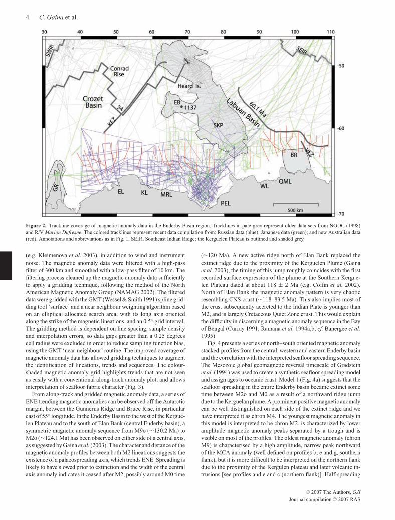
Figure 2. Trackline coverage of magnetic anomaly data in the Enderby Basin region. Tracklines in pale grey represent older data sets from NGDC (1998)and R/V Marion Dufresne. The colored tracklines represent recent data compilation from: Russian data (blue); Japanese data (green); and new Australian data(red). Annotations and abbreviations as in Fig. 1, SEIR, Southeast Indian Ridge; the Kerguelen Plateau is outlined and shaded grey.
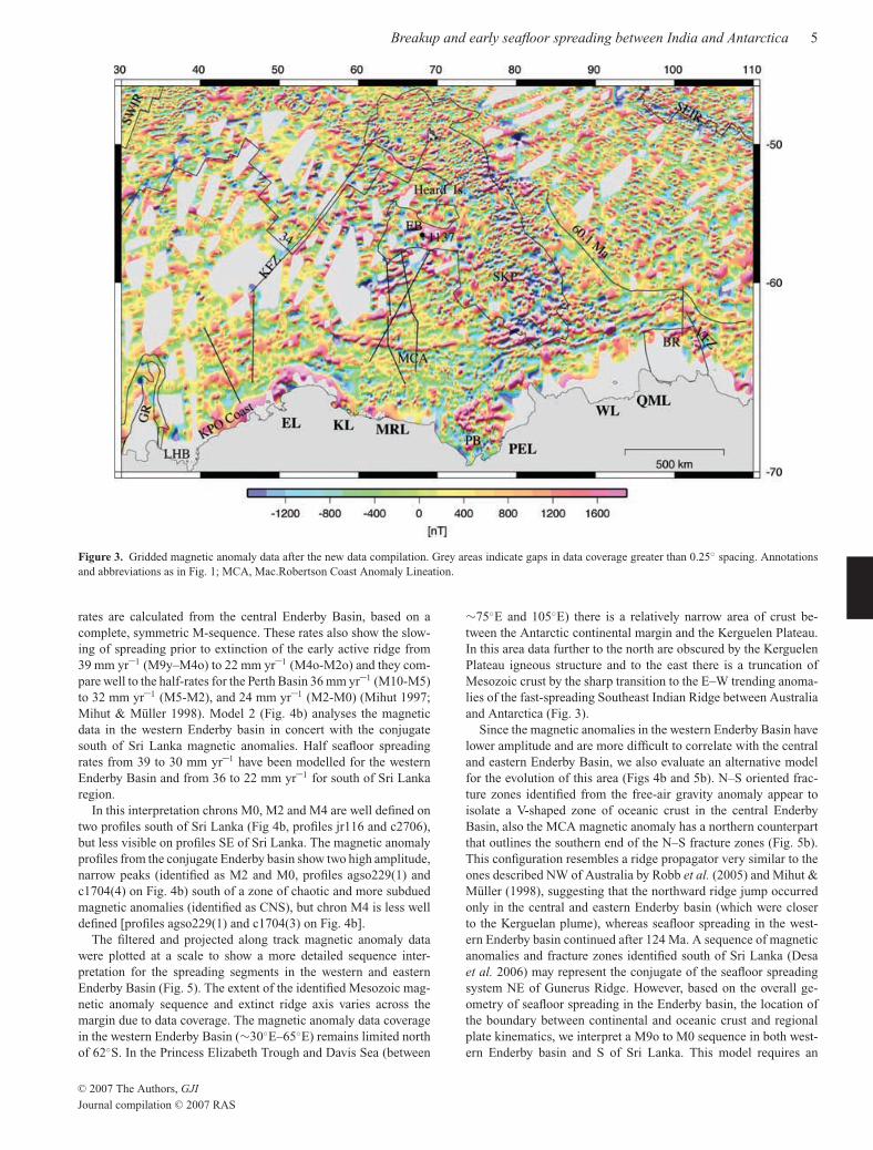
(e.g. Kleimenova et al. 2003), in addition to wind and instrumentnoise. The magnetic anomaly data were filtered with a high-passfilter of 300 km and smoothed with a low-pass filter of 10 km. Thefiltering process cleaned up the magnetic anomaly data sufficientlyto apply a gridding technique, following the method of the NorthAmerican Magnetic Anomaly Group (NAMAG 2002). The filtereddata were gridded with the GMT (Wessel & Smith 1991) spline grid-ding tool ‘surface’ and a near neighbour weighting algorithm basedon an elliptical allocated search area, with its long axis orientedalong the strike of the magnetic lineations, and an 0.5◦ grid interval.The gridding method is dependent on line spacing, sample densityand interpolation errors, so data gaps greater than a 0.25 degreescell radius were excluded in order to reduce sampling function bias,using the GMT ‘near-neighbour’ routine. The improved coverage ofmagnetic anomaly data has allowed gridding techniques to augmentthe identification of lineations, trends and sequences. The colour-shaded magnetic anomaly grid highlights trends that are not seenas easily with a conventional along-track anomaly plot, and allowsinterpretation of seafloor fabric character (Fig. 3).
From along-track and gridded magnetic anomaly data, a series ofENE trending magnetic anomalies can be observed off the Antarcticmargin, between the Gunnerus Ridge and Bruce Rise, in particulareast of 55◦ longitude. In the Enderby Basin to the west of the Kergue-len Plateau and to the south of Elan Bank (central Enderby basin), asymmetric magnetic anomaly sequence from M9o (∼130.2 Ma) toM2o (∼124.1 Ma) has been observed on either side of a central axis,as suggested by Gaina et al. (2003). The character and distance of themagnetic anomaly profiles between both M2 lineations suggests theexistence of a palaeospreading axis, which trends ENE. Spreading islikely to have slowed prior to extinction and the width of the centralaxis anomaly indicates it ceased after M2, possibly around M0 time
(∼120 Ma). A new active ridge north of Elan Bank replaced theextinct ridge due to the proximity of the Kerguelen Plume (Gainaet al. 2003), the timing of this jump roughly coincides with the firstrecorded surface expression of the plume at the Southern Kergue-len Plateau dated at about 118 ± 2 Ma (e.g. Coffin et al. 2002).North of Elan Bank the magnetic anomaly pattern is very chaoticresembling CNS crust (∼118–83.5 Ma). This also implies most ofthe crust subsequently accreted to the Indian Plate is younger thanM2, and is largely Cretaceous Quiet Zone crust. This would explainthe difficulty in discerning a magnetic anomaly sequence in the Bayof Bengal (Curray 1991; Ramana et al. 1994a,b; cf. Banergee et al.1995)
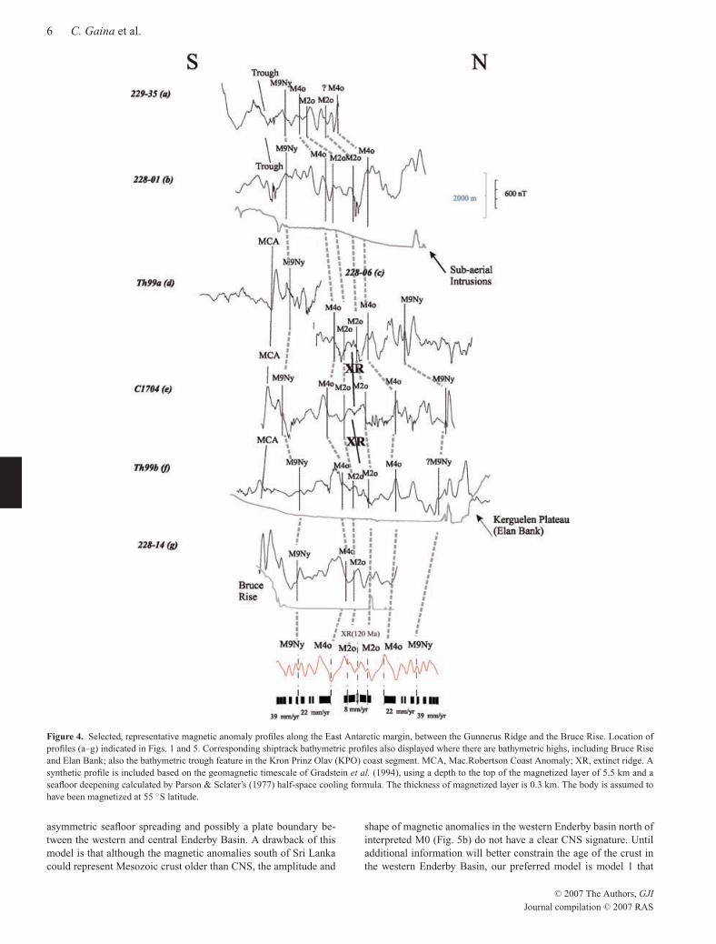
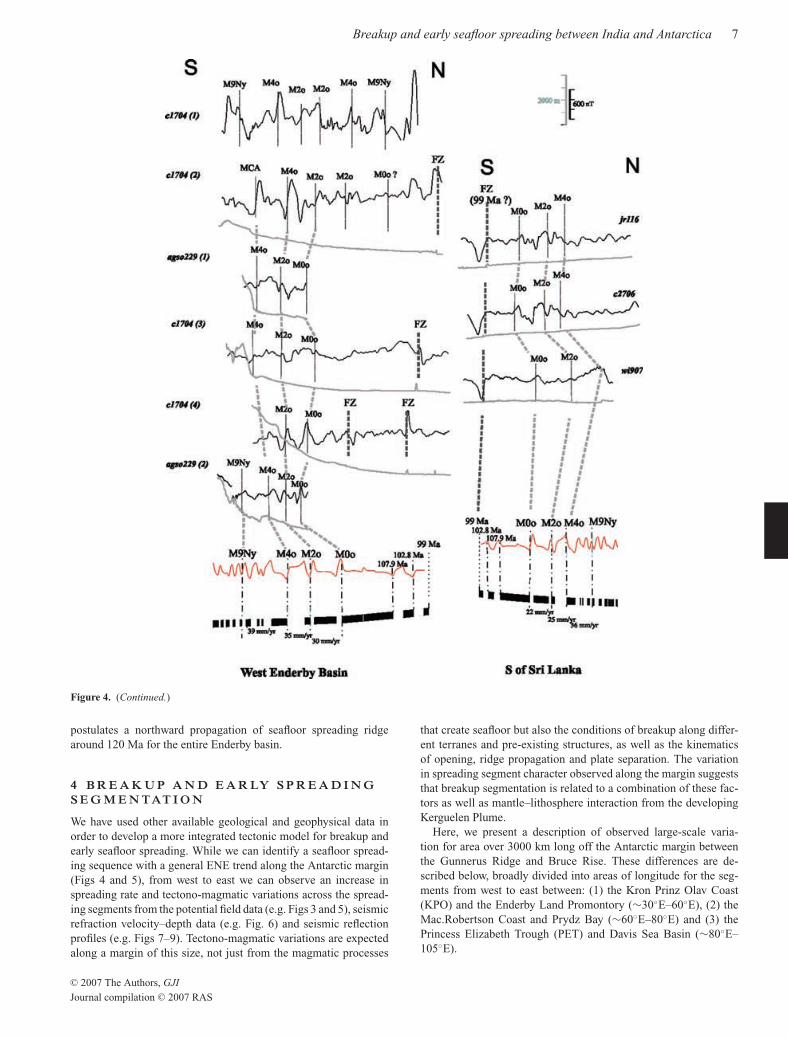
Fig. 4 presents a series of north–south oriented magnetic anomalystacked-profiles from the central, western and eastern Enderby basinand the correlation with the interpreted seafloor spreading sequence.The Mesozoic global geomagnetic reversal timescale of Gradsteinet al. (1994) was used to create a synthetic seafloor spreading modeland assign ages to oceanic crust. Model 1 (Fig. 4a) suggests that theseafloor spreading in the entire Enderby basin became extinct sometime between M2o and M0 as a result of a northward ridge jumpdue to the Kerguelan plume. A prominent positive magnetic anomalycan be well distinguished on each side of the extinct ridge and wehave interpreted it as chron M4. The youngest magnetic anomaly inthis model is interpreted to be chron M2, is characterized by loweramplitude magnetic anomaly peaks separated by a trough and isvisible on most of the profiles. The oldest magnetic anomaly (chronM9) is characterised by a high amplitude, narrow peak northwardof the MCA anomaly (well defined on profiles b, e and g, southernflank), but it is more difficult to be interpreted on the northern flankdue to the proximity of the Kergulen plateau and later volcanic in-trusions [see profiles and e and c (northern flank)]. Half-spreading
C© 2007 The Authors, GJI
Journal compilation C© 2007 RAS
June 3, 2007 16:26 Geophysical Journal International gji3450
Breakup and early seafloor spreading between India and Antarctica 5
Figure 3. Gridded magnetic anomaly data after the new data compilation. Grey areas indicate gaps in data coverage greater than 0.25◦ spacing. Annotationsand abbreviations as in Fig. 1; MCA, Mac.Robertson Coast Anomaly Lineation.
rates are calculated from the central Enderby Basin, based on acomplete, symmetric M-sequence. These rates also show the slow-ing of spreading prior to extinction of the early active ridge from39 mm yr–1 (M9y–M4o) to 22 mm yr–1 (M4o-M2o) and they com-pare well to the half-rates for the Perth Basin 36 mm yr–1 (M10-M5)to 32 mm yr–1 (M5-M2), and 24 mm yr–1 (M2-M0) (Mihut 1997;Mihut & Muller 1998). Model 2 (Fig. 4b) analyses the magneticdata in the western Enderby basin in concert with the conjugatesouth of Sri Lanka magnetic anomalies. Half seafloor spreadingrates from 39 to 30 mm yr–1 have been modelled for the westernEnderby Basin and from 36 to 22 mm yr–1 for south of Sri Lankaregion.
In this interpretation chrons M0, M2 and M4 are well defined ontwo profiles south of Sri Lanka (Fig 4b, profiles jr116 and c2706),but less visible on profiles SE of Sri Lanka. The magnetic anomalyprofiles from the conjugate Enderby basin show two high amplitude,narrow peaks (identified as M2 and M0, profiles agso229(1) andc1704(4) on Fig. 4b) south of a zone of chaotic and more subduedmagnetic anomalies (identified as CNS), but chron M4 is less welldefined [profiles agso229(1) and c1704(3) on Fig. 4b].
The filtered and projected along track magnetic anomaly datawere plotted at a scale to show a more detailed sequence inter-pretation for the spreading segments in the western and easternEnderby Basin (Fig. 5). The extent of the identified Mesozoic mag-netic anomaly sequence and extinct ridge axis varies across themargin due to data coverage. The magnetic anomaly data coveragein the western Enderby Basin (∼30◦E–65◦E) remains limited northof 62◦S. In the Princess Elizabeth Trough and Davis Sea (between
∼75◦E and 105◦E) there is a relatively narrow area of crust be-tween the Antarctic continental margin and the Kerguelen Plateau.In this area data further to the north are obscured by the KerguelenPlateau igneous structure and to the east there is a truncation ofMesozoic crust by the sharp transition to the E–W trending anoma-lies of the fast-spreading Southeast Indian Ridge between Australiaand Antarctica (Fig. 3).
Since the magnetic anomalies in the western Enderby Basin havelower amplitude and are more difficult to correlate with the centraland eastern Enderby Basin, we also evaluate an alternative modelfor the evolution of this area (Figs 4b and 5b). N–S oriented frac-ture zones identified from the free-air gravity anomaly appear toisolate a V-shaped zone of oceanic crust in the central EnderbyBasin, also the MCA magnetic anomaly has a northern counterpartthat outlines the southern end of the N–S fracture zones (Fig. 5b).This configuration resembles a ridge propagator very similar to theones described NW of Australia by Robb et al. (2005) and Mihut &Muller (1998), suggesting that the northward ridge jump occurredonly in the central and eastern Enderby basin (which were closerto the Kerguelan plume), whereas seafloor spreading in the west-ern Enderby basin continued after 124 Ma. A sequence of magneticanomalies and fracture zones identified south of Sri Lanka (Desaet al. 2006) may represent the conjugate of the seafloor spreadingsystem NE of Gunerus Ridge. However, based on the overall ge-ometry of seafloor spreading in the Enderby basin, the location ofthe boundary between continental and oceanic crust and regionalplate kinematics, we interpret a M9o to M0 sequence in both west-ern Enderby basin and S of Sri Lanka. This model requires an
C© 2007 The Authors, GJI
Journal compilation C© 2007 RAS
June 3, 2007 16:26 Geophysical Journal International gji3450
6 C. Gaina et al.
Figure 4. Selected, representative magnetic anomaly profiles along the East Antarctic margin, between the Gunnerus Ridge and the Bruce Rise. Location ofprofiles (a–g) indicated in Figs. 1 and 5. Corresponding shiptrack bathymetric profiles also displayed where there are bathymetric highs, including Bruce Riseand Elan Bank; also the bathymetric trough feature in the Kron Prinz Olav (KPO) coast segment. MCA, Mac.Robertson Coast Anomaly; XR, extinct ridge. Asynthetic profile is included based on the geomagnetic timescale of Gradstein et al. (1994), using a depth to the top of the magnetized layer of 5.5 km and aseafloor deepening calculated by Parson & Sclater’s (1977) half-space cooling formula. The thickness of magnetized layer is 0.3 km. The body is assumed tohave been magnetized at 55 ◦S latitude.
asymmetric seafloor spreading and possibly a plate boundary be-tween the western and central Enderby Basin. A drawback of thismodel is that although the magnetic anomalies south of Sri Lankacould represent Mesozoic crust older than CNS, the amplitude and
shape of magnetic anomalies in the western Enderby basin north ofinterpreted M0 (Fig. 5b) do not have a clear CNS signature. Untiladditional information will better constrain the age of the crust inthe western Enderby Basin, our preferred model is model 1 that
C© 2007 The Authors, GJI
Journal compilation C© 2007 RAS
June 3, 2007 16:26 Geophysical Journal International gji3450
Breakup and early seafloor spreading between India and Antarctica 7
Figure 4. (Continued.)
postulates a northward propagation of seafloor spreading ridgearound 120 Ma for the entire Enderby basin.
4 B R E A K U P A N D E A R LY S P R E A D I N GS E G M E N TAT I O N
We have used other available geological and geophysical data inorder to develop a more integrated tectonic model for breakup andearly seafloor spreading. While we can identify a seafloor spread-ing sequence with a general ENE trend along the Antarctic margin(Figs 4 and 5), from west to east we can observe an increase inspreading rate and tectono-magmatic variations across the spread-ing segments from the potential field data (e.g. Figs 3 and 5), seismicrefraction velocity–depth data (e.g. Fig. 6) and seismic reflectionprofiles (e.g. Figs 7–9). Tectono-magmatic variations are expectedalong a margin of this size, not just from the magmatic processes
that create seafloor but also the conditions of breakup along differ-ent terranes and pre-existing structures, as well as the kinematicsof opening, ridge propagation and plate separation. The variationin spreading segment character observed along the margin suggeststhat breakup segmentation is related to a combination of these fac-tors as well as mantle–lithosphere interaction from the developingKerguelen Plume.
Here, we present a description of observed large-scale varia-tion for area over 3000 km long off the Antarctic margin betweenthe Gunnerus Ridge and Bruce Rise. These differences are de-scribed below, broadly divided into areas of longitude for the seg-ments from west to east between: (1) the Kron Prinz Olav Coast(KPO) and the Enderby Land Promontory (∼30◦E–60◦E), (2) theMac.Robertson Coast and Prydz Bay (∼60◦E–80◦E) and (3) thePrincess Elizabeth Trough (PET) and Davis Sea Basin (∼80◦E–105◦E).
C© 2007 The Authors, GJI
Journal compilation C© 2007 RAS
June 3, 2007 16:26 Geophysical Journal International gji3450
8 C. Gaina et al.
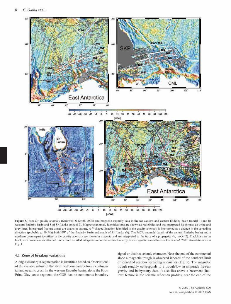
Figure 5. Free air gravity anomaly (Sandwell & Smith 2005) and magnetic anomaly data in the (a) western and eastern Enderby basin (model 1) and b)western Enderby basin and S of Sri Lanka (model 2). Magnetic anomaly identifications are shown as red circles and the interpreted isochrones as white andgrey lines. Interpreted fracture zones are drawn in orange. A V-shaped lineation identified in the gravity anomaly is interpreted as a change in the spreadingdirection (probably at 99 Ma) both NW of the Enderby basin and south of Sri Lanka (b). The MCA anomaly (south of the central Enderby basin) and anorthern counterpart identified in the gravity anomaly are shown in magenta and are interpreted as the trace of a propagator (b, model 2). Tracklines are inblack with cruise names attached. For a more detailed interpretation of the central Enderby basin magnetic anomalies see Gaina et al. 2003. Annotations as inFig. 1.
4.1 Zone of breakup variations
Along-axis margin segmentation is identified based on observationsof the variable nature of the identified boundary between continen-tal and oceanic crust. In the western Enderby basin, along the KronPrinz Olav coast segment, the COB has no continuous boundary
signal or distinct seismic character. Near the end of the continentalslope a magnetic trough is observed inboard of the southern limitof identified seafloor spreading anomalies (Fig. 5). The magnetictrough roughly corresponds to a trough/low in shiptrack free-airgravity and bathymetry data. It also lies above a basement ‘hol-low’ feature in the seismic reflection profiles, near the end of the
C© 2007 The Authors, GJI
Journal compilation C© 2007 RAS
June 3, 2007 16:26 Geophysical Journal International gji3450
Breakup and early seafloor spreading between India and Antarctica 9
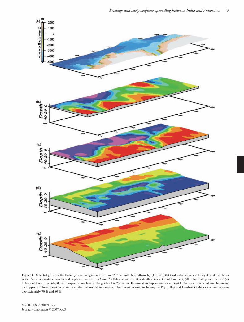
Figure 6. Selected grids for the Enderby Land margin viewed from 220◦ azimuth. (a) Bathymetry [Etopo5); (b) Gridded sonobouy velocity data at the 6km/sisovel. Seismic crustal character and depth estimated from Crust 2.0 (Masters et al. 2000), depth to (c) to top of basement; (d) to base of upper crust and (e)to base of lower crust (depth with respect to sea level). The grid cell is 2 minutes. Basement and upper and lower crust highs are in warm colours, basementand upper and lower crust lows are in colder colours. Note variations from west to east, including the Prydz Bay and Lambert Graben structure betweenapproximately 70◦E and 80◦E.
C© 2007 The Authors, GJI
Journal compilation C© 2007 RAS
June 3, 2007 16:26 Geophysical Journal International gji3450
10 C. Gaina et al.
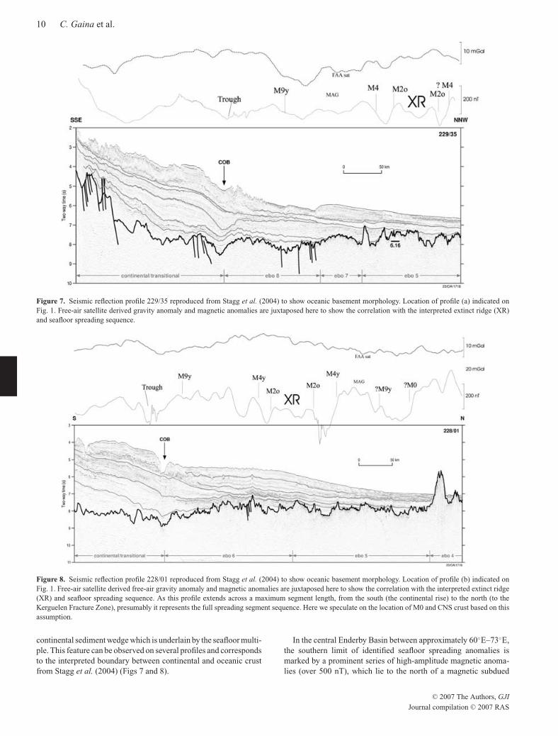
Figure 7. Seismic reflection profile 229/35 reproduced from Stagg et al. (2004) to show oceanic basement morphology. Location of profile (a) indicated onFig. 1. Free-air satellite derived gravity anomaly and magnetic anomalies are juxtaposed here to show the correlation with the interpreted extinct ridge (XR)and seafloor spreading sequence.
Figure 8. Seismic reflection profile 228/01 reproduced from Stagg et al. (2004) to show oceanic basement morphology. Location of profile (b) indicated onFig. 1. Free-air satellite derived free-air gravity anomaly and magnetic anomalies are juxtaposed here to show the correlation with the interpreted extinct ridge(XR) and seafloor spreading sequence. As this profile extends across a maximum segment length, from the south (the continental rise) to the north (to theKerguelen Fracture Zone), presumably it represents the full spreading segment sequence. Here we speculate on the location of M0 and CNS crust based on thisassumption.
continental sediment wedge which is underlain by the seafloor multi-ple. This feature can be observed on several profiles and correspondsto the interpreted boundary between continental and oceanic crustfrom Stagg et al. (2004) (Figs 7 and 8).
In the central Enderby Basin between approximately 60◦E–73◦E,the southern limit of identified seafloor spreading anomalies ismarked by a prominent series of high-amplitude magnetic anoma-lies (over 500 nT), which lie to the north of a magnetic subdued
C© 2007 The Authors, GJI
Journal compilation C© 2007 RAS
June 3, 2007 16:26 Geophysical Journal International gji3450
Breakup and early seafloor spreading between India and Antarctica 11
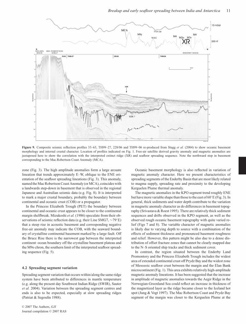
Figure 9. Composite seismic reflection profiles 33–63, TH99–27, 228/06 and TH99–06 re-produced from Stagg et al. (2004) to show oceanic basementmorphology and internal crustal character. Location of profiles indicated on Fig. 1. Free-air satellite derived gravity anomaly and magnetic anomalies arejuxtaposed here to show the correlation with the interpreted extinct ridge (XR) and seafloor spreading sequence. Note the northward step in basementcorresponding to the Mac.Robertson Coast Anomaly (MCA).
zone (Fig. 3). The high amplitude anomalies form a large arcuatelineation that trends approximately E–W, oblique to the ENE ori-entation of the seafloor spreading lineations (Fig. 3). This anomaly,named the Mac Robertson Coast Anomaly (or MCA), coincides witha landwards step-down in basement that is observed in the regionalJapanese and Australian seismic data (e.g. Fig. 8). It is interpretedto mark a major crustal boundary, probably the boundary betweencontinental and oceanic crust (COB) or a propagator.
In the Princess Elizabeth Trough (PET) the boundary betweencontinental and oceanic crust appears to be closer to the continentalmargin shelfbreak. Mizukoshi et al. (1986) speculate from their ob-servations of seismic reflection data (e.g. their Line SMG7, ∼79◦E)that a steep rise in acoustic basement and corresponding negativefree-air anomaly may indicate the COB, with the seaward bound-ary of crystalline continental basement marked by a large fault. Offthe Bruce Rise there is the narrowest gap between the interpretedcontinent–ocean boundary off the crystalline basement plateau andthe M9o chron, the southern limit of the interpreted seafloor spread-ing sequence (Fig. 5).
4.2 Spreading segment variation
Spreading segment variation that occurs within/along the same ridgesystem have been attributed to differences in mantle temperature(e.g. along the present day Southwest Indian Ridge (SWIR), Sauteret al. 2004). Variation between the spreading segment centres andends is also to be expected, especially at slow spreading ridges(Patriat & Segoufin 1988).
Oceanic basement morphology is also reflected in variation ofmagnetic anomaly character. Here we present characteristics ofspreading segments of the Enderby Basin that are most likely relatedto magma supply, spreading rate and proximity to the developingKerguelen Plume thermal anomaly.
The magnetic anomalies in the KPO segment trend roughly ENEbut have more variable shape than those to the east of 60◦E (Fig. 3). Ingeneral, thick sediments and water depth contribute to the variationin magnetic anomaly character as do differences in basement topog-raphy (Srivastava & Roest 1995). There are relatively thick sedimentsequences and drifts observed in the KPO segment, as well as theobserved rough oceanic basement topography with quite varied re-lief (Figs 7 and 8). The variable character of magnetic anomaliesis likely due to varying depth to source with a combination of theeffects of sediment thickness and pronounced basement roughnessand relief. However, this pattern might be also due to a dense dis-tribution of offset fracture zones that cannot be clearly mapped dueto the N–S oriented ship tracks and thick sediment cover.
In contrast, the region situated between the Enderby LandPromontory and the Princess Elizabeth Trough includes the widestarea of extended continental crust off Prydz Bay and the widest zoneof Mesozoic seafloor crust between the margin and the Elan Bankmicrocontinent (Fig. 1). This area exhibits relatively high-amplitudemagnetic anomaly lineations. It has been suggested that the increasein amplitude of magnetic anomalies towards the Aegir Ridge in theNorwegian-Greenland Sea could reflect an increase in thickness ofthe magnetized layer as the ridge became closer to the Iceland hotspot (Jung & Vogt 1997). The Mac Robertson Coast and Prydz Baysegment of the margin was closer to the Kerguelen Plume at the
C© 2007 The Authors, GJI
Journal compilation C© 2007 RAS

June 3, 2007 16:26 Geophysical Journal International gji3450
12 C. Gaina et al.
time of formation and this is reflected in the type of oceanic crustobserved. Charvis & Operto (1999) indicate areas of crustal thick-ness up to 10–13 km from OBS data transects near the southwest ofElan Bank.
In the central Enderby Basin, Princess Elizabeth Trough andDavis Sea area deep-crustal Australian seismic profiles image dif-ferent types of oceanic basement morphology and crustal structure(e.g. Stagg et al. 2004; Figs 7–9). Seismic profiles in the westernEnderby Basin off the Kron Prinz Olav (KPO) coast segment exhibita pronounced oceanic basement roughness with a crustal structurecharacterized by chaotic internal reflectors. The seismic profilesintersect several fracture zones at an oblique angle, which might ex-plain part of the basement roughness. In comparison, to the east ofthis segment, in the central Enderby Basin and Davis Sea, oceanicbasement topography observed in Australian and Japanese seismicreflection profiles is generally low relief without any pronouncedroughness. Profiles in the eastern segments often exhibit high am-plitude reflectors characterizing internal crustal features and strongMoho. In particular, the seismic character of many profiles in theMCA sector and the Davis Sea, close to the Kerguelen Plateau area,exhibit an internal reflector pattern that looks similar to an irregularseries of diagonal crosses; they are comparable to the type of crustobserved in the Cuvier Abyssal Plain off Western Australia (Colwellet al. 1994).
The PET spreading segment lies off a narrower area of continen-tal shelf. The area also comprises of a reasonably complex zone ofoceanic crust as it was formerly adjacent to the Cretaceous triplejunction between Antarctica, Greater India and Australia and anarea of crust left over from the division of the Broken Ridge andKerguelen Plateau by the SEIR at about 61 Ma. The Broken Ridge-Kerguelen Plateau experienced some shear motion prior to theirseparation, and some minor deformation that may be related to thisevent is imaged in seismic reflection lines as a deformation zonewith more chaotic or disturbed sediments. Surprisingly, there is noevidence from seismic reflection profiles for the rough oceanic base-ment topography that is observed at the conjugate Diamantina Zone,which extends from Broken Ridge to the Great Australian Bight.
Stagg et al. (2004) suggest the division of at least two crustalprovinces between the western and eastern Enderby Basin segmentsbased on the observed variation of oceanic crustal morphology andseismic structure. This variation is reflected in differences of thevelocity–depth structure of oceanic crust between the western andeastern spreading segments in the Enderby Basin (Fig. 6). The areabetween the eastern and western Enderby Basin provinces appearsto be a highly segmented offset zone probably because it is thelocation of maximum curvature in the spreading system, north ofthe Enderby Land promontory. Margin segmentation is also likelyinfluenced by major continental crustal discontinuities. Recent on-shore/continental seismic lithospheric thickness studies (Morelli &Danesi 2004) indicate a discontinuity at about 60◦E and at 90◦E.
There is also a cluster of seamounts populating the region nearElan Bank (Fig. 1) as opposed to other segments where there areonly a few scattered seamounts observed closer to the Antarctic con-tinental margin. This seamount cluster appears to be at an obliqueorientation to the early spreading direction, and follows rather asimilar trend to the younger Kerguelen Fracture Zone. The prox-imity to the Kerguelen Plateau leads to the suggestion that the tim-ing and nature of their emplacement are related to the Kerguelenplume. Volcanic elongated ridges are thought to be formed mainlyby extrusive volcanism in a melt-channel. For instance, the Musicianseamounts chain related to the Hawaiian Plume are oblique to thehotspot trace (Kopp et al. 2003), where hotspot–ridge interaction
leads to asthenospheric channeling from the plume to the nearbyspreading centre over a maximum distance of 400 km. Often theamount of excess hotspot volcanism is related to the spreading rate,where intermediate-slow ridges can focus the plume to the ridge butnot be enough to entrain all the excess melt (Jellinek et al. 2003).The extra magmatic activity is not unexpected in this region whereridge–hotspot interaction isolated the Elan Bank microcontinent.
4.3 A ‘Fossil’ spreading centre
Several lines of evidence suggest the existence of an extinct ‘fossil’spreading centre in the central Enderby Basin. From the magneticdata, we could not clearly identify chron M0, but the two conjugateM2o magnetic anomalies observed in the central Enderby basin areseparated by a trough that signifies seafloor spreading continueduntil the next normal polarity (approximately 120 Ma). A syntheticmodel that matches the observed pattern and distances between con-jugate M2o chrons indicates that seafloor spreading rate dropped toaround 8 mm yr–1 (half spreading rate) before becoming extinct(Fig. 4a).
In addition to the observed magnetic anomaly pattern, there arecorresponding changes in free-air gravity and oceanic basementmorphology around the central axis of the abandoned spreadingcentre, which suggests that there is a remnant crustal feature in thiszone. Sedimentary sequences are up to 2 km thick and thereforetoo thick to reveal a bathymetric expression of the extinct ridge fea-ture. A basement feature that might be interpreted as an abandonedspreading centre is visible in the seismic data from the central En-derby basin (Fig. 9), but the rough basement structure of the westernEnderby basin makes difficult to recognize any possible fossil ridge(Figs 7 and 8). The location of the extinct ridge identified by mag-netic anomalies is characterized by a step in the satellite derivedfree air gravity anomaly in the western Enderby basin (Figs 7 and8), and a peak in the gravity anomaly in the central Enderby basin(Fig. 9).
The differences in the gravity anomaly signature along the extinctridge might indicate differences in the last stage of seafloor spread-ing within the Enderby basin. Many studies suggest that before activeaccretion ceases, there is a protracted period whereby the spread-ing rate slows (e.g. Osler & Louden 1995; Grevemeyer et al. 1996;Livermore et al. 2000). The change in crustal thickness or magmacomposition as spreading slows is often reflected by a change in thegravity anomaly at extinct ridges. Some observations and modelssuggest the spreading rate and crustal variation in this zone resultsin more anomalous features like a deeper ridge or thinner crust, andpossibly even the remains of a palaeomagma chamber structure.Evidence from seismic refraction studies at the extinct spreadingcentre in the Labrador Sea indicates thinner crust and lower crustalvelocities (e.g. Osler & Louden 1995). These features associatedwith the Labrador extinct ridge correspond to a gravity low. Thegravity high observed at the inferred extinct spreading centre inthe Enderby Basin is one of the few extinct ridges characterized bya positive gravity anomaly. This positive gravity anomaly may berelated to a crustal structure generated by a relatively higher thannormal spreading rate prior to extinction, as explained below.
The largest variation of oceanic crustal thickness as a functionof spreading rate is observed when spreading rates are less than15–10 mm yr–1 (e.g. Reid & Jackson 1981; White 1992; Bown &White 1995). Most half-spreading rates calculated at other extinctridges indicate a slowing to quite low rates prior to extinction of theactive ridge; for example, the Labrador system slowed from 10 to
C© 2007 The Authors, GJI
Journal compilation C© 2007 RAS

June 3, 2007 16:26 Geophysical Journal International gji3450
Breakup and early seafloor spreading between India and Antarctica 13
3 mm yr–1 (Srivastava & Keen 1995) and the Aegir system slowedto between 8 and 5 mm yr–1 (Jung & Vogt 1997). In the EnderbyBasin, the western and eastern segments slowed from 22 mm yr–1
(29 mm yr–1, respectively) to <10 mm yr–1. The rates may have beenhigher in the Enderby Basin prior to extinction as most of the earlymotion during early seafloor spreading was taken up by the Indiancontinent moving away from a relatively stationary Antarctica; andin the late Cretaceous there were plate boundary forces from theTethys subduction system to the north. This may partly account forthe relatively high spreading rates in the last stages of spreadingbefore the ridge jump. Also to consider is the spatial relationshiplinked to melting depth and spreading rate with ridge morphology.Huang & Solomon (1998) use earthquake observations to suggestthe maximum centroid depth at an active ridge crest increases from2 to 3 km at faster spreading rates (20–23 mm yr–1 half-rate) upto 5–6 km at slower spreading rates (2.5–5 mm yr–1 half-rate). Inthe case of the extinct spreading centre in the Enderby Basin, thespreading rates would not be slow enough to result in lower thanexpected crustal thickness, the palaeoridge also would not be asdeep as those formed at lower spreading rates, and hence not belinked to a gravity low as at many other extinct ridges.
If spreading in the Enderby Basin ceased between chron M2 andM0, then this would be consistent with the active ridge relocatingnorthward, towards the Kerguelen Plume. There seems to be a gen-eral case for noticeable changes in spreading rate in other basinsin the Indian Ocean around this time, which suggests a general re-organization before the onset of the CNS. There is an observeddecrease in spreading rate between M4 and M0 in the Weddell Sea(Kovacs et al. 2002). Slowing spreading rates and subsequent ridgejumps have been observed around M2-M0 in Natal Valley and So-mali Basin off Africa (Marks & Tikku 2001), and around 118 Main the Perth Basin off Western Australia (Mihut & Muller 1998).Also in the Enderby Basin the rotation poles change from SW fromM9-M2 to ENE for M2-M1 and this is perhaps indicative of a tec-tonic event.
Extinct spreading centres have been identified in several areasaffected by mantle plumes or by the re-organization of plate bound-aries. The slowing of spreading and extinction of the palaeospread-ing ridge, prior to a ridge jump has been observed at the AegirRidge in the Norwegian Sea (Jung & Vogt 1997), the Labrador Seaextinct ridge (Srivastava & Roest 1999), and the Phoenix Ridgein the Drake Passage (Livermore et al. 2000). An example similarto the Enderby Basin scenario is that associated with the IcelandPlume, where ridge–hotspot interaction stranded the Jan Mayen mi-crocontinent with a major ridge jump up to 400 km from the AegirRidge to the Kolbeinsey Ridge (Grevemeyer et al. 1996). How-ever, the closest example to a propagating ridge of Enderby Basinlength (almost 2500 km) is probably the Mascarene Basin ridgethat jumped north of the Seychelles microcontinent. Schlich (1982)and Masson (1984) proposed that the Deccan-Reunion hotspot ini-tiated seafloor spreading between India and the Seychelles along thenorthern Carlsberg Ridge at Chron 27 (61 Ma), after spreading inthe Mascarene Basin became extinct. More recently, Bernard et al.(2005) proposed a gradual ridge jump from the Mascarene Basintoward the hotspot, separating the Seychelles microcontinent. Dueto the timing of the interpreted ridge jump in the Enderby Basin thatcoincides with CNS (and therefore the lack of magnetic reversals),we could not identify the detailed expression of the new seafloorspreading ridge north of the Elan Bank. The proposed ridge jumpand microcontinent formation model are more fully explained inGaina et al. (2003). The plate kinematic model showing how ridge–hotpot interaction at the Kerguelen Plume caused at least one ridge
jump, transferring most early ocean crust in this area to the Antarcticplate and isolating the Elan Bank microcontinent from the Indiancontinent is presented in Fig. 10.
5 D I S C U S S I O N
The new data and observations presented here help to offer insightsinto the evolution of the East Antarctic margin and its relationshipwith the Kerguelan plume during breakup and early seafloor spread-ing. In the case of the spreading system between the Enderby Basinand Perth Basin, the incipient development of the Kerguelen Plumeis a likely factor during breakup and early spreading with varyingdegrees of lithosphere–mantle and ridge–hotspot interaction. Here,we discuss the tectonic and magmatic along-axis margin segmenta-tion in the context of the growth and development of the KerguelenPlume.
5.1 Kerguelen Plume activity
There is evidence of a mantle thermal anomaly related to the Ker-guelen Plume prior to its formation of the Southern KerguelenPlateau (SKP) at about 118 ± 2 Ma. Coffin et al. (2002) provide acomprehensive overview and summary of isotopic data characteriz-ing the timing, distribution and magma output from the KerguelenPlume. The first identifiable surface expression related to a Kergue-len mantle source (Bunbury Basalts, Western Australia (WA) around132 Ma, Coffin et al. 2002) coincides with the time just prior tothe onset of seafloor spreading in the Perth and Enderby Basins(∼130 Ma). There has also been minor Neocomian (137–127 Ma)magmatic activity observed in the Perth Basin (Gorter & Deighton2002). In general however, there is a lack of voluminous rift-relatedmagmatism or seaward dipping reflectors (SDR’s) in the EnderbyBasin and Perth Basin. This seems to suggest that early breakup oc-curred with minor magmatic activity, about 15 Myr prior to the firstsurface expression at the SKP ∼118 Ma and the Rajmahal Traps,India (∼117 Ma).
Recent work on estimates of palaeolatitude for the KerguelenPlume (Antretter et al. 2002; O’Neill et al. 2003) suggest a south-ward movement of the plume to its present day position, which isnow thought to be active underneath the Heard Island volcano. Themaximum diameter of a plume’s near-surface influence is estimatedto be 1500–2000 km (White & McKenzie 1989). By placing the earlyplume at around 35◦S with a plume diameter up to 2000 km, thenthis could encompass part of the Enderby and Perth margins, andpossibly part of the Cuvier margin. As White & McKenzie (1989)suggest, volcanism at least for the southern WA margin could becaused by a ‘broad thermal anomaly’ from a mantle plume presentin the area shortly before breakup, particularly as the long period ofrifting and basin subsidence prior to breakup had little associatedvolcanism. While presumably part of the WA and Antarctic mar-gin was underlain by the Kerguelen Plume not all margin segmentsare truly volcanic. The initial output of the plume was not hot orvoluminous enough despite the thinned passive margin lithosphereand decompression melting for wide-scale SDR’s, but plume-relatedmagmatism appears to manifest at the surface in several separate lo-cations suggesting a series of aerial and subaerial alkaline basalticevents (Coffin et al. 2002).
Ideas about plume–lithosphere interaction include a variety ofpossibilities about plume conduit size and shape with their growthand development over a lifecycle. Coffin et al. (2002) suggests aplume may not behave with only a plume-head configuration but a
C© 2007 The Authors, GJI
Journal compilation C© 2007 RAS
June 3, 2007 16:26 Geophysical Journal International gji3450
14 C. Gaina et al.
Figure 10. Plate reconstruction models for early breakup between India (IND) and Antarctica (ANT) based on new seafloor spreading isochrons betweenthe Gunnerus Ridge and Bruce Rise, and the model in Gaina et al. (2003) including the subsequent ridge jump to north of Elan Bank (EB) and growth ofthe Kerguelen Plume (KP). Poles of rotation are from Gaina et al. (2003). Stars indicate hotspots (from left to right: Deccan-Seychelles, Marion, Kerguelen,St. Paul-Amsterdam) in Indian Ocean reference frame based on O’Neill et al.. (2003). BB, Bunbury Basalts; BR, Bruce Rise; NP, Naturaliste Plateau; Md,Madagascar; RJ, Rajmahal Traps and Sri, Sri Lanka. C© 2007 The Authors, GJI
Journal compilation C© 2007 RAS

June 3, 2007 16:26 Geophysical Journal International gji3450
Breakup and early seafloor spreading between India and Antarctica 15
series of smaller conduits may also originate from the core–mantleboundary so it can exist both at on-ridge or off-ridge locations. Forexample, the Ontong-Java LIP is interpreted as bi-modal (Berrovicci& Mahoney 1994). If the Bunbury Basalts are dated at about132 Ma and Rajmahal Traps are about 117 Ma, and they are isotopi-cally linked to a Kerguelen Plume mantle source, then this impliesthat igneous activity pre-dates Kerguelen LIP formation. In compar-ison, dating of Reunion hotspot magmatism indicates it was activebefore the voluminous production at the Deccan Traps, and appearsfar to the northwest of the flood basalt outcrops (Mahoney et al.1995; O’Neill et al. 2003). In particular, Ar–Ar dating yields agesaround 73–72 Ma, while the bulk of Deccan flood basalts are around66–65 Ma. Indeed these models suggest that accumulation of the Re-union plume-head under the (slow moving) continental lithospheredid not just cause the huge surface expression of the Deccan traps,but had an earlier surface expression as intrusions 300–400 km northfrom the main Deccan body.
5.2 Plume driven breakup?
The segmentation observed along the east Antarctic margin betweenGunnerus Ridge and Bruce Rise raises the question of the nature ofits formation and the magmatic conditions in the zone of breakup andearly seafloor spreading. It has been suggested that a primary causeof along-margin segmentation is due to the variation in the amount ofunderplated igneous crust and the strength of the lithosphere (e.g.Callot et al. 2002). Work in the present-day Afar rift (Ebinger &Casey 2001) suggests along axis magmatic segmentation, related tostrain distribution (faulting and dyking) and a Palaeogene mantleplume (asthenosphere temperature). Callot et al. (2002) emphasizethe important role of small-scale intrusions of mantle material inbreakup from their observations and analogue models for the NorthAtlantic divergent margins. For example, across all spreading seg-ments we observe M9o (130.2 Ma) as the southern limit of identifi-able seafloor spreading lineations. The distance between the oldestmagnetic anomaly, M9o (130.2 Ma) and the interpreted continent–ocean boundary is between 20 and 50 km in the western, easternand parts of central Enderby basin (Fig. 5). However, the distanceincreases between the ENE-trending M9o lineation and the MCAanomaly (interpreted as COB) to around 100km at the eastern endof the MCA segment ∼70◦E. Seismic reflection profiles image un-equivocal oceanic crust in this zone (e.g. Joshima et al. 2001; Stagget al. 2004) and there are no coherent magnetic anomalies or observ-able lineations past M9o before the COB. The crust between the shelfbreak and MCA anomaly could be a transitional type crust formed bystretched continental crust that was subsequently modified by mag-matic intrusions and/or mantle exhumation/initial oceanic accretionas described by Shilington et al.. (2006) along the Newfoundlandmargin. In this case, the MCA anomaly might reflect a significantamount of melt emplacement, or as in our alternative model, a ridgepropagator. The East Coast Magnetic Anomaly (ECMA) off the east-ern U.S. continental margin, is characterized by a prominent mag-netic anomaly that corresponds to an abrupt change in seismic andmagnetic profiles at the edge of a continental transition zone about70 km wide. The MCA and ECMA are both prominent anomalieswhose formation is linked to specific magmatic conditions. At theECMA Holbrook et al. (1994) infer the emplacement of highly maficmaterial in the continent–ocean transition zone during rifting usingseismic constraints on crustal thickness and magnetic susceptibil-ity models of the East Coast and Brunswick magnetic anomalies.The resulting model for the ECMA suggests the amount of igneous
material produced would require either a mantle plume, for whichthere is no evidence, or increased small-scale convection causingincreased melt production during rifting. Its origin in relation to aplume or non-plume setting is still debated despite numerous studies(cf. White & McKenzie 1989; Talwani & Abreu 2000).
There are some notable differences between the ECMA and MCAanomalies, the ECMA is twice as long and lies adjacent to a narrowpassive margin segment, whereas the MCA lies against a wide zoneof stretched continental crust off Prydz Bay. However different intheir rift and magmatic settings, a significant amount of melt em-placement is implied to form both the ECMA and MCA. Initial meltproduction at the MCA segment would be reasonably voluminousas early half-spreading rates are estimated to be over 48 mm yr–1.As opposed to the ECMA, seaward dipping reflectors (SDR) arescarce (we have tentatively interpreted SDR south of the central En-derby, Fig. 9). The Antarctic margin of the central Enderby Basinappears to be in a zone of previously thinned lithosphere or transi-tional crust. As an alternative, the interpreted MCA could be rathercompared with the Blake Spur Magnetic Anomaly (BSMA) situatedoffshore of ECMA in presumably transitional oceanic crust. Manystudies (e.g. White & McKenzie 1995; Marks et al. 1999) describehow large quantities of decompression melting can be generatedduring rifting and breakup in either areas of previously stretchedlithosphere or zones thinner than the surrounding lithosphere. Inthe case of the Enderby Basin, both cases apply, where there isthe thinned area of crust of the Lambert Graben-Prydz Bay adja-cent to the east of an Archaean Craton (the Napier Complex, at theEnderby Land Promontory). There is also the likely factor of theincipient thermal anomaly related to the Kerguelen Plume preferen-tially developing near the boundary of this zone (e.g. Courtillot et al.1999). In general, LIPs are thought to form preferentially at cratonicboundaries or at a contrast in lithospheric thickness as these act asa ‘focusing’ mechanism (e.g. Callot et al. 2002). One perspectiveis that the relief of the base of the lithosphere can act like an in-verted drainage system that either traps plume material or channelsit to zones of higher relief. Nielsen et al. (2002) use this idea as abasis to explain observations of nearby volcanic and non-volcanicmargin segments, off the Greenland and Labrador margins, near theIcelandic mantle plume; whereby plume material can be channeledinto lithospheric thin spots while cratons may act as barriers as melt-ing, cooling and dehydration impedes lateral flow due to increasedviscosity and decreased buoyancy. The initial surface expression ofKerguelen Plume at SKP is where presumably there was the weakestarea of crust for early breakup magmatism and seafloor spreading tonucleate. The combined effects of thinner than normal crust (moredecompression melting) and a developing mantle plume (increasingthermal anomaly) could explain the crustal features observed in thissector.
An additional observation is important for linking our observa-tions to the mode of rifting along the Enderby margin, and thatis related to the Precambrian lower crustal rocks (e.g. high gradegranulites and igneous charnockites) exposed along the coastlineof Enderby Land, Kemp Land and Mac.Robertson Land (Younget al. 1997), which constitute the most well exposed area of the EastAntarctic Precambrian Shield. The lower crust is exposed in riftswhere the strength ratio between the upper and lower crust is large,resulting in ‘metamorphic core complex’ mode of extension (Wijnset al. 2005). This ratio is large when the lower crust is relativelyweak compared to the upper crust, as is the case when rifting oc-curs above anomalously hot mantle. Our observations suggest thatit might be possible that this margin formed in a metamorphic corecomplex (MCC) mode. MCC-mode rifting was likely triggered by
C© 2007 The Authors, GJI
Journal compilation C© 2007 RAS
June 3, 2007 16:26 Geophysical Journal International gji3450
16 C. Gaina et al.
the thermal mantle anomaly associated with the formation of themargin-parallel MCA magnetic anomaly, preceding the arrival ofthe Kerguelen Plume head. Rifting in this mode resulted in expo-sure of lower crustal rocks at the coastline and a relatively narrowrift, as expressed in the small total width of the conjugate easternIndian-Enderby margin pair (Fig. 10). The Antarctic continentalmargin is the wider area of the conjugate rift zone, and this may be aresult of more resistant ‘lock zones’ at the ends of the rift located atthe Gunnerus Ridge and Bruce Rise, following the model of Dunbar& Sawyer (1996).
Although a thermal anomaly seems to have influenced this mar-gin after breakup (leading to northward relocation of plate boundaryand microcontinent formation), the break-up central Gondwanalandwas probably triggered by passive rifting driven by changes in platedriving forces, not active rifting driven by mantle upwelling. Evi-dence for a major thermal mantle anomaly, such as that associatedwith the Iceland Plume during breakup of the Norwegian-GreenlandSea, is missing along the Enderby and Perth Basin margins. Themost likely driving force for the separation of India from Antarcticaand Australia was the gradual subduction of the Neotethys spread-ing ridge north of India (e.g. Stampfli 2000; Stampfli and Borel2004), leading to the reduction of ridge push forces and increasingnorthward-directed slab pull forces to the north of India.
6 C O N C L U S I O N S
The timing and direction of early seafloor spreading in the area offthe Antarctic margin, once conjugate to part of the Southern GreaterIndian margin, along the largely unknown region of the EnderbyBasin and Davis Sea, has been analysed using a new data compila-tion. These data provide a basis to examine along-axis breakup andearly seafloor spreading across the margin. A considerable amount oftectono-magmatic variation is observed both along and across-axis,related to spreading rate, magma production and distance from thedeveloping Kerguelen Plume. For example, the prominent magneticanomaly boundary signal and sharp basement step correlated withthe Mac.Robertson Coast Anomaly (MCA) is not observed else-where in the Enderby Basin, Princess Elizabeth Trough or DavisSea. In the central Enderby Basin we show evidence for an aban-doned ‘fossil’ spreading centre that might continue to the west ofthe Kerguelen Plateau, east of Gunnerus Ridge. The estimated tim-ing of its extinction corresponding to the early surface expressionof the Kerguelen Plume at the Southern Kergulen Plateau around120 Ma and the subsequent formation of the Elan Bank microconti-nent. Alternatively, the ridge jump occurred only in the central En-derby basin, due to the proximity of the Kerguelan plateau, whereasseafloor spreading continued in the western Enderby basin and con-jugate south of Sri Lanka basin.
It is likely a mantle temperature anomaly predated the early sur-face outpouring/steady state magmatic production of the KerguelenLIP. However the scarcity of seaward dipping reflectors in theEnderby Basin and Perth Basin suggests that no major mantle plumeexisted during breakup (∼130 Ma). Our observations suggest thatit is possible that the Antarctic-Enderby margin formed in a meta-morphic core complex (MCC) mode that was likely triggered by athermal mantle anomaly in this area, preceding the arrival of theKerguelen Plume head.
A C K N O W L E D G M E N T S
The authors wish to thank Steve Cande, Karsten Gohl and Tim Min-shull for thorough reviews that improved the paper considerably.
BJB acknowledges the support of a Geoscience Australia post-graduate scholarship and thanks Howard Stagg and Jim Colwellfor the discussion of their seismic reflection profile interpretation,and Alexey Goncharov for discussion of the refraction data. Weacknowledge PMGRE and VNIIOK in St. Petersburg for makingmagnetic data collected by Russian Antarctic expeditions (31–47)available for this work. Data were made available under the pro-visions of a collaborative research agreement between GeoscienceAustralia, PMGRE and VNIIOK. The figures in this paper were cre-ated using GMT (Wessel & Smith 1991), apart from Figs 7–9 whichinclude the seismic reflection profiles, re-produced with permis-sion from Geoscience Australia and JNOC/JOGMEC. The syntheticmagnetic profiles were calculated using MODMAG by Mendel et al.2005.
R E F E R E N C E S
Antretter, M., Steinberger, B., Heider, F., Soffel, H. & Banergee, B., 2002.Paleolatitudes of the Kerguelen hotspot: new paleomagnetic results anddynamic modelling, Earth Planet. Scie. Lett., 203, 635–650.
Banergee, B., Sengpta, J. & Banergee, P.K., 1995. Signals of Barremian(116 Ma) or younger oceanic crust beneath the Bay of Bengal along 14Nlatitude between 81E and 93E, Mar. Geol., 128, 17–23.
Bercovici, D. & Mahoney, J., 1994. Double flood basalts and plumehead separation at the 660 kilometer discontinuity, Science, 266, 1367–1369.
Bergh, H.W., 1987. Underlying fracture zone nature of Astrid Ridge offAntarctica, Queen Maud Land, J. Geophys. Res., 92, 475–484.
Bernard, A., Munschy, M., Rotstein, Y. & Sauter, D., 2005. Refined spreadinghistory of the Southwest Indian Ridge for the last 96 Ma, with the aid ofsatellite data, Geophys. J. Int., 16, 765–778.
Borissova, I., Moore, A., Sayers, J., Parums, R., Coffin, M.F. & Symonds,P.A., 2002. Geological framework of the Kerguelen Plateau and adjacentocean basins, Geoscience Australia Record 2002/05.
Borissova, I., Coffin, M.F., Charvis, P. & Operto, S., 2003. Structure anddevelopment of a microcontinent; Elan Bank in the southern Indian Ocean,Geochem. Geophys. Geosys., 4.
Bown, J.W. & White, R.S., 1995. Effect of finite extension rate onmelt generation at rifted continental margins, J. Geophys. Res., 100,18 011–18 029.
Buchel, G., 1994. Gravity, Magnetic and Structural Patterns at the Deep-Crustal Plate Boundary Zone between West Gondwana and East Gond-wana in Sri-Lanka, Precambrian Res., 66, 77–91.
Callot, J.P., Geoffroy, L. & Brun, J.P., 2002. Development of volcanicpassive margins: three-dimensional laboratory models, Tectonics, 21,doi:10.1029/2001TC901019.
Charvis, P. & Operto, S., 1999. Struture of the Cretaceous Kerguelen vol-canic province (southern Indian Ocean) from wide-angle seismic data, J.Geodyn., 28, 51–71.
Coffin, M.F., 1992. Subsidence of the Kerguelen Plateau: the Atlantis con-cept. In: S.W. Wise, Jr., R. Schlich and et al. (Editors), Proc. ODP, Sci.Results, pp. 945–949.
Coffin, M., Pringle, M.S., Duncan, R.A., Gladczenko, T.P., Storey, M.,Muller, R.D. & Gahagan, L.A., 2002. Kerguelen Hotspot magma outputsince 130 Ma, J. Petrol., 43, 1121–1139.
Colwell, J.B., Symonds, P.A. & Crawford, A.J., 1994. The nature of the Wal-laby (Cuvier) Plateau and other igneous provinces of the west Australianmargin, AGSO, J. Aus. Geol. Geophys., 15, 137–156.
Courtillot, V., Jaupart, C., Manighetti, I., Tapponier, P. & Besse, J., 1999. Oncausal links between flood basalts and continental breakup, Earth Planet.Sci. Lett., 166, 177–195.
Curray, J.R., 1991. Geological history of the Bengal Geosyncline, J. Explor.Geophys., 12, 209–219.
Desa, M, Ramana, M.V. & Ramprasad, T., 2006. Seafloor spreading magneticanomalies south of Sri Lanka, Marine Geol., 229, 227–240.
C© 2007 The Authors, GJI
Journal compilation C© 2007 RAS

June 3, 2007 16:26 Geophysical Journal International gji3450
Breakup and early seafloor spreading between India and Antarctica 17
Dunbar, J.A. & Sawyer, D.S., 1996. Three-dimensional dynamical modelof continental rift propagation and margin plateau formation, J. Geophys.Res., 101, 27 845–27 863.
Ebinger, C.J. & Casey, M., 2001. Continental breakup in magmaticprovinces: an Ethiopian example, Geology, 29, 527–530.
Fedorov, L.V., Ravich, M.G. & Hofmann, J., 1982. Geologic comparison ofsoutheastern peninsular India and Sri Lanka with a part of East Antarc-tica (Enderby Land, MacRobertson Land, & Princess Elizabeth Land), inAntarctic Geoscience, pp. 73–78, ed. C., Craddock, International Unionof Geological Sciences (IUGS), Oslo.
Frey, F.A. et al., 2000. Origin and evolution of a submarine large ig-neous province; the Kerguelen Plateau and Broken Ridge, southern IndianOcean, Earth Planet. Scie. Lett., 176, 73–89.
Gaina, C., Muller, R.D., Brown, B. & Ishihara, T., 2003. Microcontinentformation around Australia, in Evolution and Dynamics of the AustralianPlate, pp. 405–416, eds Hillis, R.R. & Muller, R.D., Geological Societyof America, Boulder, CO, USA.
Gandyukhin, V., Gouseva, Y., Kudryavtsev, G., Ivanov, S. & Leitchenkov,G., 2002. Crustal structure, seismic stratigraphy and tectonic history of theCosmonaut Sea sedimentary basin (Antarctica, southern Indian Ocean),Exploration and Protection of Mineral Resources (original in Russian),9, 27–31.
Gladczenko, T.P. & Coffin, M.F., 2001. Kerguelen Plateau crustal structureand basin formation from seismic and gravity data, J. Geophys. Res., 106,16583–516 601.
Golynsky, A.V., Alyavdin, S.V., Masolov, V.N., Tscherinov, A.S. &Volnukhin, V.S., 2002. The composite magnetic anomaly map of the EastAntarctic, Tectonophysics, 347, 109–120.
Goslin, J. & Schlich, R., 1976. Structural limits of the South Crozet Basin;relations to Enderby Basin and the Kerguelen-Heard plateau, Int’l. Geol.Cong., 25(3), 884–885.
Gorter, J.D. & Deighton, I., 2002. Effects of igneous activity in the offshorenorthern Perth Basin—evidence from petroleum exploration wells, 2Dseismic and magnetic surveys, in Western Australian Basins SymposiumIII, pp. 875–899, eds Anon, PESA, Perth, Australia.
Goslin, J. & Schlich, R., 1982. Structural limits of the southern Crozet Basinand its relation to the Enderby Basin and the Kerguelen-Heard Plateau, inAntarctic Geoscience, pp. 79–85, ed. Craddock, C., International Unionof Geological Sciences (IUGS), Oslo.
Gradstein, F.M., Agterberg, F.P., Ogg, J.G., Hardenbol, J., van Veen, P.,Thierry, J. & Huang, Z., 1994. A Mesozoic timescale, J. Geophys. Res.,99, 24 051–24 074.
Grevemeyer, I., Weigel, W., Whitmarsh, R.B., Avedik, F. & Dehghani, G.A.,1996. The Aegir Rift—crustal structure of an extinct spreading axis, Ma-rine Geophys. Res., 19, 1–23.
Grunow, A.M., 1999. Gondwana events and palaeogeography: a palaeomag-netic review, J. Afric. Earth Sci., 28, 53–69.
Harley, S.L. & Hensen, B.J., 1990. Archaean and Proterozoic high-gradeterranes of East Antarctica (40–80 E); a case study of diversity in gran-ulite facies metamorphism, in High-Temperature Metamorphism andCrustal Anatexis, pp. 320–370, eds Ashworth, J.R. & Brown, M.C., UnwinHyman, London.
Holbrook, W.S., Reiter, E.C., Purdy, G.M., Sawyer, D., Stoffa, P.L., Austin,J.A. & Makris, J., 1994. Deep structure of the U.S. Atlantic continen-tal margin, offshore South Carolina, from coincident ocean bottom andmultichannel seismic data, J. Geophys. Res., 99, 9155–9178.
Huang, P.Y. & Solomon, S.C., 1998. Centroid depths of mid-ocean ridgeearthquakes; dependence on spreading rate, J. Geophys. Res., 93, 13 445–13 477.
Jellinek, M.A., Helge, M., Gonnerman, M. & Richards, M.A., 2003. Plumecapture by divergent plate motions: implications for the distribution ofhotspots, geochemistry of mid-ocean basalts and estimates of the heatflux at the core-mantle boundary, Earth Planet. Sci. Lett., 205, 361–378.
Jokat, W., Boebel, T., Koenig, M. & Meyer, U., 2003. Timingand geometry of early Gondwana breakup, J. Geophys. Res., 108,doi:10.1029/2002JB001802.
Joshima, M., Ishihara, T., Nakajima, T., Sugiyama, K., Tsuchida, K., Kato,A., Murakami, F. & Brown, B., 2001. Preliminary results of the TH99
geological and geophysical survey in the Cooperation Sea and Prydz Bayarea, Polar Geosci., 14, 235–244.
Jung, W.Y. & Vogt, P.R., 1997. A gravity and magnetic anomaly study of theextinct Aegir Ridge, Norwegian Sea, J. Geophys. Res., 102, 5065–5089.
Kleimenova, N.G., Kozyreva, O.V., Schott, J.-J., Bitteryl, M., Bitterly, J. &Ivanova, P., 2003. Dayside geomagnetic Pc5 pulsations in the conditions ofa strongly disturbed solar wind during the magnetic storm of 21 February1994, Int. J. Geomagnet. Aeron., 3, 229–244.
Kopp, H., Kopp, C., Phipps Morgan, J., Flueh, E.R. & Weinrebe, W., 2003.Fossil hot spot-ridge interaction in the Musicians Seamount Province:geophysical investigations of hot spot volcanism at volcanic elongatedridges, J. Geophys. Res., 108, doi:10.1029/2002JB002015.
Kovacs, L.C., Morris, P., Brozena, J. & Tikku, A., 2002. Seafloor spreadingin the Weddell Sea from magnetic and gravity data, Tectonophysics, 347,43–64.
Kriegsman, L.M., 1995. The Pan-African event in East Antarctica: a viewfrom Sri Lanka and the Mozambique Belt, Precambrian Res., 75, 263–277.
Lawver, L.A., Gahagan, L.M. & Dalziel, I.W.D., 1998. A tight fit – EarlyMesozoic Gondwana, a plate reconstruction perspective, Memoirs Nat’l.Inst. Polar Res., 53, 214–229.
Lisker, F., Brown, R. & Fabel, D., 2003. Denudational and thermal his-tory along a transect across the Lambert Graben, northern Prince CharlesMountains, Antarctica, derived from apatite fission track thermochronol-ogy, Tectonics, 22, doi:10.1029/2002TC001477.
Livermore, R. et al., 2000. Autopsy on a dead spreading center: the PhoenixRidge, Drake Passage, Antarctica, Geology, 28, 607–610.
Mahoney, J.J., Jones, B.W., Frey, F.A., Salters, V.J.M., Pyle, D.G. & Davis,H.L., 1995. Chem. Geol., 120, 315–345.
Marks, K.M. & Tikku, A.A., 2001. Cretaceous reconstructions of EastAntarctica, Africa, and Madagascar, Earth Planet. Scie. Lett., 186, 479–495.
Marks, K.M., Stock, J.M. & Quinn, K.J., 1999. Evolution of the Australian-Antarctic discordance since Miocene time, J. Geophys. Res., 104, 4967–4981.
Masson, D.G., 1984. Evolution of the Mascarene basin, western IndianOcean, and the significance of the Amirante arc, Marine Geophys. Res.,6, 365–382.
Masters, G., Laske, G., Bolton, H. & Dziewonski, A., 2000. The relativebehavior of shear velocity, bulk sound speed, and compressional velocityin the mantle: implications for chemical and thermal structure, in Earth’sDeep Interior, pp. 63–87, eds Karato, S., AGU Geophysical Monograph.
McAdoo, D. & Laxon, S., 1997. Antarctic tectonics: constraints from anERS-1 satellite marine gravity field, Science, 276, 556–560.
Mendel, V.; Munschy, M. & Sauter, D., 2005. MODMAG, a MATLABprogram to model marine magnetic anomalies, Comput. & Geosci., 589–597.
Mihut, D., 1997. Breakup and Mesozoic seafloor spreading between theAustralian and Indian plates, Ph.D. thesis, University of Sydney, Sydney,NSW, Australia.
Mihut, D. & Muller, R.D., 1998. Volcanic margin formation and Mesozoicrift propagators in the Cuvier Abyssal Plain off Western Australia, J.Geophys. Res., 103, 27 135–27 149.
Mizukoshi, I., Sunouchi, H., Saki, T., Sata, S. & Tanahasi, M., 1986. Prelim-inary report of geological and geophysical surveys off Amery Ice Shelf,East Antarctica, Memoirs Nat’l. Inst. Polar Res. Special Issue, 43, 48–61.
Morelli, A. & Danesi, S., 2004. Seismological imaging of the Antarcticcontinental lithosphere: a review, Glob. Planet. Change, 42, 155–165.
Murakami, F., Ishihara, T., Odo, H., Fujimoto, M., Oda, H., Sugiyama, K.& Joshima, M. 2000. Preliminary report on geological and geophysicalsurvey results in the Princess Elizabeth Trough and its vicinity by R/VHakurei-maru, Polar Geosci., 13, 165–186.
Muller, R.D., Royer, J.Y. & Lawver, L.A., 1993. Revised plate motions rel-ative to hotspots for combined Atlantic and Indian Ocean hotspot tracks,Geology, 16, 275–278.
Muller, R.D., Roest, W.R., Royer, J.Y., Gahagan, L.M. & Sclater, J.G., 1997.Digital isochrons of the worlds ocean floor, J. Geophys. Res., 102, 3211–3214.
C© 2007 The Authors, GJI
Journal compilation C© 2007 RAS
June 3, 2007 16:26 Geophysical Journal International gji3450
18 C. Gaina et al.
Muller, R.D., Gaina, C., Tikku, A.A., Mihut, D., Cande, S.C. & Stock, J.M.,2000. Mesozoic/Cenozoic tectonic events around Australia, in The Historyand Dynamics of Global Plate Motions, pp. 161–188, eds Richards, M.A.,Gordon, R. & van der Hilst, R., AGU Geophysical Monograph.
Muller, R.D., Gaina, C., Roest, W.R. & Lundbek Hansen, D., 2001. A recipefor microcontinent formation, Geology, 29, 203–206.
N.A.M.A.G – North American Magnetic Anomaly Group, 2002. Digital datagrids for the magnetic anomaly map of North America, USGS Open-FileReport 02-414.
NGDC, 1998. Worldwide Marine Geopyhsical Data GEODAS CD-ROM,version 4.0, 1998, National Oceanic and Atmospheric Administration, USDepartment of Commerce, Boulder, CO.
Nicolaysen, K., Bowring, S., Frey, F., Weis, D., Ingle, S., Pringle, M.S.& Coffin, M.F., 2001. Provenance of Proterozoic garnet-biotite gneissrecovered from Elan Bank, Kerguelen Plateau, southern Indian Ocean,Geology, 29, 235–238.
Nielsen, T.K., Larsen, H.C. & Hopper, J.H., 2002. Contrasting rifted marginstyles south of Greenland: implications for mantle plume dynamics, EarthPlanet. Scie. Lett., 200, 271–286.
Nogi, Y., Seama, N., Isezaki, N., Funaki, M. & Kaminuma, K., 1991. Thedirections of the magnetic anomaly lineations in Enderby Basin, offAntarctica, in Sixth International Symposium on Antarctic Earth Sciences,pp. 446, eds Anon, Cambridge University Press, New York.
Nogi, Y., Seama, N., Isezaki, N. & Fukuda, Y., 1996. Magnetic anomalylineations and fracture zones deduced from vector magnetic anomalies inthe West Enderby Basin, in Weddell Sea Tectonics and Gondwana Break-up, pp. 265–273, eds Storey, C., King, C. & Livermore, R., GeologicalSociety of London, London.
O’Neill, C., Muller, R.D. & Steinberger, B., 2003. Geodynamic implicationsof moving Indian Ocean hotspots, Earth Planet. Sci. Lett., 215, 151–168.
Osler, J.C. & Louden, K.E., 1995. Extinct spreading centre in the LabradorSea: crustal structure from a two dimensional seismic refraction velocitymodel, J. Geophys. Res., 100, 22 661–22 278.
Parsons, B. & Sclater, J.G., 1977. An analysis of the variation of ocean floorbathymetry and heat flow with age, J. Geophys. Res., 82(5), 803–827.
Patriat, P. & Segoufin, J., 1988. Reconstruction of the Central Indian Ocean,Tectonophysics, 155, 211–234.
Powell, C.M., Roots, S.R. & Veevers, J.J., 1988. Pre-breakup continentalextension in East Gondwanaland and the early opening of the easternIndian Ocean, Tectonophysics, 155, 261–283.
Ramana, M.V., Nair, R.R. & Sarma, K.V.L.N.S., 1994a. Mesozoic anomaliesin the Bay of Bengal, Earth Planet. Scie. Lett., 121, 469–475.
Ramana, M.V. et al., 1994b. Magnetic studies in the northern Bay of Bengal,Marine Geophys. Res., 16, 237–242.
Ramana, M.V., Ramprasad, T. & Desa, M., 2001. Seafloor spreading mag-netic anomalies in the Enderby Basin, East Antarctica, Earth Planet. Scie.Lett., 191, 241–255.
Reid, I. & Jackson, H.R., 1981. Ocean spreading rate and crustal thickness,Marine Geophys. Res., 5, 165–172.
Robb, M., Taylor, B. & Goodlife, A.M., 2005. Re-examination of the mag-netic lineations of the Gascoyne and Cuvier abyssal plains, off NWAustralia, Geophys. J. Int., 163, 42–55.
Roeser, H.A., Fritsch, J. & Hinz, K., 1996. The development of the crustoff Donning Maud Land, East Antarctica, in Weddell Sea Tectonics andGondwana Break-up, eds Storey, B.C., King, E.C. & Livermore, R.A.,Geology Society Special Publication, Bath, UK.
Rotstein, Y., Munschy, M. & Bernard, A., 2001. The Kerguelen Provincerevisited: additional constraints on the early development of the SoutheastIndian Ocean, Marine Geophys. Res., 22, 81–100.
Royer, J.Y. & Coffin, M.F., 1992. Jurassic to Eocence plate tectonic recon-structions in the Kerguelen Plateau region, Proc. ODP Sci. Rept., 120,917–928.
Sandwell, D. & Smith, W.H.F., 2005. Retracking ERS-1 altimeter wave-forms for optimal gravity field recovery, Geophys. J. Int., 163, 79–89.
Sauter, D., Carton, H, Mendel, V., Munschy, M., Romevaux-Jesti, C., Schott,J-J. & Whitechurch, H., 2004. Ridge segmentation and magnetic structure
of the Southwest Indian Ridge (at 50 degrees 30E, 55 degrees 30E and 66degrees 20E): implications for magmatic processes at ultraslow-spreadingcenters, Geochem., Geophys., Geosys., 5, doi:10.1029/2003GC000581.
Schlich, R., 1982. The Indian Ocean: aseismic ridges, spreading centers andoceanic basins, in The Ocean Basins and Margins, pp. 47–51, eds Nairn,A. & Stehli, F., Plenum, New York.
Shillington, D. et al., 2006. Evidence for asymmetric nonvolcanic rift-ing and slow incipient oceanic accretion from seismic refectiondata of the Newfoundland margin, J. Geophys. Res., 111, BO9402,doi:10.1029/2005JB003981
Shiraishi, K., Ellis, D.J., Hiroi, Y., Fanning, C.M., Motoyoshi, Y. & Nakai,Y., 1994. Cambrian orogenic belt in East Antarctica and Sri Lanka: im-plications for Gondwana assembly, Geology, 102, 47–65.
Smith, W.H.F. & Sandwell, D.T., 1997. Global sea floor topographyfrom satellite altimetry and ship depth soundings, Science, 277, 1956–1962.
Srivastava, S.P. & Keen, C.E., 1995. A deep seismic reflection reflectionprofile across the extinct mid-Labrador Sea spreading centre, Tectonics,14, 372–389.
Srivastava, S.P. & Roest, W.R., 1995. Nature of thin crust across the southwestGreenland margin and its bearing on the location of the ocean-continentboundary, in Proceedings of the NATO-ARW workshop on Rifted Ocean-Continent Boundaries, pp. 95–120, eds Banda, E., Torne, M. & Talwani,M., Kluwer Academic Publisher, Spain.
Srivastava, S.P. & Roest, W.R., 1999. Extent of the oceanic crust in theLabrador Sea, Mar. Petrol. Geol., 16, 65–84.
Stagg, H.M.J., 1985. The structure and origin of Prydz Bay andMacRobertson Shelf, East Antarctica, Tectonophysics, 114, 315–340.
Stagg, H.M.J. & Colwell, J.B., 2003. The deep-water East Antarctic conti-nental margin, from 38–152E: overview of a new integrated geophysicaldata set, in Terra Nostra—Abstracts from the 9th International Sympo-sium on Antarctic Earth Sciences, pp. 307–308, ed. D.K. Futterer, AlfredWegener Stiftung, Berlin, Potsdam.
Stagg, H.M.J., Colwell, J.B., Direen, N.G., O’Brien, P.E., Bernardel, G.,Borissova, I., Brown, B.J., Ishihara, T., 2004. Geology of the continentalmargin of Enderby and MacRobertson Lands, East Antarctica: insightsfrom a Regional data set, Marine Geophys. Res., doi:10.1007/s11001-005-1316-1.
Stampfli, G.M., 2000. Tethyan Oceans, in Tectonics and Magmatism inTurkey and Surrounding Area, pp. 1–23, eds Bozkurt, E., Winchester,J.A. & Piper, J.D.A., Geological Society of London Special Publication,London.
Stampfli, G.M. & Borel, G.D., 2004. The TRANSMED transects in spaceand time: constraints on the paleotectonic evolution of the Mediterraneandomain, in The TRANSMED Atlas: The Mediterranean Region from Crustto Mantle, pp. 53–80, eds Cavazza, W., Roure, F., Spakman, W., Stampfli,G.M. & Ziegler, P., Springer Verlag, London.
Talwani, M. & Abreu, V., 2000. Inferences regarding initiation of oceaniccrust formation from the U.S. East Coast continental margin and conju-gate South Atlantic margins, in Atlantic Rifts and Continental Margins,pp. 211–234, eds Mohriak, W. & Talwani, M., American GeophysicalUnion Geophysical Monograph 115, Washington.
Tikku, A.A. & Cande, S.C., 1999. The oldest magnetic anomalies in theAustralian-Antarctic Basin: are they isochrons?, J. Geophys. Res., 104,661–677.
Wellman, P. & Tingey, R.J., 1982. A gravity survey of Enderby and KempLands, in Antarctic Geoscience, pp. 937–940, ed. Craddock, C., Interna-tional Union of Geological Sciences (IUGS), Oslo.
Wessel, P. & Smith, W.H.F., 1991. Free software helps map and display data,EOS Trans. AGU, 72, 445–446.
White, R.S. & McKenzie, D.P., 1989. Magmatism at rift zones: the generationof volcanic continental margins and flood basalts, J. Geophys. Res., 94,7685–7729.
White, R.S., 1992. Magmatism during and after continental breakup, in Mag-matism and the Causes of Continental Breakup, pp. 1–16, eds Storey, B.C.,Alabaster, T. & Pankhurst, R.J., Geological Society Special Publication,London.
C© 2007 The Authors, GJI
Journal compilation C© 2007 RAS
June 3, 2007 16:26 Geophysical Journal International gji3450
Breakup and early seafloor spreading between India and Antarctica 19
White, R.S. & McKenzie, D., 1995. Mantle plumes and flood basalts, J.Geophys. Res., 100, 17 543–17 586.
Wijns, C., Weinberg, R., Gessner, K. & Moresi, L., 2005. Mode of crustalextension determined by rheological layering, Earth Planet. Scie. Lett.,236, 120–134.
Yoshida, M., Funaki, M. & Vitanage, P.W., 1992. Proterozoic to MesozoicEast Gondwana; the juxtaposition of India, Sri Lanka, and Antarctica,Tectonics, 11, 381–391.
Yoshida, M., Bindu, R.S., Kagami, H., Rajesham, T., Santosh, M. &Shirahata, H., 1996. Geochronologic constraints of granulite terranes ofSouth India and their implications for the Precambrian assembly of Gond-wana, J. Southeast Asian Earth Sci., 14, 137–147.
Young, D.N., Zhao, J., Ellis, D.J. & McCulloch, M.T., 1997. Geochemical andSr-Nd isotopic mapping of source provinces for the Mawson charnock-ites, east Antarctica: implications for Proterozoic tectonics and Gondwanareconstruction, Precambrian Res., 86, 1–19.
C© 2007 The Authors, GJI
Journal compilation C© 2007 RAS