Embed Size (px)
Citation preview
SPECIFICATIONS
Target your success
Surveying PerformanceChannelSignal Tracking
GNSS Features
Positioning PrecisionCode Differential GNSS Positioning
Static GNSS Surveying
Real-Time Kinematic Surveying
Network RTK
PhysicalDimensionWeightMaterialEnvironmental
Humidity
Shock and Vibration
ElectricalPower ConsumptionBatteryBattery Life
Communications and Data StorageI/O Port
Wireless Modem
Cellular Mobile NetworkDouble Module Bluetooth
WiFiNFC Communication (Optional)
Data Storage/Transmission
Data Format
Inertial Sensing System (Optional)Tilt SurveyElectronic BubbleUser InteractionButtons
OperatingStorage
Waterproof/Dustproof
Working frequencyCommunication protocol
220 ChannelsBDS B1, B2, B3GPS L1C/A, L1C, L2C, L2E, L5GLONASS L1C/A, L1P, L2C/A, L2P, L3SBAS L1C/A, L5 (Just for the satellites supporting L5)Galileo GIOVE-A, GIOVE-B, E1, E5A, E5BQZSS, WAAS, MSAS, EGNOS, GAGAN, SBASPositioning output rate: 1Hz~50HzInitialization time: < 10sInitialization reliability: >99.99%
Horizontal: 0.25 m + 1 ppmVertical: 0.50 m + 1 ppmSBAS positioning accuracy: typically<5m 3DRMSHorizontal: 2.5 mm + 0.5 ppmVertical: 5 mm + 0.5 ppmSingle base (<30km)Horizontal: 8 mm + 1 ppmVertical: 15 mm + 1 ppmHorizontal: 8 mm + 0.5 ppmVertical: 15 mm + 0.5 ppmRTK initialization time: 2~8s
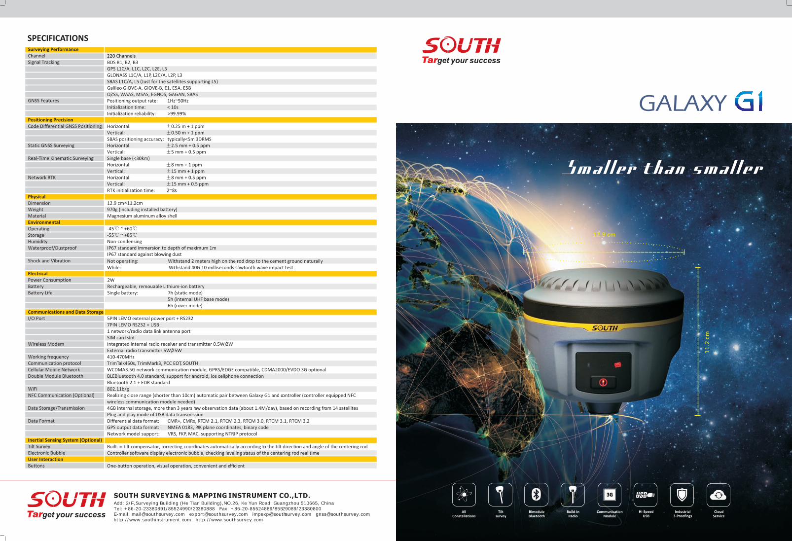
12.9 cm×11.2cm970g (including installed battery)Magnesium aluminum alloy shell
-45 ~ +60-55 ~ +85Non-condensingIP67 standard immersion to depth of maximum 1mIP67 standard against blowing dust
Not operating: Withstand 2 meters high on the rod drop to the cement ground naturallyWhile: Withstand 40G 10 milliseconds sawtooth wave impact test
2WRechargeable, remouable Lithium-ion batterySingle battery: 7h (static mode) 5h (internal UHF base mode) 6h (rover mode)
5PIN LEMO external power port + RS2327PIN LEMO RS232 + USB1 network/radio data link antenna portSIM card slotIntegrated internal radio receiver and transmitter 0.5W/2WExternal radio transmitter 5W/25W410-470MHzTrimTalk450s, TrimMark3, PCC EOT, SOUTHWCDMA3.5G network communication module, GPRS/EDGE compatible, CDMA2000/EVDO 3G optional BLEBluetooth 4.0 standard, support for android, ios cellphone connectionBluetooth 2.1 + EDR standard802.11b/gRealizing close range (shorter than 10cm) automatic pair between Galaxy G1 and controller (controller equipped NFC wireless communication module needed)4GB internal storage, more than 3 years raw observation data (about 1.4M/day), based on recording from 14 satellites Plug and play mode of USB data transmissionDifferential data format: CMR+, CMRx, RTCM 2.1, RTCM 2.3, RTCM 3.0, RTCM 3.1, RTCM 3.2GPS output data format: NMEA 0183, PJK plane coordinates, binary codeNetwork model support: VRS, FKP, MAC, supporting NTRIP protocol
Built-in tilt compensator, correcting coordinates automatically according to the tilt direction and angle of the centering rodController software display electronic bubble, checking leveling status of the centering rod real time
One-button operation, visual operation, convenient and efficient
Target your success
SOUTH SURVEYING & MAPPING INSTRUMENT CO.,LTD.Add: 2/F, Surveying Building (He Tian Building),NO.26, Ke Yun Road, Guangzhou 510665, China Tel: +86-20-23380891/85524990/23380888 Fax: +86-20-85524889/85529089/23380800 E-mail: [email protected] [email protected] [email protected] [email protected]://www.southinstrument.com http://www.southsurvey.com
AllConstellations
Tiltsurvey
BimoduleBluetooth
Build-InRadio
CommunicationModule
Hi-SpeedUSB
Industrial3-Proofings
CloudService
Smaller than smaller
11
.2 c
m
12.9 cm
GALAXY
Innovative structure designSOUTH Galaxy G1, with smaller size and innovative design, the weight is only 970g, is built with magnesium alloy materials. And the top edge is design to decrease harm for receiver in case of fall down to ground.
Full satellite constellations supportEquipped with most advanced GNSS boards, SOUTH Galaxy G1 system can track most signal from all kinds of running satellite constellation, especially support B1,B2 and B3 signal from , also is able to get position result with only BeiDou signal.
BeiDou
KEY FEATURES
TrimTalk450STrimMark3PCC EOTSOUTH
4G3G2G
Powerful new bluetooth moduleEquipped with bluetooth 4.0 module, which support receiver to work well with smartphone and tablet etc, also making bluetooth communication faster and more stable.
Tilt surveyThe internal Tilt sensor helps receiver to survey without centering, in order to improve survey efficiency, and tilt angle can reach 30 degree maximum.
Electronic bubble correctThe internal Electronic bubble sensor can correct the survey result, to support receiver to survey without leveling.
Intelligent and open platformAbased on smart platform and powerful structure, which can make system work faster and more stable, less power consumption, and can also monitor the status of each parts real time, extend battery life in the field.
Cloud service7*24 hour cloud service, which enable make service and support more quickly, such as online upgrade and register, remote diagnosis etc.
Advanced datalink moduleIntegrated with new and excellent datalink system, SOUTH Galaxy G1 is compatible with current radio protocols in the market, also supports all kinds of network types to access CORS seamlessly.
External radio transmitter (standard supply)Our high speed wireless digital radio is integrated with ten years radio design and production experience of SOUTH, adopting radio frequency and digital processing, baseband processing technology, air transmission rate reaches to 19200bp, radio-frequency emission power top to 25W, reliable performance, strong stability ,is more suitable for RTK fieldwork.
RTK carrying caseThe convenient RTK carrying case is customized for surveying workers, which adopts double oxford tabby textile fabric and YKK industrial grade waterproof zipper. It has strong abrasive resistance and waterproofness. Meanwhile the unique backpack design reduces the heavy burden of field work.
Surveying softwareGalaxy G1 RTK surveying system can equipped with SOUTH professional surveying software for special industries, such as engineering star, SurvCE, FieldGenius and so on.Engineering star (standard supply): it's our kernel surveying software, the main functions are detail survey, stake out point, stake out line, coordinate system transformation and so on. It's a powerful and efficient software for RTK survey.
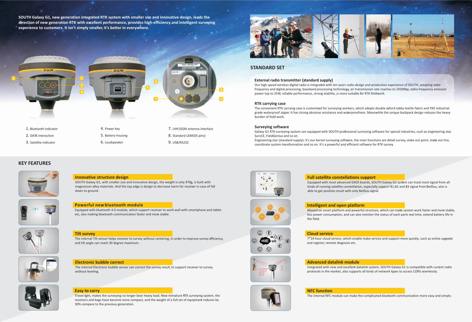
1. Bluetooth indicator
2. DATA interaction
3. Satellite indicator
7.
8.
UHF/GSM antenna interface
Standard LEMO(5 pins)
9. USB/RS232
SOUTH Galaxy G1, new generation integrated RTK system with smaller size and innovative design, leads the direction of new generation RTK with excellent performance, provides high-efficiency and intelligent surveying experience to customers. It isn't simply smaller, it's better in everywhere.
1 2
83
5
6
7
4
9
STANDARD SET
NFC function The internal NFC module can make the complicated bluetooth communication more easy and simple.
Easy to carryTravel light, makes the surveying no longer bear heavy load. New miniature RTK surveying system, the receivers and bags have become more compact, and the weight of a full set of equipment reduces by 30% compare to the previous generation.
4. Power key
5.
Loudspeaker
Battery housing
6.