Embed Size (px)
Citation preview
November, 2007
Gannawarra Shire Council
2120232A-RPT-001-A CS;mc
Gannawarra Urban and Rural Strategy Plan
Parsons Brinckerhoff Australia Pty Limited ACN 078 004 798 and Parsons Brinckerhoff International (Australia) Pty Limited ACN 006 475 056 trading as Parsons Brinckerhoff ABN 84 797 323 433
36 Wattle Street Bendigo VIC 3554 PO Box 2750 Bendigo VIC 3554 Australia Telephone +61 3 5441 6552 Facsimile +61 3 5441 6694 Email [email protected] ABN 84 797 323 433 NCSI Certified Quality System ISO 9001
Gannawarra Shire Urban and Rural Strategy Plan
© Parsons Brinckerhoff Australia Pty Limited and Parsons Brinckerhoff International (Australia) Pty Limited trading as Parsons Brinckerhoff (PB) [2007].
Copyright in the drawings, information and data recorded in this document (the information) is the property of PB. This document and the information are solely for the use of the authorised recipient and this document may not be used, copied or reproduced in whole or part for any purpose other than that for which it was supplied by PB. PB makes no representation, undertakes no duty and accepts no responsibility to any third party who may use or rely upon this document or the information.
Author: Carolyn Stephenson.....................................................................
Signed: ...........................................................
Reviewer: Andrew Butt..................................................................................
Signed: ................................................................
Approved by: Peter Doyle ..................................................................................
Signed: ................................................................................
Date: 13.11.2007 ...................................................................................
Distribution: Gannawarra Shire, C Stephenson, Library (MO7423) .................
Gannawarra Shire Urban and Rural Strategy Plan
PARSONS BRINCKERHOFF 2120232A-RPT-001-A Page i
Contents Page Number
1. Introduction..........................................................................................................................................1 1.1 Project Tasks 1 1.2 Gannawarra Shire 1 1.3 Regional Dynamics 3
2. Policy context.......................................................................................................................................5 2.1 State Planning Policy Framework (SPPF) 5 2.2 Minister’s Direction No. 6 – Rural Residential Development 6 2.3 Municipal Strategic Statement (MSS) 6 2.4 Murray River Regional Environmental Plan No 2 (REP2) of New South Wales 7 2.5 Development of land in flood prone areas 8 2.6 Changes to Rural Water in Gannawarra 8 2.7 Aboriginal Heritage Act 2006 8
3. Urban Rural Review...........................................................................................................................10 3.1 Housing Trends and Land Supply Issues in Gannawarra 10 3.2 Kerang 11
3.2.1 Existing Strategy 11 3.2.2 Land Audit 11 3.2.3 Demand and Supply Analysis 15 3.2.4 Strategy 20
3.3 Cohuna 24 3.3.1 Existing Strategy 24 3.3.2 Land Audit 24 3.3.3 Demand and Supply Analysis 27 3.3.4 Strategy 33
3.4 Murrabit 36 3.4.1 Existing Strategy 36 3.4.2 Land Audit 36 3.4.3 Demand and Supply Analysis 39 3.4.4 Strategy 40
3.5 Koondrook 44 3.5.1 Existing Strategy 44 3.5.2 Land Audit 45 3.5.3 Demand and Supply Analysis 48 3.5.4 Strategy 52
3.6 Macorna 54 3.6.1 Land Audit 54 3.6.2 Demand and Supply Analysis 55 3.6.3 Strategy 55
3.7 Other towns 55 4. Special Investigation Areas..............................................................................................................57
4.1 Kangaroo Lake/Lake Charm 57 4.1.1 Land Audit 57 4.1.2 Constraint definition 60 4.1.3 Strategy 61
4.2 Along the Gunbower Creek north and south east of Cohuna 64 4.2.1 Land Audit 64 4.2.2 Constraint definition 68 4.2.3 Strategy 70
4.3 Along the Murray River between Myall and Benjeroop 70 4.3.1 Land Audit 71 4.3.2 Constraint definition 74 4.3.3 Strategy 77
4.4 Reedy Lakes 77 4.4.1 Land Audit 77 4.4.2 Constraint definition 79 4.4.3 Strategy 80
Gannawarra Shire Urban and Rural Strategy Plan
PARSONS BRINCKERHOFF 2120232A-RPT-001-A Page ii
5. Tourism...............................................................................................................................................81
6. Conclusion .........................................................................................................................................82
Gannawarra Shire Urban and Rural Strategy Plan
PARSONS BRINCKERHOFF 2120232A-RPT-001-A Page iii
Executive Summary Gannawarra Shire Council engaged RMCG and PB to undertake this project as a result of considerable community interest in the options for further development of land in and around a number of towns and across the rural areas, particularly those close to water, for residential and for tourism purposes.
As a result of this project, Council aims to have a planning scheme that is able to accommodate demand for residential, rural residential and tourism development in a variety of attractive locations, without compromising their responsibilities to protect agriculture and environmental values and to provide infrastructure and services across the Shire.
The strategy developed directs demand for residential and rural residential development to existing settlements, to build upon these communities and offer attractive residential opportunities. Gannawarra Shire is facing challenges associated with a declining and aging population and substantial changes to agricultural practice which will affect settlement patterns. Council seeks to address population decline and support the ongoing viability of existing communities through offering opportunities for attractive residential development, based on one of the key assets of the municipality – water frontage. The Shire includes a number of lakes, as well as the Murray River and Gunbower Creek, and Council has experienced demand for development along and around these water bodies. This strategy seeks to guide this demand, offer a range of residential opportunities with water access and prevent unplanned and adhoc development.
The brief for the project directed consideration about residential, rural residential and tourism development to the following locations:
� Kerang
� Cohuna
� Murrabit
� Koondrook
� Macorna
� Kangaroo Lake/Lake Charm
� Along the Gunbower Creek north and south east of Cohuna
� Along the Murray River between Myall and Benjeroop
� Land to the east of the Reedy Lakes system
To determine the suitability of this land for land use change or development the review involved:
� An assessment of the policy environment
� An assessment of the suitability of the land for residential development, based on constraints such as effluent disposal capability, flood risk, water table depth and environmental values
� An assessment of demand and existing supply
Gannawarra Shire Urban and Rural Strategy Plan
PARSONS BRINCKERHOFF 2120232A-RPT-001-A Page iv
The review concluded that:
Kerang should remain a key growth area in the Shire, with its existing services and infrastructure. It has a sufficient supply of suitable land for medium density, conventional residential and low density residential growth for the short to medium term (up to 10 years). Growth beyond this time frame should be located to the south west of the existing urban area between the Murray Valley Highway and the Loddon River. A focus for new residential development in Kerang should be medium density housing within the existing urban area to accommodate the high proportion of older residents and smaller household sizes.
Cohuna also provides the opportunity for substantial residential growth in a well serviced town in an attractive setting on Gunbower Creek. It has a sufficient supply of suitable land for medium density and conventional residential growth for the long term (up to 20 years), but an area of low density residential growth should be provided to the north east of town, where it is accessible to the existing urban area and enjoys access to the Gunbower Creek. A focus for new residential development in Cohuna should also be medium density housing within the existing urban area to accommodate the high proportion of older residents and smaller household sizes.
Murrabit township and its immediate surrounds is a focus for small town residential opportunities close to the Murray River, subject to the provision of reticulated sewerage and selection of land with a lower flood risk. Rural living and low density residential growth is to build upon the existing urban area.
Koondrook also provides an ideal opportunity for attractive residential development close to the Murray River. It has sufficient land available within the town for conventional residential growth, although the extent to which some of this can be developed is constrained by poor drainage and flood risk. Some low density residential land in the south of the town has less flood risk and is suitable for a higher density of development. There is suitable land on the western side of town that can provide for residential and low density residential growth outside the flood plain. Some rural living can be supported in this area also.
Macorna is not considered suitable for residential growth due to its low capability for effluent disposal and limited services.
Kangaroo Lake and Lake Charm immediate surrounds should be the focus for lakeside development (low density residential and rural living) subject to the appropriate management of effluent, protection of adjoining farming activities, protection of environmental values and landscape, and access to infrastructure.
Reedy Lakes surrounds are not suited to residential growth due to isolation from existing settlements, flood risk, effluent disposal risk and environmental values.
Murray River (Myall to Benjeroop) area is not suited to extensive rural residential development due to its isolation from the main towns, agricultural and environmental values and flood risk. Rural residential development in this part of the Shire should be focussed around Murrabit.
Gunbower Creek (north and south of Cohuna) area has some potential for rural living and low density residential development close to Cohuna.
Tourism facilities in rural areas should be supported in the Shire where there is demonstrated need and market demand, where a rural location is required and where the proposal builds on and contributes to local attractions and the tourist economy. Additionally, these developments should only be considered where impact on agricultural activity is minimal, environmental values are protected, infrastructure and services are available and where waste water can be appropriately managed.
Gannawarra Shire Urban and Rural Strategy Plan
PARSONS BRINCKERHOFF 2120232A-RPT-001-A Page 1
1. Introduction Gannawarra Shire Council is seeking to capitalise on its unique attractions and offer high quality opportunities for residential and tourist development to maintain existing residents and attract new residents and visitors.
This planning project identifies options for these forms of land use, while ensuring that agricultural industries and opportunities are protected, environmental assets are preserved, the viability of existing settlements and tourist attractions is enhanced and Council is able to service such new development affordably.
The riverine and other water based environments of the Shire of Gannawarra are considered highly attractive by residents and visitors to the Shire. Council has identified that offering opportunities to live near or stay near such attractions has the potential to enhance the social and economic sustainability of the area
1.1 Project Tasks The Urban and Rural Strategy Plan project has three distinct tasks;
1. Prepare a Domestic Waste Water Management Plan (reported separately);
2. Review key towns and identify further development opportunities for each of these towns and their immediate surrounds. The project will provide Council with a long term framework for the sustainable development of urban and non urban areas and the application of zones and the subsequent development in these areas (included in this report);
3. Focus on four special investigation areas at Kangaroo Lake/Lake Charm, along the Gunbower Creek north and south east of Cohuna, along the Murray River between Myall and Benjeroop and land to the east of the Reedy Lakes system and identify any development opportunities in these areas (included in this report).
1.2 Gannawarra Shire Gannawarra Shire is located in northern Victoria and encompasses an area of 3732 sq. km. It is bounded by the Murray River to the north, and is largely characterised by its riverine environment, including the Murray River itself, surrounding flood plains, Gunbower Creek and numerous lakes and wetlands.
The Shire’s development was and still is based on agriculture, with two distinct areas and industry bases. Agriculture in the north and eastern parts of the municipality is based on irrigation, and agriculture in the southern and western areas is broadacre, dryland farming. Similar to other farming areas, agricultural industries are experiencing trends such as expansion and consolidation of properties and loss of water from irrigation properties, which pose questions about the future of agriculture in the area.
The towns of Gannawarra service the surrounding farming areas, and have provided for the development of some value adding industries. Tourism in the area has developed based on the riverine features and attractions.
Gannawarra Shire Urban and Rural Strategy Plan
PARSONS BRINCKERHOFF 2120232A-RPT-001-A Page 2
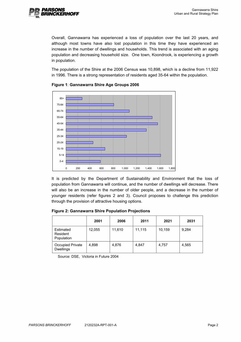
Overall, Gannawarra has experienced a loss of population over the last 20 years, and although most towns have also lost population in this time they have experienced an increase in the number of dwellings and households. This trend is associated with an aging population and decreasing household size. One town, Koondrook, is experiencing a growth in population.
The population of the Shire at the 2006 Census was 10,898, which is a decline from 11,922 in 1996. There is a strong representation of residents aged 35-64 within the population.
Figure 1: Gannawarra Shire Age Groups 2006
0 200 400 600 800 1,000 1,200 1,400 1,600 1,800
0-4
5-14
15-19
20-24
25-34
35-44
45-54
55-64
65-74
75-84
85+
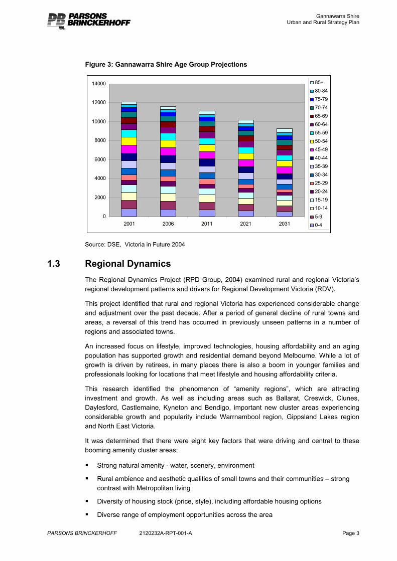
It is predicted by the Department of Sustainability and Environment that the loss of population from Gannawarra will continue, and the number of dwellings will decrease. There will also be an increase in the number of older people, and a decrease in the number of younger residents (refer figures 2 and 3). Council proposes to challenge this prediction through the provision of attractive housing options.
Figure 2: Gannawarra Shire Population Projections
2001 2006 2011 2021 2031
Estimated Resident Population
12,055 11,610 11,115 10,159 9,284
Occupied Private Dwellings
4,898 4,876 4,847 4,757 4,565
Source: DSE, Victoria in Future 2004
Gannawarra Shire Urban and Rural Strategy Plan
PARSONS BRINCKERHOFF 2120232A-RPT-001-A Page 3
Figure 3: Gannawarra Shire Age Group Projections
0
2000
4000
6000
8000
10000
12000
14000
2001 2006 2011 2021 2031
85+80-8475-7970-7465-6960-6455-5950-5445-4940-4435-3930-3425-2920-2415-1910-145-90-4
Source: DSE, Victoria in Future 2004
1.3 Regional Dynamics The Regional Dynamics Project (RPD Group, 2004) examined rural and regional Victoria’s regional development patterns and drivers for Regional Development Victoria (RDV).
This project identified that rural and regional Victoria has experienced considerable change and adjustment over the past decade. After a period of general decline of rural towns and areas, a reversal of this trend has occurred in previously unseen patterns in a number of regions and associated towns.
An increased focus on lifestyle, improved technologies, housing affordability and an aging population has supported growth and residential demand beyond Melbourne. While a lot of growth is driven by retirees, in many places there is also a boom in younger families and professionals looking for locations that meet lifestyle and housing affordability criteria.
This research identified the phenomenon of “amenity regions”, which are attracting investment and growth. As well as including areas such as Ballarat, Creswick, Clunes, Daylesford, Castlemaine, Kyneton and Bendigo, important new cluster areas experiencing considerable growth and popularity include Warrnambool region, Gippsland Lakes region and North East Victoria.
It was determined that there were eight key factors that were driving and central to these booming amenity cluster areas;
� Strong natural amenity - water, scenery, environment
� Rural ambience and aesthetic qualities of small towns and their communities – strong contrast with Metropolitan living
� Diversity of housing stock (price, style), including affordable housing options
� Diverse range of employment opportunities across the area
Gannawarra Shire Urban and Rural Strategy Plan
PARSONS BRINCKERHOFF 2120232A-RPT-001-A Page 4
� Rising home values (investment is seen to provide a return)
� Quality and secure facilities in health and education
� Existing or future retirement lifestyle qualities
� Good, improving transport links to Melbourne
This research provides an understanding of the package of attributes required to support population growth and insight into the opportunities for growth stimulation that may lie in Gannawarra Shire. Although Gannawarra Shire is more isolated than the above identified regions, it is able to offer strong natural amenity and a number of the other above attributes. Council believes that they are currently, and can continue to, attract growth because of this.
Gannawarra Shire Urban and Rural Strategy Plan
PARSONS BRINCKERHOFF 2120232A-RPT-001-A Page 5
2. Policy context
2.1 State Planning Policy Framework (SPPF) The SPPF provides the policy context for understanding the suitability of options for new residential and tourism development.
In summary, this framework identifies that:
� Council has a responsibility to provide a suitable supply of land for residential development that meets the needs of its community
� Council has a responsibility to protect the environmental resources and assets of the area, including water quality, habitat, native vegetation and biodiversity
� Council has a responsibility to protect residents from hazards such as flooding and to protect flood plains for the function of the storage and passage of flood waters
� Council has a responsibility to provide for a supply of housing that is energy efficient, accessible and offers a diversity of choice
� Council has a responsibility to plan its urban areas so they are efficient, compact, consolidated and exhibit a high quality of urban design
� Council has a responsibility to protect the State’s agricultural base from the unplanned loss of productive agricultural land due to permanent changes of land use of productive farmland which is of strategic significance in the local or regional context
� Council has a responsibility to provide for the provision of infrastructure in an efficient, economic and equitable manner and
� Council has a responsibility to foster economic growth and development.
In terms of residential land supply, the SPPF identifies that Council should plan to accommodate projected population growth over at least a 10 year period. It also identifies that land should only be zoned for rural living or rural residential development where it:
� is located close to existing towns and urban centres, but not in areas that will be required for fully serviced urban development
� can be supplied with electricity and water and good quality road access
� will not encroach on high quality productive agricultural land or adversely impact on waterways or other natural resources
The SPPF states that Council should also encourage the development of a range of well designed and sited tourist facilities, including integrated resorts, motel accommodation and smaller scale operations such as host farm, bed and breakfast and retail opportunities. Facilities should have access to suitable transport and be compatible with and build upon the assets and qualities of surrounding urban or rural activities and cultural and natural attractions.
Gannawarra Shire Urban and Rural Strategy Plan
PARSONS BRINCKERHOFF 2120232A-RPT-001-A Page 6
2.2 Minister’s Direction No. 6 – Rural Residential Development In determining the provision of land for rural residential development, Council must also have regard for Minister’s Direction No. 6. The objective of Minister’s Direction No. 6 is to manage the provision of sustainable rural residential development so that it supports sustainable housing and settlements and does not compromise Victoria’s agricultural, natural, environmental, landscape and infrastructure resources.
Minister’s Direction No 6 requires a planning authority to demonstrate that proposed rural residential development:
� is consistent with the housing needs and settlement strategy of the area
� is supported by and supports sustainable and viable settlements and communities
� does not compromise the sustainable future use of existing natural resources, including productive agricultural land, water, mineral and energy resources
� protects existing visual and environmental qualities of the area, such as landscape, water quality, native vegetation, habitat and biodiversity values
� avoids predictable adverse environmental processes and effects, such as flooding, erosion, landslip, salinity or wildfire
� can efficiently be serviced by social and physical infrastructure, at an acceptable and sustainable community cost.
The Rural Residential Development Guidelines (DSE, 2006) have been developed to assist with the implementation of Minister’s Direction No. 6.
According to these guidelines rural residential development refers to land in a rural setting, used and developed for dwellings that are not primarily associated with agriculture. Some agriculture may take place on the land, however, it will be ancillary to the dwelling. It generally relates to lots of up to 8ha (20acres), but size is not considered a relevant trigger as land larger than this can be used for rural residential purposes, and land smaller than this can be used for small lot agriculture (fruit, flowers, grapes, olives).
2.3 Municipal Strategic Statement (MSS) The Gannawarra MSS is the existing local policy document to guide growth and development in the municipality. This policy document sits within the Gannawarra Planning Scheme and notes that further work is required to plan and manage residential and tourism growth and development within the municipality.
The MSS identifies that the strategy for the Shire includes to:
� support growth and development of the agricultural sector
� encourage value adding industries
� protect and improve the condition of the natural environment
� grow and consolidate existing towns
� further develop the local tourism industry based on existing features and assets
� maintain and enhance existing infrastructure.
In particular, it states the Council planning objective for Residential (Clause 21.04-3) is:
Gannawarra Shire Urban and Rural Strategy Plan
PARSONS BRINCKERHOFF 2120232A-RPT-001-A Page 7
� to encourage infill residential development in areas that is not affected by environmental hazards to maximise the use of existing infrastructure.
The MSS nominates a number of strategies by which this objective should be achieved. Those particularly relevant to this study are:
� consolidate urban areas within Kerang, Cohuna and Koondrook to ensure cost efficient supply of services and good access to urban facilities
� consolidate future urban development in Kerang, Cohuna, Koondrook and Leitchville within defined township boundaries to maximise efficiency for reticulated sewerage systems
� promote new urban development in Kerang, Cohuna and Koondrook that is located to protect good quality agricultural land, utilise existing infrastructure and recognise physical and environmental constraints to development
� low density residential development in Kerang, Cohuna and Koondrook should be located at the edge of or within townships where future fully serviced township growth will not be prejudiced, where reticulated water and power are available, and where domestic effluent can be disposed of by reticulated sewerage or other approved treatment
� provide a range of residential options in all urban centres to accommodate housing choice, and the needs of tourists, retirees and elderly people
� ensure that new residential areas are designed to maximise solar efficiency, provide for a variety of lot sizes, have full reticulation of services, make available adequate water for fire fighting and access for fire trucks, retain remnant vegetation and ensure universal access.
2.4 Murray River Regional Environmental Plan No 2 (REP2) of New South Wales The Murray River REP also must be considered when determining the future of land along the Murray River.
Key directions of this REP are:
� maintaining public access to the River
� protection of the riverine landscape and natural values and processes
� minimising development immediately adjacent to the River
� minimising development in and changes to flood prone areas
� new or expanding settlements (including rural-residential subdivision, tourism and recreational development) should be located:
a. on flood free land,
b. close to existing services and facilities, and
c. on land that does not compromise the potential of prime crop and pasture land to produce food or fibre.
Gannawarra Shire Urban and Rural Strategy Plan
PARSONS BRINCKERHOFF 2120232A-RPT-001-A Page 8
2.5 Development of land in flood prone areas A key issue in planning for growth and development in Gannawarra Shire is flooding. A considerable part of the Shire is flood prone to varying degrees.
The North Central Catchment Management Authority is responsible for flood mapping and flood plain management within the Shire.
Various controls and legislation apply to or are triggered by flood prone land and will influence the ability to develop in the area.
Rural Floodway Overlay: This control is part of the Gannawarra Planning Scheme and applies to the main flood ways. Generally these areas should remain free from development to maintain the free passage of floodwaters and to prevent people and property from being exposed to risk from flooding.
Land Subject to Inundation Overlay: This control is part of the Gannawarra Planning Scheme and applies to the full extent of the 1 in 100 year floodplain. Any development within these areas must be assessed for its likely impact on the passage of flood waters and water quality and for the potential risk to residents and property.
Building Act: Under building regulations, the floor level of a dwelling must be 300mm above the 1 in 100 year flood level.
Septic Tank Code of Practice: septic tanks are discouraged from flood prone land. Even systems that treat water to a standard suitable for reuse are of concern within a floodplain as during a flood event the components of the system that include untreated effluent will become inundated and pose a pollution threat. The likelihood of a domestic wastewater treatment facility being approved in a flood prone area will depend on flood frequency and flood depth.
2.6 Changes to Rural Water in Gannawarra Although not central to this project, an important issue facing Gannawarra Shire and its residents is the changes to rural water management and availability, in particular, irrigation water management.
The changes to water management in the Shire may change the amount of water or the level of water in a number of the water bodies that are included in this review. This may affect their viability and amenity as a residential or tourist location. The availability of water for agriculture and for rural dwellings will also impact on the prospects for some areas. These changes are not yet fully determined and as such cannot be considered as a part of this review.
Influences on the ongoing availability of rural water in the Shire include climate change, the Living Murray Initiative, the State Government’s White Paper on water reform, water trading (including unbundling), reconfiguration and the Federal Government Water Plan.
2.7 Aboriginal Heritage Act 2006 The Aboriginal Heritage Act 2006 and regulations came into effect on 28 May 2007 and replace the Archaeological and Aboriginal Relics Preservation Act 1972 and Part IIA of the Aboriginal and Torres Strait Islander Heritage Protection Act 1984.
Gannawarra Shire Urban and Rural Strategy Plan
PARSONS BRINCKERHOFF 2120232A-RPT-001-A Page 9
A key objective of the Aboriginal Heritage Act 2006 is to recognise, protect and conserve Aboriginal cultural heritage in Victoria. It establishes a consistent approach to identifying and managing potential impacts of development on Aboriginal heritage.
This legislation is of particular relevance to this project and to Gannawarra Shire. It identifies a range of sensitive environments (Areas of Cultural Heritage Sensitivity) and high impact activities which trigger the requirement for a Cultural Heritage Management Plan.
Areas of Cultural Heritage Sensitivity include lunettes and land in and around waterways and Ramsar wetlands. There are many of these places in Gannawarra, and many of the places subject to this review include Areas of Cultural Heritage Sensitivity. Subdivision of land into three or more lots and development of land for three or more dwellings are considered to be High Impact Activities. The combination of a High Impact Activity in an area of Cultural Heritage Sensitivity triggers the need for a Cultural Heritage Management Plan.
A Cultural Heritage Management Plan is required as a part of the planning permit process, and provides for the assessment and management of impact of development on Aboriginal heritage. The aim of the Cultural Heritage Management Plan is to minimise impact. The Cultural Heritage Management Plan process provides for the involvement of relevant Aboriginal groups (Registered Aboriginal Party or Parties) in the assessment of the proposal.
Any development that may arise from the recommendations of this study is likely to require a Cultural Heritage Management Plan.
Gannawarra Shire Urban and Rural Strategy Plan
PARSONS BRINCKERHOFF 2120232A-RPT-001-A Page 10
3. Urban Rural Review The Urban Rural Review component of this project relates to the study of the opportunities for residential and rural residential growth of some of the towns of the Gannawarra Shire.
The project brief states that “the planning scheme review highlighted Council has experienced a significant increase in interest for the future development of some of its larger towns such as Kerang, Cohuna and Koondrook. There is a general perception that supply of well located and serviceable residential and rural residential land is not sufficient to meet demand. Council is keen to address this situation and provide an equitable and balanced approach to development opportunities across these towns.”
The Urban Rural Review focuses on the following towns and their immediate surrounds:
� Kerang
� Cohuna
� Murrabit
� Koondrook
� Macorna
The tasks required for this part of the project include;
1. Review of existing background material that relates to existing conditions;
2. Undertake a land audit based on existing conditions;
3. Analyse residential land supply and demand following an assessment of population trends and drivers;
4. Develop a strategic case for any changes or otherwise.
3.1 Housing Trends and Land Supply Issues in Gannawarra The characteristics of development in Gannawarra are driven by a range of social and demographic trends, including farm restructure, an ageing population, lifestyle opportunities in the River Murray corridor and the formation of generally smaller households in urban and rural areas. Overall however, patterns of change are distinctly modest in nature, with few new houses being constructed, and many places with stable or declining populations even as household numbers increase.
Measuring the trends and subsequent demand for new housing has its limitations in small towns where trends and cycles are fragmented or “lumpy” in nature - presenting challenges to forecasting. Consequently, this document takes data from various sources, both quantitative and qualitative, and reflects the following general observations:
� Household growth (and housing growth) has increased more than population growth in each of Gannawarra’s larger towns.
� Existing land supply (through zoning) provides opportunities to meet anticipated demand, but the nature of topography and other site limitations exist in many situations.
Gannawarra Shire Urban and Rural Strategy Plan
PARSONS BRINCKERHOFF 2120232A-RPT-001-A Page 11
� Evidence of some ‘latent’ demand for small block rural housing on the fringe of towns and in other landscapes can be reflected in ways that do not present risks to continuing agriculture and land and water resource values.
The data used in these descriptions is drawn from a variety of sources. Census material from 1981 to 2006 is analysed. Additional information has been drawn from Council building and planning datasets and discussion with Council staff and local property industry professionals.
3.2 Kerang Kerang performs an important regional and community role as a centre for shopping, employment and business services. Kerang has excellent facilities and living environment for retirees and is a focus for tourist and recreation attractions in the region. Increasingly Kerang is being recognised as a centre for land management expertise and education1. It is the largest population centre in the Shire with a population of 3,672 at the 2006 Census.2
The majority of the Kerang urban area is zoned Residential 1 and provides for conventional residential development. There are some areas of Low Density Residential zoned land and associated development around the fringe of the town. The main low density residential area is to the south east of town.
3.2.1 Existing Strategy
The current strategy for residential development in Kerang is;
� Future serviced residential development (10 to 15 years) is to be encouraged in the north and south of the urban area at locations identified in the Structure Plan and by consolidation of areas within the existing township.
� Future low density residential development will be confined (in the next 10 to 15 years) to already zoned land and the locations identified in the Kerang Structure Plan.
� Well-designed medium density housing development is to be encouraged.
3.2.2 Land Audit
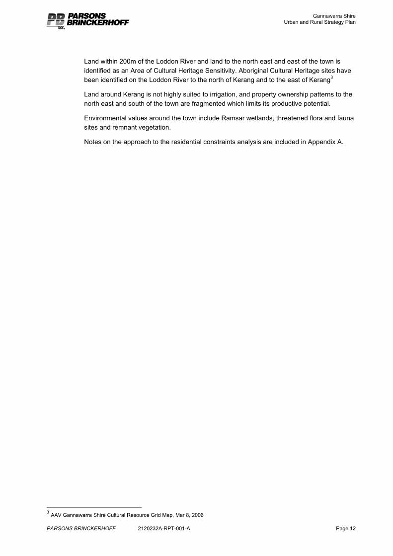
Constraints and opportunities for residential and rural residential growth in and around Kerang include the Loddon River and associated swamps and wetlands, related issues of flooding and poor drainage, soils that are not conducive to on-site’ effluent disposal, high water table, remnant vegetation and habitat and the local airport (to the south east of the town) and wastewater treatment plant (to the east of the town).
Residential development in Kerang is highly constrained beyond the existing urban area due to flood risk. A significant flood levee encircles the town and flood risk is extensive beyond this.
Some of this risk could be managed through the extension of the reticulated sewer for wastewater disposal and through elevated floor levels. Development within highly constrained areas, however, will be associated with greater restriction and most likely higher development cost.
1 Gannawarra MSS – Clause 21.04 2 Census 2006 First Release - Place of Usual Residence data.
Gannawarra Shire Urban and Rural Strategy Plan
PARSONS BRINCKERHOFF 2120232A-RPT-001-A Page 12
Land within 200m of the Loddon River and land to the north east and east of the town is identified as an Area of Cultural Heritage Sensitivity. Aboriginal Cultural Heritage sites have been identified on the Loddon River to the north of Kerang and to the east of Kerang3
Land around Kerang is not highly suited to irrigation, and property ownership patterns to the north east and south of the town are fragmented which limits its productive potential.
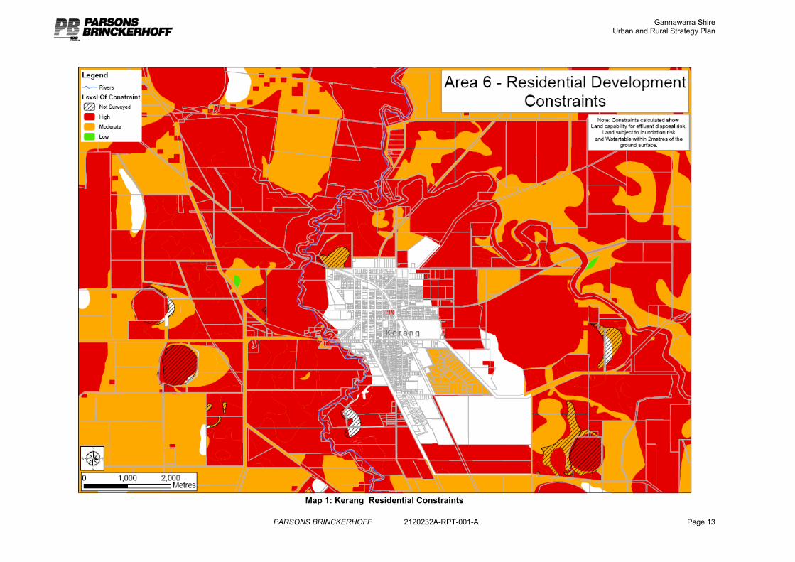
Environmental values around the town include Ramsar wetlands, threatened flora and fauna sites and remnant vegetation.
Notes on the approach to the residential constraints analysis are included in Appendix A.
3 AAV Gannawarra Shire Cultural Resource Grid Map, Mar 8, 2006
Gannawarra Shire Urban and Rural Strategy Plan
PARSONS BRINCKERHOFF 2120232A-RPT-001-A Page 13
Map 1: Kerang Residential Constraints
Gannawarra Shire Urban and Rural Strategy Plan
PARSONS BRINCKERHOFF 2120232A-RPT-001-A Page 14
Map 2: Kerang Environmental Features
Gannawarra Shire Urban and Rural Strategy Plan
PARSONS BRINCKERHOFF 2120232A-RPT-001-A Page 15
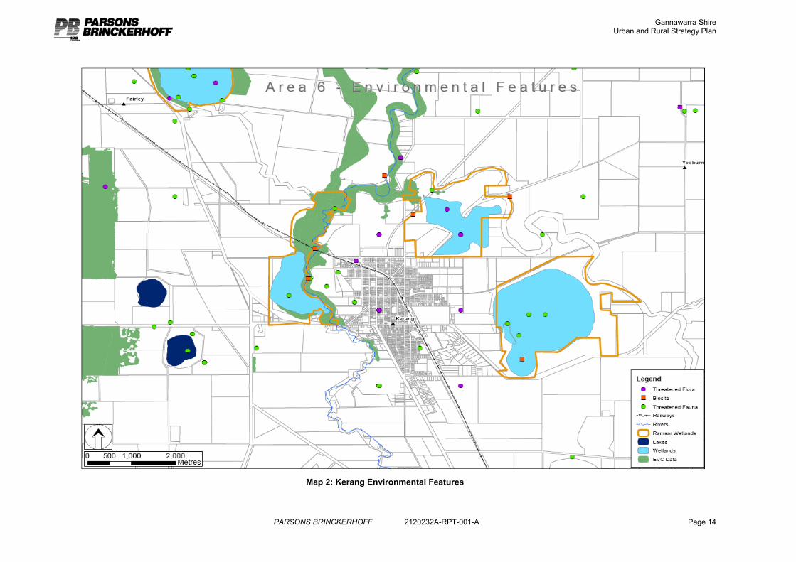
3.2.3 Demand and Supply Analysis
Demand The ongoing demand for residential and rural residential land is dependant on population trends such as population growth, age structure, number of households and household size.
Although Kerang has experienced a decline in population since 1981, there has been a growth in households and dwellings. This is attributed to the aging population, with consequent smaller households, and new housing supply should respond to this population trend.
Figure 4: Kerang Population
1981 1986 1991 1996 2001 2006 Total population 4,049 4,031 4,024 3,883 3,719 3,672
Total households 1,342 1,412 1,470 1,498 1,534 1,534
Average household Size
3.0 2.9 2.7 2.6 2.4
2.3
Kerang has experienced a loss of 347 people over the 25 year period 1981 to 2006 (annual average change of -0.4%), although the rate of population loss has decreased between 2001 and 2006 (annual average change of -0.3%). Importantly, household numbers have increased since 1981 and remained relatively stable between 2001 and 2006.
Of this declining population, an increased proportion and number are aged over 60. In 1981 19.1% of the population were aged over 60 compared to 28.1% in 2001. In 2006, the proportion of the population over 60 was 22%.
These trends suggest a slight stabilisation of the aging of the Kerang population.
Figure 5: Kerang Age Distribution 2006
0 100 200 300 400 500 600
0-4
5-14
15-19
20-24
25-34
35-44
45-54
55-64
65-74
75-84
85+
Gannawarra Shire Urban and Rural Strategy Plan
PARSONS BRINCKERHOFF 2120232A-RPT-001-A Page 16
Figure 6: Kerang Household Size
0
200
400
600
800
1000
1200
1400
1600
1800
1981 1986 1991 1996 2001 2006
5 or more persons4 persons3 persons2 persons1 person
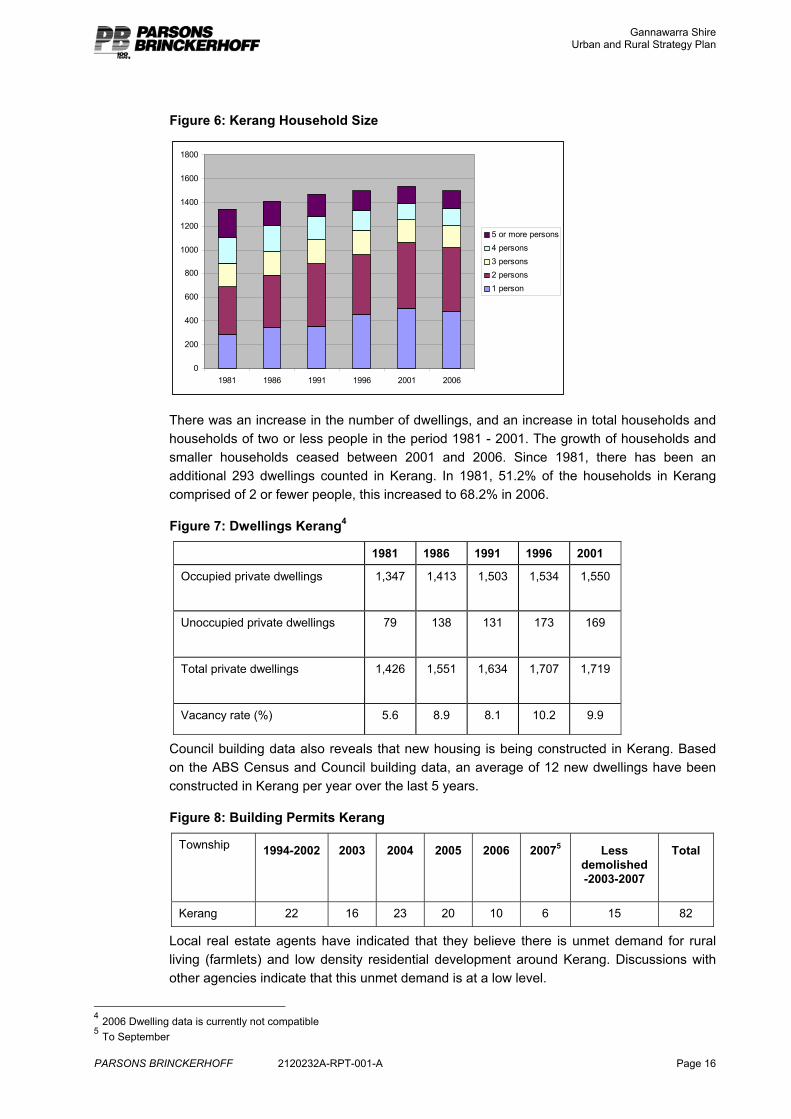
There was an increase in the number of dwellings, and an increase in total households and households of two or less people in the period 1981 - 2001. The growth of households and smaller households ceased between 2001 and 2006. Since 1981, there has been an additional 293 dwellings counted in Kerang. In 1981, 51.2% of the households in Kerang comprised of 2 or fewer people, this increased to 68.2% in 2006.
Figure 7: Dwellings Kerang4
1981 1986 1991 1996 2001
Occupied private dwellings 1,347 1,413 1,503 1,534 1,550
Unoccupied private dwellings 79 138 131 173 169
Total private dwellings 1,426 1,551 1,634 1,707 1,719
Vacancy rate (%) 5.6 8.9 8.1 10.2 9.9
Council building data also reveals that new housing is being constructed in Kerang. Based on the ABS Census and Council building data, an average of 12 new dwellings have been constructed in Kerang per year over the last 5 years.
Figure 8: Building Permits Kerang
Township 1994-2002 2003 2004 2005 2006 20075 Less demolished -2003-2007
Total
Kerang 22 16 23 20 10 6 15 82
Local real estate agents have indicated that they believe there is unmet demand for rural living (farmlets) and low density residential development around Kerang. Discussions with other agencies indicate that this unmet demand is at a low level.
4 2006 Dwelling data is currently not compatible 5 To September
Gannawarra Shire Urban and Rural Strategy Plan
PARSONS BRINCKERHOFF 2120232A-RPT-001-A Page 17
Analysis of population and building data for Kerang has indicated that there is demand for new dwellings. Based on population trends, a focus for new housing development should be smaller houses and units suited to an aging population, preferably located close to shops and other town services. In the longer term, the aging population may lead to a decline in the demand for new dwellings in Kerang.
The following table provides an estimate of the ongoing demand for dwellings within Kerang, based on the above trends. It is based on the assumption of an average of 10 dwellings constructed per year, with half being conventional sized dwellings, a quarter being units and a quarter being low density residential developments. The assumption of demand for dwelling size is not based on any data as this is not available, rather it is based on anecdotal evidence of community preferences. For example, there are currently at least 6 to 8 new units in Kerang up to 18 months old that remain unsold.
Figure 9: Kerang Estimated Residential Dwelling and Land Demand
10 year demand 20 year demand
Dwellings Approximate land area
(residential lots only)
Dwellings Approximate land area
(residential lots only)
Conventional dwellings (avg. lot size 1000m2)
50
5ha 100 10ha
Units (medium density avg. lot size 500m2)
25 1.25ha 50 2.5ha
Low density residential (avg. lot size 4000m2)
25
10ha 50 20ha
100 16.25ha 200 32.5ha
Supply Residential 1 Zone (R1Z): There are a number of large parcels of vacant R1Z land on the north east fringe of Kerang. This land has a lower level of amenity and is relatively isolated from the town centre, and as such has not been taken up for development.
Gannawarra Shire Urban and Rural Strategy Plan
PARSONS BRINCKERHOFF 2120232A-RPT-001-A Page 18
Map 3: Kerang Residential Development
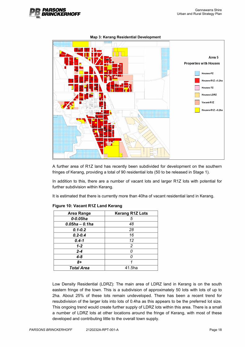
A further area of R1Z land has recently been subdivided for development on the southern fringes of Kerang, providing a total of 90 residential lots (50 to be released in Stage 1).
In addition to this, there are a number of vacant lots and larger R1Z lots with potential for further subdivision within Kerang.
It is estimated that there is currently more than 40ha of vacant residential land in Kerang.
Figure 10: Vacant R1Z Land Kerang
Area Range Kerang R1Z Lots 0-0.05ha 5
0.05ha – 0.1ha 48 0.1-0.2 28 0.2-0.4 16 0.4-1 12 1-2 2 2-4 0 4-8 0 8+ 1
Total Area 41.5ha
Low Density Residential (LDRZ): The main area of LDRZ land in Kerang is on the south eastern fringe of the town. This is a subdivision of approximately 50 lots with lots of up to 2ha. About 25% of these lots remain undeveloped. There has been a recent trend for resubdivision of the larger lots into lots of 0.4ha as this appears to be the preferred lot size. This ongoing trend would create further supply of LDRZ lots within this area. There is a small a number of LDRZ lots at other locations around the fringe of Kerang, with most of these developed and contributing little to the overall town supply.
Gannawarra Shire Urban and Rural Strategy Plan
PARSONS BRINCKERHOFF 2120232A-RPT-001-A Page 19
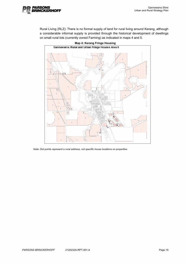
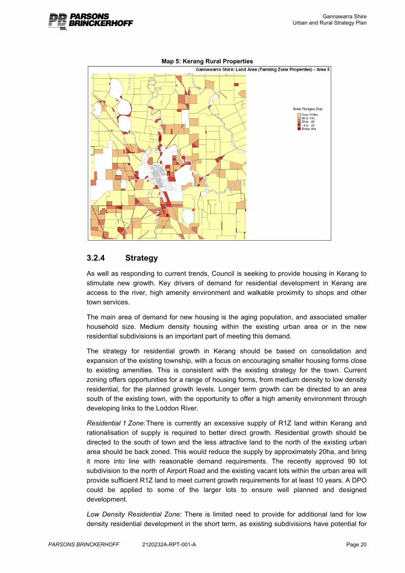
Rural Living (RLZ): There is no formal supply of land for rural living around Kerang, although a considerable informal supply is provided through the historical development of dwellings on small rural lots (currently zoned Farming) as indicated in maps 4 and 5.
Map 4: Kerang Fringe Housing
Note: Dot points represent a rural address, not specific house locations on properties
Gannawarra Shire Urban and Rural Strategy Plan
PARSONS BRINCKERHOFF 2120232A-RPT-001-A Page 20
Map 5: Kerang Rural Properties
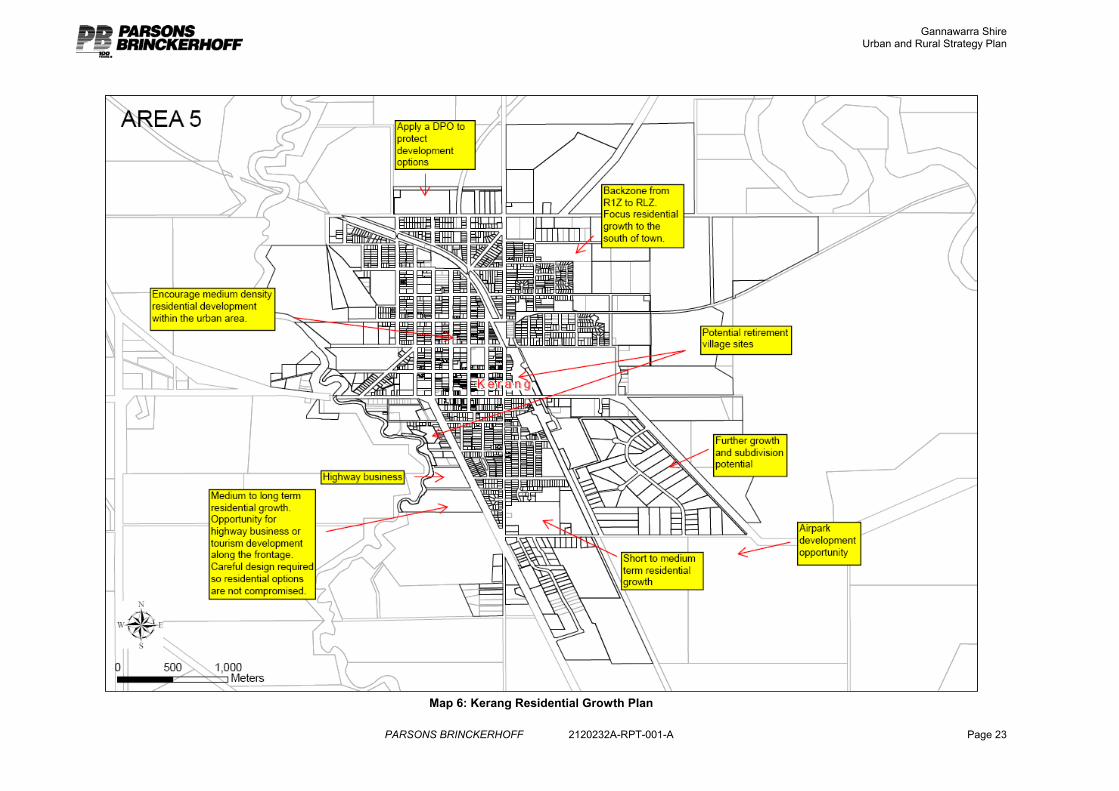
3.2.4 Strategy
As well as responding to current trends, Council is seeking to provide housing in Kerang to stimulate new growth. Key drivers of demand for residential development in Kerang are access to the river, high amenity environment and walkable proximity to shops and other town services.
The main area of demand for new housing is the aging population, and associated smaller household size. Medium density housing within the existing urban area or in the new residential subdivisions is an important part of meeting this demand.
The strategy for residential growth in Kerang should be based on consolidation and expansion of the existing township, with a focus on encouraging smaller housing forms close to existing amenities. This is consistent with the existing strategy for the town. Current zoning offers opportunities for a range of housing forms, from medium density to low density residential, for the planned growth levels. Longer term growth can be directed to an area south of the existing town, with the opportunity to offer a high amenity environment through developing links to the Loddon River.
Residential 1 Zone: There is currently an excessive supply of R1Z land within Kerang and rationalisation of supply is required to better direct growth. Residential growth should be directed to the south of town and the less attractive land to the north of the existing urban area should be back zoned. This would reduce the supply by approximately 20ha, and bring it more into line with reasonable demand requirements. The recently approved 90 lot subdivision to the north of Airport Road and the existing vacant lots within the urban area will provide sufficient R1Z land to meet current growth requirements for at least 10 years. A DPO could be applied to some of the larger lots to ensure well planned and designed development.
Low Density Residential Zone: There is limited need to provide for additional land for low density residential development in the short term, as existing subdivisions have potential for
Gannawarra Shire Urban and Rural Strategy Plan
PARSONS BRINCKERHOFF 2120232A-RPT-001-A Page 21
growth. There are approximately 25 vacant LDRZ lots in Kerang, in addition to at least 10 with further subdivision potential (subject to appropriate effluent disposal options). Most of this growth can occur in the Golf Links development. This current supply is satisfactory for 10 years demand. A small additional supply could be provided on the airport land (subject to an analysis of demand) for a specialist market associated with aircraft owners.
Rural Living Zone: The extensive flooding around Kerang severely limits the opportunity for providing land for rural residential development. Pursuant to Minister’s Direction Number 6 land with environmental constraints such as extensive flooding is generally not suitable for rural living purposes. The flooding risk of this area imposes constraints with respect to domestic effluent disposal, building approval for dwellings and the provision of safe all weather access. Anecdotal evidence has also indicated that there is a low level of demand for rural living around Kerang. A small level of supply can be provided through the back zoning of residentially zoned land to the north of town to Rural Living. This back zoning will act to consolidate residential growth to the south, provide a small level of supply of rural living land at Kerang as well as provide for a buffer between the farming area and the residential area. This land is flood free. A lot size in the vicinity of 2ha is considered to be appropriate to local market demands and will provide for sustainable effluent management.
Business Zone: Council is proposing to extend its business zonings along the Murray Valley Highway on the southern approach to Kerang. This is a reasonable strategy given the highway frontage, and the site is within the urban area. Any development on these sites should be carefully designed so as to not compromise the amenity of the area, given the below strategy of offering opportunities for residential development in this area also.
Future Options: Land located to the south of Kerang, between the Loddon River and the Murray Valley Highway is an ideal site for future residential development, as it offers an attractive location with river access but flood protection. Alternative development fronts around Kerang are limited by flooding, the waste water treatment facility to the north east and the airport to the south east. The northern most lot of this property is approximately 10ha, but there is considerable additional land (at least 40ha) to the south of this for expansion. Although is it rated highly constrained on the capability maps, its capability would significantly improve with service by sewer. The area is identified as an area of Cultural Heritage Sensitivity, but any sites are likely to be limited to land along the river as this property has been extensively modified for agriculture. The property also has limited productive agricultural potential due to soil type and property fragmentation to the south, and although the site has some environmental values (small area of remnant vegetation on the river and a threatened fauna site), these are considered manageable through sensitive design.
This area provides the opportunity for residential development that has access to both the river and the existing urban area and its services. Development options on the site could include a range of lot sizes, from medium density to low density residential, with the development to be fully serviced and designed to embrace links to the river. Development of the site could also include tourist accommodation. Subdivision must be designed so as to promote access to the Loddon River and also to have a separating landscaped buffer from the highway business area. Development of this site must be carefully designed to ensure it is integrated into the existing urban area. Such integration should include visual and physical links to the existing residential area to the north and east. Walking links to shops and services in the centre of Kerang should be developed. The existing levee offers an opportunity for a walking track. A Development Plan should be prepared for this area to

Gannawarra Shire Urban and Rural Strategy Plan
PARSONS BRINCKERHOFF 2120232A-RPT-001-A Page 22
coordinate opportunities for commercial and residential development, and address the need for integration with the existing urban area and promotion of the Loddon River access.
Gannawarra Shire Urban and Rural Strategy Plan
PARSONS BRINCKERHOFF 2120232A-RPT-001-A Page 23
Map 6: Kerang Residential Growth Plan
Gannawarra Shire Urban and Rural Strategy Plan
PARSONS BRINCKERHOFF 2120232A-RPT-001-A Page 24
3.3 Cohuna Cohuna, located on the Murray Valley Highway, performs a service centre role similar to that of Kerang for the south eastern half of the Shire. It provides a district centre for shopping, employment and business services, is a town well suited to retirement and rural retreats, and is a gateway to the Gunbower State Forest6. It is the second largest population centre with a population of 1,816 at the 2006 Census. Much of the town is zoned Residential 1 to provide for residential development. There is land zoned Low Density Residential to the west of Cohuna, and to the north around the golf course.
3.3.1 Existing Strategy
The current strategy for residential development in Cohuna is;
� Development of the urban area, which supports and promotes Cohuna’s district centre and retirement role will be encouraged.
� Future low density residential development (in the next 10 to 15 years) is to be encouraged at existing locations identified in the Cohuna Structure Plan.
� Well-designed medium density housing development is to be encouraged.
3.3.2 Land Audit
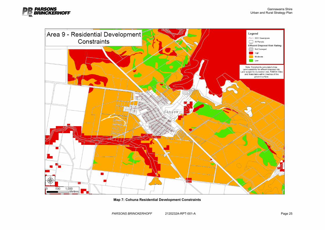
Cohuna has a lower level of constraint to growth as flooding is largely limited to the north east side of the Gunbower Creek.
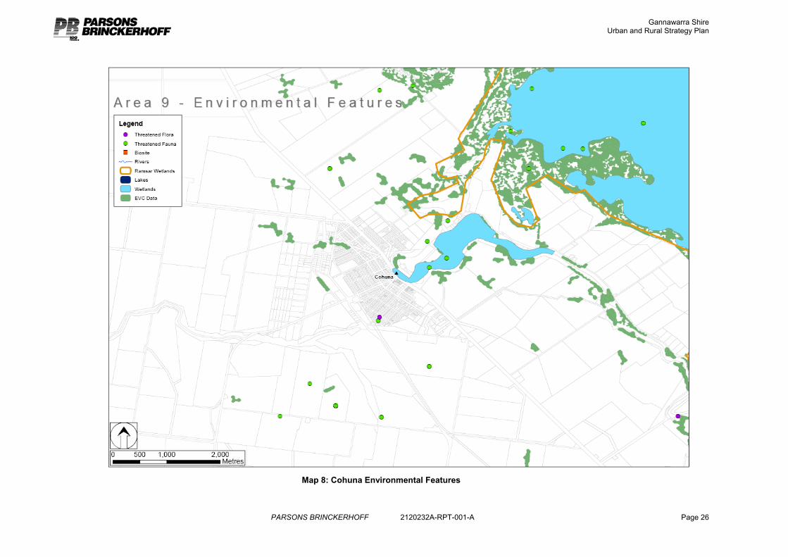
Land within 200m of the Gunbower Creek and within 200m of the Gunbower State Forest are Areas of Cultural Heritage Sensitivity. Aboriginal Cultural Heritage sites have been identified around Cohuna township7.
Land immediately around Cohuna is not highly suited to irrigation although there is more suitable land with better soil types not far from the township. Although there is some land fragmentation around the town, in particular to the north east, most properties are held in lots of greater than 40ha.
Environmental values around Cohuna include threatened fauna sites along the Gunbower Creek, remnant vegetation and the Ramsar status of the Gunbower State Forest.
Notes on the approach to the residential constraints analysis are included in Appendix A.
6 Gannawarra MSS – Clause 21.04 7 AAV Gannawarra Shire Cultural Resource Grid Map, Mar 8, 2006
Gannawarra Shire Urban and Rural Strategy Plan
PARSONS BRINCKERHOFF 2120232A-RPT-001-A Page 25
Map 7: Cohuna Residential Development Constraints
Gannawarra Shire Urban and Rural Strategy Plan
PARSONS BRINCKERHOFF 2120232A-RPT-001-A Page 26
Map 8: Cohuna Environmental Features
Gannawarra Shire Urban and Rural Strategy Plan
PARSONS BRINCKERHOFF 2120232A-RPT-001-A Page 27
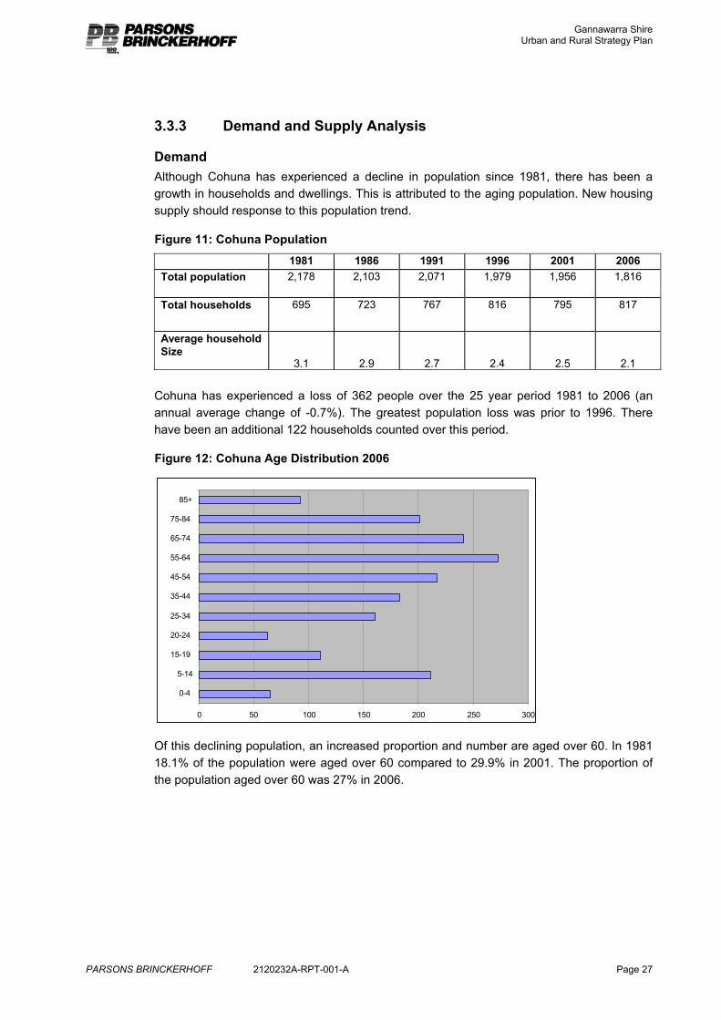
3.3.3 Demand and Supply Analysis
Demand Although Cohuna has experienced a decline in population since 1981, there has been a growth in households and dwellings. This is attributed to the aging population. New housing supply should response to this population trend.
Figure 11: Cohuna Population
1981 1986 1991 1996 2001 2006 Total population 2,178 2,103 2,071 1,979 1,956 1,816
Total households 695 723 767 816 795 817
Average household Size
3.1 2.9 2.7 2.4 2.5
2.1
Cohuna has experienced a loss of 362 people over the 25 year period 1981 to 2006 (an annual average change of -0.7%). The greatest population loss was prior to 1996. There have been an additional 122 households counted over this period.
Figure 12: Cohuna Age Distribution 2006
0 50 100 150 200 250 300
0-4
5-14
15-19
20-24
25-34
35-44
45-54
55-64
65-74
75-84
85+
Of this declining population, an increased proportion and number are aged over 60. In 1981 18.1% of the population were aged over 60 compared to 29.9% in 2001. The proportion of the population aged over 60 was 27% in 2006.
Gannawarra Shire Urban and Rural Strategy Plan
PARSONS BRINCKERHOFF 2120232A-RPT-001-A Page 28
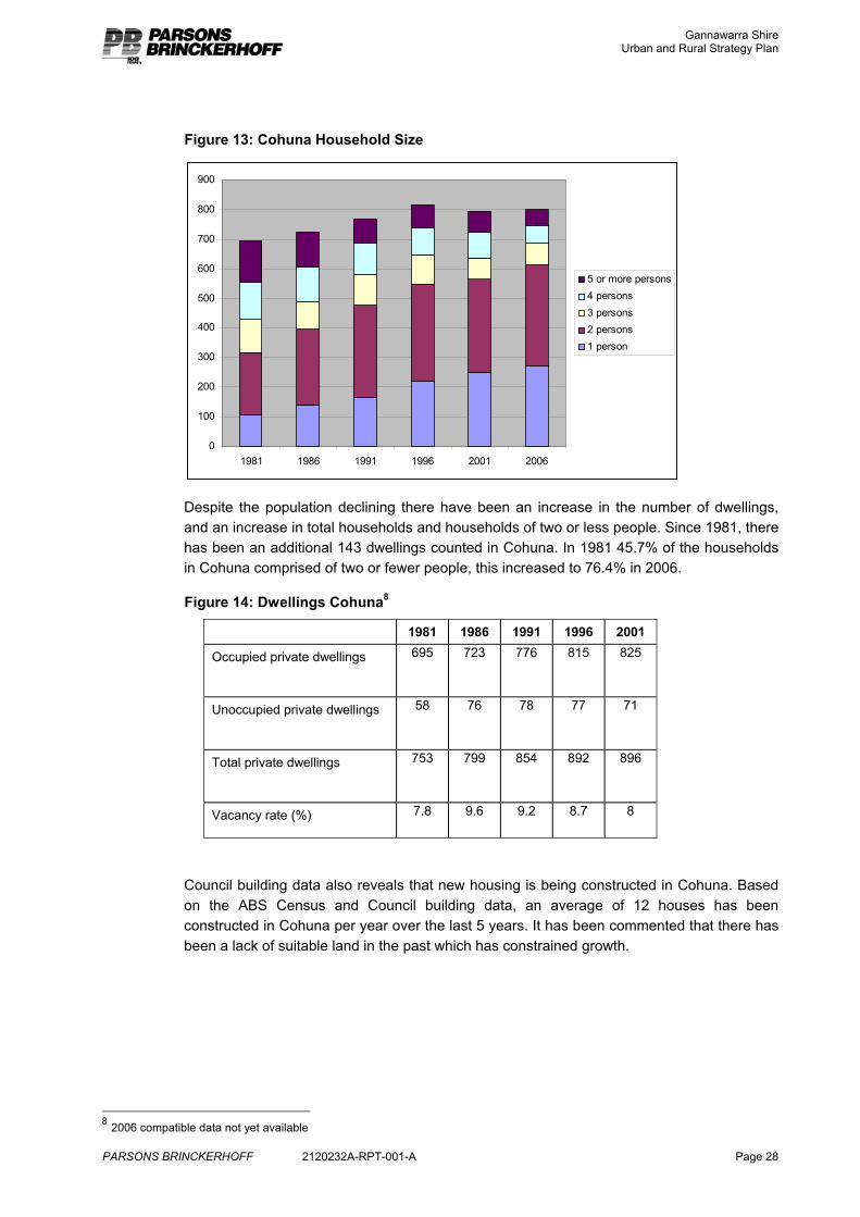
Figure 13: Cohuna Household Size
0
100
200
300
400
500
600
700
800
900
1981 1986 1991 1996 2001 2006
5 or more persons4 persons3 persons2 persons1 person
Despite the population declining there have been an increase in the number of dwellings, and an increase in total households and households of two or less people. Since 1981, there has been an additional 143 dwellings counted in Cohuna. In 1981 45.7% of the households in Cohuna comprised of two or fewer people, this increased to 76.4% in 2006.
Figure 14: Dwellings Cohuna8
1981 1986 1991 1996 2001
Occupied private dwellings 695 723 776 815 825
Unoccupied private dwellings 58 76 78 77 71
Total private dwellings 753 799 854 892 896
Vacancy rate (%) 7.8 9.6 9.2 8.7 8
Council building data also reveals that new housing is being constructed in Cohuna. Based on the ABS Census and Council building data, an average of 12 houses has been constructed in Cohuna per year over the last 5 years. It has been commented that there has been a lack of suitable land in the past which has constrained growth.
8 2006 compatible data not yet available
Gannawarra Shire Urban and Rural Strategy Plan
PARSONS BRINCKERHOFF 2120232A-RPT-001-A Page 29
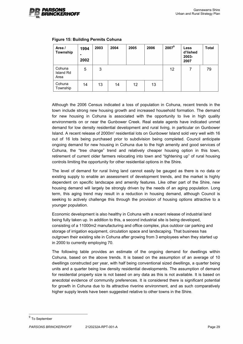
Figure 15: Building Permits Cohuna
Area / Township
1994-2002
2003 2004 2005 2006 20079 Less d’lished 2003-2007
Total
Cohuna Island Rd Area
5 3
Cohuna Township
14 13 14 12 13
12 7 79
Although the 2006 Census indicated a loss of population in Cohuna, recent trends in the town include strong new housing growth and increased household formation. The demand for new housing in Cohuna is associated with the opportunity to live in high quality environments on or near the Gunbower Creek. Real estate agents have indicated unmet demand for low density residential development and rural living, in particular on Gunbower Island. A recent release of 2000m2 residential lots on Gunbower Island sold very well with 16 out of 16 lots being purchased prior to subdivision being completed. Council anticipate ongoing demand for new housing in Cohuna due to the high amenity and good services of Cohuna, the “tree change” trend and relatively cheaper housing option in this town, retirement of current older farmers relocating into town and “tightening up” of rural housing controls limiting the opportunity for other residential options in the Shire.
The level of demand for rural living land cannot easily be gauged as there is no data or existing supply to enable an assessment of development trends, and the market is highly dependent on specific landscape and amenity features. Like other part of the Shire, new housing demand will largely be strongly driven by the needs of an aging population. Long term, this aging trend may result in a reduction in housing demand, although Council is seeking to actively challenge this through the provision of housing options attractive to a younger population.
Economic development is also healthy in Cohuna with a recent release of industrial land being fully taken up. In addition to this, a second industrial site is being developed, consisting of a 11000m2 manufacturing and office complex, plus outdoor car parking and storage of irrigation equipment, circulation space and landscaping. That business has outgrown their existing site in Cohuna after growing from 3 employees when they started up in 2000 to currently employing 70.
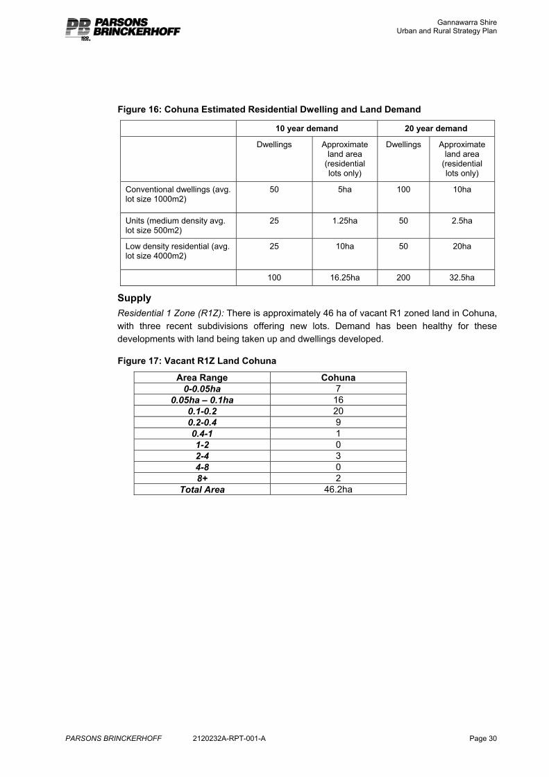
The following table provides an estimate of the ongoing demand for dwellings within Cohuna, based on the above trends. It is based on the assumption of an average of 10 dwellings constructed per year, with half being conventional sized dwellings, a quarter being units and a quarter being low density residential developments. The assumption of demand for residential property size is not based on any data as this is not available. It is based on anecdotal evidence of community preferences. It is considered there is significant potential for growth in Cohuna due to its attractive riverine environment, and as such comparatively higher supply levels have been suggested relative to other towns in the Shire.
9 To September
Gannawarra Shire Urban and Rural Strategy Plan
PARSONS BRINCKERHOFF 2120232A-RPT-001-A Page 30
Figure 16: Cohuna Estimated Residential Dwelling and Land Demand
10 year demand 20 year demand
Dwellings Approximate land area
(residential lots only)
Dwellings Approximate land area
(residential lots only)
Conventional dwellings (avg. lot size 1000m2)
50
5ha 100 10ha
Units (medium density avg. lot size 500m2)
25 1.25ha 50 2.5ha
Low density residential (avg. lot size 4000m2)
25
10ha 50 20ha
100 16.25ha 200 32.5ha
Supply Residential 1 Zone (R1Z): There is approximately 46 ha of vacant R1 zoned land in Cohuna, with three recent subdivisions offering new lots. Demand has been healthy for these developments with land being taken up and dwellings developed.
Figure 17: Vacant R1Z Land Cohuna
Area Range Cohuna 0-0.05ha 7
0.05ha – 0.1ha 16 0.1-0.2 20 0.2-0.4 9 0.4-1 1 1-2 0 2-4 3 4-8 0 8+ 2
Total Area 46.2ha
Gannawarra Shire Urban and Rural Strategy Plan
PARSONS BRINCKERHOFF 2120232A-RPT-001-A Page 31
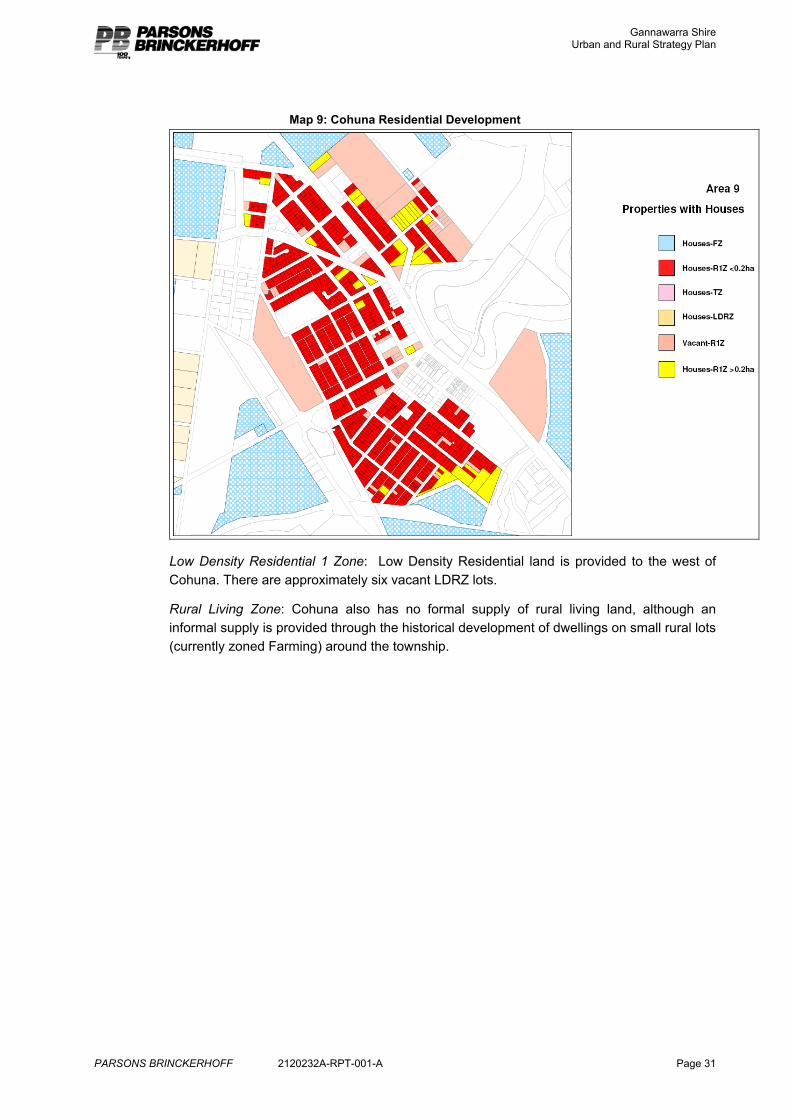
Map 9: Cohuna Residential Development
Low Density Residential 1 Zone: Low Density Residential land is provided to the west of Cohuna. There are approximately six vacant LDRZ lots.
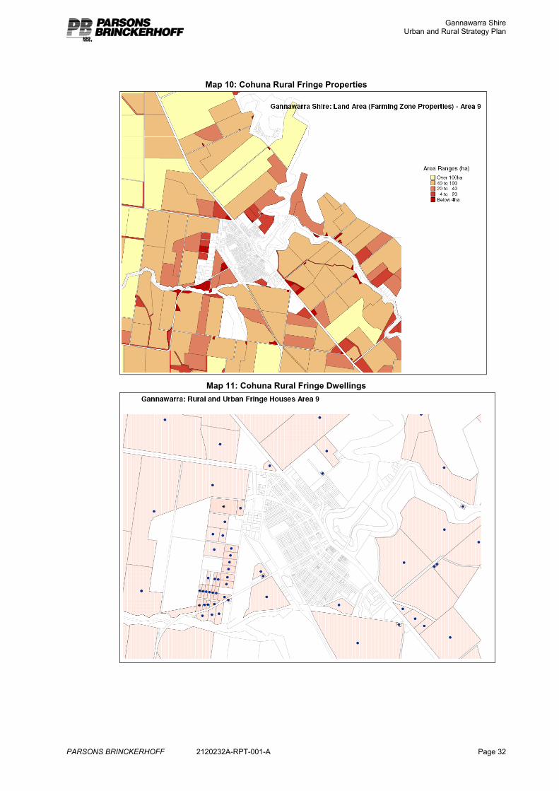
Rural Living Zone: Cohuna also has no formal supply of rural living land, although an informal supply is provided through the historical development of dwellings on small rural lots (currently zoned Farming) around the township.
Gannawarra Shire Urban and Rural Strategy Plan
PARSONS BRINCKERHOFF 2120232A-RPT-001-A Page 32
Map 10: Cohuna Rural Fringe Properties
Map 11: Cohuna Rural Fringe Dwellings
Gannawarra Shire Urban and Rural Strategy Plan
PARSONS BRINCKERHOFF 2120232A-RPT-001-A Page 33
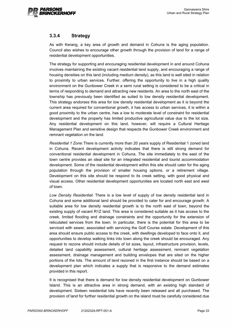
3.3.4 Strategy
As with Kerang, a key area of growth and demand in Cohuna is the aging population. Council also wishes to encourage other growth through the provision of land for a range of residential development opportunities.
The strategy for supporting and encouraging residential development in and around Cohuna involves maintaining the existing vacant residential land supply, and encouraging a range of housing densities on this land (including medium density), as this land is well sited in relation to proximity to urban services. Further, offering the opportunity to live in a high quality environment on the Gunbower Creek in a semi rural setting is considered to be a critical in terms of responding to demand and attracting new residents. An area to the north east of the township has previously been identified as suited to low density residential development. This strategy endorses this area for low density residential development as it is beyond the current area required for conventional growth, it has access to urban services, it is within a good proximity to the urban centre, has a low to moderate level of constraint for residential development and the property has limited productive agricultural value due to the lot size. Any residential development on this land, however, will require a Cultural Heritage Management Plan and sensitive design that respects the Gunbower Creek environment and remnant vegetation on the land.
Residential 1 Zone: There is currently more than 20 years supply of Residential 1 zoned land in Cohuna. Recent development activity indicates that there is still strong demand for conventional residential development in Cohuna. The site immediately to the east of the town centre provides an ideal site for an integrated residential and tourist accommodation development. Some of the residential development within this site should cater for the aging population through the provision of smaller housing options, or a retirement village. Development on this site should be respond to its creek setting, with good physical and visual access. Other residential development opportunities are located north east and west of town.
Low Density Residential: There is a low level of supply of low density residential land in Cohuna and some additional land should be provided to cater for and encourage growth. A suitable area for low density residential growth is to the north east of town, beyond the existing supply of vacant R1Z land. This area is considered suitable as it has access to the creek, limited flooding and drainage constraints and the opportunity for the extension of reticulated services from the town. In particular, there is the potential for this area to be serviced with sewer, associated with servicing the Golf Course estate. Development of this area should ensure public access to the creek, with dwellings developed to face onto it, and opportunities to develop walking links into town along the creek should be encouraged. Any request to rezone should include details of lot sizes, layout, infrastructure provision, levels, detailed land capability assessment, cultural heritage assessment, remnant vegetation assessment, drainage management and building envelopes that are sited on the higher portions of the lots. The amount of land rezoned in the first instance should be based on a development plan which indicates a supply that is responsive to the demand estimates provided in this report.
It is recognised that there is demand for low density residential development on Gunbower Island. This is an attractive area in strong demand, with an existing high standard of development. Sixteen residential lots have recently been released and all purchased. The provision of land for further residential growth on the island must be carefully considered due
Gannawarra Shire Urban and Rural Strategy Plan
PARSONS BRINCKERHOFF 2120232A-RPT-001-A Page 34
to flood risk, environmental values of the adjoining forest, expense of extending urban services to the area and agricultural values of the farming land.
In the short to medium term additional low density residential land is unlikely to be required (subject to the development of more suitable land to the north east of the township). In the longer term provision of additional land for low density residential on Gunbower Island could be considered. This needs to be focussed in the area to the west of Wilson’s Road initially to enable it to be connected to urban services and provide for a logical extension of the urban area. It also needs to be designed to respond to flood issues and environmental values. Land to the east of Wilson’s Road is still considered productive agricultural land due to lot size and soil quality and should not be subject to land use change at this time.
Rural Living Zone: The provision of some land for rural living around Cohuna could be appropriate into the future as the environmental constraints in this area are lower than in other parts of the Shire. In determining the location of the supply and the level of supply Council needs to be mindful of the potential impact on productive farming units and the future prospects for such land. The ability to service proposed rural living areas, and the efficiency of the land use also needs to be considered. A number of Farming zoned properties around Cohuna are presently used for rural living purposes and future consideration could be given to the appropriateness of some further subdivision of these. As discussed elsewhere in the report an appropriate level of supply cannot be determined through this review as there is no demand data available. It is not recommended that any land be rezoned for rural living purposes at this time as there was not significant interest or demand expressed for this land use during the development of this strategy. It was generally concluded that most demand in this area was for residential and low density residential development. Some rural living properties (up to 2ha) could be incorporated into the low density residential development to the north east of the town to achieve the desired rural amenity sought.
Industrial: Separate to this project, Council is assessing the merits of a site to the north of town for a significant new industrial development. This site is required to enable growth of an existing business, as other industrial land options in Cohuna are unsuitable. This site is considered suitable as it has access to the necessary services and is isolated from the residential growth areas.
Gannawarra Shire Urban and Rural Strategy Plan
PARSONS BRINCKERHOFF 2120232A-RPT-001-A Page 35
Map 12: Cohuna Residential Growth Plan
Gannawarra Shire Urban and Rural Strategy Plan
PARSONS BRINCKERHOFF 2120232A-RPT-001-A Page 36
3.4 Murrabit Murrabit performs an important service role to the surrounding rural community, and events such as the Murrabit community market are important to the future role of Murrabit10. Murrabit has a unique small town character related to its proximity to the Murray River.
It is estimated that Murrabit has a population of approximately 100, although having an aging and declining population, it is slowly becoming home to workers in nearby Swan Hill, Barham and Kerang.11
3.4.1 Existing Strategy
The current strategy for residential development in Murrabit is to encourage any growth in and around the town. Council is presently working with Lower Murray Water to provide reticulated sewer in the town, which will enhance growth opportunities.
3.4.2 Land Audit
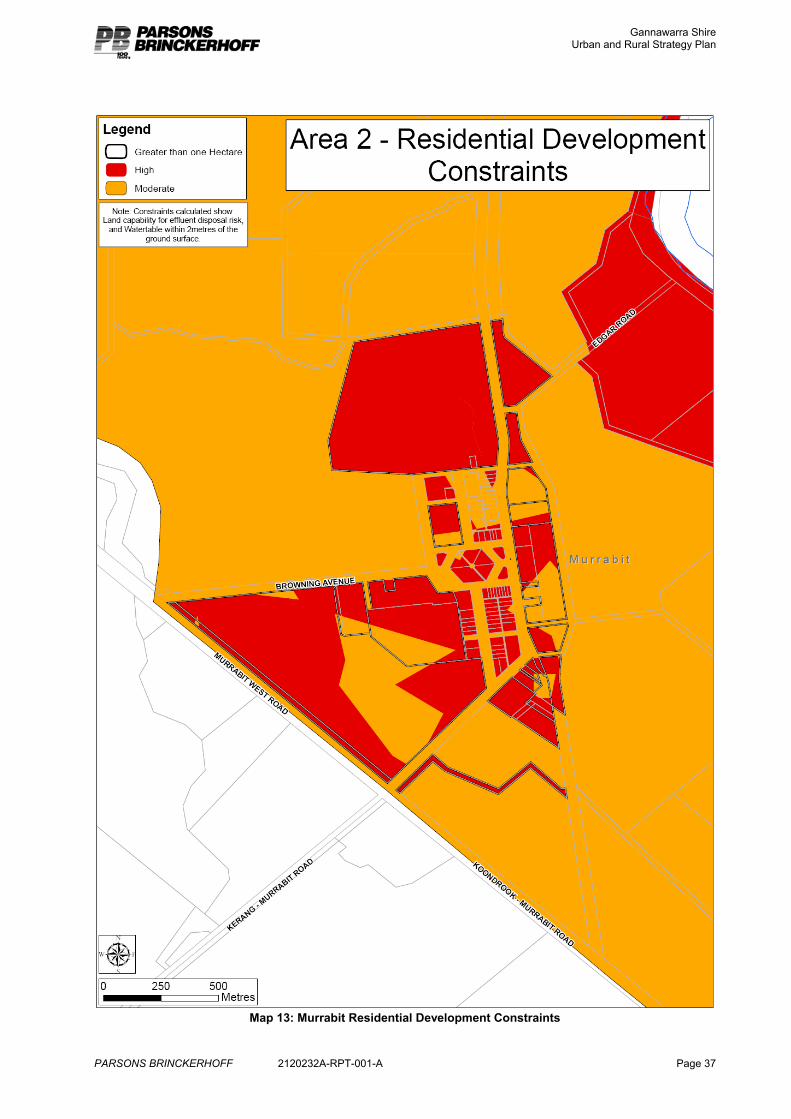
Constraints and opportunities for residential and rural residential growth around Murrabit include the Murray River and related issues of flooding and poor drainage which extend across the township and surrounds, and the unsuitable size of existing lots for effluent disposal. The town has some protection from flooding by an existing levee bank along the frontage of the Murray River (this levee was not overtopped in the floods of the 1970s, 1980s and 1990s) and the GMW channel to the east of the town. The North Central Catchment Management Authority (the floodplain management authority) has advised that any further residential development in the area between the GMW channel and the Murray River should be avoided due to risk to residents and property from significant flood levels, and associated issues of compliance with building and domestic waste water management requirements.
This flooding risk has been determined by the North Central Catchment Management Authority from extensive modelling and historical data. The CMA have advised that development within the township should be limited to land at or above 73.2 AHD, as on land below this height the flood depth will exceed 500mm in a 1 in 100 year event.
Other constraints to the development of land within the town will be significantly reduced through the introduction of sewer.
Agricultural change, largely associated with the drought and sale of irrigation water, has impacted on the productivity of agricultural properties within the area. A number of properties around the town have limited productive value without water.
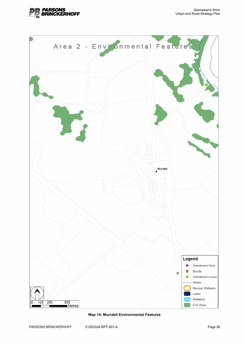
Land within 200m of the Murray River and some land immediately to the north of the township are Areas of Cultural Heritage Sensitivity.
There are a number of sites of remnant vegetation around the town.
Notes on the approach to the residential constraints analysis are included in Appendix A.
10 Gannawarra MSS Clause 21.04 11 Pride of Place Program, Small Towns Development Plans, Lalbet, Leitchville, Murrabit and Quambatook, 2005.
Gannawarra Shire Urban and Rural Strategy Plan
PARSONS BRINCKERHOFF 2120232A-RPT-001-A Page 37
Map 13: Murrabit Residential Development Constraints
Gannawarra Shire Urban and Rural Strategy Plan
PARSONS BRINCKERHOFF 2120232A-RPT-001-A Page 38
Map 14: Murrabit Environmental Features
Gannawarra Shire Urban and Rural Strategy Plan
PARSONS BRINCKERHOFF 2120232A-RPT-001-A Page 39
3.4.3 Demand and Supply Analysis
Demand No ABS Census data is available specifically for Murrabit due to its small size. Council estimates indicate that the population of Murrabit is in the vicinity of 100 people. A number of new dwellings have been constructed around the town in recent years.
Anecdotal evidence indicates demand for residential and rural residential properties in the area.
Figure 18: Building Permits Murrabit
Area / Township
1994-2002 2002-2007 Less Demolished 2003-2007
Total
Murrabit / Benjeroop
8 9 1 16
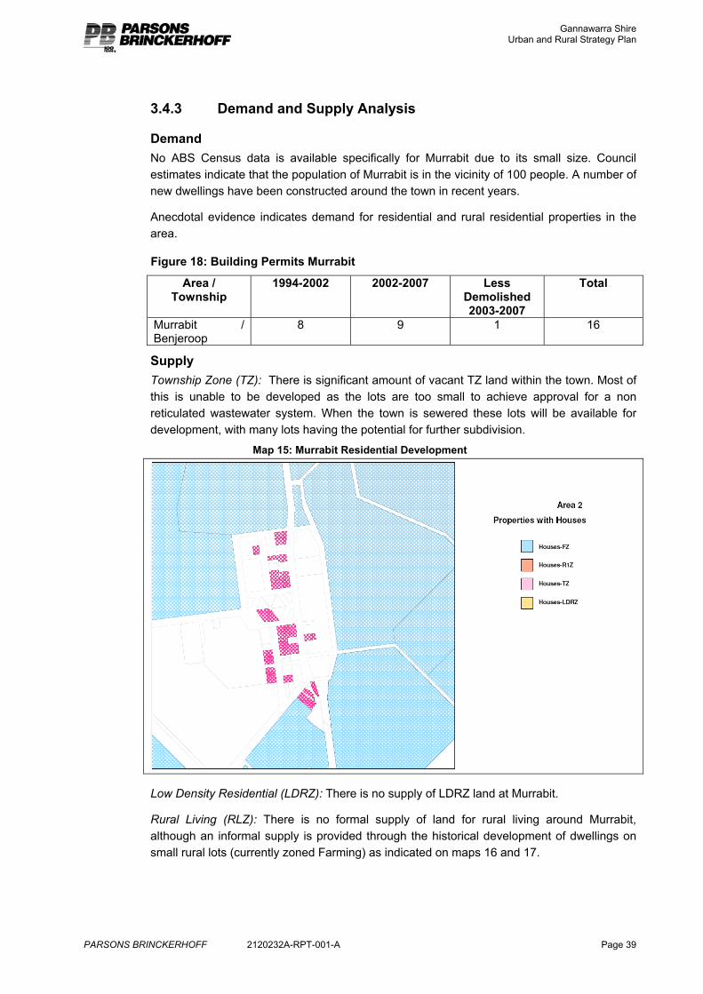
Supply Township Zone (TZ): There is significant amount of vacant TZ land within the town. Most of this is unable to be developed as the lots are too small to achieve approval for a non reticulated wastewater system. When the town is sewered these lots will be available for development, with many lots having the potential for further subdivision.
Map 15: Murrabit Residential Development
Low Density Residential (LDRZ): There is no supply of LDRZ land at Murrabit.
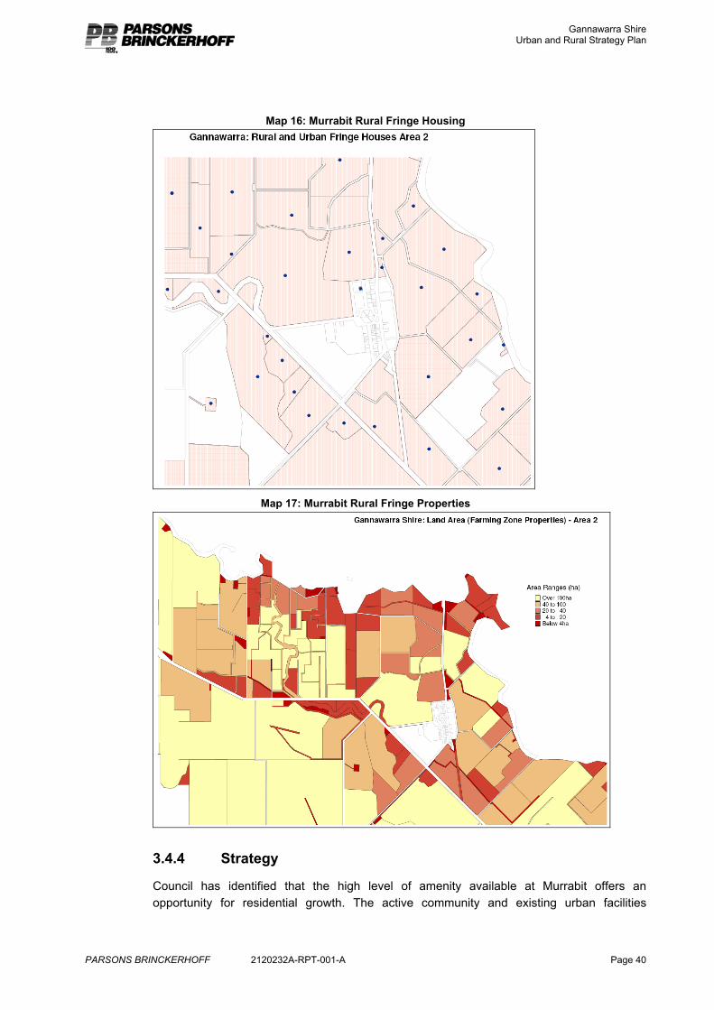
Rural Living (RLZ): There is no formal supply of land for rural living around Murrabit, although an informal supply is provided through the historical development of dwellings on small rural lots (currently zoned Farming) as indicated on maps 16 and 17.
Gannawarra Shire Urban and Rural Strategy Plan
PARSONS BRINCKERHOFF 2120232A-RPT-001-A Page 40
Map 16: Murrabit Rural Fringe Housing
Map 17: Murrabit Rural Fringe Properties
3.4.4 Strategy
Council has identified that the high level of amenity available at Murrabit offers an opportunity for residential growth. The active community and existing urban facilities
Gannawarra Shire Urban and Rural Strategy Plan
PARSONS BRINCKERHOFF 2120232A-RPT-001-A Page 41
provides a good basis for new residential development. Anecdotal evidence indicates demand for residential development within the area, particularly close to the river.
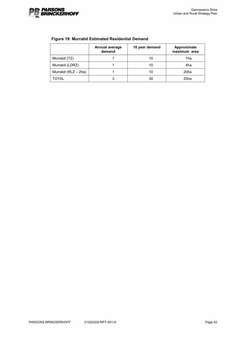
The strategy for the future of Murrabit includes supporting infill and expansion of the town facilitated through the introduction of sewer. New residential development opportunities should also be captured through the provision of attractive semi rural development around the town. Although there is strong demand for development on the Murray River, the North Central CMA has advised that the flood risk is high to the east of the GMW Channel and residential development in this area is unlikely to be supported. Instead, low density and rural living development should be focussed on suitable sites around the town, and walking and other links to the river be established to ensure that the river character and access is incorporated into the town surrounds.
A number of sites close to the town with merit for low density residential development have been identified. These sites have lower flood risk, are not required for conventional growth, have existing road access and are of lower agricultural productive value due to township proximity, remnant vegetation and lot size. Although some of these areas are identified on the constraints map as high, their suitability could be managed through appropriate design and servicing. The North Central CMA supports the strategy of focussing development around the township. One of these sites (to the north of town) would require a Cultural Heritage Management Plan as a part of any approvals process as it includes an Area of Cultural Heritage Sensitivity. Beyond these potential low density residential properties is an area of land which has merit for rural living. This area also has lower flood risk, is not required for conventional growth, has sealed road access, is able to be readily linked to the river (which is important in terms of attracting new residents) and, although it has agricultural productive potential, this is currently limited due to the sale of water. It is also considered that the potential value of the land in attracting new residents outweighs its agricultural value to the district. It is considered an important strategy to offer rural living land in this area to reduce demand in more isolated and sensitive areas along the river. The appropriate average lot size for this rural living area is 2ha. This is the size that is considered to offer opportunities for a range of semi rural activities, without imposing significant management requirements.
The amount of land required to reasonably respond to demand is difficult to calculate as there is limited historical demand data, and demand in the past has been limited by lack of supply. Council anticipate ongoing demand for new housing in Murrabit due to the high amenity of Murrabit, the availability of developable land, the “tree change” trend and relatively cheaper housing option in this town, retirement of current older farmers relocating into town and “tightening up” of rural housing controls limiting the opportunity for other residential options in the Shire.
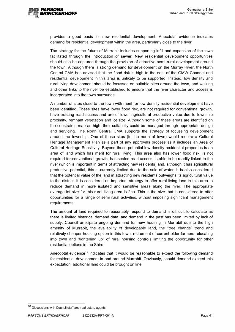
Anecdotal evidence12 indicates that it would be reasonable to expect the following demand for residential development in and around Murrabit. Obviously, should demand exceed this expectation, additional land could be brought on line.
12 Discussions with Council staff and real estate agents.
Gannawarra Shire Urban and Rural Strategy Plan
PARSONS BRINCKERHOFF 2120232A-RPT-001-A Page 42
Figure 19: Murrabit Estimated Residential Demand
Annual average demand
10 year demand Approximate maximum area
Murrabit (TZ) 1 10 1ha
Murrabit (LDRZ) 1 10 4ha
Murrabit (RLZ – 2ha) 1 10 20ha
TOTAL 3 30 25ha
Gannawarra Shire Urban and Rural Strategy Plan
PARSONS BRINCKERHOFF 2120232A-RPT-001-A Page 43
Map 18: Murrabit Residential Growth Plan
Gannawarra Shire Urban and Rural Strategy Plan
PARSONS BRINCKERHOFF 2120232A-RPT-001-A Page 44
3.5 Koondrook Koondrook is located on the Murray River and has a key relationship with Barham directly across the river in NSW. It performs the complimentary roles of a heritage, tourist, retiree and rural retreat town. The protection and enhancement of the blend of the built and natural environments and river town character are important to the role of the town13. At the 2006 Census its population was 759 and was the only urban area in the Shire to have experienced population growth. Koondrook increased in population by 1.3% between 1996 and 2006. Much of the town is zoned Residential 1 to provide for residential development. There is land zoned Low Density Residential to the south, west and north of Koondrook.
3.5.1 Existing Strategy
The current strategy for residential development in Koondrook is;
� future residential development is to be encouraged at locations within the existing urban area by developing existing vacant lots and consolidation the urban area
� areas for new residential development must be capable of being serviced with underground drainage, where available, and all new residential development must be able to connect to the existing sewerage system
� future low-density residential development is to be strongly encouraged within the urban area boundary at locations to the north and south of the urban area identified on the Koondrook Structure Plan
� future development of the urban area that supports and strengthens Koondrook’s role as a retirement centre will be encouraged. Locations for retirement and elderly persons housing that are adjacent to the town centre will be strongly encouraged
� well-designed medium density housing development is to be encouraged.
13 Gannawarra MSS – Clause 21.04
Gannawarra Shire Urban and Rural Strategy Plan
PARSONS BRINCKERHOFF 2120232A-RPT-001-A Page 45
3.5.2 Land Audit
Koondrook township has a high level of constraint for residential development, largely associated with the flooding risk. This flooding risk has been determined by the North Central Catchment Management Authority from extensive modelling and historical data.
Some of this risk can be managed through land filling, connection to sewer and elevated floor levels. Drainage works and levees also provides for some mitigation of the flood issue.
There is a lower risk of flooding in the southern part of the town and to the west of the town.
Land along the Murray River is an Area of Cultural Heritage Sensitivity.
Although most farm land beyond the town is suitable for irrigation due to soil type, adjacent to town land is in smaller lots which compromises its productive potential
Environmental values around Koondrook include remnant vegetation, Ramsar wetland area and threatened fauna sites.
Notes on the approach to the residential constraints analysis are included in Appendix A.
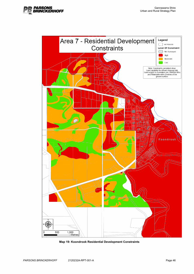
Gannawarra Shire Urban and Rural Strategy Plan
PARSONS BRINCKERHOFF 2120232A-RPT-001-A Page 46
Map 19: Koondrook Residential Development Constraints
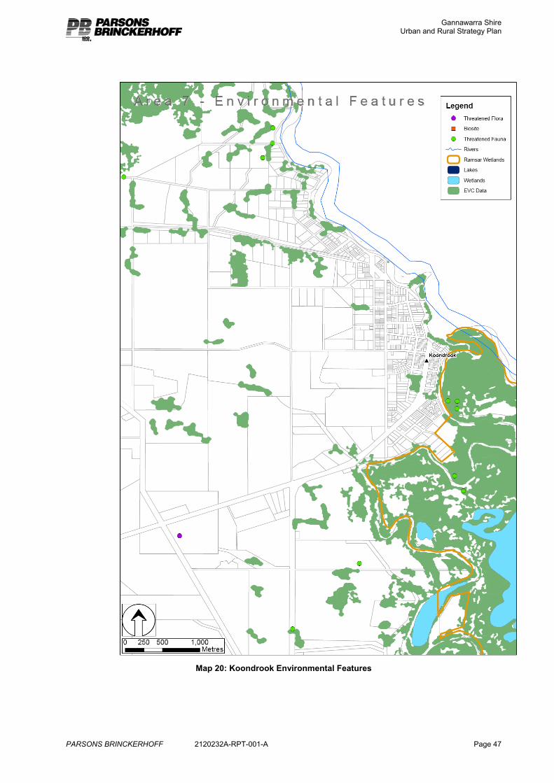
Gannawarra Shire Urban and Rural Strategy Plan
PARSONS BRINCKERHOFF 2120232A-RPT-001-A Page 47
Map 20: Koondrook Environmental Features
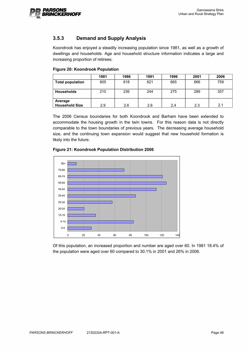
Gannawarra Shire Urban and Rural Strategy Plan
PARSONS BRINCKERHOFF 2120232A-RPT-001-A Page 48
3.5.3 Demand and Supply Analysis
Koondrook has enjoyed a steadily increasing population since 1981, as well as a growth of dwellings and households. Age and household structure information indicates a large and increasing proportion of retirees.
Figure 20: Koondrook Population 1981 1986 1991 1996 2001 2006
Total population 605 618 621 665 666 759
Households 210 236 244 275 289 357
Average Household Size 2.9 2.6 2.6 2.4 2.3
2.1
The 2006 Census boundaries for both Koondrook and Barham have been extended to accommodate the housing growth in the twin towns. For this reason data is not directly comparable to the town boundaries of previous years. The decreasing average household size, and the continuing town expansion would suggest that new household formation is likely into the future.
Figure 21: Koondrook Population Distribution 2006
0 20 40 60 80 100 120 140
0-4
5-14
15-19
20-24
25-34
35-44
45-54
55-64
65-74
75-84
85+
Of this population, an increased proportion and number are aged over 60. In 1981 18.4% of the population were aged over 60 compared to 30.1% in 2001 and 26% in 2006.
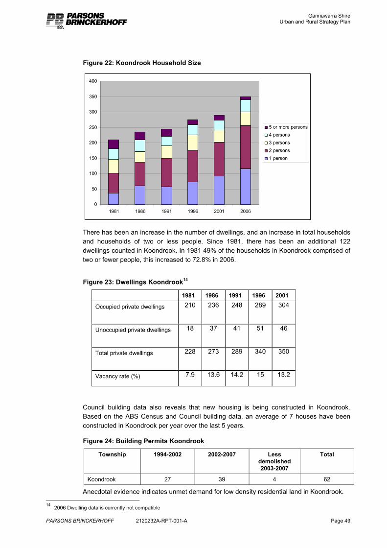
Gannawarra Shire Urban and Rural Strategy Plan
PARSONS BRINCKERHOFF 2120232A-RPT-001-A Page 49
Figure 22: Koondrook Household Size
0
50
100
150
200
250
300
350
400
1981 1986 1991 1996 2001 2006
5 or more persons4 persons3 persons2 persons1 person
There has been an increase in the number of dwellings, and an increase in total households and households of two or less people. Since 1981, there has been an additional 122 dwellings counted in Koondrook. In 1981 49% of the households in Koondrook comprised of two or fewer people, this increased to 72.8% in 2006.
Figure 23: Dwellings Koondrook14
1981 1986 1991 1996 2001
Occupied private dwellings 210 236 248 289 304
Unoccupied private dwellings 18 37 41 51 46
Total private dwellings 228 273 289 340 350
Vacancy rate (%) 7.9 13.6 14.2 15 13.2
Council building data also reveals that new housing is being constructed in Koondrook. Based on the ABS Census and Council building data, an average of 7 houses have been constructed in Koondrook per year over the last 5 years.
Figure 24: Building Permits Koondrook
Township 1994-2002 2002-2007 Less demolished 2003-2007
Total
Koondrook 27 39 4 62
Anecdotal evidence indicates unmet demand for low density residential land in Koondrook. 14 2006 Dwelling data is currently not compatible
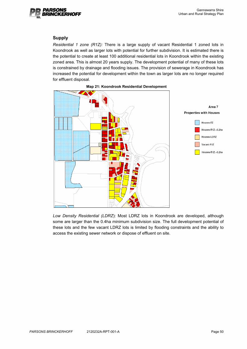
Gannawarra Shire Urban and Rural Strategy Plan
PARSONS BRINCKERHOFF 2120232A-RPT-001-A Page 50
Supply Residential 1 zone (R1Z): There is a large supply of vacant Residential 1 zoned lots in Koondrook as well as larger lots with potential for further subdivision. It is estimated there is the potential to create at least 100 additional residential lots in Koondrook within the existing zoned area. This is almost 20 years supply. The development potential of many of these lots is constrained by drainage and flooding issues. The provision of sewerage in Koondrook has increased the potential for development within the town as larger lots are no longer required for effluent disposal.
Map 21: Koondrook Residential Development
Low Density Residential (LDRZ): Most LDRZ lots in Koondrook are developed, although some are larger than the 0.4ha minimum subdivision size. The full development potential of these lots and the few vacant LDRZ lots is limited by flooding constraints and the ability to access the existing sewer network or dispose of effluent on site.
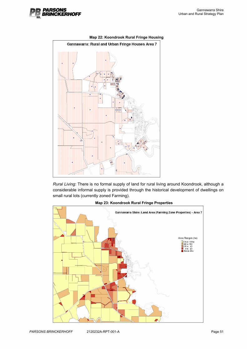
Gannawarra Shire Urban and Rural Strategy Plan
PARSONS BRINCKERHOFF 2120232A-RPT-001-A Page 51
Map 22: Koondrook Rural Fringe Housing
Rural Living: There is no formal supply of land for rural living around Koondrook, although a considerable informal supply is provided through the historical development of dwellings on small rural lots (currently zoned Farming).
Map 23: Koondrook Rural Fringe Properties
Gannawarra Shire Urban and Rural Strategy Plan
PARSONS BRINCKERHOFF 2120232A-RPT-001-A Page 52
3.5.4 Strategy
Koondrook has considerable potential for residential growth due to its attractive setting, existing services and links with Barham across the river. Although the existing urban area is constrained due to flood risk, it still offers opportunity for additional residential development, through elevated floor levels, connection to sewer, filling, density management and storm water drainage. There is a small part of the low density area to the south of the township that is on higher ground and has access to sewer and therefore could support higher density development. The North Central CMA supports development within the existing town, subject to appropriate design.
Opportunities for further residential and low density residential development should be provided to the west of the town where there is no flood risk, there is access to sewer and it is still close to the centre of town. Land to the west of the town is also suited to rural living as it is largely flood free and most of the properties in this area are already of a size that indicates they are no longer used productively for farming. The appropriate average lot size for this rural living area is 2ha. This is the size that is considered to offer opportunities for a range of semi rural activities, without imposing significant management requirements.
The amount of land required to reasonably respond to demand is difficult to calculate as there is limited historical demand data. Anecdotal evidence15 and Council building data indicates that it would be reasonable to expect the following demand for residential development in and around Koondrook.
Figure 25: Koondrook Estimated Residential Demand
Annual average demand
10 year demand Approximate maximum area
Koondrook (R1Z) 3 30 6ha
Koondrook (LDRZ) 3 30 12ha
Koondrook (RLZ – 2ha) 2 20 40ha
TOTAL 8 80
15 Discussions with Council staff and real estate agents.
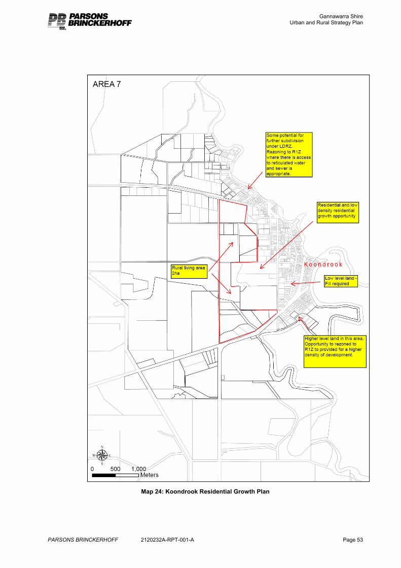
Gannawarra Shire Urban and Rural Strategy Plan
PARSONS BRINCKERHOFF 2120232A-RPT-001-A Page 53
Map 24: Koondrook Residential Growth Plan
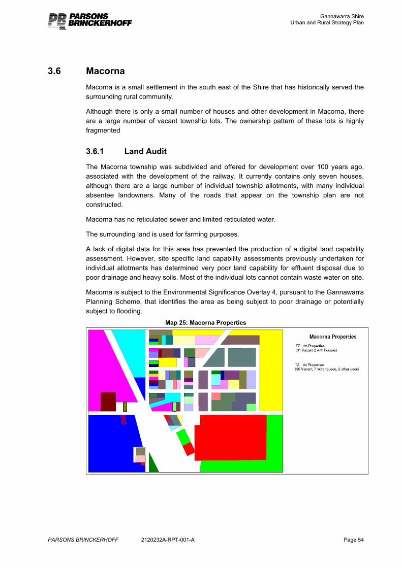
Gannawarra Shire Urban and Rural Strategy Plan
PARSONS BRINCKERHOFF 2120232A-RPT-001-A Page 54
3.6 Macorna Macorna is a small settlement in the south east of the Shire that has historically served the surrounding rural community.
Although there is only a small number of houses and other development in Macorna, there are a large number of vacant township lots. The ownership pattern of these lots is highly fragmented
3.6.1 Land Audit
The Macorna township was subdivided and offered for development over 100 years ago, associated with the development of the railway. It currently contains only seven houses, although there are a large number of individual township allotments, with many individual absentee landowners. Many of the roads that appear on the township plan are not constructed.
Macorna has no reticulated sewer and limited reticulated water.
The surrounding land is used for farming purposes.
A lack of digital data for this area has prevented the production of a digital land capability assessment. However, site specific land capability assessments previously undertaken for individual allotments has determined very poor land capability for effluent disposal due to poor drainage and heavy soils. Most of the individual lots cannot contain waste water on site.
Macorna is subject to the Environmental Significance Overlay 4, pursuant to the Gannawarra Planning Scheme, that identifies the area as being subject to poor drainage or potentially subject to flooding.
Map 25: Macorna Properties
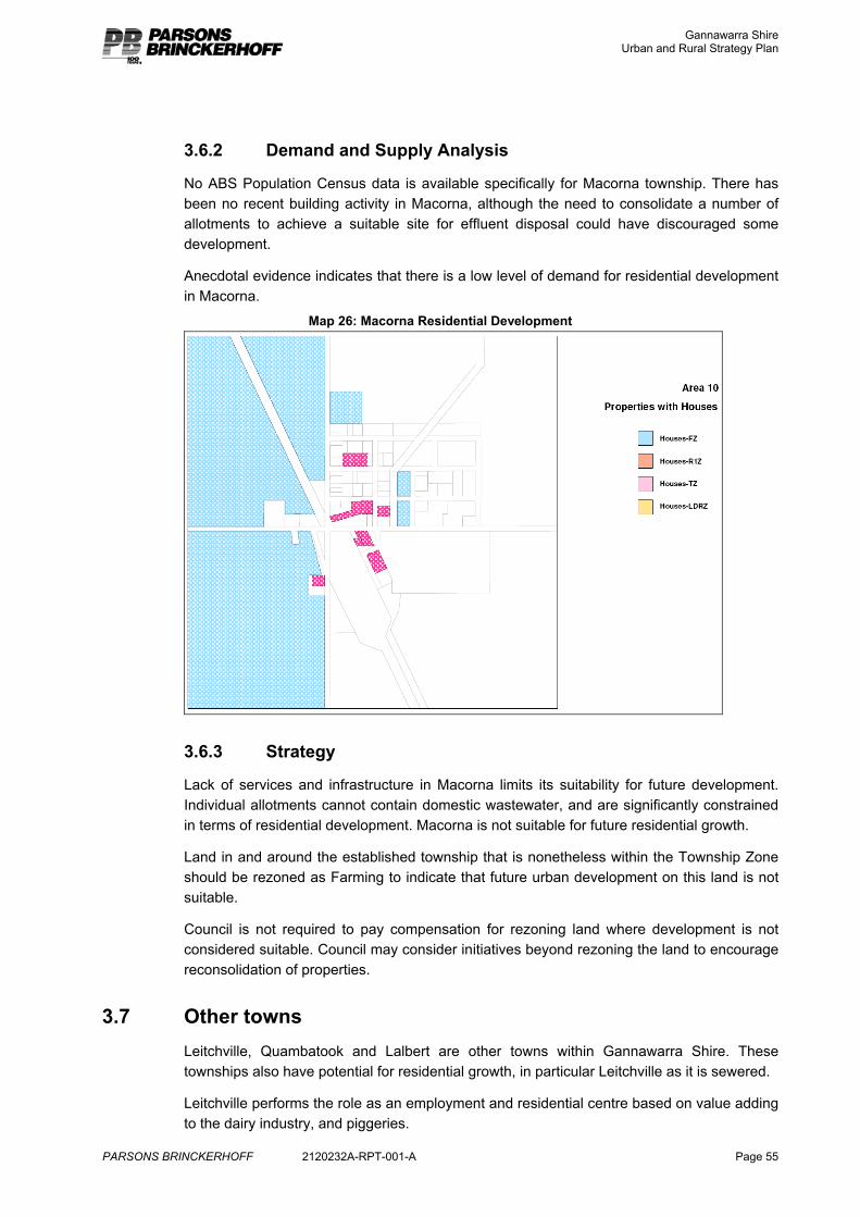
Gannawarra Shire Urban and Rural Strategy Plan
PARSONS BRINCKERHOFF 2120232A-RPT-001-A Page 55
3.6.2 Demand and Supply Analysis
No ABS Population Census data is available specifically for Macorna township. There has been no recent building activity in Macorna, although the need to consolidate a number of allotments to achieve a suitable site for effluent disposal could have discouraged some development.
Anecdotal evidence indicates that there is a low level of demand for residential development in Macorna.
Map 26: Macorna Residential Development
3.6.3 Strategy
Lack of services and infrastructure in Macorna limits its suitability for future development. Individual allotments cannot contain domestic wastewater, and are significantly constrained in terms of residential development. Macorna is not suitable for future residential growth.
Land in and around the established township that is nonetheless within the Township Zone should be rezoned as Farming to indicate that future urban development on this land is not suitable.
Council is not required to pay compensation for rezoning land where development is not considered suitable. Council may consider initiatives beyond rezoning the land to encourage reconsolidation of properties.
3.7 Other towns Leitchville, Quambatook and Lalbert are other towns within Gannawarra Shire. These townships also have potential for residential growth, in particular Leitchville as it is sewered.
Leitchville performs the role as an employment and residential centre based on value adding to the dairy industry, and piggeries.
Gannawarra Shire Urban and Rural Strategy Plan
PARSONS BRINCKERHOFF 2120232A-RPT-001-A Page 56
Quambatook performs the role of a local community centre for the surrounding farming community. The town and community are dependent on other centres for most services. The community has developed a high degree of self-reliance against a background of declining level of services.
The strategies from the Gannawarra MSS for Leitchville include:
� Future residential development (10 to 15 years) is to be strongly encouraged at locations north of the Cohuna/Leitchville Road and to the south of the town.
� New retail and business development is encouraged to cluster with existing town centre facilities.
The strategies from the Gannawarra MSS for Quambatook include:
� Development that complements and enhances Quambatook’s rural character and townscape will be strongly encouraged.
� A flexible approach to land use and development planning in Quambatook will be supported to facilitate new development opportunities.
� Development proposals that support Quambatook’s local community centre role by providing opportunities to maintain existing services or provide new services will be strongly encouraged.
� Support retention of sports and community facilities.
Gannawarra Shire Urban and Rural Strategy Plan
PARSONS BRINCKERHOFF 2120232A-RPT-001-A Page 57
4. Special Investigation Areas Council’s brief for the project advises that the Special Investigation Areas are based on the significant amount of developer enquiry for the areas (particularly tourist activities), the relatively low levels of current development, their access to and appreciation of water and low levels of environmental constraints. Council has advised that they view these areas as opportunities to attract new residents to the municipality and arrest the loss of young people and general population decline. This component of the project involves a review of the attributes of these areas and the identification of any opportunities for land use change.
The special investigation areas are:
1. Kangaroo Lake/Lake Charm
2. Along the Gunbower Creek north and south east of Cohuna
3. Along the Murray River between Myall and Benjeroop
4. Land to the east of the Reedy Lakes system
4.1 Kangaroo Lake/Lake Charm Kangaroo Lake and Lake Charm are located approximately 17km north west of Kerang. These two lakes are significant tourist and recreation facilities within the Shire, and attract people for water sports and camping. There are a number of caravan parks, holiday homes and permanent residences located around the fringe of the lakes. Beyond the immediate lake environs are broad acre farming areas and a significant development of viticulture to the west of Kangaroo Lake.
There are basic services supporting this area including a public hall, licensed supermarket, post office, State school and fuel outlet.
Although this area offers an attractive residential and tourist location, wastewater management is currently substandard and the future role and operation of this water body is subject to review and may change in terms of the level of the water. The relative isolation of this area from the main settlements of the Shire, and the cost of service provision, along with any potential impact on valuable agricultural operations must be considered when making choices about the future function of this area.
4.1.1 Land Audit
The attractive qualities of the lake environs have historically encouraged residential development. Most lots immediately around the lake are used and developed for residential and rural residential purposes, as indicated by Maps 27 and 28, which provide an analysis of property size and dwelling location. There are also a few tourist developments (caravan parks) around the lakes.
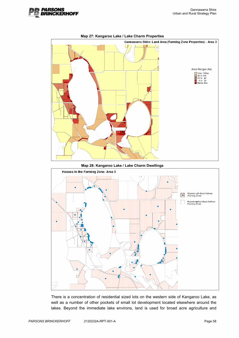
Gannawarra Shire Urban and Rural Strategy Plan
PARSONS BRINCKERHOFF 2120232A-RPT-001-A Page 58
Map 27: Kangaroo Lake / Lake Charm Properties
Map 28: Kangaroo Lake / Lake Charm Dwellings
There is a concentration of residential sized lots on the western side of Kangaroo Lake, as well as a number of other pockets of small lot development located elsewhere around the lakes. Beyond the immediate lake environs, land is used for broad acre agriculture and
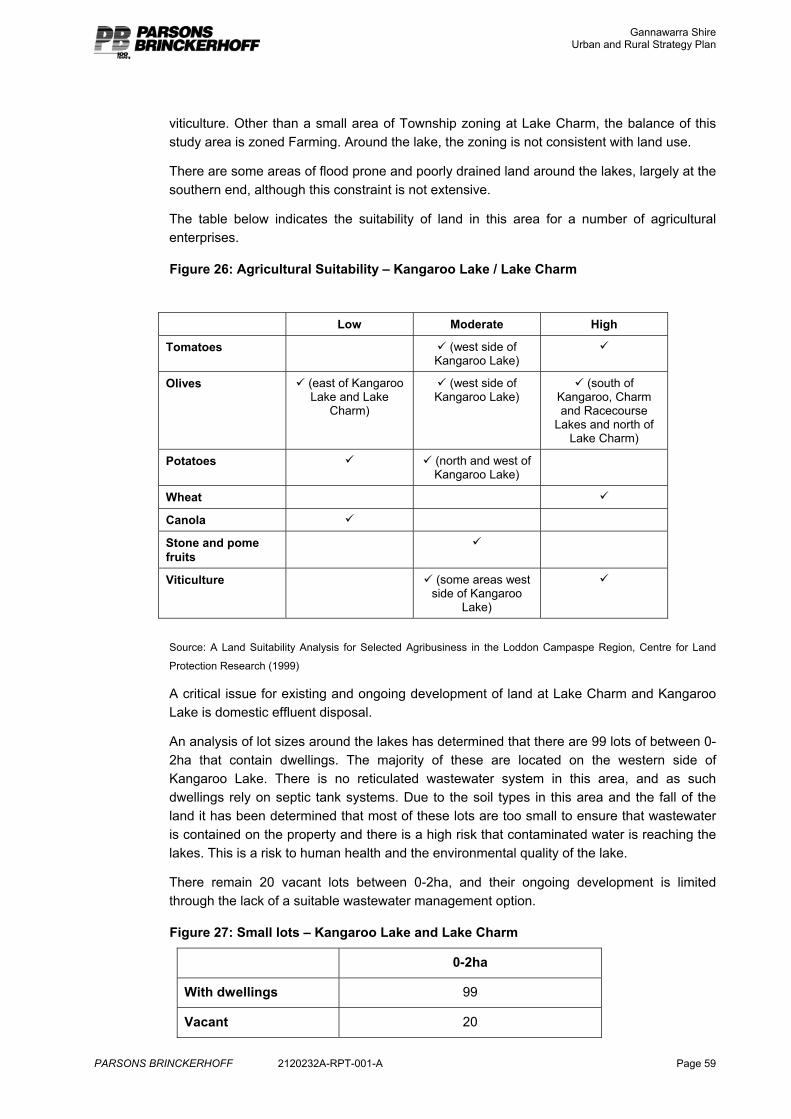
Gannawarra Shire Urban and Rural Strategy Plan
PARSONS BRINCKERHOFF 2120232A-RPT-001-A Page 59
viticulture. Other than a small area of Township zoning at Lake Charm, the balance of this study area is zoned Farming. Around the lake, the zoning is not consistent with land use.
There are some areas of flood prone and poorly drained land around the lakes, largely at the southern end, although this constraint is not extensive.
The table below indicates the suitability of land in this area for a number of agricultural enterprises.
Figure 26: Agricultural Suitability – Kangaroo Lake / Lake Charm
Source: A Land Suitability Analysis for Selected Agribusiness in the Loddon Campaspe Region, Centre for Land
Protection Research (1999)
A critical issue for existing and ongoing development of land at Lake Charm and Kangaroo Lake is domestic effluent disposal.
An analysis of lot sizes around the lakes has determined that there are 99 lots of between 0-2ha that contain dwellings. The majority of these are located on the western side of Kangaroo Lake. There is no reticulated wastewater system in this area, and as such dwellings rely on septic tank systems. Due to the soil types in this area and the fall of the land it has been determined that most of these lots are too small to ensure that wastewater is contained on the property and there is a high risk that contaminated water is reaching the lakes. This is a risk to human health and the environmental quality of the lake.
There remain 20 vacant lots between 0-2ha, and their ongoing development is limited through the lack of a suitable wastewater management option.
Figure 27: Small lots – Kangaroo Lake and Lake Charm
0-2ha
With dwellings 99
Vacant 20
Low Moderate High
Tomatoes 9 (west side of Kangaroo Lake)
9
Olives 9 (east of Kangaroo Lake and Lake
Charm)
9 (west side of Kangaroo Lake)
9 (south of Kangaroo, Charm and Racecourse
Lakes and north of Lake Charm)
Potatoes 9 9 (north and west of Kangaroo Lake)
Wheat 9
Canola 9
Stone and pome fruits
9
Viticulture 9 (some areas west side of Kangaroo
Lake)
9
Gannawarra Shire Urban and Rural Strategy Plan
PARSONS BRINCKERHOFF 2120232A-RPT-001-A Page 60
As a part of the Domestic Wastewater Management Plan, Council is investigating options to address this issue of wastewater management at this settlement. This area has been identified as a high priority for improved wastewater management through that study.
4.1.2 Constraint definition
These lakes, like the other wetland areas that compromise the Kerang Lakes system, are classified as having significance. They are classified as a Ramsar Wetland, an Important Wetland in Australia and a Rare Wetland16. Although these classifications do not prohibit development and land use change, they elevate both directly and indirectly through other legislation (Planning and Environment Act, Gannawarra Planning Scheme, Environment Protection and Biodiversity Conservation Act) the need to protect environmental qualities.
If it is considered that a proposal may have a significant impact on the ecological character of the wetland consent from the Commonwealth Environment Minister is required.
Minister’s Direction No.6 and the Rural Residential Guidelines (2006) state that a proposal must not impact on the cultural or natural heritage values of the area.
These lakes are included within Environmental Significance Overlay 3 of the Gannawarra Planning Scheme, which also seeks to recognise and protect the environmental values of the area. One of the objectives of this overlay directly refers to these lakes;
To provide for appropriate development on land adjacent to Lake Charm, Kangaroo Lake and Racecourse Lake, consistent with the inherent use of the area for tourist, holiday and recreational purposes, while protecting the natural beauty and amenity of the land and lakes themselves.17
The surrounds of these lakes are identified as Areas of Cultural Heritage Sensitivity, as such any development proposal would be subject to a Cultural Heritage Management Plan. A number of sites have already been identified around the lakes. 18
16 Strategic View of Service Needs, Kerang Irrigation Region Atlas, 2006, Goulburn Murray Water 17 Gannawarra Planning Scheme, Clause 42.01, Schedule 3 18 AAV Gannawarra Shire Cultural Resource Grid Map, Mar 8, 2006
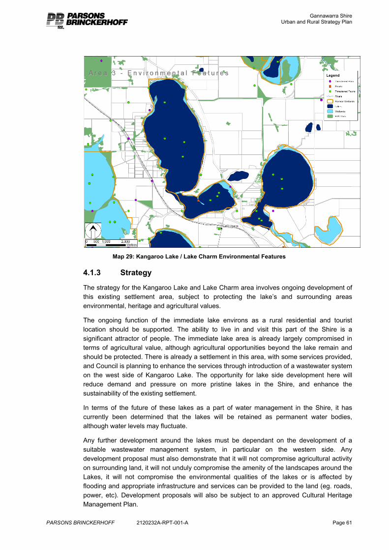
Gannawarra Shire Urban and Rural Strategy Plan
PARSONS BRINCKERHOFF 2120232A-RPT-001-A Page 61
Map 29: Kangaroo Lake / Lake Charm Environmental Features
4.1.3 Strategy
The strategy for the Kangaroo Lake and Lake Charm area involves ongoing development of this existing settlement area, subject to protecting the lake’s and surrounding areas environmental, heritage and agricultural values.
The ongoing function of the immediate lake environs as a rural residential and tourist location should be supported. The ability to live in and visit this part of the Shire is a significant attractor of people. The immediate lake area is already largely compromised in terms of agricultural value, although agricultural opportunities beyond the lake remain and should be protected. There is already a settlement in this area, with some services provided, and Council is planning to enhance the services through introduction of a wastewater system on the west side of Kangaroo Lake. The opportunity for lake side development here will reduce demand and pressure on more pristine lakes in the Shire, and enhance the sustainability of the existing settlement.
In terms of the future of these lakes as a part of water management in the Shire, it has currently been determined that the lakes will be retained as permanent water bodies, although water levels may fluctuate.
Any further development around the lakes must be dependant on the development of a suitable wastewater management system, in particular on the western side. Any development proposal must also demonstrate that it will not compromise agricultural activity on surrounding land, it will not unduly compromise the amenity of the landscapes around the Lakes, it will not compromise the environmental qualities of the lakes or is affected by flooding and appropriate infrastructure and services can be provided to the land (eg. roads, power, etc). Development proposals will also be subject to an approved Cultural Heritage Management Plan.
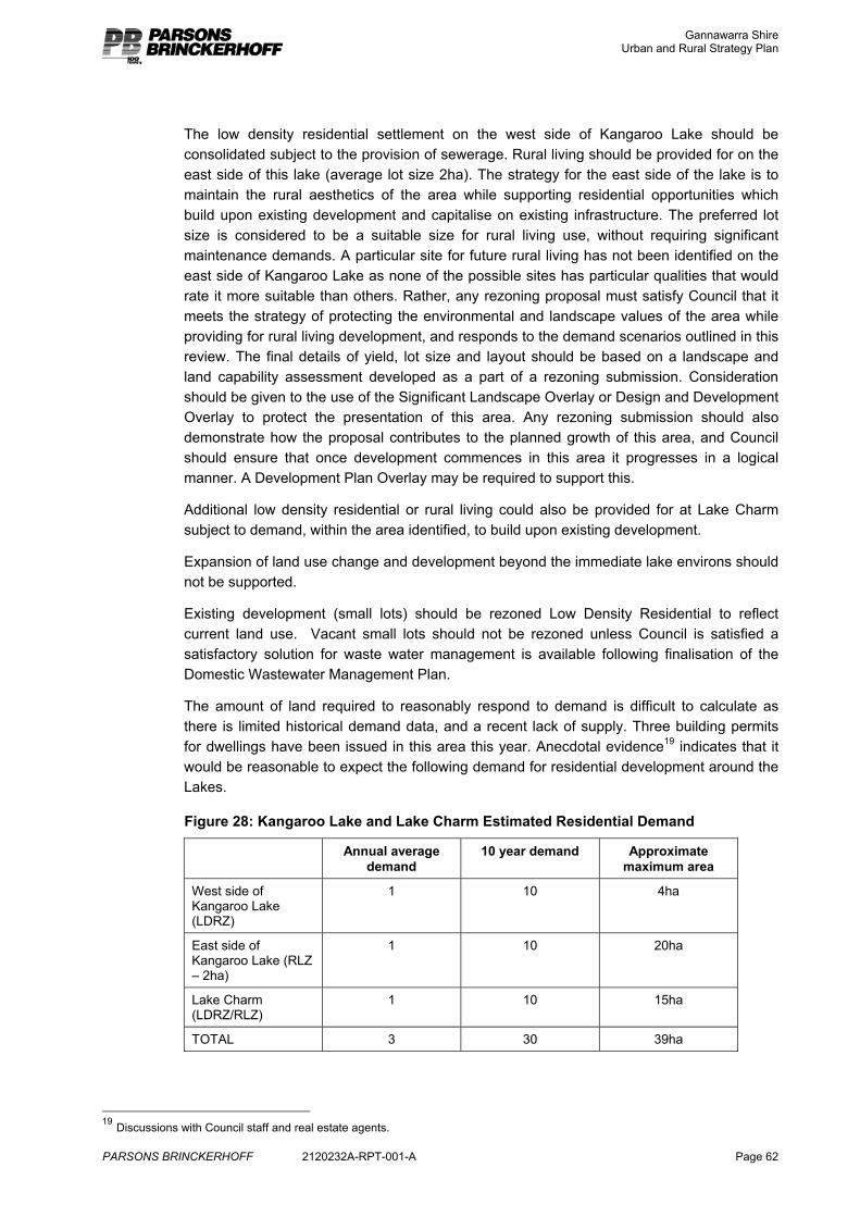
Gannawarra Shire Urban and Rural Strategy Plan
PARSONS BRINCKERHOFF 2120232A-RPT-001-A Page 62
The low density residential settlement on the west side of Kangaroo Lake should be consolidated subject to the provision of sewerage. Rural living should be provided for on the east side of this lake (average lot size 2ha). The strategy for the east side of the lake is to maintain the rural aesthetics of the area while supporting residential opportunities which build upon existing development and capitalise on existing infrastructure. The preferred lot size is considered to be a suitable size for rural living use, without requiring significant maintenance demands. A particular site for future rural living has not been identified on the east side of Kangaroo Lake as none of the possible sites has particular qualities that would rate it more suitable than others. Rather, any rezoning proposal must satisfy Council that it meets the strategy of protecting the environmental and landscape values of the area while providing for rural living development, and responds to the demand scenarios outlined in this review. The final details of yield, lot size and layout should be based on a landscape and land capability assessment developed as a part of a rezoning submission. Consideration should be given to the use of the Significant Landscape Overlay or Design and Development Overlay to protect the presentation of this area. Any rezoning submission should also demonstrate how the proposal contributes to the planned growth of this area, and Council should ensure that once development commences in this area it progresses in a logical manner. A Development Plan Overlay may be required to support this.
Additional low density residential or rural living could also be provided for at Lake Charm subject to demand, within the area identified, to build upon existing development.
Expansion of land use change and development beyond the immediate lake environs should not be supported.
Existing development (small lots) should be rezoned Low Density Residential to reflect current land use. Vacant small lots should not be rezoned unless Council is satisfied a satisfactory solution for waste water management is available following finalisation of the Domestic Wastewater Management Plan.
The amount of land required to reasonably respond to demand is difficult to calculate as there is limited historical demand data, and a recent lack of supply. Three building permits for dwellings have been issued in this area this year. Anecdotal evidence19 indicates that it would be reasonable to expect the following demand for residential development around the Lakes.
Figure 28: Kangaroo Lake and Lake Charm Estimated Residential Demand
Annual average demand
10 year demand Approximate maximum area
West side of Kangaroo Lake (LDRZ)
1 10 4ha
East side of Kangaroo Lake (RLZ – 2ha)
1 10 20ha
Lake Charm (LDRZ/RLZ)
1 10 15ha
TOTAL 3 30 39ha
19 Discussions with Council staff and real estate agents.
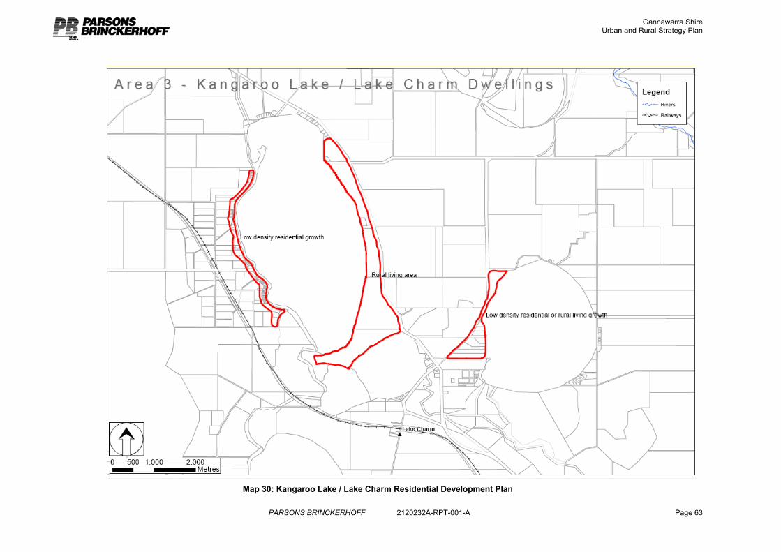
Gannawarra Shire Urban and Rural Strategy Plan
PARSONS BRINCKERHOFF 2120232A-RPT-001-A Page 63
Map 30: Kangaroo Lake / Lake Charm Residential Development Plan
Gannawarra Shire Urban and Rural Strategy Plan
PARSONS BRINCKERHOFF 2120232A-RPT-001-A Page 64
4.2 Along the Gunbower Creek north and south east of Cohuna The Gunbower Creek is an anabranch of the Murray River. It provides another attractive water frontage in the Shire, and water body for agriculture use. Sandwiched between the creek and the main body of the Murray River, is Gunbower Island. Although most of Gunbower Island is public land, there is an area of private land along the east side of the Gunbower Creek, which is subject to high demand for rural residential development. The Gunbower State Forest is the second largest Red Gum forest in the State, and is also a significant wetland area.
This area is an important agricultural area, tourist attraction and already includes some residential development due to its high amenity in some areas. Beyond Cohuna, land in this area is mostly zoned Farming.
4.2.1 Land Audit
There is a lower level of constraint to residential development along the Gunbower Creek, compared to the Murray River, due to the lower flooding risk. Unfortunately there is no digital soils data to enable an assessment of land capability for effluent disposal on Gunbower Island.
Notes on the approach to the residential constraints analysis are included in Appendix A.
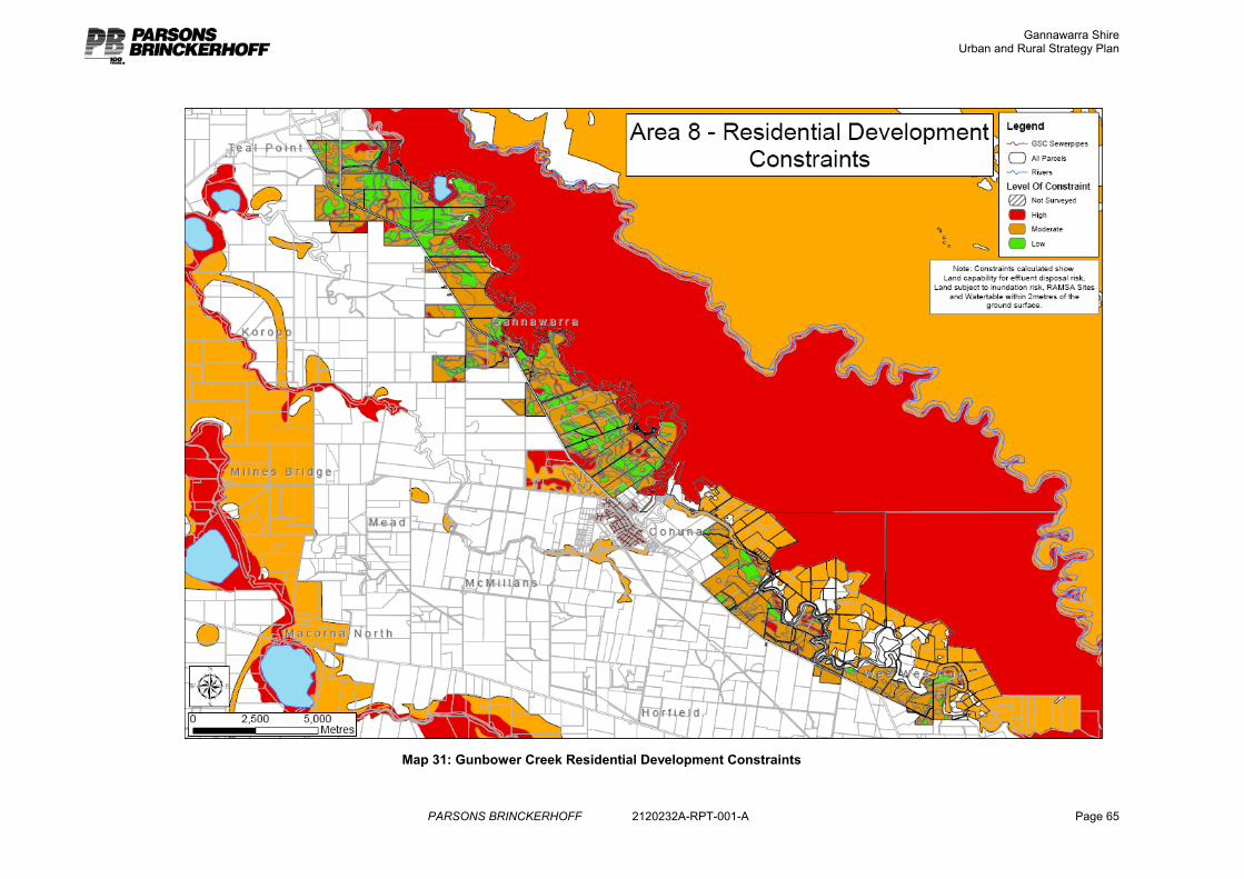
Gannawarra Shire Urban and Rural Strategy Plan
PARSONS BRINCKERHOFF 2120232A-RPT-001-A Page 65
Map 31: Gunbower Creek Residential Development Constraints
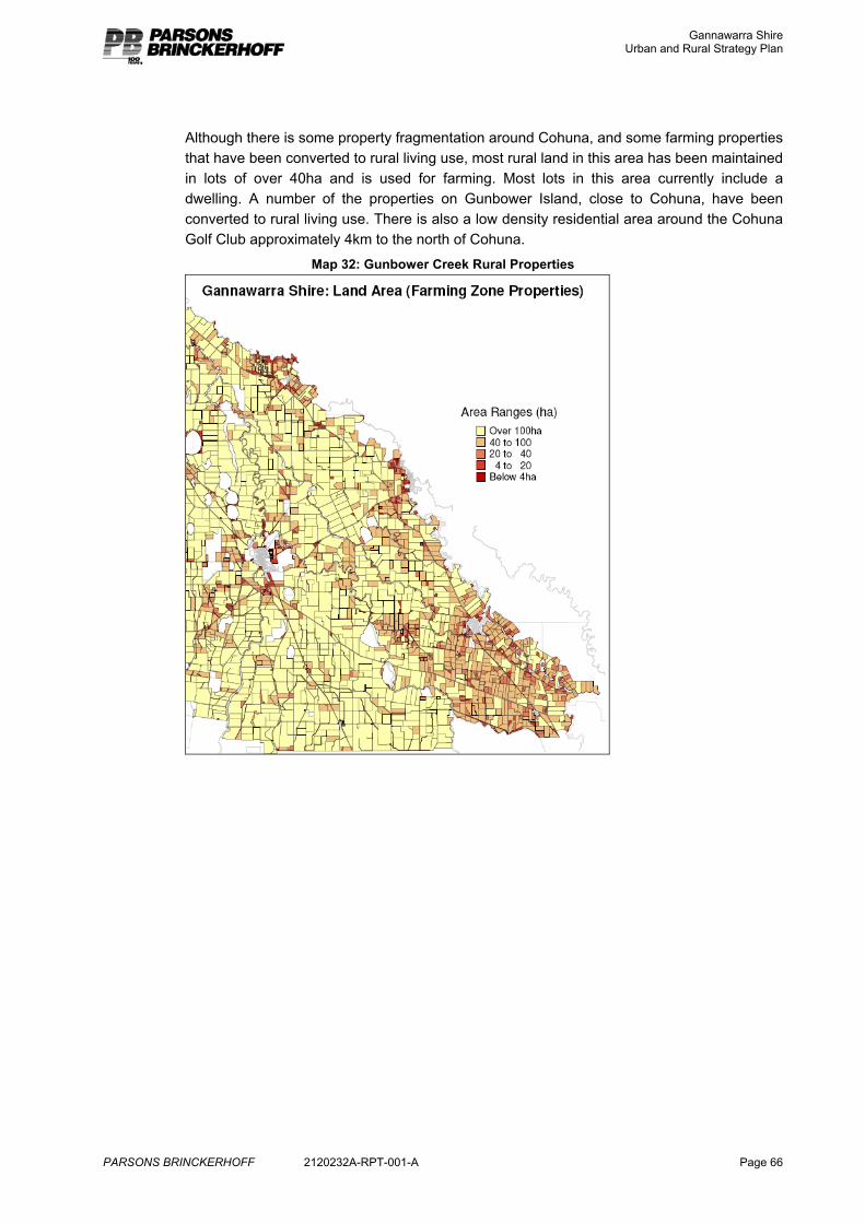
Gannawarra Shire Urban and Rural Strategy Plan
PARSONS BRINCKERHOFF 2120232A-RPT-001-A Page 66
Although there is some property fragmentation around Cohuna, and some farming properties that have been converted to rural living use, most rural land in this area has been maintained in lots of over 40ha and is used for farming. Most lots in this area currently include a dwelling. A number of the properties on Gunbower Island, close to Cohuna, have been converted to rural living use. There is also a low density residential area around the Cohuna Golf Club approximately 4km to the north of Cohuna.
Map 32: Gunbower Creek Rural Properties
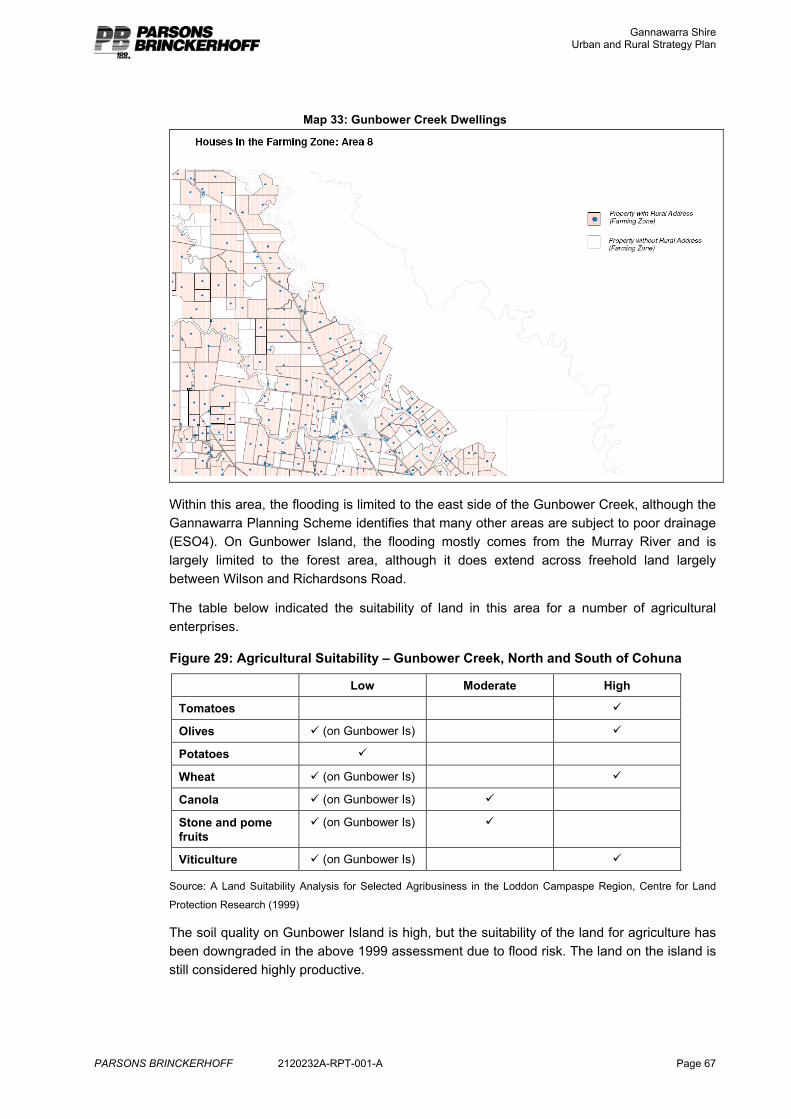
Gannawarra Shire Urban and Rural Strategy Plan
PARSONS BRINCKERHOFF 2120232A-RPT-001-A Page 67
Map 33: Gunbower Creek Dwellings
Within this area, the flooding is limited to the east side of the Gunbower Creek, although the Gannawarra Planning Scheme identifies that many other areas are subject to poor drainage (ESO4). On Gunbower Island, the flooding mostly comes from the Murray River and is largely limited to the forest area, although it does extend across freehold land largely between Wilson and Richardsons Road.
The table below indicated the suitability of land in this area for a number of agricultural enterprises.
Figure 29: Agricultural Suitability – Gunbower Creek, North and South of Cohuna
Low Moderate High
Tomatoes 9
Olives 9 (on Gunbower Is) 9
Potatoes 9
Wheat 9 (on Gunbower Is) 9
Canola 9 (on Gunbower Is) 9
Stone and pome fruits
9 (on Gunbower Is) 9
Viticulture 9 (on Gunbower Is) 9
Source: A Land Suitability Analysis for Selected Agribusiness in the Loddon Campaspe Region, Centre for Land
Protection Research (1999)
The soil quality on Gunbower Island is high, but the suitability of the land for agriculture has been downgraded in the above 1999 assessment due to flood risk. The land on the island is still considered highly productive.
Gannawarra Shire Urban and Rural Strategy Plan
PARSONS BRINCKERHOFF 2120232A-RPT-001-A Page 68
There are also considerable areas identified as highly suitable for irrigated crops based on soil type along the west side of the Gunbower Creek, north and south of Cohuna20.
4.2.2 Constraint definition
As mentioned above, Gunbower State Forest is classified as a significant wetland. It is classified as a Ramsar Wetland (listed under the International Convention on Wetlands), an Important Wetland in Australia and a Rare Wetland21. Any development in this area must include consideration of the potential impact on the adjoining wetland’s values.
Minister’s Direction No.6 and the Rural Residential Guidelines (2006) state that a proposal must not impact on the cultural or natural heritage values of the area.
Minister’s Direction No.6 and the Rural Residential Guidelines (2006) also advise that rural residential development should not be located on productive agricultural land. Productive agricultural land is considered to be that land which has one or more of the following characteristics;
� A present pattern of subdivision favourable for sustainable agricultural production;
� Can be used for a variety of agricultural pursuits;
� Suitable soil types;
� Suitable climatic conditions;
� Suitable water supply;
� Suitable agricultural infrastructure, in particular irrigation and drainage systems.
Much of the land within this area would be considered productive agricultural land.
Land within 200m of Gunbower Creek and Gunbower State Forest is identified as an Area of Cultural Heritage Sensitivity, as such any development proposal would be subject to a Cultural Heritage Management Plan. Some sites have already been identified around Cohuna, along the creek and in the forest. 22
20 Strategic View of Service Needs, Kerang Irrigation Region Atlas, 2006, Goulburn Murray Water 21 Strategic View of Service Needs, Kerang Irrigation Region Atlas, 2006, Goulburn Murray Water 22 AAV Gannawarra Shire Cultural Resource Grid Map, Mar 8, 2006
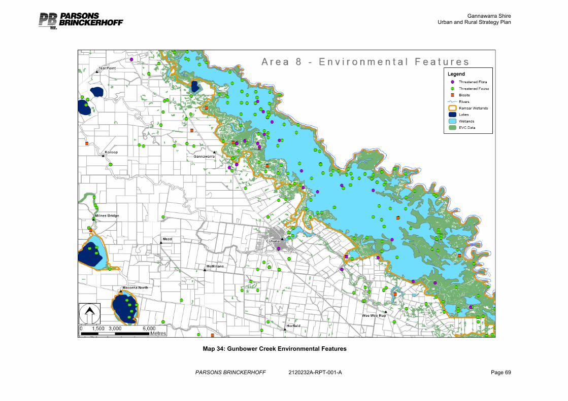
Gannawarra Shire Urban and Rural Strategy Plan
PARSONS BRINCKERHOFF 2120232A-RPT-001-A Page 69
Map 34: Gunbower Creek Environmental Features
Gannawarra Shire Urban and Rural Strategy Plan
PARSONS BRINCKERHOFF 2120232A-RPT-001-A Page 70
4.2.3 Strategy
Extensive land use change to rural living or tourism development in this area is inappropriate, but some rural living and tourism development in this area appropriately located is a reasonable strategy to support population growth and economic development.
Any rural living development should be focussed around Cohuna to be consistent with Minister’s Direction No. 6. These opportunities have been discussed earlier in this report, and consistent with indicated demand are focussed on lots of less than 2ha. No demand for 8ha lots was demonstrated and has not been planned for. Extensive rural living development throughout this area would be inconsistent with Minister’s Direction No.6 as it would unreasonably displace agriculture from productive agricultural land and may impact on the natural values of the Gunbower State Forest.
Pursuant to Minister’s Direction No. 6 rural living development must be consistent with the housing needs of the area and must be supported by and support viable and sustainable communities. Although there is no land zoned Rural Living in this area, there is currently an informal supply on Farming zoned properties with dwellings that are no longer required for farming use and these have been converted to rural living use. These are focused around Cohuna and on Gunbower Island.
Extensive further subdivision of land on Gunbower Island should not be supported as this area is more environmentally sensitive, at greater risk of flooding, and is of high landscape amenity. The majority of properties on the island are still agriculturally productive and almost all already support dwellings. An area at the eastern (Cohuna) end of the island has been identified for future rural living development.
Some rural living development could be integrated into a low density residential development to the north east of Cohuna, beyond the area required for conventional residential growth, although only small level of supply is required. Lot sizes should also be limited (generally a maximum of 2ha) to limit the amount of land lost to agriculture and improve infrastructure provision efficiency. This is also, anecdotally, the preferred lot size within the local property market.
Tourism development should be focussed around Cohuna as a preference. Rural based tourism development in this area should be managed by a local planning policy that provides guidance for the location of tourism developments within the rural areas of the Shire. It is recognised that a small number of tourist developments are appropriate for the rural areas of the Shire to capitalise on its natural assets and bring economic development to the region. These must be carefully located to protect farming activity, environmental values and to ensure appropriate services can be provided. Refer Section 5.
4.3 Along the Murray River between Myall and Benjeroop The Murray River is a key feature of this Shire, and of the State as a whole. It is an important economic and environmental asset.
This study area focuses on a farming area along the Murray in the northern part of the Shire. This area is relatively isolated and its settlements are the district of Benjeroop and the small town of Murrabit.
Gannawarra Shire Urban and Rural Strategy Plan
PARSONS BRINCKERHOFF 2120232A-RPT-001-A Page 71
4.3.1 Land Audit
There is a high level of constraint to residential development along the Murray River largely due to flooding risk.
Notes on the approach to the residential constraints analysis are included in Appendix A.
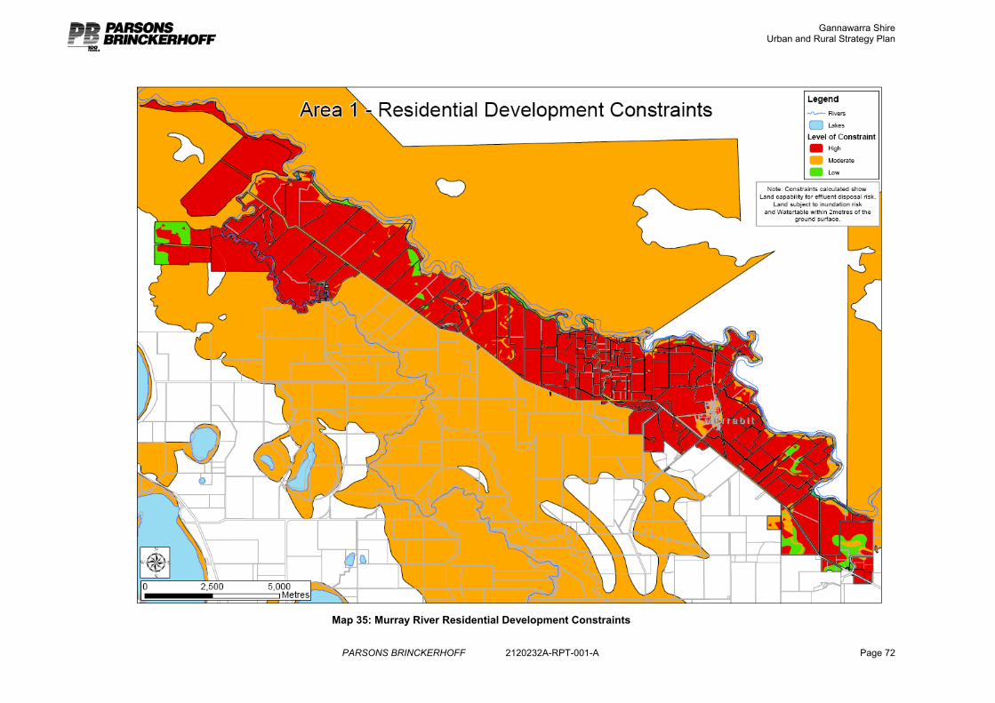
Gannawarra Shire Urban and Rural Strategy Plan
PARSONS BRINCKERHOFF 2120232A-RPT-001-A Page 72
Map 35: Murray River Residential Development Constraints
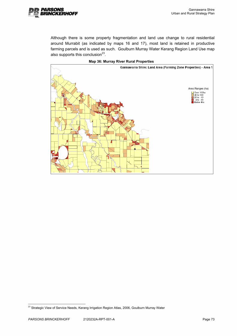
Gannawarra Shire Urban and Rural Strategy Plan
PARSONS BRINCKERHOFF 2120232A-RPT-001-A Page 73
Although there is some property fragmentation and land use change to rural residential around Murrabit (as indicated by maps 16 and 17), most land is retained in productive farming parcels and is used as such. Goulburn Murray Water Kerang Region Land Use map also supports this conclusion23.
Map 36: Murray River Rural Properties
23 Strategic View of Service Needs, Kerang Irrigation Region Atlas, 2006, Goulburn Murray Water
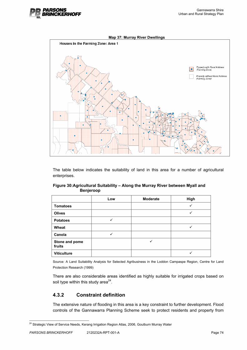
Gannawarra Shire Urban and Rural Strategy Plan
PARSONS BRINCKERHOFF 2120232A-RPT-001-A Page 74
Map 37: Murray River Dwellings
The table below indicates the suitability of land in this area for a number of agricultural enterprises.
Figure 30:Agricultural Suitability – Along the Murray River between Myall and Benjeroop
Low Moderate High
Tomatoes 9
Olives 9
Potatoes 9
Wheat 9
Canola 9
Stone and pome fruits
9
Viticulture 9
Source: A Land Suitability Analysis for Selected Agribusiness in the Loddon Campaspe Region, Centre for Land
Protection Research (1999)
There are also considerable areas identified as highly suitable for irrigated crops based on soil type within this study area24.
4.3.2 Constraint definition
The extensive nature of flooding in this area is a key constraint to further development. Flood controls of the Gannawarra Planning Scheme seek to protect residents and property from
24 Strategic View of Service Needs, Kerang Irrigation Region Atlas, 2006, Goulburn Murray Water
Gannawarra Shire Urban and Rural Strategy Plan
PARSONS BRINCKERHOFF 2120232A-RPT-001-A Page 75
the risk of flooding, maintain floodplains for the passage of floodwaters and preserve water quality by avoiding inappropriate land uses in flood prone areas.
Domestic wastewater management controls generally do not permit non reticulated effluent disposal within flood prone areas, and building controls require floor levels at 300mm above the 1 in 100 year (1%) flood level. These requirements either prevent or impose considerable additional cost for building development within these areas.
Although there are some isolated pockets of land within this study area that are not subject to flooding, development on this land is also generally not appropriate as the surrounding land is subject to flooding which affects safe access to the properties during a flood event.
Minister’s Direction No.6 and the Rural Residential Guidelines (2006) both advise that rural residential development should not be located on productive agricultural land. Productive agricultural land is considered to be that land which has one or more of the following characteristics;
� A present pattern of subdivision favourable for sustainable agricultural production;
� Can be used for a variety of agricultural pursuits;
� Suitable soil types;
� Suitable climatic conditions;
� Suitable water supply;
� Suitable agricultural infrastructure, in particular irrigation and drainage systems.
Much of the land within this area would be considered productive agricultural land.
Council’s planning strategies of the Gannawarra MSS also seek to protect farmland and support the ongoing use of rural areas for agriculture.
Land within 200m of the Murray River is identified as an Area of Cultural Heritage Sensitivity, as such any development proposal would be subject to a Cultural Heritage Management Plan. A number of sites have already been identified along the river. 25
25 AAV Gannawarra Shire Cultural Resource Grid Map, Mar 8, 2006
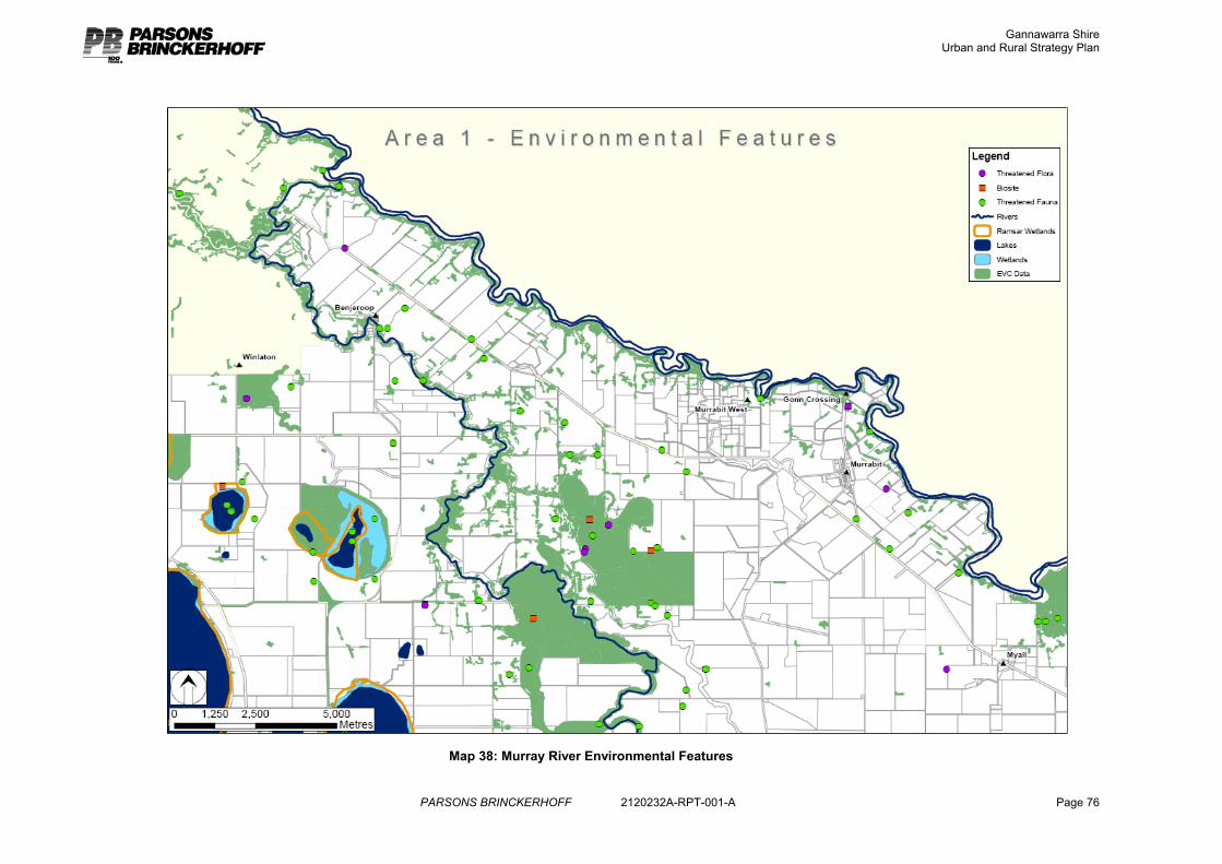
Gannawarra Shire Urban and Rural Strategy Plan
PARSONS BRINCKERHOFF 2120232A-RPT-001-A Page 76
Map 38: Murray River Environmental Features
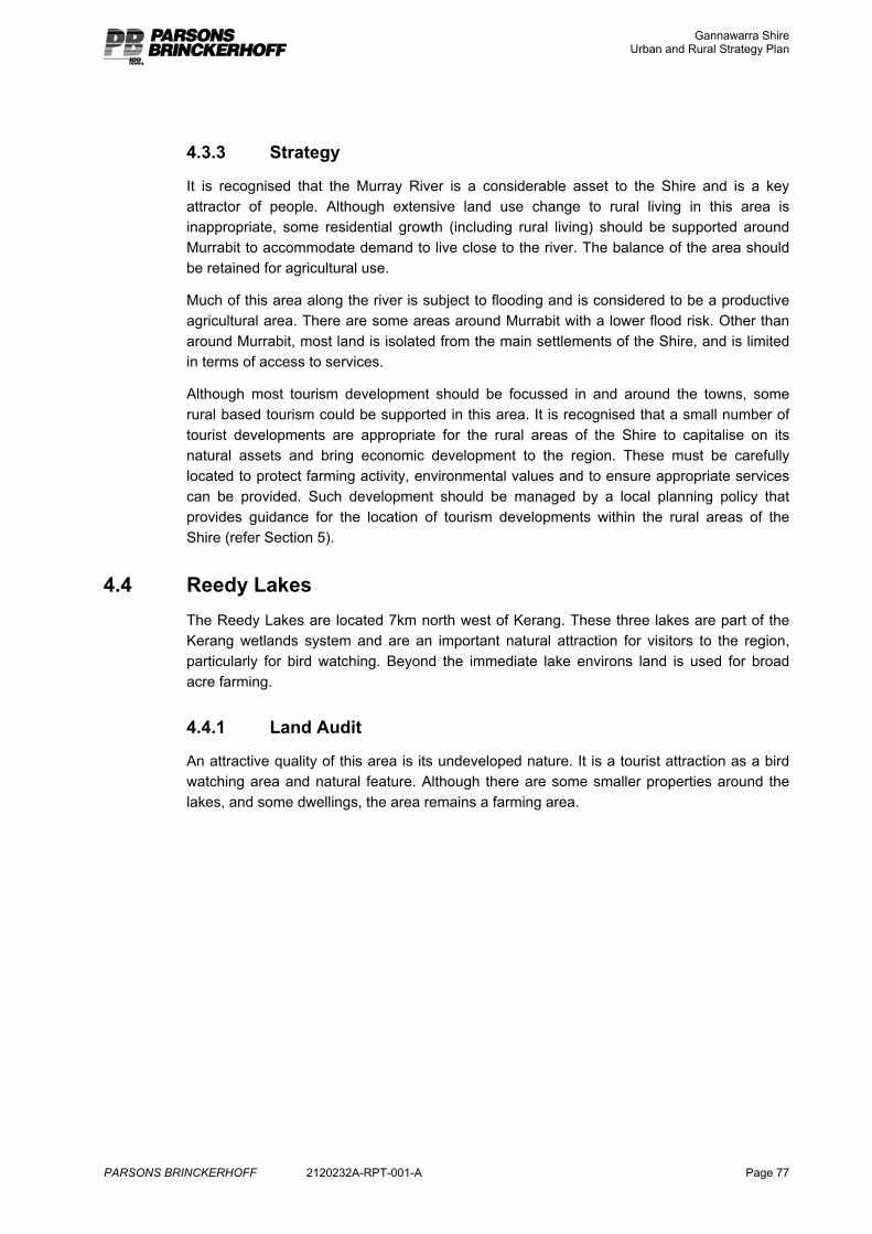
Gannawarra Shire Urban and Rural Strategy Plan
PARSONS BRINCKERHOFF 2120232A-RPT-001-A Page 77
4.3.3 Strategy
It is recognised that the Murray River is a considerable asset to the Shire and is a key attractor of people. Although extensive land use change to rural living in this area is inappropriate, some residential growth (including rural living) should be supported around Murrabit to accommodate demand to live close to the river. The balance of the area should be retained for agricultural use.
Much of this area along the river is subject to flooding and is considered to be a productive agricultural area. There are some areas around Murrabit with a lower flood risk. Other than around Murrabit, most land is isolated from the main settlements of the Shire, and is limited in terms of access to services.
Although most tourism development should be focussed in and around the towns, some rural based tourism could be supported in this area. It is recognised that a small number of tourist developments are appropriate for the rural areas of the Shire to capitalise on its natural assets and bring economic development to the region. These must be carefully located to protect farming activity, environmental values and to ensure appropriate services can be provided. Such development should be managed by a local planning policy that provides guidance for the location of tourism developments within the rural areas of the Shire (refer Section 5).
4.4 Reedy Lakes The Reedy Lakes are located 7km north west of Kerang. These three lakes are part of the Kerang wetlands system and are an important natural attraction for visitors to the region, particularly for bird watching. Beyond the immediate lake environs land is used for broad acre farming.
4.4.1 Land Audit
An attractive quality of this area is its undeveloped nature. It is a tourist attraction as a bird watching area and natural feature. Although there are some smaller properties around the lakes, and some dwellings, the area remains a farming area.
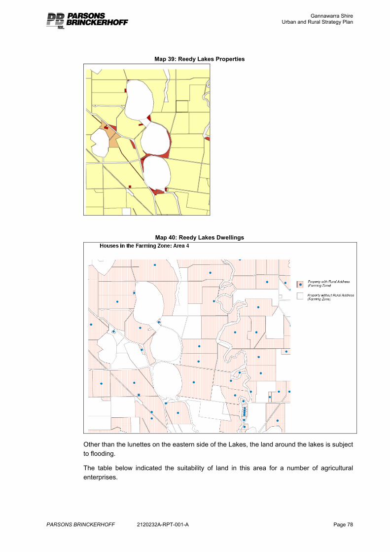
Gannawarra Shire Urban and Rural Strategy Plan
PARSONS BRINCKERHOFF 2120232A-RPT-001-A Page 78
Map 39: Reedy Lakes Properties
Map 40: Reedy Lakes Dwellings
Other than the lunettes on the eastern side of the Lakes, the land around the lakes is subject to flooding.
The table below indicated the suitability of land in this area for a number of agricultural enterprises.
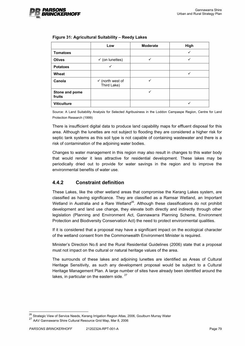
Gannawarra Shire Urban and Rural Strategy Plan
PARSONS BRINCKERHOFF 2120232A-RPT-001-A Page 79
Figure 31: Agricultural Suitability – Reedy Lakes
Low Moderate High
Tomatoes 9
Olives 9 (on lunettes) 9 9
Potatoes 9
Wheat 9
Canola 9 (north west of Third Lake)
9
Stone and pome fruits
9
Viticulture 9
Source: A Land Suitability Analysis for Selected Agribusiness in the Loddon Campaspe Region, Centre for Land
Protection Research (1999)
There is insufficient digital data to produce land capability maps for effluent disposal for this area. Although the lunettes are not subject to flooding they are considered a higher risk for septic tank systems as this soil type is not capable of containing wastewater and there is a risk of contamination of the adjoining water bodies.
Changes to water management in this region may also result in changes to this water body that would render it less attractive for residential development. These lakes may be periodically dried out to provide for water savings in the region and to improve the environmental benefits of water use.
4.4.2 Constraint definition
These Lakes, like the other wetland areas that compromise the Kerang Lakes system, are classified as having significance. They are classified as a Ramsar Wetland, an Important Wetland in Australia and a Rare Wetland26. Although these classifications do not prohibit development and land use change, they elevate both directly and indirectly through other legislation (Planning and Environment Act, Gannawarra Planning Scheme, Environment Protection and Biodiversity Conservation Act) the need to protect environmental qualities.
If it is considered that a proposal may have a significant impact on the ecological character of the wetland consent from the Commonwealth Environment Minister is required.
Minister’s Direction No.6 and the Rural Residential Guidelines (2006) state that a proposal must not impact on the cultural or natural heritage values of the area.
The surrounds of these lakes and adjoining lunettes are identified as Areas of Cultural Heritage Sensitivity, as such any development proposal would be subject to a Cultural Heritage Management Plan. A large number of sites have already been identified around the lakes, in particular on the eastern side. 27
26 Strategic View of Service Needs, Kerang Irrigation Region Atlas, 2006, Goulburn Murray Water 27 AAV Gannawarra Shire Cultural Resource Grid Map, Mar 8, 2006
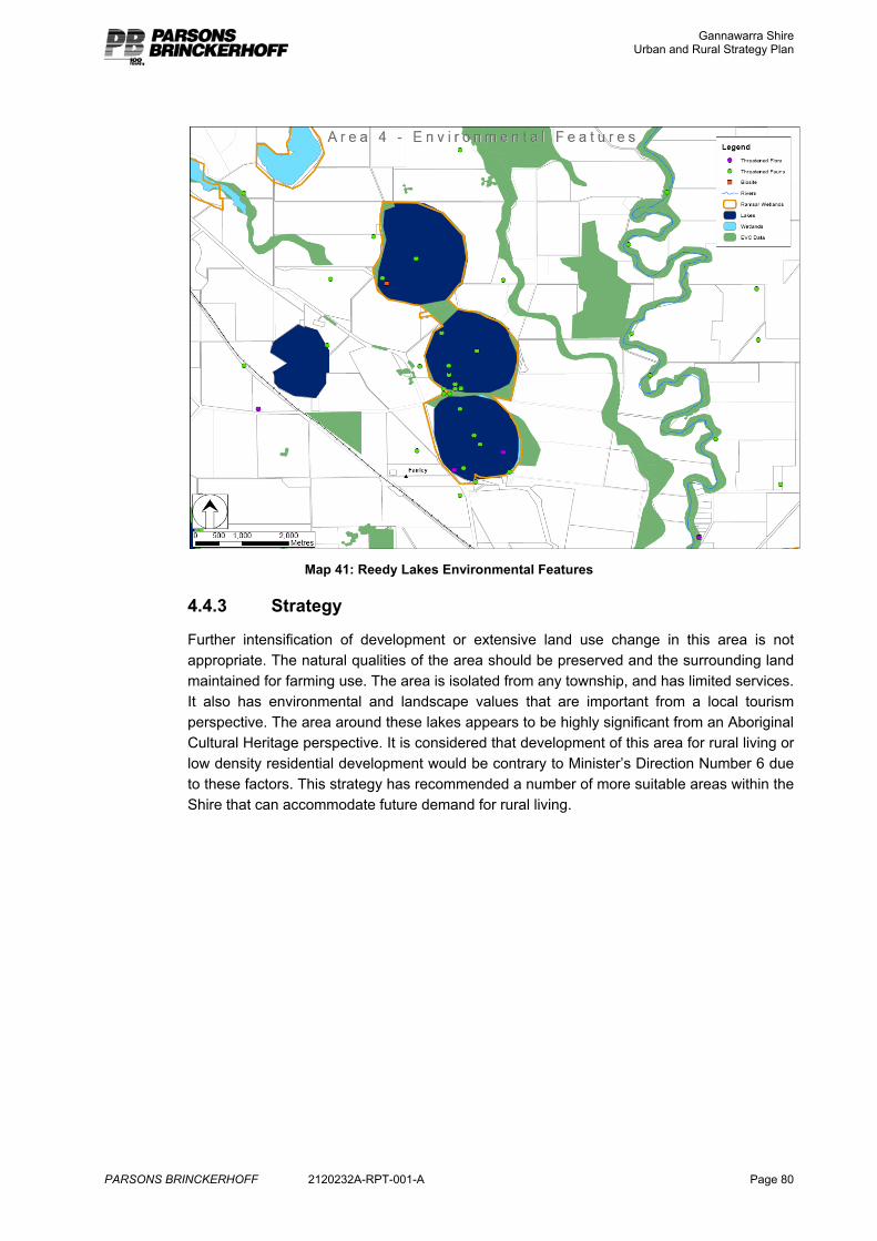
Gannawarra Shire Urban and Rural Strategy Plan
PARSONS BRINCKERHOFF 2120232A-RPT-001-A Page 80
Map 41: Reedy Lakes Environmental Features
4.4.3 Strategy
Further intensification of development or extensive land use change in this area is not appropriate. The natural qualities of the area should be preserved and the surrounding land maintained for farming use. The area is isolated from any township, and has limited services. It also has environmental and landscape values that are important from a local tourism perspective. The area around these lakes appears to be highly significant from an Aboriginal Cultural Heritage perspective. It is considered that development of this area for rural living or low density residential development would be contrary to Minister’s Direction Number 6 due to these factors. This strategy has recommended a number of more suitable areas within the Shire that can accommodate future demand for rural living.
Gannawarra Shire Urban and Rural Strategy Plan
PARSONS BRINCKERHOFF 2120232A-RPT-001-A Page 81
5. Tourism Tourism is an important and growing part of the local economy. The tourism attractions of the area include water sports, fishing, bird watching and other activities associated with the natural features and waterways of the area.
It has been identified through research and interviews conducted for this study that there is a lack of adequate tourist accommodation in the Shire at certain times of the year. It is considered that it is appropriate to plan for some additional tourist facilities both in the urban and rural areas of the Shire.
The strategy for tourism development in the Shire should involve focusing most tourism development in and around existing townships, and some potential sites have been identified at Kerang and Cohuna. In addition, it is recognised that there is the need for some rural based tourism to capitalise on natural assets. Where is it compatible with the rural character and is based on the rural or environmental features of the area some tourist development should also be supported within rural areas.
Tourism in rural areas should be carefully managed to ensure that it requires a rural site, and the rural site has not just been chosen as the cheaper land option. The following criteria should be applied to any approval for rural tourism development:
� Demonstrated need and market demand for the facility.
� The facility requires a rural location and is a rural land use.
� The facility builds on and contributes to local attractions and the tourist economy.
� The facility will not compromise agricultural activity on adjoining land.
� The facility is designed to minimise the amount of land lost to agriculture.
� The facility will not compromise environmental values and features, and should enhance them.
� The facility is of a rural character.
� The facility can be provided with the necessary infrastructure and service, in particular waste water can be appropriately managed.
Gannawarra Shire Urban and Rural Strategy Plan
PARSONS BRINCKERHOFF 2120232A-RPT-001-A Page 82
6. Conclusion The objective of this project is to ensure that Gannawarra Shire is well positioned to capitalise on its natural attractions and current “tree change” population trends and provide opportunities for new residents and visitors within its towns and rural areas to enjoy a high quality lifestyle. Council is actively promoting the lifestyle qualities of the municipality to attract new residents.
Shire building data indicates that over the past 10 years 234 new dwellings have been constructed, with stronger growth in more recent years. Although the overall population of the Shire may have decreased, much of the population loss has been from rural areas and smaller towns. Assessment of population change in Gannawarra at the Shire level misses the local trends and opportunities. Koondrook has experienced growth in population, households and new housing development. Kerang has experienced an average of 10 new houses being constructed over the past 5 years. Cohuna has also experienced a similar level of building development, as well as a growth in household numbers. Although Cohuna has continued to loose population, Council believes that there is an unmet demand in this part of the Shire for low density residential growth. This is supported with recent land sales and building development. Economic development in this part of the Shire is also strong, with a number of local businesses growing strongly. Murrabit is another settlement that Council believes has potential and has been hindered in growth through lack of suitable supply.
Council believes that there will be ongoing strong residential demand in these townships because of population shift within the Shire from smaller towns and rural areas as well as population shift from beyond the Shire, the relatively cheaper cost of housing in these towns, the high amenity and good services offered and the redirection of demand from more isolated rural areas to the planned growth areas. This strategy seeks to respond to this demand.
This strategy plans to accommodate growth and stimulate or attract additional growth through the ability to live in unique environments. The strategy plans for 34 new dwellings per annum over a 10 year period, from medium density to rural living across the Shire.
The project has developed strategies to provide for residential growth at a range of densities in attractive locations in and around a number of the towns of the Shire. In particular the strategy supports a supply of rural living land at Murrabit, Kangaroo Lake/Lake Charm and Koondrook to direct demand for this form of land use and protect environmentally and agriculturally significant areas. It is considered that growth may have been lost from the Shire due to the inability to enjoy this form of residential development in the past.
The areas for growth that have been nominated are those that have least environmental constraint, and are able to offer the best access to a range of infrastructure and services, a critical driver of growth in itself. Focussing opportunities for growth into and around the existing settlements enhances the liveability of these new growth areas, promotes of the ongoing viability of the existing settlements and preserves the amenity and viability of the rural areas.
Gannawarra Shire Urban and Rural Strategy Plan
PARSONS BRINCKERHOFF 2120232A-RPT-001-A Page 83
Summary of Anticipated Demand and Proposed Planning Actions
10 year anticipated demand and planned supply
Town / Locality
Residential development
type Dwellings Approximate
land area (lots only)
Strategy
Conventional dwellings (avg. lot size 1000m2)
50
5ha
Units (medium density avg. lot size 500m2)
25 1.25ha
Kerang
Low density residential (avg. lot size 4000m2)
25
10ha
Existing zoned supply in and around the town is sufficient for this anticipated growth. An area has been set aside for growth beyond this time period as future demand may require.
Unsuitable residential land to the north of the town should be backzoned to provide a small rural living supply.
Conventional dwellings (avg. lot size 1000m2)
50
5ha
Units (medium density avg. lot size 500m2)
25 1.25ha
Existing zoned supply in and around the town is sufficient for this anticipated growth. An area has been set aside for growth beyond this time period as demand requires it.
Cohuna
Low density residential (avg. lot size 4000m2)
25
10ha Cohuna currently has minimal supply of vacant low density residential land. The strategy supports providing for a maximum of 25 lots in the area to the north east of town for current growth projections. Opportunities for rural living have also been identified.
Conventional dwellings (avg. lot size 1000m2)
10 1ha Existing zoned supply in and around the town is sufficient for this anticipated growth. An area has been set aside for expansion of the Township zone as demand requires it.
Murrabit
Low density residential (avg. lot size 4000m2)
10 4ha Murrabit currently has no land available for low density residential or rural living development.
Gannawarra Shire Urban and Rural Strategy Plan
PARSONS BRINCKERHOFF 2120232A-RPT-001-A Page 84
Rural living (avg. lot size 2ha)
10 20ha The strategy supports providing a maximum of 20 lots each for low density residential and rural living development initially to accommodate demand for this form of land use in the Shire.
Growth of this area can occur should this supply be taken up.
Conventional dwellings (avg. lot size 1000m2)
30 3ha Existing supply is largely sufficient, although there are constraints to the full development of the existing supply. A small supplementation of the existing supply is appropriate through the further subdivision of low density residential properties where full servicing is available.
Low density residential (avg. lot size 4000m2)
30 12ha Koondrook currently has minimal supply of vacant low density residential land. The strategy supports providing for a maximum of 30 lots in the area to the north west of town for current growth projections.
Koondrook
Rural living (avg. lot size 2ha)
20 40ha There is no rural living land provided for at Koondrook. The strategy supports providing a maximum of 20 lots initially for rural living development to accommodate demand for this form of land use in the Shire.
Low density residential (avg. lot size 4000m2)
10 4ha Kangaroo Lake
Rural living (avg. lot size 2ha)
10 20ha
Lake Charm Low density residential (avg. lot size 4000m2) / Rural living (avg. lot size 2ha)
10 15ha
Lakeside living is a significant opportunity in Gannawarra. It should be focussed on Kangaroo Lake and Lake Charm where there is existing development and services. It should also be carefully planned to protect the environmental, landscape and agricultural values of the area. A maximum of 30 lots initially should be provided in this area for low density and rural living development.
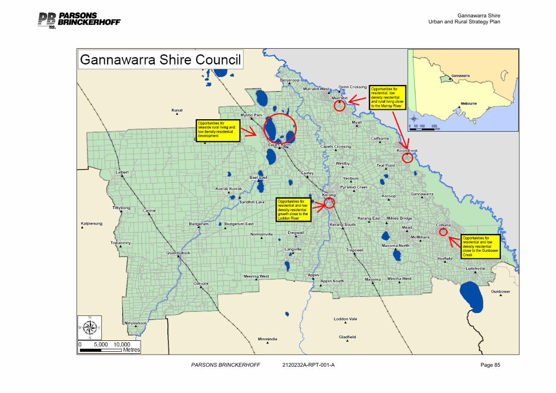
Gannawarra Shire Urban and Rural Strategy Plan
PARSONS BRINCKERHOFF 2120232A-RPT-001-A Page 85
Gannawarra Shire Urban and Rural Strategy Plan
PARSONS BRINCKERHOFF 2120232A-RPT-001-A A1
Appendix A
Notes on Residential Constraint Analysis
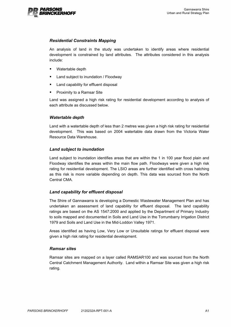
Gannawarra Shire Urban and Rural Strategy Plan
PARSONS BRINCKERHOFF 2120232A-RPT-001-A A1
Residential Constraints Mapping
An analysis of land in the study was undertaken to identify areas where residential development is constrained by land attributes. The attributes considered in this analysis include:
� Watertable depth
� Land subject to inundation / Floodway
� Land capability for effluent disposal
� Proximity to a Ramsar Site
Land was assigned a high risk rating for residential development according to analysis of each attribute as discussed below.
Watertable depth
Land with a watertable depth of less than 2 metres was given a high risk rating for residential development. This was based on 2004 watertable data drawn from the Victoria Water Resource Data Warehouse.
Land subject to inundation
Land subject to inundation identifies areas that are within the 1 in 100 year flood plain and Floodway identifies the areas within the main flow path. Floodways were given a high risk rating for residential development. The LSIO areas are further identified with cross hatching as this risk is more variable depending on depth. This data was sourced from the North Central CMA.
Land capability for effluent disposal
The Shire of Gannawarra is developing a Domestic Wastewater Management Plan and has undertaken an assessment of land capability for effluent disposal. The land capability ratings are based on the AS 1547:2000 and applied by the Department of Primary Industry to soils mapped and documented in Soils and Land Use in the Torrumbarry Irrigation District 1979 and Soils and Land Use in the Mid-Loddon Valley 1971.
Areas identified as having Low, Very Low or Unsuitable ratings for effluent disposal were given a high risk rating for residential development.
Ramsar sites
Ramsar sites are mapped on a layer called RAMSAR100 and was sourced from the North Central Catchment Management Authority. Land within a Ramsar Site was given a high risk rating.
Gannawarra Shire Urban and Rural Strategy Plan
PARSONS BRINCKERHOFF 2120232A-RPT-001-A A1
Parsons Brinckerhoff Australia Pty Ltd
ABN 80 078 004 798
IMPORTANT INFORMATION ABOUT YOUR REPORT
Scope of Services and Reliance of Data
This report has been prepared in accordance with the scope of work/services set out in the contract, or as otherwise agreed, between Parsons Brinckerhoff (PB) and the Client. In preparing this report, PB has relied upon data, surveys, analyses, designs, plans and other information provided by the Client and other individuals and organisations, most of which are referred to in the report (“the data”). Except as otherwise stated in the report, PB has not verified the accuracy or completeness of the data. To the extent that the statements, opinions, facts, information, conclusions and/or recommendations in this report (“conclusions”) are based in whole or part on the data, those conclusions are contingent upon the accuracy and completeness of the data. PB will not be liable in relation to incorrect conclusions should any data, information or condition be incorrect or have been concealed, withheld, misrepresented or otherwise not fully disclosed to PB.
Study for Benefit of Client
This report has been prepared for the exclusive benefit of the Client and no other party. PB assumes no responsibility and will not be liable to any other person or organisation for or in relation to any matter dealt with in this report, or for any loss or damage suffered by any other person or organisation arising from matters dealt with or conclusions expressed in this report (including without limitation matters arising from any negligent act or omission of PB or for any loss or damage suffered by any other party relying upon the matters dealt with or conclusions expressed in this report). Other parties should not rely upon the report or the accuracy or completeness of any conclusions and should make their own inquiries and obtain independent advice in relation to such matters.
Other Limitations
To the best of PB’s knowledge, the facts and matters described in this report reasonably represent the conditions at the time of printing of the report. However, the passage of time, the manifestation of latent conditions or the impact of future events (including a change in applicable law) may have resulted in a variation to the conditions.
PB will not be liable to update or revise the report to take into account any events or emergent circumstances or facts occurring or becoming apparent after the date of the report.