Embed Size (px)
Citation preview
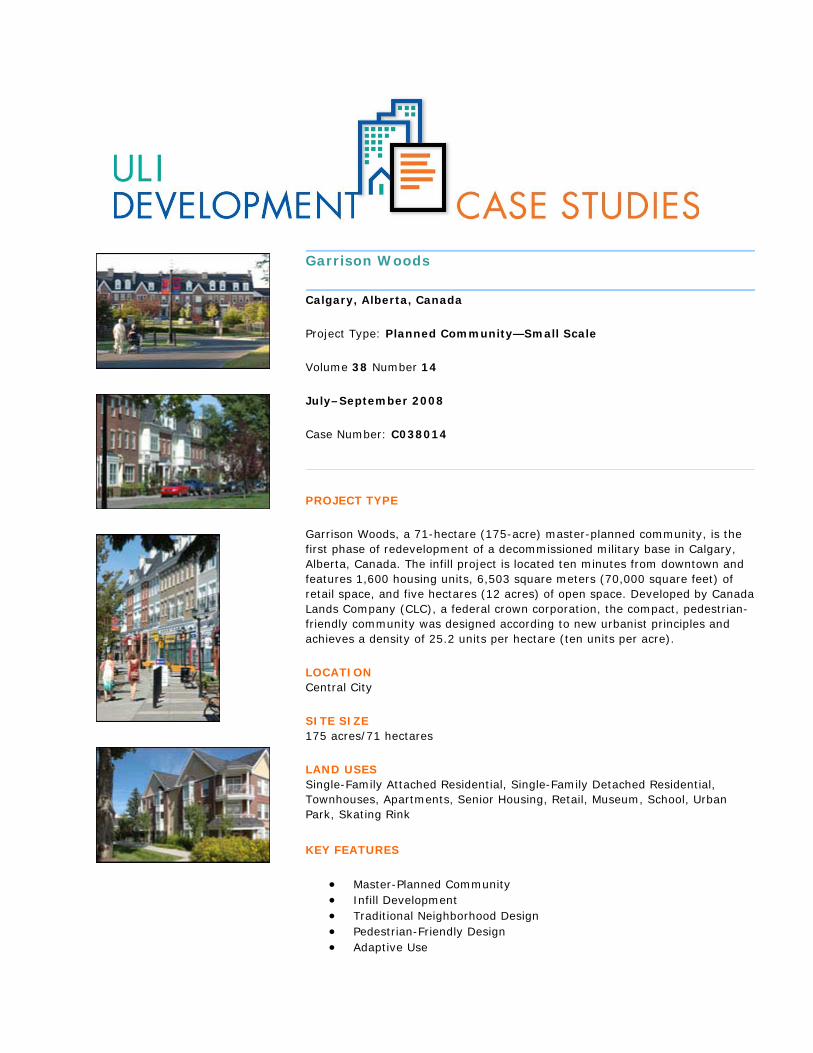
Garrison Woods
Calgary, Alberta, Canada
Project Type: Planned Community—Small Scale
Volume 38 Number 14
July–September 2008
Case Number: C038014
PROJECT TYPE
Garrison Woods, a 71-hectare (175-acre) master-planned community, is the first phase of redevelopment of a decommissioned military base in Calgary, Alberta, Canada. The infill project is located ten minutes from downtown and features 1,600 housing units, 6,503 square meters (70,000 square feet) of retail space, and five hectares (12 acres) of open space. Developed by Canada Lands Company (CLC), a federal crown corporation, the compact, pedestrian-friendly community was designed according to new urbanist principles and achieves a density of 25.2 units per hectare (ten units per acre).
LOCATION Central City
SITE SIZE 175 acres/71 hectares
LAND USES Single-Family Attached Residential, Single-Family Detached Residential, Townhouses, Apartments, Senior Housing, Retail, Museum, School, Urban Park, Skating Rink
KEY FEATURES
Master-Planned Community Infill Development Traditional Neighborhood Design Pedestrian-Friendly Design Adaptive Use
Urban Regeneration
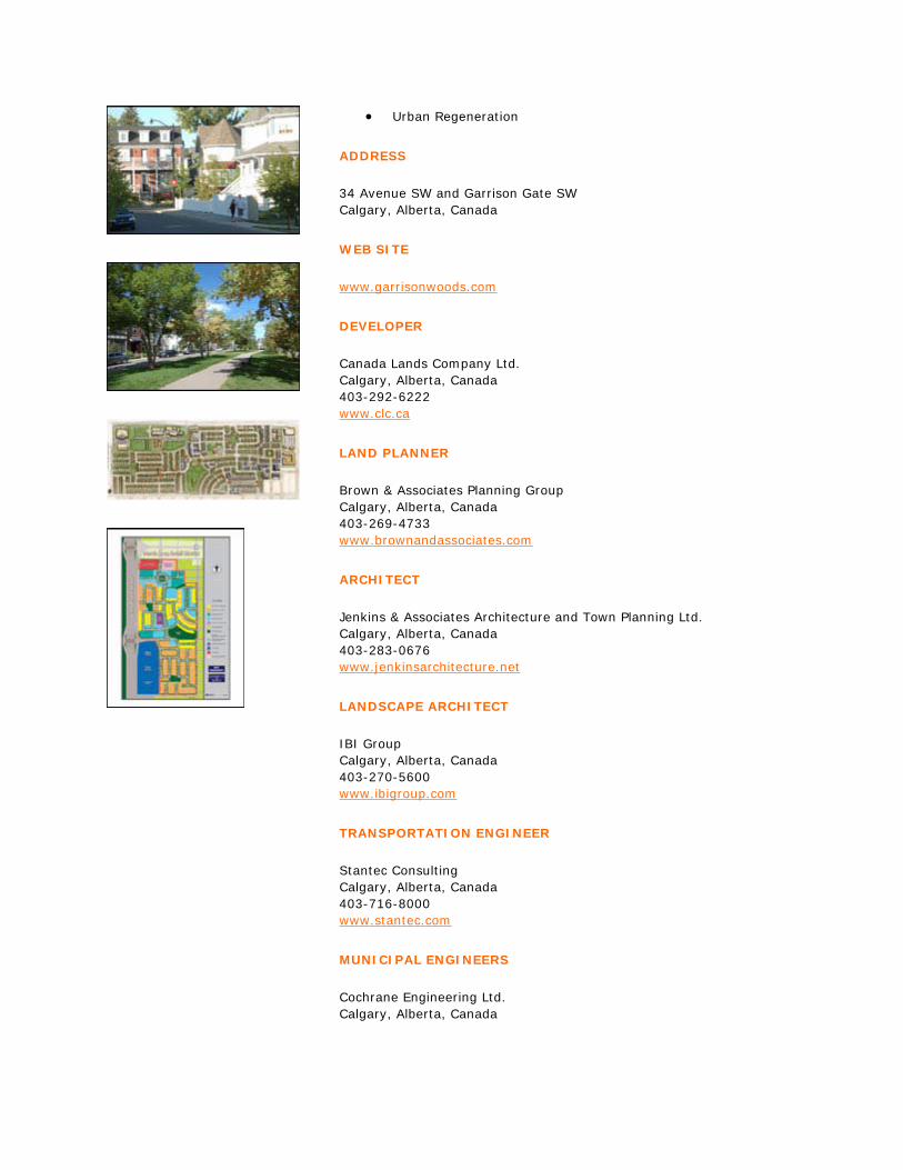
ADDRESS
34 Avenue SW and Garrison Gate SW Calgary, Alberta, Canada
WEB SITE
www.garrisonwoods.com
DEVELOPER
Canada Lands Company Ltd. Calgary, Alberta, Canada 403-292-6222 www.clc.ca
LAND PLANNER
Brown & Associates Planning Group Calgary, Alberta, Canada 403-269-4733 www.brownandassociates.com
ARCHITECT
Jenkins & Associates Architecture and Town Planning Ltd. Calgary, Alberta, Canada 403-283-0676 www.jenkinsarchitecture.net
LANDSCAPE ARCHITECT
IBI Group Calgary, Alberta, Canada 403-270-5600 www.ibigroup.com
TRANSPORTATION ENGINEER
Stantec Consulting Calgary, Alberta, Canada 403-716-8000 www.stantec.com
MUNICIPAL ENGINEERS
Cochrane Engineering Ltd. Calgary, Alberta, Canada

403-262-3638 www.cochrane-group.ca
Progressive Engineering Calgary, Alberta, Canada 403-509-3030 www.progressiveengineering.ca
GENERAL DESCRIPTION
A 71-hectare (175-acre) master-planned community, Garrison Woods is the first phase in the large-scale redevelopment of a decommissioned military base in Calgary, Alberta, Canada. Completed in 2004, the project consists of 1,600 housing units, including new single-family residences, refurbished military housing (single-family and semidetached homes), street-oriented townhouses, multifamily units, housing for seniors, apartments over retail, and a number of accessory units above garages, achieving an overall density of 25.2 units per hectare (ten units per acre). The community also contains 6,503 square meters (70,000 square feet) of neighborhood retail space, two private schools, and 4.9 hectares (12 acres) of public open space in addition to an existing ice arena and military museum.
Garrison Woods is the first of three parcels at the former Canadian Forces Base (CFB) Calgary to be redeveloped. The base closure offered an opportunity for the developer to implement new urbanist principles and sustainable community design on a central city brownfield site. The second phase is the 32.4-hectare (80-acre) sister community of Garrison Green, to be completed in 2009. The 81-hectare (200-acre) Currie Barracks, a recognized pilot project for LEED for Neighborhood Design (LEED-ND), is the final and largest phase.
The developer, Canada Lands Company (CLC), is a federal crown corporation that was created to optimize the financial and community value obtained from properties no longer required by the government of Canada. Responsible for managing and disposing of the federal government’s surplus holdings throughout the country, CLC has title to approximately 932 hectares (2,303 acres) as of August 2008. The company’s mandate is to “ensure the commercially oriented, orderly disposition of surplus properties with optimal value to the Canadian taxpayer and the holding of certain properties.”
SITE AND BACKGROUND
Approximately a ten-minute drive from the downtown core, Garrison Woods is located in the southwest quadrant of Calgary. Situated on the outer edge of Calgary’s older inner-city neighborhoods, the project lies near several major arterial roadways and Mount Royal College, as well as emerging business parks and a business revitalization zone. The site contains 63 gross developable hectares (156 acres) and links to the city’s regional open-space and pathway network. The project area is bounded by Crowchild Trail, a major expressway to the west; 20th Street SW to the east; 34th Avenue SW to the north; and 47th Avenue SW on the south.
Garrison Woods is surrounded by older, inner-city communities to the east and south that consist primarily of low-density residential development, although several new infill and multifamily projects have been constructed in these neighborhoods over the last few years. To the north of Garrison Woods, along 33rd Avenue, is the Marda Loop business revitalization zone, an older pedestrian-oriented shopping street.
The project area is relatively flat: the topography undulates gently, sloping slightly toward the south and southeast. Garrison Woods’ mature trees—50 percent deciduous, 50 percent evergreen—were planted around the time the military housing units were built. They are concentrated along the original roads and the periphery of the existing open spaces, which includes the historic Parade Square to the west (on the Currie Barracks site) and the centrally located open space inside Garrison Woods (Flanders Park).

As part of the former CFB Calgary, the Garrison Woods site has a long history within the city of Calgary. The land was used for military maneuvers as early as the 1890s, and held more formal military exercises between 1911 and 1914, when the region was known as Reservoir Park (due to its proximity to the Glenmore Reservoir). After World War II, the Department of National Defense used the Garrison Woods site for housing married army personnel, with the majority of the housing stock constructed between 1948 and 1952. The area accommodated 560 single-family and semidetached residences as well as several community facilities, including an ice arena, a military museum, a school, a community center, and two chapels.
PLANNING AND APPROVALS
In 1995, the government of Canada announced plans to close the 182-hectare (450-acre) CFB Calgary site by 1998, with the Department of National Defense retaining only a small 3.2-hectare (8-acre) footprint on the future Currie Barracks parcel. The site was acquired by CLC in 1997, and planning commenced the same year.
The CLC team for Garrison Woods and companion developments is led by Mark McCullough, who joined as general manager for Alberta in 1996. Linda Hackman began working on the project as policy planner for the city of Calgary and joined CLC as urban planner and project manager. Major design consultants for Garrison Woods were as follows: Brown & Associates Planning Group of Calgary (land planning), Calgary-based Jenkins & Associates Architecture and Town Planning Ltd. (architectural consulting and codes), as well as the international firms IBI Group (landscape architecture and marketing), Cochrane Engineering Ltd. (municipal engineering), and Stantec Consulting (transportation and municipal engineering). Calgary-based Progressive Engineering also provided municipal engineering.
For planning purposes, the military base was divided into two parts separated by Crowchild Trail. Garrison Woods is situated on the parcel (CFB East) lying east of the highway; Garrison Green and the future Currie Barracks are located on a portion of the 313.8-hectare (777-acre) property (CFB West) to the west.
The policy plans for both CFB East and CFB West were jointly funded and developed collaboratively by CLC, the cityof Calgary, and the province of Alberta (in the case of CFB West). The partners conducted an extensive public involvement process, working with citizens’ advisory committees, area residents, special interest groups, and ward aldermen to address the primary community concerns about increased traffic and density. All partners agreed on the goal of creating an intensive, pedestrian-oriented community that would honor the legacy of the military base and incorporate principles of sustainable development.
The compact, new urbanist approach to master planning and development at Garrison Woods is not entirely new to Calgary: McKenzie Towne, a new urbanist development in Calgary’s southeast suburbs, was completed in 2000. However, as a large-scale infill development in the heart of the city, Garrison Woods and its companion projects represented an unprecedented challenge to the zoning code, the design regulations, and even the construction standards of the city.
At Garrison Woods, site-specific or “custom” zoning was approved by Calgary’s city council. For example, standard frontyard setbacks were reduced in order to move buildings closer to the street; parking is accessed from rear lanes; and ground-floor units in apartment buildings are required to provide individual and direct access at grade to create a more pedestrian-friendly environment. Each aspect of the design and infrastructure required independent justification and approval, and the architectural code—designed by Jenkins & Associates Architecture and Town Planning—was adopted to complement the custom zoning package.
DESIGN
Garrison Woods represents a significant exception to the automobile-oriented, suburban-style development that has shaped Calgary and other western cities. The design of Garrison Woods is based on new urbanist principles: a traditional, compact street grid; street-oriented entries with minimal setbacks; accommodations for pedestrians along the right-of-way; and garage entrances primarily along alleys. The project is also distinguished by generous amounts of modestly scaled, well-distributed open space that contributes to the character and identity of each street and building. The urbanized streetscape accommodates cars yet emphasizes the convenience and

experience of pedestrians—traffic calming, upgraded sidewalks, customized street furniture, and pocket parks all contribute to this goal.
In addition to tying into the existing fabric of the city by providing pedestrian and vehicular connections where none previously existed, Garrison Woods is designed to complement the adjacent community in form and scale. Buildings, especially along boundary streets, reflect and complement the features of the adjacent neighborhood.
Running along the northern edge of Garrison Woods, the aforementioned Marda Loop business revitalization zone provides a variety of goods and services for local residents. To reinforce the project’s connection to this area, the north entrance to Garrison Woods contains a mix of local commercial uses, including a 4,180-square-meter (45,000-square-foot) grocery store. Adjacent to this commercial node is the medium-density residential component, in the form of street-oriented townhouses, low-rise apartments, and special housing for seniors. These are all concentrated around Garrison Square and located close to transit and shopping.
The balance of Garrison Woods is primarily residential development in the form of new and refurbished single-family residences, and rehabilitated semidetached units. Positioned in the central and southeast portions of the community, these uses ensure a compatible relationship with the adjacent low-density community. Interspersed throughout the site is higher-density multifamily housing of a compatible scale.
Garrison Woods contains institutional and recreational uses—both existing and newly constructed—in the central and southwest portions of the community. The Military Museums, a collection of seven museums situated on 5.3 hectares (13 acres) and Canada’s largest military museum outside of the nation’s capital, was retained on site. Adjacent to the museum is the existing Centennial Arenas and the newly constructed Garrison Curling Club. Two private schools are also located in Garrison Woods—Masters Academy and College and Lycée Louis Pasteur, a French school—both of which are housed in refurbished military buildings.
A variety of parks and open spaces are distributed throughout the planned community. Totaling nearly 4.8 hectares (12 acres), the park system includes a large central park (Flanders Park), a town square (Garrison Square), three smaller neighborhood parks with playground equipment, and a linear park—all linked by a continuous pathway. This greenway is part of a circulation system that connects the neighborhood to surrounding communities and to the city’s regional parks.
Flanders Park, developed mainly for passive recreation and informal play, has been sized to accommodate active playfields and an informal ice skating area if desired in the future. The western end of the park contains a playground and benches, while the eastern end consists of a small “urban forest,” which includes newly planted and relocated mature trees, as well as seating.
The road system provides important connections into the broader urban neighborhood; however, at the same time it limits the potential for shortcutting through the development. There is no direct route from the Crowchild Trail arterial on the west to 20th Street, the collector that forms the east boundary of the site. Traffic flows from the external network primarily via Garrison Boulevard, an internal traffic spine that extends from an overpass on Crowchild Trail past Flanders Park, and north through to the Marda Loop commercial area. This north–south route is visually anchored at both ends—by a traffic roundabout connecting Flanders Avenue at the south and Garrison Square at the north. Links to the area’s military history are preserved: all existing street names were retained and monuments commemorating key World War I battles were incorporated.
On some blocks, sidewalks are on only one side of the street in order to protect the mature trees on the other side; in other places, sidewalks meander around existing trees. All residential buildings—with the exception of the houses backing onto parks—are serviced by alleys. Right-of-way design features include narrower roads, one-way streets, on-street parking, continuous and wider sidewalks, raised crosswalks, curb bumpouts, and boulevard trees. Buildings are situated close to the street—often with front porches—and setbacks typically range from one to three meters (3.3 to 9.8 feet) from the property line.
The architectural codes that govern construction at Garrison Woods are based on predominant characteristics of Calgary’s older inner-city communities. The codes regulate form, material, and color choices for the planned
community. Based on historical research and photographic documentation of existing Calgary neighborhoods, four traditional styles were identified and form the basis for the codes: Colonial, Craftsman, Tudor, and Victorian. Within the confines of the traditionalist vocabulary, this “kit of parts” approach encourages cohesive streetscapes while allowing builders to create unique buildings. They also ensure that both new and refurbished construction maintains the same standard of quality through the three phases of the overall development, blending single-family with higher-density development.
While various housing types and densities are integrated throughout the neighborhood, multifamily buildings are concentrated close to transit routes along Crowchild Trail, 20th Street, and 33rd Avenue. While it is not anticipated that additional transit routes will be required, Garrison Boulevard is designed to provide opportunities for transit service through the community. A system of streets, walkways, and pathways allows for good pedestrian access to bus stops. Most homes are within a two-minute walk of a park and a four-minute walk of a bus top.
AFFORDABLE HOUSING
In the compact urban environment of Garrison Woods, there is a diverse range of housing types and affordability levels. One strategy that promotes sustainability as well as housing affordability is the reuse and refurbishment of 400 of the 560 former military housing units. While the cost savings inherent in this approach were minimal, it allowed CLC to bring some residential units into the marketplace more quickly than with new construction and to provide an immediate income stream for the ongoing development. The reuse of housing units helped provide a mix of affordability levels in the community, with pricing of refurbished units considerably lower than that of new units.
Many of the reused houses were retained in situ, while 30 percent were relocated from other parts of the site and infilled, increasing density and diversifying the streetscape. The relocation and repositioning of the existing houses involved moving every third house, then pouring two new, repositioned foundations on which two existing houses from another location would be placed. With this “three-to-four” exchange, the original housing was consolidated and made compatible with the new pattern.
As an affordable alternative to single-family housing, 60 percent of the residences in Garrison Woods are multifamily units in the form of townhouses and apartments. In addition, a number of accessory units atop garages provide smaller, more affordable dwellings.
Due to the success of Garrison Woods, the growing Calgary economy, and the location of the community, resale prices have increased dramatically, resulting in the loss of some of the initial affordability.
FINANCING
Land for Garrison Woods and companion developments was acquired by the designated developer, CLC, at fair market value, which was negotiated based upon a government appraisal and the developer’s plan for redevelopment. The costs of planning, predevelopment, and site development of Garrison Woods and companion projects were self-financed through CLC, which has extensive holdings and total gross revenues of $149 million in 2007, with a net income of $28.1 million. As a crown corporation, wholly owned by the citizens of Canada, CLC profits accrue to the government. CLC receives no special tax benefit at any level of government. Residential building construction was financed by individual builders and their lending institutions.
MARKETING AND PERFORMANCE
Phased development ensured that buyers would have a wide range of housing choices from the outset, including new single-family homes, semidetached residences, townhouses, low-rise apartments, special housing for seniors (e.g., assisted living, extended care), live/work units, suites above garages, apartments over retail, and “growhome” townhouses (i.e., where the units are sold partially finished and owners can complete components based on their incomes and needs).
From 1998 through 2003, Canada Lands Company launched a $500,000-per-year marketing campaign for Garrison Woods. It included a media campaign and ad sales in local newspapers and magazines, the preparation of collateral material and mailers, comprehensive advertising signage, and the creation of a sales center in the historic officers’ mess hall that is part of the larger development.
Residential sales in Garrison Woods began in 1999, and the lots were sold out by August 2003, when approximately 70 percent of the units were built and occupied. The project was completed in 2004, and sales have averaged approximately 300 units a year.
The Calgary real estate market has strengthened considerably since 2004, largely owing to the new oil sands extraction industry in Alberta. However, even by overall city standards, Garrison Woods has experienced a significant rise in prices, which can be attributed to demand for its product type and location.
The city of Calgary has seen numerous benefits from the development of Garrison Woods. In addition to a successful demonstration of an infill redevelopment, the city has an improved tax base, an engine for job creation, a more efficient use of land and public services as an alternative to extending new services, and the revitalization of adjacent communities.
With more infill development occurring in surrounding communities, Garrison Woods has had a catalytic effect on its surroundings. Adjacent neighborhoods were originally built out at densities of 9.9 to 14.8 units per hectare (four to six units per acre), but since the completion of Garrison Woods, these same communities have been undergoing significant redevelopment and, as a result, are experiencing increased density.
EXPERIENCE GAINED
Since completion, Garrison Woods has demonstrated that well-designed, pedestrian-oriented housing in urban neighborhoods is very attractive to the market. Design quality—especially in the public realm—contributed greatly to market acceptance of high-density development. It also contributed to the project’s acceptance among neighboring communities, so that early opponents to the plan became supporters.
The knowledge and experienced gained with Garrison Woods have been applied to the second and third phases (Garrison Green and Currie Barracks, respectively) of the military base redevelopment. Garrison Green, a portion of the CFB West parcel, will contain 1,000 housing units of various types, at a density of 33.3 units per hectare (13.5 units per acre); and the third and final phase—the 80.9-hectare (200-acre) Currie Barracks—will add another 3,200 residential units to the larger redevelopment area.
LESSONS LEARNED
In addition, the development team learned some valuable lessons that will inform its future projects:
Nearly all of the builders involved were initially opposed to the creation of architectural controls. However, the immediate success of Garrison Woods convinced builders of their value, and as a result, the codes have become more refined as the community was developed, and many builders have introduced similar designs into other suburban communities.
Despite the federal framework of funding and support, CLC continues to face local challenges in obtaining approvals for compact, pedestrian-oriented infrastructure and construction, even for the balance of the CFB Calgary redevelopment.
Experience has shown that having a policy plan in place that supports the creation of an innovative and sustainable community is not enough: development practices and standards need to be changed to ensure that the policy can be implemented comprehensively.
It is important to identify and support champions within the city administration. The developer needs to work closely with a municipal executive who has the power to override or strongly influence individual department decisions, encourage departments to work collaboratively, make such projects a high priority, resolve problems quickly, and keep the project moving forward.
There is strong and growing support among elected officials for the kind of compact, pedestrian-friendly development that Garrison Woods represents. At the same time, the approval process has become more time-consuming, confusing, and cumbersome, requiring multiple variances and interdepartmental agreements for subsequent phases of the master plan.
Infill developments like Garrison Woods face even greater barriers than greenfield sites do. Efforts to implement site-specific zoning and customization of infrastructure design, with minimal setbacks and a mix of uses, have met with limited success. Even environmental regulations have tended to thwart the goals of sustainable development. For instance, because of Flanders Park’s central location and low elevation, it must include a stormwater dry pond. Unlike some other municipalities, the city of Calgary does not allow any planting in or around the edges of a dry pond. Therefore, more advanced systems of biofiltration of water using various plant species are not permitted.
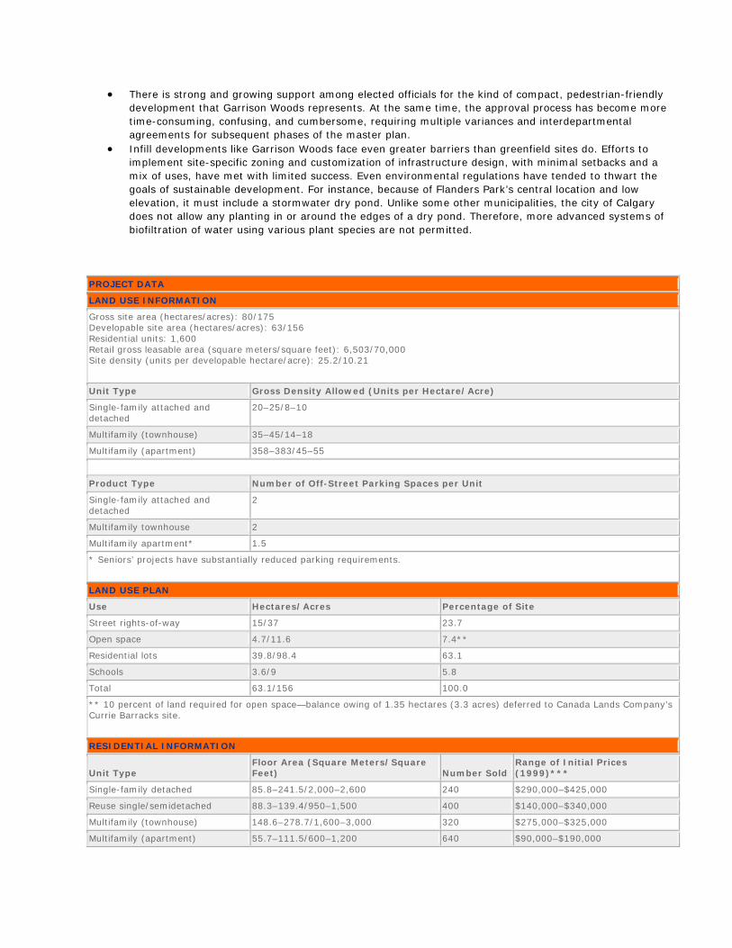
PROJECT DATA
LAND USE INFORMATION
Gross site area (hectares/acres): 80/175 Developable site area (hectares/acres): 63/156 Residential units: 1,600 Retail gross leasable area (square meters/square feet): 6,503/70,000 Site density (units per developable hectare/acre): 25.2/10.21
Unit Type Gross Density Allowed (Units per Hectare/Acre)
Single-family attached and detached
20–25/8–10
Multifamily (townhouse) 35–45/14–18
Multifamily (apartment) 358–383/45–55
Product Type Number of Off-Street Parking Spaces per Unit
Single-family attached and detached
2
Multifamily townhouse 2
Multifamily apartment* 1.5
* Seniors’ projects have substantially reduced parking requirements.
LAND USE PLAN
Use Hectares/Acres Percentage of Site
Street rights-of-way 15/37 23.7
Open space 4.7/11.6 7.4**
Residential lots 39.8/98.4 63.1
Schools 3.6/9 5.8
Total 63.1/156 100.0
** 10 percent of land required for open space—balance owing of 1.35 hectares (3.3 acres) deferred to Canada Lands Company’s Currie Barracks site.
RESIDENTIAL INFORMATION
Unit Type Floor Area (Square Meters/Square Feet) Number Sold
Range of Initial Prices (1999)***
Single-family detached 85.8–241.5/2,000–2,600 240 $290,000–$425,000
Reuse single/semidetached 88.3–139.4/950–1,500 400 $140,000–$340,000
Multifamily (townhouse) 148.6–278.7/1,600–3,000 320 $275,000–$325,000
Multifamily (apartment) 55.7–111.5/600–1,200 640 $90,000–$190,000
*** There has been significant growth in value since 1999.
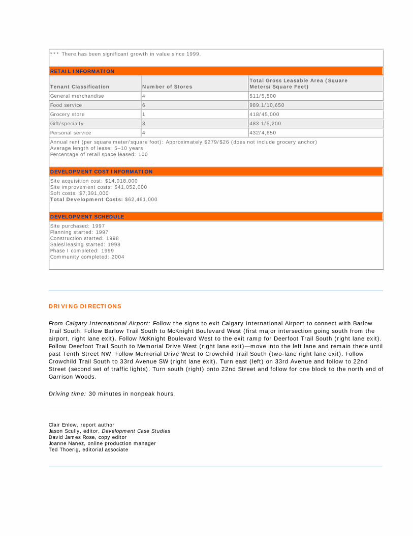
RETAIL INFORMATION
Tenant Classification Number of Stores Total Gross Leasable Area (Square Meters/Square Feet)
General merchandise 4 511/5,500
Food service 6 989.1/10,650
Grocery store 1 418/45,000
Gift/specialty 3 483.1/5,200
Personal service 4 432/4,650
Annual rent (per square meter/square foot): Approximately $279/$26 (does not include grocery anchor) Average length of lease: 5–10 years Percentage of retail space leased: 100
DEVELOPMENT COST INFORMATION
Site acquisition cost: $14,018,000 Site improvement costs: $41,052,000 Soft costs: $7,391,000 Total Development Costs: $62,461,000
DEVELOPMENT SCHEDULE
Site purchased: 1997 Planning started: 1997 Construction started: 1998 Sales/leasing started: 1998 Phase I completed: 1999 Community completed: 2004
DRIVING DIRECTIONS
From Calgary International Airport: Follow the signs to exit Calgary International Airport to connect with Barlow Trail South. Follow Barlow Trail South to McKnight Boulevard West (first major intersection going south from the airport, right lane exit). Follow McKnight Boulevard West to the exit ramp for Deerfoot Trail South (right lane exit). Follow Deerfoot Trail South to Memorial Drive West (right lane exit)—move into the left lane and remain there until past Tenth Street NW. Follow Memorial Drive West to Crowchild Trail South (two-lane right lane exit). Follow Crowchild Trail South to 33rd Avenue SW (right lane exit). Turn east (left) on 33rd Avenue and follow to 22nd Street (second set of traffic lights). Turn south (right) onto 22nd Street and follow for one block to the north end of Garrison Woods.
Driving time: 30 minutes in nonpeak hours.
Clair Enlow, report author Jason Scully, editor, Development Case Studies David James Rose, copy editor Joanne Nanez, online production manager Ted Thoerig, editorial associate
This Development Case Study is intended to serve as a resource for subscribers in improving the quality of future projects. Data contained herein were made available by the project’s development team and constitute a report on, not an endorsement of, the project by ULI–the Urban Land Institute.
Copyright © 2008 by ULI–the Urban Land Institute 1025 Thomas Jefferson Street, N.W., Suite 500 West, Washington, D.C. 20007-5201
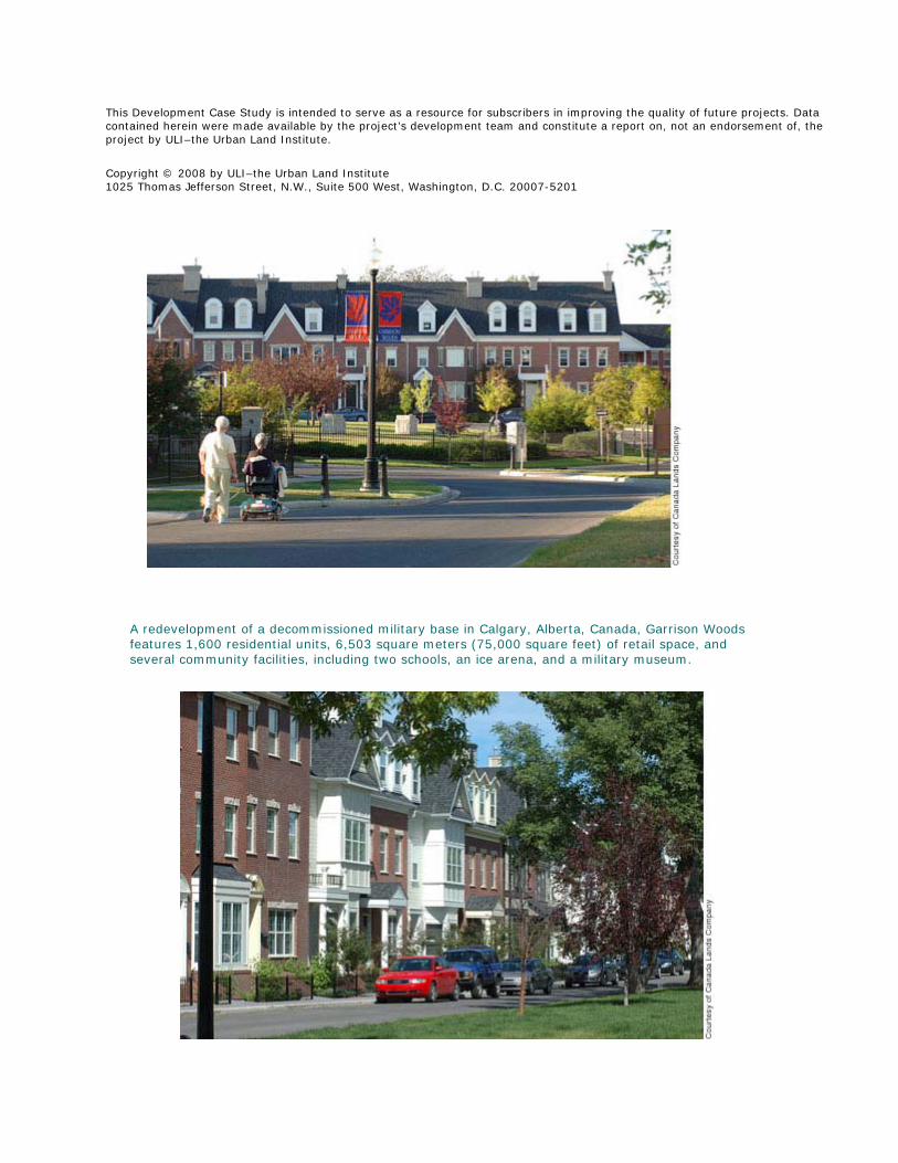
A redevelopment of a decommissioned military base in Calgary, Alberta, Canada, Garrison Woods features 1,600 residential units, 6,503 square meters (75,000 square feet) of retail space, and several community facilities, including two schools, an ice arena, and a military museum.
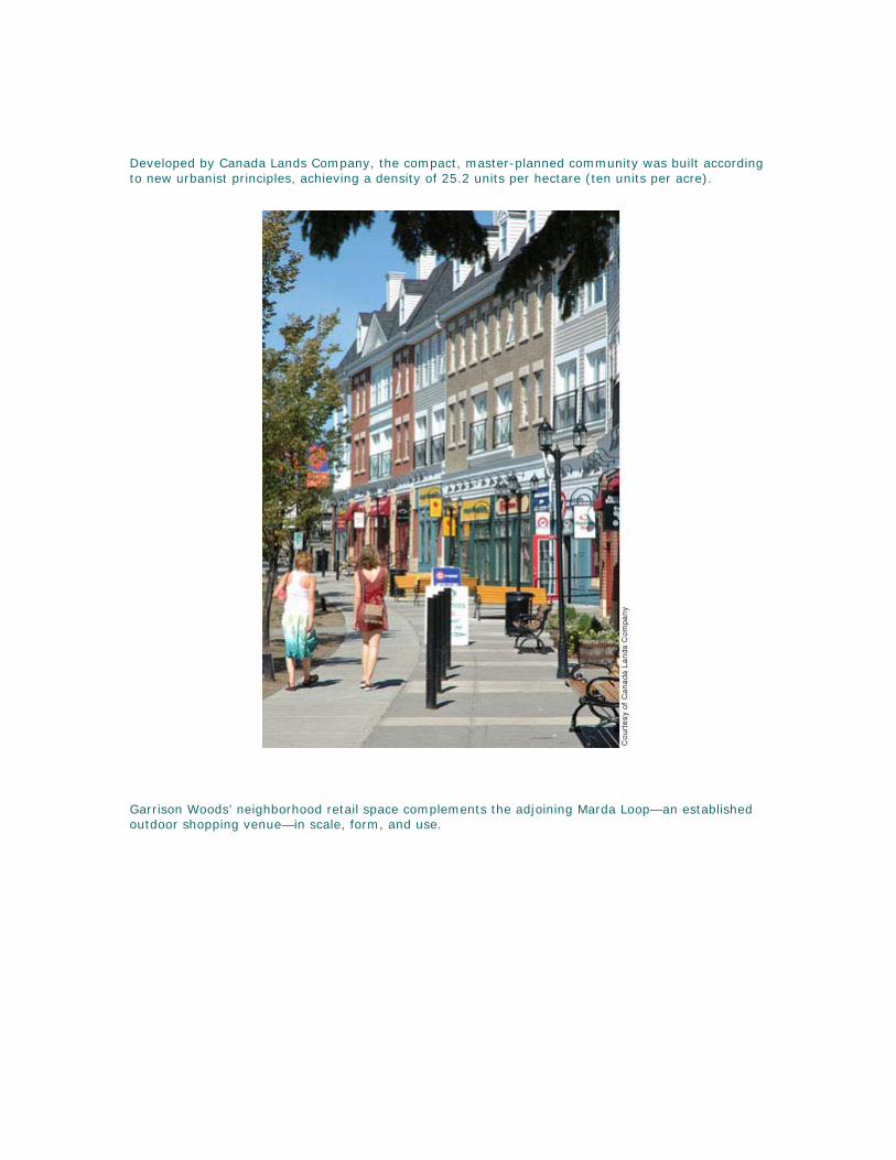
Developed by Canada Lands Company, the compact, master-planned community was built according to new urbanist principles, achieving a density of 25.2 units per hectare (ten units per acre).
Garrison Woods’ neighborhood retail space complements the adjoining Marda Loop—an established outdoor shopping venue—in scale, form, and use.

The 960 multifamily units—in both street-oriented townhouse and low-rise apartment configurations—are concentrated near the commercial zone, public square, and transit stop.
At Garrison Woods, 400 of the 560 existing military housing units were refurbished and, in some cases, relocated elsewhere on site to increase density.
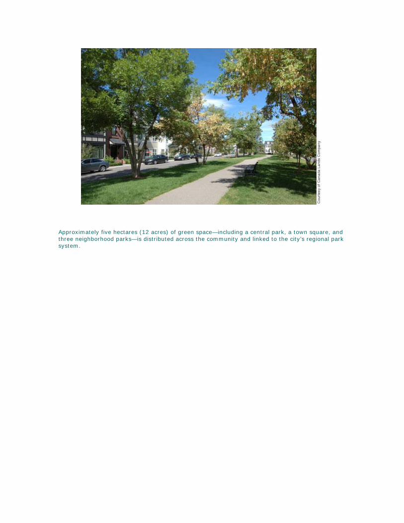
Approximately five hectares (12 acres) of green space—including a central park, a town square, and three neighborhood parks—is distributed across the community and linked to the city’s regional park system.
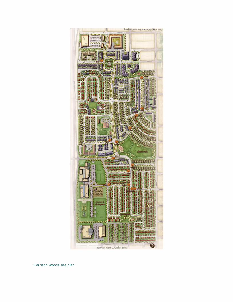
Garrison Woods site plan.
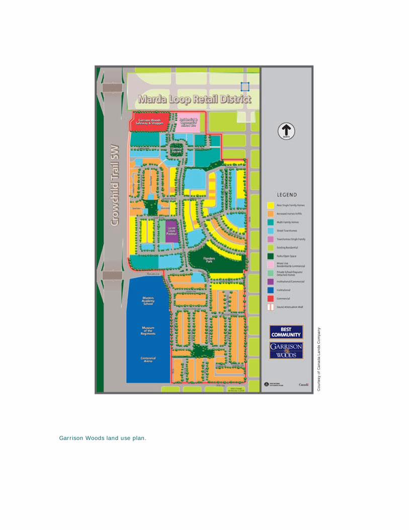
Garrison Woods land use plan.