Embed Size (px)
Citation preview

The purpose of this document is to identify a set of conceptual urban de-sign guidelines for Gateway Boulevard between 1st and 4th Avenues. These guidelines illustrate ways in which the scale and character of the Gateway Boulevard plan can be realized and the image of downtown Nashville can be enhanced.
FINAL DRAFT: 16 MARCH 2005
GATEWAY BOULEVARD DESIGN GUIDELINESMetropolitan Development and Housing Agency Metropolitan Planning Department Everton Oglesby Architects

introduction0.0 introduction0.1 introduction / glossary0.2 previous studies - subarea 9 / franklin boulevard0.3 previous studies - rolling mill hill / plan of nashville0.4 definition of site - gateway blvd0.5 vicinity map
massing1.1 frontages & setbacks1.2 height/floor-to-floor1.3 residential character1.4 development of urban character
facade 2.1 wall plane/glazing2.2 exterior cladding2.3 awnings & canopies
parking & screening3.1 surface parking/ parking structures3.2 screening requirements
index
Gateway Boulevard is being constructed as an urban “zipper,” a street that is designed to join together downtown Nashville’s urban fabric using wide sidewalks, ample medians and plantings, and travel lanes fringed with on-street parking.
When complete, the boulevard will be an axis around which the function and form of the adjacent blocks will revolve. It will be a primary corridor for vehicular traffic, to be sure, but of equal importance, Gateway Boulevard will be designed as a focal point for urban activity in Nashville - a gathering space for the city’s pedestrians and a meeting place of downtown’s various commercial and residential ambitions.
The success of urban spaces and streets is largely dependent on the shape, scale, and use of the buildings that surround them. Well-trafficked urban streets are most often lined with activity-generating uses, such as retail stores and restaurants. They are framed with structures that provide a comfortable sense of scale while reflecting the intensity and dynamism of the city. Above all, they are public displays for the diverse range of people, events, and aspirations that define an urban environment.
The guidelines contained in this document are designed to shape the buildings that will radiate from and reinforce the strength of Gateway Boulevard as a primary vehicular and pedestrian thoroughfare. The siting and massing of new buildings, the materials that clad them, the arrangement of architectural details, and the placement of access points and parking will influence the final character of the street. These guidelines attempt to form the individual buildings that, when joined together in a series of blocks, will result in a whole that is greater than the sum of its parts – an active urban space that befits the design of Gateway Boulevard itself, that bridges the urban fabric on both sides of the street, and that serves as a vital artery pulsing energy into downtown Nashville.
introduction0.0

0.1
The Pedestrian Environment
The vitality of an urban environment is largely related to the question of how buildings meet the ground plane. It is at this critical juncture between structure and public space that the character of the city’s urban fabric is established from the pedestrian point of view. The space between buildings on either side of a downtown street composes the “outdoor room” that gives people a sense of enclosure, a sense of being “in the city.” How buildings address the sidewalk and define the pedestrian realm is the true test of a successful downtown.
Historically, the downtown sidewalk was a shopper’s delight. Merchants employed large storefront windows in building after building in a sort of blocks-long showcase displaying the range of goods available to the pedestrian consumer. The facades of downtown buildings provided interesting, articulated storefronts scaled to the person on the sidewalk. But, as the retail function of downtown began to wane, the pedestrian experience of the city was gradually eroded by new buildings, devoid of the openness and detail that had formerly captured the interest of the pedestrian.
Gateway Boulevard represents a striking opportunity to strengthen the pedestrian image of Nashville’s downtown. While encouraging limitless expressions of design creativity, these guidelines focus on the critical structural elements that occur at that juncture between the building and the sidewalk. Adherence to the design concepts will encourage the sort of retail and restaurant spaces, the articulations, and the visual transparency that engender street-level activity and that help restore the importance owed to the pedestrian in the city.
introductionglossaryArcade: Covered pedestrian passageway recessed from a facadeAwning: Rooflike projection intended as protection from the elements generally appended to fenestration detailsBuild-to Line: Imaginary line that prescribes the exact placement of a building’s footprintCanopy: Like an awning, a protective projection composed of a rigid structure and a covering material such as glass or canvas Civic Building: Any building designed for community use or for public purpose including governmental, cultural, educational, public welfare, religious, or transportation-oriented structuresFrontage: Portion of a building or parcel abutting a public right-of-wayGlazing Ratio: Ratio of a façade composed of glass versus solid, opaque materialHeight Control Plane: Imaginary inclined plane that establishes the maximum height of structures on a parcel Setback: Imaginary line that prescribes the distance between a property line and the placement of a building’s footprintStreetscape Elements: Elements that contribute visually and functionally to the pedestrian environment such as benches, light poles, or bicycle racksWall Plane: The elements that compose a building façade that exist in the same plane

0.2Previous Studies/Plans
Many urban design plans have preceded this design guideline document. Acknowledging both the validity and quality of these previous efforts while also recognizing that change is a reality over time and requires constant revisiting of prior decisions, this document offers the following brief excerpts from significant previous studies/plans and their effects.
In the 1997 update to the original 1991 Subarea 9 Master Plan, a great deal of energy and focus was directed toward the character and function of the proposed Franklin Boulevard, now known as the Gateway Boulevard. The consensus decision as derived during the planning process was to mandate a pedestrian friendly urban street that would function more like a “zipper” than a “barrier” to the emerging growth area south of Broadway commonly referred to as SoBro. Images of the character envisioned along the boulevard were included in the final master plan showing a mixed-use, pedestrian-oriented, low to mid-rise scaled urban street.
subarea 9 masterplan
introduction previous studies
franklin boulevard design guidelinesFollowing the 1997 Subarea 9 Master Plan, in 1998 MDHA along with Metro Planning Commission and Metro Public Works prepared a set of Design Guidelines with the assistance of a planning consultant team.
At the request of the Mayor, the Metro Department of Public Works, Metro Planning Commission, Metro-politan Development and Housing Agency and the consultant team involved in the Subarea 9 Plan met in collaborative sessions to address the Mayor’s charge of making the Franklin Boulevard project “softer” and more balanced between pedestrian and vehicular concerns. It is an effort to ensure that this street does not become a dividing line across an area of our city that is emerging as a mixed-use pedestrian oriented neighborhood. This set of guidelines is intended to help Franklin Boulevard serve as an urban amenity, a catalyst for quality new development and a destination instead of a short cut across town. The purpose of this document is to identify a set of urban design issues and to derive design guidelines to ameliorate each issue. These guidelines illustrate ways in which the scale, character and fine-grained details of Franklin Boulevard project can be realized and the image of downtown Nashville can be enhanced through its addition to our city’s urban fabric.
Early sketch of Franklin Boulevard

0.3introduction previous studies
rolling mill hill master plan
DEVELOPMENT GUIDELINES • Require the enhancement and preservation of the historic character
of neighborhoods; new construction should relate to the character of a neighborhood but should not mimic/replicate the architecture.
• Require quality design in affordable housing that complements and enhances the character of the neighborhood.
• Require strategically placed commercial corners in neighborhoods to encourage full-service pedestrian communities.
• Require all new development to integrate with its wider surroundings and to conform to prevalent building heights in the area.
• Require the location of buildings to define street edges; parking can be easily located behind buildings.
• Require compact development and infill to maximize expenditures on infrastructure and subsequently avoid further contribution to urban sprawl.
• Increase mixed-use density along transit corridors to promote infill.• Require the change of zoning and land use regulations to reduce and/or
eliminate segmentation of land uses. Integration of land uses can encourage pedestrian-scale development.
plan of nashville guidelines
Master Plan
Once a Feasibility Study revealed the exciting potential of the site, MDHA selected a design team to explore the best options for the physical development of Rolling Mill Hill. The design team included RTKL of Washington and Everton Oglesby Architects and Hawkins Partners of Nashville. During the summer of 2003, the design team held three public meetings to solicit input from the community and ultimately produced Development Guidelines for Rolling Mill Hill, a document whose purpose is to identify the location of new infrastructure and sites for development. The Development Guidelines also propose a variety of housing types appropriate for the site, the location of new public space and greenways, historic buildings to be incorporated into future development plans, and high-quality streetscape designs. They also suggest a phasing strategy for development and stress the importance for using the renaissance of Rolling Mill Hill as a catalyst for further redevelopment in Rutledge Hill and downtown Nashville.
Overview
The Plan of Nashville, published in early 2005, is the end product of an 18-month community visioning process that addresses the design principles that should shape the development of Nashville’s urban core for decades to come. While more than 90 plans have been done for various individual parts of urban Nashville since 1950, the Plan of Nashville is the first effort to consider the central city in its entirety, addressing downtown and its surrounding neighborhoods as a cohesive whole.
Plans for the redevelopment of Rolling Mill Hill as a mixed-use community are boldly taking shape in a way that will compliment the continued resurgence of downtown Nashville. The 34-acre Rolling Mill Hill site, once home to Nashville’s General Hospital, represents a unique chance in the history of the city to create an urban neighborhood with spectacular views of the Cumberland River and the downtown skyline. Future residents of the Hill will enjoy living in close proximity to the commercial and entertainment hub of one of the South’s most dynamic urban centers.

0.4The guidelines contained in subsequent sections of this document shall immedi-ately apply to all development of property on blocks fronting Gateway Boulevard between 1st and 4th Avenues and to property located at the southeast corner of the intersection of Gateway Boulevard and Hermitage Avenue (see map above). These guidelines do not apply to properties as identified above if they are devel-oped as part of projects not fronting on or within thirty (30) feet of the Gateway Boulevard right-of-way. Additionally, these guidelines shall apply to all properties located on blocks abutting the boulevard once the preferred centerline alignment of Gateway Boulevard west of 4th Avenue South has been identified. The poten-tial impact area is illustrated on the map above.
definition of site introductionAdditionally, these guidelines should be used to evaluate development on either side of Gateway Boulevard between 1st Avenue and the Cumberland River (shaded in orange above). While existing utility easements, block length, and the river edge of these proper-ties will demand flexible application of the guidelines contained in subsequent sections of this document, new development in these locations shall meet the general design intent of the guidelines. Existing guidelines specifically developed for Rolling Mill Hill shall apply to properties located on the south face of Gateway Boulevard between the River and 1st Avenue.
- Dashed line indicates immediate extent of the Urban Design Overlay
MOLLOY
- Blue shading indicates the current extent of street improvements along the Boulevard development.
implementation The development and implementation of these guidelines has been a collaborative effort of the Metro Planning De-partment and the Metropolitan Development and Housing Agency (MDHA). Development of the guidelines involved substantial input from affected property owners and from the general public.While these guidelines will be enacted as an Urban Design Overlay (UDO), MDHA shall have the responsibility of applying the guidelines contained in this document. The initial segment of Gateway Boulevard (from the river to 4th Avenue) is located in the Rutledge Hill Redevelopment District; therefore, the Design Review Committee ap-pointed by MDHA’s Executive Director for this district will be responsible for reviewing all new development projects on Gateway Boulevard for conformance with these guide-lines. For future segments of the boulevard located in other redevelopment districts, proposed projects will be reviewed by the appropriate MDHA review body. The Planning Department will assume the responsibility for implementing these guidelines once the Redevelopment District Plan has expired. Where these guidelines prevent compliance with standards established by other agencies, MDHA and the Planning Department will cooperate with relevant agencies to develop amenable solutions that maintain the design intent of the guidelines.Each section of this document contains a statement of “General Intent.” At its discretion, the Design Review Committee may allow for deviations from the guidelines for exceptional design concepts or unusual physical constraints inasmuch as projects achieve the described general intent of the guidelines. Civic buildings present unique opportunities to introduce iconic architecture and site design into the urban fabric. Important civic structures can become focal points of a street or neighborhood. At its discretion and only when warranted by the distinctiveness of the project’s design or for purposes of functional necessity inherent to the building’s use, the Design Review Committee may allow for deviations from the guidelines for civic buildings on Gateway Boulevard. However, all civic buildings must have a primary orientation to Gateway Boulevard and must not diminish the character of the streetscape with regard to pedestrian orientation, massing, articulation, or materials.
McGAVOCK
BROADWAY
RUTLEDGE STREET
- Purple shading indicates potential extent of future Boulevard development.
- Gray shading indicates maximum future extent of the Urban Design Overlay

vicinity map
gateway boulevard
fourth avenue
shelby streetpedestrian
bridge
first avenue
N
rolling mill hilldevelopment
cumberlandriver
gateway bridge
hermitage avenue
introduction
0.5
molloy
peabody

massing
1.1 frontages & setbacks1.2 height/floor-to-floor1.3 residential character1.4 development of urban character
The design objectives outlined in this section are twofold. First, the development must establish a quality image upon entering the district. A high level of quality and design character consistent with the district should be evident. Secondly, the scale, massing and proportion of the buildings in the district should be consistent with the scale of Gateway Boulevard.

Lower left: Minimal interuptions in the building wall fronting the street may provide acess to pedestrian pathways and courtyards.
1.1frontages & setbacks (Setbacks are used in this document as minimums. Build-to lines are used as required dimensions.)
• Buildings shall have 100% frontage at a build-to line of 0 feet along Gateway Boulevard in order to create a complete building wall along the street.
• Buildings shall have 100% frontage at a build-to line of zero 0 feet along side streets perpendicular to Gateway Boulevard for a minimum distance of 30 feet from the property line fronting the boulevard. Beyond 30 feet from the boulevard, buildings may be set back from the property line, though continuous street frontage is encouraged.
• Building footprints may be required to be chamfered at corners to provide visibility at street intersections.
• No setback from the rear property line shall be required.
• Courtyards or other interruptions in the building wall along street frontages may be permitted at the discretion of the review body insofar as it is determined that they do not substantially diminish the effect of the building wall or the pedestrian character of the street. Such interruptions shall not be permitted to accomodate vehicular traffic.
massing
General Intent:In general, urban architecture should be built up to all property lines that front public thoroughfares and public space. The intent of the 100% street frontage is to promote a continuous wall plane along Gateway Boulevard to encourage density, connection to adjacent properties and street activity.
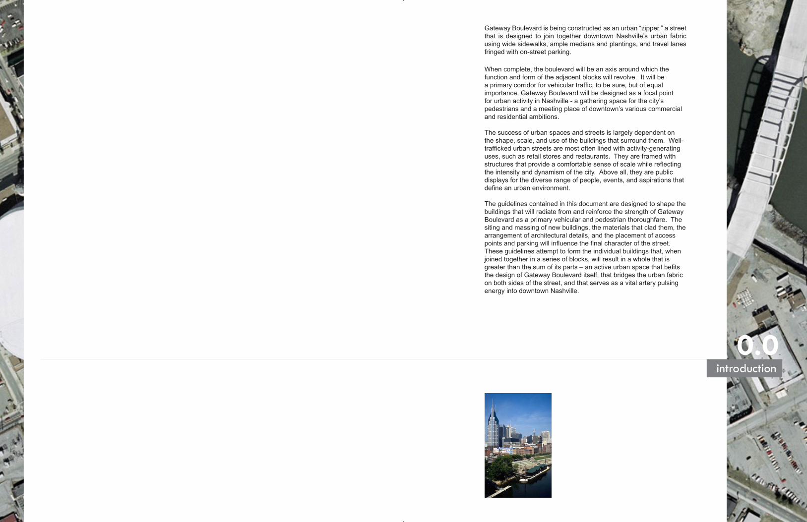
• The building height limit is 100 feet at the build-to line measured from the grade at sidewalk to the top of roof in the case of flat roofs and eave height on sloped roofs. Mechanical penthouses are not subject to this limitation. Architectural elements (towers, turrets, etc.) are encouraged.
• The building height minimum is 3 stories or 35 feet at the build-to line measured from the grade at sidewalk to the top of parapet in the case of flat roofs and eave height on sloped roofs.
• A setback of the upper stories on new structures above 100 feet is required. The height control plane regulating setback shall occur at a ratio of 1 horizontal to 2.5 vertical. After a 30 foot setback has been acheived, the height of the building is not limited by the height control plane. The height is limited only by the scale of development that may be achieved based on the floor area ratio of the base zoning requirements. • Flat roofs are acceptable. Where pitched roofs occur, a minimum slope of 3:12 is required.
• Arcades are allowed along Gateway Boulevard. The minimum arcade width is 10 feet from face of column to face of store front.
• All upper floors have a minimum floor to floor height of 10 feet. The ground floor has a minimum floor to floor height of 14 feet. • The street frontage of the ground floor of all structures shall have built-out usable space, excluding Almond Street. (ex: retail, residential or office space)
• Phased construction may be allowed per development as long as the initial phase is structured to accommodate additional floor levels and designed to meet all of the guidelines. Design reviews must include initial phase and all future design.
1.2height/floor-to-floor
General Intent:The height of the streetfront facade should relate to the width of the street right of way. The wider the street the taller the streetfront facade should be. This proportion is critical to establish the “outdoor room”. Generally, the proportion of the facade height to the right of way width should be between 1:1 and 1:2. Infill projects should generally relate to the height context established by the neighboring buildings to reinforce the perceived scale of the area.
massing
Below is an example use of the height control plane for ‘stepping back’ development from the required street edge.

1.3residential character massing
• Where residential occurs on the ground floor of a development, a maximum 8 foot setback is allowed, but not required, to accommodate entrance stoops, planters, canopies or landscaped areas. (Build-to lines shall be required for all other development).
• Residential characteristics such as elevated stoops, entrance canopies, balconies, etc. are encouraged in all residential development.
• Balconies, bay windows and other architectural features may project into the allowed front setback.
• The minimum ground floor height of 14 feet must be maintained for future residential and commercial conversion; however, the floor to ceiling height may be less than 14 feet (for incorporation of steps and/or patios) as long as the floor structure is adaptable.
General Intent:For every vibrant and active street, a mixture of development should be encouraged that will enliven and enrich that area. Residential along with commercial, retail and office is encouraged along Gateway Boulevard. To encourage residential development, certain allowances should be made to the guidelines that allow a residential feel, scale and proportion.
A setback of residential development allows front steps, stoops and vegetation which acts as a buffer from the public realm. Elevated stoops allow vertical distance from the sidewalk which creates a layering of privacy.

1.4development of urban character massing
Corner articulation can promote visual interest and develop a street anchor for street intersections, as well as improve visibility for the intersection.
Incorporating a mixture of massing, scale, architectural style and building use can add a dynamic to streetscape that can be advantageous to the development of the city and its inhabitants.
The above image shows vertical construction can be incorporated into a project once the required horizontal setback is achieved.
The strength and dynamic character of the downtown can be greatly enhanced by careful consideration of the pedestrian scale issues as existing buildings are renovated and new projects infill the rather “loose” urban fabric of downtown Nashville. New buildings are evaluated by how well they relate to their surroundings as well as for their own design. By relating to the existing buildings within the center city, new projects can be welcome additions. This is not a suggestion that historical elements from surrounding buildings be copied or added to new buildings to relate to them. On the contrary, pretending to be historic by mimicking too closely historic facades or elements seldom succeeds. In reality, this often detracts from the character of an area by compromising what is truly old and historic. New buildings should be reflective of their time, but within the intent of urban design guidelines. They can be designed creatively as contemporary architectural statements, while maintaining a visual relatedness to their surrounding context.

facade
2.1 wall plane/glazing2.2 exterior cladding2.3 awnings & canopies
The Design objectives outlined in this section are as follows: Design each building to complement the architectural character of its immediate neighbors and to be sensitive to their material, color and scale. Appropriate changes in the vertical plane should occur at regular intervals resulting in facades that are decidedly vertical in character.
The number of materials used on the exterior of each building should be sensitive in quantity. Limiting the number of materials allows visual simplicity and harmony to be achieved without setting up complex individual material requirements or prohibitions.

2.1wall plane/glazing
General Intent:Urban architecture should be articulated along its facade with a rhythm and scale that responds to the pedestrian. Where this already exists, infill construction should reflect the character and rhythm of facades along the street. If a new project site is large, the streetfront facade should be broken down into a number of smaller bays that relate to the context. Large inarticulated facades along the sidewalk are not conducive to a pleasant pedestrian ambiance.
Where the size and proportions of windows or doors are generally consistent with the established pattern, the same type of ratio should be carried through on infill projects. This should also be considered in the ratio of window area to wall area in many building facades. Buildings that have too high a percentage of glass seem to float and lack the “grounding” that helps anchor a building. Maximum ratios in glazing are needed to control the absence of articulation, material and structural expression.
At the same time, glazing on the ground floor is especially important to promote a pleasant retail experience for the pedestrian and visual street interaction and activity.
• Facades must incorporate visually solid features into the facade design and may not be entirely glazed. Non-reflective opaque or metal spandrel panels are not considered solid materials.
• The combination of elements such as color, window and door treatment, change in plane and structure that together make up the facade must read to the observer as a vertical composition with vertical to horizontal proportions of at least 2:1.
• All street level exterior windows (except residential units) must use 100% transparent glass with 0% tint.
• Glazing on the first floor must be at least 40% of the ground floor facade to a maximum of 85%. The percentage is to be measured from finish grade to a height of 14 feet.
• Upper floors must have a minimum of 25% glazing ratio to a maximum of 80%
• Any building with frontage on Gateway Boulevard shall provide a primary pedestrian entrance to the Boulevard.
facade
Variation in solid and void within the facade encourages interest along building edges. Change in color, material and facade height also promote visual interest.

2.2exterior cladding• Appropriate facade materials are:
• Clay (brick or terra-cotta products) • Stone Veneer - any system with cavity wall construction • Concrete - finish should be to an architectural level • Stucco • Metal Panels - individual or systems • Glass Curtain-wall systems
• Appropriate materials for limited accents are: • Metal (galvanized, painted or ornamental) • Concrete (pre-cast or unfinished exposed concrete) • Wood • Tile (porcelain or ceramic) • CMU (concrete masonry unit, ground or split-face only)
facade
General Intent:Where adjacent buildings exhibit a consistent use of similar materials to the extent thata cohesive pattern is created, new infill projects should be composed of materials which complement rather than contrast with the adjacent facades. In the spirit of facade simplicity and delineation, no more than three building materials (in addition to glass) should be used as exterior cladding , with one material serving as the dominant cladding material.
Selection of materials should be based on durability of the material and its ability to weather and age within the downtown fabric. Special consideration should be made toward materials and details that are at street level due to their direct contact with pedestrians. Material simplicity is also an important consideration to a cohesive urban fabric and it’s relation to new construction within the adjacent context.
In spirit with the guideline requirements, elements such as pilasters, cornices, string courses, window sills, lintels and rustication should be considered. Any of the approved materials below are appropriate for these elements. The list of materials below is a suggested or recommended list; materials not listed may be acceptable if they meet the requirements of the guidelines pertaining to quality and durability.
• Inappropriate materials due to durability and aesthetics are as follows:
• EIFS (exterior insulation & finish system) • Applied Stone - any stone system without cavity
wall construction • Vinyl or Aluminum Siding • Mirrored or Tinted Glass (on the ground floor) • Galvanized Metal as a facade veneer
2.3
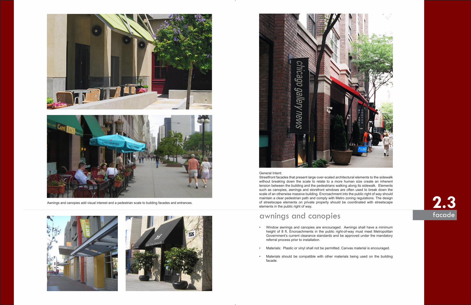
General Intent: Streetfront facades that present large over-scaled architectural elements to the sidewalk
without breaking down the scale to relate to a more human size create an inherent tension between the building and the pedestrians walking along its sidewalk. Elements such as canopies, awnings and storefront windows are often used to break down the scale of an otherwise massive building. Encroachment into the public right of way should maintain a clear pedestrian path and comply with Metro zoning regulations. The design of streetscape elements on private property should be coordinated with streetscape elements in the public right of way.
awnings and canopies• Window awnings and canopies are encouraged. Awnings shall have a minimum
height of 8 ft. Encroachments in the public right-of-way must meet Metropolitan Government’s current clearance standards and be approved under the mandatory referral process prior to installation.
• Materials: Plastic or vinyl shall not be permitted. Canvas material is encouraged.
• Materials should be compatible with other materials being used on the building facade.
facade
Awnings and canopies add visual interest and a pedestrian scale to building facades and entrances.

parking & screening
3.1 surface parking/ parking structures3.2 screening requirements
The objective of the following guidelines is to minimize the impact of parking and other unsightly elements on the pedestrian realm.

3.1
General Intent:Parking garages can diminish the aesthetic value of a city, and surface parking lots break down the sense of enclosure that is characteristic of an urban street. At the street level, parking does not engender the activity that is crucial to the safety and comfort of pedestrians. Efforts should be made to diminish the impact of parking along the boulevard. For structured parking, this may be achieved using architectural detailing or by concealing the parking underground or in the core of a building. Parking should not impede street-level activity.
surface parking/parking structures parking/screening
• Parking garages that have frontage on public streets must have an architecturally or aesthetically fi nished front facade which Parking garages that have frontage on public streets must have an architecturally or aesthetically fi nished front facade which is complementary to the surrounding buildings and designed to encourage pedestrian-scale activity. They shall have the same is complementary to the surrounding buildings and designed to encourage pedestrian-scale activity. They shall have the same integrated characteristics of any building along the street edge including building materials, height restrictions, maximum uninterrupted integrated characteristics of any building along the street edge including building materials, height restrictions, maximum uninterrupted wall plane, etc. Openings in parking structures shall not exceed 52% of the total facade area.
• Building should not have exposed parking structures at the ground fl oor level, except for Almond Street.
• Facades facing the Boulevard are allowed a maximum of three levels of exposed above-grade parking. All parking levels above this Facades facing the Boulevard are allowed a maximum of three levels of exposed above-grade parking. All parking levels above this maximum shall be wrapped with built-out usable space dedicated to non-parking uses.
• Parking structures can adjust to a lower minimum required fl oor height on all fl oors above the ground fl oor.
• Parking structures shall not enter or exit on Gateway Boulevard. Access shall be from an alley or north / south street.
Pictured above is an example of a garage entrance that is located off of the primary boulevard for access and aesthetics.

3.2
General Intent:Screening serves two purposes. First, it can conceal unsightly features such as service areas, mechanical systems, and parking lots. Second, it can maintain a sense of enclosure where gaps exist in the street wall and provide a buffer between pedestrians and vehicles. Screens may be composed of shrubs, trees, berms, and/or walls. Any plants used in screening should be chosen based on their hardiness and ability to provide a year-round visual barrier. Surface parking is strongly discouraged, as it is detrimental to a cohesive urban fabric and antithetical to the public vision expressed for the boulevard.
screening requirements
• Service elements such as loading docks and trash collection locations shall not be accessible from Gateway Boulevard. Loading areas are encouraged to be located off-street and shall be screened from view of a public street excluding alleys.
• Fences and walls attached to buildings shall be developed as architectural extensions of the building, and be constructed of the same materials and in the same style.
• Mechanical elements, whether located on the ground or rooftop, shall be screened from public view.
• Though strongly discouraged, where surface parking lots do occur fronting side streets, they shall be separated from the sidewalk by a visual screen composed of a landscaping bed and/or a masonry wall with a minimum height of 3 feet. If only a landscaping bed is used, the bed shall be a minimum of 6 feet in width, shall include regularly-spaced canopy trees, shall be irrigated, and shall be planted with a visually impervious screen of shrubs with a minimum height of 3 feet at installation.
• Though strongly discouraged, where surface parking lots do occur fronting Gateway Boulevard, they shall be separated from the sidewalk by a visual screen composed of a masonry wall with minimum height of 6 feet and featuring vertical architectural articulations occurring at minimum intervals of 10 linear feet. The wall shall be designed so as to promote visual interest along the sidewalk and, if applicable, shall wrap around any street corner a minimum distance of 20 feet along the side street. The screen shall also include an irrigated, six-foot landscaping bed fronting the sidewalk to be planted with visually impervious shrubs with a minimum height of 3 feet at installation.
parking/screeningScreening along parking lots provides visual and physical seperation for the
pedestrian