Embed Size (px)
Citation preview
GAW Report No. 188
Revision of the World Data Centre for Greenhouse Gases Data Submission and Dissemination Guide
Draft Revision of GAW 174
Preface
The World Data Centre for Greenhouse Gases (WDCGG), first established in 1990, has been operating for nearly 20 years. The amounts of observation data submitted to and information provided by the WDCGG have increased markedly with recent developments of the GAW (Global Atmosphere Watch) greenhouse gases measurement network, as well as in data processing technology and telecommunication network infrastructure, such as the Internet. Regarding these enhancements of the data exchanges, the WDCGG would like to express deep appreciation for cooperation of data submitters and users. However, under these circumstances, the data management of the WDCGG and information demands on the WDCGG have changed. Therefore, the “Data Reporting Manual of the WMO World Data Centre for Greenhouse Gases” (WDCGG No.1) published in 1991, which describes the operations of the WDCGG and data submission formats, has become unsuitable for the current operations of the Centre.
Since the United Nations Framework Convention on Climate Change (UNFCCC), which has
systematized the observation of greenhouse gases, came into force in 1994, concern regarding climate change issues has increased among not only scientists but also the general public. Furthermore, concerns regarding greenhouse and related gases have increased since the Kyoto Protocol came into force in 2005. Furthermore, the GAW Strategic Plan (2008–2015), which is in line with the Theme Report of the International Global Observing Strategy (IGOS) on Integrated Global Atmospheric Chemistry Observations, was published in May 2007.
Under the circumstances mentioned above, the WDCGG revised the Data Reporting
Manual, and newly published it as the WDCGG Data Submission and Dissemination Guide. The objectives of this Guide are as follows:
1. To make better use of Archived data, the overall activities of the WDCGG in responding to
the social demands of observers, scientific communities, and the public are introduced. 2. To collect more appropriate observation data and associated metadata, the purposes,
function, and operational courses of the WDCGG are clarified.
This guide will be updated, as required, on the WDCGG website to adapt in an appropriate manner to changing demands.
Note: All correspondence should be made in English.
Table of Contents 1. WMO/GAW PROGRAMME AND THE WDCGG ....................................................................................... 1 1.1 GAW Programme ....................................................................................................................................... 1 1.2 History and objectives of the WDCGG....................................................................................................... 1 1.3 Functions of the WDCGG........................................................................................................................... 2 2. DEFINITIONS............................................................................................................................................. 3 2.1 Station......................................................................................................................................................... 3 2.2 Contributor(s), Supporting Contributor(s), Station Manager, Contact Person and
Responsible Investigator ........................................................................................................................... 3 2.2.1 Contributor(s)..................................................................................................................................... 3 2.2.2 Supporting Contributor(s) (optional).................................................................................................. 3 2.2.3 Station Manager ................................................................................................................................ 3 2.2.4 Contact Person for station................................................................................................................. 3 2.2.5 Contact Person for measurement ..................................................................................................... 3 2.2.6 Responsible Investigator (optional)............................................................................................... 3 2.3 Observation data: measurement data and metadata................................................................................. 3 2.3.1 Measurement data ............................................................................................................................ 3 2.3.2 Metadata............................................................................................................................................ 3 2.4 Archived data.............................................................................................................................................. 4 2.5 Data flagging .............................................................................................................................................. 4 2.6 Flagging by the WDCGG............................................................................................................................ 4 3. DATA SUBMITTED TO THE WDCGG ..........................................................................................4 3.1 Parameters ................................................................................................................................................. 4 3.2 Scope of data ............................................................................................................................................. 4 3.3 Classification of observation....................................................................................................................... 5 3.4 Temporal representation ............................................................................................................................ 5 4. DATA SUBMISSION AND ACCEPTANCE............................................................................................... 5 4.1 First submission.......................................................................................................................................... 5 4.2 Data submission means .....................................................................................................5 4.3 Data file format for submission................................................................................................................... 5 4.4 Metadata..................................................................................................................................................... 6 4.5 Data validation and acceptance ................................................................................................................. 6 5. DISSEMINATION OF ARCHIVED DATA AND SUPPORTING INFORMATION...................................... 6 5.1 Dissemination of archived data and their file formats ................................................................................ 6 5.2 Data versions.............................................................................................................................................. 6 5.3 Dissemination of data supporting information ........................................................................................ 7 5.3.1 Visualized information ....................................................................................................................... 7 5.3.2 Products ............................................................................................................................................ 7 5.3.3 WDCGG publications ........................................................................................................................ 7 5.4 WDCGG website ........................................................................................................................................ 7 5.5 Data dissemination policy and credit for use.............................................................................................. 7 5.6 GAW Station Information System (GAWSIS).................................................................................... 8 6. CONTACT INFORMATION ....................................................................................................................... 8 Annex 1: Measurement Parameters in the WDCGG ..................................................................... 9 Annex 2: File Format for Data Submission ................................................................................ 12 Annex 3: File Name for Archived Data...................................................................................... 14 Annex 4: File Format for Archived Data .................................................................................... 16 Annex 5: Metadata Statement ............................................................................................................. 28 ABBREVIATION AND ACRONYMS ................................................................................................................ 40 GLOBAL ATMOSPHERE WATCH REPORT SERIES.................................................................................... 41

2
1
1. WMO/GAW PROGRAMME AND THE WDCGG 1.1 GAW Programme
During the 1970s, important atmospheric environmental issues, such as global warming due to increased levels of greenhouse gases, ozone depletion in the stratosphere caused by halocarbons and the acidification of lakes and forests due to acid rain, were addressed. This has resulted in international concerns regarding these global environmental problems, which require international coordination and cooperative activities.
With this background, the World Meteorological Organization (WMO), which has contributed
to scientific assessment through implementation of the Global Ozone Observation System (GO3OS) and the Background Pollution Monitoring Network (BAPMoN), consolidated these two monitoring programmes into the Global Atmosphere Watch (GAW) programme in 1989.
The mission of the Global Atmosphere Watch is to: • Reduce environmental risks to society and meet the requirements of environmental
conventions. • Strengthen capabilities to predict climate, weather and air quality. • Contribute to scientific assessments in support of environmental policy
through
• Maintaining and applying global, long-term observations of the chemical composition and
selected physical characteristics of the atmosphere. • Emphasizing quality assurance and quality control. • Delivering integrated products and services of relevance to users.
To support and achieve these goals, GAW has established Expert Groups i.e., Scientific Advisory Groups (SAGs) to organize and coordinate GAW activities based on parameters, and World Central Facilities, i.e., Quality Assurance/Science Activity Centres (QA/SACs) to perform network-wide data quality functions, Central Calibration Laboratories (CCLs) to host the reference standards, World Calibration Centres (WCCs) to assist GAW stations to link their observations to the GAW primary standard, and World Data Centres to archive and provide the atmospheric measurement data and associated metadata.
There are six GAW World Data Centres (WDCs) – for Greenhouse Gases, Ozone/UV,
Precipitation Chemistry, Solar Radiation, Aerosols, and Remote Sensing of the Atmosphere – which collect, archive, and provide observation data from various platforms all over the world. Furthermore, they collaborate closely with other GAW facilities, such as SAGs, QA/SACs, etc., to improve data quality, interpretation, and analysis, which play important roles in the promotion of GAW.
1.2 History and objectives of the WDCGG
The WDCGG, which is one of the WDCs under the WMO GAW programme, has been operating since October 1990 at the Japan Meteorological Agency (JMA). In October 2002, the WDCGG took over the role of the World Data Centre for Surface Ozone (WDCSO) from the Norwegian Institute for Air Research (NILU).
Furthermore, under the agreement between the Global Climate Observing System (GCOS)
and WMO/GAW that considers the WMO/GAW global atmospheric CO2 and CH4 monitoring network as a comprehensive network of GCOS, the WDCGG is charged with the data management and dissemination of value-added products on these species in order to facilitate more reliable monitoring and data analysis.
2
The objectives of the WDCGG are to assist sscientific research and assessments preparation in support of policies for environmental issues such as global warming, ultimately to contribute towards reducing societal environmental risks and to meet the requirements of related environmental conventions.
1.3 Functions of the WDCGG
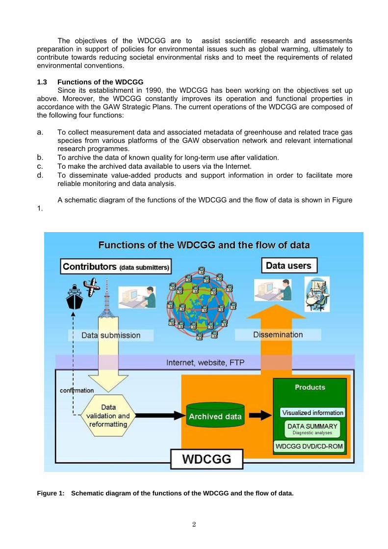
Since its establishment in 1990, the WDCGG has been working on the objectives set up above. Moreover, the WDCGG constantly improves its operation and functional properties in accordance with the GAW Strategic Plans. The current operations of the WDCGG are composed of the following four functions:
a. To collect measurement data and associated metadata of greenhouse and related trace gas
species from various platforms of the GAW observation network and relevant international research programmes.
b. To archive the data of known quality for long-term use after validation. c. To make the archived data available to users via the Internet. d. To disseminate value-added products and support information in order to facilitate more
reliable monitoring and data analysis.
A schematic diagram of the functions of the WDCGG and the flow of data is shown in Figure 1.
Figure 1: Schematic diagram of the functions of the WDCGG and the flow of data.
3
2. DEFINITIONS Fundamental concepts and terms used in this guide are defined in this section.
2.1 Station
In this guide, station is a platform at which observation is performed. The station consists of stationary platform (including tower), mobile platform (any non-stationary platform, including ship and aircraft), and platform for ice core.
2.2 Contributor(s), Supporting Contributor(s), Station Manager, Contact Person, and
Responsible Investigator The Contributor(s), Contact Person, and Responsible Investigator are designated for each
parameter. The Station Manager(s) and Contact Person for the station are designated for each station.
2.2.1 Contributor(s)
The Contributor(s) is an institute(s) or organization(s) that obtains and submits the observation data.
2.2.2 Supporting Contributor(s) (optional)
The Supporting Contributor(s) is an institute(s) or organization(s) other than the Contributor that technically or financially supports the observation.
2.2.3 Station Manager
The Station Manager is an institute or organization that organizes and manages the station or the mobile measurement cruise.
2.2.4 Contact Person for station
The Contact Person for the station is a person who reports or receives inquiries on station information such as geography and environment surrounding the station.
2.2.5 Contact Person for measurement
The Contact Person for measurement is a person who receives inquiries, requests, or consultations on the observation.
2.2.6 Responsible Investigator (optional)
The Responsible Investigator is a person who is officially or scientifically responsible for the observation.
2.3 Observation data: measurement data and metadata
The observation data consist of measurement data and metadata. 2.3.1 Measurement data
Measurement data for parameters consist of mole fractions or meteorological data and relevant data (data flag, standard deviation, the number of data used to average, etc.). In the case of mobile platforms, measurement locations (latitude and longitude, etc.) are also included in the measurement data. The measurement data must represent physical quantities and are not “raw data” (see Section 3.2). Measurement data for atmospheric constituents should use units in mole fractions such as ppm (μmol/mol), ppb (nmol/mol), and ppt (pmol/mol), instead of concentrations such as μg/m3. Other parameters should be reported in widely accepted units: ‰ for isotopic measurements, Bq/m3 for 222Rn and 85Kr, and μmol/kg or μmol/ℓ for total inorganic carbon.
2.3.2 Metadata
Metadata are additional information for observation such as observatory locations, sampling conditions, measurement methods, calibrations, traceability of employed scale, quality management information, etc. Metadata are essential to utilize measurement data. Published scientific papers are also useful for further reference. Therefore, the WDCGG requests Contributors to keep their metadata up-to-date and make the observation conditions clear to data users. If part of the
4
metadata is changed, the data version may also change (see Section 5.2). Data users should fully understand the metadata to use the data appropriately for their own purposes.
2.4 Archived data
Measurement data and metadata are stored in the WDCGG and provided to users as “Archived data”. The WDCGG prepares user supporting information based on Archived data.
2.5 Data flagging
The data flag, which is given by the Contributor, represents the quality or classification of measurement data based on observation conditions. The latter are related to instrument state or meteorological conditions, which could be critical in identifying influences of sources and sinks around the station. The data flag consists of values or characters defined by the Contributors, and each piece of measurement data must have its own data flag. The WDCGG requests Contributors to provide their flags with simple and specific definitions. Below is an example of the NOAA/ESRL/GMS flagging.
Table 1: Example of NOAA/ESRL/GMD flagging (CO2).
Flag Definition ... No code applied. Data are considered 'background' C.. Weekly calibration of reference gases, no data available I.. Instrument malfunction, no data available .V. Large variability of CO2 mixing ratio within one hour .D. Hour-to-hour difference in mixing ratio > 0.25 ppm .A. Automatic selection based on residuals from a spline curve
2.6 Flagging by the WDCGG
The WDCGG may prepare some selected datasets to meet the demands of the scientific community after consulting with the Scientific Advisory Group for Greenhouse Gases. In this case, the WDCGG will add some flags to the Archived data.
3. DATA SUBMITTED TO THE WDCGG
3.1 Parameters
The WDCGG collects measurements regarding greenhouse gases and related gases in the atmosphere and the ocean. As of 1 August 2009, the WDCGG archives measurement data for gaseous species listed in Annex 1.
3.2 Scope of data
Contributors should not report “raw data,” such as equipment voltage or direct outputs from data loggers, but physical quantities, such as mole fractions after adequate calibration and quality checks against errors from instrument malfunctions or inappropriate data processing.
The Contributor or Responsible Investigator is responsible for the quality of submitted data.
The WDCGG requests Contributors to add data flags to all measurement data and specify their in their metadata. The Standard Operating Procedures (SOPs), guidelines, and recommendations for each parameter shown in GAW reports No. 97 (ozone measurements), No. 134 (CO2 measurements), No. 171 (VOCs), and No. 185 (CH4 and N2O) should be referred to.
Temporally averaged data are useful for analyses. The WDCGG recommends that
Contributors for stationary platforms submit monthly and daily mean data, as well as hourly mean or event sample data flagged to distinguish background conditions. If averaged data are not submitted, the WDCGG will produce relevant temporal average data in consideration of the data flag aiming at facilitating data use (see Annex 4).
5
3.3 Classification of observation
Measurement data are classified into six observation categories according to the observation platforms or methods used.
1. Air observation at a stationary platform. 2. Air observation by mobile platforms (aircraft, ships, etc.). 3. Vertical profile observation of air (e.g. multi heights observation using a tower). 4. Hydrographic observation by ships. 5. Ice core observation. 6. Observation of surface seawater and overlying air.
3.4 Temporal representation
The WDCGG archives one-minute (mobile only), ten-minute, hourly, daily, and monthly mean, and event sample data. For continuous observation at a stationary platform, the WDCGG recommends submitting data averaged over a longer period than ten minutes. As for hydrographic sampling observation, the WDCGG employs the WOCE (World Ocean Circulation Experiments) exchange format (Refer to the WOCE Hydrographic Programme Office, http://woce.nodc.noaa.gov/woce_v3/wocedata_1/whp/index.htm) that is widely used in the hydrographic measurement community as the data submission format.
4. DATA SUBMISSION AND ACCEPTANCE
The WDCGG collects observation data regarding greenhouse and related gases from GAW global, regional and contributing stations, as well as from other cooperating research programmes. The WDCGG recommends Contributors to use internet-based data submission (see Section 4.2).
4.1 First submission
Contributors have to contact the WDCGG (see Section 6) to clarify the submission methods before their first submission. The WDCGG receives data on the premise that Contributors consent to the data dissemination policy and credit for use in GAW (see Section 5.5).
4.2 Data submission means
Data submission in hardcopy is no longer accepted. The means for data submission to the WDCGG are as follows:
1. Electronic mail submission (recommended)
Data in a volume of less than 1 MB should be submitted by electronic mail. 2. FTP submission
If data submission by electronic mail is difficult, data can be submitted by FTP. Contributors have to contact the WDCGG to obtain a password for access to the WDCGG FTP server before their submission.
3. Website submission (metadata only)
Contributors can submit metadata using the submission form on the WDCGG website. For website submission, Contributors need to contact the WDCGG in advance to obtain a URL for it.
4. Submission on diskette or CD-ROM
The WDCGG receives data submitted on electronic media, such as CD-ROM or diskettes (1.44 MB, Windows format).
5. Data security policy
Contributors must not make their password available to others. 4.3 Data file format for submission
Since any common submission formats for trace gases have not been established, the WDCGG has taken on the role of data conversion from different formats to the WDCGG format.
6
According to the recent dramatic increment in the amount of submitted data to the WDCGG, establishment of an efficient submission procedure is indispensable for a smooth operation of the WDCGG. As one of the effective solutions for the problem, the WDCGG proposes a submission format that would be acceptable both to the data submitters and contributors and to the WDCGG.
With regard to currently submitted data, the WDCGG continues to accept data in the current
text format. In the case of a new submission, however, the WDCGG strongly encourages the Contributors to use the formats defined by this guide. The details of the format for data submission are described in Annex 2.
4.4 Metadata
Metadata are only accepted from the WDCGG website. Contributors must submit metadata for every parameter. Metadata are indispensable for data users (see Section 2.3.2), and therefore Contributors should inform the WDCGG of adequate information according to the metadata format fully aware of their importance.
Contributors are asked to keep their metadata updated. A history of the instrumentation and
calibration methods should also be included in the metadata. In the case that corrected data are submitted to replace existing Archive data, the reasons for the corrections should be given in new metadata (e.g. changes in the scale employed, or corrections of standard gas drift, etc.). The details of the metadata format are described in Annex 5.
4.5 Data validation and acceptance
When data are submitted, the WDCGG validates the data and inquires about questionable data to clarify the reasons if necessary. In some cases, the WDCGG may consult with the Scientific Advisory Group for Greenhouse Gases or QA/SAC. After the confirmation via these procedures, the WDCGG accepts the submitted data.
When the data are accepted, a receipt is sent to the Contributor by electronic mail, facsimile,
or postal mail. At the same time, the WDCGG asks the Contributors to check the data if they include inappropriate data for the Contributors before storing them as Archived data.
5. DISSEMINATION OF ARCHIVED DATA AND SUPPORTING INFORMATION
The WDCGG prepares supporting information, such as visualized information and products, as well as Archived data. This chapter describes methods of distribution and the contents of supporting information.
5.1 Dissemination of archived data and their file formats
The WDCGG uploads Archived data on the WDCGG website in dissemination file formats, and make them available to users.
After publishing the DATA REPORTING MANUAL in 1991, data submitted to the WDCGG
became much diversified in species and types (e.g. mobiles and towers), which proliferated file formats of Archived data. As a result, complicated handling of data files using computer degraded the usability of data in the WDCGG. To overcome the circumstance, the WDCGG has established new file formats for data dissemination aiming at the facilitation of use of Archived data in the WDCGG.
The measurement data are disseminated as data files. The metadata are viewed on the
WDCGG website. The details of the dissemination file format of measurement data are described in Annex 4. The files of measurement data can also be downloaded from the FTP site in the WDCGG.
5.2 Data versions
The version of the Archived data is presented in their header part, and a new version is assigned when existing data are replaced by new data that have different quality. Older versions of Archived data are also available in addition to the latest Archived data in the WDCGG.
7
5.3 Dissemination of supporting information
5.3.1 Visualized information
The WDCGG provides visualized information, such as quick plots of time series of measurement data and location maps of observation stations, to overview archived data or to facilitate search of target data. They can be utilized and viewed on the WDCGG website. Please note that the information is not for scientific purposes but for data users’ convenience.
5.3.2 Products
The WDCGG summarizes the current status and changes in global concentrations of greenhouse gases based on the Archived data. These products by the WDCGG are as follows:
a. Fundamental status for greenhouse gases (global mean and hemispheric mean, etc.). b. Chart of data sequences of all stations colored in accordance with monthly averaged mole fractions. c. Visualization of data analyses, such as three-dimensional representations.
The results and analytical methods are included in the WDCGG DATA SUMMARY, which is
available on the WDCGG website. The details of the data processing are presented in the Technical Report of Global Analysis Method for Major Greenhouse Gases by the World Data Center for Greenhouse Gases (GAW report No. 184, available at http://www.wmo.int/gaw/)
5.3.3 WDCGG publications
The WDCGG publishes the “WMO WDCGG DATA SUMMARY” and “WMO WDCGG DVD (previously CD-ROM)” every year. The contents of these publications are as follows:
a. WMO WDCGG Data Summary
The DATA SUMMARY includes the latest results of the diagnostic analysis described in Section 5.3.2 as well as location maps of observation stations, a list of observation stations, and a list of Station Managers to provide intelligible information concerning greenhouse gases.
b. WMO WDCGG DVD
The DVD (previously CD-ROM) includes Archived data and relevant metadata on Station organizers, stations, measurement methods, and calibration techniques employed. Visualized information such as station location maps, cruise maps, and time series graphs of measurement data are also available.
The WDCGG distributes these products containing Archived data and analytical products to
Contributors, National Meteorological and Hydrological Services (NMHSs), and GAW related organizations in collaboration with the WMO. These publications are also available on the WDCGG website.
5.4 WDCGG website
The WDCGG website (http://gaw.kishou.go.jp/wdcgg/) provides the latest and older versions of Archived data, supporting information, and the WDCGG publications. The Archived data can also be downloaded from the FTP site of the WDCGG. Data users can use these data freely on the condition that due credit is given as described in Section 5.5, but for non-profit purposes only.
The contents and design of the website can be revised as necessary and without notification.
The WDCGG Data Submission and Dissemination Guide will be updated as required to adapt in an appropriate manner to changing demands. The latest version of this guide can be obtained on the WDCGG and GAW websites.
5.5 Data dissemination policy and credit for use
All users are requested to accept the following conditions set forth by the Commission for Atmospheric Sciences (CAS) Working Group and supported by the Thirteenth Session of CAS: "For scientific purposes, access to these data is unlimited and provided without charge. By their
8
use you accept that an offer of co-authorship will be made through personal contact with the data providers or owners whenever substantial use is made of their data. In all cases, an acknowledgement must be made to the data providers or owners and to the data centre when these data are used within a publication."
When analytical outputs or information are taken from publications of the WDCGG, the
source must be properly acknowledged. User cooperation is essential to maintain and develop the operations of the GAW observation network and facilities.
The WDCGG may restrict data use in case users do not adhere to the WDCGG data
dissemination policy after consultation with the Secretariat of the WMO/GAW. 5.6 GAW Station Information System (GAWSIS)
GAWSIS is being developed and maintained by QA/SAC Switzerland in collaboration with the WMO GAW Secretariat, GAW World Data Centres, and other GAW representatives to improve the management of information about the GAW network of ground-based stations. The GAWSIS database (http://gaw.empa.ch/gawsis/) provides up-to-date information on sites description, measurements programmes, contact persons, and the link to the World Data Center where the respective data are available.
6. CONTACT INFORMATION
WMO World Data Centre for Greenhouse Gases (WDCGG) Japan Meteorological Agency 1-3-4, Otemachi, Chiyoda-ku, Tokyo, 100-8122 JAPAN Tel: +81-3-3287-3439 Fax:+81-3-3211-4640 E-mail: [email protected] URL: http://gaw.kishou.go.jp/wdcgg/
****
9
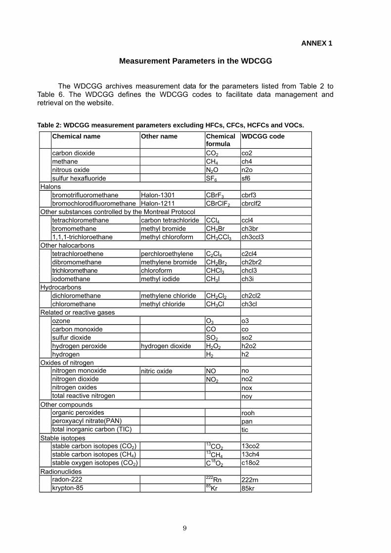
ANNEX 1
Measurement Parameters in the WDCGG
The WDCGG archives measurement data for the parameters listed from Table 2 to Table 6. The WDCGG defines the WDCGG codes to facilitate data management and retrieval on the website.
Table 2: WDCGG measurement parameters excluding HFCs, CFCs, HCFCs and VOCs.
Chemical name Other name Chemical formula
WDCGG code
carbon dioxide CO2 co2methane CH4 ch4nitrous oxide N2O n2o
sulfur hexafluoride SF6 sf6Halons
bromotrifluoromethane Halon-1301 CBrF3 cbrf3 bromochlorodifluoromethane Halon-1211 CBrClF2 cbrclf2
Other substances controlled by the Montreal Protocoltetrachloromethane carbon tetrachloride CCl4 ccl4bromomethane methyl bromide CH3Br ch3br
1,1,1-trichloroethane methyl chloroform CH3CCl3 ch3ccl3Other halocarbons
tetrachloroethene perchloroethylene C2Cl4 c2cl4dibromomethane methylene bromide CH2Br2 ch2br2trichloromethane chloroform CHCl3 chcl3
iodomethane methyl iodide CH3I ch3iHydrocarbons
dichloromethane methylene chloride CH2Cl2 ch2cl2 chloromethane methyl chloride CH3Cl ch3cl
Related or reactive gasesozone O3 o3carbon monoxide CO cosulfur dioxide SO2 so2hydrogen peroxide hydrogen dioxide H2O2 h2o2
hydrogen H2 h2Oxides of nitrogen
nitrogen monoxide nitric oxide NO no nitrogen dioxide NO2 no2 nitrogen oxides nox
total reactive nitrogen noyOther compounds
organic peroxides roohperoxyacyl nitrate(PAN) pan
total inorganic carbon (TIC) ticStable isotopes
stable carbon isotopes (CO2) 13CO2 13co2 stable carbon isotopes (CH4) 13CH4 13ch4
stable oxygen isotopes (CO2) C18O2 c18o2 Radionuclides
radon-222 222Rn 222rn krypton-85 85Kr 85kr
10
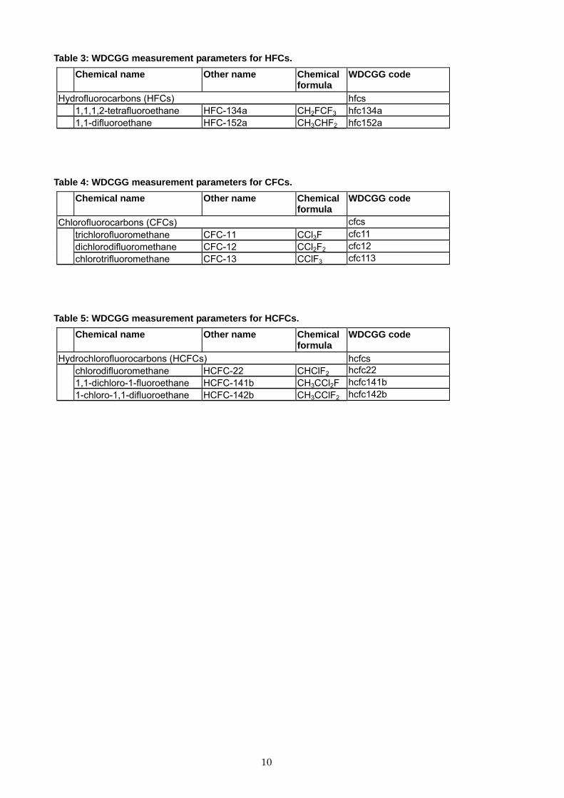
Table 3: WDCGG measurement parameters for HFCs.
Chemical name Other name Chemical formula
WDCGG code
Hydrofluorocarbons (HFCs) hfcs 1,1,1,2-tetrafluoroethane HFC-134a CH2FCF3 hfc134a 1,1-difluoroethane HFC-152a CH3CHF2 hfc152a
Table 4: WDCGG measurement parameters for CFCs.
Chemical name Other name Chemical formula
WDCGG code
Chlorofluorocarbons (CFCs) cfcs trichlorofluoromethane CFC-11 CCl3F cfc11 dichlorodifluoromethane CFC-12 CCl2F2 cfc12
chlorotrifluoromethane CFC-13 CClF3 cfc113
Table 5: WDCGG measurement parameters for HCFCs.
Chemical name Other name Chemical formula
WDCGG code
Hydrochlorofluorocarbons (HCFCs) hcfcschlorodifluoromethane HCFC-22 CHClF2 hcfc22 1,1-dichloro-1-fluoroethane HCFC-141b CH3CCl2F hcfc141b
1-chloro-1,1-difluoroethane HCFC-142b CH3CClF2 hcfc142b
11
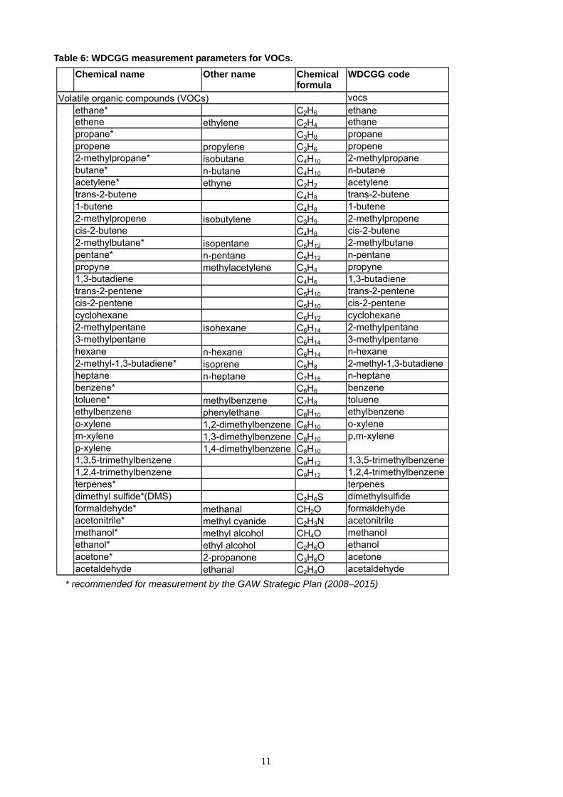
Table 6: WDCGG measurement parameters for VOCs.
Chemical name Other name Chemical formula
WDCGG code
Volatile organic compounds (VOCs) vocs ethane* C2H6 ethaneethene ethylene C2H4 ethane propane* C3H8 propane propene propylene C3H6 propene 2-methylpropane* isobutane C4H10 2-methylpropane butane* n-butane C4H10 n-butane acetylene* ethyne C2H2 acetylene trans-2-butene C4H8 trans-2-butene 1-butene C4H8 1-butene 2-methylpropene isobutylene C3H9 2-methylpropene cis-2-butene C4H8 cis-2-butene 2-methylbutane* isopentane C5H12 2-methylbutane pentane* n-pentane C5H12 n-pentane propyne methylacetylene C3H4 propyne 1,3-butadiene C4H6 1,3-butadiene trans-2-pentene C5H10 trans-2-pentene cis-2-pentene C5H10 cis-2-pentene cyclohexane C6H12 cyclohexane 2-methylpentane isohexane C6H14 2-methylpentane 3-methylpentane C6H14 3-methylpentane hexane n-hexane C6H14 n-hexane 2-methyl-1,3-butadiene* isoprene C5H8 2-methyl-1,3-butadiene heptane n-heptane C7H16 n-heptane benzene* C6H6 benzene toluene* methylbenzene C7H8 toluene ethylbenzene phenylethane C8H10 ethylbenzene o-xylene 1,2-dimethylbenzene C8H10 o-xylene m-xylene 1,3-dimethylbenzene C8H10p-xylene 1,4-dimethylbenzene C8H10
p,m-xylene
1,3,5-trimethylbenzene C9H12 1,3,5-trimethylbenzene 1,2,4-trimethylbenzene C9H12 1,2,4-trimethylbenzene terpenes* terpenes dimethyl sulfide*(DMS) C2H6S dimethylsulfide formaldehyde* methanal CH2O formaldehyde acetonitrile* methyl cyanide C2H3N acetonitrile methanol* methyl alcohol CH4O methanol ethanol* ethyl alcohol C2H6O ethanol acetone* 2-propanone C3H6O acetone
acetaldehyde ethanal C2H4O acetaldehyde * recommended for measurement by the GAW Strategic Plan (2008–2015)
12
ANNEX 2
File Format for Data Submission
The WDCGG accepts one-minute (mobile only), ten-minute, hourly, daily, and monthly mean, and event sample data for the parameters listed in Tables 2–6 in accordance with the GAW Strategic Plans.
As for hydrographic data, the WDCGG accepts only the WOCE (World Ocean Circulation
Experiments) exchange format (Refer to the WOCE Hydrographic Programme Office (WHPO), http://woce.nodc.noaa.gov/woce_v3/wocedata_1/whp/index.htm) that is widely used in the hydrographic measurement community as the submission data format.
Data File Formats
The WDCGG encourages Contributors to submit data files that meet the following points except for hydrographic observations by ships (see Section 3.3). The file format consists of a header part and a data part. Details of the file format are as follows:
1) The data file employs an ASCII format. The WDCGG does NOT accept any files in binary
formats including MS-Excel or MS-Word, which could include computer viruses, because of its computer security policy.
2) The header part includes the following 7 items that are necessary to identify the submitted data: CONTRIBUTOR, STATION NAME, PARAMETER, DATA TIME INTERVAL, MEASUREMENT UNIT, MEASUREMENT METHOD, AND STANDARD SCALE. (The definition of these items is shown in Annex 4)
3) The data part is in a delimiter (such as a space, comma, or tab)-separated format. 4) The data part should, at least, include the date, time, mole fractions, and data flag. For
averaged data, the number of data used to average and the standard deviation are also required. An averaged value and its standard deviation should be derived from the nearest shorter level of the averages, i.e., a monthly mean is derived from daily means, a daily mean from hourly means, and an hourly mean from minutely means. The definition and the meaning of flag should be submitted as metadata (see Data flag in Section 2.5 and Annex 5).
5) Each data column should be defined according to Tables 7 and 8 in the first line of the data part (i.e., the first line of the data part must be the item names of each data column).
6) DATE is represented in YYYY-MM-DD where YYYY, MM, and DD are year, month, and day respectively. The date for monthly data is represented as the first date of the month; February 2005 is represented as 2005-02-01, for example. DATE points to the beginning of the measurement or average. In the case of irregular measurements (e.g. event sampling), the end date of the measurement is also required. The WDCGG requires the Contributors to employ time representation compliant to ISO 8601.
7) TIME is represented in hh:mm where hh is hour and mm is minute. In the case of a stationary platform, TIME should be local time, and the time difference between local time and universal time is indicated in Time zone in metadata. The 24-hour clock is used. The representation of time for monthly or daily data is 00:00. TIME points to the beginning of the measurement or average. In the case of irregular measurements (e.g. event sampling), the end time of the measurement is also required.
8) In the case that valid values are not obtained, the data part should be filled with non-space numbers, characters, or combination thereof, such as “-999” and “NA”, to denote that no valid values are reported for the field. The field must NOT be left blank.
The format of the header part and the order of the data columns are arbitrary. Meteorological
data can be included in the data part or reported separately. Refer to Sample 1 as an example.
13
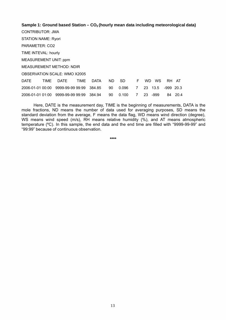
Sample 1: Ground based Station – CO2 (hourly mean data including meteorological data)
CONTRIBUTOR: JMA
STATION NAME: Ryori
PARAMETER: CO2
TIME INTEVAL: hourly
MEASUREMENT UNIT: ppm
MEASUREMENT METHOD: NDIR
OBSERVATION SCALE: WMO X2005
DATE TIME DATE TIME DATA ND SD F WD WS RH AT 2006-01-01 00:00 9999-99-99 99:99 384.85 90 0.096 7 23 13.5 -999 20.3 2006-01-01 01:00 9999-99-99 99:99 384.94 90 0.100 7 23 -999 84 20.4
Here, DATE is the measurement day, TIME is the beginning of measurements, DATA is the
mole fractions, ND means the number of data used for averaging purposes, SD means the standard deviation from the average, F means the data flag, WD means wind direction (degree), WS means wind speed (m/s), RH means relative humidity (%), and AT means atmospheric temperature (ºC). In this sample, the end data and the end time are filled with “9999-99-99” and “99:99” because of continuous observation.
****
14
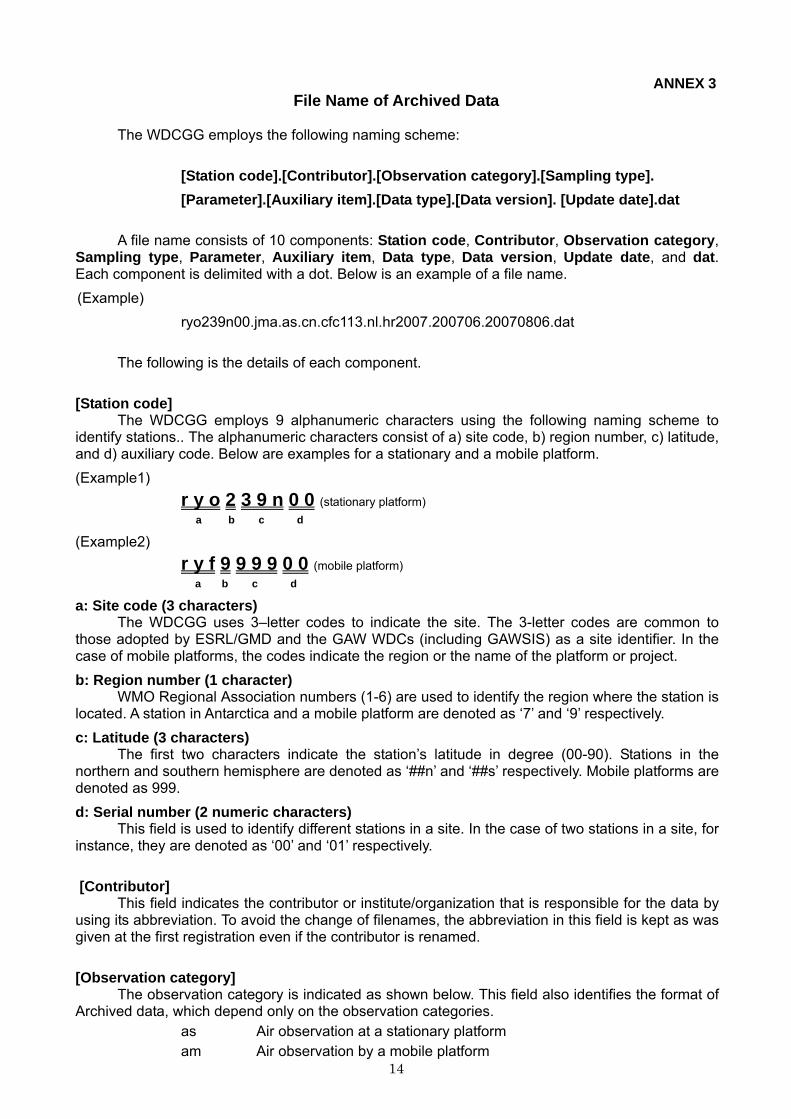
ANNEX 3 File Name of Archived Data
The WDCGG employs the following naming scheme:
[Station code].[Contributor].[Observation category].[Sampling type]. [Parameter].[Auxiliary item].[Data type].[Data version]. [Update date].dat
A file name consists of 10 components: Station code, Contributor, Observation category,
Sampling type, Parameter, Auxiliary item, Data type, Data version, Update date, and dat. Each component is delimited with a dot. Below is an example of a file name. (Example)
ryo239n00.jma.as.cn.cfc113.nl.hr2007.200706.20070806.dat
The following is the details of each component. [Station code]
The WDCGG employs 9 alphanumeric characters using the following naming scheme to identify stations.. The alphanumeric characters consist of a) site code, b) region number, c) latitude, and d) auxiliary code. Below are examples for a stationary and a mobile platform. (Example1)
r y o 2 3 9 n 0 0 (stationary platform) a b c d
(Example2) r y f 9 9 9 9 0 0 (mobile platform) a b c d
a: Site code (3 characters) The WDCGG uses 3–letter codes to indicate the site. The 3-letter codes are common to
those adopted by ESRL/GMD and the GAW WDCs (including GAWSIS) as a site identifier. In the case of mobile platforms, the codes indicate the region or the name of the platform or project. b: Region number (1 character)
WMO Regional Association numbers (1-6) are used to identify the region where the station is located. A station in Antarctica and a mobile platform are denoted as ‘7’ and ‘9’ respectively. c: Latitude (3 characters)
The first two characters indicate the station’s latitude in degree (00-90). Stations in the northern and southern hemisphere are denoted as ‘##n’ and ‘##s’ respectively. Mobile platforms are denoted as 999. d: Serial number (2 numeric characters)
This field is used to identify different stations in a site. In the case of two stations in a site, for instance, they are denoted as ‘00’ and ‘01’ respectively.
[Contributor]
This field indicates the contributor or institute/organization that is responsible for the data by using its abbreviation. To avoid the change of filenames, the abbreviation in this field is kept as was given at the first registration even if the contributor is renamed.
[Observation category]
The observation category is indicated as shown below. This field also identifies the format of Archived data, which depend only on the observation categories.
as Air observation at a stationary platform am Air observation by a mobile platform
15
ap Vertical profile observation of air tc Total column observation at a stationary platform hy Hydrographic observation by ships ic Ice core observation sf Observation of surface seawater and overlying air (“xx” is used for meteorologocal data.)
[Sampling type]
This field indicates the sampling type for obtaining the data. cn Continuous or quasi-continuous in situ measurement fl Analysis of air samples in flasks fi Filter measurement rs Remote sensing ic Analysis of ice core samples bo Analysis of samples in bottles ot Other (“xx” is used for meteorologocal data.)
[Parameter]
This field identifies the species expressed as parameter codes in Tables 2–6. (Example)
co2 Carbon dioxide cfc11 Chlorofluorocarbon-11 hcfc141b Hydrochlorofluorocarbon-141b hfc134a Hydrofluorocarbon-134a ethane Ethane met Meteorology (wind direction, wind speed, etc.)
[Data type]
This field indicates the data type categorized as listed below. In the case of hourly mean data, the year of the data follows ‘hr’.
ev Event sampling data om One-minute mean data tm Ten-minute mean data hrxxxx Hourly mean data observed in the year xxxx da Daily mean data mo Monthly mean data
[Auxiliary item]
If a data file is NOT identified uniquely with the codes above, this field is filled with some characters to give a unique filename. Most files have ‘nl’ in this field, which means ‘NULL’.
[Data version (YYYYMM)]
To specify the data version, this field indicates the date when the data were replaced with newly recalculated data. This field is used only for old archived data files in “ftp://gawdb.env.naps. kishou.go.jp/pub/data/previous/”.
[Update date (YYYYMMDD)]
This field indicates the date when the data file was updated. This field is used only for old archived data files in “ftp://gawdb.env.naps.kishou.go.jp/pub/data/previous/”.
16
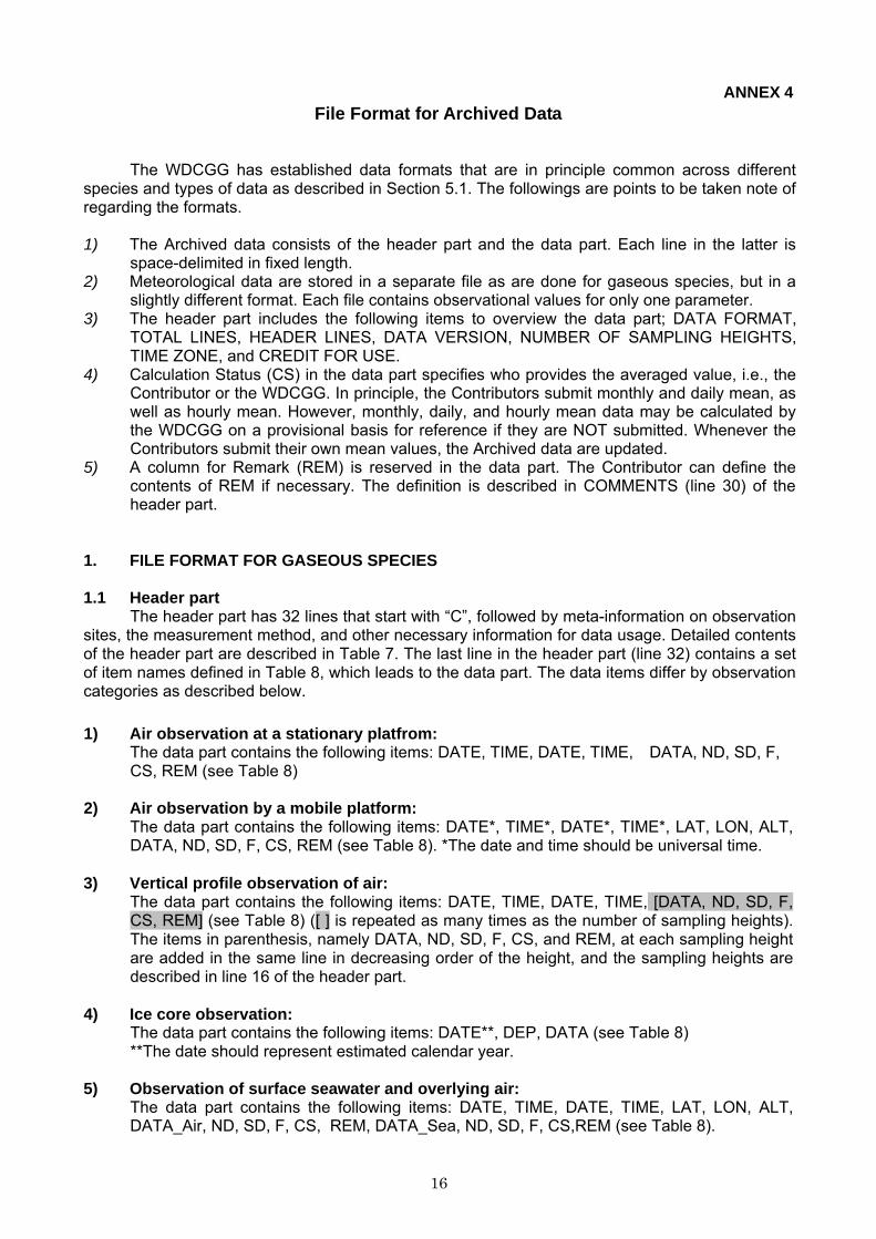
ANNEX 4 File Format for Archived Data
The WDCGG has established data formats that are in principle common across different species and types of data as described in Section 5.1. The followings are points to be taken note of regarding the formats.
1) The Archived data consists of the header part and the data part. Each line in the latter is
space-delimited in fixed length. 2) Meteorological data are stored in a separate file as are done for gaseous species, but in a
slightly different format. Each file contains observational values for only one parameter. 3) The header part includes the following items to overview the data part; DATA FORMAT,
TOTAL LINES, HEADER LINES, DATA VERSION, NUMBER OF SAMPLING HEIGHTS, TIME ZONE, and CREDIT FOR USE.
4) Calculation Status (CS) in the data part specifies who provides the averaged value, i.e., the Contributor or the WDCGG. In principle, the Contributors submit monthly and daily mean, as well as hourly mean. However, monthly, daily, and hourly mean data may be calculated by the WDCGG on a provisional basis for reference if they are NOT submitted. Whenever the Contributors submit their own mean values, the Archived data are updated.
5) A column for Remark (REM) is reserved in the data part. The Contributor can define the contents of REM if necessary. The definition is described in COMMENTS (line 30) of the header part.
1. FILE FORMAT FOR GASEOUS SPECIES
1.1 Header part
The header part has 32 lines that start with “C”, followed by meta-information on observation sites, the measurement method, and other necessary information for data usage. Detailed contents of the header part are described in Table 7. The last line in the header part (line 32) contains a set of item names defined in Table 8, which leads to the data part. The data items differ by observation categories as described below.
1) Air observation at a stationary platfrom:
The data part contains the following items: DATE, TIME, DATE, TIME, DATA, ND, SD, F, CS, REM (see Table 8)
2) Air observation by a mobile platform:
The data part contains the following items: DATE*, TIME*, DATE*, TIME*, LAT, LON, ALT, DATA, ND, SD, F, CS, REM (see Table 8). *The date and time should be universal time.
3) Vertical profile observation of air:
The data part contains the following items: DATE, TIME, DATE, TIME, [DATA, ND, SD, F, CS, REM] (see Table 8) ([ ] is repeated as many times as the number of sampling heights). The items in parenthesis, namely DATA, ND, SD, F, CS, and REM, at each sampling height are added in the same line in decreasing order of the height, and the sampling heights are described in line 16 of the header part.
4) Ice core observation:
The data part contains the following items: DATE**, DEP, DATA (see Table 8) **The date should represent estimated calendar year.
5) Observation of surface seawater and overlying air:
The data part contains the following items: DATE, TIME, DATE, TIME, LAT, LON, ALT, DATA_Air, ND, SD, F, CS, REM, DATA_Sea, ND, SD, F, CS,REM (see Table 8).
17
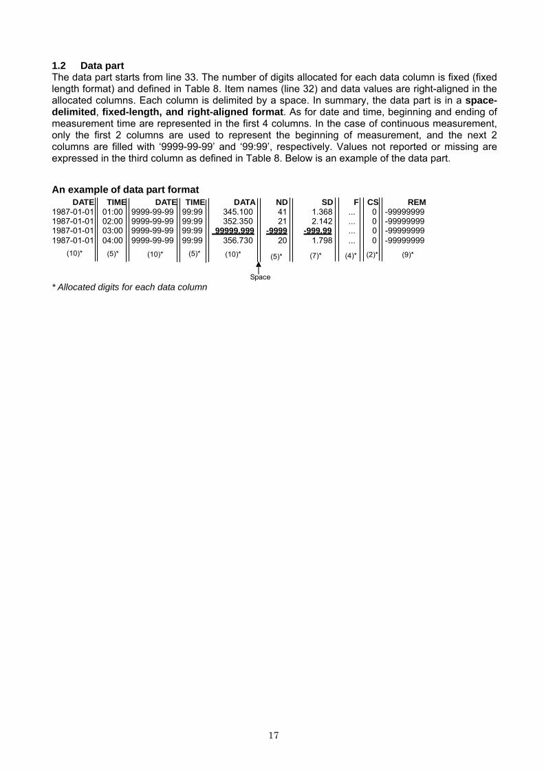
1.2 Data part The data part starts from line 33. The number of digits allocated for each data column is fixed (fixed length format) and defined in Table 8. Item names (line 32) and data values are right-aligned in the allocated columns. Each column is delimited by a space. In summary, the data part is in a space-delimited, fixed-length, and right-aligned format. As for date and time, beginning and ending of measurement time are represented in the first 4 columns. In the case of continuous measurement, only the first 2 columns are used to represent the beginning of measurement, and the next 2 columns are filled with ‘9999-99-99’ and ‘99:99’, respectively. Values not reported or missing are expressed in the third column as defined in Table 8. Below is an example of the data part.
An example of data part format
DATE TIME DATE TIME DATA ND SD F CS REM 1987-01-01 01:00 9999-99-99 99:99 345.100 41 1.368 ... 0 -99999999 1987-01-01 02:00 9999-99-99 99:99 352.350 21 2.142 ... 0 -99999999 1987-01-01 03:00 9999-99-99 99:99 99999.999 -9999 -999.99 ... 0 -99999999 1987-01-01 04:00 9999-99-99 99:99 356.730 20 1.798 ... 0 -99999999
(10)* (5)* (10)*
(5)* (10)*
(5)*
(7)*
(4)*
(2)* (9)*
* Allocated digits for each data column Space
18
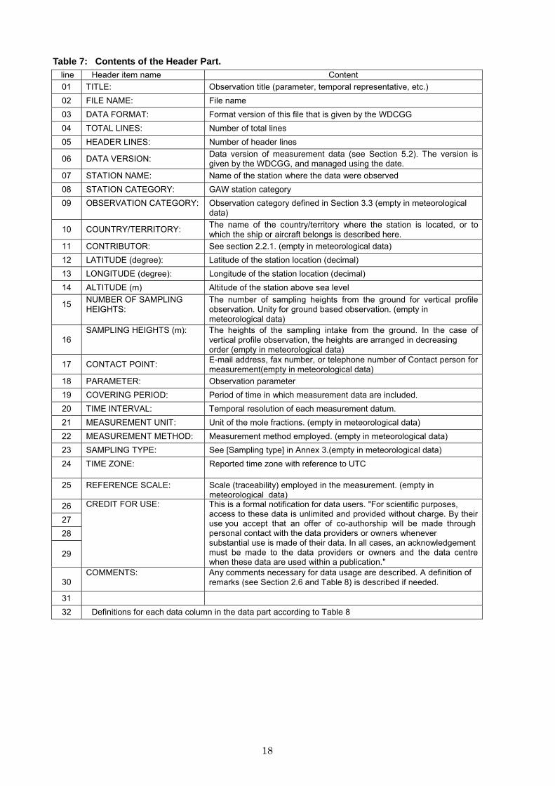
Table 7: Contents of the Header Part.
line Header item name Content 01 TITLE: Observation title (parameter, temporal representative, etc.) 02 FILE NAME: File name 03 DATA FORMAT: Format version of this file that is given by the WDCGG 04 TOTAL LINES: Number of total lines 05 HEADER LINES: Number of header lines
06
DATA VERSION: Data version of measurement data (see Section 5.2). The version is given by the WDCGG, and managed using the date.
07 STATION NAME: Name of the station where the data were observed 08 STATION CATEGORY: GAW station category 09 OBSERVATION CATEGORY: Observation category defined in Section 3.3 (empty in meteorological
data)
10
COUNTRY/TERRITORY: The name of the country/territory where the station is located, or to which the ship or aircraft belongs is described here.
11 CONTRIBUTOR: See section 2.2.1. (empty in meteorological data) 12 LATITUDE (degree): Latitude of the station location (decimal) 13 LONGITUDE (degree): Longitude of the station location (decimal) 14 ALTITUDE (m) Altitude of the station above sea level
15 NUMBER OF SAMPLING HEIGHTS:
The number of sampling heights from the ground for vertical profile observation. Unity for ground based observation. (empty in meteorological data)
16
SAMPLING HEIGHTS (m): The heights of the sampling intake from the ground. In the case of vertical profile observation, the heights are arranged in decreasing order (empty in meteorological data)
17
CONTACT POINT: E-mail address, fax number, or telephone number of Contact person for measurement(empty in meteorological data)
18 PARAMETER: Observation parameter 19 COVERING PERIOD: Period of time in which measurement data are included. 20 TIME INTERVAL: Temporal resolution of each measurement datum. 21 MEASUREMENT UNIT: Unit of the mole fractions. (empty in meteorological data) 22 MEASUREMENT METHOD: Measurement method employed. (empty in meteorological data) 23 SAMPLING TYPE: See [Sampling type] in Annex 3.(empty in meteorological data) 24 TIME ZONE: Reported time zone with reference to UTC
25 REFERENCE SCALE: Scale (traceability) employed in the measurement. (empty in meteorological data)
26 27 28
29
CREDIT FOR USE: This is a formal notification for data users. "For scientific purposes, access to these data is unlimited and provided without charge. By their use you accept that an offer of co-authorship will be made through personal contact with the data providers or owners whenever substantial use is made of their data. In all cases, an acknowledgement must be made to the data providers or owners and the data centre when these data are used within a publication."
30
COMMENTS: Any comments necessary for data usage are described. A definition of remarks (see Section 2.6 and Table 8) is described if needed.
31 32 Definitions for each data column in the data part according to Table 8
19
Table 8: List of Data Items and their Format.
Item name
Number of digits
"No Data" Content Supplementary explanation
DATE 10 9999-99-99 Beginning date of measurement (YYYY-MM-DD)
7 digits are used only for ice core to represent estimated year. The date for a monthly mean is the first date of the month. For example, 2005-02-01 is used for the monthly mean in February 2005.
TIME 5 99:99 Beginning time of measurement (hh:mm)
The time for a monthly or daily mean is represented as 00:00.
DATE 10 9999-99-99 End date of measurement (YYYY-MM-DD)
In the case of a continuous observation, end date is filled with‘9999-99-99’.
TIME 5 99:99 End time of measurement (hh:mm) In the case of a continuous observation, end time is filled with‘99:99’.
LAT 7 -99.999 Latitude of sampling location in decimal degrees with North positiveand South negative
Used only for mobile data
LON 8 -999.999 Longitude of sampling location in decimal degrees with East positiveand West negative
Used only for mobile data
ALT 7 -9999.9 Sampling height/depth (m) above/below sea level with height positive and depth negative
Used only for mobile data
DEP 7 -999999 Sampling depth of Ice core (m) Used only for ice core data DATA 10
(16) -99999.999 Mole fractions 16 digits are used only for VOCs
ND 5 -9999 Number of data used to average thedata
SD 7 -999.99 Standard deviation F 5 -9999 Data flag The details of data flags should be
specified by the Contributor in the metadata.
CS 2 -9 Calculation Status indicating who provides the data. “0” means the Contributor. “1” means the WDCGG.
This value is added by the WDCGG.
REM 9 -99999999 Data remarks Additional information on data to be included. The definition is described under “COMMENTS” of the header part.
20
2. FILE FORMAT FOR METEOROLOGICAL MEASUREMENTS In the case that the Contributor submits meteorological data in addition to gas measurement
data, the former are provided in a separate file. The meteorological data file also consists of the header part and the space-delimited data part in an ASCII format.
The header part is the same as the file for gaseous species. The last line in the header part
(line 32) defines data columns in the data part using the item names in Table 9. The number of digits allocated for each data item is fixed (fixed length format), and each item name is right-aligned in the allocated column (see Table 9, except for item name ”REM”). A space is inserted between data items as a delimiter. Refer to the examples. Table 9: Meteorological Data.
Item name
Number of digits
"No Data"
Content
Supplementary explanation DATE 10 9999-99-99 Measurement date (YYYY-MM-DD)
TIME 5 99:99 Measurement time (hh:mm)
LAT 7 -99.999 Latitude of sampling location in decimaldegrees with North positive and South negative
used only for mobile data
LON 8 -999.999 Longitude of sampling location in decimal degrees with East positive and West negative
used only for mobile data
ALT 7 -9999.9 Sampling height/depth (m) above/below sea level with height positive and depthnegative
used only for mobile data
WD
5
-99.9
Wind direction (degree)*
WS
5
-99.9
Wind speed (m/s)
WF
5
-9999
Wind steadiness factor
RH
5
-99.9
Relative humidity (%)
AP
6
-999.9
Air pressure (hPa)
AT
5
-99.9
Air temperature (degree Celsius)
DT
5
-99.9
Dew point temperature (degree Celsius)
ST
5
-99.9
Sea water temperature (degree Celsius)
SST
5
-99.9 Sea surface water temperature (degree
Celsius)
SS
7
-9999.9
Sea water salinity (psu, ‰)
SSS
7
-9999.9
Sea surface water salinity (psu, ‰)
RR
5
-99.9
Precipitation amount (mm)
REM
60
-
Data remarks Parameters of mole fraction
data that is origin of meteorological data. Used only for event data. Left-aligned.
* WD is the angle in degrees between true north and the wind direction, and increases in a clockwise direction.
21
Example1) Air observation at a stationary platform C01 TITLE: CO2 monthly mean data C02 FILE NAME: ryo239n00.jma.as.cn.co2.nl.mo.dat C03 DATA FORMAT: Version 1.0 C04 TOTAL LINES: 280 C05 HEADER LINES: 32 C06 DATA VERSION: 200711 C07 STATION NAME: Ryori C08 STATION CATEGORY: Regional C09 OBSERVATION CATEGORY: Air sampling observation at a stationary platform C10 COUNTRY/TERITORY: JAPAN C11 CONTRIBUTOR: JMA C12 LATITUDE: 39.03 C13 LONGITUDE: 141.82 C14 ALTITUDE: 260 C15 NUMBER OF SAMPLING HEIGHTS: 1 C16 SAMPLING HEIGHTS: 20 C17 CONTACT POINT: [email protected] C18 PARAMETER: CO2 C19 COVERING PERIOD: 1987-01-01 2007-08-01 C20 TIME INTERVAL: monthly C21 MEASUREMENT UNIT: ppm C22 MEASUREMENT METHOD: NDIR C23 SAMPLING TYPE: continuous C24 TIME ZONE: LOCAL TIME UTC+9 C25 MEASUREMENT SCALE: WMO X2005 scale C26 CREDIT FOR USE: This is a formal notification for data users. "For scientific purposes, access to these data is unlimited C27 and provided without charge. By their use you accept that an offer of co-authorship will be made through personal contact C28 with the data providers or owners whenever substantial use is made of their data. In all cases, an acknowledgement C29 must be made to the data providers or owners and the data centre when these data are used within a publication." C30 COMMENT: C31 C32 DATE TIME DATE TIME CO2 ND SD F CS REM 1987-01-01 00:00 9999-99-99 99:99 352.950 227 0.96 3 0 -99999999 1987-02-01 00:00 9999-99-99 99:99 353.810 265 1.03 3 0 -99999999
22
1991-06-24 00:05 9999-99-99 99:99 -38.917 145.150 4270.0 353.680 -9999 -999.99 ... 0 G050_6_C31991-06-24 00:05 9999-99-99 99:99 -38.933 145.150 4270.0 353.680 -9999 -999.99 ... 0 G050_6_C3
Example2) Air observation by a mobile platform C01 TITLE: CO2 event sampling data C02 FILE NAME: aia999900.csiro.am.fl.co2.nl.ev.dat C03 DATA FORMAT: Version 1.0 C04 TOTAL LINES: 1966 C05 HEADER LINES: 32 C06 DATA VERSION: 200709 C07 STATION NAME: Aircraft (over Bass Strait and Cape Grim) C08 STATION CATEGORY: C09 OBSERVATION CATEGORY: Air sampling observation by a mobile platform C10 COUNTRY/TERITORY: AUSTRALIA C11 CONTRIBUTOR: CSIRO C12 LATITUDE: 0 C13 LONGITUDE: 0 C14 ALTITUDE: C15 NUMBER OF SAMPLING HEIGHTS: 1 C16 SAMPLING HEIGHTS: C17 CONTACT POINT: [email protected] [email protected] C18 PARAMETER: CO2 C19 COVERING PERIOD: 1991-06-24 2000-09-28 C20 TIME INTERVAL: event C21 MEASUREMENT UNIT: ppm C22 MEASUREMENT METHOD: Gas Chromatography (FID) C23 SAMPLING TYPE: flask C24 TIME ZONE: UTC C25 MEASUREMENT SCALE: WMO mole fraction scale C26 CREDIT FOR USE: This is a formal notification for data users. "For scientific purposes, access to these data is unlimited C27 and provided without charge. By their use you accept that an offer of co-authorship will be made through personal contact C28 with the data providers or owners whenever substantial use is made of their data. In all cases, an acknowledgement C29 must be made to the data providers or owners and the data centre when these data are used within a publication." C30 COMMENT:Remark : xxxx c ii ( xxxx : flask code, c : sampling collection method code, ii : analytical instrument code ) C31 C32 DATE TIME D ATE TIME LAT LON ALT CO2 ND SD F CS REM
23
1986-04-01 00:00 9999-99-99 99:99 374.400 -9999 -999.99 -9999 1 -99999999 374.100 -9999 -999.99 -9999 1 -999999991986-05-01 00:00 9999-99-99 99:99 373.600 -9999 -999.99 -9999 1 -99999999 374.100 -9999 -999.99 -9999 1 -99999999
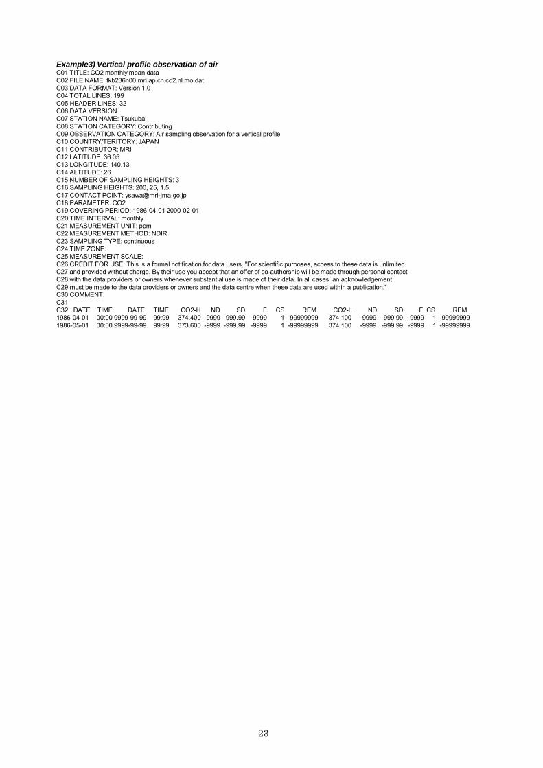
Example3) Vertical profile observation of air C01 TITLE: CO2 monthly mean data C02 FILE NAME: tkb236n00.mri.ap.cn.co2.nl.mo.dat C03 DATA FORMAT: Version 1.0 C04 TOTAL LINES: 199 C05 HEADER LINES: 32 C06 DATA VERSION: C07 STATION NAME: Tsukuba C08 STATION CATEGORY: Contributing C09 OBSERVATION CATEGORY: Air sampling observation for a vertical profile C10 COUNTRY/TERITORY: JAPAN C11 CONTRIBUTOR: MRI C12 LATITUDE: 36.05 C13 LONGITUDE: 140.13 C14 ALTITUDE: 26 C15 NUMBER OF SAMPLING HEIGHTS: 3 C16 SAMPLING HEIGHTS: 200, 25, 1.5 C17 CONTACT POINT: [email protected] C18 PARAMETER: CO2 C19 COVERING PERIOD: 1986-04-01 2000-02-01 C20 TIME INTERVAL: monthly C21 MEASUREMENT UNIT: ppm C22 MEASUREMENT METHOD: NDIR C23 SAMPLING TYPE: continuous C24 TIME ZONE: C25 MEASUREMENT SCALE: C26 CREDIT FOR USE: This is a formal notification for data users. "For scientific purposes, access to these data is unlimited C27 and provided without charge. By their use you accept that an offer of co-authorship will be made through personal contact C28 with the data providers or owners whenever substantial use is made of their data. In all cases, an acknowledgement C29 must be made to the data providers or owners and the data centre when these data are used within a publication." C30 COMMENT: C31 C32 DATE TIME DATE TIME CO2-H ND SD F CS REM CO2-L ND SD F CS REM
24
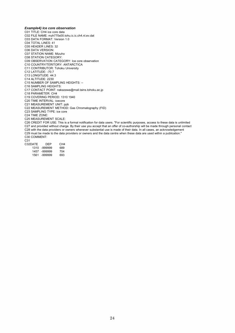
Example4) Ice core observation C01 TITLE: CH4 ice core data C02 FILE NAME: mzh770s00.tohu.ic.ic.ch4.nl.ev.dat C03 DATA FORMAT: Version 1.0 C04 TOTAL LINES: 41 C05 HEADER LINES: 32 C06 DATA VERSION: C07 STATION NAME: Mizuho C08 STATION CATEGORY: C09 OBSERVATION CATEGORY: Ice core observation C10 COUNTRY/TERITORY: ANTARCTICA C11 CONTRIBUTOR: Tohoku University C12 LATITUDE: -70.7 C13 LONGITUDE: 44.3 C14 ALTITUDE: 2230 C15 NUMBER OF SAMPLING HEIGHTS: -- C16 SAMPLING HEIGHTS: C17 CONTACT POINT: [email protected] C18 PARAMETER: CH4 C19 COVERING PERIOD: 1310 1940 C20 TIME INTERVAL: icecore C21 MEASUREMENT UNIT: ppb C22 MEASUREMENT METHOD: Gas Chromatography (FID) C23 SAMPLING TYPE: ice core C24 TIME ZONE: C25 MEASUREMENT SCALE: C26 CREDIT FOR USE: This is a formal notification for data users. "For scientific purposes, access to these data is unlimited C27 and provided without charge. By their use you accept that an offer of co-authorship will be made through personal contact C28 with the data providers or owners whenever substantial use is made of their data. In all cases, an acknowledgement C29 must be made to the data providers or owners and the data centre when these data are used within a publication." C30 COMMENT: C31 C32DATE DEP CH4
1310 -999999 689 1457 -999999 704 1561 -999999 693
25
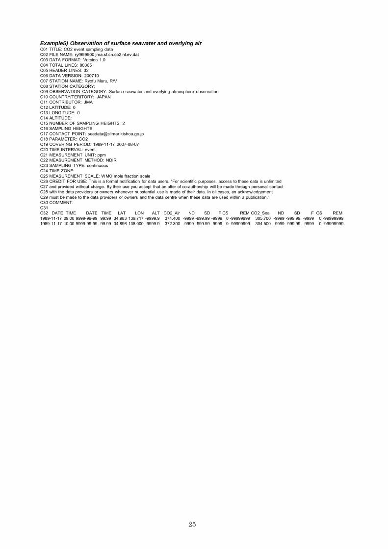
Example5) Observation of surface seawater and overlying air C01 TITLE: CO2 event sampling data C02 FILE NAME: ryf999900.jma.sf.cn.co2.nl.ev.dat C03 DATA FORMAT: Version 1.0 C04 TOTAL LINES: 88365 C05 HEADER LINES: 32 C06 DATA VERSION: 200710 C07 STATION NAME: Ryofu Maru, R/V C08 STATION CATEGORY: C09 OBSERVATION CATEGORY: Surface seawater and overlying atmosphere observation C10 COUNTRY/TERITORY: JAPAN C11 CONTRIBUTOR: JMA C12 LATITUDE: 0 C13 LONGITUDE: 0 C14 ALTITUDE: C15 NUMBER OF SAMPLING HEIGHTS: 2 C16 SAMPLING HEIGHTS: C17 CONTACT POINT: [email protected] C18 PARAMETER: CO2 C19 COVERING PERIOD: 1989-11-17 2007-08-07 C20 TIME INTERVAL: event C21 MEASUREMENT UNIT: ppm C22 MEASUREMENT METHOD: NDIR C23 SAMPLING TYPE: continuous C24 TIME ZONE: C25 MEASUREMENT SCALE: WMO mole fraction scale C26 CREDIT FOR USE: This is a formal notification for data users. "For scientific purposes, access to these data is unlimited C27 and provided without charge. By their use you accept that an offer of co-authorship will be made through personal contact C28 with the data providers or owners whenever substantial use is made of their data. In all cases, an acknowledgement C29 must be made to the data providers or owners and the data centre when these data are used within a publication." C30 COMMENT: C31 C32 DATE TIME DATE TIME LAT LON ALT CO2_Air ND SD F CS REM CO2_Sea ND SD F CS REM 1989-11-17 09:00 9999-99-99 99:99 34.983 139.717 -9999.9 374.400 -9999 -999.99 -9999 0 -99999999 305.700 -9999 -999.99 -9999 0 -99999999 1989-11-17 10:00 9999-99-99 99:99 34.896 138.000 -9999.9 372.300 -9999 -999.99 -9999 0 -99999999 304.500 -9999 -999.99 -9999 0 -99999999

26
Example6) meteorological data (hourly) C01 TITLE: hourly meteorological data C02 FILE NAME: mnm224n00.jma.xx.xx.met.nl.hr2009.dat C03 DATA FORMAT: Version 1.0 C04 TOTAL LINES: 1448 C05 HEADER LINES: 32 C06 DATA VERSION: 200711 C07 STATION NAME: Minamitorishima C08 STATION CATEGORY: Global C09 C10 COUNTRY/TERITORY: Japan C11 CONTRIBUTOR: JMA C12 LATITUDE: 24.28 C13 LONGITUDE: 153.98 C14 ALTITUDE: 8 C15 C16 C17 C18 PARAMETER: WD WS RH AT C19 COVERING PERIOD: 2009-01-01 2009-02-28 C20 TIME INTERVAL: hourly C21 C22 C23 C24 TIME ZONE: LOCAL TIME UTC+9 C25 C26 CREDIT FOR USE: This is a formal notification for data users. "For scientific purposes, access to these data is unlimited C27 and provided without charge. By their use you accept that an offer of co-authorship will be made through personal contact C28 with the data providers or owners whenever substantial use is made of their data. In all cases, an acknowledgement C29 must be made to the data providers or owners and the data centre when these data are used within a publication." C30 COMMENT: C31 C32 DATE TIME WD WS RH AT 2009-01-01 01:00 270.0 6.0 75.0 24.8 2009-01-01 02:00 270.0 6.1 76.0 24.9
27
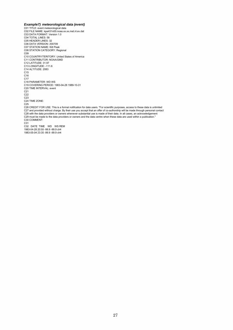
Example7) meteorological data (event) C01 TITLE: event meteorological data C02 FILE NAME: kpa431n00.noaa.xx.xx.met.nl.ev.dat C03 DATA FORMAT: Version 1.0 C04 TOTAL LINES: 58 C05 HEADER LINES: 32 C06 DATA VERSION: 200709 C07 STATION NAME: Kitt Peak C08 STATION CATEGORY: Regional C09 C10 COUNTRY/TERITORY: United States of America C11 CONTRIBUTOR: NOAA/GMD C12 LATITUDE: 31.97 C13 LONGITUDE: -111.6 C14 ALTITUDE: 2083 C15 C16 C17 C18 PARAMETER: WD WS C19 COVERING PERIOD: 1983-04-28 1989-10-31 C20 TIME INTERVAL: event C21 C22 C23 C24 TIME ZONE: C25 C26 CREDIT FOR USE: This is a formal notification for data users. "For scientific purposes, access to these data is unlimited C27 and provided without charge. By their use you accept that an offer of co-authorship will be made through personal contact C28 with the data providers or owners whenever substantial use is made of their data. In all cases, an acknowledgement C29 must be made to the data providers or owners and the data centre when these data are used within a publication." C30 COMMENT: C31 C32 DATE TIME WD WS REM 1983-04-28 20:55 -99.9 -99.9 ch4 1983-05-04 23:35 -99.9 -99.9 ch4
28
ANNEX 5
Metadata Statement
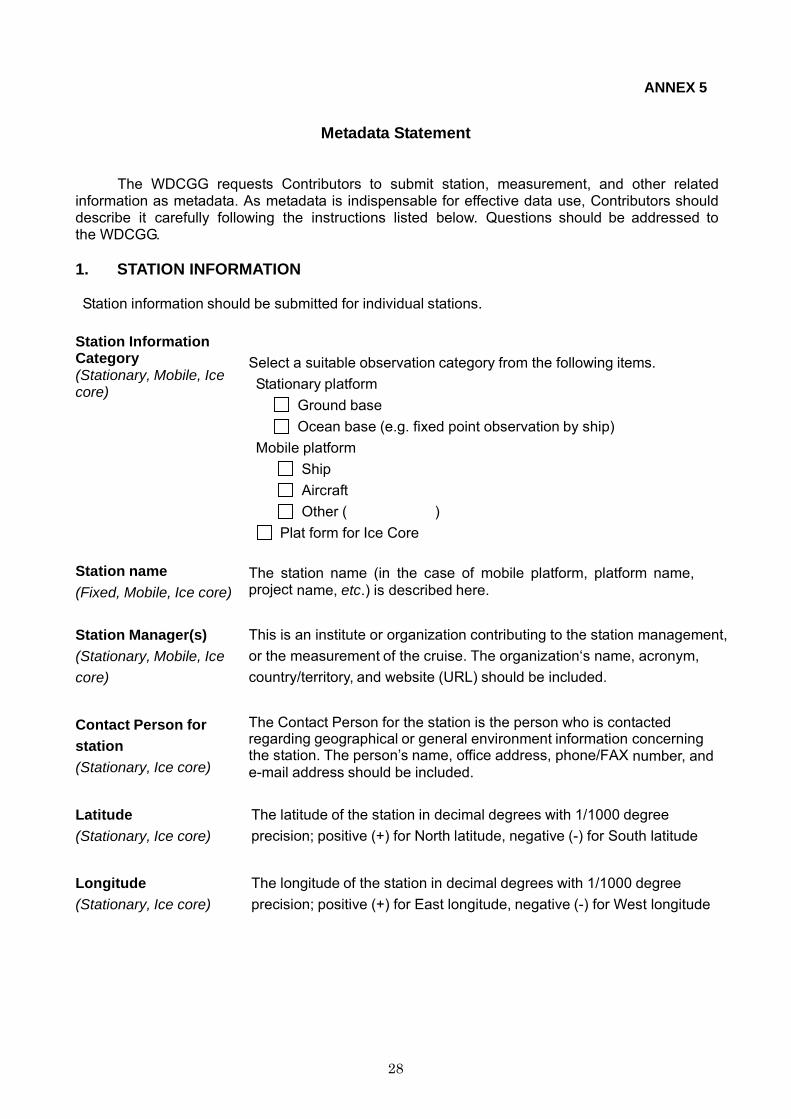
The WDCGG requests Contributors to submit station, measurement, and other related information as metadata. As metadata is indispensable for effective data use, Contributors should describe it carefully following the instructions listed below. Questions should be addressed to the WDCGG.
1. STATION INFORMATION
Station information should be submitted for individual stations.
Station Information Category (Stationary, Mobile, Ice core)
Select a suitable observation category from the following items. Stationary platform
Ground base Ocean base (e.g. fixed point observation by ship)
Mobile platform Ship Aircraft Other ( )
Plat form for Ice Core Station name (Fixed, Mobile, Ice core)
The station name (in the case of mobile platform, platform name, project name, etc.) is described here.
Station Manager(s) (Stationary, Mobile, Ice core)
This is an institute or organization contributing to the station management, or the measurement of the cruise. The organization‘s name, acronym, country/territory, and website (URL) should be included.
Contact Person for station (Stationary, Ice core)
The Contact Person for the station is the person who is contacted regarding geographical or general environment information concerning the station. The person’s name, office address, phone/FAX number, and e-mail address should be included.
Latitude (Stationary, Ice core)
The latitude of the station in decimal degrees with 1/1000 degree precision; positive (+) for North latitude, negative (-) for South latitude
Longitude (Stationary, Ice core)
The longitude of the station in decimal degrees with 1/1000 degree precision; positive (+) for East longitude, negative (-) for West longitude
29
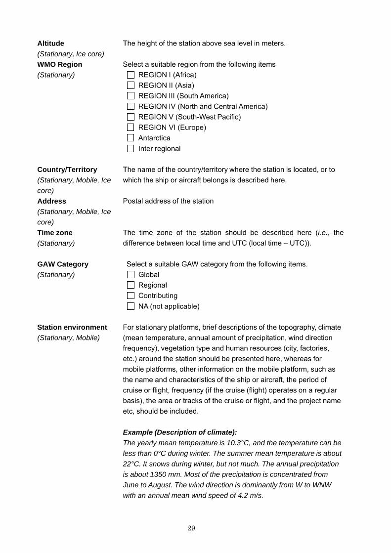
Altitude (Stationary, Ice core) WMO Region (Stationary)
The height of the station above sea level in meters. Select a suitable region from the following items
REGION I (Africa) REGION II (Asia) REGION III (South America) REGION IV (North and Central America) REGION V (South-West Pacific) REGION VI (Europe) Antarctica Inter regional
Country/Territory (Stationary, Mobile, Ice core) Address (Stationary, Mobile, Ice core) Time zone (Stationary)
The name of the country/territory where the station is located, or to which the ship or aircraft belongs is described here. Postal address of the station The time zone of the station should be described here (i.e., the difference between local time and UTC (local time – UTC)).
GAW Category (Stationary)
Select a suitable GAW category from the following items. Global Regional Contributing NA (not applicable)
Station environment (Stationary, Mobile)
For stationary platforms, brief descriptions of the topography, climate (mean temperature, annual amount of precipitation, wind direction frequency), vegetation type and human resources (city, factories, etc.) around the station should be presented here, whereas for mobile platforms, other information on the mobile platform, such as the name and characteristics of the ship or aircraft, the period of cruise or flight, frequency (if the cruise (flight) operates on a regular basis), the area or tracks of the cruise or flight, and the project name etc, should be included. Example (Description of climate): The yearly mean temperature is 10.3°C, and the temperature can be less than 0°C during winter. The summer mean temperature is about 22°C. It snows during winter, but not much. The annual precipitation is about 1350 mm. Most of the precipitation is concentrated from June to August. The wind direction is dominantly from W to WNW with an annual mean wind speed of 4.2 m/s.
30
Example (Description of vegetation type and human resources): The observatory is surrounded by insignificant shrubs and grass. The nearest town is the city of Groningen (168,000 inhabitants) at a distance of about 25 km in the ESE direction. The annual frequency of ESE winds, which could carry pollution from the city directly, is usually less than 1%.
Example (Aircraft): Uses a regular Boeing 747-200 flight (typical cruise speed: 895 km/h) of a commercial airliner over the western Pacific between Narita in Japan (35N) and Cairns in Australia (30S).
2. MEASUREMENT INFORMATION
The measurement information should be submitted for individual parameters.
2.1 Parameter Parameter Select a parameter (gas name) from Table 2 to Table 6 in Annex 1.
Contributor(s) The Contributor is the institute or organization who obtains and submits
the measurement data (see Section 2.2.1 in Guide). The organization‘s name, acronym, country/territory, and website (URL) are included. In some cases, the Station Managers for the measurement may be different from Station Managers for the station.
Contact Person for measurement
The Contact Person for measurement is the person who is contacted regarding the submission of data and the measurement information (see Section 2.2.5 in Guide). This person’s name, office address, phone/FAX number, and e-mail address should be included.
Responsible Investigator (optional)
The Responsible Investigator is the person who is officially or scientifically responsible for the observation (see Section 2.2.6). This person’s name, office address, phone/FAX number, and e-mail address should be included.
2.2 Observation Category Select a suitable category from the following items.
Air sampling observation at a stationary platform Air sampling observation for a vertical profile at a stationary platform Air sampling observation by a mobile platform Ice core observation Surface seawater and overlying atmosphere observation Hydrographic sampling observation
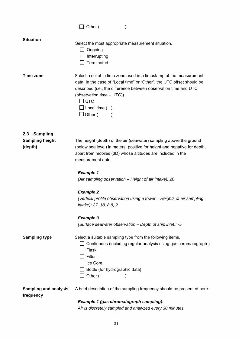
31
Other ( ) Situation
Select the most appropriate measurement situation. Ongoing Interrupting Terminated
Time zone Select a suitable time zone used in a timestamp of the measurement
data. In the case of “Local time” or “Other”, the UTC offset should be described (i.e., the difference between observation time and UTC (observation time – UTC)).
UTC Local time ( ) Other ( )
2.3 Sampling Sampling height (depth)
The height (depth) of the air (seawater) sampling above the ground (below sea level) in meters; positive for height and negative for depth, apart from mobiles (3D) whose altitudes are included in the measurement data.
Example 1 (Air sampling observation – Height of air intake): 20
Example 2 (Vertical profile observation using a tower – Heights of air sampling intake): 27, 18, 8.8, 2
Example 3 (Surface seawater observation – Depth of ship inlet): -5
Sampling type Select a suitable sampling type from the following items.
Continuous (including regular analysis using gas chromatograph ) Flask Filter Ice Core Bottle (for hydrographic data) Other ( )
Sampling and analysis frequency
A brief description of the sampling frequency should be presented here.
Example 1 (gas chromatograph sampling): Air is discretely sampled and analyzed every 30 minutes
32
Example 2 (flask sampling): Air is sampled in a bottle every week.
Example 3 (continuous measurement): Continuous flow of 5 litres per minute and data is analyzed every 30 seconds.
Sampling environment A brief description of the information on sources and sinks on the
measurement gas measured should be presented here.
Example 1: The station is located in an agricultural plain with some forests that could affect the CO2 mole fractions in calm conditions.
Example 2: The station is surrounded by forests and on the southeast side of the middle (230 m a.s.l.) of a small hill on the east coast of northern Japan. While a power plant using fossil fuel, which could affect the CO2 mole fractions, is located 10 km south of the station, the frequency of southerly winds is usually less than 8%. In the case of southerly winds, the measurement data is flagged.
Other description for sampling and analyses
Detailed descriptions concerning sampling should be presented here. For example, information on air sampling intake (height, shape, materials, etc.), tubing (materials, diameter, and length, etc.), flow rate, and dehumidification for in situ measurements, bottles used (volume and material) for flask sampling, and procedures or conditions for flask sampling etc.
Example 1 (Stationary platform – Flask sampling observation): Air is sampled in a bottle once a week during northerly wind conditions. The sampled air is compressed to 0.2 MPa in the bottle by a compressor after a 5-minute ventilation.
Example 2 (Stationary platform – Continuous observation): Air is sampled from a stainless steel intake at 10 m height with 15 litres min-1. The sampled air is introduced to a dehumidification instrument for 10 m through a stainless steel pipe with a diameter of one inch. After dehumidifying to 3 ºC, the sampled air is divided and introduced to the instrument with 3 litres min-1 through a 4 m stainless steel pipe with a diameter of a quarter inch.
33
Example 3 (Mobile Ship – Surface seawater and overlying atmosphere): The measurements are made in a 60-minute cycle, and standard gases, water samples, and air samples from the ocean surface are measured in the following order in each cycle: Four standard gases are measured for 6 minutes each, 1 water sample is measured for 12 minutes, 2 air samples from the ocean surface are measured for 6 minutes each, and 1 water sample is measured for 12 minutes. For CO2 in the atmosphere, marine boundary air was pumped continuously from the foremast (about 13 m above sea level), and an aliquot (250 cm3 min-1) was dried with an electric cooling unit and magnesium perchlorate before introducing it into the NDIR gas analyzer. For CO2 in seawater, the seawater sample was pumped continuously from a ship inlet located ca. 5 m below sea level. It was partly introduced into a shower-type equilibrator (ca. 6 dm3 min-1) where the seawater was equilibrated with air in a closed circuit. The seawater-equilibrated air was dried in the same way as the marine boundary air.
Example 4 (Mobile Ship – Hydrographic data): Discrete samples were taken from depths using 12-L Niskin bottles mounted on a CTD/carousel sampler. Sub-samples for DIC analysis were stored in 250-cm3 ground glass stoppered borosilicate glass bottles lubricated with Apiezon-L grease after adding 0.1 cm3 of saturated mercury (II) chloride solution.
2.4 Instrument and analyses Measurement Method Select a suitable method from the following items.
Gas Chromatography (ECD) Gas Chromatography (FID) Gas Chromatography (RGD) Gas Chromatography (MS) Gas Chromatography (other) Ion Chromatography Light absorption analysis (UV) Light absorption analysis (VIS) NDIR Light absorption analysis (IR, except NDIR) Chemiluminescence Fluorometry Coulometry Mass Spectrometry Spectroscopy
34
Titration Filter Other ( )
Current status and history of instruments
The period in use, product name, and manufacturer of the instrument are described.
Example 1 (CO2): Period in use Product Name Manufacturer 1988 April - 1998 April, VIA-500R, Horiba Ltd. 1998 June - present, VIA-510R, Horiba Ltd.
Example 2 (Surface O3): Period in use Product Name Manufacturer 1984 January-1988 March, Original ozone meter using KI method,
made by Research Institute 1988 April - 1998 May, Model 1003PC, Dasibi Corporation1998 June - present, Model 49C, TEI Corporation
Description of instruments
The instrument specifications (resolution, measurement range, and linearity, etc,) are described here.
Example: Range: 0 to 1000 ppm. Sensitivity: The minimum detectable mole fraction is 0.2 ppm for a 0–1000 ppm span. Precision: approximately 2 percent of span. Accuracy: approximately 5 percent of span after calibration. Rise time: 90 percent (maximum) 30 seconds Fall time: 90 percent (maximum) 30 seconds Zero drift: (maximum) 10% in 8 hours Span drift (maximum) 10% in 8 hours Linearity (maximum deviation) 2% of full scale
2.5 Calibration Current scale employed in the measurement
The clarification of the current scale used in the measurement should be described here. Note: Concerning the WMO reference standard, please refer to WMO
GAW Report No.172 “WMO Global Atmosphere Watch (GAW) Strategic Plan: 2008-2015”.
Example 1: WMO X2005 Example 2: NOAA2004 scale Example 3: Traceable to Tohoku University Standard gases Example 4: GAW reference standard scale hosted by NIST Example 5: Observer’s standard scale
35
Example 6: Traceable to national standard scale Measurement calibration
The calibration for determining the mole fractions is described here. Procedures for analyses are also described here, for example, the introduction order (sequences) of sample gas and standard gases (or zero gas) to the instrument, their duration, the number of calibration points, etc.
Example 1 (CO2): The non-linear fitting curve is determined every 4 days by a set of 5 station working standard gases in a pyramid manner with 10 minutes for each stage. The mole fractions are determined by this fitting curve. Every day, target gas is introduced to check the system performance.
Example 2 (CH4): The mole fractions are determined by the liner regression line determined every hour by two working standard gases that closely bracket the ambient mole fractions. Every 8 hours, target gas is introduced after the two working standard gases. The difference between the assigned mole fractions and the measured mole fractions is a measure of the overall system performance.
Example 3 (Surface O3): The zero level of the instrument is checked every day. The 4 span gases (50, 100, 150, 200 ppb) from the transfer standard instrument are introduced once a month. The mole fractions are determined by the linear regression line from zero level and the 4 spans.
Scale and Calibration (traceability)
Detailed descriptions of information on scales employed and calibration of standard gases (instrument) are given here. For example, information on the hierarchy of standards (headquarters and station), reference standard gases (instruments), frequency of calibration and the latest calibration, history of calibration, and information on intercomparison. Hierarchy of standards
Example: The laboratory primary standard gases are calibrated by WMO reference standard gases. The laboratory secondary standard gases are calibrated by the laboratory primary standard gases. The working standard gases in the station are calibrated by the laboratory secondary standard gases.
Reference standard (in the case of observer’s standard scale)
36
Example 1 (CH4): Two standard gases were made by Nippon Sanso Inc. in 2004 using a gravimetric method whose production method was developed and maintained by Tohoku University. Their mole fractions were about 1800 and 2000 ppb and their lifetime will be about 4 years.
Example 2 (Surface O3): A standard UV photometer (Thermo Electron Corp. Model 49PS), which was calibrated by the manufacturer in 2003, was used. The instrument is calibrated by the manufacturer every two years.
Frequency of calibration and latest calibration
Example 1 (CO2): The laboratory primary standard gases are calibrated by WMO reference standard gases at WMO CCL every 3 years. The latest calibration at CCL was performed in November 2003. The laboratory secondary standard gases are calibrated by the laboratory primary standard every 6 months. The working standard gases in the station are calibrated by the laboratory secondary standard gases before and after use (period of use is about 3-4 months).
Example 2 (Surface O3): The laboratory standard instrument (Thermo Electron Corp. Model 49PS) is compared with NIST SRP #15 at the WMO World Calibration Centre, Empa, Materials Science and Technology, every 3 years. The latest calibration was performed in April 2004. The transfer standard ozone monitor, which is a Thermo Electron Corp. Model 49C, is calibrated by the laboratory standard instrument every 6 months.
Calibration history
Example 1 (CO2): 1st generation (1988 Apr. – 1991 Apr.)
Calibration date (Calibration standard) 1987 Apr. at SIO (WMO X85) 1991 May at SIO (WMO X85)
2nd generation (1991 Apr. – 1998 Jun.) Calibration date (Calibration standard) 1990 Apr. at SIO (WMO X87) 1994 Apr. at SIO (WMO X93) 1999 Jul. at CMDL (WMO Mole Fraction)
3rd generation (1998 Jun.-)
1997 Apr. at CMDL (WMO Mole Fraction) 2000 Apr. at CMDL (WMO Mole Fraction)
37
2006 Jun. at NOAA/ESRL/GMD (WMO X2005)
Example 2 (Surface O3): 1984 April – 1988 March: Original ozone generator using KI method. 1988 April – 1998 May: TEI Model 49PS with the EPA certification 1998 June – present: TEI Model 49PS which is calibrated with the WMO reference standard (SRP) at NIST every two years.
Information on intercomparison
Example: 1. WMO CO2 round robin 1991/1992 (WMO, SIO: 1991-1992) Analysis date: 1991-05 Remark: WMO/GAW report #X2 2. WMO CO2 round robin 1999/2000 (WMO, CMDL: 1999-2000) Analysis date: 1999-11 Remark: WMO/GAW report #X2 The results are available on the internet (http://…)
2.6 Data Processing Measurement Unit The measurement unit is described here.
Data Processing Details of how to process and average outputs from the instrument are
described here. The criteria used for any data selection in the data processing are also described.
Processes for averaging
Example: The raw data from the instrument is collected by the data acquisition system, and stored in the system as one minute average raw data. The minutely averaged raw data is converted to physical data using zero/calibration factors measured in the observation sequences. Invalid data caused by instrumental malfunction are checked by comparison/correlation with other trace substances and meteorological data or with information from the station logbook.
Detailed processes on hourly, daily, monthly data or data selections on qualities are described.
Example: Hourly data are generated by arithmetic means from the per-minute data without including invalid data. If the most frequent hourly wind direction is not W-SW, the corresponding hourly data is flagged as “0”. Otherwise, hourly data is flagged as “1”. If the number of valid data within an hour is less than 30, the hourly mean value is flagged as “2”. If all data within an hour are invalid, the hourly mean value is “-999.9”.
38
The arithmetic means of hourly data are adopted as daily data with a “0” flag if more than 80% of hourly data with a “0” flag are available. Otherwise, daily data is flagged as “2”. If all data within a day are invalid (-999.9), daily data is “-999.9”. The arithmetic means of daily data are adopted as monthly data with a “0” flag if more than 1/3 of daily data with a “0” flag are available. Otherwise, monthly data is flagged as “2”. If all data within a month are invalid (-999.9), monthly data is “-999.9”.
Data flag The WDCGG does not have a common definition on data flagging, and Contributors should define their own data flags, and make clear their criteria of data flagging.
Example 1: Flag: Data Category 0: Background data 1: Data possibly affected by pollution (wind direction is W - SW) 2: Insufficient number of averaging data 3: Invalid data
Example 2: Flag Criteria1 Criteria2 Data Category
(Insufficient number of data) (High standard deviation)
0 Yes Yes Out of background 1 No Yes Ditto 2 Yes No Ditto 3 No No Background condition data
Data Remarks Data submitters who submit data with data remarks should provide a
definition.
Example: Remarks are expressed as “xxxx c.” The meanings of the symbols are as follows: xxxx : Flask ID number c : Sampling collection method code. Here, “p” means a portable, battery powered pump, “T” means an evacuated flask, and “S” means using the in situ CO2 measurement air intake system.
3. OTHER INFORMATION
Scientific Aim Descriptions of the aims of measurement are presented here.
Example 1: To provide data for research and study to reveal long term trends.
39
Example 2: To monitor suburban regions for pollution research.
Example 3: To quantify fluxes for budget estimation with a limited observation period (campaign research).
Reference Any references to the measurement, such as the instruments, data
processing, and calibration, in the literature or URLs should be described here.
Example: Tsutsumi, Y., K. Mori, M. Ikegami, T. Tashiro, K. Tsuboi, 2006: Long-term trends of greenhouse gases in regional and background events observed during 1998-2004 at Yonagunijima located to the east of the Asian continent. Atmospheric Environment, 40, 5868-5879.
http://gaw.kishou.go.jp/japan/ryo.html
****
40
ABBREVIATION AND ACRONYMS
CCL: Central Calibration Laboratory CMDL: Climate and Monitoring Diagnostics Laboratory ECD: Electron Capture Detector ESRL: Earth System Research Laboratory
FID: Flame Ionization Detector GAW: Global Atmosphere Watch GAWSIS: GAW Station Information System GMD: Global Monitoring Division IR: Infrared MS: Mass spectrometry NDIR: Non-Dispersive InfraRed gas analyzer NIST: National Institute of Standards and Technology
NOAA: (US) National Oceanic and Atmospheric Administration ppm (ppb, or ppt): parts per million (106) (billion – 109, or trillion – 1012). QA/SAC: Quality Assurance/Science Activity Centre RGD: Reduction Gas Detector SAG: Scientific Advisory Group SIO: Scripps Institution of Oceanography SRP: Standard Reference Photometer UTC: Coordinated Universal Time UV: Ultra Violet VIS: Visible WCC: World Calibration Centre WDCGG: World Data Centre for Greenhouse Gases
41
GLOBAL ATMOSPHERE WATCH REPORT SERIES
1. Final Report of the Expert Meeting on the Operation of Integrated Monitoring Programmes, Geneva, 2 -5 September 1980.
2. Report of the Third Session of the GESAMP Working Group on the Interchange of Pollutants
Between the Atmosphere and the Oceans (INTERPOLL-III), Miami, USA, 27 - 31 October 1980.
3. Report of the Expert Meeting on the Assessment of the Meteorological Aspects of the First Phase of EMEP, Shinfield Park, U.K., 30 March - 2 April 1981.
4. Summary Report on the Status of the WMO Background Air Pollution Monitoring Network as at April
1981.
5. Report of the WMO/UNEP/ICSU Meeting on Instruments, Standardization and Measurements Techniques for Atmospheric CO2, Geneva, 8-11; September 1981.
6. Report of the Meeting of Experts on BAPMoN Station Operation, Geneva, 23–26 November 1981.
7. Fourth Analysis on Reference Precipitation Samples by the Participating World Meteorological
Organization Laboratories by Robert L. Lampe and John C. Puzak, December 1981.
8. Review of the Chemical Composition of Precipitation as Measured by the WMO BAPMoN by Prof. Dr Hans-Walter Georgii, February 1982.
9. An Assessment of BAPMoN Data Currently Available on the Concentration of CO2 in the Atmosphere
by M.R. Manning, February 1982.
10. Report of the Meeting of Experts on Meteorological Aspects of Long-range Transport of Pollutants, Toronto, Canada, 30 November - 4 December 1981.
11. Summary Report on the Status of the WMO Background Air Pollution Monitoring Network as at May
1982.
12. Report on the Mount Kenya Baseline Station Feasibility Study edited by Dr. Russell C. Schnell.
13. Report of the Executive Committee Panel of Experts on Environmental Pollution, Fourth Session, Geneva, 27 September - 1 October 1982.
14. Effects of Sulphur Compounds and Other Pollutants on Visibility by Dr. R.F. Pueschel, April 1983.
15. Provisional Daily Atmospheric Carbon Dioxide Concentrations as Measured at BAPMoN Sites for the
Year 1981, May 1983.
16. Report of the Expert Meeting on Quality Assurance in BAPMoN, Research Triangle Park, North Carolina, USA, 17-21 January 1983.
17. General Consideration and Examples of Data Evaluation and Quality Assurance Procedures
Applicable to BAPMoN Precipitation Chemistry Observations by Dr. Charles Hakkarinen, July 1983.
18. Summary Report on the Status of the WMO Background Air Pollution Monitoring Network as at May 1983.
19. Forecasting of Air Pollution with Emphasis on Research in the USSR by M.E. Berlyand, August 1983.
20. Extended Abstracts of Papers to be Presented at the WMO Technical Conference on Observation
and Measurement of Atmospheric Contaminants (TECOMAC), Vienna, 17-21 October 1983.
21. Fifth Analysis on Reference Precipitation Samples by the Participating World Meteorological Organization Laboratories by Robert L. Lampe and William J. Mitchell, November 1983.
42
22. Report of the Fifth Session of the WMO Executive Council Panel of Experts on Environmental Pollution, Garmisch-Partenkirchen, Federal Republic of Germany, 30 April - 4 May 1984 (WMO TD No. 10).
23. Provisional Daily Atmospheric Carbon Dioxide Concentrations as Measured at BAPMoN Sites for the
Year 1982. November 1984 (WMO TD No. 12).
24. Final Report of the Expert Meeting on the Assessment of the Meteorological Aspects of the Second Phase of EMEP, Friedrichshafen, Federal Republic of Germany, 7-10 December 1983. October 1984 (WMO TD No. 11).
25. Summary Report on the Status of the WMO Background Air Pollution Monitoring Network as at May
1984. November 1984 (WMO TD No. 13).
26. Sulphur and Nitrogen in Precipitation: An Attempt to Use BAPMoN and Other Data to Show Regional and Global Distribution by Dr. C.C. Wallén. April 1986 (WMO TD No. 103).
27. Report on a Study of the Transport of Sahelian Particulate Matter Using Sunphotometer
Observations by Dr. Guillaume A. d'Almeida. July 1985 (WMO TD No. 45).
28. Report of the Meeting of Experts on the Eastern Atlantic and Mediterranean Transport Experiment ("EAMTEX"), Madrid and Salamanca, Spain, 6-8 November 1984.
29. Recommendations on Sunphotometer Measurements in BAPMoN Based on the Experience of a
Dust Transport Study in Africa by Dr. Guillaume A. d'Almeida. September 1985 (WMO TD No. 67).
30. Report of the Ad-hoc Consultation on Quality Assurance Procedures for Inclusion in the BAPMoN Manual, Geneva, 29-31 May 1985.
31. Implications of Visibility Reduction by Man-Made Aerosols (Annex to No. 14) by R.M. Hoff and L.A.
Barrie. October 1985 (WMO TD No. 59).
32. Manual for BAPMoN Station Operators by E. Meszaros and D.M. Whelpdale. October 1985 (WMO TD No. 66).
33. Man and the Composition of the Atmosphere: BAPMoN - An international programme of national
needs, responsibility and benefits by R.F. Pueschel, 1986.
34. Practical Guide for Estimating Atmospheric Pollution Potential by Dr. L.E. Niemeyer. August 1986 (WMO TD No. 134).
35. Provisional Daily Atmospheric CO2 Concentrations as Measured at BAPMoN Sites for the Year 1983.
December 1985 (WMO TD No. 77).
36. Global Atmospheric Background Monitoring for Selected Environmental Parameters. BAPMoN Data for 1984. Volume I: Atmospheric Aerosol Optical Depth. October 1985 (WMO TD No. 96).
37. Air-Sea Interchange of Pollutants by R.A. Duce. September 1986 (WMO TD No. 126).
38. Summary Report on the Status of the WMO Background Air Pollution Monitoring Network as at 31
December 1985. September 1986 (WMO TD No. 136).
39. Report of the Third WMO Expert Meeting on Atmospheric Carbon Dioxide Measurement Techniques, Lake Arrowhead, California, USA, 4-8 November 1985. October 1986.
40. Report of the Fourth Session of the CAS Working Group on Atmospheric Chemistry and Air Pollution,
Helsinki, Finland, 18-22 November 1985. January 1987.
41. Global Atmospheric Background Monitoring for Selected Environmental Parameters. BAPMoN Data for 1982, Volume II: Precipitation chemistry, continuous atmospheric carbon dioxide and suspended particulate matter. June 1986 (WMO TD No. 116).
43
42. Scripps reference gas calibration system for carbon dioxide-in-air standards: revision of 1985 by C.D. Keeling, P.R. Guenther and D.J. Moss. September 1986 (WMO TD No. 125).
43. Recent progress in sunphotometry (determination of the aerosol optical depth). November 1986.
44. Report of the Sixth Session of the WMO Executive Council Panel of Experts on Environmental
Pollution, Geneva, 5-9 May 1986. March 1987.
45. Proceedings of the International Symposium on Integrated Global Monitoring of the State of the Biosphere (Volumes I-IV), Tashkent, USSR, 14-19 October 1985. December 1986 (WMO TD No. 151).
46. Provisional Daily Atmospheric Carbon Dioxide Concentrations as Measured at BAPMoN Sites for the
Year 1984. December 1986 (WMO TD No. 158).
47. Procedures and Methods for Integrated Global Background Monitoring of Environmental Pollution by F.Ya. Rovinsky, USSR and G.B. Wiersma, USA. August 1987 (WMO TD No. 178).
48. Meeting on the Assessment of the Meteorological Aspects of the Third Phase of EMEP IIASA,
Laxenburg, Austria, 30 March - 2 April 1987. February 1988.
49. Proceedings of the WMO Conference on Air Pollution Modelling and its Application (Volumes I-III), Leningrad, USSR, 19-24 May 1986. November 1987 (WMO TD No. 187).
50. Provisional Daily Atmospheric Carbon Dioxide Concentrations as Measured at BAPMoN Sites for the
Year 1985. December 1987 (WMO TD No. 198).
51. Report of the NBS/WMO Expert Meeting on Atmospheric CO2 Measurement Techniques, Gaithersburg, USA, 15-17 June 1987. December 1987.
52. Global Atmospheric Background Monitoring for Selected Environmental Parameters. BAPMoN Data
for 1985. Volume I: Atmospheric Aerosol Optical Depth. September 1987.
53. WMO Meeting of Experts on Strategy for the Monitoring of Suspended Particulate Matter in BAPMoN -Reports and papers presented at the meeting, Xiamen, China, 13-17 October 1986. October 1988.
54. Global Atmospheric Background Monitoring for Selected Environmental Parameters. BAPMoN Data
for 1983, Volume II: Precipitation chemistry, continuous atmospheric carbon dioxide and suspended particulate matter (WMO TD No. 283).
55. Summary Report on the Status of the WMO Background Air Pollution Monitoring Network as at
31 December 1987 (WMO TD No. 284).
56. Report of the First Session of the Executive Council Panel of Experts/CAS Working Group on Environmental Pollution and Atmospheric Chemistry, Hilo, Hawaii, 27-31 March 1988. June 1988.
57. Global Atmospheric Background Monitoring for Selected Environmental Parameters. BAPMoN Data
for 1986, Volume I: Atmospheric Aerosol Optical Depth. July 1988.
58. Provisional Daily Atmospheric Carbon Dioxide Concentrations as measured at BAPMoN sites for the years 1986 and 1987 (WMO TD No. 306).
59. Extended Abstracts of Papers Presented at the Third International Conference on Analysis and
Evaluation of Atmospheric CO2 Data - Present and Past, Hinterzarten, Federal Republic of Germany, 16-20 October 1989 (WMO TD No. 340).
60. Global Atmospheric Background Monitoring for Selected Environmental Parameters. BAPMoN Data
for 1984 and 1985, Volume II: Precipitation chemistry, continuous atmospheric carbon dioxide and suspended particulate matter.
61. Global Atmospheric Background Monitoring for Selected Environmental Parameters. BAPMoN Data
for 1987 and 1988, Volume I: Atmospheric Aerosol Optical Depth.
44
62. Provisional Daily Atmospheric Carbon Dioxide Concentrations as measured at BAPMoN sites for the year 1988 (WMO TD No. 355).
63. Report of the Informal Session of the Executive Council Panel of Experts/CAS Working Group on
Environmental Pollution and Atmospheric Chemistry, Sofia, Bulgaria, 26 and 28 October 1989.
64. Report of the consultation to consider desirable locations and observational practices for BAPMoN stations of global importance, Bermuda Research Station, 27-30 November 1989.
65. Report of the Meeting on the Assessment of the Meteorological Aspects of the Fourth Phase of
EMEP, Sofia, Bulgaria, 27 and 31 October 1989.
66. Summary Report on the Status of the WMO Global Atmosphere Watch Stations as at 31 December 1990 (WMO TD No. 419).
67. Report of the Meeting of Experts on Modelling of Continental, Hemispheric and Global Range
Transport, Transformation and Exchange Processes, Geneva, 5-7 November 1990.
68. Global Atmospheric Background Monitoring for Selected Environmental Parameters. BAPMoN Data For 1989, Volume I: Atmospheric Aerosol Optical Depth.
69. Provisional Daily Atmospheric Carbon Dioxide Concentrations as measured at Global Atmosphere
Watch (GAW)-BAPMoN sites for the year 1989 (WMO TD No. 400).
70. Report of the Second Session of EC Panel of Experts/CAS Working Group on Environmental Pollution and Atmospheric Chemistry, Santiago, Chile, 9-15 January 1991 (WMO TD No. 633).
71. Report of the Consultation of Experts to Consider Desirable Observational Practices and Distribution
of GAW Regional Stations, Halkidiki, Greece, 9-13 April 1991 (WMO TD No. 433).
72. Integrated Background Monitoring of Environmental Pollution in Mid-Latitude Eurasia by Yu.A. Izrael and F.Ya. Rovinsky, USSR (WMO TD No. 434).
73. Report of the Experts Meeting on Global Aerosol Data System (GADS), Hampton, Virginia, 11 to
12 September 1990 (WMO TD No. 438).
74. Report of the Experts Meeting on Aerosol Physics and Chemistry, Hampton, Virginia, 30 to 31 May 1991 (WMO TD No. 439).
75. Provisional Daily Atmospheric Carbon Dioxide Concentrations as measured at Global Atmosphere
Watch (GAW)-BAPMoN sites for the year 1990 (WMO TD No. 447).
76. The International Global Aerosol Programme (IGAP) Plan: Overview (WMO TD No. 445).
77. Report of the WMO Meeting of Experts on Carbon Dioxide Concentration and Isotopic Measurement Techniques, Lake Arrowhead, California, 14-19 October 1990.
78. Global Atmospheric Background Monitoring for Selected Environmental Parameters BAPMoN Data
for 1990, Volume I: Atmospheric Aerosol Optical Depth (WMO TD No. 446).
79. Report of the Meeting of Experts to Consider the Aerosol Component of GAW, Boulder, 16 to 19 December 1991 (WMO TD No. 485).
80. Report of the WMO Meeting of Experts on the Quality Assurance Plan for the GAW,
Garmisch-Partenkirchen, Germany, 26-30 March 1992 (WMO TD No. 513).
81. Report of the Second Meeting of Experts to Assess the Response to and Atmospheric Effects of the Kuwait Oil Fires, Geneva, Switzerland, 25-29 May 1992 (WMO TD No. 512).
82. Global Atmospheric Background Monitoring for Selected Environmental Parameters BAPMoN Data
for 1991, Volume I: Atmospheric Aerosol Optical Depth (WMO TD No. 518).
45
83. Report on the Global Precipitation Chemistry Programme of BAPMoN (WMO TD No. 526).
84. Provisional Daily Atmospheric Carbon Dioxide Concentrations as measured at GAW-BAPMoN sites for the year 1991 (WMO TD No. 543).
85. Chemical Analysis of Precipitation for GAW: Laboratory Analytical Methods and Sample Collection
Standards by Dr Jaroslav Santroch (WMO TD No. 550).
86. The Global Atmosphere Watch Guide, 1993 (WMO TD No. 553).
87. Report of the Third Session of EC Panel/CAS Working Group on Environmental Pollution and Atmospheric Chemistry, Geneva, 8-11 March 1993 (WMO TD No. 555).
88. Report of the Seventh WMO Meeting of Experts on Carbon Dioxide Concentration and Isotopic
Measurement Techniques, Rome, Italy, 7-10 September 1993, (edited by Graeme I. Pearman and James T. Peterson) (WMO TD No. 669).
89. 4th International Conference on CO2 (Carqueiranne, France, 13-17 September 1993) (WMO TD
No. 561).
90. Global Atmospheric Background Monitoring for Selected Environmental Parameters GAW Data for 1992, Volume I: Atmospheric Aerosol Optical Depth (WMO TD No. 562).
91. Extended Abstracts of Papers Presented at the WMO Region VI Conference on the Measurement
and Modelling of Atmospheric Composition Changes Including Pollution Transport, Sofia, 4 to 8 October 1993 (WMO TD No. 563).
92. Report of the Second WMO Meeting of Experts on the Quality Assurance/Science Activity Centres of
the Global Atmosphere Watch, Garmisch-Partenkirchen, 7-11 December 1992 (WMO TD No. 580).
93. Report of the Third WMO Meeting of Experts on the Quality Assurance/Science Activity Centres of the Global Atmosphere Watch, Garmisch-Partenkirchen, 5-9 July 1993 (WMO TD No. 581).
94. Report on the Measurements of Atmospheric Turbidity in BAPMoN (WMO TD No. 603).
95. Report of the WMO Meeting of Experts on UV-B Measurements, Data Quality and Standardization of
UV Indices, Les Diablerets, Switzerland, 25-28 July 1994 (WMO TD No. 625).
96. Global Atmospheric Background Monitoring for Selected Environmental Parameters WMO GAW Data for 1993, Volume I: Atmospheric Aerosol Optical Depth.
97. Quality Assurance Project Plan (QAPjP) for Continuous Ground Based Ozone Measurements (WMO
TD No. 634).
98. Report of the WMO Meeting of Experts on Global Carbon Monoxide Measurements, Boulder, USA, 7-11 February 1994 (WMO TD No. 645).
99. Status of the WMO Global Atmosphere Watch Programme as at 31 December 1993 (WMO TD
No. 636).
100. Report of the Workshop on UV-B for the Americas, Buenos Aires, Argentina, 22-26 August 1994.
101. Report of the WMO Workshop on the Measurement of Atmospheric Optical Depth and Turbidity, Silver Spring, USA, 6-10 December 1993, (edited by Bruce Hicks) (WMO TD No. 659).
102. Report of the Workshop on Precipitation Chemistry Laboratory Techniques, Hradec Kralove, Czech
Republic, 17-21 October 1994 (WMO TD No. 658).
103. Report of the Meeting of Experts on the WMO World Data Centres, Toronto, Canada, 17 - 18 February 1995, (prepared by Edward Hare) (WMO TD No. 679).
46
104. Report of the Fourth WMO Meeting of Experts on the Quality Assurance/Science Activity Centres (QA/SACs) of the Global Atmosphere Watch, jointly held with the First Meeting of the Coordinating Committees of IGAC-GLONET and IGAC-ACE, Garmisch-Partenkirchen, Germany, 13 to 17 March 1995 (WMO TD No. 689).
105. Report of the Fourth Session of the EC Panel of Experts/CAS Working Group on Environmental
Pollution and Atmospheric Chemistry (Garmisch, Germany, 6-11 March 1995) (WMO TD No. 718).
106. Report of the Global Acid Deposition Assessment (edited by D.M. Whelpdale and M-S. Kaiser) (WMO TD No. 777).
107. Extended Abstracts of Papers Presented at the WMO-IGAC Conference on the Measurement and
Assessment of Atmospheric Composition Change (Beijing, China, 9-14 October 1995) (WMO TD No. 710).
108. Report of the Tenth WMO International Comparison of Dobson Spectrophotometers (Arosa,
Switzerland, 24 July - 4 August 1995).
109. Report of an Expert Consultation on 85Kr and 222Rn: Measurements, Effects and Applications (Freiburg, Germany, 28-31 March 1995) (WMO TD No. 733).
110. Report of the WMO-NOAA Expert Meeting on GAW Data Acquisition and Archiving (Asheville, NC,
USA, 4-8 November 1995) (WMO TD No. 755).
111. Report of the WMO-BMBF Workshop on VOC Establishment of a “World Calibration/Instrument Intercomparison Facility for VOC” to Serve the WMO Global Atmosphere Watch (GAW) Programme (Garmisch-Partenkirchen, Germany, 17-21 December 1995) (WMO TD No. 756).
112. Report of the WMO/STUK Intercomparison of Erythemally-Weighted Solar UV Radiometers,
Spring/Summer 1995, Helsinki, Finland (WMO TD No. 781).
113. The Strategic Plan of the Global Atmosphere Watch (GAW) (WMO TD No. 802).
114. Report of the Fifth WMO Meeting of Experts on the Quality Assurance/Science Activity Centres (QA/SACs) of the Global Atmosphere Watch, jointly held with the Second Meeting of the Coordinating Committees of IGAC-GLONET and IGAC-ACEEd, Garmisch-Partenkirchen, Germany, 15-19 July 1996 (WMO TD No. 787).
115. Report of the Meeting of Experts on Atmospheric Urban Pollution and the Role of NMSs (Geneva,
7-11 October 1996) (WMO TD No. 801).
116. Expert Meeting on Chemistry of Aerosols, Clouds and Atmospheric Precipitation in the Former USSR (Saint Petersburg, Russian Federation, 13-15 November 1995).
117. Report and Proceedings of the Workshop on the Assessment of EMEP Activities Concerning Heavy
Metals and Persistent Organic Pollutants and their Further Development (Moscow, Russian Federation, 24-26 September 1996) (Volumes I and II) (WMO TD No. 806).
118. Report of the International Workshops on Ozone Observation in Asia and the Pacific Region (IWOAP,
IWOAP-II), (IWOAP, 27 February-26 March 1996 and IWOAP-II, 20 August-18 September 1996) (WMO TD No. 827).
119. Report on BoM/NOAA/WMO International Comparison of the Dobson Spectrophotometers (Perth
Airport, Perth, Australia, 3-14 February 1997), (prepared by Robert Evans and James Easson) (WMO TD No. 828).
120. WMO-UMAP Workshop on Broad-Band UV Radiometers (Garmisch-Partenkirchen, Germany, 22 to
23 April 1996) (WMO TD No. 894).
121. Report of the Eighth WMO Meeting of Experts on Carbon Dioxide Concentration and Isotopic Measurement Techniques (prepared by Thomas Conway) (Boulder, CO, 6-11 July 1995) (WMO TD No. 821).
47
122. Report of Passive Samplers for Atmospheric Chemistry Measurements and their Role in GAW (prepared by Greg Carmichael) (WMO TD No. 829).
123. Report of WMO Meeting of Experts on GAW Regional Network in RA VI, Budapest, Hungary, 5 to 9
May 1997.
124. Fifth Session of the EC Panel of Experts/CAS Working Group on Environmental Pollution and Atmospheric Chemistry, (Geneva, Switzerland, 7-10 April 1997) (WMO TD No. 898)
125. Instruments to Measure Solar Ultraviolet Radiation, Part 1: Spectral Instruments (lead author G.
Seckmeyer) (WMO TD No. 1066)
126. Guidelines for Site Quality Control of UV Monitoring (lead author A.R. Webb) (WMO TD No. 884).
127. Report of the WMO-WHO Meeting of Experts on Standardization of UV Indices and their Dissemination to the Public (Les Diablerets, Switzerland, 21-25 July 1997) (WMO TD No. 921).
128. The Fourth Biennial WMO Consultation on Brewer Ozone and UV Spectrophotometer Operation,
Calibration and Data Reporting, (Rome, Italy, 22-25 September 1996) (WMO TD No. 918).
129. Guidelines for Atmospheric Trace Gas Data Management (Ken Masarie and Pieter Tans), 1998 (WMO TD No. 907).
130. Jülich Ozone Sonde Intercomparison Experiment (JOSIE, 5 February to 8 March 1996), (H.G.J. Smit
and D. Kley) (WMO TD No. 926).
131. WMO Workshop on Regional Transboundary Smoke and Haze in Southeast Asia (Singapore, 2 to 5 June 1998) (Gregory R. Carmichael). Two volumes.
132. Report of the Ninth WMO Meeting of Experts on Carbon Dioxide Concentration and Related Tracer
Measurement Techniques (Edited by Roger Francey), (Aspendale, Vic., Australia).
133. Workshop on Advanced Statistical Methods and their Application to Air Quality Data Sets (Helsinki, 14-18 September 1998) (WMO TD No. 956).
134. Guide on Sampling and Analysis Techniques for Chemical Constituents and Physical Properties in Air
and Precipitation as Applied at Stations of the Global Atmosphere Watch. Carbon Dioxide (WMO TD No. 980).
135. Sixth Session of the EC Panel of Experts/CAS Working Group on Environmental Pollution and
Atmospheric Chemistry (Zurich, Switzerland, 8-11 March 1999) (WMO TD No.1002).
136. WMO/EMEP/UNEP Workshop on Modelling of Atmospheric Transport and Deposition of Persistent Organic Pollutants and Heavy Metals (Geneva, Switzerland, 16-19 November 1999) (Volumes I and II) (WMO TD No. 1008).
137. Report and Proceedings of the WMO RA II/RA V GAW Workshop on Urban Environment (Beijing,
China, 1-4 November 1999) (WMO-TD. 1014) (Prepared by Greg Carmichael).
138. Reports on WMO International Comparisons of Dobson Spectrophotometers, Parts I – Arosa, Switzerland, 19-31 July 1999, Part II – Buenos Aires, Argentina (29 Nov. – 12 Dec. 1999 and Part III – Pretoria, South Africa (18 March – 10 April 2000) (WMO TD No. 1016).
139. The Fifth Biennial WMO Consultation on Brewer Ozone and UV Spectrophotometer Operation,
Calibration and Data Reporting (Halkidiki, Greece, September 1998)(WMO TD No. 1019).
140. WMO/CEOS Report on a Strategy for Integrating Satellite and Ground-based Observations of Ozone (WMO TD No. 1046).
141. Report of the LAP/COST/WMO Intercomparison of Erythemal Radiometers Thessaloniki, Greece,
13-23 September 1999) (WMO TD No. 1051).
48
142. Strategy for the Implementation of the Global Atmosphere Watch Programme (2001-2007), A Contribution to the Implementation of the Long-Term Plan (WMO TD No.1077).
143. Global Atmosphere Watch Measurements Guide (WMO TD No. 1073).
144. Report of the Seventh Session of the EC Panel of Experts/CAS Working Group on Environmental
Pollution and Atmospheric Chemistry and the GAW 2001 Workshop (Geneva, Switzerland, 2 to 5 April 2001) (WMO TD No. 1104).
145. WMO GAW International Comparisons of Dobson Spectrophotometers at the Meteorological
Observatory Hohenpeissenberg, Germany (21 May – 10 June 2000, MOHp2000-1), 23 July – 5 August 2000, MOHp2000-2), (10 – 23 June 2001, MOHp2001-1) and (8 to 21 July 2001, MOHp2001-2). Prepared by Ulf Köhler (WMO TD No. 1114).
146. Quality Assurance in monitoring solar ultraviolet radiation: the state of the art. (WMO TD No. 1180).
147. Workshop on GAW in RA VI (Europe), Riga, Latvia, 27-30 May 2002. (WMO TD No. 1206).
148. Report of the Eleventh WMO/IAEA Meeting of Experts on Carbon Dioxide Concentration and Related
Tracer Measurement Techniques (Tokyo, Japan, 25-28 September 2001) (WMO TD No 1138).
149. Comparison of Total Ozone Measurements of Dobson and Brewer Spectrophotometers and Recommended Transfer Functions (prepared by J. Staehelin, J. Kerr, R. Evans and K. Vanicek) (WMO TD No. 1147).
150. Updated Guidelines for Atmospheric Trace Gas Data Management (Prepared by Ken Maserie and
Pieter Tans (WMO TD No. 1149).
151. Report of the First CAS Working Group on Environmental Pollution and Atmospheric Chemistry (Geneva, Switzerland, 18-19 March 2003) (WMO TD No. 1181).
152. Current Activities of the Global Atmosphere Watch Programme (as presented at the 14th World
Meteorological Congress, May 2003). (WMO TD No. 1168).
153. WMO/GAW Aerosol Measurement Procedures: Guidelines and Recommendations. (WMO TD No. 1178).
154. WMO/IMEP-15 Trace Elements in Water Laboratory Intercomparison. (WMO TD No. 1195).
155. 1st International Expert Meeting on Sources and Measurements of Natural Radionuclides Applied to
Climate and Air Quality Studies (Gif sur Yvette, France, 3-5 June 2003) (WMO TD No. 1201).
156. Addendum for the Period 2005-2007 to the Strategy for the Implementation of the Global Atmosphere Watch Programme (2001-2007), GAW Report No. 142 (WMO TD No. 1209).
157. JOSIE-1998 Performance of EEC Ozone Sondes of SPC-6A and ENSCI-Z Type (Prepared by
Herman G.J. Smit and Wolfgang Straeter) (WMO TD No. 1218).
158. JOSIE-2000 Jülich Ozone Sonde Intercomparison Experiment 2000. The 2000 WMO international intercomparison of operating procedures for ECC-ozone sondes at the environmental simulation facility at Jülich (Prepared by Herman G.J. Smit and Wolfgang Straeter) (WMO TD No. 1225).
159. IGOS-IGACO Report - September 2004 (WMO TD No. 1235)
160. Manual for the GAW Precipitation Chemistry Programme (Guidelines, Data Quality Objectives and
Standard Operating Procedures) (WMO TD No. 1251).
161 12th WMO/IAEA Meeting of Experts on Carbon Dioxide Concentration and Related Tracers Measurement Techniques (Toronto, Canada, 15-18 September 2003).
162. WMO/GAW Experts Workshop on a Global Surface-Based Network for Long Term Observations of
Column Aerosol Optical Properties, Davos, Switzerland, 8-10 March 2004 (edited by U. Baltensperger, L. Barrie and C. Wehrli) (WMO TD No. 1287).
49
163. World Meteorological Organization Activities in Support of the Vienna Convention on Protection of the Ozone Layer (WMO No. 974).
164. Instruments to Measure Solar Ultraviolet Radiation: Part 2: Broadband Instruments Measuring
Erythemally Weighted Solar Irradiance (WMO TD No. 1289).
165. Report of the CAS Working Group on Environmental Pollution and Atmospheric Chemistry and the GAW 2005 Workshop, 14-18 March 2005, Geneva, Switzerland (WMO TD No. 1302).
166. Joint WMO-GAW/ACCENT Workshop on The Global Tropospheric Carbon Monoxide Observations
System, Quality Assurance and Applications (EMPA, Dübendorf, Switzerland, 24 – 26 October 2005) (edited by J. Klausen) (WMO TD No. 1335).
167. The German Contribution to the WMO Global Atmosphere Watch Programme upon the 225th
Anniversary of GAW Hohenpeissenberg Observatory (edited by L.A. Barrie, W. Fricke and R. Schleyer (WMO TD No. 1336).
168. 13th WMO/IAEA Meeting of Experts on Carbon Dioxide Concentration and Related Tracers
Measurement Techniques (Boulder, Colorado, USA, 19-22 September 2005) (edited by J.B. Miller) (WMO TD No. 1359).
169. Chemical Data Assimilation for the Observation of the Earth’s Atmosphere – ACCENT/WMO Expert
Workshop in support of IGACO (edited by L.A. Barrie, J.P. Burrows, P. Monks and P. Borrell) (WMO TD No. 1360).
170. . WMO/GAW Expert Workshop on the Quality and Applications of European GAW Measurements
(Tutzing, Germany, 2-5 November 2004) (WMO TD No. 1367).
171. A WMO/GAW Expert Workshop on Global Long-Term Measurements of Volatile Organic Compounds (VOCs) (Geneva, Switzerland, 30 January – 1 February 2006) (WMO TD No. 1373).
172. WMO Global Atmosphere Watch (GAW) Strategic Plan: 2008 – 2015 (WMO TD No. 1384).
173. Report of the CAS Joint Scientific Steering Committee of the Open Area Programme Group on
Environment Pollution and Atmospheric Chemistry (JSSC OPAG-EPAC) Geneva, Switzerland, 11-12 April 2007 (WMO TD No.1410).