Embed Size (px)
Citation preview
Generalized Types of Farming in the United States Including a list of counties in type- of-farming regions and subregions
Prepared in the Bureau of Agricultural Economics
Agriculture Information Bulletin No. 3
United States Department of Agriculture
Issued February 1950
FOREWORD
Investigations concerning types of farming have brought into focus a strong tendency toward regional speciahzation of different kinds of farming in the United States. The understanding and closer definition of this speciahzation, and of the organization and practices on farms that have similar characteristics, have greatly facilitated the development of regional and local agricultural programs. Investiga- tions of this kind have made possible a more practical orientation of research relat- ing to management problems and needed adjustments on individual farms.
The map of types of farming in this publication is a revision of and supersedes the map, "Regionalized Types of Farming in the United States," issued in March 1935, by the United States Department of Agriculture.
F. F. ELLIOTT, Associate Chief, Bureau oj Agricultural Economics.
Washington, D. C. Issued February 1950
CLASSIFICATION AND REGIONALIZATION OF TYPES OF FARMING IN THE UNITED STATES
I. FRUIT, TRUCK, AND MIXED FARMING A. FRUIT AND MIXED FARMING
A 1. Central Washington. A 2. Southern Oregon. A 3. Sacramento Valley. A4. San Joaquín Valley. A 5. Colorado West Slope. A 6. Oxark Plateau, Mo.-Ark.-Okla. A 7. Shenandoah-Cumberland Valleys.
B.
C.
FRUIT, TRUCK, AND MDCED FARMING B 1. Central California Coast. B2. Southern California and Southwestern Arizona. B3. Lower Rio Grande Valley. B4. Central Florida. B 5. Eastern Shore of Lake Michigan. B 6. Southern Shore of Lake Ontario. B7. Southern Shore of Lake Erie.
TRUCK AND MIXED FARMING C 1. Atlantic Sandy Coastal Plain.
D. TRUCK D 1. Southerti Florida.
V. FEED GRAINS AND LIVESTOCK ( CORN BELT ) A. CATTLE FEEDING AND HOGS
Al. Central Missouri River Valley. A 2. Eastern Iowa-Western Illinois.
B. CASH CORN, OATS, AND SOYBEANS Bl. Central Iowa. B2. East Central Illinois.
C. HOGS AND SOFT WINTER WHEAT C 1. Central Indiana—Southwestern Ohio. C 2. Wabash and Lower Ohio River Valleys.
D. LIVESTOCK, DAIRY, SOYBEANS, AND CASH GRAIN D 1. Northwestern Ohio—Northeastern Indiana.
C 2. Gulf Coast, E. HOGS AND DAIRY E 1. N.E. lowa-N.W. niinols-S.W. Wisconsin.
IL RANGE LIVESTOCK A. SEASONAL GRAZING-MKRATORY
A 1. Great Basin. A 2. Wyoming Basin. A 3. Colorado Plateau. A4. Columbia Basin-Blue Mountains. A 5. Snake River. A 6. Sierra Foothills—Coast Range.
B. SEASONAL GRAZING-NGNMIGRATORY B 1. Northern Great Plains. B2. Southern High Plains, B3. Nebraska Sandhills Stock Farms. B4. Osage-Flint Hills Stock Farms. B 5. Arbuckle Mountain, Oklahoma Stock Farms. B6. North Texas Grazing Area. B7. Canadian River Breaks. B8. Central Plains Stock Farms.
C. UPLAND SUMMER GRAZING C 1. Sierra and Southern Cascade Mountains. C 2. Northern Rocky Mountains and Associated Ranges. C 3. Southern Rocky Mountains. C 4. Middle Rocky Mountains.
D. YEAR-LONG GRAZING D 1. Southwestern Semidesert, Migratory. D2. Southwestern Semidesert, Nonmlgratory. D3. Edwards Plateau. D4. Rio Grande Plains, Texas.
m. WHEAT AND SMALL GRAINS A. SPECIALIZED WHEAT
A 1. Columbia River Basin, Western Portion, A3. Central North Dakota.
B. WHEAT AND PEAS B 1. Columbia River Basin, Eastern Portion.
C. WHEAT AND RANGE LIVESTOCK C 1. Triangle-Judith Basin, Montana. C 2. Northern Plains. C 3. Central High Plains. C 4. Red Hills. C 5. Southern Montana.
D. WHEAT, GRAIN SORGHUMS, AND RANGE LIVESTOCK D 1. Southern High Plains.
E. WHEAT AND GENERAL FARMING E 1. Southern Idaho. E2. Red River Valley. E 3. South Dakota-North Dakota, Spring Wheat—Corn Transition. E4. Central Kansas—Oklahoma.
F. SMALL GRAINS F 1. California Valley Borders.
IV. DAIRY A. SPECIALIZED DAIRY
A 1. North Pacific Coast.
A 2. East of Missouri River. A4. Central Plains.
A 2. Eastern Wisconsin—Northeastern Illinois. A4. Boise Valley and Star Valley. A 6. Los Angeles Milkshed.
B 2. Southeast Minnesota-West Central Wisconsin.
F.
A3. Central Northeast. A 5. San Joaquín Valley
DAIRY AND LIVESTOCK Bl. Minnesota Cut-over Fringe.
DAIRY, HAY, AND POTATOES C 1. Lake States Cut-over, Small Scale.
DAIRY AND CASH CROPS D 1. East Central Michigan. D 2. Western New York.
DAIRY, POULTRY, AND MDCED FARMING E 1. Puget Sound-Willamette Valley. E 2. Southern New England. E3. Hudson River Valley. E 4. Central Maine.
DAIRY AND GENERAL FARMING F 1. Central Wisconsin. F 2. Central Pennsylvania. F 3. Northern Piedmont. F 5. Northern New England, Small Scale. F 6. Allegheny Plateau, Pennsylvania, Small Scale.
F 4. Lake Erie Border.
F. LIVESTOCK AND CASH GRAIN F 1. Northwestern Corn-Livestock Transition. F 2. Southwestern Corn-Hard Winter Wheat Transition. F 3. Western Corn Belt Fringe. F 4. Northwestern Corn Belt Fringe. F 5. Northern Iowa—Southwestern Minnesota.
G. LIVESTOCK, CASH GRAIN, AND DAIRY G 1. Western Missouri—Eastern Kansas.
H. LIVESTOCK AND PASTURE H 1. Southern Iowa-Northern Missouri-West Central Illinois. H 2. Northwestern Indiana—Southwestern Michigan.
VI. GENERAL FARMING A. DAIRY AND LIVESTOCK FEEDING-IRRIGATED
Al. Western Nevada.
B. DAIRY, HAY, AND SUGAR BEETS-IRRIGATED B 1. Lower Snake River.
C. DAIRY AND RANGE LIVESTOCK-SMALL SCALE C 1. Northern Rocky Mountain Cut-over.
D. LIVESTOCK AND SPECIAL CROPS-IRRIGATED D 1. Central Utah and Southeastern Idaho. D 2. Western Montana. D 3. San Luis Valley. D 4. Upper Arkansas Valley. D 5, San Juan Basin. D 6. Southern Yakima Valley. D 7. Other Irrigated Valleys.
E. LIVESTOCK AND CASH GRAIN E 1. Grand Prairie of TeOcas. E 2. Southeast KanMs-Northeast Oklahoma. E3. Southern High Plains, Texas-New Mexico.
P. LIVESTOCK, TRUCK, ANP COTTON-SMALL SCALE F 1. Southern Ozark and Ouachlta Mountains.
G. DAIRY, LIVESTOCK, AND POULTRY G 1. St. Louis MUkshed. G 2. Ozark Mountains and Border. G 3. Southern niinols Gray Lands.
H. LIVESTOCK AND TOBACCO H 1. Knobs and Coal Fields, Indiana—Kentucky. H 2. Highland Rim of Tennessee. H 3. Upper Ohio River Valley and Hills. H 4. Central Virginia Piedmont.
J. LIVESTOCK AND DAIRY J 1. Central Basin of Tennessee. J2. Great Appalachian Valley.
K. LIVESTOCK, FRUIT, AND TOBACCO-SMALL SCALE K1. Appalachian Mountains.
L. TRUCK, TOBACCO, AND LIVESTOCK L 1. Tidewater Virginia-North Carolina.
M. FOREST PRODUCTS, TRUCK, AND COTTON-SMALL SCALE M 1. Atlantic and Gulf Coast Flatwoods. M 2. Texas-Louisiana Cut-over.
VII. COTTON A. SPECIALIZED COTTON
A 1. Southern High Plains. A 2. Texas Black Waw Prairies. A3. Corpus Christi. A4. Deltas of Mississippi River and Tributaries. A 5. Mississippi and Tennessee Clay Hills and Sandy Loams. A 6. Sand Mountain, Alabama. A 7. Southern Piedmont. A 8. Upper Coastal Plains.
B. COTTON AND TOBACCO B 1. Central Coastal Plains, North Carolina—South Carolina.
C. COTTON, TOBACCO, HOGS, AND PEANUTS C 1. Lower Coastal Plains, Georgia-Florida.
VII. COTTON (CONTINUED) D. COTTON AND LIVESTOCK
D 1. Alabama-Mississippi Black Belt. D2. Mississippi-Tennessee—Louisiana Silt Loams.
E. COTTON AND RANGE LIVESTOCK E 1. Post Oak Strip of Texas.
F. COTTON AND SUGARCANE F 1. Central Louisiana.
G. COTTON AND WHEAT G 1. Rolling Plains, Texas-Oklahoma. G 2. Mixed Prairies and Cross Timbers of Oklahoma.
H. COTTON AND GENERAL FARMING H 1. Western Sandy Coastal Plains, Texas-Arkansas-Louisiana-Oklahoma. H 2. Arkansas River Valleys and Uplands. H 3. Limestone Valleys and Uplands, Tennessee-Georgia-Alabama. H 4. Piedmont of Central North Carolina. H 5. Sand Hills of the Carolinas and Georgia.
J. COTTON AND FOREST PRODUCTS J 1. Gulf Coast Plney Woods.
K. IRRIGATED COTTON AND ALFALFA Kl. Southern Arizona. K2. Rio Grande-Pecos. K3. San Joaquín Valley.
VIII. TOBACCO AND GENERAL FARMING A. FLUE-CURED
A 1. Piedmont, Virginia-North Carolina. A 2. Central CoasUl Plains, North Carolina.
B. BURLEY B1. Central Kentucky Bluegrass.
C. DARK C 1. Pennyroyal—Purchase, Kentucky-Tennessee.
D. SOUTHERN MARYLAND Dl. Southern Maryland.
DL SPECIAL CROPS AND GENERAL FARMING A. RICE
A 1. Gulf Coastal Prairies, Texas—Louisiana. A 2. Arkansas Prairies.
B. SUGARCANE B1. Lower Louisiana Delta.
C. POTATOES C 1. Aroostook County, Maine. C 2. Klamath Basin, Oregon—California.
D. PEANUTS D 1. Cross Timbers, Texas. D2. Southern Coastal Plains, Georgia-Alabama. D3. Northern Coastal Plains, Virginia-North Carolina.
E. POTATOES, DRY BEANS, SUGAR BEETS, AND LIVESTOCK-IRRIGATED E 1. Middle Snake River. E 2. Upper Snake River.
F. SUGAR BEETS, DRY BEANS, AND LIVESTOCK-IRRIGATED F 1. Upper Yellowstone River and Wyoming. F 2. North Platte River. F 3. Northeastern Colorado.
G. DRY BEANS-NONIRRIGATED G 1. Colorado—New Mexico.
X. NONFARMING A. DESERTS
A 1. Mohave Desert. A2. Utah Salt Flats. A3. Black Rock Desert.
B. MOUNTAINS AND FORESTS B 1. Cascade Mountains and Associated Ranges. B2. Adirondack Mountains. B3. Green Mountains of Vermont. B4. Northern Maine and New Hampshire Woods. B 5. New Jersey Pines. B6. Yosemite, General Grant, and Sequoia National Parks and Vicinity. B7. Grand Canyon National Park and Vicinity. B 8. Northwestern Rocky Mountain Area^ B9. Glacier National Park and Vicinity. Bio. Yellowstone National Park and Vicinity. Bll. Rocky Mountain National Park and Vicinity. B12. Big Bend National Park and Vicinity.
C. LOWLANDS AND EVERGLADES C 1. Florida Everglades and Flatwoods. C 2. Okefenokee Swamp.
GENERALIZED TYPES OF FARMING IN THE UNITED STATES
M HI .A
.obs-ioJoO
This map portray« the present use of agricultural resources in terms of the Icinds of farm enterprises, combination of enterprises, and intensity of farming operations as measured by the amount and distribution of farm income from major sources. Factors influencing type of farming include soils, topography, climate, availability of markets, and others.
LEGEND
FRUIT, TRUCK. AND MIXED FARMING
■ CD RANGE LIVESTOCK
^QQ A. SEASONAL CRAZINC-MICRATORV
I I B. SEASONAL GRAZINC-NONMICKATOKY
I I C. UPLAND SUMMER CRAZING
I I I D. YEAR-LONG CRAZING
WHEAT AND SMALL GRAINS
III CD ! DAIRY
IV I I FEED GRAINS AND LIVESTOCK I CORN BELT I
V [ZD GENERAL FARMING
VI \—\ COTTON
VII I I TOBACCO AND GENERAL FARMING
VIII I 1
SPECIAL CROPS AND GENERAL FARMING IX I I
NONPARMING «
X 1=1 •'
U. S- DEPARTMENT OF AGRICULTURE 1949 •^ U S COVERfiMCNT ratfniNG OFFKX l»49—O B3«M1 BUREAU OF AGRICULTURAL ECONOMICS
GENERALIZED TYPES OF FARMING IN THE UNITED STATES Prepared in the Bureau of Agricultural Economics ^
CONTENTS Part I: Page
Introduction 1 Materials and methods 1 Classification and regionalization of generalized
types of farming 2 Characteristics of major types of farming and
influencing factors 6
Part II: Page Outline of classification and regionalization of
generalized types of farming 20 Counties, in type-of-farming regions, subregions,
and generalized areas, by States 22 References to studies of types of farming by
States " '_ 34
Part I
INTRODUCTION
Studies of types of farming in the United States have several objectives. Three of these are out- standing. They are:
1. The periodic assembling of information con- cerning the structure of agriculture and its eco- nomic units in terms of crops grown, livestock and livestock products produced, methods used in production, and sources of income.
2. A classification of production programs on individual farms into types of farming, and region- alization of the types into type-of-farming areas and groups of areas. To merit designation as a type of farming, a classification must include a group of farms that are closely similar in the essen- tial features of their organization. Sometimes this similarity is discernible among farms widely sep- arated in location. But more often farms of the same type are sufliciently concentrated to make the type the dominant one in the area. Thus, types of farming generally can be identified with particular parts of the United States which may be called t^^pe-of-farming regions, subregions, or areas. The discussion in this publication relates primarily to the geographical aspects of types of farming.
3. Formulation of reasons for the inception and course of development of existing types of farming and for their regionalization. An adequate expla- nation involves an understanding of the physical and economic conditions or forces which make up the environment in which the agricultural devel- opment has taken place. These conditions and forces which have been and are now at work, shaping the pattern of agricultural development
1 Members of the Bureau staff who made important contributions to this report are Sherman E. Johnson, Carl P. Heisig, C. W. Crickman, H. L. Stewart, E. L. Langs- ford, O. L. Mimms, E. R. Ahrendes, K. L. Bachman, R. W. Jones, Delia :\Ierrick, and Robert F. Turnure. Thev had the aid of many suggestions from the Bureau field staff and from representatives of each of the State Agricultural Colleges.
and determining its trends, are analyzed in an effort to ascertain their significance as factors that influence types of farming.
MATERIALS AND METHODS
The earliest type-of-farming studies in the United States were concerned with the geographic regionalization of the agriculture of the country. Spillman was among the first to outline the types of farming in the United States and to discuss the factors that determine the type of farming.^
A few years later Smith, Baker, and Hainsworth developed a map of the agricultural provinces in the United States in a graphic summary of Amer- ican agriculture, which was based largely upon unpublished data compiled from the Census of 1910.^ They divided the country into 10 major agricultural provinces. The East and the West were each divided into 5 provinces or regions. In succeeding periodic graphic summaries of agri- culture, which were based upon the Census of 1920 and the Census of 1930, respectively. Baker refined the map, changed the name of the subdivisions from provinces to regions, and increased the number of regions to 12.^
The East was divided into eight regions on the basis of the dominance of a certain crop or kind of farming—the result chiefly of latitude and temperature. The West was divided into four regions on the basis of use of the land for grazing or crops, which is determined mainly by altitude and rainfaU.
2 SPILLMAN, W. J. TYPES OF FARMING IN THE UNITED STATES. U. S. Dept. Agr. Yearbook, 1908.
3 SMITH, MIDDLETON, BAKER, O. E., and HAINSWORTH, R. G. A GRAPHIC SUMMARY OF AMERICAN AGRICULTURE. U. S. Dept. Agr. Yearbook, 1915: 32&-403, 1916.
* BAKER, O. E. A GRAPHIC SUMMARY OF AMERICAN AGRICULTURE, based largely on the Census of 1920; U. S. Dept. Agr. Yearbook, 1921: 407-505. Also, A GRAPHIC SUMMARY OF AMERICAN AGRICULTURE, based largely on the Census; U. S. Dept. Agr. Misc. Pub. 105, 228 pf)., 1931.
During an approximate 5-year period centering around 1930, several State agricultural experi- ment stations conducted State type-of-farming studies alone or in cooperation with the Bureau of Agricultural Economics.^ In those ^ studies, the mapping of type-of-farming areas within the State was an important objective. The scope of the investigation was broadened to include an analysis of the internal organization of repre- sentative farms in each area, in recognition of the fact that the agriculture within the areas, as usually delineated, often includes several niinor types in addition to the designated dominant type. In a few of these early studies, considerable attention was given to an analysis of the causal factors underlying and responsible for the existing types of farming.
" The most comprehensive study of types of farming in the United States to date was made as a part of the 1930 Census of Agriculture and reported in a census monograph by Elliott.^ In the 1930 Census all farms were individually classified into 12 major types. The relation which the value of each of the important sources of income bore to the total value of products (sold, traded, or used by the farm operator) for the whole farm provided the basis for the type classi- fication of the farm. Area delineations of types of farming were then determined in part by the relative number of farms of the designated types and in part by the relative income from each important source. In addition, other factors were taken into consideration in the area differenti- ation. They were factors which indicate intensity of production, such as proportion of land area in farms and of the farm area in pasture and in different crops; production of important crops and numbers of important classes of livestock per square mile; yields; and character of the vegetation in the range-livestock areas. The agriculture of the United States was differentiated into 514 major type-of-farming areas and into many additional subareas.
In 1935, in a pubhcation of the Department of Agriculture prepared under Elliott's supervision, the 514 type-of-farming areas were regionalized into 12 major type-of-farming regions and 100 subregions."^
In the meantime, most of the State agricultural experiment stations have continued or initiated an analysis of types of farming and type-of-farming areas in their respective States, either alone or in cooperation with the Bureau of Agricultural Eco- nomics, in order to take into account the influence of the ever-changing conditions that affect types of farming. Since 1930, many new State reports, some of which were revisions of earher reports, have been issued.
^ See page 34 for a list of references to State agricultural experiment station bulletins on types of farming.
Ö ELLIOTT, F. F. TYPES OF FARMING IN THE UNITED STATES. Bur. Census, 1933.
^ IJ. S. Agricultural Adjustment Administration. Regional Problems in Agricultural Adjustment. 101 pp. 1935.
Progress in this refinement of State type-of- farming areas now has reached a stage when reexamination of generalized types of farming is needed for two reasons: (1) To give an up-to-date view of farming in the United States by types; and (2) to provide a basis for summarizing statistics reported by civil divisions, on a more regionahzed pattern than that provided by State type-of-farming areas.
" Three steps were necessary in this generalized classification and regionalization of types of farming in the United States: (1) Combining State type-of-farming areas across State lines and within States in which a major degree of uniformity in types of farming exists. These groups of contiguous type-of-farming areas may be called generalized type-of-farming areas to distinguish them from their component parts— State type-of-farming areas. In these generalized type-of-farming areas, uniformity extends gener- ally through kinds of farm enterprises, proportional combination of enterprises, and intensity of farming operations. (2) Grouping the generalized areas into subregions in which kinds of enterprises are similar and the proportional combination is essentially the same, but where the physical and economic conditions that affect farming may differ considerably. The components of these groupings may be widely separated geographically. (3) Associating the subregions into generalized type- of-farming regions on the basis of emphasis in farming on single or closely related groups of enterprises.
CLASSIFICATION AND REGIONALIZATION OF GENERALIZED TYPES OF FARMING
By the process of progressively grouping State type-of-farming areas, the agriculture of the United States is divided into 165 generalized type-of-farming areas, 61 subregions, and 9 major agricultural regions (see folded map) and outline of classification and regionalization on pages 20-22). Some of these regions—the feed-grains and live- stock region of the Middle West (Corn Belt), the Cotton Belt of the South, and the range livestock region in the Mountain and Great Basin States— are concentrated in clearly defined and contiguous geographic centers. Others, especially the wheat and small-grains regions in the Great Plains and the Columbia River Basin; and the dairy regions of the Northeastern, Lake, and Pacific North- west States are fairly well concentrated in those sections of the country. The general farming; tobacco and general farming; fruit, truck, and mixed farming; and special-crops and general- farming regions, however, include several scattered subregions.
Farming throughout the United States gener- ally has assumed its present form in response to well-defined physical, biological, and economic forces or conditions.
The physical factors that influence types of farming are mainly climate and topography, and
soils. Agriculture in the humid East varies pri- marily with temperature and soils, but in most of the West the principal influences are altitude, precipitation, and availability of water for irriga- tion. In the East the agricultin^al regions tend to extend east and west, following temperature zones; in the West the regions are determined by rainfall belts or mountain ranges and valleys which extend north and south.
The high degree of correlation between soils and types of farming in the United States is evident, especially where rainfall is not a con- trolling factor, from a comparison of the general- ized map of types of farming with a map of important soil regions (fig. 1). For example, the Corn Belt coincides closely with the important regions of prairie soils, especially the dark-brown silt loams (fig. 1, No. 28). Wheat regions are associated chiefly with the Chernozem Treds soils in regions 31 through 36. The principal dairy regions are found in the stony loam soil regions of podzolic soils (4 through 8). The red and yellow soils in regions 19, 20, and 21, and the alluvial soils in the Mississippi River Delta are important cotton soils. The chief fruit and truck areas are found in the regions of red soils in the Pacific valleys and the sandy soils of Florida and the Atlantic coast.
Among the biological factors, weeds, insect pests, plant and animal diseases, and development of new varieties and strains of crops all affect the type of farming. Cropland that is badly infested with weeds is particularly unsuited to flaxseed, for example, and the crop cannot be profitably grown on such land. The cotton boll weevil, which spread from Texas to North Carolina between 1892 and 1920, has encouraged diversification of crops in the Cotton Belt more than has any other single factor. Likewise, the corn borer may cause Corn Belt farmers to make radical changes in their cropping systems unless practicable methods of control are discovered and put into effect. On the other hand, further developments in hybrid corn may extend the crop to new areas. Texas fever has been one of the chief factors restricting cattle raising in the southern parts of the United States.
Economic forces influence types of farming through comparative returns from particular enterprises or combinations of enterprises. Prices for farm products at the farm vary by the location of potential producing areas with respect to centers of consumption. Costs of production also vary with the facility with which technological im- provements in farming practices are adapted to local and regional conditions of farming. Economy in production is further affected by supplementary relationships among enterprises in the productive use of an individual farmer's resources. Because different enterprises require more attention at some seasons of the year than others, and because
some crops can be profitably converted to salable products only by feeding them to livestock on farms where produced, many farmers find it ad- vantageous to add supplementary enterprises to obtain more complete utilization of such resources as family labor, expensive equipment, hay and pasture crops, and crop residues.
Geographic variation in the price of any farm product is largely a reflection of ease and cost of its transportation from farm to market. Products of high perishability or low value per pound tend to be produced adjacent to consuming centers; those of less perishability or higher value per pound are produced at greater distances. This perishability factor, however, is not so important now because of recent advances in rapid delivery and preservation in transit.
A notable illustration of this tendency is the localization of dairy farming. Whole-milk dairy- ing is practiced near consuming centers and butterfat dairying is found in more remote areas. Truck crops and vegetables are usuaUy produced near consuming centers. The usual order of locali- zation of types of farming tends to be as follows: Truck crops are nearest around a city, followed by whole-milk dairying and poultry, grain grow- ing, and butterfat dairying or livestock producing.
Improvements in production and marketing technology are particularly important in influenc- ing changes in regionalization of types of farming. Introduction of a new farm machine or a new development in marketing or processing may so cheapen the cost of production or marketing in areas where it is adapted that it becomes profita- ble to increase specialization in production in those areas to the point at which the price of the particular product is lowered so much in relation to other products that farmers in competing areas must shift into other types of farming. The most noted example of this type of influence probably was the effect of the advent of the grain binder, the roller process in production of flour, and rail transportation in the upper Mississippi VaUey upon eastern agriculture in the two or three decades immediately following the Civil War. In recent years improvements in tractors and new types of harvesting machinery, such as the combine (for grains and soybeans), corn picker, beet harvester, and field forage chopper, have had a similar but less pronounced effect. Such things as the flame cultivator and the mechanical picker for colton and air transportation and quick freezing for vegetables and fruit may bring further significant changes in location of produc- tion.
Another group of influences includes such insti- tutional factors as tariffs, freight-rate zones, and local sanitary regulations. For example, sanitary regulations relating to milk, which have been set up by certain cities, have directly influenced the location of the production of the milk.
ure 1.
LEGEND FOR FIGURE 1
The map is schematic. Each soil region outhned includes associated soils developed under a relatively uniform environment. The names in parentheses reïer to the more extensive or representative soil series in the respec- tive regions. (Map and legend by Bureau of Plant Industry, Soils, and Agricultural Engineering.
PODZOLS.—The profile consists of a very thin organic layer above a gray leached layer which rests upon a dark- brown or coffee-brown horizon. The Podzol is developed usualh' under a coniferous forest in a cool moist climate. Its inherent productivity for crop plants is low. The figures below refer to area numbers on the map.
1. Rough stony land, including areas of shallow Podzols.
2. Chiefly loams and-silt loams, developed from sand- stones and shales of the plateau and mountain uplands. Includes the Leetonia and the Dekalb soils.
3. Dominantly sands and loamy sands, developed on glacial drift. (Roselawn, Kalkaska.)
4. Dominantly loams and clay loams,, developed on glacial drift. (Hermon, Öntonagon.)
GRAY-BROWN PODZOLIC SOILS.—The profile has a rather thin organic layer over grayish-brown leached soil which overlies a brown horizon. The soils are generally acid, at least in the surface. These soils develop in a moist and cool-temperate climate under a deciduous forest and are inherently more productive than the Podzols.
5. Dominantly loams and silt loams, developed on calcareous glacial drift. (Miami, Crosby, and Honeoye—Ontario associations.)
6. Brownish-yellow silty loams or stony loams with hilly relief developed on sandstones and shales. (Muskingum, Zanesville, Westmoreland.)
7. Loams and silt loams, developed on acid glacial drift, composed of sandstones and shale material.
Some of these soils are imperfectly drained. (Canfield, Volusia, Lordstown.)
8. Dominantly stony and gravelly loams, developed on glacial drift. (Gloucester, Troy.)
9. Loams and silt loams, developed mostly on the crystalline rocks of the northern Piedmont. (Chester, Manor, Penn.)
10. Largely sandy loams developed on the sands and clays of the northern Coastal Plain. (Sassafras, Coilington.)
11. Chiefly brown silt loams, developed on limestone. (Hagerstown, Maury, Frederick.)
12. Shallow soils developed on interbedded limestone and calcareous shales. (Fairmont, Lowell.)
13. Loams and stony loams from granitic material with hilly to mountainous relief. (Asbe, Porters.)
14. Silt loams with heavy clay subsoils, developed on Illinoian glacial till. (Gibson, Cory, Clermont, Rossmoyne.)
15. Silt loams, developed largely from loess. (Clinton, Fayette.)
16. Imperfectly drained grayish silt loams with silty clay loam subsoils, developed from acid glacial drift. (Spencer.)
17. Largely loams and silt loams with yellowish sub- soils, developed from sandstones and shales. (Melbourne.)
18. Grayish-yellow to reddish silt loams and cherty silt loams, developed from cherty limestones. (Clarksville, Dickson, Baxter.)
RED AND YELLOW SOILS.—This group of soils consists of two general types of profiles which are very intimately associated.
Both have thin organic layers. The profile of the Red soil is a yellowish-brown leached layer over a red horizon while the profile of the Yellow soil is a grayish-yeUow
leached layer over a. yeUow horizon. Both developed under the forest in a moist, warm-temperate climate. Generally the yellow profile is more pronounced under the coniferous forest and the red under the deciduous forest. The inherent fertility of the Yellow soils is generally relatively low and that of the Red soils, medium.
19. Dominantly brownish-red clay loams and gray sandy loams, developed largely from crystalline rocks of the southern Piedmont. (Cecil, Dur- ham, Appling, Georgeville, Davidson.)
20. Yellow to light-brown silt loams, developed on loess. (Memphis, Grenada.)
21. Dominantly gray to yellow sandy and fine sandy loams, with some sands and fine sands, devel- oped from Coastal Plain materials. (Norfolk, Ruston, Orangeburg.)
22. Largely brownish-red to red silt loams and clay loams, developed from limestone. (Dewey, De- catur, Fullerton.)
23. Grayish-yellow to light-brown sands and fine sands of the Coastal Plain. (Norfolk sands.)
24. Grayish fine sandy loams, with some gray or black loams, developed in the ñatwoods area of the Coastal Plain. Includes areas underlain by coralline limestone. (Coxville, Leon, Ports- mouth.)
25. Grayish-yellow to reddish fine sandy loams and silt loams, developed from sandstones and shales. A considerable portion is hilly and stony. (Hartsells, Hanceville, Conway.)
26. Red soils of the north Pacific slopes. ' (Aiken, Sierra, Sites.)
PRAíRIE SOILS.—The profile of the Prairie soil grades from a very dark brown or dark grayish-brown surface through brown to lighter colored parent material at a depth from 2 to 5 feet. It is developed in a moist temperate climate under a tall-grass prairie. Inherent fertility for crop plants is high.
27. Reddish-brown soils of variable texture, developed on sandstones, shales, clays, and sands. (Zaneis, Renfrew.)
28. Dark-brown silt loams with yellowish-brown sub- soils, developed on glacial drift and loess. (Car- rington, Tama, Clarion, Marshall.)
29. Dark-brown to reddish-brown silt loams and clay loams, developed from limestone and calcareous shales. (Summit, Crawford.)
30. Dark-brown or grayish-brow^n silt loams, having heavy subsoils or claypans. (Cherokee, Par- sons, Grundy, Putnam.)
NORTHERN CHERXOZEM.—The profile has a black or dark grayish-brown surface soil grading below into light- colored material which is calcareous at 2 to 6 feet. It is developed in a temperate to cool, subhumid climate under tall and mixed grasses. Inherent productivity is high.
31. Black loams, silt loams, and clay loams, developed on calcareous glacial drift and associated lacustrine deposits. (Barnes, Bearden, Fargo.)
32. Dark grayish-brown loams and silt loams, de- veloped from loess. (Moody, Holdredge.)
33. Dark grayish-brow^n silt loams with claypans developed from loess. (Crete, Hastings.)'
SOUTHERN CHERNOZEM—DARK-BROWN SOILS.—The profiles have dark-brown to reddish-brown surface soils underlain by brown or red horizons, grading below into light- colored material which is calcareous at 3 to 6 feet.These soils develop in a warm, subhumid to semiarid climate under a mixed tall- and short-grass prairie.
34. Heav}^ or moderately heavy dark-brown soils, developed from calcareous materials. (Pullman, Abilene, Victoria.)
35. Predominantly red and brown sandy loams and sands, developed largely from unconsolidated calcareous sands, silts, and sandy clays. (Amarillo, Miles, Duval.)
NORTHERN DARK-BROWN (CHESTNUT) SOILS.—The profile grades from a dark-brown surface soil into a whitish calcareous horizon at a depth from 1>^ to 3 feet. These soils develop under mixed tall and short grasses in a temperate to cool semiarid climate.
36. Dark-brown soils developed on unconsolidated, calcareous sands, silts, and clays. (Scobey, Rosebud, Keith, Walla Walla.)
37. Dark-brown soils, developed upon heterogeneous material associated with mountainous and plateau terrain.
BROWN SOILS.—A brown surface soil grading at a depth, ranging from 1 to 2 feet, into a whitish calcareous horizon. The profile is developed in a temperate to cool, semiarid climate under short grasses, bunch grasses, and shrubs.
38. ((Northern) chieñy brown loams, developed largely on unconsolidated sands, silts, and clays. (Joplin, Weld.)
39. (Southern) chiefly light-brown to gray fine sandy loams to silty clay loams of smooth relief, developed largely on limestone or unconsoli- dated sands, silts, and clays. (Uvalde, Reagan.)
SiEROzEM AND DESERT SOILS.—Grayish and reddish soils, closely underlain by calcareous^ material. These soils develop in an arid climate under short grass and desert plants.
40. (Northern) gray and grayish-brown soils of vari- able texture, developed largely on loess and alluvial fan material. (Ritzville, Portneuf.)
41. (Southern) gray, brown, and reddish soils of variable texture, developed largely on alluvial fans. (Reeves, Mohave.)
SOILS OF THE PACIFIC VALLEYS.—42. Includes a number of variable zonal, azonal, and intrazonal soils which are too intimately associated to separate on a schematic map. These soils are developed under a range of climatic and geological conditions. (San Joaquin, Fresno, Hanford.)
INTRAZONAL AND AZONAL SOILS.—These soils may possess one of two general types of profile: (a) The profile may express a local condition as drainage or parent material rather than the zonal profile of the region; (6) the profile may be too immature to express a zonal type.
43. Rough and mountainous (azonal). 44. Largely azonal sands, some of which are asso-
ciated with bogs. (Valentine sand, dune sand, etc.)
45. Black (or brown) friable soil underlain by whitish material excessively high in calcium carbonate. These soils develop under a prairie vegetation and are known as Rendzinas (intrazonal). (Houston, Sumter.)
46. Shallow stony soils from limestone (azonal). (Valera, Ector.)
47. Marsh, swamp, and bog (intrazonal). (Carlisle, Pamlico, Rifle.)
48. Soils largely intrazonal, developed upon lake plains (Brookston, Maumee, Vergennes.)
49. Alluvial soils (azonal). (Huntington, Sharkey, Columbia, Cass.)
50. Rough broken land, including Pierre soils.
CHARACTERISTICS OF MAJOR TYPES OF FARMING AND INFLUENCING FACTORS
Only the more important characteristics of the major types of farming in the United States and the conditions or forces which are shaping their regionahzation may be mentioned in a single publication. For a closer examination of the char- acteristics of agriculture in certain local areas detailed discussions by State type-of-farming areas are cited in the list of references on pages 34 and 35.
FEED-GRAINS AND LIVESTOCK REGION
The feed-grains and livestock region is the well- known Corn Belt of the United States. Here the land is generally level with deep, warm, fertile soils that are rich in organic material and nitrogen which make them particularly adapted to the pro- duction of corn. Sufficient rainfall well distributed throughout the growing season, hot days, and warm nights are also ideal for corn.
But the corn crop draws heavily upon the fertil- ity of the soil and it is particularly seasonal in its use of labor and equipment. To protect and re- plenish his soils and to spread the use of his labor and equipment, the Corn Belt farmer has a crop- ping system which includes, with corn, chiefly oats, wheat, soybeans, and hay and pasture crops. The oats crop is seeded in the spring before work on the corn crop begins and it is cut in the summer when cultivation of corn is about over. Soybeans are planted after corn and harvested earlier. Win- ter wheat is seeded in the fall when cultivation of corn is over and before harvesting of corn begins.
Oats and wheat are the transitional crops in the rotation between corn or soybeans and the grass or legume soil-building crops which are essential to a program of soil maintenance or improvement.
Thus the feed crops—corn, oats, and grasses and legumes—form the chief basis of the farming system in practically all parts of the region, not only in respect to the cropping program but also in selecting livestock enterprises to utilize the crops. The dominant crop, corn, which is primarily a meat-producing feed, is used chiefly for feeding hogs, beef cattle, and sheep.
The dominance of the corn crop and other gen- eral characteristics are more pronounced in the central part of the region. But differences in topography and soils within the central section are mainly responsible for three characteristic types of central Corn Belt farming—cash corn, oats and soybeans, cattle feeding and hogs, and hogs and soft winter wheat.
CASH CORN, OATS, AND SOYBEANS.—A large proportion of the level, fertile land in central Iowa and east central Illinois can be used for growing corn, oats, and soybeans with large-scale machinery on large farms. The level lands in this subregion (V-B) are rich in organic matter; they have not been subject to serious damage from erosion even though heavily cropped. Hence, farmers in these
areas have not been impressed with the need for keeping a part of the cropland in grass or legumes each year as an erosion-control measure. Hay crops and pastiu-es are not highly productive in these areas, either as compared with yields in other parts of the region or as compared with yields of corn, oats, and soybeans in the same area. This results in heavy production of concentrated feeds ; but in insufficient hay and pasture for a beef-cattle enterprise. Farmers have not expanded hog production as in other parts of the region because they believe they cannot afford the necessary time from production of crops to carry on efficiently a large hog enterprise.
Moreover, conditions that are favorable to a grain type of farm also are favorable to nonopera- tor ownership of the land. The landlord usually prefers to receive a share of the crop as payment for use of the land. He also prefers to sell his share for cash soon after harvest. Thus, he is not interested in providing buildings and fences; and the tenant, who often has no security of tenure, does not feel that he can afford to put much money in fences and equipment. All of these conditions are un- favorable to development of a livestock system of farming, even though the cropping system is built mainly around corn and oats, and sale of these crops and of soybeans characterizes the type of farming of the areas.
CATTLE FEEDING AND HOGS.—The cattle-feed- ing and hogs subregion (V-A), on the other hand, coincides closely with the loessial or wind-blown soil areas bordering the Missouri and Mississippi Rivers. Most of the land in these soil areas is characteristically rolling, which means that a relatively high percentage can be used only for permanent pasture. Furthermore, the cropland, although good enough to produce good yields of corn and soybeans, requires careful soil manage- ment because of its slope and susceptibility to erosion. This means a cropping system that in- cludes relatively large acreages of grasses and legumes for protective cover and to maintain organic matter in the soil.
Because hogs convert concentrated feeds into meat with a high degree of physical efficiency, they have first call on corn. But, generally speaking, even with an optimum-sized hog enter- prise, there remains a substantial surplus of corn on farms in these areas. Thus abundant supplies of hay and pasture are better utilized when fed to cattle in conjunction with a concentrate ration. Beef cattle generally are selected in preference to dairy cattle because fattening cattle use more grain in proportion to roughage than do dairy cattle.
HOGS AND SOFT WINTER WHEAT.—In the eastern part of the central Com Belt farms are smaller and soils are lighter and better drained. In this subregion (V-C), conditions are more favorable to production of winter wheat. Pro- duction of corn per farm generally is no larger than is needed for the hog enterprise. Thus the
type of farming is characterized by a combinat ion of hogs and winter wheat.
BORDER AREAS.—Outside the central Corn Belt, corn is not so dominant in the cropping system. Again, soils and climate are the chief influencing factors.
On the southern side of the Corn Belt, the difference between subregion (V-H) and the cattle-feeding and hogs subregion (V-A) is that there is more pasture and a less abundant supply of concentrates. The smaller supply of concen- trates is partly due to the scarcity of good cropland and partly to the low yields obtained on the land used for crops. These conditions change the character of the beef-cattle enterprise to one in which more emphasis is placed upon grazing and less upon fattening for market. These same factors limit production of hogs.
The type of farming on the western side of the Corn Belt (subregion V-F) is a transition between corn and livestock feeding and wheat and range livestock. Acreage of wheat increases relative to both corn and oats. The low productivity of the hay and pasture land, mainly because of low rain- fall, results in fewer cattle and the smaller quan- tity of corn results in fewer hogs. Aloreover, more grain—particularly corn—is sold from this part of the region than from the livestock-feeding areas. This is partly because of the uncertainty of the rainfall which increases the variation in crop yields. To avoid the hazard of insufficient feed in dry years, farmers tend to understock with livestock.
Dairying and poultry raising are important in western Missouri and east central Kansas (sub- region V-G) where large acreages of hay are combined with corn or grain sorghums and wheat. Poor soils have been a factor in the development of farming in this subregion. Livestock enter- prises are necessary to maintain and improve the soil as well as to utilize hay and pasture.
On the northern side of the Corn Belt, in north- eastern Iowa and northwestern Illinois (V-E), the glacial drift soils are a much older formation than in either the Wisconsin drift or the loess soil areas in those States. They are more leached and more acid, and have distinctly less native productivity than have the soils of the newer formations. Corn and oats are important crops but they have less outstanding advantages over forage crops. The percentage of land suitable for cultivation is lower because of more broken topography. These conditions result in a large quantity of roughage in proportion to concentrated feeds.
Dairying rather than production of beef cattle is selected to combine with production of hogs for three reasons. ^Tien the supply of concentrates is set aside for hogs, the quantity left bears a wide ratio to the supply of roughage and pasture. Because the hog ration is mainly corn and because production of oats is high in this area in relation to corn, the ratio of fattening grains to protein grains in the remaining supply of concentrates is de-
cidedly favorable to dairying. Another reason is the quality and carrying capacity of pastures. Pastures withstand the hot, dry period of late summer better than in any other part of the region. Most of the milk produced in this area is delivered to local creameries and condenseries.
The other subregion on the northern side of the Corn Belt is located in northeastern Indiana and northwestern Ohio (V-D). Livestock, dairy, soy- beans, and cash grains characterize the farming. Acreages of corn and oats are about the same. Soybeans are an important crop and they are becoming more important; wheat also is grown. Hay and pasture occupy a large proportion of the farm land. Proximity to large cities as well as a favorable cropping system encourages whole-milk dairying in combination with the production of hogs.
COTTON REGION
The Cotton Belt of the United States, the largest cotton-producing region in the world, encompasses all or large parts of nine Southern States and smaller parts of four more. Cotton is also produced in some irrigated areas in California, Arizona, and New Mexico.
Cotton, a subtropical plant, requires a long growing season with rather high temperature throughout. Climate is the main factor which determines the location of cotton production. The northern boundary of the Cotton Belt in the United States follows fairly closely the line of 200 frost-free dsijs. Except for areas in which rainfall is supplemented by irrigation, the western bound- ary follows fairly closely the 20-inch rainfall line. Cotton is not grown in many areas adjoining the Gulf of Mexico and the Atlantic Ocean because of the heavy rainfall during the fruiting and har- vesting season. Excessive rainfall during the fruiting season causes rank vegetative growth at the expense of lint yield and makes the control of insects,, particularly boll weevil, difficult. Dry weather during the harvesting season is needed to prevent deterioration of the open cotton.
Soils are much less of a limiting factor than is climate. Cotton is produced on a wide variety of soils. It responds well to the use of chemical fertilizers where they are used effectively to offset mineral deficiencies. Good soil drainage, both surface and internal, is essential for profitable production of cotton. Poor drainage, which is frequently associated with high rainfall, is the chief reason why cotton is not grown in some areas within the Cotton Belt where other physical factors are favorable.
Although cotton can be produced on a variety of soils, it does not perform equally weU on all soils. Differences in soils and topography, and in their effect on yields of cotton and alternative crops are responsible, to a large degree, for the difference in density of cotton production within the belt. Cotton can be produced in the rice and sugarcane areas (IX-A 1 and 2 and IX-B 1), for
example, but chiefly because of the type of soils and the drainage conditions, rice and sugarcane have an advantage over cotton, and very little cotton is grown in these areas. Likewise, in areas of lighter soils (IX-D 1, D 2, and D 3) peanuts are a more important crop than cotton. In area VIII-A 2, flue-cured tobacco has displaced cotton.
Although physical factors are perhaps more influential, economic forces have had a definite part in shaping the Cotton Belt.
Cotton, as produced in the past, and as now produced in many areas, is a heavy user of hand labor. Since colonial days a large supply of low-wage hand labor has been available in the South. In many areas, farms are small; in other areas, the sharecropper system, with small acre- ages per family, has developed. This situation has tended to emphasize the importance of maximizing returns per acre which has resulted in cotton retaining a dominant place in the agricul- tural economy of the South.
Changes in market outlets and in price rela- tionships between cotton and competing crops— such as tobacco, peanuts, wheat and truck crops— are also factors in determining the density of cotton production within the belt. To some degree they modify the general outlines or bound- aries as determined by physical factors.
Irrigation of cotton, which has been expanding rapidly in recent years in such areas as the San Joaquín, Imperial, Rio Grande, and Pecos Valleys (VII-K 1, 2, 3 and I-B 3), is increasingly influ- ential in determining the location of cotton production.
Mechanization of cotton production, which is coming into the picture in a major way, is likely to be of increasing significance in location of cotton production, and in affecting farming sys- tems in the future. Production of cotton probably will tend to shift to areas that are best adapted to mechanization. Because of the interplay of physical and economic forces, trends in production of cotton have differed considerably among areas during the last 25 years.
SPECIALIZED COTTON.—In general the areas designated as VII-A on the map are the specialized cotton-producing areas. A high proportion of the cropland in these areas is devoted to production of cotton or a high proportion of the cash farm income is derived from cotton.
The High Plains and Corpus Christi areas of Texas, and the Delta area of Arkansas, Louisiana, Mississippi, and Missouri (VII-A 1, 3 and 4), have high proportions of cropland in cotton (from a third to a half in recent years). In these areas, and in the irrigated areas of the West (VII-K 1, 2 and 3), farms are large, topography is level, and mechanization of cotton production has increased more rapidly than in other areas. The trend in acreage of cotton has been either upward or the decline has been much less than in other areas in which specialization is not so great.
But even in these areas other crops are grown. In the Texas areas, grain sorghums are important, and in the Delta either corn, oats, soybeans, or combinations of these crops are grown with cotton on a large proportion of the farms. However, in most cases, cotton receives first choice of the land.
In the other specialized cotton areas (VII-A 2, 5, 6, 7, and 8) cotton is the chief source of cash income on most farms but it does not occupy so high a percentage of the cropland as it does in the specialized areas previously mentioned. Farms are smaller and less mechanized. Even so, cotton forms the nucleus of the farming system on most farms in these areas, with several other minor enterprises fitted in. Production for home use is important.
COTTON AND OTHER ENTERPRISES.—In the less specialized cotton subregions (VII-B through K), cotton is important but other enterprises are also rather important. Commodities named with cotton in the classification indicate the other enterprise or enterprises combined with cotton in the farming systems of the particular subregions and areas.
Some farms in each of these subregions are as highly specialized in cotton as are those in the group of specialized areas. But for the subregions as a whole, cotton is relatively less important for one or more of these reasons: (1) A smaller per- centage of the farmers grow^ cotton; (2) A smaller proportion of the cropland on farms growing cotton is devoted to its production or (3) Another enterprise or enterprises is given first considera- tion even though cotton is important.
In parts of the Coastal Plains of Georgia, South Carolina, and North Carolina (Areas VII-B 1 and C 1), the light soils are well adapted to pro- duction of peanuts and tobacco and these crops have increased in importance at the expense of cotton.
In the Black Belt of Alabama and Mississippi (VII-D 1), and in the brown loam area of Tennessee, Mississippi, and Louisiana (VII-D 2), production of pasture and livestock, with con- siderable emphasis on dairying, is becoming more important. On some farms no cotton is produced. Range livestock is a noteworthy enterprise in the post oak strip of Texas (VII-E 2) and this enter- prise uses a large part of the land in farms. Cotton farms, which are usually small, are still found on those soils of the area that are adapted to its production.
In central Louisiana (VII-F 1) sugarcane and rice are important crops but cotton occupies a higher percentage of cropland than either of these.
In the low rolling plains of Texas and Oklahoma (VII-G 1) and in central Oklahoma (VII-G 2) wheat, grain sorghum, and in some parts of the area, range livestock, are important enterprises. Some cotton farms are as highly specialized as are those in the specialized areas. On other farms no cotton is grown and wheat is the major enterprise. On other farms both wheat and cotton are grown.
In these areas, in which Cotton and Wheat Belts meet, the relative prices of cotton and wheat have an influential bearing on the proportion of crop- land devoted to their production.
Cotton and general farming areas are found in parts of several Southern States. Various enter- prises supplement cotton in the farming systems. In the western sandy Coastal Plains of Texas, Arkansas, and Louisiana (VII-H 1) some spe- cialty truck crops such as tomatoes and sweet- potatoes are valuable enterprises. Woodland operations and products for home use are also important on a large number of farms. In the Arkansas Valley and uplands (VII-H 2) and the limestone valleys and uplands (VII-H 3) in Tennessee, Georgia and Alabama, rather highly specialized farms are found in the valleys. Gen- eral livestock and self-sufiicing farms with little or no cotton are numerous on the uplands. In the Piedmont area of central North Carolina (VII-H 4) acreage of cotton has been declining and increased emphasis is given to small grains, pasture, and livestock farming.
A large proportion of the land in area VII-J 1 is in timber. Farmers work in woodlands, on their own farms as well as on land owned by large timber companies. Production of crops and livestock for home use and extensive woodland grazing of cattle are noteworthy enterprises. Cotton is a main crop on a considerable number of farms, many of which are small.
In the irrigated cotton areas of California, Arizona, and New Mexico (VII7K 1, 2 and 3) acreage of cotton has increased' rapidly during recent years. Many of the farms are highly specialized cotton farms with a relatively high degree of mechanization. On other farms alfalfa is an important crop; on others fruit, truck crops, and dairying.
DAIRY REGIONS
Dairy farming is concentrated in the Northeast, in the Lake States, along the North Pacific coast, and in smaller areas adjoining large cities. Rea- sons for the concentration of dairying in these three sections of the United States vary, but the different parts of the region have some character- istics that are similar. Soils and topography are not favorable to production of cereal crops in competition with the Corn Belt and other grain- producing regions. Soils in the dairy regions are sometimes referred to as timber soils; generally they are not so well adapted to cereal crops as are the prairie soils of the Midwest. Furthermore, the rough and broken terrain limits the use of large tillage machines. But the cool climate, with its ample and well-distributed rainfall, is partic- ularly favorable to production of hay and pasture.
Dairy cattle have an advantage over beef cat- tle in the dairy regions in utilization of hay and pasture because the pasture is of the high quality essential for dairying, and dairying affords greater
opportunity for employment of family labor. A livestock enterprise which is intensive in its use of family labor ordinarily is important on the small farms of the dairy regions. Concentrates which must be shipped in for supplementing hay and silage during the long winter feeding period would be too expensive for livestock-fattening enterprises. In most of the region, dairying has the additional advantage of a large nearby market for fluid milk in the big cities of the East, the Midwest, and the Pacific Coast.
SPECIALIZED DAIRY.—Dairying is highly spe- cialized in the central Northeast, in eastern Wis- consin and northeastern Illinois, and in the Pacific Coast areas (IV-A). Each of these areas is the chief source of supply of fluid milk for large centers of urban population. The parts of the areas that are not so well located for shipment of milk to city markets produce milk for cheese fac- tories and condenseries. Family-sized dairy farms predominate, with the size of the dairy herd us- ually adjusted to the production of hay and pas- ture on the farm. Most of the farmers in these areas produce a part of the heavy ration of grain and other concentrates they feed to their dairy herds and to small flocks of poultry. But the areas as a whole depend mainly upon concentrates shipped from other regions. They also draw upon other regions for some of the heifers or cows used for replacements in the herds.
Near large cities specialization in production of milk increases. Near Los Angeles, for example, large herds are handled chiefly by hired workers under essentially factory conditions. Practically all of the concentrates and roughages are bought and fed in corrals or dry lots. Alfalfa hay makes up half or more of the total nutrients fed to cows. Cows are müked for a few years only; they are then replaced with fresh cows bought outside the area.
DAIRY AND OTHER ENTERPRISES.—In other parts of the dairy regions, which are not so well situated in relation to fluid-milk markets or in which conditions ">re not favorable to so high a degree of specialization in dairying, the systems of farming ire a combination of dairying and other enterprises, with dairying the dominant enterprise.
In east central Wisconsin and southeastern Minnesota, the balance between the production of feed grains and hay and pasture is generally adequate for providing feed for both dairy and hog enterprises. Farm flocks of poultry are fairly large and dairy-herd replacements are raised on the farm, with some surplus for sale. As most of this subregion (IV-B) is remote from fluid-milk markets, it is the center of creamery-butter pro- duction in the United States.
Production of creamery butter extends into the northern cut-over sections of each of the Lake States (IV-C). But the cold climate, the scarcity of good tillable land, and the small farms in the cut-over area limit the production of feed crops.
860121°-
Yield and quality of improved pastures and meadows are good, however, and production from small dairy herds is maintained at a high level with heavy rations of purchased concentrates. Because heavy soils are well adapted to produc- tion of potatoes, this crop is the chief source of income aside from dairying. Scattered settle- ment and small-scale or part-time dairy-potato farms characterize the farming in the Lake States cut-over area.
South of the cut-over area in Michigan and in western New York, the soils and climate are favor- able for production of several cultivated crops in rotation with hay and pasture, but competition between feed grains and such cash crops as dry beans, sugar beets, potatoes, wheat, fruit, and truck crops, is very close. Hence, farmers in this subregion (IV-D) combine dairying and cash-crop farming.
DAIRY, POULTRY, AND MIXED FARMING.—Dairy farming is closely interspersed or variously com- bined with poultry, fruit, or truck-crop farming in central Maine, in southern New England, in the Hudson River Valley in New York, around Puget Sound in Washington, and in the Willam- ette Valley in Oregon. In local areas of this subregion (IV-E), still other cash crops are im- portant—for example, tobacco in the Connecticut River Valley, and seeds, grains, and hops in the Puget Sound-Willamette Valley area. The mix- ture of types of farming or the emphasis on dairy- ing on dairy-poultry and dairy-cash crop farms varies from area to area and from farm to farm, but among the varied combinations dairying stands out as a dominant enterprise. In New England and in the Hudson River Valley, farm-grown forage is supplemented with heavy rations of purchased concentrates in feeding dairy cows, whereas in the Puget Sound-Willamette Valley area the ration consists chiefly of high-quality hay and pasture. The hay crop generally is either alfalfa or a mix- ture of vetch and oats. Nearness to market and favorable climate are influential factors underlying dairy-poultry-fruit-truck combinations. Sandy soils along the New England coast also favor truck-crop farming. In New England off-farm employment is a noteworthy source of income and many of the farm operators are part-time farmers.
DAIRY AND GENERAL FARMING.—Bordering the central Northeast subregion, both on the south and the west, are several areas (IV-F) in which dairying is a dominant part of a system of general farming. Among the dairy and general-farming areas are central Pennsylvania and the upper Piedmont. In these areas dairying and poultry raising are combined with production of feed grains and wheat, with fruit, truck crops, potatoes, tobacco, and canning crops important on many farms. Variations in elevation, soils, and near- ness to market influence the choice of crops in local areas. The climate in these areas also favors a wide adaptation of crops. Another notable area in this subregion is located in northeastern Ohio
and northwestern Pennsylvania, where dairying is combined with production of wheat, oats, and hay and pasture. This area surrounds several indus- trial centers which provide a market for large quantities of fluid milk. Dairying and general farming are also found on the Allegheny plateau in Pennsylvania and in most of northern New England where the dairy farms are somewhat like those in the cut-over area of the Lake States. The chief difference is that poultry is more im- portant here than in the cut-over areas of the Lake States. In both sections, small-scale or part-time farming predominates because of the scarcity of good land and the opportunities for off-farm employment.
In central Wisconsin where the mixture of sandy and heavy, poorly drained soils are generally low in productivity, farming systems range from specialized dairying to a combination of dairying and production of hogs, potatoes, or canning crops. The specialized dairy farms tend to be located on the heavy loam soils which are used chiefly for production of grass and small grains. On the sandy-loam soils, potatoes are combined with dairying. The more general systems of farming are found mostly on the sandy, droughty soils. Most general-type farmers sell some dairy prod- ucts, a few cattle and hogs, and some cash crops, as grain, potatoes, or canning peas.
WHEAT AND SMALL-GRAINS REGIONS
Wheat has a wider climatic range than corn or cotton. It is grown commercially throughout most of the United States. Exceptions are areas with less than 12 to 15 inches of rainfall and parts of the deep South where rainfall is excessive and wheat is subject to fungus diseases and rust. The major wheat regions, in which production of wheat is the dominant type of farming, include much of the well-known Great Plains of the cen- tral United States, and an area centering in the Columbia Basin of the Pacific Northwest. They comprise primarily deep, brown and dark brown heavy soils, originally covered with short and mid- grasses. The topography of the Great Plains wheat areas is generally that of broad, level to undulating plains, well suited to large-scale mechanized operations, whereas that of the Pacific Northwest area is generally undulating to rolling. Climate is characterized by an average annual precipitation ranging from 15 to 30 inches, and by an average growing season ranging from 100 days in the North to nearly 200 days in the Texas panhandle. The dry and sunny summers that generally prevail are well suited for ripening and harvesting small grains. Limited precipitation in the western portions of this territory necessitates the seeding of wheat on fallow to assure produc- tion, but with this and similar practices production of wheat is weU adapted to these areas.
HARD WINTER WHEAT REGION.—The more im- portant of these major wheat regions from the
10
standpoint of acreage and production is the group of hard winter wheat areas of central and western Kansas, southwestern Nebraska, eastern Colorado, and northwestern Texas and Oklahoma. Here, production of hard winter wheat is the chief farm enterprise. It is grown in combination with sorghums, especially in localities with light soils, and with smaller acreages of barley, corn, and oats. Acreages of summer fallow for the next year's crop increase from a negligible acreage in the eastern part of the region to as much as half of the crop- land on many farms in the western part. Limited acreages of alfalfa and sweetclover are grown in the eastern portions and along the streams of the region, but no satisfactory legume has been developed which is adapted to the limited rainfall and the periodic droughts which have plagued much of the region. As a result, established crop rotations, as they are known in the Corn Belt, have not been adopted and rotations are limited primarily to alternate wheat and summer fallow. Operations generally are on a fairly large scale.
Hard, winter varieties of wheat are grown almost exclusively. Winter wheat is planted in the fall and harvested in June or July. Other annual crops, as barley, oats, and sorghums are planted in the spring. Barley and oats are harvested in July and sorghums in the fall. Winter wheat pro- vides a cover on the ground during the winter and early spring and, in contrast with the spring crops, tends to prevent wind erosion. It also provides excellent winter and early spring pasture except in the drier years. Wheat is grown as a cash crop as are other grains on many farms. Relatively little livestock is found in the areas except along streams and where the topography is rough, or where soils are light and a good deal of sorghum is produced. AYhen wheat pasture is available in the hard-land areas in w^hich wheat predominates, substantial numbers of cattle and sheep are brought in on contract to graze the wheat pasture.
SPRING WHEAT REGION.—A second major wheat and small-grain region is the group of spring-w^heat areas of western Minnesota, North and South Dakota, and Montana. Here rainfall ranges from about 15 inches in the w^est to about 25 inches in the east. Its distribution throughout the year is especially suited to wheat. About 50 percent falls between March and June, after which a period of dry weather generally prevails during the ripening and harvesting period of the crop. The growling season, w^hich averages from 100 to 120 days for most of the region, permits production of spring wheat, flaxseed, barley and rye, but the w^inters are too long and severe for production of winter wheat. An exception is the Triangle- Judith Basin area of. north central Montana (III-CI) where the growling season ranges from 120 to 140 days, and where much of the wheat is of winter varieties.
Although production of wheat is the dominant farm enterprise throughout this region, farm organizations vary substantiaUv. In the Red
River Valley (III-E2) and in northeastern South Dakota and southeastern North Dakota (III-E3) where precipitation is highest, farms are smaller and less specialized than elsewhere in the region. Wheat is grow^n in combination with other spring crops, as barley, oats, flaxseed, and some corn. Special crops such as potatoes and sugar beets also are grown in the Red River Valley. Farm livestock herds are more numerous than farther west where yields are lower and supphes of feed less dependable.
West of this more general farming area, to the breaks of the Missouri River in North Dakota and in northeastern Montana (III-A2 and 3), production of wheat is more specialized. The crop is grown generally in combination w4th other small grains, as barley, flaxseed, and rye. Farms are larger and summer fallow occupies an increas- ing portion of the cropland. As in those parts of the hard winter wheat areas where rainfall is limited, httle acreage is in legumes and the live- stock are few.
Farming operations are most extensive in Mon- tana and that part of North Dakota w^hich is west of the Missouri River (III-C2). Here rainfall is limited and substantial parts of the terrain are so rough and broken that they are best suited for range hvestock production. Much of the wheat is produced on livestock-wheat ranches, w^hich are relatively large organizations with some acre- age suitable for production of w^heat and other acreage suitable only for production of livestock. Much of the wheat is grown on summer fallow. Barley, flaxseed, and some corn also are grown and native hay is harvested for livestock feed. Crop enterprises often are limited to cash crops, although the introduction of corn into east central Montana in recent years has been associated with the practice of substituting corn for summer fallow and of grazing off the corn by cattle. Lack of stock water precludes production of livestock in some parts of the area. In such places, wheat and other crops are strictly cash enterprises and land that is too rough for production of crops is left idle.
PACIFIC NOHTHWEST REGION.—A third major wheat region is in the Columbia River Basin of the Pacific Northwest. Both soft red and soft and hard white wheats are produced. Precipita- tion ranges from about 20 inches in the Palouse area of eastern Washington and northern Idaho (III-Bl), to a low of little more than 10 inches in the Big Bend area immediately east of the Columbia River (III-Al). Growing season ranges from about 140 to 180 days and both spring and winter wheat varieties are produced. It is not uncommon in this region to reseed to spring w-heat acreage that was winter-killed after being seeded to winter wheat in the preceding fall. But winter wheat is generally preferred because it yields better than spring wheat and it provides some cover during the winter, which retards erosion. The topography is undulating to roUing;
11
that in the Palouse area is so roUing that track- laying tractors were adopted when farming opera- tions were mechanized.
In the western, drier Big Bend area, wheat is grown exclusively on summer fallow. In the eastern parts where additional rainfall permits more alternatives, common practice has been to rotate fallow with w^heat every 2 or 3 years, pri- marily as a means of weed control. Recently, however, favorable rainfall, improved tillage prac- tices, and use of both green manures and nitroge- nous fertilizers have resulted in an expansion of continuous production of wheat. Dry edible peas are the major crop alternative to wheat. A com- mon practice is to rotate wheat and peas, in which case peas take the place of fallow in the rotation. Barley, oats, seed peas, and hay, including hay from small grains, also are grown, but wheat is the chief single enterprise.
Production of livestock is a definite part of the farm economy in this region. In the Palouse area it generally comprises small farm enterprises such as 3 or 4 milk cows, 10 or 12 beef cattle, 3 or 4 brood sows, and a farm flock of chickens. In the drier Big Bend area, where feed supplies are less abundant and less dependable, production of wheat is more speciahzed and production of live- stock is more generally confined to localities in which adjacent nonplowable pasture or range with water supplies is available.
RANGE LIVESTOCK REGION
Range land in the Western States covers more than 700 million acres—more than a third of the total land area of the United States. From the western Dakotas and the sandhills of Nebraska it extends westward and south over much of south- western Texas, New Mexico, and Arizona, the Mountain and Intermountain States, and the Pacific Coast States. Other important areas are the Flint Hills of Kansas and Oklahoma, the Arbuckle Mountain area of Oklahoma, and the north central Texas grazing area. The range region is that part of the West in which soils, elevation, topography, and climate make produc- tion of range livestock more profitable than pro- duction of crops. Rainfall in much of the region is low and uncertain. Cropland farming is impos- sible or hazardous except under irrigation. Thus livestock is often the only agricultural enterprise. Drought, or continuous threat of drought, is a menace to stable ranching in many parts of the range livestock region.
About half of the western range area is Federal and State land, a large part of which is pubHc domain and National forests. More than 50 mil- lion acres is State-owTied, being chiefly school and other grant land. Private ownership is dominant in the stock-farm areas of Nebraska, Kansas, and Oklahoma, and in Texas.
YEAR-LONG GRAZING.—Year-long grazing of livestock on the range is generally practiced in
the Southwest, extending northwestward from the Rio Grande plains of Texas to southwestern Nevada (II-D). Here winters are mild except on the high-altitude land. Rotation grazing and holding back of some grazing land for winter use is practiced on some ranches. The seasons of best grazing in much of the Southwest are late sum- mer, fall, and early winter. Range feed is likely to be short in late winter and early spring.
Considerable supplemental feeding is necessary in dry years and some cottonseed cake is com- monly fed in winter, except on the better and properly stocked ranges. Many ranchers feed their bulls in late winter and early spring. A few feed their ewes previous to lambing. Compared with areas to the north and northwest, relatively little hay is fed in the Southwest, and much of this is fed to horses.
Little or no crop production is found on most of the livestock ranches. The small irrigated areas in the region supply very little feed to the sur- rounding livestock economy. Only a few ranchers have access to locally grown hay or irrigated pastures. Cottonseed cake is a byproduct from the irrigated cotton areas in the Southwest.
Cattle and sheep use a major part of the range in the year-long grazing section of the Southwest. Cattle do better than sheep in the rougher and sandy short-grass areas and where few browse plants and annual weeds are found. Cattle ranch- ing is the chief enterprise in the Rio Grande plains area. Sheep are more likely to be on fine-textured soils or moderately rough rolling lands where there is a combination of grass, perennial browse, and annual weeds. On the rougher and brush-covered range in the Edwards Plateau of Texas, goats are a major enterprise. In this same area cattle gen- erally predominate on the smoother open grass- lands, whereas sheep, cattle, and goats, may be on the same ranch to utilize better some of the mixed type of range.
Shipments of feeder cattle and lambs in the fall to outside fattening areas are prevalent, but some are moved to local irrigated areas for fattening. Some grass-fat cattle are shipped out partly be- cause of the important growth of range in late summer and fall. Many other cattle not ready for market are moved in the spring from the Southwest to the Flint HiUs of Kansas and Okla- homa. They are grazed until late summer or fall when they are shipped to market as grass-fat cattle.
SEASONAL GRAZING.—In the remainder of the range livestock region, grazing is seasonal. Except for areas in California, this part of the region lies generally north of the year-long areas. The northern range is characterized by extremes in temperature, topography, and rainfall. Some ranchers have both dry land and irrigated land, the latter furnishing the winter-feed base. Others rely on feed from nearby irrigated farms. Renting aftermath pastures or buying hay is common in some areas. And in areas bordering the Winter
12
Wheat Belt some stock is moved to the wheat fields in winter. Dates of moving to wheat pasture and period of grazing depend mainly upon the condition of the crop. Many ranchers rent wheat pasture for stop-over grazing en route to feeding areas and central markets. But some wheat farmers buy stockers to utilize their wheat pastures.
The seasonal grazing areas differ widely as to season of use and type of ranch operation. In some areas (II-A) there is migration within the area and movement between areas. The widely known Intermountain region includes most of the migratory grazing areas except the Sierra foothills and the coast range in California (II-A6) and the upland summer grazing areas (II-C). Topo- graphically, it varies from high mountains, broad plateaus, deep canyons, and extensive alluvial valleys, to barren salt flats. Winter snows occur over much of the region which has wide extremes in temperature and precipitation. Vast stretches of grassland and brush-covered areas surround occasional mountain ranges. These areas furnish winter and spring-fall grazing; and the mountains furnish summer grazing. It is not unusual for sheep and cattle to use the same range.
Sheep are usually grazed on open range through- out the year; but they must be moved, often long distances, from one seasonal range to another. In winter many sheep are kept in the desert areas which can be used only when snow is present to furnish stock water. When snow is heavy, supplemental feeding is necessary and death losses are high. On winter ranges sheep are herded in bands of 2,000 to 2,500 ewes. The bands are divided and moved to the foothills for the spring and to the mountains for the summer. Summer bands usually number between 1,000 and 1,250 ewes, plus lambs, making a total of 2,000 to 2,500 animals. Lambs are removed from the bands for market in late summer or early fall. Shed lambing in some areas permits earlier market- ing. At the end of the summer grazing period sheep are moved back to the foothiUs for fall grazing, then back to the desert range.
In general, cattle are grazed on the mountain summer ranges for 3 to 5 months, pastured on hay or cropland during spring and fall or run on spring-fall range, and fed during the winter. A considerable number of cattle run on the lower ranges in summer. The length of the feeding period depends upon the feed supplies and weather. Livestock marketed include grass-fat steers, usually 2-year-olds, long yearlings as feeders, and old or cuU cows. In years of poor feed supply, both older and younger stock may be sold to reduce the herds. The feeders go to the feed lots of the Midwest and to a lesser extent to the Pacific coast.
The range-livestock economy of the Inter- mountain region is based upon the interdependent relationship of irrigated lands and the large acreages of private and public range lands.
Public lands cover about 80 percent of the Inter- mountain region. Irrigated lands and mountain meadows, sometimes an integral part of the ranch unit, fm-nish pasture and. hay and other winter feed for livestock.
The Sierra foothills-coast range areas in Cali- fornia (II-A6) with open timber and brush, forage grasses, and adequate stock water provide grazing for both sheep and cattle. They are found on both farms and ranches. The foothills provide winter grazing and lambing grounds for range ewes. As the feed dries up, many sheep are trailed or shipped to the high mountains for sum- mer grazing. Some are kept on local pastures and grain stubble for summer and fall grazing. Beef cattle are raised mainly under range conditions on relatively large ranches. Young stock are mar- keted mainly as long yearlings or 2-year-olds, either as grass-fat or finished cattle.
Seasonal grazing-nonmigratory areas (II-B) include the sandhills of Nebraska, the western parts of the Dakotas and northeastern Wyoming, and extend across Montana. Farther south the subregion includes the Osage-Flint Hills area in Kansas and Oklahoma, the Canadian breaks in Texas and Oklahoma, and the north central Texas grazing area. These areas are a big expanse of range country. They include some dry-land farming and surround a number of irrigated areas. Year-long grazing is possible in some of the areas, but 2 to 4 months winter feeding is the rule. Both sheep and cattle use the nonmigratory sea- sonal grazing areas. Sheep, however, are chiefly in Wyoming, the Dakotas, and Montana (II-Bl).
In years of favorable precipitation and high prices large areas of range land are seeded to wheat. Gradually, under less favorable cir- cumstances, grazing replaces wheat. In some areas, particularly the Great Plains, there are combination wheat and cattle ranches. Most ranches grow at least part of their winter feed supply. A few have irrigated land for hay and other feed. Many have meadows of wild grasses which may furnish both hay and grazing. In the northern Plains some ranchers have crested wheat grass for both hay and pasture. It provides a month to 6 weeks of early feed, thus delaying the use of native range.
In the sand hills of îs ebraska, hay for wintering the breeding herd is usually harvested from meadows of native grass. Here, as in many other areas, cottonseed cake is also used in winter feed- ing. Some ranchers with irrigated land in the valleys and range land in the hiUs fatten their cattle and sell as slaughter stock. This is chiefly a cattle area. The sandy soil and coarse grasses are not suited to sheep.
Farther south grain sorghums are used rather than hay for winter forage and some ranchers rent winter wheat pastures. Cake is fed here, too. Many cattle are shipped from Texas and other areas into the Flint Hills area, primarily for spring and summer grazing en route to market. This
13
stop-over grazing is often on a contract basis at so much a head. They move out of the FHnt Hills from July to November. Some are sold to local operators to be bantered there and fattened on grass in the spring. These are more likely to be on ranches with creek-bottom range land better suited for winter grazing, rather than in the ridge areas which are used largely for spring and sum- mer grazing.
Some grass-fat slaughter stock move out of the nonmigratory seasonal grazing areas. Chiefly, however, feeders are sold. These go mostly to feed lots in the Midwest. Feed lots within the areas also take a number of feeders. These are mainly in the irrigated areas where alfalfa hay and other feeds, including sugar-beet pulp and tops, are available for feed.
UPLAND SUMMER GRAZING.—The summer range (II-C) is chiefly in the higher altitude areas of the Rocky Mountains and associated ranges and the Sierra Nevadas and southern Cascade Moun- tains. Areas so designated on the map are not used exclusively for summer grazing. Limited amounts of spring-fall range and even some winter grazing are included. Both sheep and cattle ranches are in the mountain areas. The summer grazing areas surround a number of large im- portant irrigated farming areas; and scattered farming areas are found which produce hay, grain, and other crops. Otherwise, the areas generally are too rough or are otherwise unsuited for agri- cultural use other than grazing.
The climate is rigorous, the winters long, and the snowfall heavy. All livestock kept within the area must be fed some during the winter; continuously in sections where the snow cover remains all winter. From 3 to 5 months feeding is common practice. Hay is the universal feed, but some grain and cottonseed cake is fed. The hay comes largely from mountain meadows, irrigated land near ranch headquarters, or from irrigated farms. The location of home ranches is governed chiefly by land suitable to produce hay, either native or alfalfa, for winter feed.
FRUIT, TRUCK-CROP, AND MIXED FARMING REGION
Fruit and truck-crop farming is very much localized and widely dispersed throughout the United States. The fruit, truck-crop, and mixed farming region, as delineated on the generalized type-of-farming map, is made up of 17 widely scat- tered areas which are grouped into four subregions on the basis of the combinations of fruit, truck, and mixed farming. Even in local areas in which fruit or truck crops are of sufficient importance to characterize the farming of the area, the special- ized fruit or truck farms are usually interspersed among farms of other types because of special con- ditions of soil, slope, and drainage that are re- quired for fruit or truck crops. Many fruit and truck-crop farmers add supplementary enterprises. And, as already mentioned in connection with dis-
cussion of other regions, many farms of other types include fruit or truck crops as supplementary enterprises.
The principal specialized deciduous fruit areas (I-A) are located in intermountain valleys and on protected mountain slopes. These areas include central Washington, southern Oregon, the Sacra- mento and San Joaquin Valleys in California, the Colorado west slope, the Ozark Plateau, and the Shenandoah and Cumberland Valleys in Penn- sylvania, Maryland, Virginia, and West Virginia. Important deciduous fruit and truck-crop areas (I-B) are located near large bodies of water, as the eastern shore of Lake Michigan and the south- ern shores of Lake Erie and Lake Ontario. Decid- uous fruits (apples, pears, peaches, etc.) are better adapted to areas in which late spring and early fall frosts are not likely to occur. Slopes which provide air drainage and bodies of water which moderate temperature changes are important in that respect. Extra fertile soils are not a require- ment for fruit growing, but they must be well drained.
Dairying and poultry raising generally are com- bined with fruit and truck-crop farming in the lake-shore areas, and with fruit growing on the Ozark plateau and in the Shenandoah and Cum- berland Valleys. In the western fruit areas other enterprises vary considerably. In southern Oregon fruit is combined with poultry raising; in central Washington other enterprises are hay, truck crops, and hops; in the Sacramento Valley, hay, dry beans, sugar beets, and rice; in the San Joaquin Valley, citrus fruit, grapes, cotton, pota- toes, hay, and dairy; and on the Colorado west slope, dry beans, hay, and livestock.
The citrus fruit and truck-crop areas are on the central California coast and in southern Cali- fornia and southwestern Arizona, the lower Rio Grande Valley, and central Florida. Climate is the chief determining factor in location of citrus fruits and vegetables produced for the early season market. In central Florida, citrus fruit and vegetables are the only important crops grown. In the Rio Grande Valley cotton is the other main crop. In southern California and southwestern Arizona, dry beans, hay, and dairy and poultry are other main enterprises. Sugar beets, livestock, dairy, and poultry are produced along with fruit and truck crops on the central California coast.
The more highly specialized truck farming (I-D) in the United States is in southern Florida where winter vegetables are grown for the early season market. Areas of specialized truck and mixed farming (I-C) are located along the Gulf Coast and in the Atlantic sandy coastal plain. Other enterprises are fruit, poultry, and dairy.
The areas in which fruit and truók farms are interspersed with those of other types and where these crops are supplementary enterprises on farms of other types, are found chiefly in the dairy and general farming regions. Centers of
14
both fruit and truck crops in the dairy region are southern New England and the Hudson River Valley, central Pennsylvania and the upper Piedmont, and the Puget Sound-Willamette Val- ley area. In the general farming region both crops are produced in central Utah and south- eastern Idaho. Fruit is important in the central Virginia Piedmont and the Appalachian Moun- tains. The Ozark and Ouachita Mountains and the upper Ohio River Valley are centers for truck crops. Centers for truck crops in the dairy region are northern New England and the Alle- gheny Plateau in Pennsylvania.
GENERAL FARMING REGIONS
The largest group of contiguous general farming areas is located in the section between the Corn Belt and dairy regions in the North and the Cotton Belt in the South—centering in Virginia, West Virginia, Tennessee, Kentucky, southern Ohio, Indiana, Illinois, and Missouri, and in Arkansas and eastern Oklahoma and Kansas. Other scattered general farming areas are found along the Atlantic and Gulf coasts, in Texas and New Mexico, and in some irrigated valleys throughout the West.
EASTERN AREAS.—In the large general farming region in the east central part of the United States, climate and soils favor production from many enterprises with no one having an outstand- ing advantage over the others. Corn, wheat, oats, hay, and toa lesser extent soybeans, tobacco, fruit, and truck crops are grown. Much of the land is kept in pasture because of the broken topography. Both pasture and hay have place in the rotations on cropland to maintain or improve the soils, which are generally low in fertility and subject to considerable erosion. This cropping system requires livestock for effec- tive utilization of the pasture and roughages. Hogs, beef cattle, and poultry are found on the majority of farms. Some farmers keep dairy cattle or sheep, and many of those who keep a beef type of cattle get a considerable part of their income from the sale of dairy products.
Farming centers around dairying, livestock, and poultry in the St. Louis milkshed (VI-Gl), in the Ozark Mountains and border areas (VI-G2), and on southern Illinois gray lands (VI-G3). Livestock and dairying are also a considerable part of the systems of general farming in the highland rim of Tennessee (VI-Jl) and in the Shenandoah and associated valleys (VI-J2). Other main crops in these areas are: Wheat and corn in the St. Louis milkshed, wheat and fruit in the Ozark Mountains area, redtop seed and fruit in southern Illinois grav lands, and fruit in the Shenandoah Valley.
In a group of areas that center in Ohio, Indiana, Kentucky, Tennessee and Virginia, livestock and tobacco are significant parts of the general type of farming. Small grains are important in the knobs
and coal fields area (VI-Hl) and the central basin of Tennessee (VI-H2). Truck crops are grown in the upper Ohio valley and hill area (VI-H3) and hay and fruit are important crops in the central Virginia Piedmont area (VI-H4). In the tide- water area of Virginia and North Carolina (VI-L), truck crops, tobacco, and livestock are the chief enterprises.
Small-scale and part-time general farming predominates in some mountainous areas and in the flatwoods area along the Atlantic and Gulf coasts. Livestock, truck crops, and cotton are important in the southern Ozark and Ouachita Mountains area (VI-F). In the Appalachian Mountain area (VI-K), chief enterprises are live- stock, truck crops, and cotton. Forest products, truck crops, and cotton are the chief sources of income in Atlantic and Gulf Coast flatwoods area (VI-M).
WESTERN AREAS.—In the West, general farming areas are usually relatively small and often widely separated. Most of them are irrigated. Availa- bility of water for irrigation is the major reason that the agriculture differs from that of adjoining or surrounding areas. But the supply of water in the general farming areas is not adequate for large acreages of crops which require considerable moisture for efficient production. Farmers, there- fore, combine small acreages of such crops as sugar beets and potatoes with larger acreages of hay, grain, dry beans, or other crops which require less water.
Irrigated areas in western Nevada (VI-Al) are characterized by production of hay, dairy products, livestock, potatoes, and poultry. The lower Snake Kiver area in Idaho and Oregon (VI-Bl) produces hay, potatoes, sugar beets, dry beans, seed corn and other seed crops, some fruit, and small grains. It has some dairying, livestock, and livestock-feeding operations. The central Utah- southeastern Idaho areas (VI-Dl) produce hay, sugar beets, potatoes, fruit and truck crops, and grain. They also have some dairying and produce some livestock. The areas in western Montana (VI-D2) and the upper Arkansas Valley (VI-D4) are characterized by production of sugar beets, hay, feed grains, and livestock. The San Luis Valley (VI-D3) produces chiefly hay, livestock, potatoes, dry beans, and some truck crops. In the San Juan Basin in southeastern Colorado and northwestern New Mexico, farms have varying combinations of livestock, hay, cash grain, potatoes, and dairying. Fruit is grown on many of^ the farms. The southern Yakima VaUey (VI-D6) has a few specialized fruit farms and potato farms, but it is characterized chiefly by fruit, potatoes, and dairying.
One or more of the many small general-farming areas in irrigated valleys (VI-D7) is found in each of the 11 Western States. These are primarily hay-small grain-livestock areas with specialty crops such as dry beans, sugar beets and potatoes, important in several. Dairying is carried on to
15
some extent, and livestock-feeding operations are practiced in some of the areas. In the central and northern New Mexico areas, dry beans, fruit, and truck crops are important.
Another irrigated general farming area is in Nebraska. This area produces chiefly corn, sugar beets, popcorn, potatoes, truck crops, and hay. Many of the farms in this area, as in others, also own or use nonirrigated land either for crops or for grazing. Some dairying, beef cattle, and feeder cattle are found in the area.
In the northern Rocky Mountain cut-over area (VI-Cl) are chiefly small-scale dairying and livestock farming on nonirrigated land. Small grains and hay for livestock, with some cash grain and potatoes, are the principal crops. Forest products are a source of income on some farms. Dairy and other cattle are the principal livestock in these areas.
Other small nonirrigated general type-of-farm- ing areas are in northeastern New Mexico and northwestern Texas. Grain sorghums, wheat, and livestock are principal sources of income, al- though some corn, oats, and barley are grown. The area farthest south, which is mostly in New Mexico, grows cotton also.
TOBACCO AND GENERAL FARMING REGION
This region comprises four subregions which are located in the east central part of the United States. Each subregion grows a different type of tobacco. But the dominant influence of an intensive crop is noticeable in all areas. Produc- tion of tobacco requires 300 to 500 hours of man labor per acre, depending upon the type grown. Much of this is hand labor which is heavily con- centrated in the harvest season. Harvest opera- tions are not mechanized and there has been little advantage in mechanizing the preharvest opera- tions. Thus, family-operated tobacco farms are small in terms of acres. Much of the tobacco on the larger farms is grown by sharecroppers.
The chief differences in the characteristics of the farming systems in the four subregions are the nature and relative importance of supple- mental enterprises. Tobacco farmers in the flue- cured areas of North Carolina and Virginia depend almost entirely upon cash crops for their income. Southern Maryland also approaches the cash-crop economy of the South. At the other extreme is the burley area in north central Kentucky. Here tobacco is produced in combination with livestock in a unique intensive-extensive type of farming. Farming systems built around dark air-cured tobacco in the Pennyroyal-Purchase areas in Kentucky and Tennessee are quite varied, the relative importance of livestock depending mainly upon the quality of pasture and the yields of the feed crops.
Tobacco is also produced in small areas outside the main tobacco region. The more important of these local areas are found in the Connecticut
River Valley, southeastern Pennsylvania, southern Ohio and Indiana, Wisconsin, southeastern Geor- gia, and northern Florida.
FLUE-CURED TOBACCO.—The flue-cured sub- region includes a section of the Piedmont in south central Virginia and north central North Carolina (VIII-Al) aad a section of the central Coastal Plains in North Carolina (VIII-A2).
Soils and other physiographic differences between the Piedmont and Coastal Plains are reflected in the cropping systems of the two areas. ^*01d Belt" tobaccos grown on Piedmont soils are heavier in body and darker in color than are the ^^New Belt" types grown on the light sandy soils of the Coastal Plains. Tobacco, corn, and hay are the principal crops in the Piedmont farming system. Tobacco accounts for about a fifth of the harvested crop acreage and corn for roughly twice as much. Wheat is the only important small grain, but barley has gained favor as a grain crop to supplement corn. A small acreage of cotton is grown in the eastern Piedmont counties. Tobacco cannot be grown in combination with legumes so two rotations commonly are followed with a substantial acreage of tobacco land lying idle while ''resting."
Cotton is the major supplementary crop in most of the central Coastal Plains area. Histori- cally, cotton is the principal crop, but tobacco now is grown on those soils best suited to it. But most farmers still grow some cotton in combina- tion with tobacco in a highly intensive farming system. Peanuts are produced along the north- eastern border. However, they are minor in the economy of the area as a whole. Unlike the Pied- mont section, relatively little idle cropland is found in the Coastal Plains.
In both areas the hand methods used in harvest- ing and curing flue-cured tobacco limit the scale of production per family to the labor and facilities available for harvesting and curing the crop. Family-operated farms are small in terms of acres, typically one- and two-mule units. Alost of the cash crops on the larger units are grown by share- croppers or by tenants who work small acreages. This subregion is characterized by a high degree of stability in the farming system. There has been little change in farm size or methods of pro- duction during the last quarter century.
BURLEY TOBACCO.—A livestock-tobacco type of farming characterizes the burley-tobacco area of north central Kentucky, more commonly known as the bluegrass (VIII-B). The fertile soils, which are derived from the phosphatic limestone underlying the area are peculiarly well adapted to this type of farming. In addition to producing good yields of high-quality burley tobacco, these soils produce excellent bluegrass pastures which occupy about half of the farm land. Farms in this area tend to be somewhat larger and more diversified than the typical tobacco farms in other parts of the region. Net family
16
earnings likewise are comparatively high judged by tobacco-farm standards.
Bluegrass holds a central position in the in- tensive-extensive type of farming system, which distinguishes this area. Considering its comple- mentary and supplementary relation to the tobacco enterprise, bluegrass pasture has a com- parative advantage over other crops. It is an excellent soil builder. Thus it * ^restores'' soils de- pleted by the intensive tobacco enterprise. At the same time, bluegrass furnishes a feed base for the extensive livestock enterprise. Tobacco sel- dom is grown 2 years on the same land. Blue- grass sod usually is broken for tobacco or corn and after producing one tobacco crop the land is re- turned to bluegrass. The typical rotation seldom is shorter than 8 years, including 3 to 5 years of bluegrass pasture. Acreage of hay is about double that of tobacco, and acreage of tobacco and hay combined is about the same as the acre- age of corn. Small grains are relatively unim- portant on most farms.
Dairy and beef cattle, sheep, hogs, and poultry are the principal livestock. Dairy cows are far more numerous than are strictly beef cows. The number of sheep is comparatively large, especially in some counties. A large proportion of the hogs are sold as feeder pigs and grain feeding of lambs is the exception rather than the rule. Manage- ment of the livestock enterprises throughout the bluegrass area emphasizes grazing as a source of animal feed.
DARK TOBACCO.—The dark air-cured tobacco producing region of southwestern Kentucky and northwestern Tennessee (VIII-C) presents a varied agricultural picture. Diversity among enterprise combinations reflects three decades of basic adjustments in the system of farming and physiographic differences between parts of the area. After 1919, the export demand for dark air-cured and fire-cured tobacco dropped off sharply. The resulting low prices stimulated some shifting to alternative and supplemental enterprises. White hurley now practically has replaced other types in the eastern part of the area, and livestock and dairy have become rela- tively important sources of income in some sec- tions. Production of livestock is limited, how- ever, by the small production of feed crops and low quality of pastures, particularly in the Pennyroyal counties. Heavy population pres- sure, lack of a more profitable labor-intensive crop, and favorable soils have kept tobacco in its dominant role.
About a third of the farm land is in crops and a somewhat higher percentage is idle or in plowable pasture. From an acreage standpoint, corn is the chief crop. Some cotton is grown in the southwest Jackson Purchase counties. On those farms where it is grown, cotton occupies a high percentage of the total cropland. In some locali- ties, truck crops, fruit, potatoes, and dairying are important enterprises. On the whole, most of the
work on farms in the Pennyroyal-Purchase area is for production of field crops: Tobacco, com, wheat, and hay.
SOUTHERN MARYLAND.—In the five southern Maryland counties that lie between the Chesa- peake Bay and the Potomac River (VIII-D), the type produced is known as Maryland Leaf. It is an air-cured type, light in body and color, and possesses good burning and blending qualities. This area, with its cash-crop system of agriculture and abundance of negro labor, resembles parts of the ^^Old South.'' And, like cash-crop farmers throughout the South, southern Maryland farmers depend upon a single cash crop for their income.
Only a smaU proportion of farm land is in crops. Tobacco and corn occupy about equal acreages. Minor crops include small grains, hay, potatoes, and vegetables for sale. Their combined acreage approximates that used for corn or tobacco. The prevailing rotation for tobacco includes large acreages of idle land. Despite the abundance of idle land suitable for feed crops and pasture, pro- duction of livestock is not sufficient even for local consumption.
SPECIAL CROPS AND GENERAL-FARMING REGIONS
The so-called special crops, including potatoes, sugar beets, dry beans, peanuts, rice and sugar- cane, are grown under conditions which range from the dominant enterprise in the system of farming to a supplementary cash crop in a general system of farming. The latter situations aheady have been mentioned in the discussion of other types of farming. Here the discussion centers on those areas in which one or more of the special crops identify the type of farming, with only a brief reference to some of the areas in which the crops are important from the standpoint of their contribution to total production of the crop, but of only minor importance from the standpoint of characterizing the type of farming of the area.
POTATOES.—Production of potatoes is becoming more concentrated in the better adapted areas, but it still takes place under a wide range of growing, harvesting, and marketing conditions. The trend toward concentration and specializa- tion in adapted areas has been associated with increased use of power equipment and other technical devices which have made production more efficient but which often are not adapted to small acreages. The late-crop areas which are in the northern third of the United States are characterized by high yields, by storage facilities adequate for a normal crop, and by marketing over a period of 6 to 8 months. The intermediate and early crop areas, which are primarily in the South, get generally lower yields and usually sell the crop very soon after harvest with little, if any, storage.
Aroostook County, Maine (IX-Cl), is one of the more intensive late-crop areas. Soils are pro- ductive and the roUing topography is suited to
860121°—50 3 17
mechanized farming, but soil erosion is a problem. The growing season is short and relatively cool. Alternative opportunities for the farm people are few. This combination of conditions has led to intense specialization in production of potatoes. Potatoes account for around 80 percent of the farm income in the area and an even higher per- centage in the central section of the county. The balance of the farm income is obtained primarily from canning crops and from milk, both of which tend to be concentrated in the southern tip of the area where topography is less favorable to large-scale production of potatoes.
Late potatoes are a major cash crop in several of the western irrigated areas. They are the principal crop in the Klamath Basin area of southern Oregon and northern CaHfornia (IX-C2). In the upper Snake River area (IX-E2) they are usually the most profitable crop and compete with sugar beets and other crops. In the middle Snake area (IX-El) they compete chiefly with sugar beets and dr^^ beans. Other important irrigated potato areas include the southern Yakima Valley (VI-D6) in Washington and the San Luis Valley (VI-D3) and part of the South Platte River area (IX-F3) in Colorado.
A major part of western potato production is the late crop. Kern County, CaHf., however, has become a highly specialized and important early commercial area, with many large-scale operations. Cotton and aKaKa are also important alternative cash crops in this area. Another western early area is the lower Snake River section (VI-Bl) in Oregon and Idaho.
Scattered throughout the Midwest, the North- east, and the South, are a number of areas in which potatoes are produced in large quantities, but usually in combination with, or interspersed with, other enterprises. The Red River Valley of Minnesota and North Dakota is an example; it represents a main potato section in a wheat and general-farming type of farming area (III-E2). Examples of substantial potato production in dairy areas are found in central Wisconsin, and in different parts of Michigan, Ohio, New York, Pennsylvania, and New England. Large quanti- ties of early and intermediate potatoes are pro- duced in truck-combination areas (I-Cl and VT-Ll) along the Atlantic seaboard from Long Island and New Jersey on the north to Florida on the south. Other early and intermediate areas occur on the Gulf coast and farther inland in the South.
SUGAR BEETS.—Sugar beets are the major crop in systems of farming on irrigated land in the Yellowstone River and Milk River areas in Mon- tana, the Big Horn Basin and North Platte River areas in Wyoming and Nebraska, and in north- eastern Colorado (IX-F). Sugar beets, an inten- sive crop, require large amounts of hand labor and, in some areas, large quantities of fertilizer.
Mechanical harvesters and other improved tech- niques, however, are coming into use. These save labor and encourage expansion of the acreage per farm. In these intensive sugar-beet areas, other important crops in the rotation are potatoes and alfalfa, and dry beans, except in the Milk River area. The alfalfa crop and the byproducts from the beet crop are the basis for an important livestock enterprise. Wet or dry beet pulp and most of the tops are fed to fattening cattle and sheep. On some farms tops are left in the field to be plowed under later.
The combination of potatoes, sugar beets, and other enterprises in the upper and middle Snake River areas in Idaho (IX-E) was discussed as one of the specialized potato areas. Except that sugar beets have a less important place in the rotation in these areas, they are handled much the same as in the more specialized irrigated areas. Sugar beets also are an important crop in the Sacramento VaUey (I-A3) and along the central California coast (I-Bl). In these areas they compete with cotton, alfalfa, vegetables, flax, and to some extent with small grains. Important irrigated areas in which sugar beets are combined with feed crops, other special crops and livestock are the lower Snake River area (VI-Bl), central Utah and southeastern Idaho ÇVÏ-Dl), western Montana (VI-D2), and the upper Arkansas VaUey in Colo- rado (VI-D4).
In the Midwest, sugar beets are grown in rota- tion with potatoes and small grains in the Red River Valley (III-E2), as a part of dairy and cash-crop farming in east central Michigan (IV- Dl), and as a part of livestock farming in north- western Ohio (V-Dl).
SUGARCANE.—Sugarcane for sugar is grown chiefly in Louisiana in the lower Mississippi River Delta (IX-Bl) on the flat alluvial soils which have an elevation of 15 to 35 feet. Sugarcane is the chief crop in the area. Approximately three- fourths of the gross farm income of the area is from sugar. Truck crops, rice, and beef cattle are other main enterprises in some sections. In the eastern part of the area, along both sides of the Mississippi River, many sugar plantations are large. In the central and western parts of the area, small farms are more common. Some sugar- cane for sugar is produced in other sections of the State. A small acreage is growTi in Florida.
DRY BEANS.—The areas most highly specialized in production of dry beans are the dry-land farm- ing areas in New Mexico and Colorado (IX-Gl). In these areas, grain sorghums and livestock are supplementary enterprises, but the chief source of income is dry beans which are mostly the pinto variety. In recent years dry beans have also been the most profitable crop in some of the dry-land areas of southwestern Colorado.
The largest part of the total production and the highest \aelds of dry beans are obtained from
18
irrigated areas where they are grown in crop rota- tions with potatoes and sugar beets, as indicated in the discussion of those crops. These areas are in Colorado, Wyoming, Montana, Idaho, and Cahfornia. An important problem in production of dry beans is control of the leaf hopper, which spreads a virus that causes curly top. The prob- lem is most acute west of the Rocky Mountains.
Other important dry-bean-producing areas are the dairy-cash crop areas in east central Michigan and western New York which are discussed as a part of the dairy region.
Dry beans require much less labor and fertilizer than do sugar beets, potatoes, or vegetables. An increasing proportion of the crop in the West is harvested from the windrow with a combine. A few farmers combine from the standing vine. The other common method of harvesting is to cut, shock, and haul the crop to the thresher or stack it for later threshing. Shocking or stacking is more common in Michigan and New York where much of the straw is saved for feed or bedding for livestock. In the West some aftermath is grazed by sheep, but generally very little of the straw or leaves is saved for feed.
RICE.—The three major rice areas in the United States are the Gulf coastal prairies in southwestern Louisiana and southeastern Texas, the Arkansas prairies in Arkansas, and parts of the Central Valley in California. The growing of rice requires a dependable supply of fresh water for irrigation and impervious subsoils, which prevent undue loss of water from seepage. Rice farms are generally large and require considerable investment in land, water installations, and machinery.
The Texas-Louisiana Gulf coastal prairies (IX-1) are low-Mng and practically flat, with varying conditions of soils and drainage. Rice, cotton, and beef cattle are the main sources of income. Production of rice is confined mainly to the fertile lands with impervious subsoils. Cotton is grown chiefly on the better-drained dark, allu- vial clay soils. More is grown in Texas than in Louisiana. Beef cattle fit into the farm organiza- tion to utilize the pasture that is available on idle rice land. In addition, many livestock farms and ranches on the large, undrained areas can be used for little other than grazing.
The Arkansas Grand Prairie (IX-A2) is the most intensive rice-producing section in Arkansas, although a considerable acreage of rice is now gro^vn in some sections of the Arkansas delta. Rice, oats, hay, and soybeans are other main crops on rice farms in this area. Livestock are used principally for grazing rotation land and to salvage crop residues. A considerable acreage of cotton is grown on the better-drained soils of the area, but cotton and rice are not usually produced on the same farm.
In California production of rice is confined to well-defined areas in the Sacramento and San Joaquin VaUeys. It is usually grown on hard-pan soils of such shallow depths that they are of limited value for other crops, but a variety of crop and livestock enterprises are produced in the same general area.
PEANUTS.—A large part of the commercial production of peanuts is concentrated in three intensive peanut areas, although some peanuts are grown from Virginia to Texas. The best soil types for peanuts have good drainage, sandy loam, or fine sandy loam surface layers, and friable sub- soils.
The North Carolina-Virginia coastal plains area (IX-D3) is the oldest and most intensive peanut- producing area in the United States. Agriculture in the area is characterized by keen competition between cash crops. About half of the cropland is used for peanuts, cotton, and tobacco and of this half approximately 70 percent is used for peanuts. Soils are favorable for production of peanuts and yields are high. Virginia-type peanuts are pro- duced in this area and most of the acreage is har- vested for nuts. Many plantations and farms in this area are large, but progress in mechanization of production and harvesting operations on pea- nuts has been slow due to rainy weather at harvest- time.
The southern coastal plains in Georgia and Ala- bama (IX-D2) comprise the largest peanut area in the United States in terms of both acreage and production. The agriculture of the area has long been based on a cash-crop economy. During the last 30 years, however, emphasis has shifted from almost complete reliance on cotton to major reliance on peanuts as a source of cash income. Corn is an important feed crop and a considerable part of the acreage of peanuts is hogged-off. Hogs are the chief livestock enterprise. Commer- cial production of hogs and hogging-off of peanuts are carried on mainly on the larger farms. Farms vary considerably in size, ranging from small one- horse farms to plantation units.
The chief area of commercial peanut production in the western part of the Cotton Belt is the West Cross Timbers area of Texas (IX-Dl). Peanuts have almost completely replaced cotton on the sandy soils. Yields in this area are considerably lower than in the eastern areas, but climate, topog- raphy, and farm sizes have all been favorable to mechanization of peanut production. Farms are relatively large and most of them are now highly mechanized so far as production of peanuts is concerned. A considerable number of livestock farms and ranches are located on prairie soils and rougher land in this area. Sandy soils used for peanuts are low in organic matter and in some
19
essential nutrients and they are often subject to erosion.
NONFARMING AREAS
Desert, swampy, mountainous or forested areas, in which Ht tie or no farming is done, are found throughout the United States. The Alohave Desert, the Florida Everglades, the Rocky Moun- tains, and the northern woods in Maine and New Hampshire are examples of these areas. Other examples are the major national parks. The
location of 17 of the larger nonfarming areas is shown on the map of types of famring.
The very limited amount of farming that is done in some parts of these areas consists almost en- tirely of grazing livestock and small part-time farming operations. The part-time farming in the forested areas usually includes the cutting and marketing of forest products. Provisioning and servicing of recreation centers is also an in- creasingly important part of the activities of rural residents in these areas.
PART II
OUTLINE OF CLASSIFICATION AND RE- GIONALIZATION OF GENERALIZED TYPES OF FARMING
The basis for the following classification and regionalization of generalized types of farming in the United States is explained on page 2. For conciseness, the order of classification—region, subregion, and generalized type-of-farming area—■ is not repeated at appropriate places throughout the outline. Enterprises specified within the parentheses that follow the titles of certain general- ized type-of-farming areas are those which are important in addition to the dominant enterprises indicated in the regional and subregional titles.
I. Fruit, truck, and mixed-farming region A. Fruit and mixed-farming subregion
1. Central Washington area (deciduous fruit, hay, truck crops, and hops)
2. Southwest Oregon (deciduous fruit and poultry) 3. Sacramento Valley (deciduous fruit, rice, dry
beans, hay, and sugar beets) 4. San Joaquin Valley (deciduous and citrus fruit,
grapes, dairy, hay, cotton, and potatoes) 5. Colorado west slope (fruit, dry beans, hay, and
livestock) 6. Ozark plateau, Mo.-Ark.-Okla. (fruit, poultry,
and dairy) 7. Shenandoah-Cumberland Valleys (fruit and
dairy) ^ B. Fruit, truck, and mixed farming
1. Central California Coa,st (deciduous fruit, truck, livestock, sugar beets, dairy, and poultry)
2. Southern California and southwestern Arizona (citrus fruit, truck, dairy, poultry, dry beans, and hay)
3. Lower Rio Grande Valley (citrus fruit, winter vegetables, and cotton)
4. Central Florida (citrus fruit and truck) 5. Eastern shore of Lake Michigan (fruit, truck,
dairy, and poultry) 6. Southern shore of Lake Ontario (fruit, truck,
and dairy) 7. Southern shore of Lake Erie (fruit, truck crops,
and dairy) « C. Truck and mixed farming
1. Atlantic sandy Coastal Plain (truck crops, poultry, dairy, and fruit)
2. Gulf Coast (truck crops, small fruit, poultry, and dairy)
D. Truck 1. Southern Florida (winter truck crops)
II. Range livestock A. Seasonal grazing—migratory
1. Great Basin 2. Wyoming Basin 3. Colorado Plateau 4. Columbia Basin—Blue Mountains 5. Snake River 6. Sierra foothills—Coast Range ^
B. Seasonal grazing—nonmigratory 1. Northern Great Plains 2. Southern High Plains 3. Nebraska sandhills stock farms 4. Osage-Flint Hills stock farms 5. Arbuckle Mountain, Oklahoma stock farms 6. North central Texas grazing area 7. Canadian River breaks 8. Central Plains stock farms ^
C. Upland summer grazing 1. Sierra and southern Cascade Mountains 2. Northern Rocky Mountains and associated
ranges 3- Southern Rocky Mountains 4. Middle Rocky Mountains ^
D. Yearlong grazing 1. Southwestern semidesert, migratory 2. Southwestern semidesert, nonmigratory 3. Edwards Plateau 4. Rio Grande Plains—Texas
III. Wheat and small grains A. Specialized wheat
1. Columbia River Basin, western portion— spring and winter wheat
2. East of Missouri River—spring wheat 3. Central North Dakota—spring wheat 4. Central Plains—winter wheat
B. Wheat and peas 1. Columbia River Basin, eastern portion—
spring and winter wheat C. Wheat and range livestock
1. Triangle-Judith Basin, Montana—spring and winter wheat
2. Northern Plains—spring wheat 3. Central High Plains—winter wheat 4. Red Hills—winter wheat 5. Southern Montana—winter wheat ^
D. Wheat, grain sorghums, and range livestock 1. Southern High Plains—winter wheat*
E. Wheat and general farming 1. Southeastern Idaho (winter wheat, livestock,
and dairy) 2. Red River Valley (spring wheat, small grains,
livestock, potatoes, and sugar beets) 3. South Dakota-North Dakota, spring wheat-
corn transition 4. Central Kansas-Oklahoma (winter wheat,
livestock, and dairy) F. Small grains
1. California Vallev borders 8
® See p. 22 for explanation of omission from lists of counties.
20
IV. Dairy A. Specialized dairy
1. North Pacific coast 2. Eastern Wisconsin-northeastern Illinois 3. Central Northeast 4. Boise Valley and Star Valley ^ 5. San Joaquin Valley ^ 6. Los Angeles milkshed ^
B. Dairy and livestock 1. Minnesota cut-over fringe 2. Southeast Minnesota-west central Wisconsin
C. Dairy, hay, and potatoes 1. Lake States cut-over—small scale
D. Dairy and cash crops 1. East central Michigan (dry beans and sugar
beets) 2. Western New York (truck crops, fruit, wheat,
potatoes, hay, and dry beans) E. Dairy, poultry, and mixed farming
1. Puget Sound-Willamette Valley (dairy, poul- try, fruit, truck crops, cash grains, seeds, and hops)
2. Southern New England (dairy, poultry, truck crops, potatoes, tobacco, and fruit)
3. Hudson River Valley (fruit, dairy, poultry, and truck crops) ^
4. Central Maine (dairy, poultry, fruit, truck crops, and potatoes)^
F. Dairy and general farming 1. Central Wisconsin (dairy, livestock, and po-
tatoes) 2. Central Pennsylvania (dairy, poultry, truck
crops, fruit, potatoes, and wheat) 3. Northern Piedmont (dairy, poultry, wheat,
tobacco, fruit, and canning crops) 4. Lake Erie border (dairy, wheat, and small
grains) 5. Northern New England—small scale (dairy,
poultry, potatoes, and truck crops) 6. Allegheny Plateau, Pa.—small-scale (dairy,
poultry, and truck crops)
V. Feed grains and livestock (Corn Belt) A. Cattle feeding and hogs
1. Central Missouri River Valley 2. Eastern Iowa-western Illinois
B. Cash corn, oats, and soybeans 1. Central Iowa 2. East central Illinois
C. Hogs and soft winter wheat 1. Central Indiana-southwestern Ohio 2. Wabash and lower Ohio River Valleys
D. Livestock, dairy, soybeans, and cash grain 1. Northwestern Ohio-northeastern Indiana
E. Hogs and dairy 1. Northeastern Iowa-northwestern Illinois-
southwestern Wisconsin F. Livestock and cash grain
1. Northwestern corn-livestock transition 2. Southwestern corn-hard winter wheat transi-
tion 3. Western Corn Belt fringe 4. Northwestern Corn Belt fringe 5. Northern Iowa-southwestern Minnesota
G. Livestock, cash grain, and dairy 1. Western Missouri-eastern Kansas
H. Livestock and pasture 1. Southern Iowa-northern Missouri-west central
Illinois 2. Northwestern Indiana-southwestern Michigan.
VI. General farming A. Dairy and livestock feeding—irrigated
1. Western Nevada B. Dairy, hay, and sugar beets—irrigated
1. Lower Snake River C. Dairy and range livestock—small-scale
1. Northern Rocky Mountain cut-over
VI. General farming—Continued D. Livestock and special crops—irrigated
1. Central Utah and southeastern Idaho (hay, sugar beets, fruit, and truck crops)
2. Western Montana (sugar beets and feed grains)
3. San Luis Valley (hay and potatoes) 4. Upper Arkansas Valley (sugar beets and feed
grains) 5. San Juan Basin (hay, fruit, and potatoes) ^ 6. Southern Yakima Valley (fruit, potatoes, and
dairy) ^ 7. Other irrigated valleys ^
E. Livestock and cash grain 1. Grand Prairie of Texas (some cotton) 2. Southeast Kansas—northeast Oklahoma (dairy
and poultry) 3. Southern High Plains, Texas-New Mexico (grain
sorghums and other) ^ F. Livestock, truck, and cotton—small-scale
1. Southern Ozark and Ouachita Mountains G. Dairy, livestock, and poultry
1. St. Louis milkshed (wheat and corn) 2. Ozark Mountains and border (wheat and
fruit) 3. Southern Illinois gray lands (redtop seed and
fruit) H. Livestock and tobacco
1. Knobs and coal fields, Indiana-Kentucky (small grain)
2. Highland rim of Tennessee 3. Upper Ohio River Valley and hiUs (truck
crops) 4. Central Virginia Piedmont (hay and fruit)
J. Livestock and dairy 1. Central Basin of Tennessee 2. Great Appalachian Valley
K. Livestock, fruit, and tobacco—small-scale 1. Appalachian Mountains
L. Truck, tobacco, and livestock 1. Tidewater Virginia—North Carolina
M. Forest products, truck crops, and cotton—small- scale
1. Atlantic and Gulf coast flatwoods 2. Texas-Louisiana cut-over
VII. Cotton A. Specialized cotton
1. Southern High Plains 2. Texas black waxy prairies 3. Corpus Christi (some truck crops) 4. Deltas of Mississippi River and tributaries 5. Mississippi and Tennessee clay hills and sand
loams 6. Sand Mountain—Alabama 7. Southern Piedmont 8. Upper Coastal Plains
B. Cotton and tobacco 1. Central Coastal Plains, North Carolina-South
Carolina C. Cotton, tobacco, hogs, and peanuts
1. Lower Coastal Plains, Georgia-Florida D. Cotton and livestock
1. Alabama-Mississippi Black Belt 2. Mississippi-Tennessee-Louisiana silt loam
E. Cotton and range livestock 1. Post Oak strip of Texas
F. Cotton and sugarcane 1. Central Louisiana
G. Cotton and wheat 1. Rolling plains, Texas-Oklahoma 2. Mixed prairies and cross timbers of Oklahoma
H. Cotton and general farming 1. Western sandy Coastal Plains, Texas-Arkansas-
Louisiana-Oklahoma 2. Arkansas River vaUeys and uplands 3. Limestone valleys and uplands, Tennessee-
Georgia-Alabama
^ See p. 22 for explanation of omission from lists of counties.
21
VII. Cotton—Continued H. Cotton and general farming—Continued
4. Piedmont of central North Carolina 5. Sand hills of the Carolinas and Georgia ^
J. Cotton and forest products 1. Gulf coast Piney Woods
K. Irrigated cotton and alfalfa 1. Southern Arizona (cotton, alfalfa, citrus, and
truck crops) 2. Rio Grande-Pecos (cotton, alfalfa, dairy, and
livestock) 3. San Joaquin Valley (cotton, alfalfa, fruit, and
dairy) ^
VIII. Tobacco and general farming A. Flue-cured
1. Piedmont, Virginia-North Carolina 2. Central Coastal Plains, North Carolina (some
cotton) B. Burley
1. Central Kentucky Bluegrass C. Dark
1. Pennyroyal—Purchase, Kentucky-Tennessee D. Southern Maryland
1. Southern Maryland
IX. Special crops and general farming A. Rice
1. Gulf Coastal Prairies, Texas-Louisiana (rice, cotton, and range livestock)
2. Arkansas prairies (rice, cotton, and livestock) B. Sugarcane
1. Lower Louisiana delta C. Potatoes
1. Aroostook County, Maine 2. Klamath Basin, Oreg.-Calif.^
D. Peanuts 1. Cross timbers, Texas (peanuts, cotton, and
livestock) 2. Southern Coastal Plains, Georgia-Alabama 3. Northern Coastal Plains, Virginia - North
Carolina E. Potatoes, dry beans, sugar beets, and livestock—
irrigated 1. Middle Snake River 2. Upper Snake River
F. Sugar beets, dry beans, and livestock—irrigated 1. L'pper Yellowstone River and Wyoming 2. North Platte River 3. Northeastern Colorado
G. Dry beans—nonirrigated I. Colorado-New Mexico ^
X. Nonfarming A. Deserts ^
1. Mohave Desert 2. Utah Salt Flats 3. Black Rock Desert
B. Mountains and forests ^ 1. Cascade Mountains and associated ranges 2. Adirondack Mountains 3. Green Mountains of Vermont 4. Northern Maine and New Hampshire woods 5. New Jersey pines 6. Yosemite, General Grant, and Sequoia Na-
tional Parks and vicinity 7. Grand Canyon National Park and vicinity 8. Northwestern Rocky Mountains area 9. Glacier National Park and vicinity
10. Yellowstone National Park and vicinity II. Rocky Mountain National Park and vicinity 12. Big ëend National Park and vicinity
C. Lowlands and Everglades ^ 1. Florida Everglades and flatwoods 2. Okefenokee Swamp
COUNTIES IN TYPE-OF-FARMING REGIONS, SUBREGIONS, AND GENERALIZED AREAS, BY STATES
The map of generalized types of fanning in the United States shows approximate actual boun- daries of the generalized areas, subregions, and regions without relation to boundaries of civil divisions. This is necessary for an adequate regionalization of types of farming. But regularly available agricultural statistics are commonly reported by counties or minor civil divisions. Thus, a grouping of counties by type-of-farming regions, subregions, and generalized areas is needed as a basis for summarizing census and other similar kinds of data. In setting up the following groups of counties, boundaries shown on the folded map were adjusted to the nearest county line.
Representation of type-of-farming areas and regions by groups of counties is not entirely satis- factory, because in some parts of the United States, particularly in the West, delineation of type of farming on county boundaries gives only a confused picture. Many of the counties in the Western States that are designated as having a certain type of farming under irrigation, for instance, have only a small part of the land area under irrigation. The greater part of the land is used for dry-land farming or range; yet, production on the irrigated land is the major source of income in the county. Census statistics, for example, for such counties are for a combination of two or more distinct types of farm- ing, hence they do not give an adequate descrip- tion of any one type. When data are available by minor civil divisions, this difficulty may be over- come in part by grouping the minor civil divisions in border counties according to approximate actual boundaries of t>^e-of-farming areas as shown on the type-of-farming map.
In the process of adjusting approximate actual boundaries of the type-of-farming areas to the nearest county lines, several of the small generalized types-of-farming areas delineated on the map and designated in the classification and regionalization outlined in the preceding section (and on the re- verse side of the folded map) were omitted be- cause they are only a minor part of one or more counties.
I. Fruit, truck, and mixed-farming region ^ A. Fruit and mixed-farming subregion ^
1. Central Washington area ^ Washington
Benton Kittitas Chelan Okanogan
2. Southwest Oregon Oregon
Douglas Jackson
Yakima
Josephine
^ For conciseness, the designations: region, subregion, and area are not repeated at appropriate places throughout this list.
22
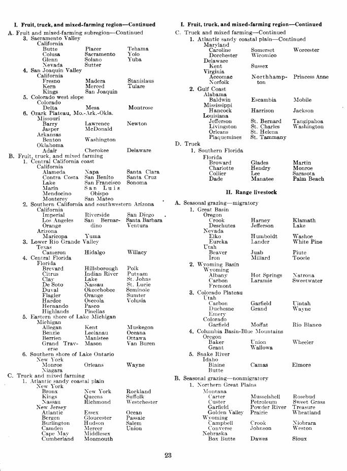
I. Fruit, truck, and mixed-farming region—Continued
A. Fruit and mixed-farming subregion—Continued 3. Sacramento Valley
California Butte Placer Tehama Colusa Sacramento Yolo Glenn Solano Yuba Nevada Sutter
4. San Joaquin Valley California
Fresno Madera Stanislaus Kern Merced Tulare Kings San Joaquin
5. Colorado west slope Colorado
Delta Mesa Montrose 6. Ozark Plateau, Mo.-Ark.-Okla.
Missouri Barry Lawrence Newton Jasper McDonald
Arkansas Benton Washington
Oklahoma Adair Cherokee Delaware
B. Fruit, truck, and mixed farming 1. Central California coast
California Alameda Xapa Santa Clara Contra Costa San Benito Santa Cruz Lake San Francisco Sonoma Marin San Luis Mendocino Obispo Monterey San Mateo
2. Southern California and southwest California
ern Arizona
Imperial Riverside San Diego Los Angeles San Bernar- Santa Barbara Orange dino Ventura
Arizona Maricopa Yuma
3. Lower Rio Grande Vallev Texas
Cameron Hidalgo Wülacy 4. Central Florida
Florida Brevard Hillsborough Polk Citrus Indian River Putnam Clay Lake St. Johns De Soto Nassau St. Lucie Duval Okeechobee Seminóle Plagier Orange Sumter Hardee Osceola Volusia Hernando Pasco Highlands Pinellas
5. Eastern shore of Lake Michigan Michigan
Allegan Kent Muskegon Benzie Leelanau Oceana Berrien Manistee Ottawa Grand Trav- Mason Van Buren
erse 6. Southern shore of Lake Ontario
New York Monroe Orleans Wayne X iagara
C. Truck and mixed farming 1. Atlantic sandy coastal plain
New York Bronx New York Rockland Kings Queens Suffolk Nassau Richmond Westchester
New Jersey Atlantic Essex Ocean Bergen Gloucester Passaic Burlington Hudson Salem Camden Mercer Union Cape May Middlesex Cumberland Monmouth
I. Fruit, truck, and mixed-farming region—Continued
C. Truck and mixed farming—Continued I. Atlantic sandy coastal plain—Continued
Marvland Caroline Dorchester
Delaware Kent
Virginia Accomac Norfolk
Gulf Coast Alabama
Baldwin Mississippi
Hancock Louisiana
Jefferson Livingston Orleans Plaquemines
Somerset Wicomico
Sussex
Northhamp- ton
Escambia
Harrison
St. Bernard St. Charles St. Helena St. Tammany
D. Truck 1. Southern Florida
Florida Broward Glades Charlotte Hendry Collier Lee Dade Manatee
XL Range livestock
A. Seasonal grazing—migratory
Worcester
Princess Anne
Mobile
Jackson
Tangipahoa Washington
Martin Monroe Sarasota Palm Beach
B.
1. Great Basin Oregon
Crook Harney Klamath Deschutes Jefferson Lake
Nevada Elko Humboldt Washoe Eureka Lander White Pine
Utah Beaver Juab Piute Iron Millard Tooele
2. Wyoming Basin \Vyoming
Albany Hot Springs Natrona Carbon Laramie Sweet water Fremont
3. Colorado Plateau Utah
Carbon Garfield L^intah Duchesne Grand Wayne Emery
Colorado Garfield Moffat Rio Blanco
4. Columbia Basin-Blue Mountains Oregon
Baker L^nion Wheeler Grant Wallowa
5. Snake River Idaho
Elaine Camas Elmore Butte
îas onal grazing—nonmigratory 1. Northern Great Plains
Montana Carter Musselshell Rosebud Custer Petroleum Sweet Grass Garfield Powder River Treasure Golden Valley Prairie Wheat land
Wyoming Campbell Crook Niobrara Converse Johnson West on
Nebraska Box Butte Dawes Sioux
23
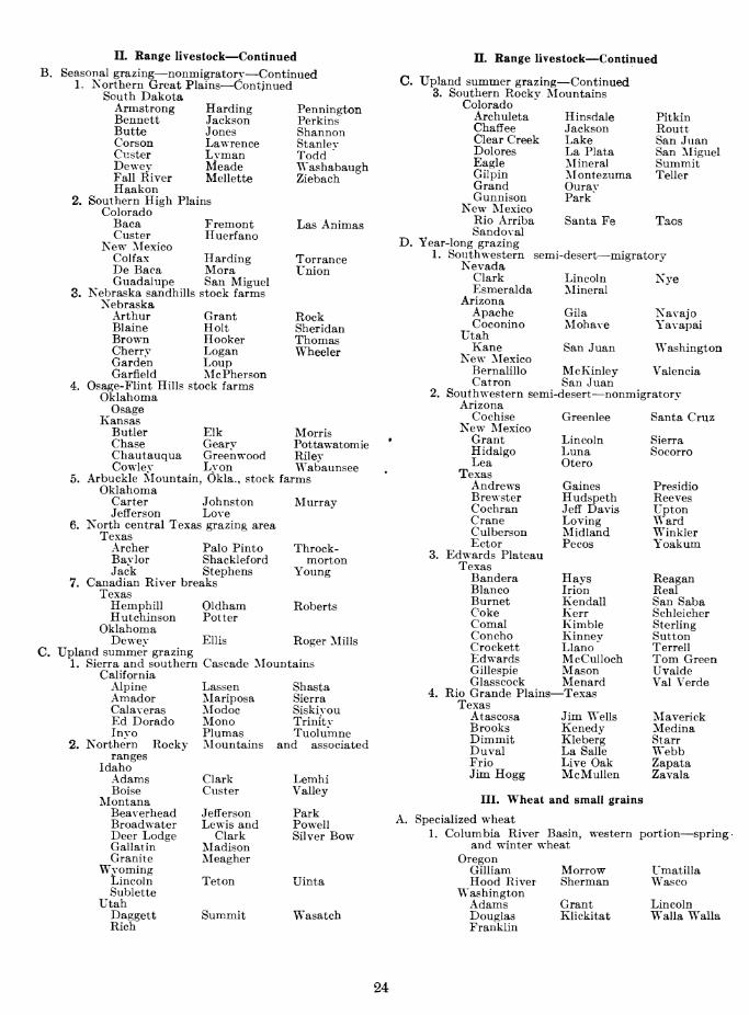
IL Range livestock—Continued
B. Seasonal grazing—nonmigratory—Continued 1. Northern Great Plains—Continued
South Dakota Armstrong Harding Pennington Bennett Jackson Perkins Butte Jones Shannon Corson Lawrence Stanley Custer Lyman Todd Dewey Meade Washabaugh Fall River Mellette Ziebach Haakon
2. Southern High Plains Colorado
Baca Fremont Las Animas Custer Huérfano
New Mexico Colfax Harding Torrance De Baca Mora Union Guadalupe San Miguel
3. Nebraska sandhills stock farms Nebraska
Arthur Grant Rock Blaine Holt Sheridan Brown Hooker Thomas Cherry Logan Wheeler Garden Loup Garfield McPherson
4. Osage-Flint Hills stock farms Oklahoma
Osage Kansas
Butler Elk Morris Chase Geary Pottawatomie Chautauqua Greenwood Riley Cowley Lyon Wabaunsee
5. Arbuckle Mountain, Okla., stock farms Oklahoma
Carter Johnston Murray Jefferson Love
6. North central Texas grazing area Texas
Archer Palo Pinto Throck- Baylor Shackleford morton Jack Stephens Young
7. Canadian River breaks Texas
Hemphill Oldham Roberts Hutchinson Potter
Oklahoma Dewey Ellis Roger Mills
C. Upland summer grazing 1. Sierra and southern Cascade Mountains
California Alpine Lassen Shasta Amador Mariposa Sierra Calaveras Modoc Siskiyou Ed Dorado Mono Trinity Inyo Plumas Tuolumne
2. Northern Rocky Mountains and associated ranges
Idaho Adams Clark Lemhi Boise Custer Valley
Montana Beaverhead Jefferson Park Broadwater Lewis and Powell Deer Lodge Clark Silver Bow Gallatin Madison Granite Meagher
Wyoming Lincoln Teton Uinta Sublette
Utah Daggett Summit Wasatch Rich
n. Range livestock—Continued
C. Upland summer grazing—Continued 3. Southern Rocky Mountains
Colorado Archuleta Hinsdale Pitkin Chaffee Jackson Routt Clear Creek Lake San Juan Dolores La Plata San Miguel Eagle Mineral Summit Gilpin Montezuma Teller Grand Ouray Gunnison Park
New Mexico Rio Arriba Santa Fe Taos Sandoval
D. Year-long grazing 1. Southwestern semi-desert—migratory
Nevada Clark Lincoln Nye Esmeralda Mineral
Arizona Apache Gila Navajo Coconino Mohave Yavapai
Utah Kane San Juan Washington
New Mexico Bernalillo McKinley Valencia Catron San Juan
2. Southwestern semi-desert—nonmigratory Arizona
Cochise Greenlee Santa Cruz New Mexico
► Grant Lincoln Sierra Hidalgo Luna Socorro Lea Otero
Texas Andrews Gaines Presidio Brewster Hudspeth Reeves Cochran Jeff Davis Upton Crane Loving Ward Culberson Midland Winkler Ector Pecos Yoakum
3. Edwards Plateau Texas
Bandera Hays Reagan Blanco Irion Real Burnet Kendall San Saba Coke Kerr Schleicher Comal Kimble Sterling Concho Kinney Sutton Crockett Llano Terrell Edwards McCulloch Tom Green Gillespie Mason Uvalde Glasscock Menard Val Verde
4. Rio Grande Plains—Texas Texas
Atascosa Jim Wells Maverick Brooks Kenedy Medina Dimmit Kleberg Starr Duval La Salle Webb Frio Live Oak Zapata Jim Hogg McMullen Zavala
III. Wheat and small grains
A. Specialized wheat 1. Columbia River Basin, western portion—spring-
and winter v rheat Oregon
Gilliam Morrow Umatilla Hood River Sherman Was CO
Washington Adams Grant Lincoln Douglas Klickitat Walla Walla Franklin
24
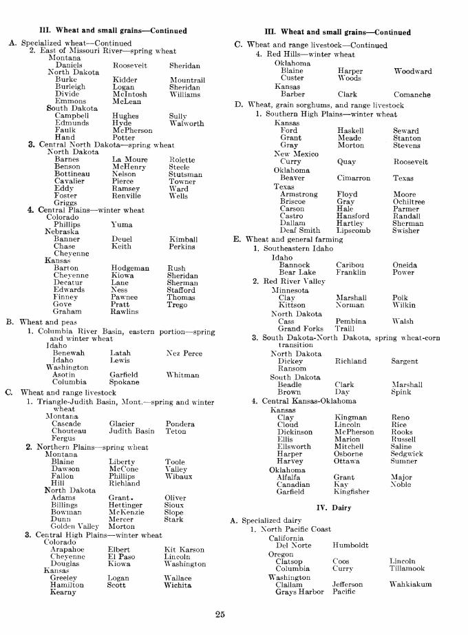
III. Wheat and small grains—Continued
A. Specialized wheat—Continued 2. East of Missouri River—spring wheat
Montana Daniels Roosevelt Sheridan
North Dakota Burke Kidder Mountrail Burleigh Logan Sheridan Divide Mclntosh Williams Eminons McLean
South Dakota Campbell Hughes Edmunds Hyde Faulk McPherson Hand Potter
3. Central North Dakota—spring wheat North Dakota
Barnes La Moure Benson McHenry Bottineau Nelson Cavalier Pierce Eddy Ramsey Foster Renville Griggs
4. Central Plains—winter wheat Colorado
Phillips Yuma Nebraska
Banner Deuel Chase Keith Cheyenne
Kansas Barton Hodgeman Cheyenne Kiowa Decatur Lane Edwards Ness Finney Pawnee Gove Pratt Graham Rawlins
rn. Wheat and small grains—Continued
C. Wheat and range livestock—Continued 4. Red Hills—winter wheat
Oklahoma Blaine Custer
Kansas Barber
Harper Woods
Woodward
D.
Sully Walworth
Rolette Steele Stutsman T owner Ward Wells
Kimball Perkins
Rush Sheridan Sherman Stafford Thomas Trego
Clark Comanche
Wheat, grain sorghums, and range livestock L Southern High Plains—winter wheat
Kansas Haskell Se ward Meade Stanton Morton Stevens
Ford Grant Gray
New Mexico Curry
Oklahoma Beaver
Texas Armstrong Briscoe Carson Castro Dallam Deaf Smith
E. Wheat and general farming
Quay
Cimarrón
Floyd Grav Hale Hansford Hartley Lipscomb
B. Wheat and peas 1. Columbia River Basin, eastern portion—spring
and winter wheat Idaho
Benewah Latah Nez Perce Idaho Lewis
Washington Asotin Garfield Whitman Columbia Spokane
Wheat and range livestock 1. Triangle-Judith Basin, Mont
wheat Montana
Cascade Glacier Chouteau Judith Basin Fergus
2. Northern Plains—spring wheat Montana
Blaine Liberty Dawson M c Cone Fallón Phillips Hill Richland
North Dakota Adams Grant. Billings Hettinger Bowman McKenzie Dunn Mercer Golden Valley Morton
3. Central High Plains—winter wheat Colorado
spring and winter
Pondera Tetón
Toóle Valley Wibaux
Oliver Sioux Slope Stark
Arapahoe Cheyenne Douglas
Kansas Greeley Hamilton Kearny
Elbert El Paso Kiowa
Logan Scott
Kit Karson Lincoln Washington
Wallace Wichita
1. Southeastern Idaho Idaho
Bannock Bear Lake
2. Red River Valley Minnesota
Clay Kittson
North Dakota Cass Grand Forks
3. South Dakota-North transition
North Dakota Dickey Ransom
South Dakota Beadle Brown
4. Central Kansas-Oklahoma Kansas
Clay Cloud Dickinson Ellis Ellsworth Harper Harvey
Oklahoma Alfalfa Grant Canadian Kay Garfield Kingfisher
IV. Dairy
A. Specialized dairy 1. North Pacific Coast
California Del Norte Humboldt
Oregon Clatsop Coos Columbia Curry
Washington Clallam Jefferson
Caribou Franklin
Marshall Norman
Pembina Train
Dakota,
Richland
Clark Dav
Kingman Lincoln McPherson Marion Mitchell Osborne Ottawa
Roosevelt
Texas
Moore Ochiltree Farmer Randall Sherman Swisher
Oneida Power
Polk Wilkin
Walsh
spring wheat-corn
Sargent
IM ar shall Spink
Reno Rice Rooks Russell Saline Sedgwick Sumner
Major Noble
Lincoln Tillamook
Wahkiakum Grays Harbor Pacific
25
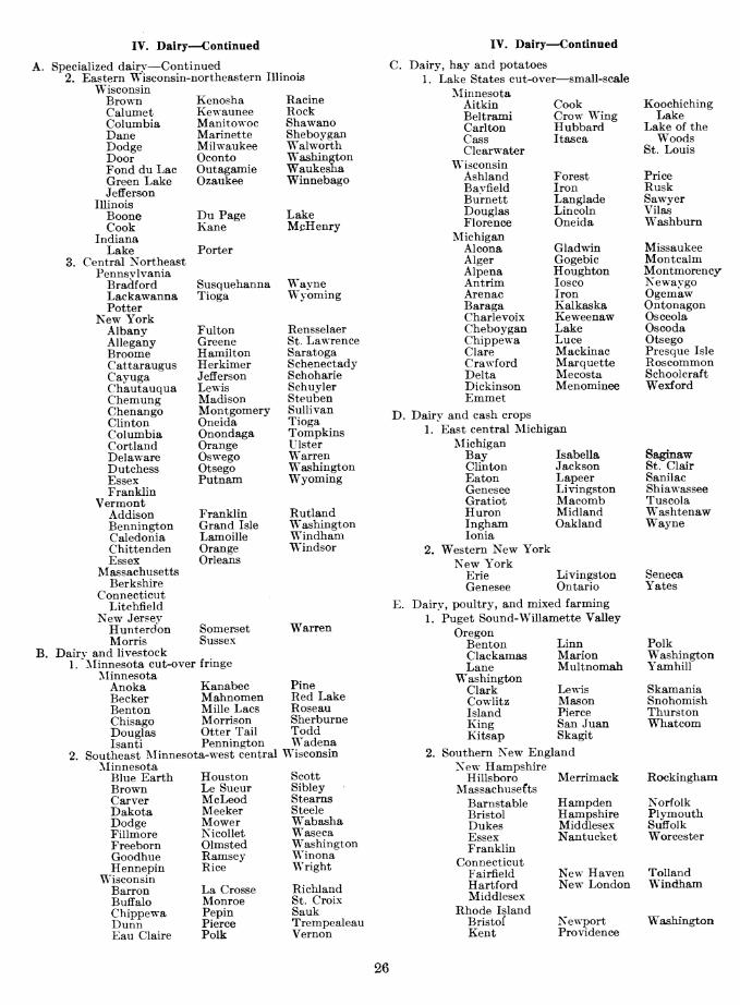
IV. Dairy—Continued
A. Specialized dairy—Continued 2. Eastern Wisconsin-northeastern Illinois
Wisconsin Brown Kenosha Racine Calumet Kewaunee Rock Columbia Manitowoc Shawano Dane Marinette Sheboygan Dodge Milwaukee Wal worth Door Oconto W^ashington Fond du Lac Outagamie Waukesha Green Lake Ozaukee Winnebago Jefferson
Illinois Boone Cook
Indiana Lake
3. Central Northeast Pennsylvania
Bradford Lackawanna Potter
New York Albany Allegany Broome Cattaraugus Cayuga Chautauqua Chemung Chenango Clinton Columbia Cortland Delaware Dutchess Essex Franklin
Vermont Addison Bennington Caledonia Chittenden Essex
Massachusetts Berkshire
Connecticut Litchfield
New Jersey Hunterdon Morris
B. Dairy and livestock L '^ Minnesota cut-over fringe
Minnesota Anoka Kanabec Becker Mahnomen Benton Mille Lacs Chisago Morrison Douglas Otter Tail Isanti Pennington
2. Southeast Minnesota-west central Wisconsin Minnesota
IV. Dairy—Continued
C. Dairy, hay and potatoes 1. Lake States cut-over—small-scale
Minnesota Aitkin Cook Beltrami Crow Wing Carlton Hubbard Cass I tasca Clearwater
Du Page Kane
Porter
Susquehanna Tioga
Fulton Greene Hamilton Herkimer Jefferson Lewis Madison Montgomery Oneida Onondaga Orange Oswego Otsego Putnam
Franklin Grand Isle Lamoille Orange Orleans
Somerset Sussex
Lake McHenry
Wayne W^yoming
Rensselaer St. Lawrence Saratoga Schenectady Schoharie Schuyler Steuben Sullivan Tioga Tompkins Ulster Warren Washington Wyoming
Rutland W'ashington Windham W^indsor
Warren
Pine Red Lake Roseau Sherburne Todd Wadena
Wisconsin Ashland Bayfield Burnett Douglas Florence
Michigan Alcona Alger Alpena Antrim Arenac Baraga Charlevoix Cheboygan Chippewa Clare Crawford Delta Dickinson Emmet
Forest Iron Langlade Lincoln Oneida
Glad win Gogebic Houghton losco Iron Kalkaska Keweenaw Lake Luce Mackinac Marquette Mecosta Menominee
D. Dairy and cash crops L East central Michigan
Michigan Bay Isabella Clinton Jackson Eaton Lapeer Genesee Livingston Gratiot Macomb Huron Midland Ingham Oakland Ionia
2. Western New York New York
Erie Genesee
Livingston Ontario
E. Dairy, poultry, and mixed farming L Puget Sound-Willamette Valley
Oregon Benton Linn Clackamas Marion Lane Mult nom ah
Washington Clark Lewis Cowlitz Mason Island Pierce King San Juan Kitsap Skagit
Blue Earth Brown Carver Dakota Dodge Fillmore Freeborn Goodhue Hennepin
Wisconsin Barron Buffalo Chippewa Dunn Eau Claire
Houston Le Sueur McLeod Meeker Mower Ni collet Olmsted Ramsey Rice
La Crosse Monroe Pepin Pierce Polk
Scott Sibley Stearns Steele Wabasha Waseca Washington Winona Wright
Richland St. Croix Sauk Trempealeau Vernon
2. Southern New England New Hampshire
Hillsboro Massachusefts
Barnstable Bristol Dukes Essex Franklin
Hampden Hampshire Middlesex Nantucket
Koochiching Lake
Lake of the Woods
St. Louis
Price Rusk Sawyer Vilas Washburn
Missaukee Montcalm Montmorency Ne way go Ogemaw Ontonagon Osceola Oscoda Otsego Presque Isle Roscommon Schoolcraft Wexford
Saginaw St. Clair Sanilac Shiawassee Tuscola Washtenaw Wayne
Seneca Yates
Polk Washington Yamhill
Skamania Snohomish Thurston Whatcom
Merrimack Rockingham
Connecticut Fairfield Hartford Middlesex
Rhode Island Bristoi Kent
New Haven New London
Newport Providence
Norfolk Plymouth Suffolk Worcester
ToUand Windham
Washington
26
IV. Dairy—Continued
F. Dairy and general farming 1. Central Wisconsin
Wisconsin Adams Marathon Waupaca Clark Marquette Waushara Jackson Portage Wood Juneau Taylor
2. Central Pennsylvania Pennsylvania
BedJFord Juniata Perry Blair Mifiiin SchuVlkill Centre Montour Snyder Columbia Northumber- Union Fulton land Huntingdon
Maryland Alieganv
3. Northern Piedmont Pennsylvania
Adams Dauphin Lehigh Berks Delaware Montgomery Bucks Franklin Northamptoi] Chester Lancaster Philadelphia Cumberland Lebanon York
Maryland Baltimore Harford Queen Annes Carroll Howard Talbot Cecil Kent Washington Frederick Montgomery
Delaware New Castle
Virginia Arlington Loudoun Rappahan- Culpeper Madison nock Fairfax Orange Spotsvlvania Fauquier Prince Stafford Greene William
4. Lake Erie border Ohio
Ashland Holmes Portage Ashtabula Huron Richland Columbiana Lake Stark Cuyahoga Lorain Summit Erie Mahoning Trumbull Geauga Medina Wayne
Pennsylvania Crawford Lawrence Warren Erie Mercer
5. Northern New England—small scale New Hampshire
Belknap Coos Strafford Carroll Grafton Sullivan Cheshire
Maine Androscoggin Knox Sagadahoc Cumberland Lincoln Somerset Franklin Oxford Waldo Hancock Penobscot Washington Kennebec Pisca taquis York
6. Allegheny Plateau, Pa.—small scale Pennsylvania
Allegheny Clinton McKean Armstrong Elk Monroe Beaver Fayette Pike Butler Forest Somerset Cambria Greene Sullivan Cameron Indiana Venango Carbon Jefferson Washington Clarion Luzerne Westmore- Clearfield Lycoming land
Maryland Garrett
West Virginia Preston
V. Feed grains and livestock (Corn Belt)
A. Cattle feeding and hogs
1. Central Missouri River Valley Kansas
Atchison Brown
Nebraska Burt Cass Cedar Cuming Dakota Dixon Dodge
South Dakota Clay Lake Lincoln
Iowa Audubon Buena Vista Carroll Cass Cherokee Crawford Fremont Harrison
Missouri Andrew Atchison Buchanan Carroll Clay
Doniphan Jackson
Douglas Gage Johnson Lancaster Nemaha Otoe Pawnee
Minnehaha Moody Turner
Ida Lvon Mills Monona Montgomery O'Brien Page
Clinton Holt Jackson Lafav^ette
Eastern Iowa-western Illinois Iowa
Benton Cedar Clinton Des Moines Grundy Henry Iowa
Illinois Bureau Fulton Hancock Henderson Henry
Jasper Johnson Keokuk Linn Louisa Mahaska
Knox McDonough Marshall Mercer
B. Cash corn, oats, and soybeans 1. Central Iowa
Boone Calhoun Dallas Franklin Greene
2. East central Illinois Illinois
Cass Champaign Coles De Witt Douglas Edgar Ford Grundy Iroquois
Indiana Benton Warren
Hamilton Hardin Humboldt Pocahontas
Kankakee Kendall La Salle Livingston Logan McLean Macon Mason
Nemaha
Richardson Sarpy Saunders Thurston Washington Wayne
L'nion Yankton
Plymouth Pottawat-
tamie Sac Shelby Sioux Woodbury
Nodaway Platte Ray Saline
Marshall Muscatine Poweshiek Scott Tama Washington
Peoria Putnam Stark Warren
Polk Story Webster Wright
Menard Moultrie Piatt Sangamon Tazewell Vermilion Will Woodford
White
27
V. Feed grains and livestock (Corn Belt)—Continued V. Feed grains and livestock (Corn Belt)—Continued C. Hogs and soft winter wheat F. Livestock and cash grain
1. Northwestern corn-livestock tran; 1. Central Indiana-southwestern Ohio Indiana sition
Bartholomew Hancock Putnam South Dakota Boone Hendricks ■ Randolph Aurora Brule Jerauld Carroll Henry Rush Buffalo Gregory Tripp Cass Howard Shelby Nebraska Clinton Johnson Tippecanoe Boyd Keya Paha Decatur Madison Tipton 2. Southwestern corn -hard winter w heat transition Delaware Marion Union Kansas Fayette Miami Vermillion Jewell Phillips Smith Fountain Montgomery Wabash Norton Grant Parke Wayne Nebraska Hamilton Adams Furnas Lincoln
Ohio Clay Gosper Nuckolls Butler Fayette Pick away Dundy Harlan Phelps
Redwillow Champaign Franklin Preble Fillmore Hayes Clark Greene Ross Franklin Hitchcock Thaver Clinton Darke Delaware
Madison Miami Monteomerv
Shelby Warren
Frontier Kearney 3. Western Corn Belt fringe
Webster
2. Wabash and lower ' Ohio River Vallevs Kansas Indiana Marshall Republic Washington
Clay Morgan Sullivan Nebraska Daviess Posey Vanderburgh Antelope Hamilton Platte Gibson Owen V igo Boone Howard Polk Greene Spencer Warrick Buffalo Jefferson Saline Knox Butler Knox Seward
Illinois Colfax Madison Sherman Clark Gallatin Wabash Custer Merrick St anton Crawford Lawrence White Dawson Nance Vallev Edwards Saline Greeley Pierce York'
Kentucky Hall Daviess McLean Webster South Dakota Henderson Union Bon Homme Douglas McCook
D. Livestock, dairv, sovbeans, and cash grain Charles Mix Hanson Miner 1. Northwestern Ohio-northeastern I ndiana Davison Hutchinson Sanborn
Indiana 4. Northwestern Corn Belt fringe Adams Fulton Marshall Minnesota Allen Huntington Noble Big Stone Pope
Redwood Swift
Blackford Jay Steuben Chippewa Traverse De Kalb Elkhart
Kosciusko Lagrange
Wells Whitley
Grant Kandiyohi
Renville Stevens
Yellow Medi- cine
Michigan Lac qui Parle South Dakota Branch Lenawee Monroe
Hillsdale Ohio
Brookings Grant Kingsbury Codington DPHPI
Hamlin Roberts Allen Logan Sandusky Auglaize Crawford
Lucas Marion
Seneca I^nion 5. Northern Iowa-southwestern Minnesota
Defiance Mercer Van Wert Minnesota Fulton Ottawa Williams Cottonwood Lyon Pipestone Hancock Paulding Wood Faribault Martin Rock Hardin Putnam Wyandot Jackson Murray Wat on wan Henry Lincoln Nobles
E. Hogs and dairy Iowa 1. Northeastern low a-northwestern Illinois-south- Clay Hancock Osceola
western Wisconsin Dickinson Kossuth Palo Alto Iowa Emmet
Allamakee Clayton Jackson G. Livestock, cash erain an d dairv Black Hawk Bremer
Delaware Dubuque
Jones Mitchell 1. Western Missouri-eastern Kansas
Buchanan Favette Winnebago Kansas Butler Fl¿yd Winneshiek Allen Franklin Miami Cerro Gordo Howard Worth Anderson Jefferson Osage Chickasaw Bourbon Johnson Shawnee
Wisconsin Coffey Leaven wort h Woodson Crawford Green Lafayette Douglas Linn Wyandot te Grant Iowa Missouri
Illinois Barton Cooper Pet t is Carroll Lee Stephenson Bates Dade St. Clair De Kalb Ogle Whiteside Cass Henry Vernon Jo Daviess Rock Island Winnebago Cedar Johnson
28
V. Feed grains and livestock (Corn Belt)—Continued
H. Livestock and pasture 1. Southern Iowa-northern Missouri-west central
illlinois Missouri
Adair Audrain Boone Caldwell Cal la way Chariton Clark Daviess De Kalb Gentry Grundy
Illinois Adams Brown Calhoun Christian Greene
Iowa Adair Adams Appanoose Clarke Davis Decatur Guthrie
Harrison Howard Knox Lewis Lincoln Linn Livingston Macon Marion Mercer Monroe
Jersey Macoupin Montgomery Morgan
Montgomery Pike Putnam Rails Randolph Schuyler Scotland Shelby Sullivan Worth
Pike Schuvler Scott Shelby
VI. General farming—Continued
D. Livestock and special crops—irrigated—Continued 4. Upper Arkansas Valley
Colorado Bent Otero Pueblo Crowley Prowers
E. Livestock and cash grain 1. Grand prairie of Texas
Texas Bosque Dentón Mills Cooke Hamilton Tarrant Coryell Lampasas
2. Southeast Kansas—northeast* Oklahoma Kansas
Cherokee Crawford
Oklahoma Craig Mayes Xowata
Labette Montgomery
Ottawa Rogers
Xeosho Wilson
Tulsa Washington
Jefferson Lee Lucas Madison Marion Monroe Ringgold
2. Noilhwestern Indiana-southwestern Michigan Indiana
Jasper Newton La Porte Pulaski
Michigan Barry Cass Calhoun Kalamazoo
VI. General farming
Taylor Union Van Buren Wapello Warren Wavne
St. Joseph Starke
St. Joseph
A. Dairv and livestock feeding—irrigated 1, Western Nevada
Nevada Churchill Lyon Pershing Douglas Ormsby Storey
B. Dairy, hay, and sugar beets—irrigated 1. Lower Snake Riv er
Idaho Ada Gem Payette Canyon Owyhee Washington
Oregon Malheur
C. Dairy and range livestock—small-scale 1. Northern Rocky Mountains cut-over
Idaho Bonner Clearwater Shoshone Boundary Kootenai
Montana Flat head Mineral Sanders Lincoln
Washington Ferry Pend Oreille Stevens
D. Livestock and special crops—irrigated 1. Central Utah and southeastern Idaho
Utah Box Elder Morgan Sevier Cache Salt Lake Utah Davis Sanpete Weber
2. Western Montana Montana
Lake Missoula Ravalli 3. San Luis Valley
Colorado Alamosa Costilla Saguache Conejos Rio Grande
F. Livestock, truck, and cotton—small-scale 1. Southern Ozark and Ouachita Mountains
Arkansas Baxter Boone Carroll Fulton Garland Independence Izard
Oklahoma Atoka Coal
Missouri Ozark
G. Dairy, livestock, and poultry 1. St. Louis milkshed
Madison Marion Montgomery Newton Perrv Pike"^ Polk
Latimer Pittsburg
Stone
Missouri Jefferson
Illinois Bond Clinton Effingham
St. Charles
Fayette Madison Monroe
2. Ozark IVIountains and border Missouri
Benton Greene Bollinger Hickory Camden Howell Cape Girar- Iron
deau Laclede Carter Madison Christian Maries Cole Miller Crawford Moniteau Dallas Morgan Dent Oregon Douglas Osage Franklin Perry Gasconade Phelps
lUinois Alexander Johnson Hardin Massac Jackson Pope
3. Southern Illinois gray lands Illinois
Clay Jasper Cumberland Jefferson Franklin Marion Hamilton Perry
Randolph Saline Scott Searcy Sharp Stone
Pushmataha
Taney
St. Louis
Randolph St. Clair Washington
Polk Pulaski Reynolds Ripley St. Francois Ste. Gene-
viève Shannon Texas Warren Washington Wayne Webster Wright
Pulaski Union
Richland Wayne Williamson
29
VI. General farming—Continued
H. Livestock and tobacco
VI. General farming—Continued
J. Livestock and dairy—Continued
J.
1. Knobs and coal fit úás, Indiana-Kei Qtucky 2. Great Appalachian Valley Indiana Virginia
Brown Jackson Orange Alleghany Giles Rockingham Clark Jefferson Perry Augusta Grayson Russell Crawford Jennings Pike Bath Highland Scott Dubois Lawrence Ripley Bland Lee Shenandoah Floyd Martin Scott Botetourt Montgomery Smyth Franklin Monroe Washington Carroll Page Tazewell Harrison Clarke Pulaski Warren
Kentucky Craig Roanoke Washington Adair Green Menifee Floyd Rockbridge Wythe Allen* Hancock Metcalf Frederick Breckinridge Hardin Monroe West Virginia Bullitt Hart Muhlenberg Berkeley Jefferson Pendleton Butler Hopkins Ohio Grant Mineral Pocahontas Casey Jefferson Powell Greenbrier Monroe Randolph Clinton Larue Pulaski Hampshire Morgan Tucker Crittenden Lewis Rockcastle Hardy Cumberland Lincoln Rowan Tennessee Edmonson Livingston Russell Anderson Hamilton Monroe Estill Lyon Taylor Blount Hancock Rhea Grayson Meade Wayne Campbell Hawkins Roane
Claiborne Jefferson Sevier 2. Highland nm of Tennessee Cocke Knox Sullivan
Tennessee Grainger London L^nion Clav Humphreys Putnam Greene Meigs Washington Coffee Lewis Stewart H amblen Dickson Franklin
M aeon Overton
Van Buren Warren K. Livestock, fruit, and tobacco—small-scale
Grundy Perrv Wavne 1. Appalachian Mountains Hickman Pickett White West Virginia Houston B arbour Kanawha Putnam
3. Upper Ohio River Valley and hills Boone Braxton
Lewis Lincoln
Raleigh Ritchie
indiana Cabell Logan Roane Dearborn Ohio Switzerland Calhoun McDowell Summers
Ohio Clay Marion Taylor Adams Harrison Morgan Doddridge Mason Upshur Athens Highland Morrow Fayette Mercer Wayne Belmont Hocking Muskingum Gilmer Mingo Webster Brown Jackson Nable Harrison Monongalia Wirt Carroll Jefferson Perry Jackson Nicholas Wyoming Clermont Knox Pike Kentucky Coshocton Lawrence Scioto Bell Jackson McCreary Fairfield Licking Tuscarawas Bovd Johnson Magofliin Gallia Meigs Vinton Breathitt Knott Martin Guernsey Monroe Washington Carter Knox Morgan Hamilton Clav Laurel Owsley
West Virginia Elliott LawTence Perrv Brooke Ohio Wetzel Floyd Lee Pike^ Hancock Pleasants Wood Greenup Leslie Whitley Marshall Tvler Harlan Letcher Wolfe
4. Central Virginia Piedmont Virginia
Buchanan Dickenson Wise Virginia North Carolina
Albemarle Campbell Goochland Alleghany Graham Mitchell Amelia Chesterfield Louisa Ashe H ay wood Swain Amherst Cumberland Nelson A ver y Henderson Transylvania Appomattox Dinwiddie Nottoway Buncombe Jackson Watauga Bedford Edward Powhatan Cherokee Macon Yancey Buckingham Fluvanna Prince Clay Madison
livestock and dairy Tennessee Bledsoe Johnson Scott
1. Central basin of Tennessee Carter Marion Sequatchie Tennessee Cumberland Morgan Unicoi
Bedford Lincoln Smith Fentress Cannon Marshall Sumner Georgia Davidson Maury Trousdale Dawson Lumpkin Towns De Kalb Moore Williamson Fannin Pickens L^nion Giles Rutherford Wilson Gilmer Rabun White Jackson Habersham
30
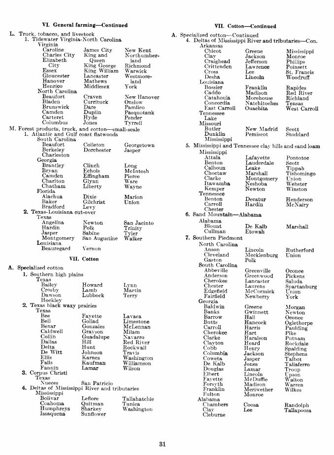
VI. General farming—Continued
L. Truck, tobacco, and livestock 1. Tidewater Virginia-North Carolina
Virginia Caroline James City New Kent Charles City King and Northumber- Ehzabeth Queen land
City King George Richmond Essex King William Warwick Gloucester Lancaster Westmore- Hanover Mathews land Henrico Middlesex York
North Carolina Beaufort Craven New Hanover Bladen Currituck Onslow Brunswick Dare Pamlico Camden Duplin Pasquotank Carteret Hyde Pender Columbus Jones Tvrrell
M. Forest products, truck, and cotton—small-scale 1. Atlantic and Gulf coast flatwoods
South Carolina Beaufort Colleton Georgetown Berkeley Dorchester Jasper Charleston
Georgia Brantley Clinch Long Bryan Echols Mclntosh Camden Effingham Pierce Charlton Glynn Ware Chatham Liberty Wayne
Florida Alachua Dixie Marion Baker Gilchrist Union Bradford Lew
2. Texas-Louisiana cut-over Texas
Angelina Newton San Jacinto Hardin Polk Trinity Jasper Sabine Tyler Montgomery SaQ Augustine Walker
Louisiana Beauregard Vernon
VII. . Cotton
A. Specialized cotton 1. Southern high plains
Texas Bailey Howard Lynn Crosby Lamb Martin Daws on Lubbock Terry Hocklev
2. Texas black waxy prairies Texas
Bee Fayette Lavaca Bell Goliad Limestone Bexar Gonzales McLennan Caldwell Grayson Milam Collin Guadalupe Navarro Dallas Hill Red River Delta Hunt Rockwall De Witt Johnson Travis Ellis Karnes Washington Falls Kaufman Williamson Fannin Lamar W^ilson
3. Corpus Christi Texas
Nueces San Patricio 4. Deltas of Mississippi River and tributaries
Mississippi Bolivar Leflore Tallahatchie Coahoma Quitman Tunica Humphreys Sharkey W^ashington Issaquena Sunflower
VII. Cotton—Continued
A. Specialized cotton—Continued 4. Deltas of Mississippi River and tributaries—Con.
Arkansas Chicot Clay Craighead Crittenden Cross Desha
Louisiana Bossier Caddo Catahoula Concordia East Carroll
Tennessee Lake
Missouri Butler Dunklin Mississippi
5. Mississippi and Tennessee cla^' hills and sand loam Mississippi
Lafayette Lauderdale Leake Marshall Montgomery Neshoba Ne\\iion
Greene Jackson Jefferson Lawrence Lee Lincoln
Franklin Madison Morehouse Natchitoches Guachi ta
New Madrid Pemiscot
Attala Benton Calhoun Choctaw Clarke Itawamba Kemper
Tennessee Benton Decatur Carroll Hardin Chester
6. Sand Mountain—Alabama Alabama
Blount De Kalb Cullman Etowah
7. Southern Piedmont
Mississippi Monroe Phillips Poinsett St, Francis Woodruff
Rapides Red River Richland Tensas West Carroll
Scott Stoddard
Pontotoc Scott Tippah Tishomingo Union Webster Winston
North Carolina An son Cleveland Gaston
South Carolina Abbeville Anderson Cherokee Chester Edgefield Fairfield
Georgia Baldwin Banks Barrow Butts Carroll Cherokee Clarke Clavton Cobb Columbia Co wet a De Kalb Douglas Elbert Fayette Forsyth Franklin Fulton
Alabama Chambers Clay Cleburne
Lincoln Mecklenburg Polk
Greenville Greenwood Lancaster Laurens McCormick Newberry
Greene Gwinnett Hall Hancock Harris Hart Haralson Heard Henry Jackson Jasper Jones Lamar Lincoln McDufíie Madison Meriwether Monroe
Coosa Lee
Henderson McNairy
Marshall
Rutherford Union
Oconee Pickens Saluda Spartanburg Union York
Morgan Newton Oconee Oglethorpe Paulding Pike Putnam Rockdale Spalding Stephens Talbot Taliaferro Tro up Upson Walton Warren Wllkes
Randolph Tallapoosa
31
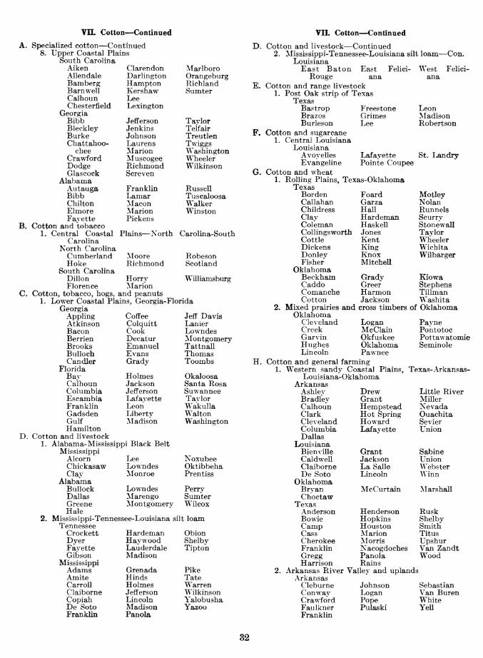
Vn. Cotton—Continued Vn. Cotton—Continued
A. Specialized cotton—Continued D. Cotton and livestock—Continued 8. Upper Coastal Plains 2. Mississippi-Tennessee-Louisiana silt loam—Con.
South Carolina Louisiana Aiken Clarendon Marlboro East Baton East Felici- West Felici- Allen dale Darlington Orangeburg Rouge ana ana Bamberg Hampton Richland E. Cotton and ranere livestock Barn well Calhoun
Kershaw Lee
Sumter L Post Oak strip of Texas
Chesterfield Lexington Bastrop Freestone Leon Georgia Brazos Grimes Madison
Bibb Jefferson Tavlor Burleson Lee Robertson Bleckley Burke Chattahoo-
chee Crawford Dodge
Jenkins Johnson Laurens Marion Muscogee Richmond
Telfair Treutlen Twiggs Washington Wheeler Wilkinson
F. Cotton and sugarcane 1. Central Louisiana
Louisiana Avoyelles Evangeline
T^afavette Pointe Coupée
St. Landry
Glascock Screven G. Cotton and wheat Alabama I. Rolling Plains, Texas-Oklahoma
Autauga Franklin Russell Texas Bibb Lamar Tuscaloosa Borden Foard Motley Chilton Macon Walker Callahan Garza Nolan Elmore Marion Winston Childress Hall Runnels Fayette Pickens Clay Hardeman Scurry
B. Cotton and tobacco Coleman Haskeil Stonewall 1. Central Coastal Plains—North Carolina-South Coll ings worth Jones Tavlor
Carolina Cottle Kent Wheeler North Carolina Dickens King Wichita
Cumberland Moore Robeson Donley Knox Wilbarger Hoke Richmond Scotland Fisher MitcheU
South Carolina Oklahoma Dillon Horry Williamsburg Beckham Grady Kiowa Florence Marion Caddo Greer Stephens
C. Cotton, tobacco, hogs, and peanuts Comanche Harmon Tillman 1. Lower Coastal Plains, Georgia-Florida Cotton Jackson Washita
Georgia 2. Mixed prairies and . cross timbers of Oklahoma Appling Coffee Jeff Davis Oklahoma Atkinson Colquitt Lanier Cleveland Logan Payne Bacon Cook Lowndes Creek McClain Pontotoc Berrien Decatur Montgomery Gar vin Okfuskee Pottawatomie Brooks Emanuel Tattnall Hughes Oklahoma Seminóle Bulloch Evans Thomas Lincoln Pawnee Candler Grady Toombs H. Cotton and general farming
Florida 1. Western sandv Coastal Plains. Texas-Arkansas- Bay Holmes Okaloosa Louisiana-Oklahoma Calhoun Jackson Santa Rosa Arkansas Columbia Jefferson Suwannee Ashley Drew Little River Escambia Lafayette Tavlor Bradley Grant Miller Franklin Leon Wakulla Calhoun Hempstead Nevada Gadsden Liberty Walton Clark Hot Spring Ouachita Gulf Madison Washington Cleveland Howard Sevier Hamilton Columbia Lafayette Union
D. Cotton and livestock Dallas 1. Alabama-Mississippi Black Belt Louisiana
Mississippi Bienville Grant Sabine Alcorn Lee Noxubee Caldwell Jackson Union Chickasaw Lowndes Oktibbeha Claiborne La Salle Webster Clay Monroe Prentiss De Soto Lincoln Winn
Alabama Oklahoma Bullock Lowndes Perry Bryan M c Curtain MarshaU Dallas Marengo Sumter Choctaw Greene Montgomery Wilcox Texas Hale Anderson Henderson Rusk
2. Mississippi-Tennessee-Louisiana silt loam Bowie Hopkins Shelby Tennessee Camp Houston Smith
Crockett Hardeman Obion Cass Marion Titus Dver Haywood Shelby Cherokee Morris Upshur Fayette Lau der dale Tipton Franklin Nacogdoches Van Zandt Gibson Madison Gregg Panola Wood
Mississippi Harrison Rains Adams Grenada Pike 2. Arkansas River Valley and uplands Amite Hinds Täte Arkansas CarroU Holmes Warren Cleburne Johnson Sebastian Claiborne Jefferson Wilkinson Con way Logan Van Buren Copiah Lincoln Yalobusha Crawford Pope White De Soto Madison Yazoo Faulkner Pulaski YeU Fra.nklin Panola Franklin
32
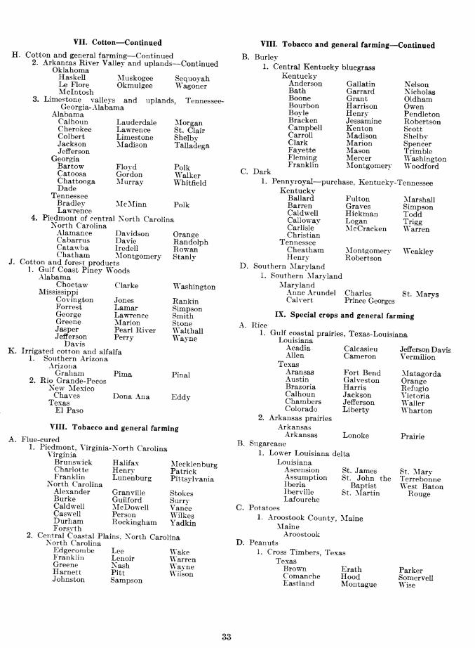
VIL Cotton—Continued
H. Cotton and general farming—Continued 2. Arkansas River Valley and uplands—Continued
Oklahoma Haskell IVIuskogee Sequoyah Le Flore Okmulgee Wagoner Mclntosh
3. Limestone valleys and uplands, Tennessee- Georgia-Alabama
Alabama Calhoun Cherokee Colbert Jackson Jefferson
Georgia Bartow Catoosa Chattooga Dade
Tennessee Bradley Lawrence
Piedmont of central North Carolina North Carolina
Lauderdale Lawrence Limestone Madison
Floyd Gordon iVIurraj^
McMi
Morgan St. Clair Shelby Talladega
Polk Walker Whitfield
Polk
Alamance Cabarrus Catawba Chatham
J. Cotton and forest products 1. Gulf Coast Piney Woods
Alabama Choctaw
Mississippi Covington Forrest George Greene Jasper Jefferson
Davis K. Irrigated cotton and alfalfa
1. Southern Arizona Arizona
Graham Pima 2. Rio Grande-Pecos
New Mexico Chaves Dona Ana
Texas El Paso
Davidson Davie Iredell Montgomery
Clarke
Jones Lamar LawTence Marion Pearl River Perry
Orange Randolph Rowan Stanlv
Washington
Rankin Simpson Smith Stone Walthall Wavne
Final
A. Rice 1.
VIII. Tobacco and general farming—Continued
Nelson Nicholas Oldham Owen Pendleton Robertson Scott Shelby Spencer Trimble Washington Woodford
-Tennessee
Marshall Simpson Todd Trigg W arren
Weaklev
Southern Maryland Maryland
Anne Arundel Charles St. Marys Calvert Prince Georges
IX. Special crops and general farming
Gulf coastal prairies, Texas-Louisiana Louisiana
B. Burley 1. Central Kentucky bluegrass
Kentucky Anderson Gallatin Bath Garrard Boone Grant Bourbon Harrison Boyle Henry Bracken Jessamine Campbell Kenton Carroll Madison Clark Marion Fayette Mason Fleming Mercer Franklin
C. Dark Montgomery
1. Pennyroyal—purchase, Kentucky Kentucky
Ballard Fulton Barren Graves Caldwell Hickman Galloway Logan Carlisle McCracken Christian
Tennessee Cheatham Montgomery Henry Robertson
D. Southern Maryland
Eddy
VIII. Tobacco and general farming
A. Flue-cured 1. Piedmont, Virginia-North Carolina
Virginia Brunswick Halifax Charlotte Henry Franklin Lunenburg
North Carolina Alexander
Calcasieu Cameron
Fort Bend Galveston Harris Jackson Jefferson Liberty
Lonoke
Mecklenburg Patrick Pittsylvania
Burke Caldwell Caswell Durham Forsyth
2. Central Coastal Plains, North Carolina North Carolina
Granville Guilford McDowell Person Rockingham
Stokes Surry Vance Wilkes Yadkin
Edgecombe Franklin Greene Harnett Johnston
Lee Lenoir Nash Pitt Sampson
Wake Warren Wayne Wilson
Acadia Allen
Texas Aransas Austin Brazoria Calhoun Chambers Colorado
2. Arkansas prairies Arkansas
Arkansas B. Sugarcane
1. Lower Louisiana delta Louisiana
Ascension St. James Assumption St. John the Iberia Baptist Iberville St. Martin Lafourche
C. Potatoes 1. Aroostook County, Maine
Maine Aroostook
D. Peanuts 1. Cross Timbers, Texas
Texas Brown Erath Comanche Hood Eastland Montague
Jefferson Davis Vermilion
Matagorda Orange Refugio Victoria Waller Wharton
Prairie
St. Mary Terrebonne West Baton
Rouge
Parker Somervell Wise
33
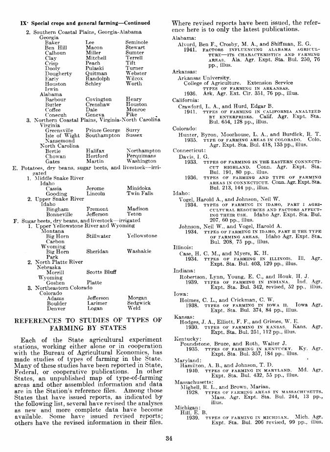
IX* Special crops and general farming—Continued
2. Southern Coastal Plains, Georgia-Alabama Georgia
Baker Lee Seminóle Ben Hill Macon Stewart Calhoun Miller Sumter Clav Mitchell Terrell Crisp Peach Tift Dooly Pulaski Turner Dougherty Quitman Webster Early Randolph Wilcox Houston Schley Worth Irwin
Alabama Barbour Covington Henry Butler Crenshaw Houston Coffee Dale Monroe Conecuh Geneva Pike
3. Northern Coastal Plains, Virginia-North Carolina Virginia
Greensville Prince George Surry Isle of Wight Southampton Sussex Nansemond
North Carolina Bertie Halifax Northampton Chowan Hertford Perquimans Gates Martin Washington
E. Potatoes, dry beans, sugar beets, and livestock—irri- gated
1. Middle Snake River Idaho
Cassia Jerome Minidoka Gooding Lincoln Twin Falls
2. Upper Snake River Idaho
Bingham Fremont Madison Bonneville Jefferson Teton
F. Sugar beets, dry beans, and livestock—irrigated 1. Upper Yellowstone River and Wyoming
Montana Big Horn Still water Yellowstone Carbon
Wyoming Big Horn Sheridan Washakie Park
2. North Platte River Nebraska
Morrill Scotts Bluff Wyoming
" Goshen Platte 3. Northeastern Colorado
Colorado Adams Jefferson Morgan Boulder Larimer Sedgwick Denver Logan Weld
REFERENCES TO STUDIES OF TYPES OF FARMING BY STATES
Each of the State agricultural experiment stations, working either alone or in cooperation with the Bureau of Agricultural Economics, has made studies of types of farming in the State. Many of these studies have been reported in State, Federal, or cooperative publications. In other States, an unpublished map of type-of-farming areas and other assembled information and data are in the Station's reference files. Among those States that have issued reports, as indicated by the following list, several have revised the analyses as new and more complete data have become available. Some have issued revised reports; others have the revised information in their files.
Where revised reports have been issued, the refer- ence here is to only the latest publications. Alabama:
Alvord, Ben F., Crosby, M. A., and Shiffman, E. G. 1941. FACTORS INFLUENCING ALABAMA AGRICUL-
TURE ITS CHARACTERISTICS AND FARMING AREAS. Ala. Agr. Expt. Sta. Bui. 250, 76 pp., illus.
Arkansas: Arkansas University.
College of Agriculture. Extension Service TYPES OF FARMING IN ARKANSAS.
1936. Ark. Agr. Ext. Cir. 351, 76 pp., illus. California:
Crawford, L. A., and Hurd, Edgar B. 1941. TYPES OF FARMING IN CALIFORNIA ANALYZED
BY ENTERPRISES. Calif. Agr. Expt. Sta. Bui. 654, 128 pp., illus.
Colorado: Hunter, Byron, Moorhouse, L. A., and Burdick, R. T.
1935. TYPE OF FARMING AREAS IN COLORADO. Colo. Agr. Expt. Sta. Bui. 418, 135 pp., illus.
Connecticut: Davis, I. G.
1933. TYPES OF FARMING IN THE EASTERN CONNECTI- CUT HIGHLAND. Couu. Agr. Expt. Sta. Bul. 191, 80 pp., illus.
1936. TYPES OF FARMING AND TYPE OF FARMING AREAS IN CONNECTICUT. Conn. Agr. Expt. Sta. Bui. 213, 144 pp., illus.
Idaho: Vogel, Harold A., and Johnson, Neil W.
1934. TYPES OF FARMING IN IDAHO, PART I AGRI- CULTL'RAL RESOURCES AND FACTORS AFFECT- ING THEIR USE. Idaho Agr. Expt. Sta. Bui. 207, 60 pp., illus.
Johnson, Neil W., and Vogel, Harold A. 1934. TYPES OF FARMING IN IDAHO, PART II THE TYPE
OF FARMING AREAS. Idaho Agr. Expt. Sta. Bui. 208, 75 pp., illus.
Illinois: Case, H. C. M., and Myers, K. H.
1934. TYPES OF FARMING IN ILLINOIS. 111. Agr. Expt. Sta. Bui. 403, 129 pp., illus.
Indiana: Robertson, Lynn, Young, E. C, and Houk, H. J.
1939. TYPES OF FARMING IN INDIANA. lud. Agr. Expt. Sta. Bui. 342, revised, 52 pp., illus.
Iowa: Holmes, C. L., and Crickman, C. W.
1938. TYPES OF FARMING IN IOWA II. lowa Agr. Expt. Sta. Bui. 374, 84 pp., illus.
Hodges, J. A., Elliott, F. F., and Grimes, W. E. 1930. TYPES OF FARMING IN KANSAS. KaUS. Agr.
Expt. Sta. Bui. 251, 112 pp., illus. Kentucky :
Poundstone, Bruce, and Roth, Walter J. 1935. TYPES OF FARMING IN KENTUCKY. Ky. Agr.
Expt. Sta. Bui. 357, 184 pp., illus. Maryland :
Hamilton, A. B., and Johnson, T. D. 1940 TYPES OF FARMING IN MARYLAND. Md. Agr.
Expt. Sta. Bui. 432, 55 pp., illus. Massachusetts:
Mighell, R. L., and Brown, Marian. 1928. TYPES OF FARMING AREAS IN MASSACHUSETTS.
Mass. Agr. Expt. Sta. Bui. 244, 13 pp., illus.
Michigan : Hill, E. B.
1939. TYPES OF FARMING IN MICHIGAN. Mich. Agr. Expt. Sta. Bui. 206 revised, 99 pp., illus.
34
Minnesota:
Engene, Selmer A., and Pond, George A. 1940. AGRICULTURAL PRODUCTION AND TYPES OF
FARMING IN MINNESOTA. Minn. Agr. Expt. Sta. Bui. 347, 70 pp., illus.
1940. STATISTICAL SUPPLEMENT TO AGRICULTURAL PRODUCTION AND TYPES OF FARMING IN MINNESOTA. Minn. Agr. Expt. Sta. Sup- plement to Bui. 347, 24 pp.
Mississippi:
Crosby, M. A. 1940. TYPES OF FARMING IN MISSISSIPPI. BUF. AgP.
Econ., 126 pp., ulus. [Processed.] Missouri:
Hammar, Conrad H., Roth, Walter J., and Johnson, O. R.
1938. TYPES OF FARMING IN MISSOURI. Mo. Agr. Expt. Sta. Res. Bui. 284, 100 pp., illus.
Montana:
Oilman, Virgil A.
1934. TYPES OF FARMING IN SOUTHEASTERN MON- TANA. Mont. Agr. Expt. Sta. Bui. 287, 61 pp., illus.
Johnson, Neil W., and Saunderson, M. H.
1936. TYPES OF FARMING IN MONTANA. PART I PHYSICAL ENVIRONMENT AND ECONOMIC FACTORS AFFECTING MONTANA AGRICULTURE. Mont. Agr. Expt. Sta. Bui. 328, 79 pp., illus.
1939. FARM ADJUSTMENTS IN MONTANA. STUDY OF AREA VII : ITS PAST, PRESENT AND FUTLRE. Mont. Agr. Expt. Sta. Bui. 367, 59 pp., illus.
Nebraska : Hedges, Harold, and Elliott, F. F.
1930. TYPES OF FARMING IN NEBRASKA. NebP. AgT. Expt. Sta. Bui. 244, 76 pp., illus.
Garey, L. F.
1936. FACTORS DETERMINING TYPE-OF-FARMING AREAS IN NEBRASKA. Nebí. AgF. Expt. Sta. Bui. 299, 32 pp., illus.
New Hampshire:
Grinnell, Harold C.
1937. TYPE OF FARMING AREAS IN NEW HAMPSHIRE. N. H. Agr. Expt. Sta. Cir. 53, 14 pp., illus.
New Mexico: Hunter, Byron, Cockerill, P. W., and Pingrey, H. B.
1939. TYPE OF FARMING AND RANCHING AREAS IN NEW MEXICO. PART I. N. Mex. AgF. Expt. Sta. Bui. 261, 68 pp., illus.
New York:
Beck, R. S.
1938. TYPES OF FARMING IN NEW YORK. N. Y. (Cornell) Agr. Expt. Sta. Bui. 704, 71 pp., illus.
North Dakota:
Willard, Rex E., and Fuller, O. M.
1927. TYPE-OF-FARMING AREAS IN NORTH DAKOTA. N. Dak. Agr. Expt. Sta. Bui. 212, 274 pp., illus.
Elliott, F. F., Tapp, Jesse W., and Willard, Rex E. 1928. TYPES OF FARMING IN NORTH DAKOTA. U. S.
Dept. Agr. Tech. Bui. 102, 54 pp., illus.
Ohio: Sitterley, J. H., and Falconer, J. I.
1933. TYPE-OF-FARMING AREAS IN OHIO. Ohio Agr. Expt. Sta. Bui. 56, 20 pp., illus. [Processed.]
Ohio Committee on Production Adjustments in Ohio Agriculture.
1944. A POSTWAR CROP AND LIVESTOCK PATTERN FOR OHIO UNDER CONDITIONS OF FULL EMPLOY- MENT. Ohio Agr. Expt. Sta. [Processed.] Map of Agricultural Areas of Ohio on page 5.
Oklahoma: Ellsworth, J. O., and Elliott, F. F.
1929. TYPES OF FARMING IN OKLAHOMA. Okla. AgT. Expt. Sta. Bui. 181, 81 pp., ulus.
Oregon: Scudder, H. D., and Hurd, E. B.
1935. GRAPHIC SUMMARY OF AGRICULTURE AND LAND USE IN OREGON. Oreg. Agr. Expt. Sta. Cir. 114, 39 pp., illus.
Pennsylvania: Wrigley, Paul I.
1946. TYPES OF FARMING IN PENNSYLVANIA. Pa. Agr. Expt. Sta. Bui. 479, 56 pp., illus.
South Dakota: Rogers, R. H., and Elliott, F. F.
1929. TYPES OF FARMING IN SOUTH DAKOTA. S. Dak. Agr. Expt. Sta. Bui. 238, 71 pp., illus.
Tennessee : Luebke,*B. H., Atkins, S. W., Allred, C. E., and Roth,
W. J. 1939. TYPES OF FARMING IN TENNESSEE. Tenn. AgF.
Expt. sta. Bui. 169, 94 pp., illus. Texas :
Bonnen, C. A. and Thibodeaux, B. H. 1937. A DESCRIPTION OF THE AGRICULTURE AND
TYPE-OF-FARMING AREAS IN TEXAS. TeX. Agr. Expt. sta. Bui. 554, 91 pp., illus.
Utah: Clawson, Marion, Fuhriman, Walter U., Blanch, George
T., and Thomas, W. Preston. 1936. TYPES OF FARMING IN UTAH. Utah AgT. Expt.
sta. Bui. 275, 98 pp., illus. Washington:
Willard, Rex E., and Johnson, Neil W. 1933. PRESENT LAND USE WASHINGTON TYPES OF
FARMING SERIES, PART I. Wash. AgT. Expt. Sta. Bui. 288, 40 pp., illus.
Johnson, Neil W., and Willard, Rex E. 1934. TRENDS IN AGRICULTURE IN WASHINGTON 1900
TO 1930 TYPES OF FARMING SERIES, PART II. Wash. Agr. Expt. Sta. Bui. 300, 45 pp., ulus.
1934. NATURE AND DISTRIBL^TION OF TYPES OF FARMING IN WASHINGTON. TYPES OF FARM- ING SERIES, PART III. Wash. Agr. Expt. Sta. Bui. 301, 64 pp., illus.
West Virginia: Arment rout, W. W., and Johnson, T. D.
1939. TYPES OF FARMING IN WEST VIRGINIA. W. Va. Agr. Expt. Sta. Bui. 292, 77 pp., illus.
Wisconsin: McNall, P. E., and Roth, W. J.
1935. FORCES AFFECTING WISCONSIN AGRICULTURE WITH RESULTING TYPES OF FARMING. Wis. Agr. Expt. Sta. Res. Bui. 131, 40 pp., illus.
Wyoming: Hunter, Byron, Pearson, H. W., and Vass, A. F.
1938. TYPES OF FARMING AND RANCHING AREAS IN WYOMING. Wyo. Agr. Expt. Sta. Bui. 228, 180 pp., illus.
35 U s GOVERNMENT PRINTING OFFICE" 1950


![All about different types of farming & agriculture [File Size 3095kb]](https://img.pdfslide.net/doc/110x75/54667fb1b4af9f833e8b4f2d/all-about-different-types-of-farming-agriculture-file-size-3095kb.jpg)