Embed Size (px)
Citation preview
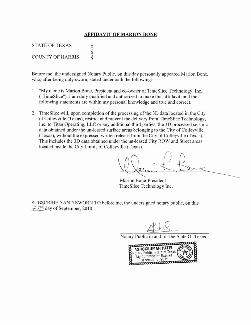
Geo-Physical Permit Request for Colleyville, Texas
November, 2010
Timeslice Technology, Inc. 209 Western Hills Trail
Granbury, TX 76049
(254)592-5513
Vickie Brown
TIMESLICE TECHNOLOGY, INC.
TITAN CAMRA SEISMIC PERMIT
s
TABLE OF CONTENTS
1. Application for Seismic
2. Contractors
3. Insurance
4. Affidavit
5. Seismic Procedure Book
6. Traffic Plan
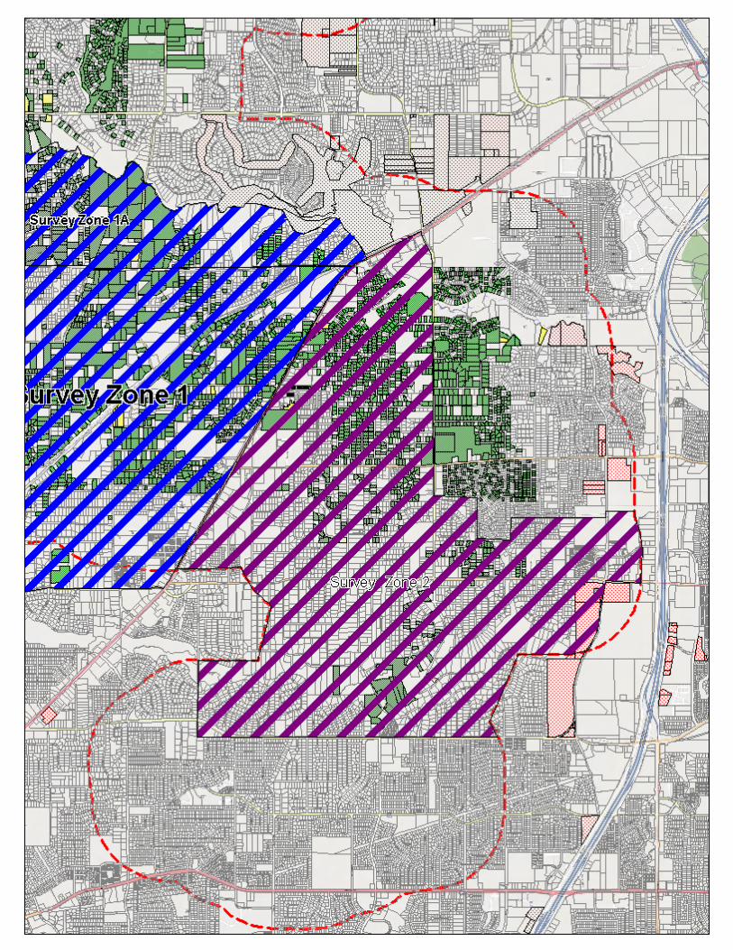
7. Map of Project

TimeSlice Technology, Inc. 209 Western Hills Trail
Granbury, Texas 76049 Office (817) 573-6758
Fax (817)573-6759 Cell (254) 592-5513
City of Colleyville 100 Main Street Colleyville, Texas 76034 Attention: Ron Ruthven October 20, 2010 Dear Mr. Ruthven, Titan Oil and Gas will be conducting a geophysical survey in Colleyville, Texas in the near future. TimeSlice Technology, Inc. is under contract with Titan and will be acting as agent during the course of the geophysical survey. We would like to begin this project no sooner than November 10, 2010. We expect this project to last between 10 to 14 days weather permitting. We would like to request permission to use right of ways, which would be represented on enclosed map. We will do our best to utilize bridges and culverts when possible to cross the roadways. I would ask at this time, you grant permission for this project. TimeSlice Technology, Inc. will keep you informed or our progress, as you deem necessary. Respectfully Submitted, Vickie Ratliff Brown TimeSlice Technology, Inc. Approved By:______________________________ Date: _______________________________
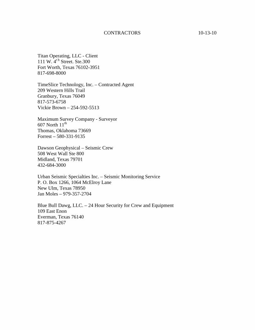
CONTRACTORS 10-13-10 Titan Operating, LLC - Client 111 W. 4t h Street. Ste.300 Fort Worth, Texas 76102-3951 817-698-8000 TimeSlice Technology, Inc. – Contracted Agent 209 Western Hills Trail Granbury, Texas 76049 817-573-6758 Vickie Brown – 254-592-5513 Maximum Survey Company - Surveyor 607 North 11th Thomas, Oklahoma 73669 Forrest – 580-331-9135 Dawson Geophysical – Seismic Crew 508 West Wall Ste 800 Midland, Texas 79701 432-684-3000 Urban Seismic Specialties Inc. – Seismic Monitoring Service P. O. Box 1266, 1064 McElroy Lane New Ulm, Texas 78950 Jan Moles – 979-357-2704 Blue Bull Dawg, LLC. – 24 Hour Security for Crew and Equipment 109 East Enon Everman, Texas 76140 817-875-4267

Conduct Of A Geophysical Survey
Time Slice Technology, Inc. 1
By TimeSlice Technology, Inc.
August 1, 2004

Conduct Of A Geophysical Survey
Time Slice Technology, Inc. 2
DESCRIPTION A 3D Seismic Survey consists of lines of receiver points (geophones) and lines of source (energy) points
laid out in an overlapping matrix patterns within the same geographical area. Once the receivers are
deployed and the source points made ready; they are recorded in a systematic sequence and the data
stored on magnetic tape. Each source point is recorded individually. There are no multiple source point
recordings. A survey can range in size from as small as 1 square mile up to 100 + square miles. Figure 1
__________________________________________________________________________________
____________________________________________________________________________________ Blue = Receiver Points Red = Source Points
Typical 3D Diagonal Layout
Conduct Of A Geophysical Survey
Time Slice Technology, Inc. 3
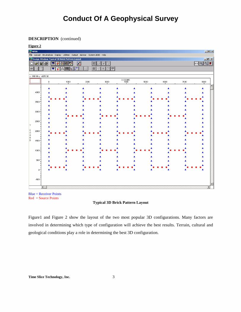
DESCRIPTION (continued) Figure 2
Blue = Receiver Points Red = Source Points
Typical 3D Brick Pattern Layout
Figure1 and Figure 2 show the layout of the two most popular 3D configurations. Many factors are
involved in determining which type of configuration will achieve the best results. Terrain, cultural and
geological conditions play a role in determining the best 3D configuration.

Conduct Of A Geophysical Survey
Time Slice Technology, Inc. 4
PURPOSE
3D Technology is the newest tool in the search for hydrocarbons. It provides a three dimensional picture
of the subsurface which is a great improvement over the older 2D seismic method. The clarity of the
subsurface events are enhanced and therefore provide a much more accurate picture than the older
seismic methods.
PERMIT PHASE This is the first of five phases in a 3D seismic survey. The first step in this phase is to identify the
landowners inside the project area and obtain their permission to access the property. Permit letters are
sent to each surface landowner advising them that a geophysical survey is about to begin and requesting
their cooperation. Also, oil companies with leases inside the project area must be identified and their
leasehold minerals permitted.
In the State of Texas the surface rights are subservient to the mineral rights; thereby giving the mineral
owner and/or the mineral lessee the right of access for the purpose of mineral exploration, including the
right to conduct geophysical surveys. If the surface owner also owns the minerals, and they are not
leased, then he has the right to deny access to the property.
The time involved in completing this phase can take from one or two weeks to as long as several months.
SURVEY PHASE Source & Receiver Point Layout
The matrix pattern for both the receivers and source points has been pre-determined during the planning
stage. The distance between receiver and source lines can vary depending on the targeted subsurface
zone. Normally these distances vary from say, 660 feet to as high as 1320 feet. The distance between
individual receiver and source points along each line will vary from project to project, but is always a
multiple of the distance between the lines. As seen in Figure 1, the matrix pattern for the source and
receiver lines fall in opposite directions from each other.

Conduct Of A Geophysical Survey
Time Slice Technology, Inc. 5
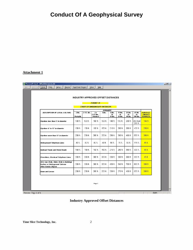
Source Point Offsets
In areas with heavy culture, source point offsets can become the rule rather than the exception. No source
point is ever placed closer than 300 feet to any building, water well, septic system, pond, levee or any
other structure that might sustain damage. Depending on the size and complexity of the structure, the
source point may be offset further than 300 feet (See attached Offset Chart).
Receiver Point Offsets
In order to achieve the desired result from the 3D Survey, it is very important that the receivers are
placed as close as possible to the desired location. They are passive instruments and pose no threat to any
structures or land. Normally there are 6 receivers per location arranged in a circular pattern (refer to the
attachments for a picture of a single receiver).
Survey Vehicles The largest vehicle utilized during the survey phase is a full size pickup truck. The smallest vehicle will
be a 4-wheel All-Terrain-Vehicle (ATV). In cases where even these vehicles may cause damage, the
survey crews will walk the property and hand carry their instruments. We do ask permission to cut brush
and native trees (i.e. mesquite, scrub oak or cedar) two inches or less in diameter. However, no tree
cutting takes place without the landowner’s knowledge and consent.
Start of Field Operations The start of the survey phase signals the beginning of field operations. Normally this happens when the
permitting phase is almost complete. Prior notice is always given to the landowners who request it before
entering the property.
Conduct Of A Geophysical Survey
Time Slice Technology, Inc. 6
ENERGY SOURCE The energy source can be either seismic explosives or vibroseis. The Railroad Commission and The
Texas Natural Resource Conservation Commission tightly enforce the rules and regulations for using
seismic explosives. In recent years it has become difficult to obtain permission to drill shot holes deeper
than 20 feet. Since shot holes at this depth are usually above the weathering, the data quality suffers.
Therefore the vibroseis has become the energy source of choice in the last few years.
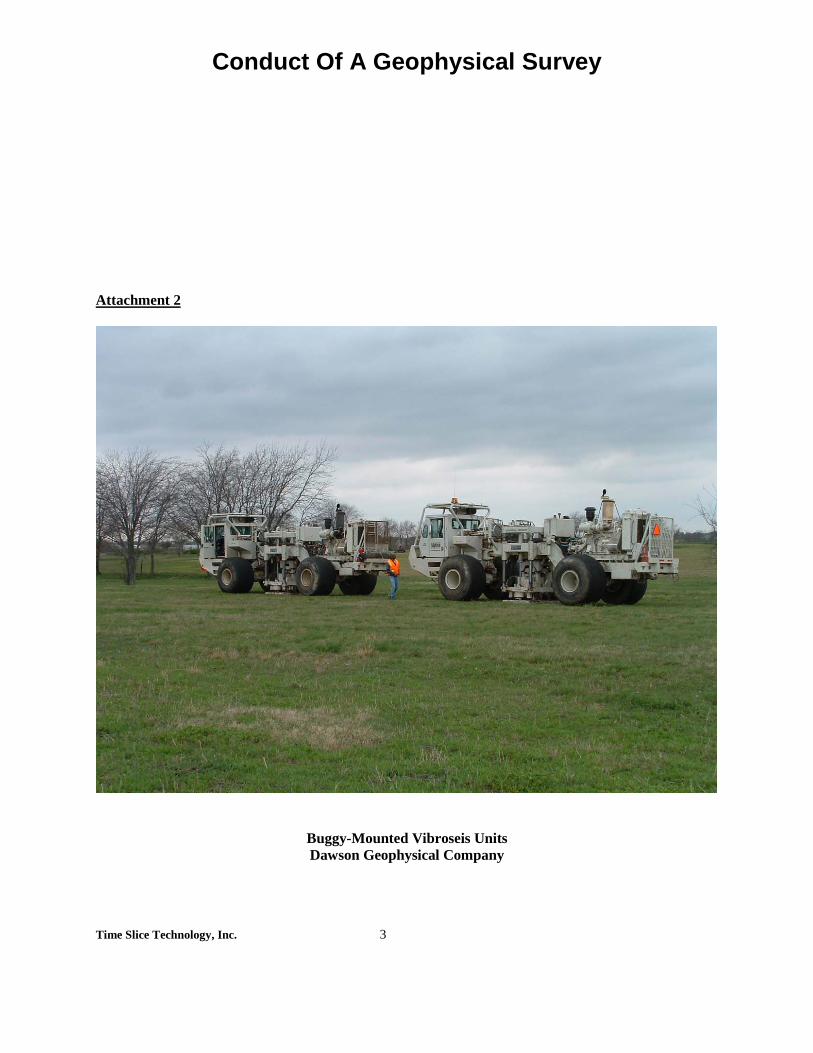
Vibroseis Units
The vibroseis units are mounted on large articulated buggy’s that use either track or balloon tires. The
balloon tires are ideally suited to operations in an open range environment since the pounds per square
inch (psi) exerted on the ground are significantly less than that of the track tire. Track tires are used in
rocky terrain where more traction is needed.
As an energy source the vibroseis has several advantages over other sources. Firstly, the data acquired
by vibroseis has been of a much higher quality in recent years. Secondly, it is more environmentally
friendly in that it lessens the amount of travel required across the property (See attached picture of a
vibroseis unit).
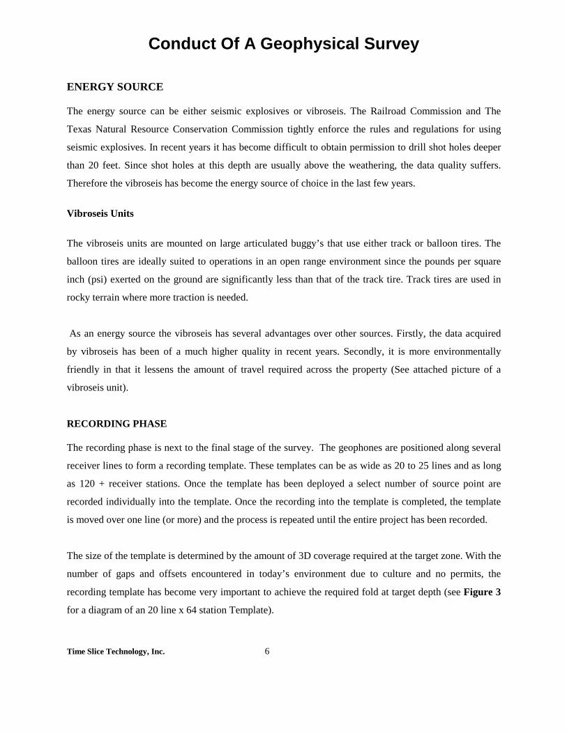
RECORDING PHASE The recording phase is next to the final stage of the survey. The geophones are positioned along several
receiver lines to form a recording template. These templates can be as wide as 20 to 25 lines and as long
as 120 + receiver stations. Once the template has been deployed a select number of source point are
recorded individually into the template. Once the recording into the template is completed, the template
is moved over one line (or more) and the process is repeated until the entire project has been recorded.
The size of the template is determined by the amount of 3D coverage required at the target zone. With the
number of gaps and offsets encountered in today’s environment due to culture and no permits, the
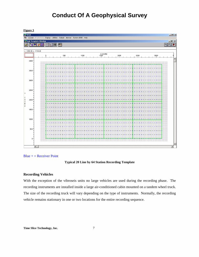
recording template has become very important to achieve the required fold at target depth (see Figure 3
for a diagram of an 20 line x 64 station Template).
Conduct Of A Geophysical Survey
Time Slice Technology, Inc. 7
Figure 3
Blue + = Receiver Point
Typical 20 Line by 64 Station Recording Template
Recording Vehicles
With the exception of the vibroseis units no large vehicles are used during the recording phase. The
recording instruments are installed inside a large air-conditioned cabin mounted on a tandem wheel truck.
The size of the recording truck will vary depending on the type of instruments. Normally, the recording
vehicle remains stationary in one or two locations for the entire recording sequence.

Conduct Of A Geophysical Survey
Time Slice Technology, Inc. 8
Receivers & Cables
The receivers and cables are deployed and retrieved by pickup trucks and 4-wheel ATVs in normal
terrain. . In heavily wooded areas they may be hand carried into position. In areas where a larger vehicle
will not make tracks, larger vehicles (4x6) will be utilized to lay out cables and geophones.
CLEANUP
The final stage of the data acquisition process is the cleanup. This starts as soon as the first source point
is recorded and continues until such time as all the flagging, wooden stakes and debris is picked up over
the entire survey area. The entire prospect is policed to ensure that everything has been picked up and the
area cleared.
During the recording phase records are kept of any damage that occurs. Each landowner where damage
has occurred is contacted and arrangements are made to repair the damage to the landowner’s
satisfaction. Crop damage is compensated for at fair market value.
GENERAL COMMENTS The length of time equipment will be on any individual property will vary depending on the type of
energy source, the size of the prospect, the weather and the trouble shooting requirements. The average
length of time on any one property is about 14 days. The number of times the property will have to be
accessed will vary accordingly.
In all phases of the operation caution is exercised to ensure that no property is accessed during adverse
weather conditions. Today’s geophysical crews are trained not to cut fences; leave gates open or engage
in any activity that can cause harm to the property. In the mid 1980s’ there were over 800 geophysical
crews active in the United States. Today, there are less 20 active crews. The end result is better
performance today versus yesterday.
Seismic crews today must work with the landowner in every way possible to prevent any undue
interruption to his activities on the property. 3D Seismic has the flexibility to achieve this goal and still
acquire good seismic data.

Conduct Of A Geophysical Survey
Time Slice Technology, Inc. 1
Attachments
Conduct Of A Geophysical Survey
Time Slice Technology, Inc. 2
Attachment 1
Industry Approved Offset Distances
Conduct Of A Geophysical Survey
Time Slice Technology, Inc. 3
Attachment 2
Buggy-Mounted Vibroseis Units Dawson Geophysical Company

Conduct Of A Geophysical Survey
Time Slice Technology, Inc. 4
Attachment 3
Buggy-Mounted Drilling Rig Mercer Seismic Drilling

Conduct Of A Geophysical Survey
Time Slice Technology, Inc. 5
Attachment 4
Remote Seismic Recorder (RSR) & Battery Box Dawson Geophysical Company

Conduct Of A Geophysical Survey
Time Slice Technology, Inc. 6
Attachment 5
Seismic Receiver (Geophone) Dawson Geophysical Company

CONDUCT OF A GEOPHYSICAL SURVEY
Frequently Asked Questions And Answers
TimeSlice Technology, Inc. 1
WHAT IS A 3D GEOPHYSICAL SURVEY? 3D Geophysical Survey is the newest tool used in the search for hydrocarbons. It consists of a network of receiver lines spaced an equal distance apart; with sensors (geophones) spaced at set intervals along each receiver line. Another network of source lines are spaced in between the receiver lines with source points spaced along each source line at set intervals. The energy created by the activation of the source points is recorded at each receiver point to give a three dimensional picture of the subsurface. The improved resolution and higher density of the seismic data makes the detection of hydrocarbons far more accurate than the older 2D seismic methods. WHEN WILL THE SURVEY START AND FINISH? The permitting phase of the survey is underway at this time. Field Operations will start in the next two to three weeks and will last for approximately 45 days, bad weather time excepted. The different phases of the entire survey are: Permitting Phase Survey Phase Drilling Phase (not applicable in this case) Recording Phase Cleanup Phase WHEN WILL YOU PAY? Payment will be made at the beginning of the survey phase. WHAT ABOUT MY WATER WELL? The incidence of water well damage by either shot point or vibroseis is very rare. The elapsed time between the source points being surveyed and recorded is long enough to allow the landowner to report any source points that are set too close to any objects. We will meet with you and rectify the problem before any damage can occur.

CONDUCT OF A GEOPHYSICAL SURVEY
Frequently Asked Questions And Answers
TimeSlice Technology, Inc. 2
WILL YOU BE CUTTING ANY TREES? WHAT ABOUT MY FENCES AND GATES? We do ask permission to cut brush and native trees (mesquite or scrub oak) two inches or less in diameter. If you instruct us not to cut any trees, none will be cut. We do not cut fences. If any fences are damaged they will be repaired. We do not cut locks on gates and we always leave the gate as we found it. If it was open, we leave it open. If closed, we leave it closed. We do ask permission to place our own locks on the gates for the duration of the survey. These locks will be removed when the survey is complete. HOW WILL THIS AFFECT MY LIVESTOCK? Cattle, sheep and other farm animals coexist fairly well with seismic surveys. We limit the amount of flagging that we put out which solves the problem associated with the cattle eating the flagging. Any damages to our geophones and cables by the farm animals are at our expense. When we are on property where horses are present, we use extreme caution not to disturb them in any way. In these circumstances, we work very closely with the landowner to prevent injury to the horses. WILL YOU BE BRINGING LARGE EQUIPMENT ON MY LAND? The largest piece of equipment that will access your land is either a drill truck or a vibroseis unit. The drills that we use are the exact same drills that you use to drill your water wells. The vibroseis units are heavy and large vehicles. In areas where the terrain is not firm enough to use the truck-mounted drills, we use buggy-mounted drills with large balloon type tires. These drill units can traverse soft areas without creating huge ruts. They are articulated and can move easily in tight quarters, such as some wooded areas. They are about the same size as a large farm tractor. The vibroseis units are mounted on articulated buggies, which allows for good mobility in tight quarters. As with the drill units we use either track or balloon tires depending on the terrain. The good news with the vibroseis units is that they reduce the amount of travel over the source lines when compared against the drill units.

CONDUCT OF A GEOPHYSICAL SURVEY
Frequently Asked Questions And Answers
TimeSlice Technology, Inc. 3
WILL YOU BE BRINGING LARGE EQUIPMENT ON MY LAND? (Continued) Other than the drill and vibroseis units, the largest vehicles that will access your property is a ¾ ton pickup truck. The smallest is a 4-wheel ATV. WHAT ABOUT MY CROPS? Unfortunately, some times it is necessary for us to place receiver and source lines through crops. Crop damage, or even potential crop damage, is negotiated prior to any work being done on the property. When such an instance occurs, we will contain our traverse through the crop to a 12-foot swath. We will then compute the amount of acreage contained inside the track and pay for that portion of the crop. The basis for that calculation will be the market value of that crop times the average yield. WHO DOES THIS BENEFIT? WHAT’S IN IT FOR ME? This is a difficult question to answer because it depends on each individual’s point of view. There is no question that our society and way of life is directly dependent on hydrocarbons. Without a sufficient supply, we will not be able to continue our way of life. The USA is the largest user of hydrocarbons in the world and whether we supply our own or purchase from abroad, is the key question. There is a minority that believes we should purchase from abroad. The majority believes that, in the interest of national security and to avoid the possibility of periodic shortages, we should produce as many hydrocarbons as possible here at home.
End

Traffic Plan

Traffic Plan
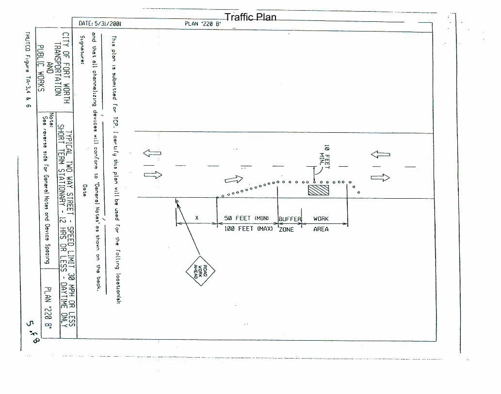
Traffic Plan

Traffic Plan

Traffic Plan
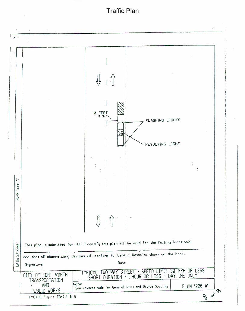
Traffic Plan