Embed Size (px)
Citation preview

KSCE Journal of Civil Engineering (2011) 15(8):1435-1441DOI 10.1007/s12205-011-1401-8
− 1435 −
www.springer.com/12205
Transportation Engineering
Geocoding Vehicle Collisions on Korean Expressways Based onPostmile Referencing
Shin Hyoung Park*, John M. Bigham**, Seung-Young Kho***,Seungmo Kang****, and Dong-Kyu Kim*****
Received November 23, 2010/Accepted February 17, 2011
···································································································································································································································
Abstract
Geocoding is the process of assigning latitude and longitude coordinates to data that contain spatial information. Geocodedrecords of motor vehicle collisions are an invaluable resource for injury prevention researchers. The objective of this study is toapply the postmile referencing system for geocoding collisions on Korean expressways and summarize the methodology andresults with comparative research efforts in the USA. A street network provided by Korea Expressway Corporation was cleanedand calibrated using ArcGIS and a customized Visual Basic for Applications (VBA) tool. Geocoding via postmile referencing wasdetermined to develop the most appropriate methodology for Korean expressways. A database of expressway collisions from 2003to 2008 was geocoded, and 24,854 out of 24,879 (99.9%) collisions were successfully matched to the street network. This studyestablished an effective methodology for geocoding collisions on Korean expressways. Future research will benefit from thedevelopment of a street network that can be updated over time to incorporate newly constructed roads. The methods for streetnetwork cleaning and error checking and the use of linear referencing to geocode collisions are easily transferable to highwaynetworks in other countries. The geocoded database of expressway collisions can be used for numerous traffic safety improvementprograms and help reduce fatalities.Keywords: geocoding, expressway collisions, linear referencing, postmile markers, traffic safety
···································································································································································································································
1. Introduction
Geocoding is the process of assigning latitude and longitudecoordinates to data that contain spatial information. Geographicdescriptors, such as addresses, street intersections, and highwaypostmile or kilometer post markers can be geocoded onto adigital map with the aid of Geographic Information Systems (GIS)software tools. The ability to visualize the spatial relationshipswithin datasets can be essential to many types of research. In thepublic health sector, geocoding of the locations of disease out-breaks can help analyze geographic patterns of the diseaseincidence (Rushton et al., 2004). Criminal activity can begeocoded to determine the locations of crimes and help detectpatterns that can be used to develop successful preventativemeasures (Craglia et al., 2000).
In the traffic safety field, geocoded records of motor vehicle
collisions are an invaluable resource for injury preventionresearchers. The records can be used to identify the locations atwhich collisions occur frequently, and this information can be usedto prioritize projects designed to improve road safety. Collisionscan be analyzed in connection to neighboring areas to determinethe density of alcohol-related collisions relative to the number ofalcohol outlets in the area. The results of such research can lead topolicy changes for the purpose of enforcement, education, preven-tion, and budgeting related to alcohol-related collisions.
A variety of geocoding methodologies exists, and extensiveresearch has been conducted to determine best practices forgeocoding data along roadways. Geocoding methods have beenapplied by using factors including addresses, intersections andoffsets, longitude and latitude coordinates, and postmile valuesdepending on what could be used as geographic descriptors.
The purpose of this paper is to apply the postmile referencing
*Member, Associate Researcher, Transportation Research Division, Expressway & Transportation Research Institute, Korea Expressway Corporation,Gyeonggi-do 445-812, Korea (E-mail: [email protected])
**GIS Program Manager, Safe Transportation Research and Education Center, University of California at Berkeley, Berkeley, CA 94720-7374, USA (E-mail: [email protected])
***Member, Professor, Dept. of Civil and Environmental Engineering, Seoul National University, Seoul 151-744, Korea (E-mail: [email protected])****Member, Assistant Professor, School of Civil, Architectural and Environmental Engineering, Korea University, Seoul 136-713, Korea (E-mail: s_kang
@korea.ac.kr)*****Member, BK21 Professor, Dept. of Civil and Environmental Engineering, Seoul National University, Seoul 151-744, Korea (Corresponding Author, E-
mail: [email protected])

Shin Hyoung Park, John M. Bigham, Seung-Young Kho, Seungmo Kang, and Dong-Kyu Kim
− 1436 − KSCE Journal of Civil Engineering
system for geocoding collisions on Korean expressways. Afterexamining the existing literature, kilometer post linear referenc-ing was deemed to be the most suitable method for cataloguingcollisions that occur along the expressways. The methodologyand spatial match accuracy of the final geocoded dataset werecompared with recently completed research performed byBigham et al. (2009) in the state of California for the evaluationof methodological appropriateness.
This paper is structured as follows: Published geocoding methodsand examples are compared in Section 2 in order to select themost appropriate geocoding method for Korean expressways.Section 3 describes the street network data and records ofcollisions on Korean expressways and the detailed process of theproposed geocoding method. In Section 4, we compare thematch rate of the final dataset to the results in California toevaluate the appropriateness of the method. In Section 5, weanalyze the findings, discuss improvements, and provide sugges-tions for future research.
2. Literature Review
The geocoding methods that have been suggested in previousstudies can be classified into four types: longitude/latitude coor-dinate geocoding, address geocoding, intersection and offsetgeocoding, and postmile or kilometer post geocoding. Fig. 1 showsexamples of each of these types of information concerning thelocations of collisions.
The recent development of Global Positioning System (GPS)technology allows the locations of collisions to be associatedautomatically with longitude and latitude coordinates (Sarasua etal., 2008). GPS data can therefore be imported directly into aGIS database. This would appear to be the most satisfactorygeocoding method, but it is expected that it will take some timebefore the GPS-based accident investigation systems are widelyused. Despite the technological benefits, it requires a largebudget in order to put GPS receivers into all police enforcementvehicles, and accident investigation forms would have to bemodified to incorporate this new information.
There are also other problematic aspects associated with cur-rent GPS devices. They do not function in blackout areas, suchas inside tunnels. They may also occasionally deliver mistakencoordinates. Therefore, the accuracy of collision location dependsupon how accurately the GPS device can correct for these errors(Miller and Karr, 1998). Furthermore, as the longitude and latitudecoordinates are recorded in various forms, such as Degree-Minute-Second (DMS), Decimal Degree (DD), or State Plane (SP), thereis also the issue of compatibility between the various forms ofdata transfer (Sarasua et al., 2008). Finally, there may also be apolitical opposition to the installation of GPS units into policeenforcement vehicles due to privacy concerns.
The address geocoding method refers to the collision locationby using the addresses of buildings or homes (or their postalcodes) near the roadside where the collision occurred. In thiscase, collisions can be geocoded by using the ‘Address Locator,’which is supplied by a GIS application such as ArcGIS (ESRI,2008), or by using a customized tool that could be producedaccording to the needs of the researchers.
Yang et al. (2004) geocoded 5,000 addresses by using threewidely available geocoding tools (ArcView, Automatch, andZP4+Geolytics) to evaluate the advantages and disadvantages ofeach tool. In order to geocode pedestrian and bicycle collisions,Steiner et al. (2003) performed address geocoding by developinga customized ArcGIS geocoding application. Levine and Kim(1998) performed address geocoding by using vehicle crash datain Honolulu. The Google Maps application programming inter-face (API) can also be used to build a custom geocoding process.
However, due to variations in the descriptive accuracy of theoriginal collision records, the success rate of matching viaaddress geocoding can be poor in many cases. There are frequenterrors when attempting to process each component of thedescriptive location, such as the prefix, street name, or street type(Levine and Kim, 1998; Carreker and Bachman, 2000; Yang etal., 2004; Dutta et al, 2007; Bigham et al., 2009).
The intersection and offset geocoding method identifies thecollision site by using intersecting street names and the offsetdistance and direction from the intersection. This provides an
Fig. 1. Example of Collision Location Information for 4 Coding Scenarios
Geocoding Vehicle Collisions on Korean Expressways Based on Postmile Referencing
Vol. 15, No. 8 / November 2011 − 1437 −
output comparable to an address location and is useful whenexact addresses are difficult to identify. Intersection and offsetgeocoding still faces the same difficulties in the descriptiveaccuracy of the record as exact addresses. Moreover, it also hasother problems, such as dealing with the situation in which iden-tical roads intersect in multiple locations (For further informa-tion, refer to Bigham et al. (2009) and Dutta et al. (2007)).
Dutta et al. (2007) developed an automated system for thegeocoding of intersection and offset collision data in Wisconsin.They successfully mapped 78.5% of collision records with a98% accuracy rate when comparing the results to the actualcollision sites. However, despite the high accuracy rate for thelocation of the geocoded collisions, nearly 20% of the data wereunable to be mapped due to the quality of the collision records.Steiner et al. (2003) automatically matched 1,291 crashes out ofa total of 1,756 crashes (73.5%) using intersection geocoding andaddress geocoding methods. Levine and Kim (1998) obtained amatch rate of 46.1% in the first step of these methods, and, afterrelaxing the street name, number, prefix (direction), and streettype, the total match rate increased to 93.9%.
In the Statewide Integrated Traffic Records System (SWITRS),a collision database maintained by the California Highway Patrol(CHP) (2010), highway collision records specify the numbers ornames of highways in the primary street field, the nearest cross-ing street in the secondary street field, and distances from theintersection as offset values. An intersection-based geocodingprocess could be used for highways just as it is for local roads,and the process is frequently used in this way, e.g., in Zhan et al.(2006). However, geocoding errors can be reduced and matchsuccess can be greatly improved by utilizing the linear refer-encing method for highway collisions.
Transportation agencies typically manage the establishmentsand landmarks around rest areas, ramps, traffic data collectiondevices, and traffic signs through an established linear referenc-ing postmile/kilometer post system. The Korean expresswayauthority mandates the use of a postmile system for the collisionreport since the expressway is completely separated from localroads for toll collection purposes. Thus, all of the collision dataof the expressway in Korea contains primarily the postmile in-formation.
Geocoding via postmile referencing identifies a collision loca-tion by means of the road number and direction and postmileinformation. Recently, Bigham et al. (2009) geocoded fatal andsevere injury collisions from 1997 to 2006 stored in SWITRS by
categorizing datasets into local collisions and highway collisions.They applied the intersection geocoding method to local colli-sions and the postmile geocoding method to highway collisions.As a result, approximately 91% of a total of 142,007 fatal andsevere injury collisions were successfully geocoded. The geocodingmatch rate on local roads was 86%, while the geocoding matchrate of state highway collisions was as high as 99.8%. Thishigher success rate for state highway collisions can be attributedto the lower likelihood of original input error of the collisionrecord and a greater ability to customize the street network.Therefore, it is desirable to develop a geocoding methodologyusing the postmile referencing for the Korea expressway system.
In addition to previous efforts in other countries, there is anattempt to geocode vehicle collisions on Korean roadways in aGIS framework. The traffic accident analysis system (TAAS)provided online by ‘Road Safety Authority’ offers locations andbasic information of fatal collisions occurred on entire roadsfrom 2007 to 2009 (http://taas.koroad.or.kr/service/gis/gis.jsp). Thespatial analysis subsystem of the TAAS analyzes the characteris-tics of collision locations using GIS. However, the geocodingmethods applied in the system cannot be verified due to therestriction of information revealed from the authority.
3. Methodology
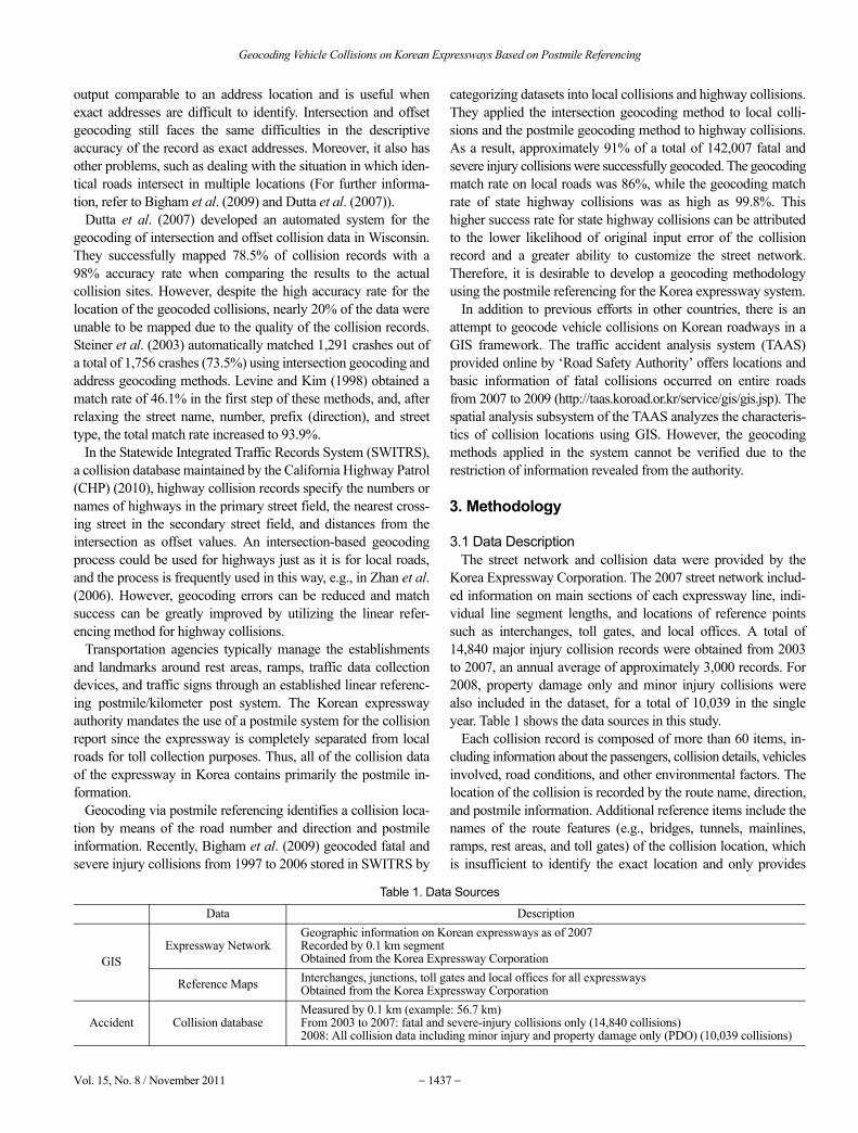
3.1 Data DescriptionThe street network and collision data were provided by the
Korea Expressway Corporation. The 2007 street network includ-ed information on main sections of each expressway line, indi-vidual line segment lengths, and locations of reference pointssuch as interchanges, toll gates, and local offices. A total of14,840 major injury collision records were obtained from 2003to 2007, an annual average of approximately 3,000 records. For2008, property damage only and minor injury collisions werealso included in the dataset, for a total of 10,039 in the singleyear. Table 1 shows the data sources in this study.
Each collision record is composed of more than 60 items, in-cluding information about the passengers, collision details, vehiclesinvolved, road conditions, and other environmental factors. Thelocation of the collision is recorded by the route name, direction,and postmile information. Additional reference items include thenames of the route features (e.g., bridges, tunnels, mainlines,ramps, rest areas, and toll gates) of the collision location, whichis insufficient to identify the exact location and only provides
Table 1. Data Sources
Data Description
GISExpressway Network
Geographic information on Korean expressways as of 2007Recorded by 0.1 km segmentObtained from the Korea Expressway Corporation
Reference Maps Interchanges, junctions, toll gates and local offices for all expresswaysObtained from the Korea Expressway Corporation
Accident Collision databaseMeasured by 0.1 km (example: 56.7 km) From 2003 to 2007: fatal and severe-injury collisions only (14,840 collisions)2008: All collision data including minor injury and property damage only (PDO) (10,039 collisions)

Shin Hyoung Park, John M. Bigham, Seung-Young Kho, Seungmo Kang, and Dong-Kyu Kim
− 1438 − KSCE Journal of Civil Engineering
secondary location information. The postmile geocoding method for Korean expressway is
composed of four steps: creating routes, adding postmile markers(calibration points), calibrating routes, and geocoding collisionsvia linear referencing. ArcGIS 9.2 software and custom toolswritten in Visual Basic for Applications (VBA) were used for theentire process. ArcGIS VBA provides an integrated programm-ing environment to build tools that complement the standardArcGIS software. The following sections detail each of the pro-cessing steps.
3.2 Creating RoutesThe initial step of postmile geocoding is to build the conti-
nuous highway network. Because the existing routes in the basemap from Korea Expressway Corporation are composed of 0.1km segments for a management purpose, those expresswaysegments with the same route number have to be merged into asingle line. We should have been able to complete this step bysimply querying all segments by route number and mergingthem together, but due to errors in the expressway network, therewere occasional problems in creating a single line. For example,some segments appeared to comprise a single line, but, undercloser inspection, the data attributes showed incorrect routenumbers or directions. In order to identify and correct these streetnetwork errors, a custom ArcGIS VBA tool was developed toaid the cleaning process.
After refining the street network, selected segments were mergedinto a single line, as shown in Fig. 2. The codes that indicated linenumber and line name, 0150 and Westcoast, for example, werecombined to create a unique ID (0150-Westcoast) that is stored inthe LR_RouteID field. With the cleaned and merged routesegments, complete routes were finally built using the ‘CreateRoutes’ tool which assigns route IDs to each merged route.
3.3 Adding Postmile MarkersAfter the routes are created, postmile values must be assigned
for known locations along the routes. The ‘Feature Vertices toPoints’ tool in ArcGIS was used to automatically extract the startand end points of each 0.1-km segment that included the knownpostmile value. Other break points from connecting lines werealso extracted to create more calibration points. These calibrationpoints were given postmile values by referencing other known
markers, such as interchanges or junctions. Fig. 3 shows anattribute table of postmile markers.
3.4 Calibrating RoutesOn Korean expressways, postmile values increase along each
route from the westward for horizontal axes and from the south-ward for vertical axes. When using the tool, ‘Create Routes,’coordinate priority was set at the lower left on the map, with thestarting point of the line at 0 km and the ending point at thedefault value of the length predetermined by ArcGIS. However,it was necessary to re-establish postmiles of main segments,since errors occur in the street network and postmiles due to thereconstruction or improvement of expressways. The knownpostmile markers were input into the ‘Calibrate Routes’ tool ofArcGIS to calibrate the routes.
3.5 Geocoding CollisionsAfter calibrating all the routes, geocoding can be completed
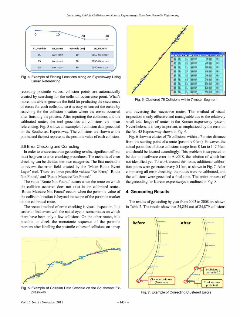
via linear referencing. For example, as shown in Fig. 4, if thestarting point postmile is 0 km in a certain section of Expressway15 and the closing postmile is 30, the positions of the other twopoints with postmile values can be interpolated between thestarting point and closing point in proportion to the length of thewhole section.
The collision records were processed to create a route ID withpostmile values that match the expressway network format toprepare them for use in the ArcGIS tool, ‘Make Route EventLayer.’ If one designates a table for storing calibrated route layerand collision data, a field for storing route ID, and a field for
Fig. 2. Example of the ‘Creating Routes’ Process that Merges Segments into a Single Polyline
Fig. 3. Example of Postmile Markers
Geocoding Vehicle Collisions on Korean Expressways Based on Postmile Referencing
Vol. 15, No. 8 / November 2011 − 1439 −
recording postmile values, collision points are automaticallycreated by searching for the collision occurrence point. What’smore, it is able to generate the field for predicting the occurrenceof errors for each collision, so it is easy to correct the errors bysearching for the collision location where the errors occurredafter finishing the process. After inputting the collisions and thecalibrated routes, the tool geocodes all collisions via linearreferencing. Fig. 5 shows an example of collision data geocodedon the Southcoast Expressway. The collisions are shown as thepoints, and the text represents the postmile value of each collision.
3.6 Error Checking and CorrectingIn order to ensure accurate geocoding results, significant efforts
must be given to error-checking procedures. The methods of errorchecking can be divided into two categories. The first method isto review the error field created by the ‘Make Route EventLayer’ tool. There are three possible values: ‘No Error,’ ‘RouteNot Found,’ and ‘Route Measure Not Found.’
The value ‘Route Not Found’ occurs when the route on whichthe collision occurred does not exist in the calibrated routes.‘Route Measure Not Found’ occurs when the postmile value ofthe collision location is beyond the scope of the postmile markeron the calibrated route.
The second method of error checking is visual inspection. It iseasier to find errors with the naked eye on some routes on whichthere have been only a few collisions. On the other routes, it ispossible to check the monotonic sequence of the postmilemarkers after labelling the postmile values of collisions on a map
and traversing the successive routes. This method of visualinspection is only effective and manageable due to the relativelysmall total length of routes in the Korean expressway system.Nevertheless, it is very important, as emphasized by the error onthe No. 45 Expressway shown in Fig. 6.
Fig. 6 shows a cluster of 76 collisions within a 7-meter distancefrom the starting point of a route (postmile 0 km). However, theactual postmiles of those collisions range from 0 km to 147.5 kmand should be located accordingly. This problem is suspected tobe due to a software error in ArcGIS, the solution of which hasnot identified yet. To work around this issue, additional calibra-tion points were generated every 0.1 km, as shown in Fig. 7. Aftercompleting all error checking, the routes were re-calibrated, andthe collisions were geocoded a final time. The entire process ofthe geocoding for Korean expressways is outlined in Fig. 8.
4. Geocoding Results
The results of geocoding by year from 2003 to 2008 are shownin Table 2. The results show that 24,854 out of 24,879 collisions
Fig. 4. Example of Finding Locations along an Expressway UsingLinear Referencing
Fig. 5. Example of Collision Data Overlaid on the Southcoast Ex-pressway
Fig. 6. Clustered 76 Collisions within 7-meter Segment
Fig. 7. Example of Correcting Clustered Errors

Shin Hyoung Park, John M. Bigham, Seung-Young Kho, Seungmo Kang, and Dong-Kyu Kim
− 1440 − KSCE Journal of Civil Engineering
were geocoded, for an overall match rate of 99.9%. There were24 ‘Route Measure Not Found’ errors, and there was one ‘RouteNot Found’ error. ‘Route Measure Not Found’ errors were theresult of invalid postmile values. For example, Line No. 1 has atotal distance of 416 km, but postmiles of some collisions wereactually recorded at 424 km, 424.5 km, and 425.6 km. Line No.100 has a distance of 128 km, but a collision postmile was recordedat 327.1 km. The only ‘Route Not Found’ error occurred on theroute that was constructed in late 2008. Since the base network wasestablished as of 2007, the new route could not be created.
Table 3 compares the results of published geocoding methods.The results show this study produced much higher geocoded ratethan other studies. Since address geocoding and intersectiongeocoding refer literal information such as prefix, street name,and street type, there might be frequent errors caused by errata,aliases or abbreviations. On the other hand, postmile geocoding
can easily handle any incongruities since it refers numericalinformation such as route number and postmile. An importantresult of our research is also the evaluation of the applicability ofpostmile geocoding methods from different countries. The de-tailed processes and methods between the Korean expresswaysand state highways in California analyzed by Bigham et al.(2009) exhibited differences because the digital road networks ofboth regions were built based on different base networks whichhave dissimilar structures. Moreover, the street networks had amajor fundamental difference in that California is focused onroadway maintenance and management while Korea is attempt-ing to gradually grow its expressway infrastructure.
The California street networks had to account for postmilechanges over time to avoid having a single location on thenetwork with multiple postmile values. In Korea, the biggerchallenge is keeping the street network database up to date withall the latest routes being constructed. However, the overall
Fig. 8. Entire Geocoding Processes for Korean Expressways
Table 2. Geocoding Result on Korean Expressways
2003 2004 2005 2006 2007 2008 SumRoute Not Found 0 0 0 0 0 1 1Route Measure Not Found 5 2 2 2 1 12 24No Error 3,580 3,240 2,878 2,581 2,549 10,026 24,854Total 3,585 3,242 2,880 2,583 2,550 10,039 24,879Match rate 99.86% 99.94% 99.93% 99.92% 99.96% 99.87% 99.90%
Table 3. Comparison of the Results of Published Geocoding Methods
Author Geocoding methods Collisions Road types Crash types % geocoded Scale LocationLevine & Kim (1998) Address 15,975 all all 94.4 County Honolulu, HISteiner et al. (2003) Address 1,756 All Pedestrian 97.9* County Miami Dade, FL
Zhan et al. (2006) Intersection & offset59,247 Highway All 95.6 County Broward, FL35,531 Highway All 97.9 County Palm Beach, FL
Dutta et al. (2007) Intersection & offset 4,351 Local roads All 78.5 State WisconsinBigham et al. (2009) Postmile 56,224 Highway All 99.9 State CaliforniaThis study Postmile 24,879 Freeway All 99.9 State Korea*24.4% out of 1,756 collisions were manually and interactively geocoded.
Fig. 9. Example of Geocoded Collisions from 2003 to 2007

Geocoding Vehicle Collisions on Korean Expressways Based on Postmile Referencing
Vol. 15, No. 8 / November 2011 − 1441 −
framework of the methodology developed for the Korean ex-pressways and state highways in California seemed similar andthe methods for street network cleaning and error checking andthe use of linear referencing to geocode collisions were easilytransferable between Korea and California. Therefore, this studycould provide a geocoding framework for researchers or practi-tioners in other countries that report collisions using postmile-based location coding.
5. Conclusions
This study established a methodology for geocoding collisionson Korean expressways with a high match rate. The expresswaynetwork built through this study can provide a foundation forquickly and accurately geocoding expressway collisions on aregular basis and can be easily updated when new routes areconstructed. The geocoded database of expressway collisionswill allow researchers to identify hot spots or justify road impro-vement projects and gives consideration to spatial factors that atraditional tabular analysis cannot. Collision maps can also beproduced to aid traffic safety campaigns.
Our research also emphasizes the need for a highly accuratestreet network and correct location information for each collisionrecord. The match rate only indicates that collision data weregeocoded correctly on the expressways according to postmilevalues, but this cannot be regarded as an overall measure ofaccuracy. It is difficult to confirm whether the collision locationsgeocoded on the street network match the true location on theground. The closer the street network represents the truelocations and the more accurately collision postmile values areoriginally recorded, the higher the quality of the database will be.
For the years 2003 through 2008, 26,112 vehicle crashes caused2,726 fatalities on expressways in Korea. While collisions onexpressways make up only approximately 2% of the total ofalmost 1,317,000 vehicle crashes on all roads in Korea, the ratioof fatalities to crashes on expressways is just over 7%, which ismuch higher than the ratio for all roads in Korea. This indicatesthat the severity of expressway crashes is higher than that ofcrashes that occur on other types of roads. This increasedseverity results in exponentially increased economic and socialcosts Korean society must burden and emphasizes the need toreduce expressway crashes. The ability to quickly and accuratelygeocode expressway crashes is vital to achieving such areduction and the methods and database developed for this studyprovides a solid foundation for future studies such as crash factoranalysis, hotspot identification, and facility locations optimizedfor accident response activities.
Acknowledgements
This work was supported by National Research Foundation ofKorea Grant funded by the Korean Government (2009-0075811). The generous support from the Engineering ResearchInstitute of Seoul National University, Korea Expressway Cor-
poration, and Safe Transportation Research & Education Centerat U.C. Berkeley is also gratefully acknowledged. The opinionsexpressed in the paper, however, are solely of the authors and donot necessarily reflect the opinions of the respective agencies.The authos also thank the anonymous referees who reviewed anearlier version of this manuscript for their constructive andhelpful comments.
References
Bigham, J. M., Rice, T. M., Pande, S., Lee, J., Park, S. H., Gutierrez, N.B., and Ragland, D. R. (2009). “Geocoding police collision reportdata from california: a comprehensive approach.” InternationalJournal of Health Geographics, 8:72 doi:10.1186/1476-072X-8-72.
California Highway Patrol (2010). Statewide Integrated Traffic RecordsSystems, www.chp.ca.gov/switrs/index.html. Accessed July 21.
Carreker, L. E. and Bachman, W. (2000). “Geographic informationsystem procedures to improve speed and accuracy in locatingcrashes.” In Transportation Research Record: Journal of theTransportation Research Board, No. 1719, Transportation ResearchBoard of the National Academies, Washington, D.C., pp. 215-218.
Craglia, M., Haining, R., and Wiles, P. (2000). “A comparative evalua-tion of approaches to urban crime pattern analysis.” Urban Studies,Vol. 37, No. 4, pp. 711-729.
Dutta, A., Parker, S., Qin, X., Qiu, Z., and Noyce, D. A. (2007). “Systemfor digitizing information on wisconsin’s crash locations.” In Trans-portation Research Record: Journal of the Transportation ResearchBoard, No. 2019, Transportation Research Board of the NationalAcademies, Washington, D.C., pp. 256-264.
ESRI (2008). ArcGIS version 9.2, Environmental Systems ResearchInstitute (ESRI), Redlands, CA, 2008.
Levine, N. and Kim, K. E. (1998). “The location of motor vehiclecrashes in honolulu: a methodology for geocoding intersections.”Computers, Environment and Urban Systems, Vol. 22, No. 6, pp.557-576.
Miller, J. S. and Karr, D. (1998). “Experimental application of globalpositioning system to locate motor vehicle crashes: Impact on timeand accuracy.” In Transportation Research Record: Journal of theTransportation Research Board, No. 1625, Transportation ResearchBoard of the National Academies, Washington, D.C., pp. 41-49.
Rushton, G., Peleg, I., Banerjee, A., Smith, G., and West, M. (2004).“Analyzing geographic patterns of disease incidence: Rates of late-stage colorectal cancer in iowa.” Journal of Medical Systems, Vol.28, No. 3, pp. 223-236.
Sarasua, W. A., Ogle, J. H., and Geoghegan, K. (2008) “Use of globalpositioning system to identify crash locations in South Carolina.” InTransportation Research Record: Journal of the TransportationResearch Board, No. 2064, Transportation Research Board of theNational Academies, Washington, D.C., pp. 43-50.
Steiner, R., Bejleri, I., Yang, X., and Kim, D. H. (2003). “Improvinggeocoding of traffic crashes using a custom ArcGIS address match-ing application.” Presented at 22nd Environmental Systems ResearchInstitute International User Conference, San Diego, CA.
Yang, D. H., Bilaver, L. M., Hayes, O., and George, R. (2004). “Improv-ing geocoding practices-evaluation of geocoding tools.” Journal ofMedical Systems, Vol. 28, No. 4, pp. 361-370.
Zhan, C., Gan, A., and Hadi, M. (2006). “Analyzing freeway servicepatrol data.” Presented at Annual Civil Engineering Conference ofthe American Society of Civil Engineers, Chicago, IL.