Embed Size (px)
Citation preview
Introduction to the Multiuser Geodatabase 5-1Versioning concepts
Introduction to the Multiuser GeodatabaseCopyright © 2005 ESRI. All rights reserved.
Geodatabase Tuningand Performance
Gillian Silvertand
Greg Cunningham
Introduction to the Multiuser Geodatabase 5-2Versioning concepts
2Geodatabase Tuning and PerformanceCopyright © 2005 ESRI. All rights reserved.
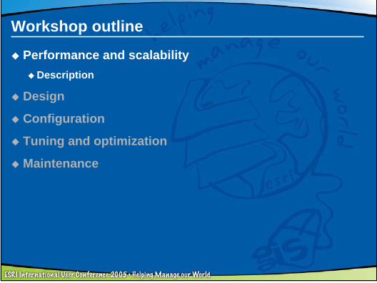
Workshop outline
Performance and scalabilityDescription
Design
Configuration
Tuning and optimization
Maintenance
Introduction to the Multiuser Geodatabase 5-3Versioning concepts
3Geodatabase Tuning and PerformanceCopyright © 2005 ESRI. All rights reserved.
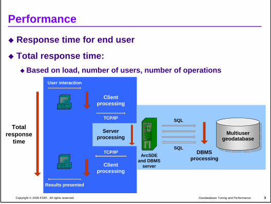
Performance
Response time for end user
Total response time:Based on load, number of users, number of operations
User interaction
ArcMap
Clientprocessing
TCP/IP
ArcSDEand DBMS
server
SQL
SQLDBMS
processingTCP/IP
Serverprocessing
ArcMap
Results presented
Totalresponse
time
Clientprocessing
MultiusergeodatabaseMultiuser
geodatabase
Introduction to the Multiuser Geodatabase 5-4Versioning concepts
4Geodatabase Tuning and PerformanceCopyright © 2005 ESRI. All rights reserved.
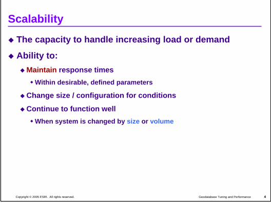
Scalability
The capacity to handle increasing load or demand
Ability to:Maintain response times
Within desirable, defined parameters
Change size / configuration for conditions
Continue to function wellWhen system is changed by size or volume
Introduction to the Multiuser Geodatabase 5-5Versioning concepts
5Geodatabase Tuning and PerformanceCopyright © 2005 ESRI. All rights reserved.
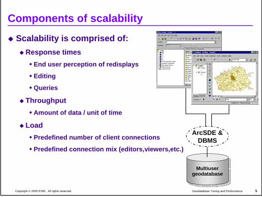
Components of scalability
Scalability is comprised of:Response times
End user perception of redisplays
Editing
Queries
ThroughputAmount of data / unit of time
Load Predefined number of client connections
Predefined connection mix (editors,viewers,etc.)
MultiusergeodatabaseMultiuser
geodatabase
ArcSDE &DBMS
Introduction to the Multiuser Geodatabase 5-6Versioning concepts
6Geodatabase Tuning and PerformanceCopyright © 2005 ESRI. All rights reserved.
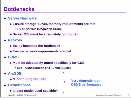
BottlenecksServer Hardware
Ensure storage, CPUs, memory requirements are metESRI Systems Integration Group
Server O/S must be adequately configured
NetworkEasily becomes the bottleneckEnsure network requirements are met
DBMSMust be adequately tuned specifically for GDB
See – Configuration and Tuning Guides
ArcSDEMinor tuning required
GeodatabaseIs data model used scalable?
Very dependent on DBMS performance
Introduction to the Multiuser Geodatabase 5-7Versioning concepts
7Geodatabase Tuning and PerformanceCopyright © 2005 ESRI. All rights reserved.
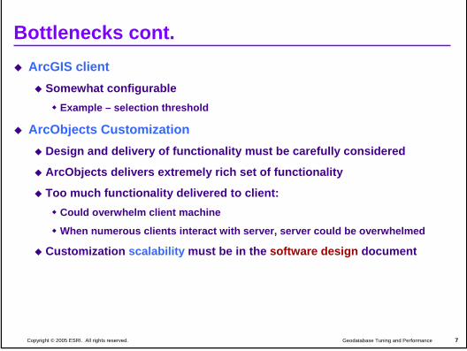
Bottlenecks cont.ArcGIS client
Somewhat configurableExample – selection threshold
ArcObjects CustomizationDesign and delivery of functionality must be carefully considered
ArcObjects delivers extremely rich set of functionality
Too much functionality delivered to client:Could overwhelm client machine
When numerous clients interact with server, server could be overwhelmed
Customization scalability must be in the software design document
Introduction to the Multiuser Geodatabase 5-8Versioning concepts
8Geodatabase Tuning and PerformanceCopyright © 2005 ESRI. All rights reserved.
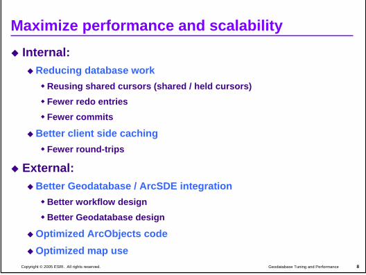
Maximize performance and scalability Internal:
Reducing database workReusing shared cursors (shared / held cursors)Fewer redo entriesFewer commits
Better client side cachingFewer round-trips
External:Better Geodatabase / ArcSDE integration
Better workflow designBetter Geodatabase design
Optimized ArcObjects codeOptimized map use
Introduction to the Multiuser Geodatabase 5-9Versioning concepts
9Geodatabase Tuning and PerformanceCopyright © 2005 ESRI. All rights reserved.
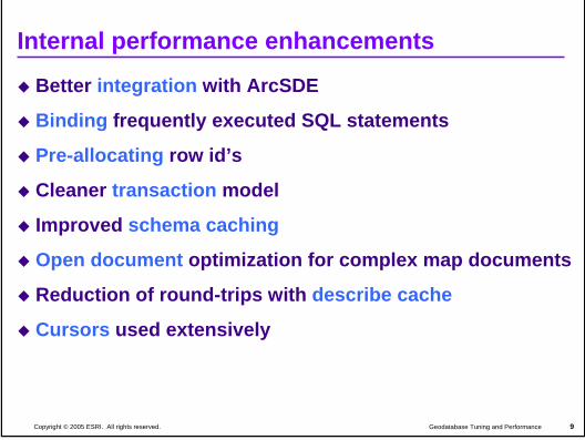
Internal performance enhancements
Better integration with ArcSDE
Binding frequently executed SQL statements
Pre-allocating row id’s
Cleaner transaction model
Improved schema caching
Open document optimization for complex map documents
Reduction of round-trips with describe cache
Cursors used extensively
Introduction to the Multiuser Geodatabase 5-10Versioning concepts
10Geodatabase Tuning and PerformanceCopyright © 2005 ESRI. All rights reserved.
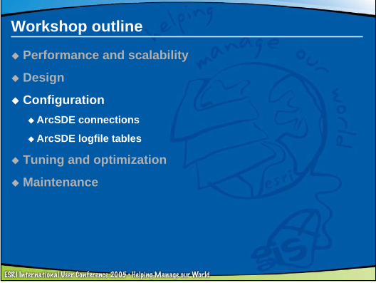
Workshop outline
Performance and scalability
DesignGeodatabase design issues
Configuration
Tuning and optimization
Maintenance
Introduction to the Multiuser Geodatabase 5-11Versioning concepts
11Geodatabase Tuning and PerformanceCopyright © 2005 ESRI. All rights reserved.
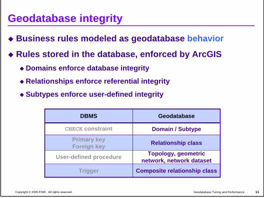
Geodatabase integrity
Business rules modeled as geodatabase behavior
Rules stored in the database, enforced by ArcGISDomains enforce database integrity
Relationships enforce referential integrity
Subtypes enforce user-defined integrity
Topology, geometric network, network datasetUser-defined procedure
Relationship classPrimary keyForeign key
Domain / SubtypeCHECK constraint
GeodatabaseDBMS
Composite relationship classTrigger
Introduction to the Multiuser Geodatabase 5-12Versioning concepts
12Geodatabase Tuning and PerformanceCopyright © 2005 ESRI. All rights reserved.
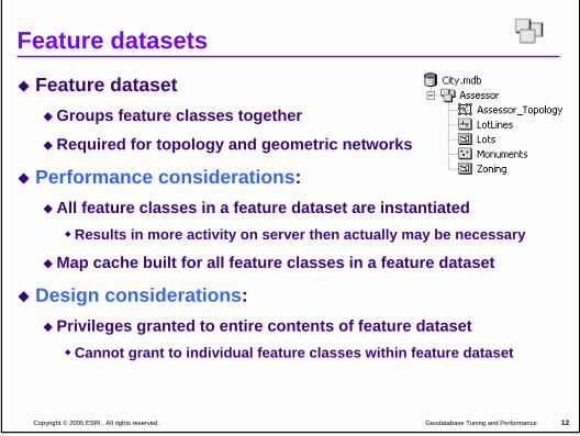
Feature datasets
Feature datasetGroups feature classes together
Required for topology and geometric networks
Performance considerations:All feature classes in a feature dataset are instantiated
Results in more activity on server then actually may be necessary
Map cache built for all feature classes in a feature dataset
Design considerations:Privileges granted to entire contents of feature dataset
Cannot grant to individual feature classes within feature dataset
Introduction to the Multiuser Geodatabase 5-13Versioning concepts
13Geodatabase Tuning and PerformanceCopyright © 2005 ESRI. All rights reserved.
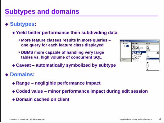
Subtypes and domains
Subtypes:Yield better performance then subdividing data
More feature classes results in more queries –one query for each feature class displayed
DBMS more capable of handling very largetables vs. high volume of concurrent SQL
Caveat – automatically symbolized by subtype
Domains:Range – negligible performance impact
Coded value – minor performance impact during edit session
Domain cached on client
Introduction to the Multiuser Geodatabase 5-14Versioning concepts
14Geodatabase Tuning and PerformanceCopyright © 2005 ESRI. All rights reserved.
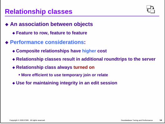
Relationship classes
An association between objectsFeature to row, feature to feature
Performance considerations:Composite relationships have higher cost
Relationship classes result in additional roundtrips to the server
Relationship class always turned onMore efficient to use temporary join or relate
Use for maintaining integrity in an edit session
Introduction to the Multiuser Geodatabase 5-15Versioning concepts
15Geodatabase Tuning and PerformanceCopyright © 2005 ESRI. All rights reserved.
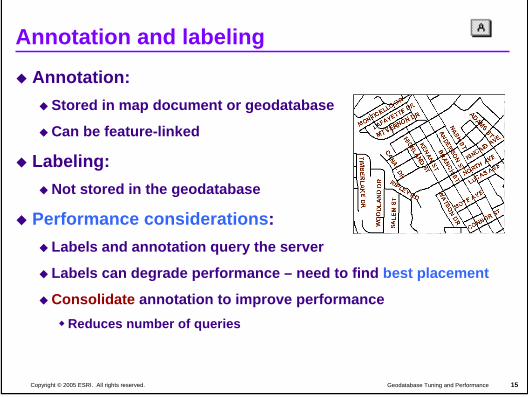
Annotation and labeling
Annotation:Stored in map document or geodatabase
Can be feature-linked
Labeling:Not stored in the geodatabase
Performance considerations:Labels and annotation query the server
Labels can degrade performance – need to find best placement
Consolidate annotation to improve performanceReduces number of queries
Introduction to the Multiuser Geodatabase 5-16Versioning concepts
16Geodatabase Tuning and PerformanceCopyright © 2005 ESRI. All rights reserved.
Spatial relationships
Geometric networks:Performance will degrade with many feature classes
Degradation dependent on hardware and network resources
Geodatabase has to rebuild connectivity when editing
All feature classes in the network will be returned
Network datasets and Topology:Behavior on request
Built (Network Dataset) or Validate (Topology) as needed
Very little associated overheadLike simple feature classes
Introduction to the Multiuser Geodatabase 5-17Versioning concepts
17Geodatabase Tuning and PerformanceCopyright © 2005 ESRI. All rights reserved.
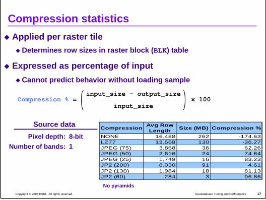
Compression statisticsApplied per raster tile
Determines row sizes in raster block (BLK) table
Expressed as percentage of inputCannot predict behavior without loading sample
input_size – output_size
input_sizex 100Compression % =
Compression Avg Row Length Size (MB) Compression %
NONE 16,488 262 -174.63LZ77 13,568 130 -36.27JPEG (75) 3,868 36 62.26JPEG (50) 2,616 24 74.84JPEG (25) 1,749 16 83.23JP2 (200) 8,030 91 4.61JP2 (130) 1,984 18 81.13JP2 (60) 284 3 96.86
No pyramids
Source dataPixel depth: 8-bit
Number of bands: 1
Introduction to the Multiuser Geodatabase 5-18Versioning concepts
18Geodatabase Tuning and PerformanceCopyright © 2005 ESRI. All rights reserved.
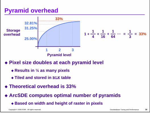
Pyramid overhead
Pixel size doubles at each pyramid levelResults in ¼ as many pixelsTiled and stored in BLK table
Theoretical overhead is 33%
ArcSDE computes optimal number of pyramidsBased on width and height of raster in pixels
Pyramid level
Storageoverhead
1 2 3
33%
25.00%
31.25%32.81%
1 +14
+1
16+
164
… = 13
= 33%
Introduction to the Multiuser Geodatabase 5-19Versioning concepts
19Geodatabase Tuning and PerformanceCopyright © 2005 ESRI. All rights reserved.
Workshop outline
Performance and scalability
Design
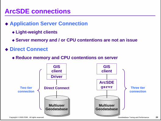
ConfigurationArcSDE connections
ArcSDE logfile tables
Tuning and optimization
Maintenance
Introduction to the Multiuser Geodatabase 5-20Versioning concepts
20Geodatabase Tuning and PerformanceCopyright © 2005 ESRI. All rights reserved.
Application Server ConnectionLight-weight clients
Server memory and / or CPU contentions are not an issue
Direct ConnectReduce memory and CPU contentions on server
ArcSDE connections
MultiuserGeodatabase
Direct Connect
GISclientDriver
MultiuserGeodatabase
ArcSDEgsrvr
GISclient
Three tierconnection
Two tierconnection
Introduction to the Multiuser Geodatabase 5-21Versioning concepts
21Geodatabase Tuning and PerformanceCopyright © 2005 ESRI. All rights reserved.
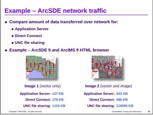
Example – ArcSDE network trafficCompare amount of data transferred over network for:
Application Server
Direct Connect
UNC file sharing
Example – ArcSDE 9 and ArcIMS 9 HTML browser
Image 1 (vector only)
Application Server:
Direct Connect:
UNC file sharing:
137 KB
179 KB
1124 KB
Application Server:
Direct Connect:
UNC file sharing:
542 KB
686 KB
116095 KB
Image 2 (vector and image)
Introduction to the Multiuser Geodatabase 5-22Versioning concepts
22Geodatabase Tuning and PerformanceCopyright © 2005 ESRI. All rights reserved.
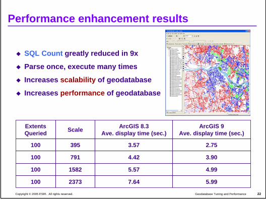
Performance enhancement results
SQL Count greatly reduced in 9x
Parse once, execute many times
Increases scalability of geodatabase
Increases performance of geodatabase
Extents Queried Scale ArcGIS 8.3
Ave. display time (sec.)ArcGIS 9
Ave. display time (sec.)
100 395 3.57 2.75
100 791 4.42 3.90
100 1582 5.57 4.99
100 2373 7.64 5.99
Introduction to the Multiuser Geodatabase 5-23Versioning concepts
23Geodatabase Tuning and PerformanceCopyright © 2005 ESRI. All rights reserved.
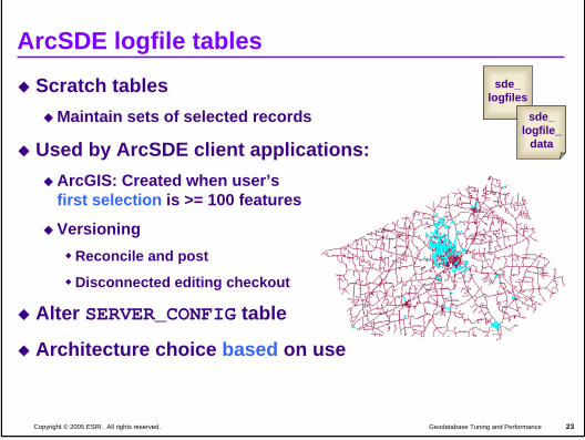
ArcSDE logfile tables
Scratch tablesMaintain sets of selected records
Used by ArcSDE client applications: ArcGIS: Created when user’s first selection is >= 100 features
VersioningReconcile and post
Disconnected editing checkout
Alter SERVER_CONFIG table
Architecture choice based on use
sde_logfiles
sde_logfile_
data
Introduction to the Multiuser Geodatabase 5-24Versioning concepts
24Geodatabase Tuning and PerformanceCopyright © 2005 ESRI. All rights reserved.
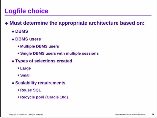
Logfile choice
Must determine the appropriate architecture based on:DBMS
DBMS usersMultiple DBMS users
Single DBMS users with multiple sessions
Types of selections createdLarge
Small
Scalability requirementsReuse SQL
Recycle pool (Oracle 10g)
Introduction to the Multiuser Geodatabase 5-25Versioning concepts
25Geodatabase Tuning and PerformanceCopyright © 2005 ESRI. All rights reserved.
Index fragmentation It is all about indexesThings to look for:
Slower performance between compressesMassive edits Check clustering_factor
Take “good” traces / snapshots to comparetkprof, Profile, Event Monitor, Onstat
Trace “bad” and review execution plans for changeArcSDE does not coalesce or rebuild after compress
Rebuild, coalesce or defragment indexesMaintain index statistics
Introduction to the Multiuser Geodatabase 5-26Versioning concepts
26Geodatabase Tuning and PerformanceCopyright © 2005 ESRI. All rights reserved.
Index management
Updating, inserting and deleting causes fragmentationIndexes can become unbalanced
Fragmentation leads to increased I/O
Fragmentation leads to performance issues
Rebuild indexesReduces logical I/O
Rebuild – reorganizes indexSdetable –o rebuild_indexe
Maintain index statistics
Introduction to the Multiuser Geodatabase 5-27Versioning concepts
27Geodatabase Tuning and PerformanceCopyright © 2005 ESRI. All rights reserved.
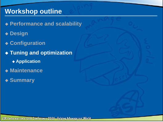
Workshop outline
Performance and scalability
Design
Configuration
Tuning and optimizationApplication
Maintenance
Summary
Introduction to the Multiuser Geodatabase 5-28Versioning concepts
28Geodatabase Tuning and PerformanceCopyright © 2005 ESRI. All rights reserved.
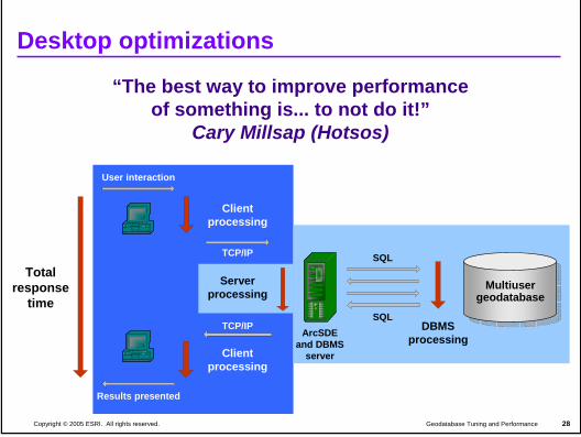
Desktop optimizations
“The best way to improve performanceof something is... to not do it!”
Cary Millsap (Hotsos)
User interaction
ArcMap
Clientprocessing
TCP/IP
ArcSDEand DBMS
server
SQL
SQLDBMS
processingTCP/IP
Serverprocessing
ArcMap
Results presented
Totalresponse
time
Clientprocessing
MultiusergeodatabaseMultiuser
geodatabase
Introduction to the Multiuser Geodatabase 5-29Versioning concepts
29Geodatabase Tuning and PerformanceCopyright © 2005 ESRI. All rights reserved.
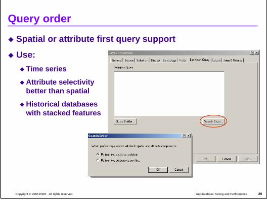
Query order
Spatial or attribute first query support
Use:Time series
Attribute selectivitybetter than spatial
Historical databaseswith stacked features
Introduction to the Multiuser Geodatabase 5-30Versioning concepts
30Geodatabase Tuning and PerformanceCopyright © 2005 ESRI. All rights reserved.
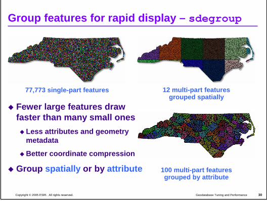
Group features for rapid display – sdegroup
Fewer large features draw faster than many small ones
Less attributes and geometry metadata
Better coordinate compression
Group spatially or by attribute
77,773 single-part features 12 multi-part featuresgrouped spatially
100 multi-part featuresgrouped by attribute
Introduction to the Multiuser Geodatabase 5-31Versioning concepts
31Geodatabase Tuning and PerformanceCopyright © 2005 ESRI. All rights reserved.
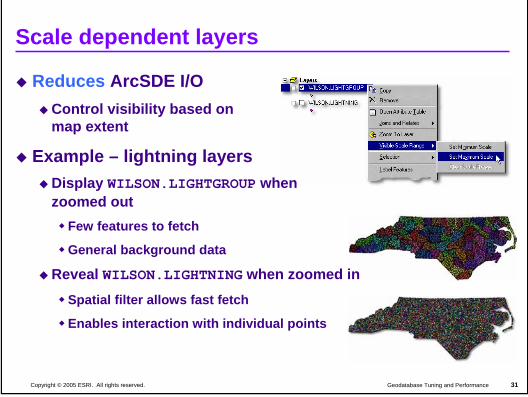
Scale dependent layers
Reduces ArcSDE I/OControl visibility based on map extent
Example – lightning layersDisplay WILSON.LIGHTGROUP whenzoomed out
Few features to fetch
General background data
Reveal WILSON.LIGHTNING when zoomed inSpatial filter allows fast fetch
Enables interaction with individual points
Introduction to the Multiuser Geodatabase 5-32Versioning concepts
32Geodatabase Tuning and PerformanceCopyright © 2005 ESRI. All rights reserved.
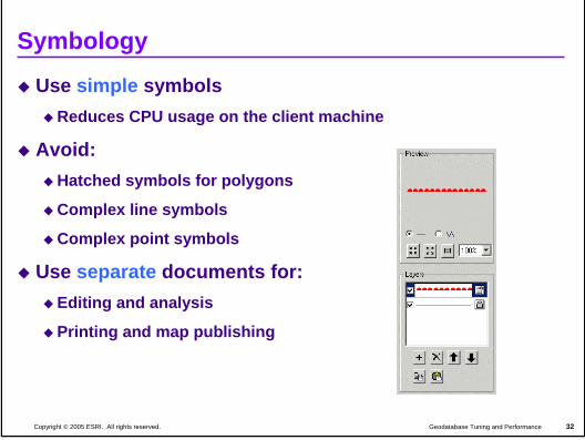
Symbology
Use simple symbolsReduces CPU usage on the client machine
Avoid:Hatched symbols for polygons
Complex line symbols
Complex point symbols
Use separate documents for:Editing and analysis
Printing and map publishing
Introduction to the Multiuser Geodatabase 5-33Versioning concepts
33Geodatabase Tuning and PerformanceCopyright © 2005 ESRI. All rights reserved.
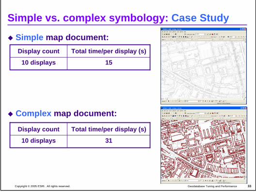
Simple vs. complex symbology: Case Study
Simple map document:
Complex map document:
Total time/per display (s)Display count
1510 displays
3110 displays
Total time/per display (s)Display count
Introduction to the Multiuser Geodatabase 5-34Versioning concepts
34Geodatabase Tuning and PerformanceCopyright © 2005 ESRI. All rights reserved.
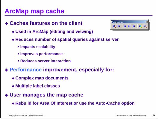
ArcMap map cache
Caches features on the clientUsed in ArcMap (editing and viewing)
Reduces number of spatial queries against serverImpacts scalability
Improves performance
Reduces server interaction
Performance improvement, especially for:Complex map documents
Multiple label classes
User manages the map cacheRebuild for Area Of Interest or use the Auto-Cache option
Introduction to the Multiuser Geodatabase 5-35Versioning concepts
35Geodatabase Tuning and PerformanceCopyright © 2005 ESRI. All rights reserved.
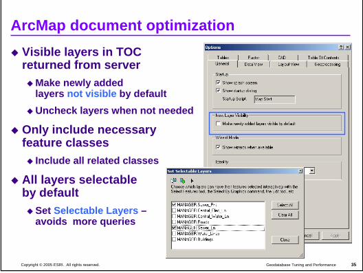
ArcMap document optimizationVisible layers in TOCreturned from server
Make newly addedlayers not visible by defaultUncheck layers when not needed
Only include necessaryfeature classes
Include all related classes
All layers selectableby default
Set Selectable Layers –avoids more queries
Introduction to the Multiuser Geodatabase 5-36Versioning concepts
36Geodatabase Tuning and PerformanceCopyright © 2005 ESRI. All rights reserved.
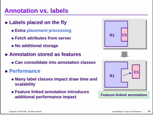
Annotation vs. labels
Labels placed on the flyExtra placement processing
Fetch attributes from server
No additional storage
Annotation stored as featuresCan consolidate into annotation classes
PerformanceMany label classes impact draw time and scalability
Feature linked annotation introduces additional performance impact
C1R1
C1R1
Feature-linked annotation
Introduction to the Multiuser Geodatabase 5-37Versioning concepts
37Geodatabase Tuning and PerformanceCopyright © 2005 ESRI. All rights reserved.
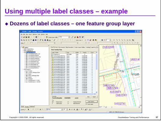
Using multiple label classes – example
Dozens of label classes – one feature group layer
Introduction to the Multiuser Geodatabase 5-38Versioning concepts
38Geodatabase Tuning and PerformanceCopyright © 2005 ESRI. All rights reserved.
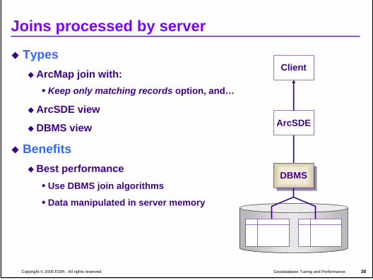
Joins processed by server
TypesArcMap join with:
Keep only matching records option, and…
ArcSDE view
DBMS view
BenefitsBest performance
Use DBMS join algorithms
Data manipulated in server memory
Client
DBMSDBMS
ArcSDE
Introduction to the Multiuser Geodatabase 5-39Versioning concepts
39Geodatabase Tuning and PerformanceCopyright © 2005 ESRI. All rights reserved.
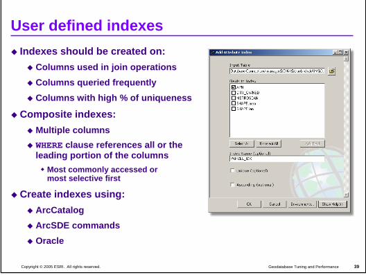
User defined indexesIndexes should be created on:
Columns used in join operationsColumns queried frequentlyColumns with high % of uniqueness
Composite indexes:Multiple columnsWHERE clause references all or the leading portion of the columns
Most commonly accessed or most selective first
Create indexes using:ArcCatalogArcSDE commandsOracle
Introduction to the Multiuser Geodatabase 5-40Versioning concepts
40Geodatabase Tuning and PerformanceCopyright © 2005 ESRI. All rights reserved.
DemonstrationOptimizing ArcMap documents
Introduction to the Multiuser Geodatabase 5-41Versioning concepts
41Geodatabase Tuning and PerformanceCopyright © 2005 ESRI. All rights reserved.
Workshop outline
Performance and scalability
Design
Configuration
Tuning and optimization
MaintenanceMultiuser database
Summary
Introduction to the Multiuser Geodatabase 5-42Versioning concepts
42Geodatabase Tuning and PerformanceCopyright © 2005 ESRI. All rights reserved.
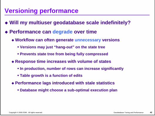
Versioning performance
Will my multiuser geodatabase scale indefinitely?
Performance can degrade over timeWorkflow can often generate unnecessary versions
Versions may just “hang-out” on the state tree
Prevents state tree from being fully compressed
Response time increases with volume of statesIn production, number of rows can increase significantly
Table growth is a function of edits
Performance lags introduced with stale statisticsDatabase might choose a sub-optimal execution plan
Introduction to the Multiuser Geodatabase 5-43Versioning concepts
43Geodatabase Tuning and PerformanceCopyright © 2005 ESRI. All rights reserved.
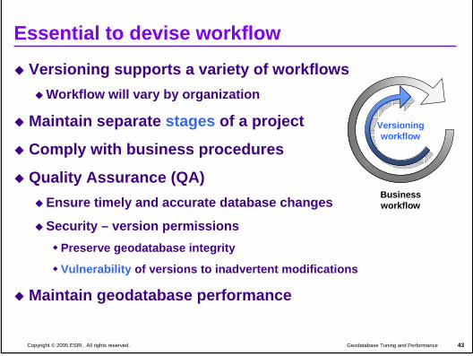
Versioning supports a variety of workflowsWorkflow will vary by organization
Maintain separate stages of a project
Comply with business procedures
Quality Assurance (QA) Ensure timely and accurate database changes
Security – version permissionsPreserve geodatabase integrity
Vulnerability of versions to inadvertent modifications
Maintain geodatabase performance
Essential to devise workflow
Versioningworkflow
Businessworkflow
Introduction to the Multiuser Geodatabase 5-44Versioning concepts
44Geodatabase Tuning and PerformanceCopyright © 2005 ESRI. All rights reserved.
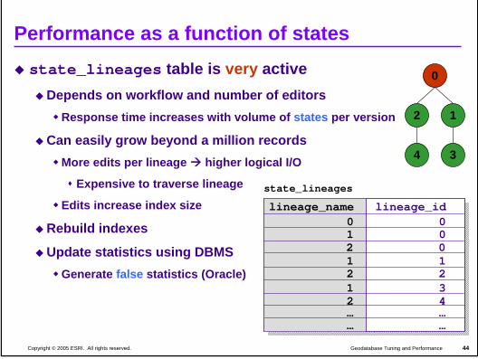
Performance as a function of statesstate_lineages table is very active
Depends on workflow and number of editorsResponse time increases with volume of states per version
Can easily grow beyond a million recordsMore edits per lineage higher logical I/O
Expensive to traverse lineage
Edits increase index size
Rebuild indexes
Update statistics using DBMSGenerate false statistics (Oracle)
state_lineages
lineage_name lineage_id0 01 0
1 12 21 3
… …… …
2 0
2 4
0
12
4 3
Introduction to the Multiuser Geodatabase 5-45Versioning concepts
45Geodatabase Tuning and PerformanceCopyright © 2005 ESRI. All rights reserved.
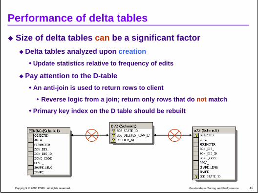
Performance of delta tables
Size of delta tables can be a significant factorDelta tables analyzed upon creation
Update statistics relative to frequency of edits
Pay attention to the D-tableAn anti-join is used to return rows to client
Reverse logic from a join; return only rows that do not match
Primary key index on the D table should be rebuilt
Introduction to the Multiuser Geodatabase 5-46Versioning concepts
46Geodatabase Tuning and PerformanceCopyright © 2005 ESRI. All rights reserved.
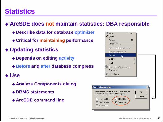
Statistics
ArcSDE does not maintain statistics; DBA responsibleDescribe data for database optimizer
Critical for maintaining performance
Updating statisticsDepends on editing activity
Before and after database compress
Use Analyze Components dialog
DBMS statements
ArcSDE command line
Introduction to the Multiuser Geodatabase 5-47Versioning concepts
47Geodatabase Tuning and PerformanceCopyright © 2005 ESRI. All rights reserved.
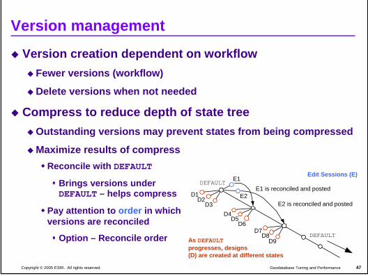
Version management
Version creation dependent on workflowFewer versions (workflow)
Delete versions when not needed
Compress to reduce depth of state treeOutstanding versions may prevent states from being compressed
Maximize results of compressReconcile with DEFAULT
Brings versions underDEFAULT – helps compress
Pay attention to order in whichversions are reconciled
Option – Reconcile order
D1D2
D3
E1DEFAULT
E1 is reconciled and postedE2
E2 is reconciled and posted
DEFAULT
Edit Sessions (E)
As DEFAULTprogresses, designs(D) are created at different states
D4D5
D6D7
D8D9
Introduction to the Multiuser Geodatabase 5-48Versioning concepts
48Geodatabase Tuning and PerformanceCopyright © 2005 ESRI. All rights reserved.
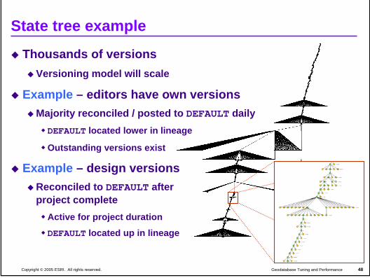
State tree example
Thousands of versionsVersioning model will scale
Example – editors have own versionsMajority reconciled / posted to DEFAULT daily
DEFAULT located lower in lineage
Outstanding versions exist
Example – design versionsReconciled to DEFAULT afterproject complete
Active for project duration
DEFAULT located up in lineage
Introduction to the Multiuser Geodatabase 5-49Versioning concepts
49Geodatabase Tuning and PerformanceCopyright © 2005 ESRI. All rights reserved.
Compressing the database
Maintains performanceMoves common rows from delta tables into base tablesReduces depth of state tree
Removes redundant rows, unreferenced (save points) and orphaned states
49
7150
DEFAULT
53
0
QA
Zoning
Parcels
54Parcels_mnt
55
56 76
49
7850
54
0
Before
After
78
Introduction to the Multiuser Geodatabase 5-50Versioning concepts
50Geodatabase Tuning and PerformanceCopyright © 2005 ESRI. All rights reserved.
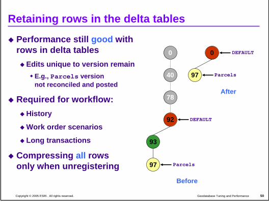
Retaining rows in the delta tables
Performance still good withrows in delta tables
Edits unique to version remainE.g., Parcels versionnot reconciled and posted
Required for workflow:History
Work order scenarios
Long transactions
Compressing all rowsonly when unregistering
Before
0
78
40
92 DEFAULT
Parcels
93
97
After
DEFAULT0
97 Parcels
Introduction to the Multiuser Geodatabase 5-51Versioning concepts
51Geodatabase Tuning and PerformanceCopyright © 2005 ESRI. All rights reserved.
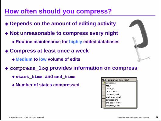
How often should you compress?
Depends on the amount of editing activity
Not unreasonable to compress every nightRoutine maintenance for highly edited databases
Compress at least once a weekMedium to low volume of edits
compress_log provides information on compressstart_time and end_time
Number of states compressed
Introduction to the Multiuser Geodatabase 5-52Versioning concepts
52Geodatabase Tuning and PerformanceCopyright © 2005 ESRI. All rights reserved.
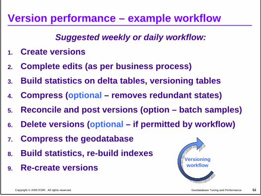
Version performance – example workflow Suggested weekly or daily workflow:
1. Create versions2. Complete edits (as per business process)3. Build statistics on delta tables, versioning tables4. Compress (optional – removes redundant states)5. Reconcile and post versions (option – batch samples) 6. Delete versions (optional – if permitted by workflow)7. Compress the geodatabase8. Build statistics, re-build indexes9. Re-create versions
Versioningworkflow
Introduction to the Multiuser Geodatabase 5-53Versioning concepts
53Geodatabase Tuning and PerformanceCopyright © 2005 ESRI. All rights reserved.
Workshop outline
Performance and scalability
Design
Configuration
Tuning and optimization
Maintenance
Summary
Introduction to the Multiuser Geodatabase 5-54Versioning concepts
54Geodatabase Tuning and PerformanceCopyright © 2005 ESRI. All rights reserved.
Summary
Your actions affect your performance!
Remember to:Design efficient geodatabase architecture
Follow DBMS tuning and configuration recommendations
Optimize map documents
Maintain indexes and statistics
Design efficient versioning workflow
Compress

Introduction to the Multiuser Geodatabase 5-55Versioning concepts
55Geodatabase Tuning and PerformanceCopyright © 2005 ESRI. All rights reserved.
Additional Resources at the Conference
Technical WorkshopsAdministration for Oracle
Tuesday 1:30, Room 10 / Thursday 8:30, Room 10
Administration for SQL ServerWednesday 8:30, Room 10 / Thursday 1:30, Room 10
Geodatabase Tuning and PerformanceWednesday 10:30, Room 1A / Thursday 3:30, Room 1A
Integrating ArcSDE with Enterprise DatabasesTuesday 3:30, Room 1A / Thursday 10:30, Room 1A
ArcSDE product island
Doctor’s Office
Introduction to the Multiuser Geodatabase 5-56Versioning concepts
56Geodatabase Tuning and PerformanceCopyright © 2005 ESRI. All rights reserved.
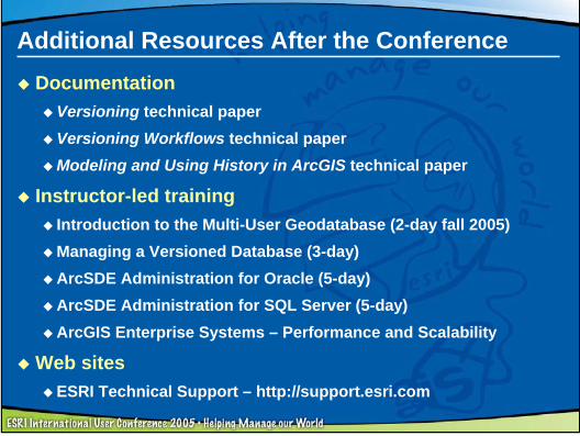
Additional Resources After the ConferenceDocumentation
Versioning technical paperVersioning Workflows technical paperModeling and Using History in ArcGIS technical paper
Instructor-led trainingIntroduction to the Multi-User Geodatabase (2-day fall 2005)Managing a Versioned Database (3-day)ArcSDE Administration for Oracle (5-day)ArcSDE Administration for SQL Server (5-day)ArcGIS Enterprise Systems – Performance and Scalability
Web sitesESRI Technical Support – http://support.esri.com

Introduction to the Multiuser Geodatabase 5-57Versioning concepts
57Geodatabase Tuning and PerformanceCopyright © 2005 ESRI. All rights reserved.
GIS Education and Training Survey
We’d like your feedbackHow do you use our software?
What training do you need?
How can we help you succeed?
Free Virtual Campus Web WorkshopVisit the Virtual Campus/Training/ESRI Press Island
Online until August 15, 2005
Web site: www.esri.com/trainingsurvey/

Introduction to the Multiuser Geodatabase 5-58Versioning concepts
58Geodatabase Tuning and PerformanceCopyright © 2005 ESRI. All rights reserved.
Thank you!
Questions?
Reminder: Workshop evaluation