Embed Size (px)
Citation preview
GEOGRAPHERS AND MODELS
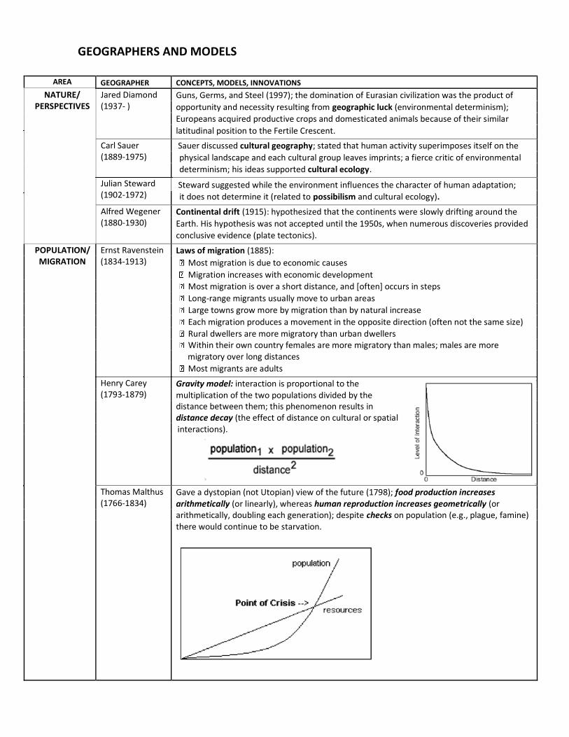
AREA GEOGRAPHER CONCEPTS, MODELS, INNOVATIONS
NATURE/ PERSPECTIVES
Jared Diamond (1937- )
Guns, Germs, and Steel (1997); the domination of Eurasian civilization was the product of
opportunity and necessity resulting from geographic luck (environmental determinism);
Europeans acquired productive crops and domesticated animals because of their similar
latitudinal position to the Fertile Crescent.
Carl Sauer (1889-1975)
Sauer discussed cultural geography; stated that human activity superimposes itself on the
physical landscape and each cultural group leaves imprints; a fierce critic of environmental
Julian Steward (1902-1972)
determinism; his ideas supported cultural ecology.
Steward suggested while the environment influences the character of human adaptation;
it does not determine it (related to possibilism and cultural ecology).
Alfred Wegener (1880-1930)
Continental drift (1915): hypothesized that the continents were slowly drifting around the
Earth. His hypothesis was not accepted until the 1950s, when numerous discoveries provided
conclusive evidence (plate tectonics).
POPULATION/ MIGRATION
Ernst Ravenstein (1834-1913)
Laws of migration (1885):
Most migration is due to economic causes
Migration increases with economic development
Most migration is over a short distance, and [often] occurs in steps
Long-range migrants usually move to urban areas
Large towns grow more by migration than by natural increase
Each migration produces a movement in the opposite direction (often not the same size)
Rural dwellers are more migratory than urban dwellers Within their own country females are more migratory than males; males are more migratory over long distances
Most migrants are adults
Henry Carey (1793-1879)
Gravity model: interaction is proportional to the multiplication of the two populations divided by the distance between them; this phenomenon results in distance decay (the effect of distance on cultural or spatial
interactions).
Thomas Malthus (1766-1834)
Gave a dystopian (not Utopian) view of the future (1798); food production increases arithmetically (or linearly), whereas human reproduction increases geometrically (or arithmetically, doubling each generation); despite checks on population (e.g., plague, famine) there would continue to be starvation.
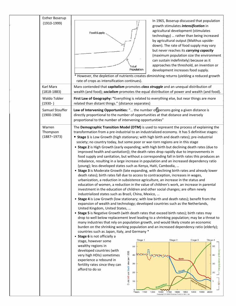
Esther Boserup In 1965, Boserup discussed that population
(1910-1999)
growth stimulates intensification in
agricultural development (stimulates
technology) … rather than being increased
by agricultural output (Malthus upside-
down). The rate of food supply may vary
but never reaches its carrying capacity
(maximum population size the environment
can sustain indefinitely) because as it
approaches the threshold, an invention or
development increases food supply.
* However, the depletion of nutrients creates diminishing returns (yielding a reduced growth
rate of crops as intensification continues).
Karl Marx Marx contended that capitalism promotes class struggle and an unequal distribution of
(1818-1883) wealth (and food); socialism promotes the equal distribution of power and wealth (and food).
Waldo Tobler First Law of Geography: “Everything is related to everything else, but near things are more
(1930- ) related than distant things.” (distance separates)
Samuel Stouffer Law of Intervening Opportunities: “… the number of persons going a given distance is
(1900-1960) directly proportional to the number of opportunities at that distance and inversely
proportional to the number of intervening opportunities”
Warren Thompson (1887–1973)
The Demographic Transition Model (DTM) is used to represent the process of explaining the transformation from a pre-industrial to an industrialized economy. It has 5 definitive stages:
• Stage 1 is Low Growth (high stationary; with high birth and death rates); pre-industrial
society; no country today, but some poor or war-torn regions are in this stage
• Stage 2 is High Growth (early expanding; with high birth but declining death rates (due to improved health and sanitation)); the death rates drop rapidly due to improvements in food supply and sanitation, but without a corresponding fall in birth rates this produces an imbalance, resulting in a large increase in population and an increased dependency ratio (young); less developed states such as Kenya, Haiti, Cambodia, …
• Stage 3 is Moderate Growth (late expanding, with declining birth rates and already lower death rates); birth rates fall due to access to contraception, increases in wages, urbanization, a reduction in subsistence agriculture, an increase in the status and education of women, a reduction in the value of children's work, an increase in parental investment in the education of children and other social changes; are often newly industrialized states such as Brazil, China, Mexico, …
• Stage 4 is Low Growth (low stationary; with low birth and death rates); benefit from the expansion of wealth and technology; developed countries such as the Netherlands, United Kingdom, United States, …
• Stage 5 is Negative Growth (with death rates that exceed birth rates); birth rates may drop to well below replacement level leading to a shrinking population; may be a threat to many industries that rely on population growth, and would likely create an economic burden on the shrinking working population and an increased dependency ratio (elderly); countries such as Japan, Italy, and Germany *
• Stage 6 is not officially a stage, however some wealthy regions in developed countries (with very high HDIs) sometimes experience a rebound in fertility rates since they can afford to do so
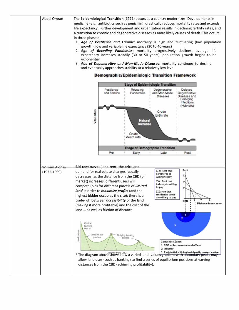
Abdel Omran The Epidemiological Transition (1971) occurs as a country modernizes. Developments in medicine (e.g., antibiotics such as penicillin), drastically reduces mortality rates and extends life expectancy. Further development and urbanization results in declining fertility rates, and a transition to chronic and degenerative diseases as more likely causes of death. This occurs in three phases: 1. Age of Pestilence and Famine: mortality is high and fluctuating (low population
growth); low and variable life expectancy (20 to 40 years) 2. Age of Receding Pandemics: mortality progressively declines; average life
expectancy increases steadily (30 to 50 years); population growth begins to be exponential
3. Age of Degenerative and Man-Made Diseases: mortality continues to decline and eventually approaches stability at a relatively low level
William Alonso (1933-1999)
Bid-rent curve: (land-rent) the price and demand for real estate changes (usually decreases) as the distance from the CBD (or market) increases; different users will compete (bid) for different parcels of limited land in order to maximize profits (and the highest bidder occupies the site); there is a trade- off between accessibility of the land (making it more profitable) and the cost of the land … as well as friction of distance. * The diagram above shows how a varied land- values gradient with secondary peaks may
allow land uses (such as banking) to find a series of equilibrium positions at varying distances from the CBD (achieving profitability).
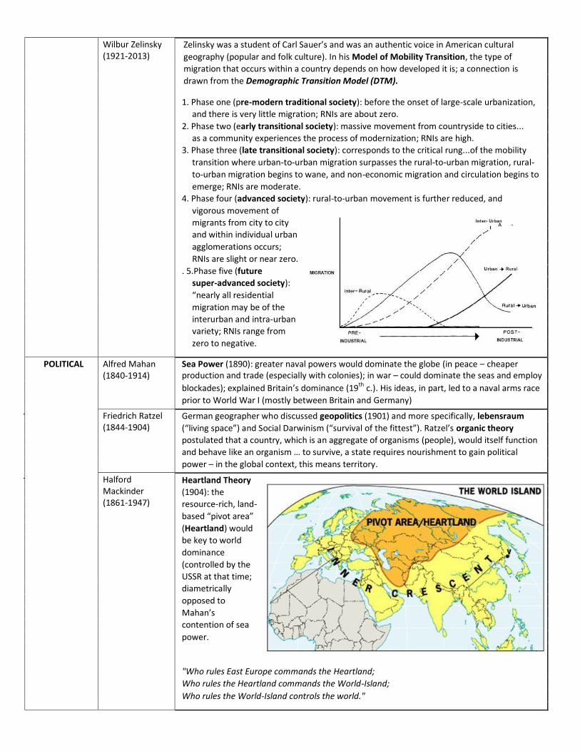
Wilbur Zelinsky (1921-2013)
Zelinsky was a student of Carl Sauer’s and was an authentic voice in American cultural
geography (popular and folk culture). In his Model of Mobility Transition, the type of
migration that occurs within a country depends on how developed it is; a connection is
drawn from the Demographic Transition Model (DTM).
1. Phase one (pre-modern traditional society): before the onset of large-scale urbanization,
and there is very little migration; RNIs are about zero.
2. Phase two (early transitional society): massive movement from countryside to cities...
as a community experiences the process of modernization; RNIs are high.
3. Phase three (late transitional society): corresponds to the critical rung...of the mobility
transition where urban-to-urban migration surpasses the rural-to-urban migration, rural-
to-urban migration begins to wane, and non-economic migration and circulation begins to
emerge; RNIs are moderate.
4. Phase four (advanced society): rural-to-urban movement is further reduced, and
vigorous movement of
migrants from city to city
and within individual urban
agglomerations occurs;
RNIs are slight or near zero.
. 5.Phase five (future
super-advanced society):
“nearly all residential
migration may be of the
interurban and intra-urban
variety; RNIs range from
zero to negative.
POLITICAL Alfred Mahan (1840-1914)
Sea Power (1890): greater naval powers would dominate the globe (in peace – cheaper production and trade (especially with colonies); in war – could dominate the seas and employ
blockades); explained Britain’s dominance (19th c.). His ideas, in part, led to a naval arms race
prior to World War I (mostly between Britain and Germany)
Friedrich Ratzel (1844-1904)
German geographer who discussed geopolitics (1901) and more specifically, lebensraum (“living space”) and Social Darwinism (“survival of the fittest”). Ratzel’s organic theory postulated that a country, which is an aggregate of organisms (people), would itself function and behave like an organism … to survive, a state requires nourishment to gain political power – in the global context, this means territory.
Halford Mackinder (1861-1947)
Heartland Theory (1904): the resource-rich, land- based “pivot area” (Heartland) would be key to world dominance (controlled by the USSR at that time; diametrically opposed to Mahan’s contention of sea power.
"Who rules East Europe commands the Heartland; Who rules the Heartland commands the World-Island; Who rules the World-Island controls the world."
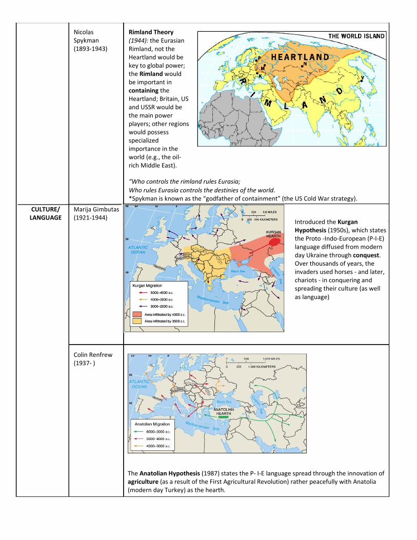
Nicolas Spykman (1893-1943)
CULTURE/ LANGUAGE
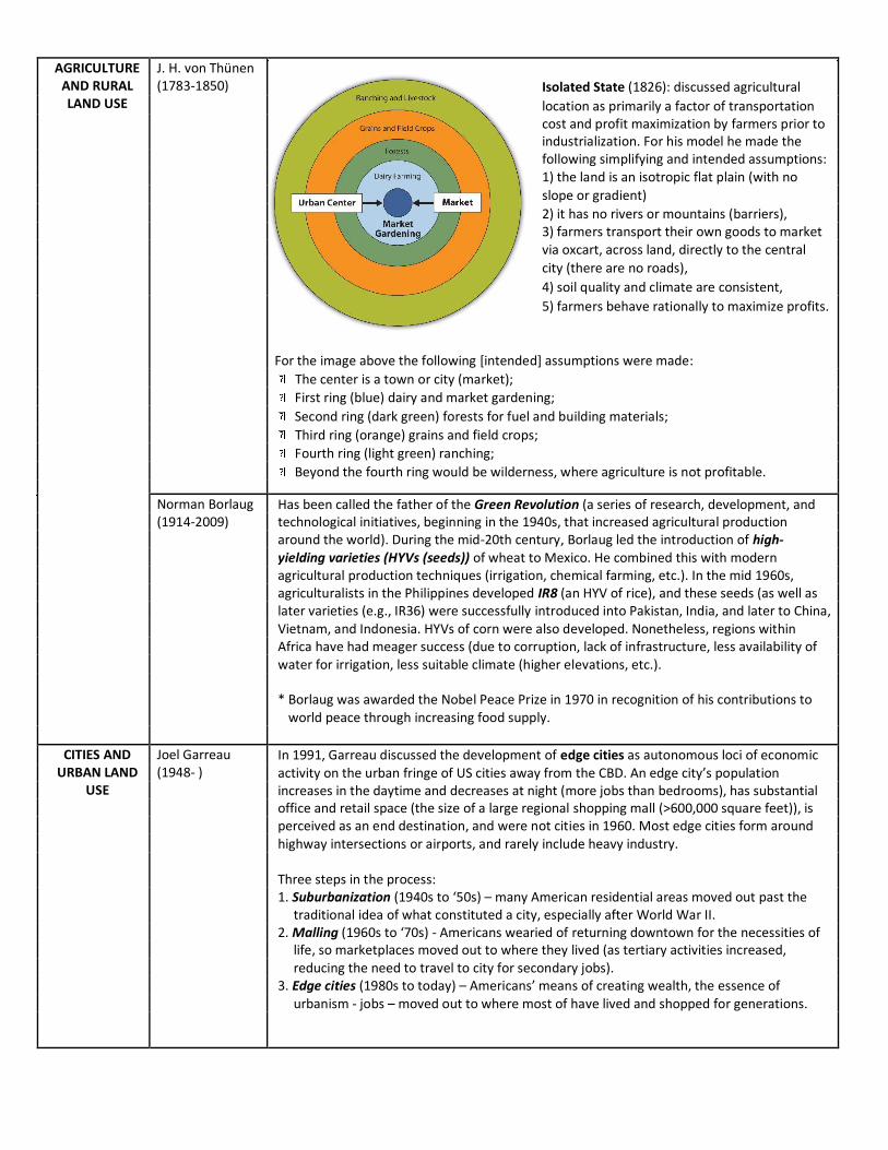
Marija Gimbutas (1921-1944)
Rimland Theory (1944): the Eurasian Rimland, not the Heartland would be key to global power; the Rimland would be important in containing the Heartland; Britain, US and USSR would be the main power players; other regions would possess specialized importance in the world (e.g., the oil-rich Middle East). “Who controls the rimland rules Eurasia; Who rules Eurasia controls the destinies of the world. *Spykman is known as the “godfather of containment” (the US Cold War strategy).
Introduced the Kurgan Hypothesis (1950s), which states the Proto -Indo-European (P-I-E) language diffused from modern day Ukraine through conquest. Over thousands of years, the invaders used horses - and later, chariots - in conquering and spreading their culture (as well as language)
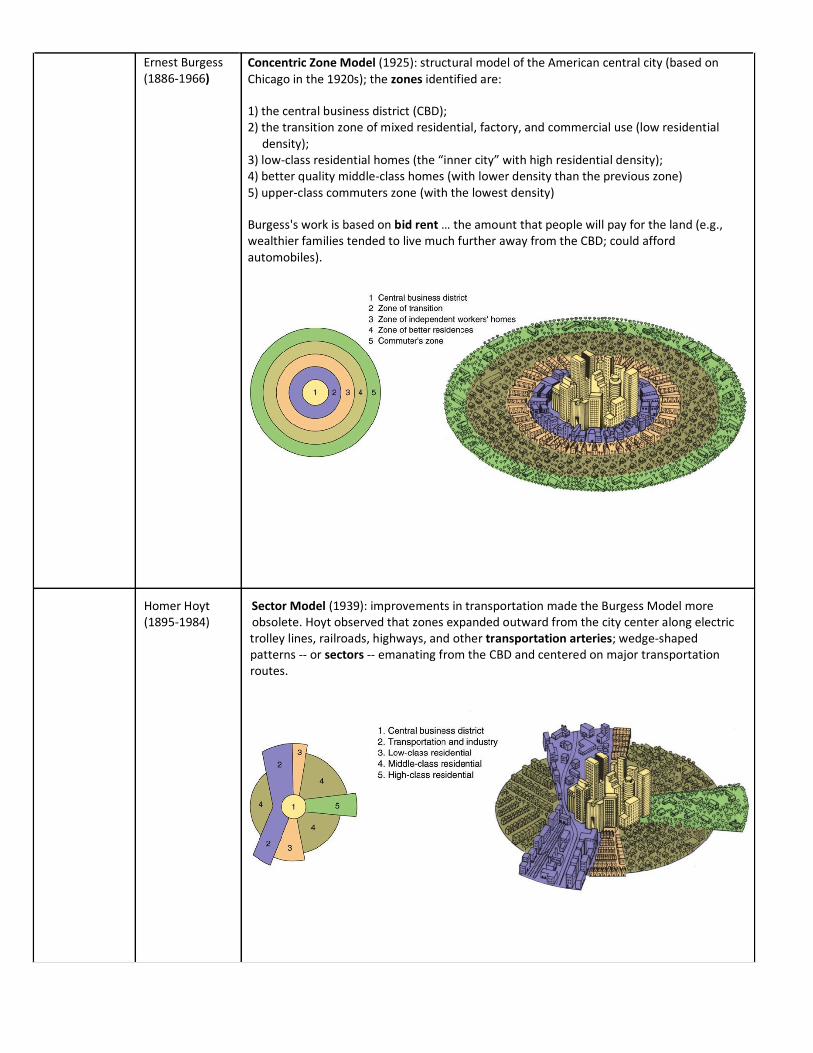
Colin Renfrew (1937- )
The Anatolian Hypothesis (1987) states the P- I-E language spread through the innovation of agriculture (as a result of the First Agricultural Revolution) rather peacefully with Anatolia (modern day Turkey) as the hearth.
AGRICULTURE AND RURAL LAND USE
J. H. von Thünen (1783-1850)
Isolated State (1826): discussed agricultural
location as primarily a factor of transportation cost and profit maximization by farmers prior to industrialization. For his model he made the following simplifying and intended assumptions: 1) the land is an isotropic flat plain (with no
slope or gradient)
2) it has no rivers or mountains (barriers), 3) farmers transport their own goods to market via oxcart, across land, directly to the central
city (there are no roads),
4) soil quality and climate are consistent,
5) farmers behave rationally to maximize profits.
For the image above the following [intended] assumptions were made:
The center is a town or city (market);
First ring (blue) dairy and market gardening;
Second ring (dark green) forests for fuel and building materials;
Third ring (orange) grains and field crops;
Fourth ring (light green) ranching;
Beyond the fourth ring would be wilderness, where agriculture is not profitable.
Norman Borlaug (1914-2009)
Has been called the father of the Green Revolution (a series of research, development, and technological initiatives, beginning in the 1940s, that increased agricultural production around the world). During the mid-20th century, Borlaug led the introduction of high- yielding varieties (HYVs (seeds)) of wheat to Mexico. He combined this with modern agricultural production techniques (irrigation, chemical farming, etc.). In the mid 1960s, agriculturalists in the Philippines developed IR8 (an HYV of rice), and these seeds (as well as later varieties (e.g., IR36) were successfully introduced into Pakistan, India, and later to China, Vietnam, and Indonesia. HYVs of corn were also developed. Nonetheless, regions within Africa have had meager success (due to corruption, lack of infrastructure, less availability of water for irrigation, less suitable climate (higher elevations, etc.).
* Borlaug was awarded the Nobel Peace Prize in 1970 in recognition of his contributions to world peace through increasing food supply.
CITIES AND URBAN LAND
USE
Joel Garreau (1948- )
In 1991, Garreau discussed the development of edge cities as autonomous loci of economic activity on the urban fringe of US cities away from the CBD. An edge city’s population increases in the daytime and decreases at night (more jobs than bedrooms), has substantial office and retail space (the size of a large regional shopping mall (>600,000 square feet)), is perceived as an end destination, and were not cities in 1960. Most edge cities form around highway intersections or airports, and rarely include heavy industry.
Three steps in the process: 1. Suburbanization (1940s to ‘50s) – many American residential areas moved out past the
traditional idea of what constituted a city, especially after World War II. 2. Malling (1960s to ‘70s) - Americans wearied of returning downtown for the necessities of
life, so marketplaces moved out to where they lived (as tertiary activities increased, reducing the need to travel to city for secondary jobs).
3. Edge cities (1980s to today) – Americans’ means of creating wealth, the essence of urbanism - jobs – moved out to where most of have lived and shopped for generations.
Ernest Burgess (1886-1966)
Concentric Zone Model (1925): structural model of the American central city (based on Chicago in the 1920s); the zones identified are:
1) the central business district (CBD); 2) the transition zone of mixed residential, factory, and commercial use (low residential
density); 3) low-class residential homes (the “inner city” with high residential density); 4) better quality middle-class homes (with lower density than the previous zone) 5) upper-class commuters zone (with the lowest density)
Burgess's work is based on bid rent … the amount that people will pay for the land (e.g., wealthier families tended to live much further away from the CBD; could afford automobiles).
Homer Hoyt Sector Model (1939): improvements in transportation made the Burgess Model more (1895-1984) obsolete. Hoyt observed that zones expanded outward from the city center along electric trolley lines, railroads, highways, and other transportation arteries; wedge-shaped patterns -- or sectors -- emanating from the CBD and centered on major transportation routes.
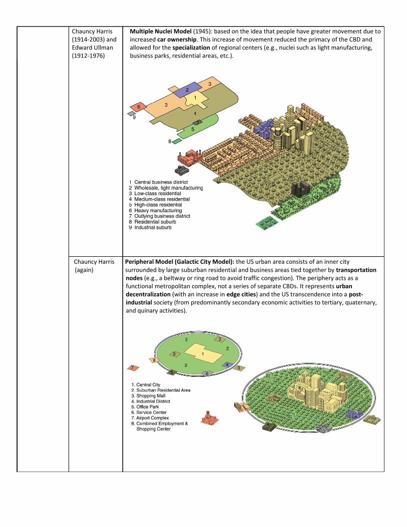
Chauncy Harris (1914-2003) and Edward Ullman (1912-1976)
Multiple Nuclei Model (1945): based on the idea that people have greater movement due to increased car ownership. This increase of movement reduced the primacy of the CBD and allowed for the specialization of regional centers (e.g., nuclei such as light manufacturing, business parks, residential areas, etc.).
Chauncy Harris Peripheral Model (Galactic City Model): the US urban area consists of an inner city
(again) surrounded by large suburban residential and business areas tied together by transportation nodes (e.g., a beltway or ring road to avoid traffic congestion). The periphery acts as a functional metropolitan complex, not a series of separate CBDs. It represents urban decentralization (with an increase in edge cities) and the US transcendence into a post-industrial society (from predominantly secondary economic activities to tertiary, quaternary, and quinary activities).
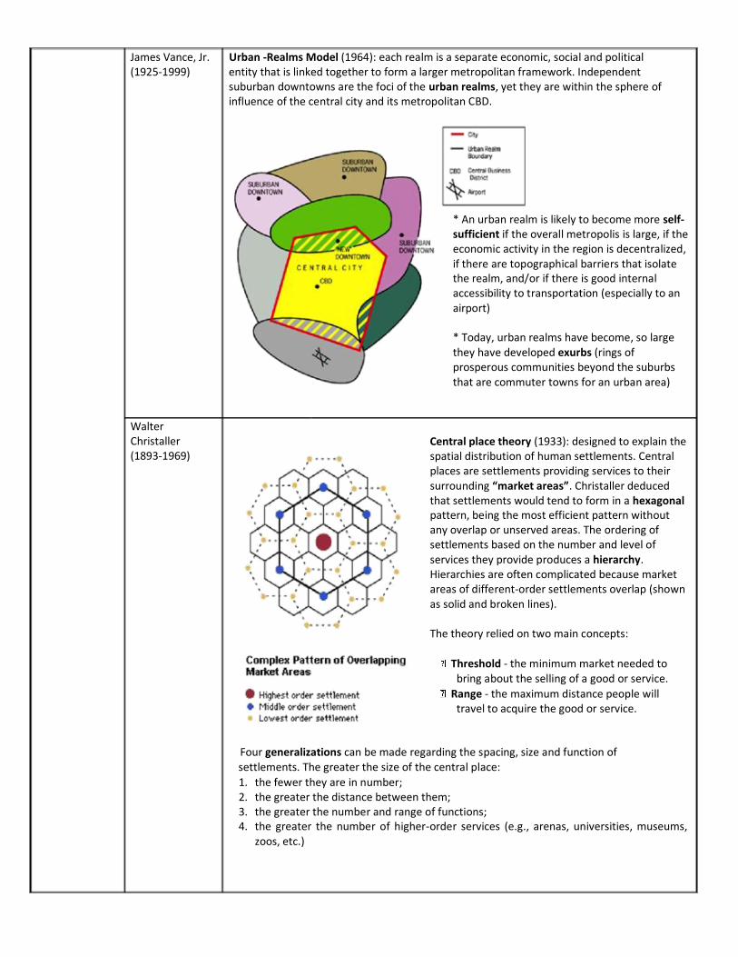
James Vance, Jr. Urban -Realms Model (1964): each realm is a separate economic, social and political (1925-1999) entity that is linked together to form a larger metropolitan framework. Independent
suburban downtowns are the foci of the urban realms, yet they are within the sphere of influence of the central city and its metropolitan CBD.
* An urban realm is likely to become more self-
sufficient if the overall metropolis is large, if the economic activity in the region is decentralized, if there are topographical barriers that isolate the realm, and/or if there is good internal accessibility to transportation (especially to an airport)
* Today, urban realms have become, so large they have developed exurbs (rings of prosperous communities beyond the suburbs that are commuter towns for an urban area)
Walter Christaller (1893-1969)
Central place theory (1933): designed to explain the spatial distribution of human settlements. Central places are settlements providing services to their surrounding “market areas”. Christaller deduced that settlements would tend to form in a hexagonal pattern, being the most efficient pattern without any overlap or unserved areas. The ordering of settlements based on the number and level of services they provide produces a hierarchy. Hierarchies are often complicated because market areas of different-order settlements overlap (shown as solid and broken lines).
The theory relied on two main concepts:
Threshold - the minimum market needed to bring about the selling of a good or service.
Range - the maximum distance people will travel to acquire the good or service.
Four generalizations can be made regarding the spacing, size and function of settlements. The greater the size of the central place:
1. the fewer they are in number; 2. the greater the distance between them; 3. the greater the number and range of functions; 4. the greater the number of higher-order services (e.g., arenas, universities, museums,
zoos, etc.)
John Borchert (1918-2001)
Borchert's epochs (1967): American urbanization can be categorized into four distinct periods, impacted and expanded by a particular transport technology.
The four epochs (plus a fifth) are: 1. Sail-Wagon Epoch (1790–1830) – pre-industrial transportation modes 2. Iron Horse Epoch (1830–1870) - impact of the steam engine; development of steamboats
and regional railroad networks 3. Steel Rail Epoch (1870–1920) - long haul railroads and a national railroad network 4. Auto-Air-Amenity Epoch (1920–1970) - growth in the gasoline-powered internal
combustion engine (automobiles, airplanes) 5. High-Technology Epoch (Satellite-Electronic-Jet Propulsion) (1970-?) – modern technology
has facilitated suburbanization and metropolitan decentralization
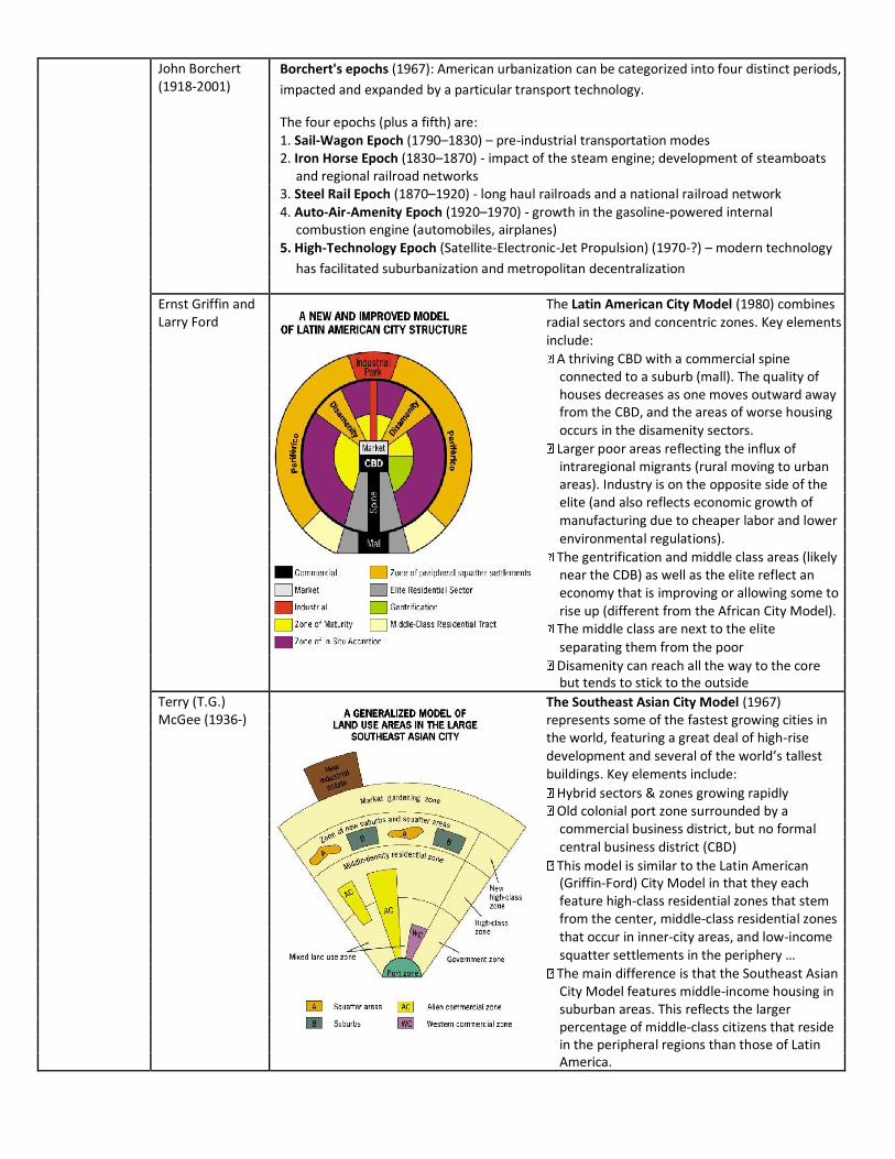
Ernst Griffin and Larry Ford
The Latin American City Model (1980) combines radial sectors and concentric zones. Key elements include:
A thriving CBD with a commercial spine connected to a suburb (mall). The quality of houses decreases as one moves outward away from the CBD, and the areas of worse housing occurs in the disamenity sectors.
Larger poor areas reflecting the influx of intraregional migrants (rural moving to urban areas). Industry is on the opposite side of the elite (and also reflects economic growth of manufacturing due to cheaper labor and lower environmental regulations).
The gentrification and middle class areas (likely near the CDB) as well as the elite reflect an economy that is improving or allowing some to rise up (different from the African City Model).
The middle class are next to the elite separating them from the poor
Disamenity can reach all the way to the core but tends to stick to the outside
Terry (T.G.) McGee (1936-)
The Southeast Asian City Model (1967) represents some of the fastest growing cities in the world, featuring a great deal of high-rise development and several of the world’s tallest buildings. Key elements include:
Hybrid sectors & zones growing rapidly Old colonial port zone surrounded by a commercial business district, but no formal central business district (CBD)
This model is similar to the Latin American (Griffin-Ford) City Model in that they each feature high-class residential zones that stem from the center, middle-class residential zones that occur in inner-city areas, and low-income squatter settlements in the periphery …
The main difference is that the Southeast Asian City Model features middle-income housing in suburban areas. This reflects the larger percentage of middle-class citizens that reside in the peripheral regions than those of Latin America.
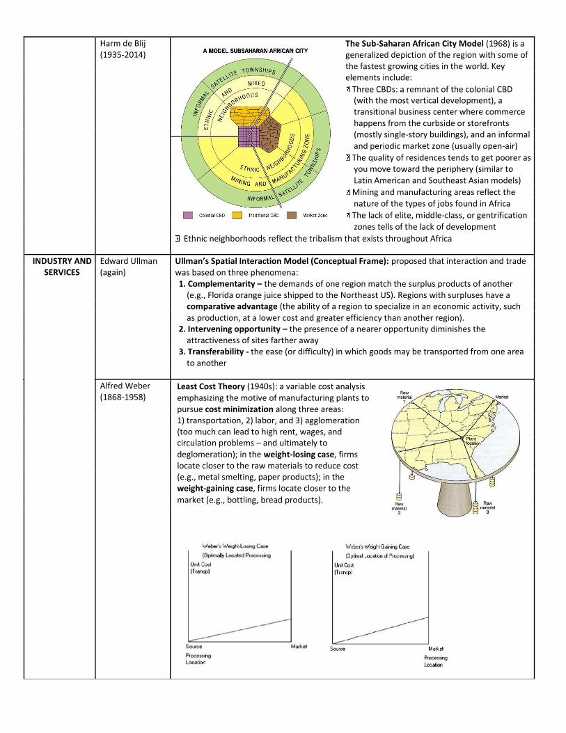
Harm de Blij (1935-2014)
The Sub-Saharan African City Model (1968) is a generalized depiction of the region with some of the fastest growing cities in the world. Key elements include:
Three CBDs: a remnant of the colonial CBD (with the most vertical development), a transitional business center where commerce happens from the curbside or storefronts (mostly single-story buildings), and an informal and periodic market zone (usually open-air)
The quality of residences tends to get poorer as you move toward the periphery (similar to Latin American and Southeast Asian models)
Mining and manufacturing areas reflect the nature of the types of jobs found in Africa
The lack of elite, middle-class, or gentrification zones tells of the lack of development
Ethnic neighborhoods reflect the tribalism that exists throughout Africa
INDUSTRY AND SERVICES
Edward Ullman (again)
Ullman’s Spatial Interaction Model (Conceptual Frame): proposed that interaction and trade was based on three phenomena: 1. Complementarity – the demands of one region match the surplus products of another
(e.g., Florida orange juice shipped to the Northeast US). Regions with surpluses have a comparative advantage (the ability of a region to specialize in an economic activity, such as production, at a lower cost and greater efficiency than another region).
2. Intervening opportunity – the presence of a nearer opportunity diminishes the attractiveness of sites farther away
3. Transferability - the ease (or difficulty) in which goods may be transported from one area to another
Alfred Weber (1868-1958)
Least Cost Theory (1940s): a variable cost analysis emphasizing the motive of manufacturing plants to pursue cost minimization along three areas: 1) transportation, 2) labor, and 3) agglomeration (too much can lead to high rent, wages, and circulation problems – and ultimately to deglomeration); in the weight-losing case, firms locate closer to the raw materials to reduce cost (e.g., metal smelting, paper products); in the weight-gaining case, firms locate closer to the market (e.g., bottling, bread products).
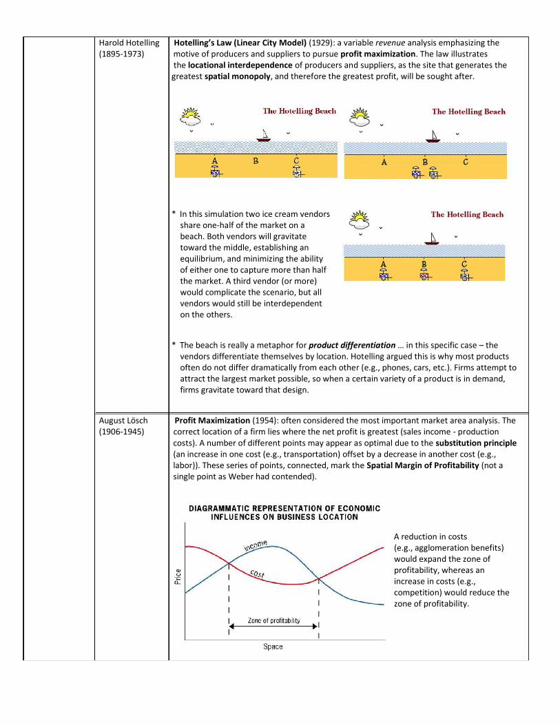
Harold Hotelling Hotelling’s Law (Linear City Model) (1929): a variable revenue analysis emphasizing the (1895-1973) motive of producers and suppliers to pursue profit maximization. The law illustrates
the locational interdependence of producers and suppliers, as the site that generates the greatest spatial monopoly, and therefore the greatest profit, will be sought after.
* In this simulation two ice cream vendors share one-half of the market on a beach. Both vendors will gravitate toward the middle, establishing an equilibrium, and minimizing the ability of either one to capture more than half the market. A third vendor (or more) would complicate the scenario, but all vendors would still be interdependent on the others.
* The beach is really a metaphor for product differentiation … in this specific case – the vendors differentiate themselves by location. Hotelling argued this is why most products often do not differ dramatically from each other (e.g., phones, cars, etc.). Firms attempt to attract the largest market possible, so when a certain variety of a product is in demand, firms gravitate toward that design.
August Lösch Profit Maximization (1954): often considered the most important market area analysis. The (1906-1945) correct location of a firm lies where the net profit is greatest (sales income - production
costs). A number of different points may appear as optimal due to the substitution principle (an increase in one cost (e.g., transportation) offset by a decrease in another cost (e.g., labor)). These series of points, connected, mark the Spatial Margin of Profitability (not a single point as Weber had contended).
A reduction in costs (e.g., agglomeration benefits) would expand the zone of profitability, whereas an increase in costs (e.g., competition) would reduce the zone of profitability.
ECONOMIC DEVELOPMENT
Walter Rostow Modernization Model (1960): the classic liberal model (stating that all states may develop in (1916-2003) the same way); postulates that economic modernization occurs in five stages:
1) Traditional society – economy focuses on mostly subsistence or primary-based activities; society is rigid, negatively viewing change
2) Preconditions for takeoff – development of more productive commercial and cash crops, increased investment and technology; social mobility begins as elite promote change
3) Takeoff – a critical mass of resource exploitation, labor, and capital propel the society toward secondary activities with a few leading industries; export-oriented
4) Drive to Maturity – diversification of industries shift to more domestic
consumption; rapid development of transportation and social infrastructure (e.g., bridges and schools)
5) Age of Mass Consumption - modernization and urbanization diffuses throughout the country; industrialization dominates, but a rise in tertiary (and quaternary and quinary) activities results; most have disposable income beyond basic needs (e.g., automobiles)
Hans Singer (1910-2006) Raúl Prebisch (1901-1986)
Dependency Theory originated with papers by Singer and Prebisch (in 1949) as critiques of the modernization model; it takes a structuralist view (stating that regional disparities are the result of historically derived power relations within the global economic and political system, and therefore cannot be changed easily). The export-driven economies of developing countries (trading mostly raw materials and commodities that have declined in value as compared with manufactured goods) limit the development possibilities of poorer areas; this dependency helps sustain the prosperity of richer regions, even after decolonization had occurred (neocolonialism).
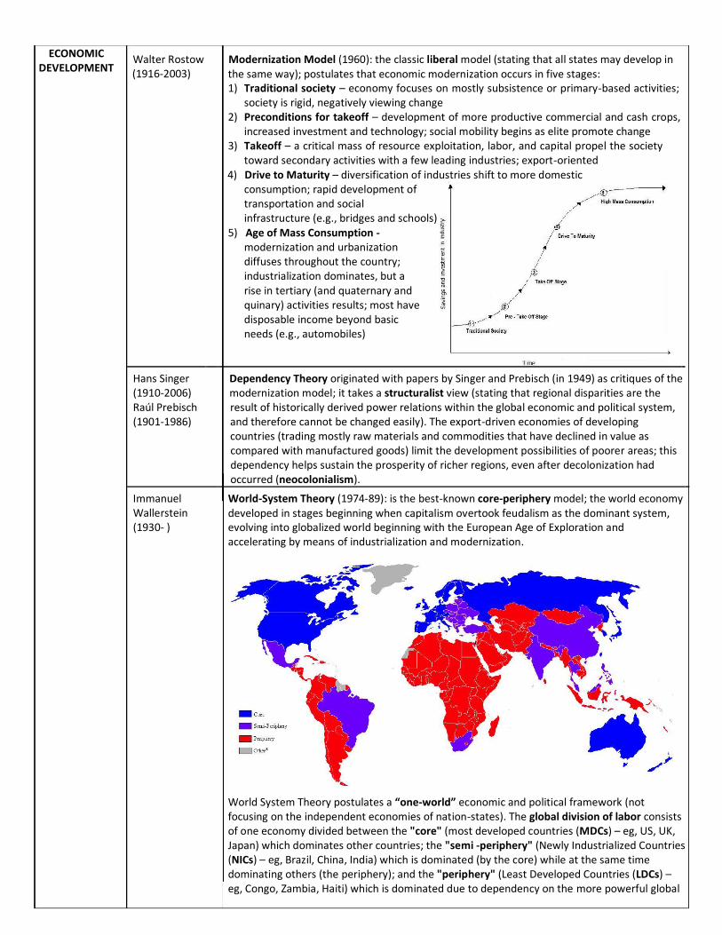
Immanuel Wallerstein (1930- )
World-System Theory (1974-89): is the best-known core-periphery model; the world economy developed in stages beginning when capitalism overtook feudalism as the dominant system, evolving into globalized world beginning with the European Age of Exploration and accelerating by means of industrialization and modernization.
World System Theory postulates a “one-world” economic and political framework (not focusing on the independent economies of nation-states). The global division of labor consists of one economy divided between the "core" (most developed countries (MDCs) – eg, US, UK, Japan) which dominates other countries; the "semi -periphery" (Newly Industrialized Countries (NICs) – eg, Brazil, China, India) which is dominated (by the core) while at the same time dominating others (the periphery); and the "periphery" (Least Developed Countries (LDCs) – eg, Congo, Zambia, Haiti) which is dominated due to dependency on the more powerful global