Embed Size (px)
Citation preview

Geographic Information CouncilFramework Subcommittee
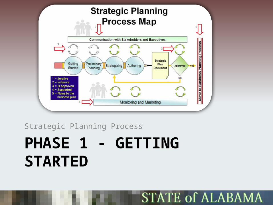
PHASE 1 - GETTING STARTEDStrategic Planning Process
Alabama Strategic PlanFramework Data
• Focus Area - How can we better assess all current geospatial information available in the state and make recommendations to reduce inefficiency and redundancy in geospatial information collection?
• Identification of data layer types– Goal 1 – Establish a Technical Subcommittee on Framework
Data– Goal 2 – Fulfill the objectives of the NSDI framework strategy
and State’s priority needs– Goal 3 – Identify gaps in the data inventory and prioritize needs

Alabama Strategic PlanData Categories
• Priority data layers– Framework data layers - Digital Ortho imagery, Cadastral Data, Geodetic Control,
Elevation, Transportation, Governmental Units (political boundaries), and Hydrography
• Additional data layers as identified by the State consist of data in the following categories:– Locational data layers - police, fire, ambulance, critical infrastructure, schools,
hospitals, aged care, community centers, key buildings, sports facilities, etc.
– Infrastructure layers - Electricity, substations, gas, water, hydrants, sewerage, storm water, telecoms, radios, towers, etc.
– Dynamic or derivative data layers - Demography, employment, valuations, public transport schedules, pedestrians, floor plans, hazards models, cameras, radar, tracking, weather, etc.
– Historic Data - Provide guidelines and recommendations on procedures for the capture, archiving, and retrieval of pertinent historic information.
Goal 1 – Establish a Technical Subcommittee on Framework Data
• Goal 1 Establish subcommittee for Framework and Ancillary Data issues.– Strategy: Solicit recommendations from the Advisory Committee members for
individuals to serve on the Subcommittee to address issues associated with Framework and other priority data.
– Measure: A subcommittee is established and begins its work.
– Timeline: June 2010
• Generally completed– A Subcommittee has been established and we need to ensure that we have proper
representation and stakeholders
• Regular meeting time • 3rd Wednesday of every month @ 10AM Central• Meeting will be held online through the ISD - Alabama Web Connect conferencing tool
Goal 2 – Fulfill the objectives of the NSDI framework strategy and State’s priority needs
• Goal 2 Establish mechanisms to measure the state’s progress with regard to fulfilling the objectives of the National Spatial Data Infrastructure (NSDI) framework, as well as the state’s other priority data needs.
– Strategy: Inventory the existing framework and ancillary data holdings and compilation of inventory results.
– Measure: Record status of framework data’s NSDI suitability in the state inventory holdings list.
– Timeline: All State agencies shall complete reporting of data suitable for inclusion into the NSDI by December 1, 2010 and all county and local governments shall be completed by June 1, 2011.
– Strategy: Increase participation in NSDI framework data activities.
– Measure: Build data sharing environments through partnerships across the state, follow data and operating standards, formulate templates for framework development where applicable.
– Timeline: Ongoing

Goal 3 – Identify gaps in the data inventory and prioritize needs
• Goal 3 Gaps in the data inventory will be identified throughout the process of goals 1, 2, and 3 and identified needs will be prioritized.
– Strategy: Identify data through survey and needs assessment across the state and cross-reference them to the state data holdings, identifying incomplete or unavailable data that are needed by the widest audience and are of the greatest utility to data consumers.
– Measure: Completion of data survey and needs assessment, completion of the data holdings inventory, and presentation to the Council (e.g., Centerline project, 9-1-1 addressing, updated imagery, better resolution elevation data, etc).
– Timeline: July 2012.
– Strategy: Once data surveys and needs assessments have been completed, the council shall rank needs based on criteria to be established.
– Measure: Completion of prioritized needs published to the web.
– Timeline: July 2012.

GIS Inventory
• September 22, 2010 – Bill Bugess, NSGIC presented the GIS Inventory to the Framework Data Subcommittee.
• The committee reviewed use, capabilities, and functionality of the tool. http://al.gisinventory.net
• The committee had unanimous consent to recommend to the Advisory Committee the use of GIS Inventory to:– Assist in the capture of an Alabama GIS Inventory– Serve as the primary inventory tool in implementation of Framework
Data section of the Strategic Plan, • satisfying Goal 2 of Framework Data.