Embed Size (px)
Citation preview
Geographic Information
Retrieval
Danilo Montesi
Yisleidy Linares Zaila
Outline
1. Introduction
• Geographic Information Retrieval (GIR): basic concepts
• General architecture
2. Geographic Indexes
• Separate Index
• Hybrid Index
• Use of R-tree structure
3. GIR resources
• Gazetteers
• Geographic ontologies
4. Geographic Information Extraction
• Toponym Recognition
• Toponym Disambiguation
5. Geographic Data Representation
• Geographic coordinates
• Minimum Bounding Rectangle
Outline
6. Query Processing
• Query Expansion
7. Geographic Similarity Measures
• Euclidean distance
• Topological relationship
8. Textual and Geographic Rankings
• First textual, after geographic or vice-versa
• Linear combination
9. GIR evaluation
• GeoCLEF test collections
• Evaluation Measures
10. IR frameworks
• Terrier
11. Current challenges
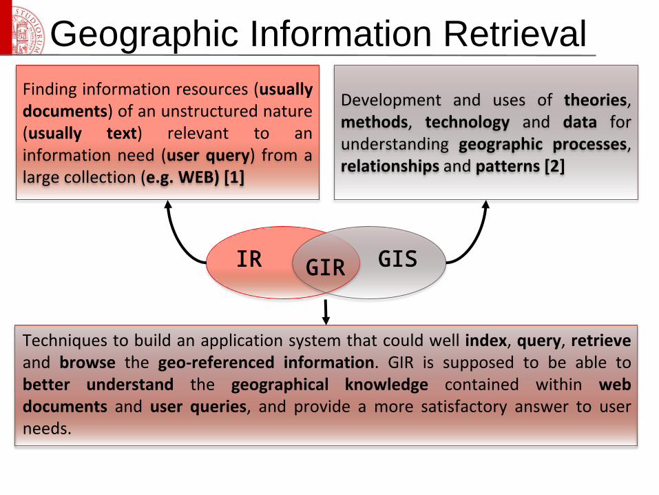
Geographic Information Retrieval
IR GIR GIS
Finding information resources (usuallydocuments) of an unstructured nature(usually text) relevant to aninformation need (user query) from alarge collection (e.g. WEB) [1]
Development and uses of theories,methods, technology and data forunderstanding geographic processes,relationships and patterns [2]
Techniques to build an application system that could well index, query, retrieveand browse the geo-referenced information. GIR is supposed to be able tobetter understand the geographical knowledge contained within webdocuments and user queries, and provide a more satisfactory answer to userneeds.
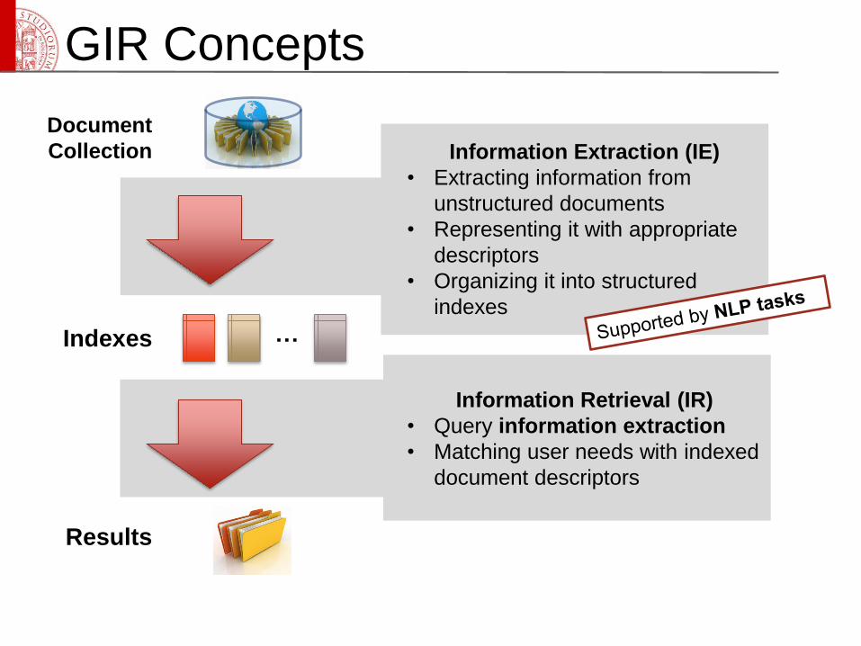
GIR Concepts
Document
Collection
Indexes …
Results
Information Extraction (IE)
• Extracting information from
unstructured documents
• Representing it with appropriate
descriptors
• Organizing it into structured
indexes
Information Retrieval (IR)
• Query information extraction
• Matching user needs with indexed
document descriptors
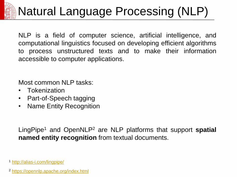
Natural Language Processing (NLP)
NLP is a field of computer science, artificial intelligence, and
computational linguistics focused on developing efficient algorithms
to process unstructured texts and to make their information
accessible to computer applications.
Most common NLP tasks:
• Tokenization
• Part-of-Speech tagging
• Name Entity Recognition
LingPipe1 and OpenNLP2 are NLP platforms that support spatial
named entity recognition from textual documents.
1 http://alias-i.com/lingpipe/
2 https://opennlp.apache.org/index.html
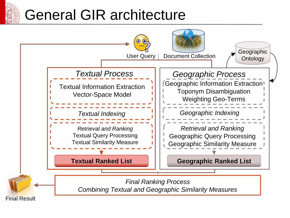
General GIR architecture
Textual Process
Textual Information Extraction
Vector-Space Model
Retrieval and Ranking
Textual Query Processing
Textual Similarity Measure
Textual Indexing
Textual Ranked List
Geographic ProcessGeographic Information Extraction
Toponym Disambiguation
Weighting Geo-Terms
Geographic Indexing
Retrieval and Ranking
Geographic Query Processing
Geographic Similarity Measure
Geographic Ranked List
Geographic
Ontology
Final Ranking Process
Combining Textual and Geographic Similarity Measures
User Query Document Collection
Final Result
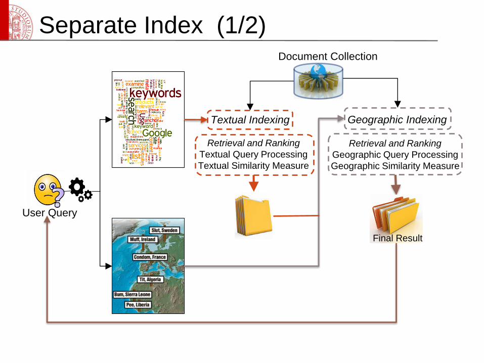
Separate Index (1/2)
Textual Indexing Geographic Indexing
Retrieval and Ranking
Textual Query Processing
Textual Similarity Measure
Retrieval and Ranking
Geographic Query Processing
Geographic Similarity Measure
Final Result
User Query
Document Collection
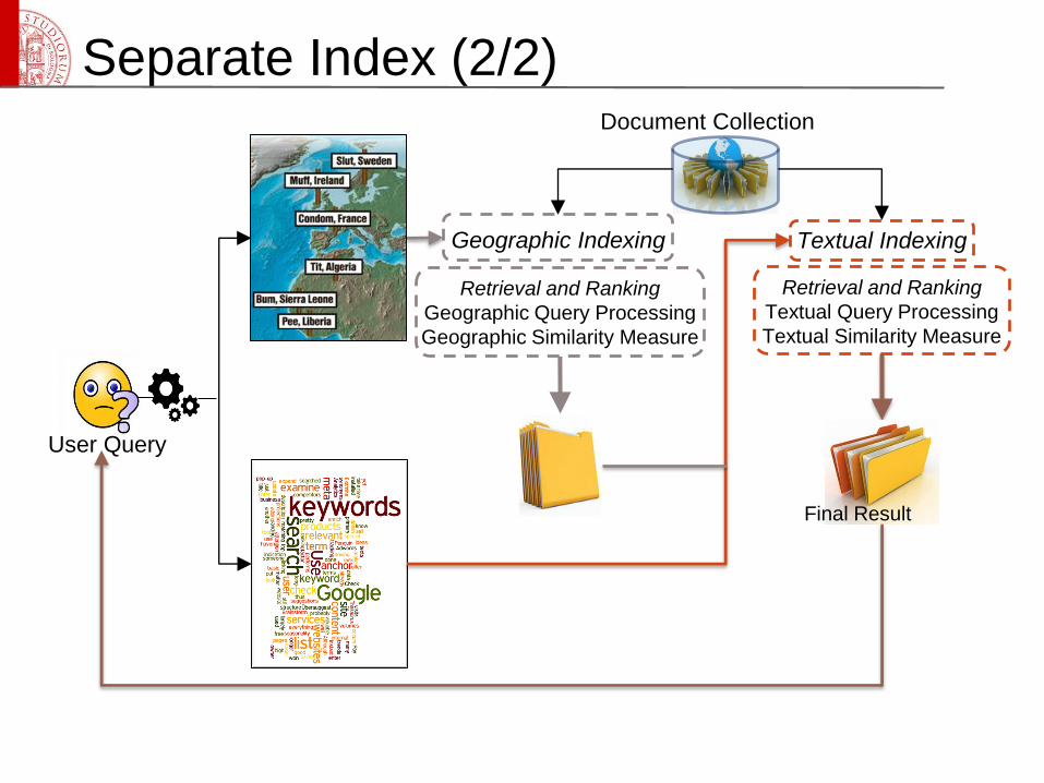
Separate Index (2/2)
Textual IndexingGeographic Indexing
Retrieval and Ranking
Textual Query Processing
Textual Similarity Measure
Retrieval and Ranking
Geographic Query Processing
Geographic Similarity Measure
Final Result
User Query
Document Collection
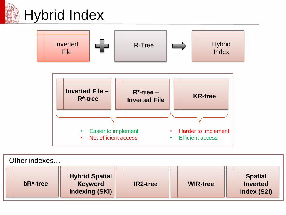
Hybrid Index
Inverted
FileR-Tree Hybrid
Index
Inverted File –
R*-treeR*-tree –
Inverted FileKR-tree
• Easier to implement
• Not efficient access
• Harder to implement
• Efficient access
Spatial
Inverted
Index (S2I)
Hybrid Spatial
Keyword
Indexing (SKI)
bR*-tree IR2-tree WIR-tree
Other indexes…
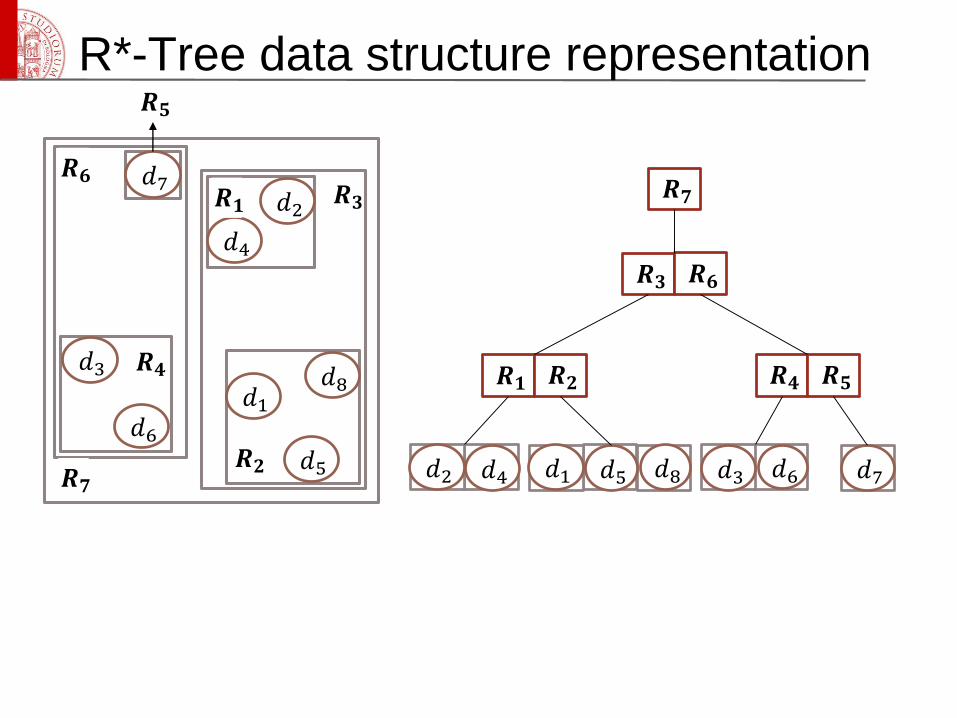
R*-Tree data structure representation
𝑑2
𝑑4
𝑑3
𝑑6
𝑑7
𝑑1
𝑑5
𝑑8
𝑹𝟑
𝑹𝟐
𝑹𝟏
𝑹𝟒
𝑹𝟓
𝑹𝟔
𝑹𝟕𝑑1𝑑2 𝑑3𝑑4 𝑑5 𝑑6 𝑑7𝑑8
𝑹𝟑 𝑹𝟔
𝑹𝟏 𝑹𝟐 𝑹𝟒 𝑹𝟓
𝑹𝟕
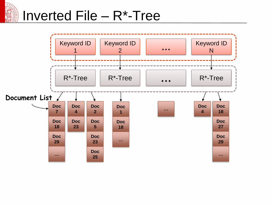
Document List
Inverted File – R*-Tree
Keyword ID
1
Keyword ID
2
Keyword ID
N…
R*-Tree R*-Tree R*-Tree…
Doc
7
Doc
18
Doc
29
…
Doc
4
Doc
23
…Doc
2
Doc
5
Doc
23
Doc
25
Doc
1
Doc
18
…
Doc
4
Doc
18
Doc
27
Doc
29
…
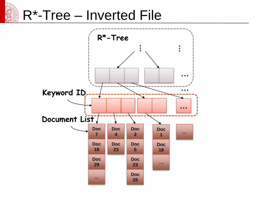
Keyword ID
⋮
⋯
⋮R*-Tree
Document List
R*-Tree – Inverted File
…
Doc
7
Doc
18
Doc
29
…
Doc
4
Doc
23
…Doc
2
Doc
5
Doc
23
Doc
25
Doc
1
Doc
18
…
⋯
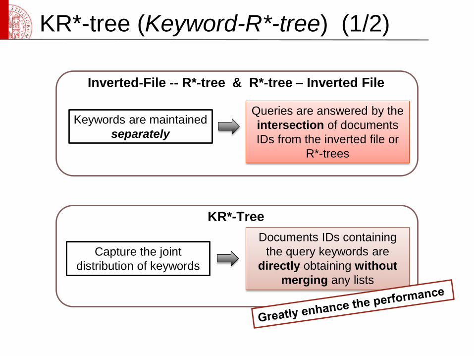
KR*-tree (Keyword-R*-tree) (1/2)
Keywords are maintained
separately
Queries are answered by the
intersection of documents
IDs from the inverted file or
R*-trees
Inverted-File -- R*-tree & R*-tree – Inverted File
Capture the joint
distribution of keywords
Documents IDs containing
the query keywords are
directly obtaining without
merging any lists
KR*-Tree
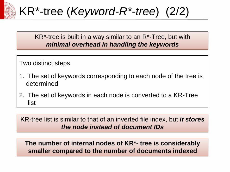
KR*-tree (Keyword-R*-tree) (2/2)
Two distinct steps
1. The set of keywords corresponding to each node of the tree is
determined
2. The set of keywords in each node is converted to a KR-Tree
list
KR*-tree is built in a way similar to an R*-Tree, but with
minimal overhead in handling the keywords
KR-tree list is similar to that of an inverted file index, but it stores
the node instead of document IDs
The number of internal nodes of KR*- tree is considerably
smaller compared to the number of documents indexed
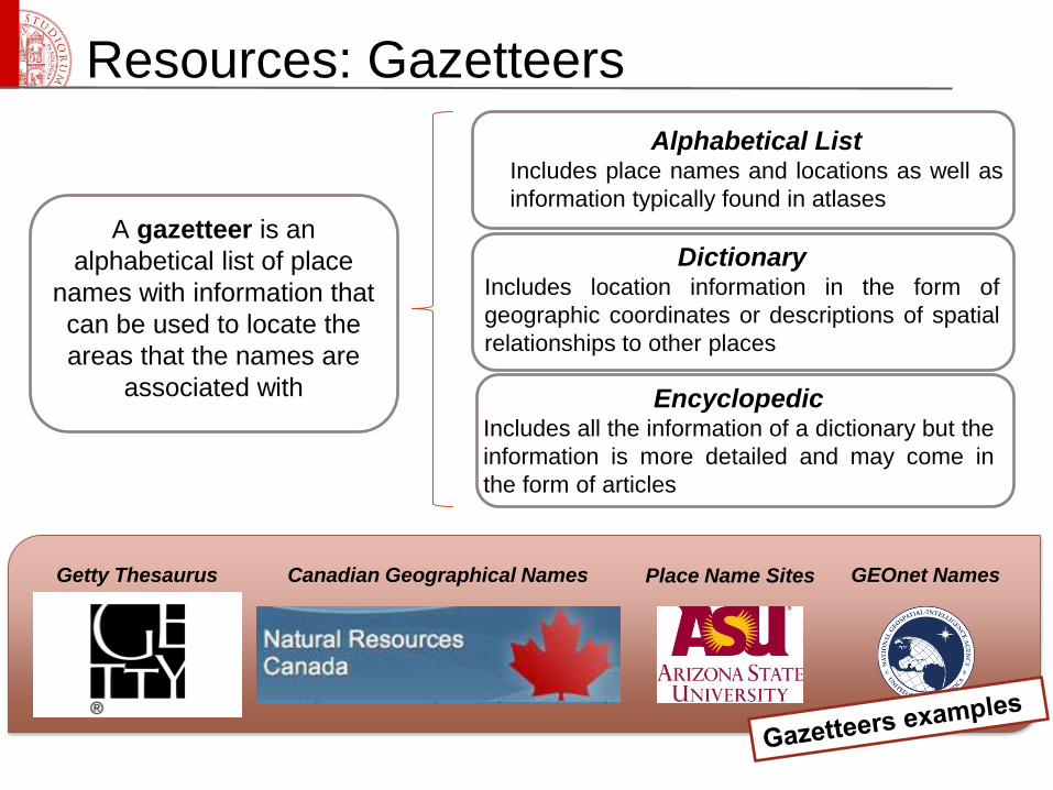
Resources: Gazetteers
A gazetteer is an
alphabetical list of place
names with information that
can be used to locate the
areas that the names are
associated with
Alphabetical ListIncludes place names and locations as well as
information typically found in atlases
DictionaryIncludes location information in the form of
geographic coordinates or descriptions of spatial
relationships to other places
EncyclopedicIncludes all the information of a dictionary but the
information is more detailed and may come in
the form of articles
Place Name SitesCanadian Geographical NamesGetty Thesaurus GEOnet Names
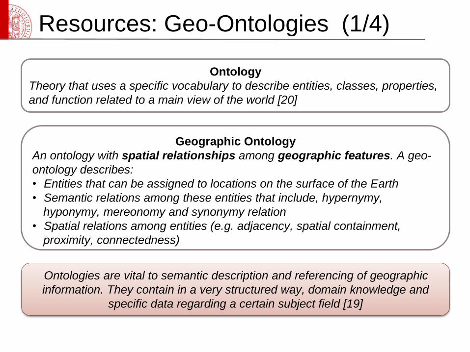
Resources: Geo-Ontologies (1/4)
Ontology
Theory that uses a specific vocabulary to describe entities, classes, properties,
and function related to a main view of the world [20]
Geographic Ontology
An ontology with spatial relationships among geographic features. A geo-
ontology describes:
• Entities that can be assigned to locations on the surface of the Earth
• Semantic relations among these entities that include, hypernymy,
hyponymy, mereonomy and synonymy relation
• Spatial relations among entities (e.g. adjacency, spatial containment,
proximity, connectedness)
Ontologies are vital to semantic description and referencing of geographic
information. They contain in a very structured way, domain knowledge and
specific data regarding a certain subject field [19]
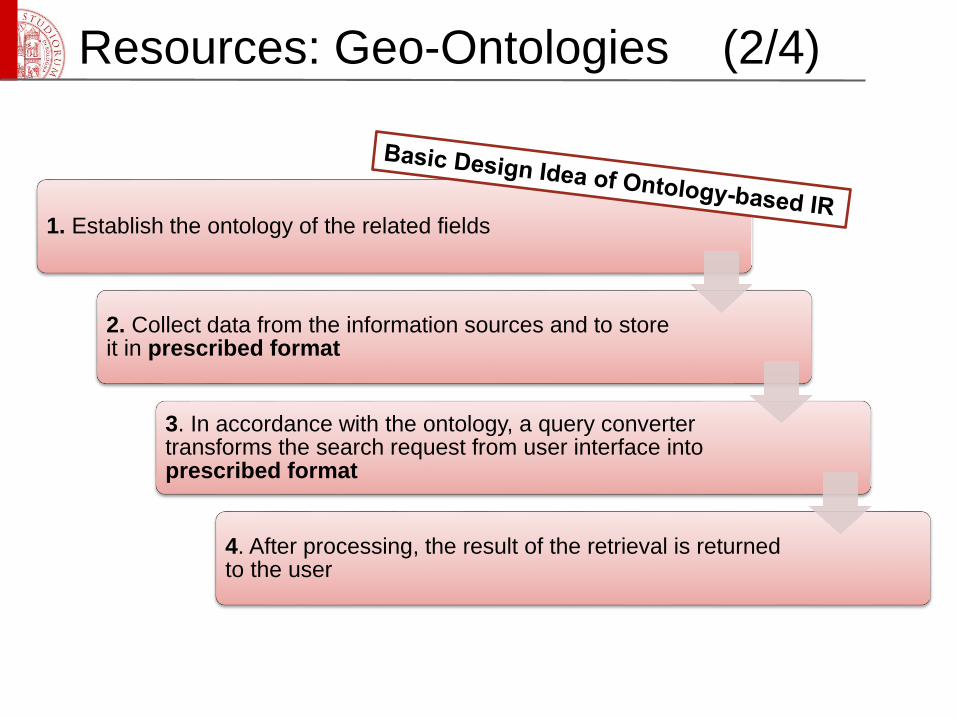
Resources: Geo-Ontologies (2/4)
1. Establish the ontology of the related fields
2. Collect data from the information sources and to store it in prescribed format
3. In accordance with the ontology, a query converter transforms the search request from user interface into prescribed format
4. After processing, the result of the retrieval is returned to the user
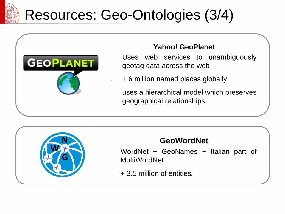
Resources: Geo-Ontologies (3/4)
Yahoo! GeoPlanet
• Uses web services to unambiguously
geotag data across the web
• + 6 million named places globally
• uses a hierarchical model which preserves
geographical relationships
GeoWordNet
• WordNet + GeoNames + Italian part of
MultiWordNet
• + 3.5 million of entities.
Resources: Geo-Ontologies (4/4)
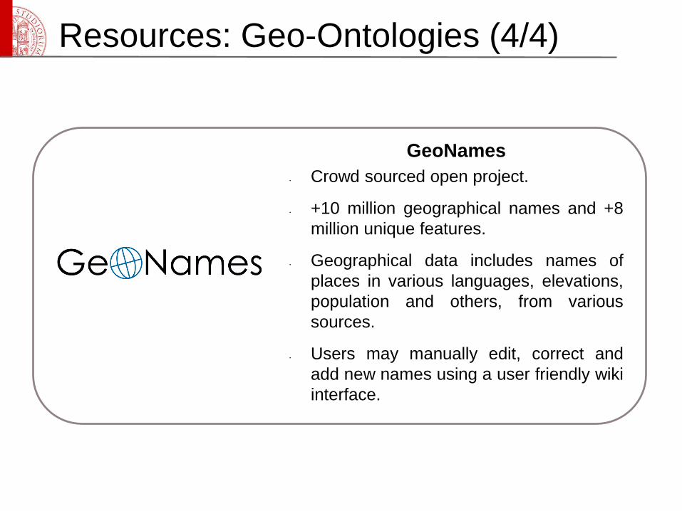
GeoNames
• Crowd sourced open project.
• +10 million geographical names and +8
million unique features.
• Geographical data includes names of
places in various languages, elevations,
population and others, from various
sources.
• Users may manually edit, correct and
add new names using a user friendly wiki
interface.
Geographic Information Extraction (1/6)
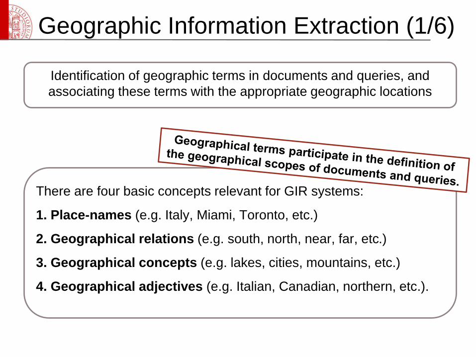
Identification of geographic terms in documents and queries, and
associating these terms with the appropriate geographic locations
There are four basic concepts relevant for GIR systems:
1. Place-names (e.g. Italy, Miami, Toronto, etc.)
2. Geographical relations (e.g. south, north, near, far, etc.)
3. Geographical concepts (e.g. lakes, cities, mountains, etc.)
4. Geographical adjectives (e.g. Italian, Canadian, northern, etc.).
Geographic Information Extraction (2/6)
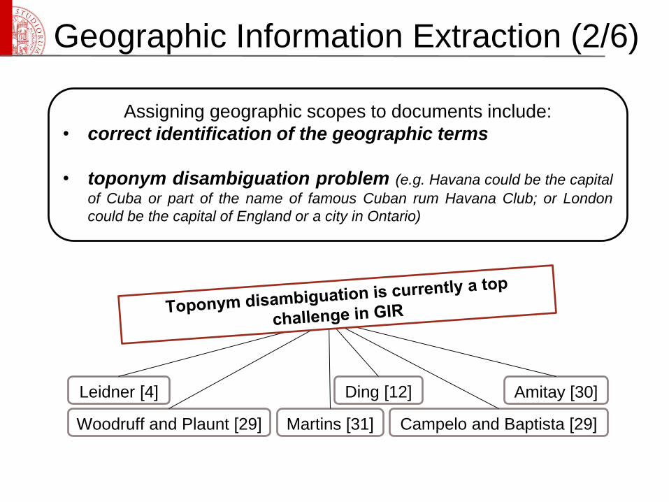
Woodruff and Plaunt [29]
Leidner [4] Ding [12] Amitay [30]
Martins [31] Campelo and Baptista [29]
Assigning geographic scopes to documents include:
• correct identification of the geographic terms
• toponym disambiguation problem (e.g. Havana could be the capital
of Cuba or part of the name of famous Cuban rum Havana Club; or London
could be the capital of England or a city in Ontario)
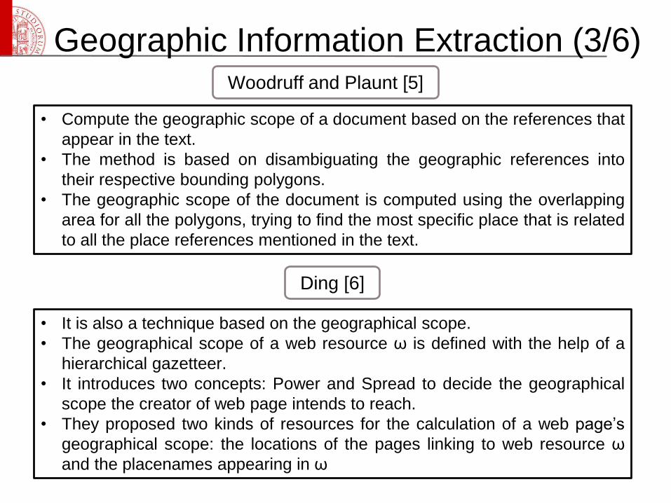
Geographic Information Extraction (3/6)
• Compute the geographic scope of a document based on the references that
appear in the text.
• The method is based on disambiguating the geographic references into
their respective bounding polygons.
• The geographic scope of the document is computed using the overlapping
area for all the polygons, trying to find the most specific place that is related
to all the place references mentioned in the text.
Woodruff and Plaunt [5]
Ding [6]
• It is also a technique based on the geographical scope.
• The geographical scope of a web resource ω is defined with the help of a
hierarchical gazetteer.
• It introduces two concepts: Power and Spread to decide the geographical
scope the creator of web page intends to reach.
• They proposed two kinds of resources for the calculation of a web page’s
geographical scope: the locations of the pages linking to web resource ω
and the placenames appearing in ω
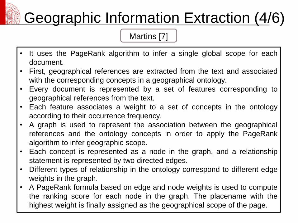
Geographic Information Extraction (4/6)
• It uses the PageRank algorithm to infer a single global scope for each
document.
• First, geographical references are extracted from the text and associated
with the corresponding concepts in a geographical ontology.
• Every document is represented by a set of features corresponding to
geographical references from the text.
• Each feature associates a weight to a set of concepts in the ontology
according to their occurrence frequency.
• A graph is used to represent the association between the geographical
references and the ontology concepts in order to apply the PageRank
algorithm to infer geographic scope.
• Each concept is represented as a node in the graph, and a relationship
statement is represented by two directed edges.
• Different types of relationship in the ontology correspond to different edge
weights in the graph.
• A PageRank formula based on edge and node weights is used to compute
the ranking score for each node in the graph. The placename with the
highest weight is finally assigned as the geographical scope of the page.
Martins [7]
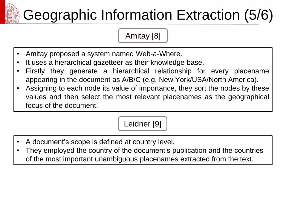
Geographic Information Extraction (5/6)
• Amitay proposed a system named Web-a-Where.
• It uses a hierarchical gazetteer as their knowledge base.
• Firstly they generate a hierarchical relationship for every placename
appearing in the document as A/B/C (e.g. New York/USA/North America).
• Assigning to each node its value of importance, they sort the nodes by these
values and then select the most relevant placenames as the geographical
focus of the document.
Amitay [8]
• A document’s scope is defined at country level.
• They employed the country of the document’s publication and the countries
of the most important unambiguous placenames extracted from the text.
Leidner [9]
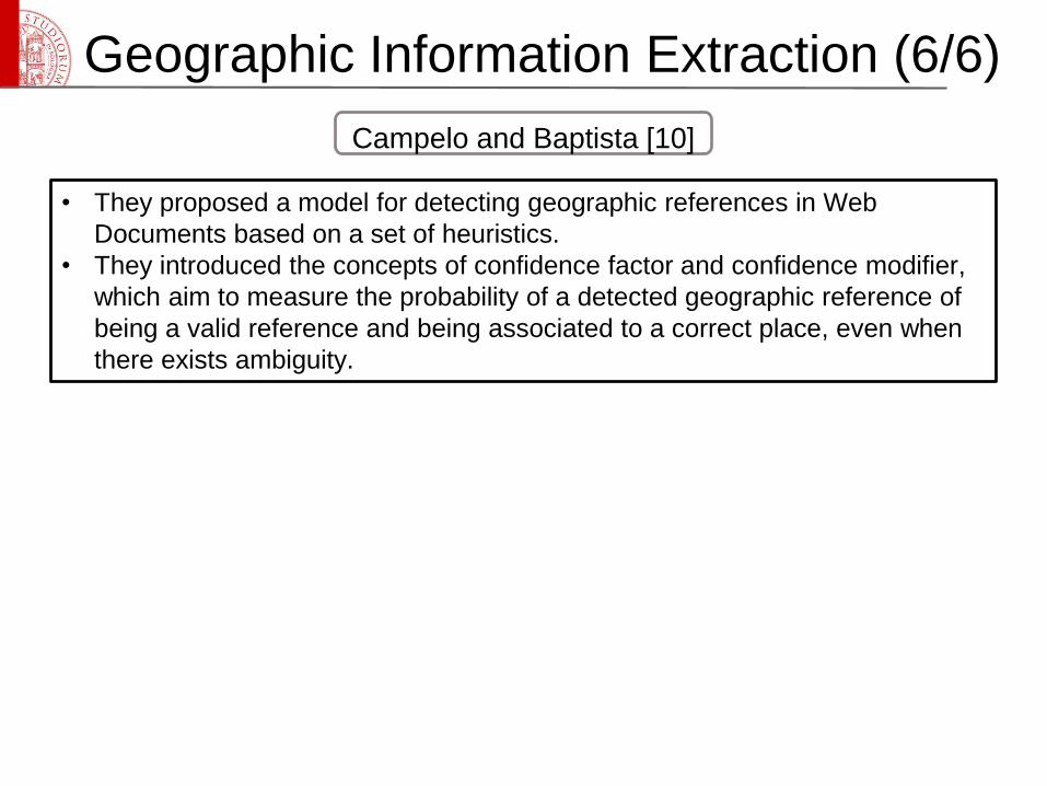
Geographic Information Extraction (6/6)
• They proposed a model for detecting geographic references in Web
Documents based on a set of heuristics.
• They introduced the concepts of confidence factor and confidence modifier,
which aim to measure the probability of a detected geographic reference of
being a valid reference and being associated to a correct place, even when
there exists ambiguity.
Campelo and Baptista [10]
Query Processing (1/2)
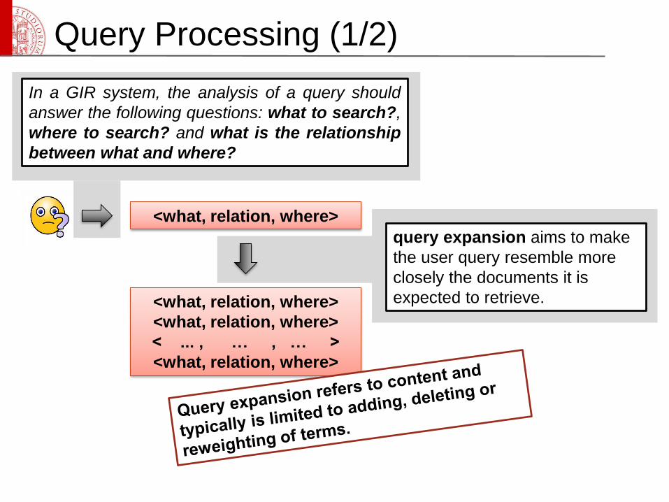
In a GIR system, the analysis of a query should
answer the following questions: what to search?,
where to search? and what is the relationship
between what and where?
query expansion aims to make
the user query resemble more
closely the documents it is
expected to retrieve.
<what, relation, where>
<what, relation, where>
<what, relation, where>
< ... , … , … >
<what, relation, where>
Query Processing (2/2)
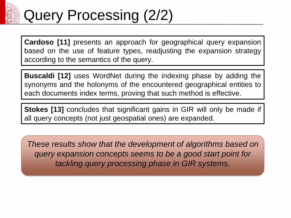
Cardoso [11] presents an approach for geographical query expansion
based on the use of feature types, readjusting the expansion strategy
according to the semantics of the query.
Buscaldi [12] uses WordNet during the indexing phase by adding the
synonyms and the holonyms of the encountered geographical entities to
each documents index terms, proving that such method is effective.
Stokes [13] concludes that significant gains in GIR will only be made if
all query concepts (not just geospatial ones) are expanded.
These results show that the development of algorithms based on
query expansion concepts seems to be a good start point for
tackling query processing phase in GIR systems.
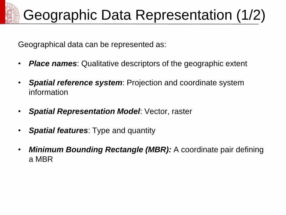
Geographic Data Representation (1/2)
Geographical data can be represented as:
• Place names: Qualitative descriptors of the geographic extent
• Spatial reference system: Projection and coordinate system
information
• Spatial Representation Model: Vector, raster
• Spatial features: Type and quantity
• Minimum Bounding Rectangle (MBR): A coordinate pair defining
a MBR
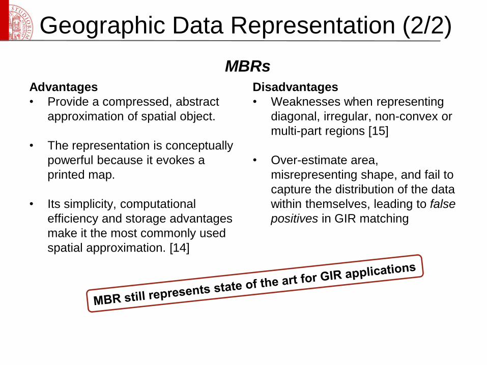
Advantages
• Provide a compressed, abstract
approximation of spatial object.
• The representation is conceptually
powerful because it evokes a
printed map.
• Its simplicity, computational
efficiency and storage advantages
make it the most commonly used
spatial approximation. [14]
Disadvantages
• Weaknesses when representing
diagonal, irregular, non-convex or
multi-part regions [15]
• Over-estimate area,
misrepresenting shape, and fail to
capture the distribution of the data
within themselves, leading to false
positives in GIR matching
Geographic Data Representation (2/2)
MBRs
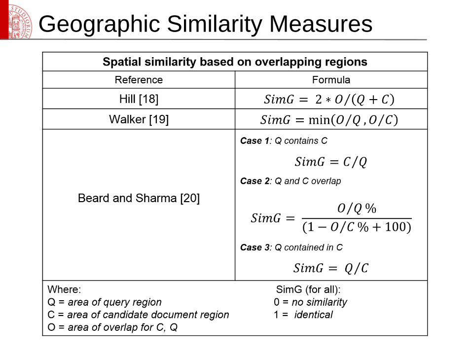
Geographic Similarity Measures
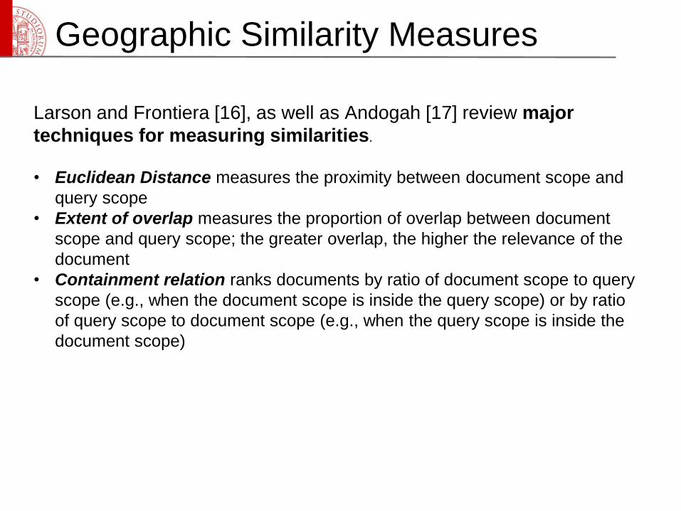
Larson and Frontiera [16], as well as Andogah [17] review major
techniques for measuring similarities.
• Euclidean Distance measures the proximity between document scope and
query scope
• Extent of overlap measures the proportion of overlap between document
scope and query scope; the greater overlap, the higher the relevance of the
document
• Containment relation ranks documents by ratio of document scope to query
scope (e.g., when the document scope is inside the query scope) or by ratio
of query scope to document scope (e.g., when the query scope is inside the
document scope)
Geographic Similarity Measures
Geographic Similarity Measures
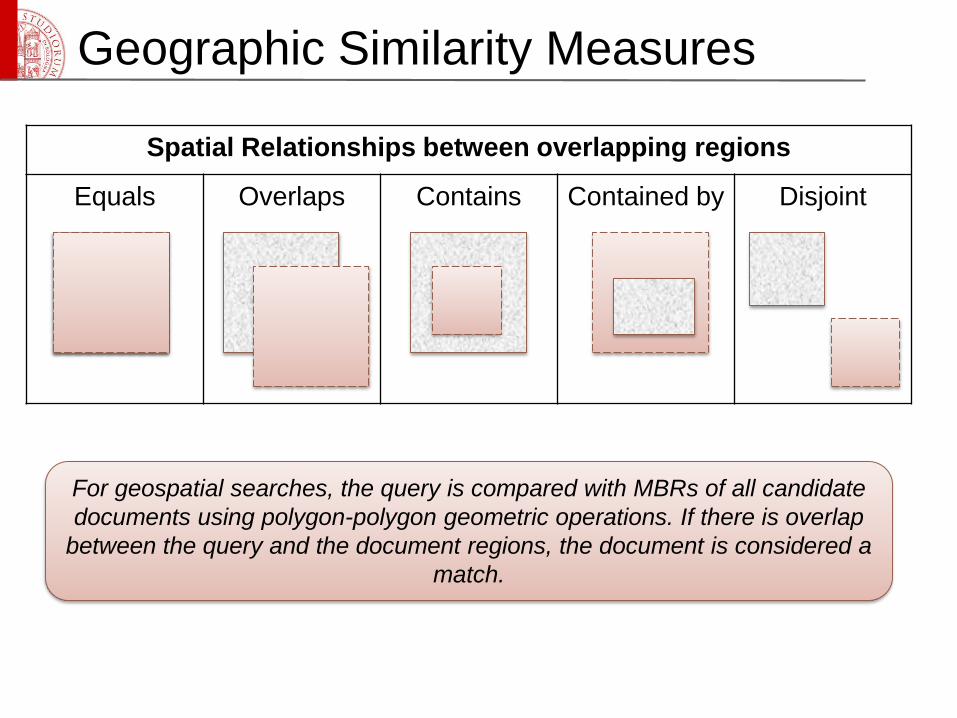
Spatial Relationships between overlapping regions
Equals Overlaps Contains Contained by Disjoint
For geospatial searches, the query is compared with MBRs of all candidate
documents using polygon-polygon geometric operations. If there is overlap
between the query and the document regions, the document is considered a
match.
Geographic Similarity Measures
• GIR ranking methods are based on quantifying the similarity
between the query and a document in the collection.
• This similarity score can be interpreted as an estimate of the
relevance of a candidate document for a user’s information need.
• Retrieved documents are ranked and presented to the user in
descending order of these scores.
Geographic Similarity Measures
• Maron and Kuhns [21] first introduced the idea that, given the
imprecise and incomplete ways in which a user’s information need is
represented by a query and an information document by its indexing,
relevance should be approached probabilistically.
• This is especially true for geographic information retrieval since all
geographic information objects are abstract, compressed
representations of real world phenomena that contain some degree of
error and uncertainty.
• In the logistic regression (LR) model of IR, the estimated probability
of relevance for a particular query and a particular document
𝑃(𝑅|𝑄, 𝐷) is calculated as the log odds of relevance
log 𝑂 𝑅 𝑄,𝐷 and converted from odds to a probability
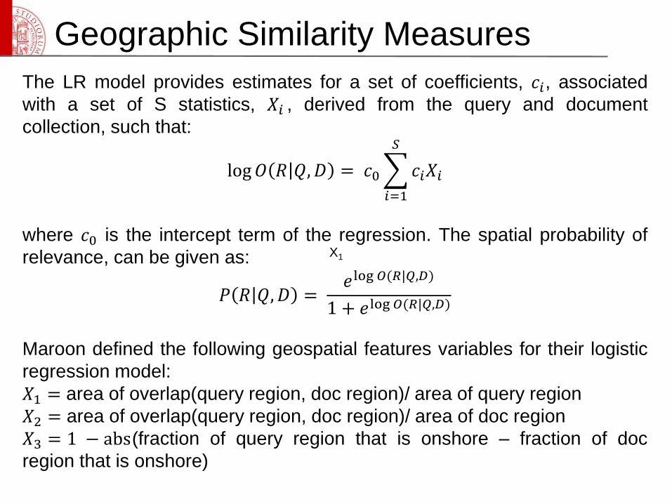
Geographic Similarity Measures
The LR model provides estimates for a set of coefficients, 𝑐𝑖, associated
with a set of S statistics, 𝑋𝑖 , derived from the query and document
collection, such that:
log𝑂 𝑅 𝑄,𝐷 = 𝑐0
𝑖=1
𝑆
𝑐𝑖𝑋𝑖
where 𝑐0 is the intercept term of the regression. The spatial probability of
relevance, can be given as:
𝑃 𝑅 𝑄,𝐷 =𝑒log 𝑂(𝑅|𝑄,𝐷)
1 + 𝑒log 𝑂(𝑅|𝑄,𝐷)
Maroon defined the following geospatial features variables for their logistic
regression model:
𝑋1 = area of overlap(query region, doc region)/ area of query region
𝑋2 = area of overlap(query region, doc region)/ area of doc region
𝑋3 = 1 − abs(fraction of query region that is onshore – fraction of doc
region that is onshore)
X1
Geographic Similarity Measures
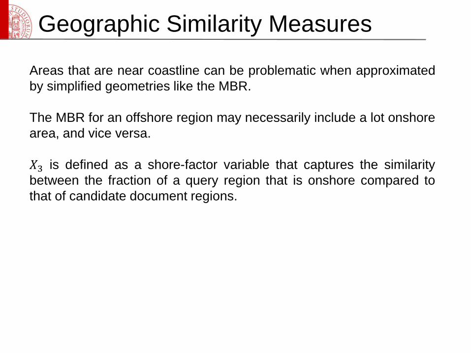
Areas that are near coastline can be problematic when approximated
by simplified geometries like the MBR.
The MBR for an offshore region may necessarily include a lot onshore
area, and vice versa.
𝑋3 is defined as a shore-factor variable that captures the similarity
between the fraction of a query region that is onshore compared to
that of candidate document regions.
Geographic Similarity Measures
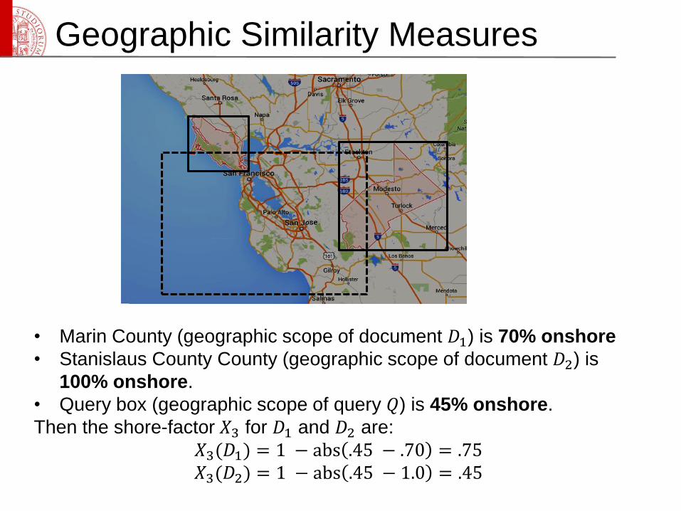
• Marin County (geographic scope of document 𝐷1) is 70% onshore
• Stanislaus County County (geographic scope of document 𝐷2) is
100% onshore.
• Query box (geographic scope of query 𝑄) is 45% onshore.
Then the shore-factor 𝑋3 for 𝐷1 and 𝐷2 are:
𝑋3(𝐷1) = 1 − abs .45 − .70 = .75𝑋3(𝐷2) = 1 − abs .45 − 1.0 = .45
Geographic Similarity Measures
Yong Gao [22] proposed a qualitative approach for supporting
geographic information retrieval based on qualitative representation,
semantic matching and qualitative reasoning
Information in documents and user queries are represented using
propositional logic, which considers the thematic and geographic
semantics synthetically.
Thematic information is represented as thematic propositions on the
base of domain ontology
Spatial information is represented as geo-spatial propositions with the
support of geographic knowledge base.
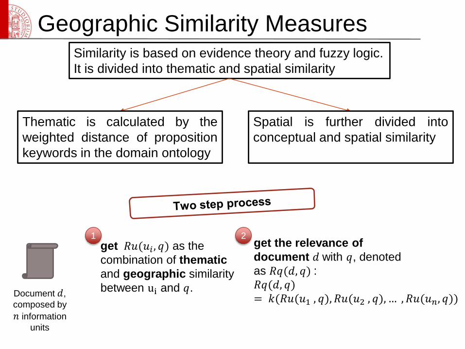
Geographic Similarity MeasuresSimilarity is based on evidence theory and fuzzy logic.
It is divided into thematic and spatial similarity
Thematic is calculated by the
weighted distance of proposition
keywords in the domain ontology
Spatial is further divided into
conceptual and spatial similarity
Document 𝑑,
composed by
𝑛 information
units
get 𝑅𝑢(𝑢𝑖 , 𝑞) as the
combination of thematic
and geographic similarity
between ui and 𝑞.
get the relevance of
document 𝑑 with 𝑞, denoted
as 𝑅𝑞(𝑑, 𝑞) :
𝑅𝑞(𝑑, 𝑞)= 𝑘(𝑅𝑢(𝑢1 , 𝑞), 𝑅𝑢(𝑢2 , 𝑞), … , 𝑅𝑢(𝑢𝑛, 𝑞))
1 2
Geographic Similarity Measures
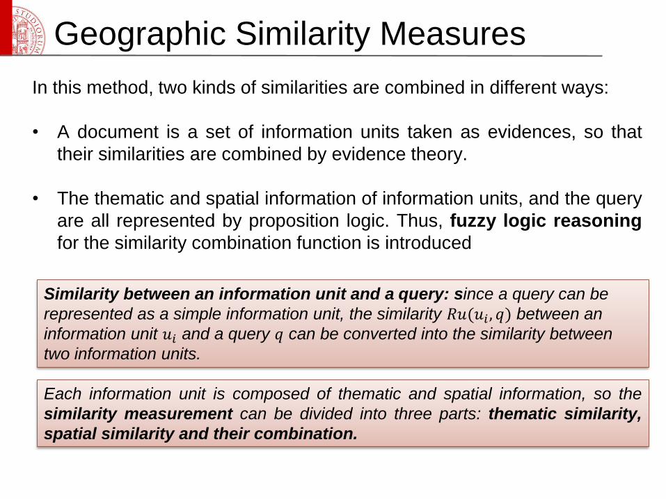
In this method, two kinds of similarities are combined in different ways:
• A document is a set of information units taken as evidences, so that
their similarities are combined by evidence theory.
• The thematic and spatial information of information units, and the query
are all represented by proposition logic. Thus, fuzzy logic reasoning
for the similarity combination function is introduced
Similarity between an information unit and a query: since a query can be
represented as a simple information unit, the similarity 𝑅𝑢(𝑢𝑖 , 𝑞) between an
information unit 𝑢𝑖 and a query 𝑞 can be converted into the similarity between
two information units.
Each information unit is composed of thematic and spatial information, so the
similarity measurement can be divided into three parts: thematic similarity,
spatial similarity and their combination.
Geographic Similarity Measures
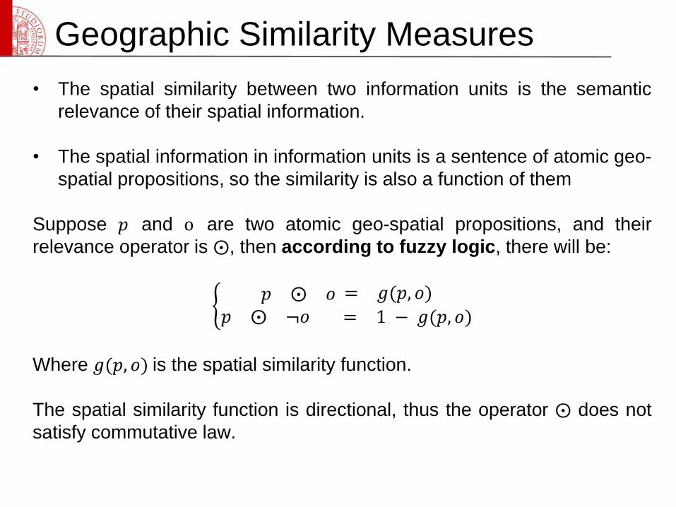
• The spatial similarity between two information units is the semantic
relevance of their spatial information.
• The spatial information in information units is a sentence of atomic geo-
spatial propositions, so the similarity is also a function of them
Suppose 𝑝 and o are two atomic geo-spatial propositions, and their
relevance operator is ⨀, then according to fuzzy logic, there will be:
𝑝 ⨀ 𝑜 = 𝑔(𝑝, 𝑜)
𝑝 ⨀ ¬𝑜 = 1 − 𝑔(𝑝, 𝑜)
Where 𝑔(𝑝, 𝑜) is the spatial similarity function.
The spatial similarity function is directional, thus the operator ⨀ does not
satisfy commutative law.
Geographic Similarity Measures
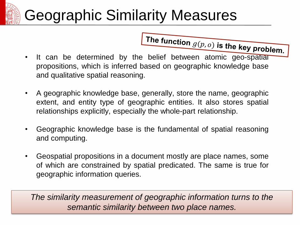
• It can be determined by the belief between atomic geo-spatial
propositions, which is inferred based on geographic knowledge base
and qualitative spatial reasoning.
• A geographic knowledge base, generally, store the name, geographic
extent, and entity type of geographic entities. It also stores spatial
relationships explicitly, especially the whole-part relationship.
• Geographic knowledge base is the fundamental of spatial reasoning
and computing.
• Geospatial propositions in a document mostly are place names, some
of which are constrained by spatial predicated. The same is true for
geographic information queries.
The similarity measurement of geographic information turns to the
semantic similarity between two place names.
Geographic Similarity Measures
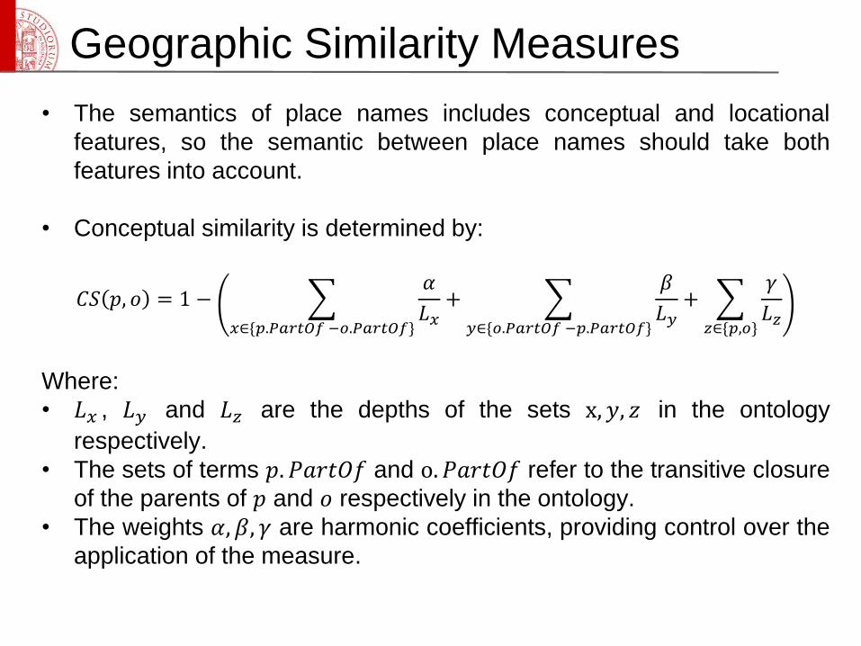
• The semantics of place names includes conceptual and locational
features, so the semantic between place names should take both
features into account.
• Conceptual similarity is determined by:
𝐶𝑆 𝑝, 𝑜 = 1 −
𝑥∈{𝑝.𝑃𝑎𝑟𝑡𝑂𝑓 −𝑜.𝑃𝑎𝑟𝑡𝑂𝑓}
𝛼
𝐿𝑥+
𝑦∈{𝑜.𝑃𝑎𝑟𝑡𝑂𝑓 −𝑝.𝑃𝑎𝑟𝑡𝑂𝑓}
𝛽
𝐿𝑦+
𝑧∈{𝑝,𝑜}
𝛾
𝐿𝑧
Where:
• 𝐿𝑥 , 𝐿𝑦 and 𝐿𝑧 are the depths of the sets x, 𝑦, 𝑧 in the ontology
respectively.
• The sets of terms 𝑝. 𝑃𝑎𝑟𝑡𝑂𝑓 and o. 𝑃𝑎𝑟𝑡𝑂𝑓 refer to the transitive closure
of the parents of 𝑝 and 𝑜 respectively in the ontology.
• The weights 𝛼, 𝛽, 𝛾 are harmonic coefficients, providing control over the
application of the measure.
Geographic Similarity Measures
• The locational similarity is measured based on the rule “topology matters,
metric refines” [23].
Topology similarity
𝐼𝑛𝑠𝑖𝑑𝑒 𝑝, 𝑜 = 𝑁𝑢𝑚𝐷𝑒𝑠𝑐𝑒𝑛𝑑𝑎𝑛𝑡 𝑜 +1
𝑁𝑢𝑚𝐷𝑒𝑠𝑐𝑒𝑛𝑑𝑎𝑛 𝑝 +1, 𝑜 ⊆ 𝑝
0, 𝑜𝑡ℎ𝑒𝑟𝑠
Metric similarity
𝑃𝑟𝑜𝑥𝑖𝑚𝑖𝑡𝑦 𝑝, 𝑜 =1
1+𝐷𝑖𝑠𝑡𝑎𝑛𝑐𝑒(𝑝,𝑜)/𝑑𝑖𝑎𝑔𝑜𝑛𝑎𝑙(𝑝)
Siblings function
𝑆𝑖𝑏𝑙𝑖𝑛𝑔𝑠 𝑝, 𝑜 = 1, 𝑖𝑓 𝑝𝑎𝑟𝑒𝑛𝑡 𝑜𝑓 𝑝 = 𝑝𝑎𝑟𝑒𝑛𝑡 𝑜𝑓 𝑜0, 𝑜𝑡ℎ𝑒𝑟𝑤𝑖𝑠𝑒
• Combine the three values for generating the locational similarity
𝐿𝑆 𝑝, 𝑜 = 𝑏 × 𝐼𝑛𝑠𝑖𝑑𝑒 𝑝, 𝑜 + 𝑃𝑟𝑜𝑥𝑖𝑚𝑖𝑡𝑦 𝑝, 𝑜 + (1 − 𝑏) × 𝑆𝑖𝑏𝑙𝑖𝑛𝑔𝑠(𝑝, 𝑜)
where 𝑏 is a harmonic coefficient ranging from 0 to 1
Geographic Similarity Measures
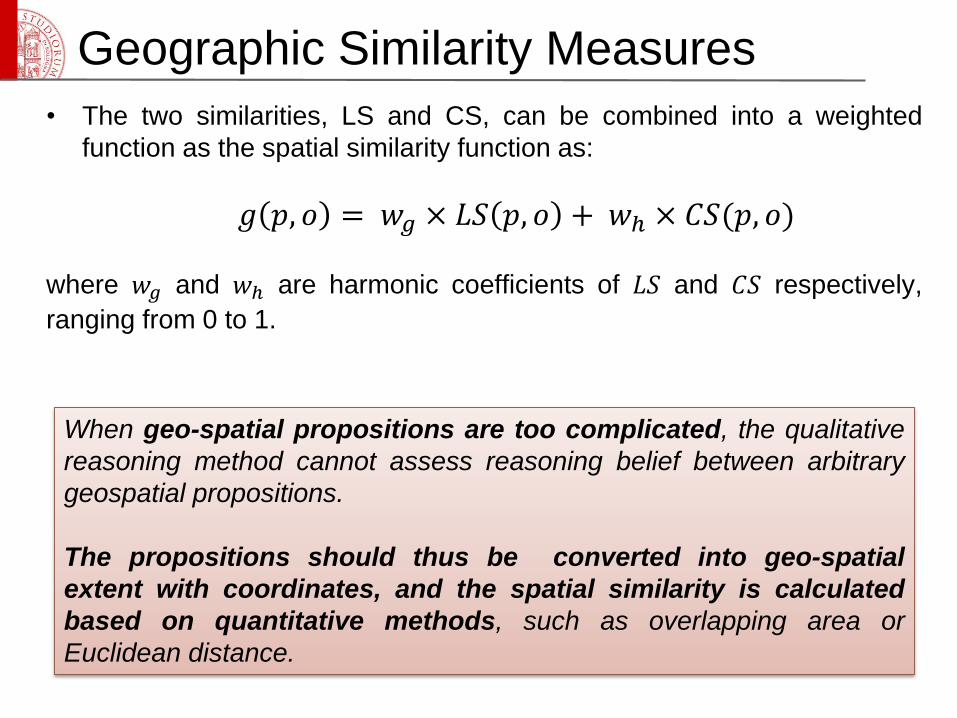
• The two similarities, LS and CS, can be combined into a weighted
function as the spatial similarity function as:
𝑔 𝑝, 𝑜 = 𝑤𝑔 × 𝐿𝑆 𝑝, 𝑜 + 𝑤ℎ × 𝐶𝑆(𝑝, 𝑜)
where 𝑤𝑔 and 𝑤ℎ are harmonic coefficients of 𝐿𝑆 and 𝐶𝑆 respectively,
ranging from 0 to 1.
When geo-spatial propositions are too complicated, the qualitative
reasoning method cannot assess reasoning belief between arbitrary
geospatial propositions.
The propositions should thus be converted into geo-spatial
extent with coordinates, and the spatial similarity is calculated
based on quantitative methods, such as overlapping area or
Euclidean distance.
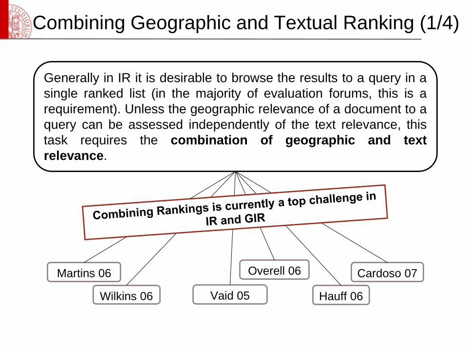
Combining Geographic and Textual Ranking (1/4)
Wilkins 06
Martins 06 Overell 06 Cardoso 07
Vaid 05 Hauff 06
Generally in IR it is desirable to browse the results to a query in a
single ranked list (in the majority of evaluation forums, this is a
requirement). Unless the geographic relevance of a document to a
query can be assessed independently of the text relevance, this
task requires the combination of geographic and text
relevance.
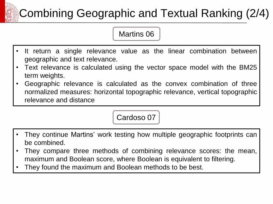
• It return a single relevance value as the linear combination between
geographic and text relevance.
• Text relevance is calculated using the vector space model with the BM25
term weights.
• Geographic relevance is calculated as the convex combination of three
normalized measures: horizontal topographic relevance, vertical topographic
relevance and distance
Martins 06
• They continue Martins’ work testing how multiple geographic footprints can
be combined.
• They compare three methods of combining relevance scores: the mean,
maximum and Boolean score, where Boolean is equivalent to filtering.
• They found the maximum and Boolean methods to be best.
Cardoso 07
Combining Geographic and Textual Ranking (2/4)
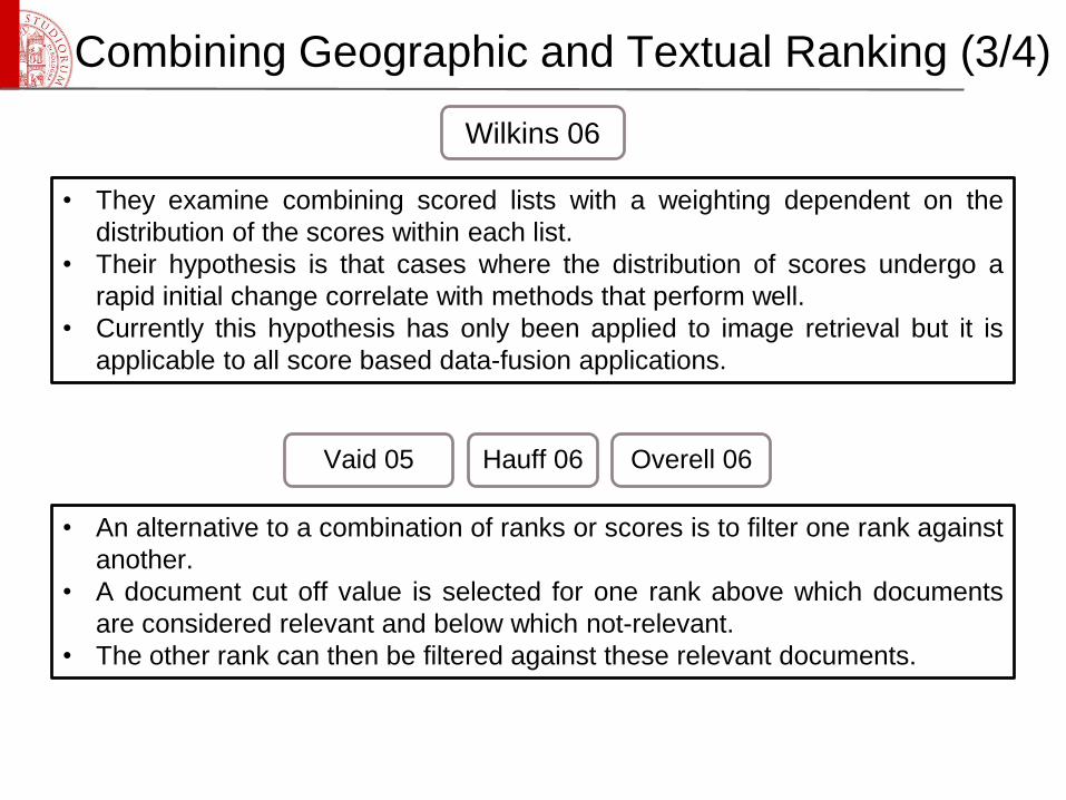
• They examine combining scored lists with a weighting dependent on the
distribution of the scores within each list.
• Their hypothesis is that cases where the distribution of scores undergo a
rapid initial change correlate with methods that perform well.
• Currently this hypothesis has only been applied to image retrieval but it is
applicable to all score based data-fusion applications.
Wilkins 06
• An alternative to a combination of ranks or scores is to filter one rank against
another.
• A document cut off value is selected for one rank above which documents
are considered relevant and below which not-relevant.
• The other rank can then be filtered against these relevant documents.
Vaid 05 Hauff 06 Overell 06
Combining Geographic and Textual Ranking (3/4)
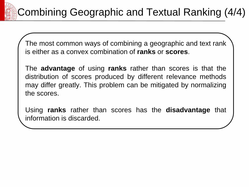
The most common ways of combining a geographic and text rank
is either as a convex combination of ranks or scores.
The advantage of using ranks rather than scores is that the
distribution of scores produced by different relevance methods
may differ greatly. This problem can be mitigated by normalizing
the scores.
Using ranks rather than scores has the disadvantage that
information is discarded.
Combining Geographic and Textual Ranking (4/4)
GIR Evaluation
• The experimental evaluation of IR systems is a subject that
has received a lot of attention over the past 40 years.
• IR systems are inherently designed to fulfil a user’s
information need; testing how well this subjective judgement
has been fulfilled is not an easy task.
• Cleverdon [24] proposed the Cranfield methodology. It
involves a standard triple of a corpus, queries and relevance
judgements (C, Q, R) to be provided allowing different IR
systems to be compared. The corpus C is a collection of
documents, the queries Q a set of requests for information,
and the relevance judgements R a set of documents from the
collection that fulfil each information request.
Evaluation Forums (1/2)
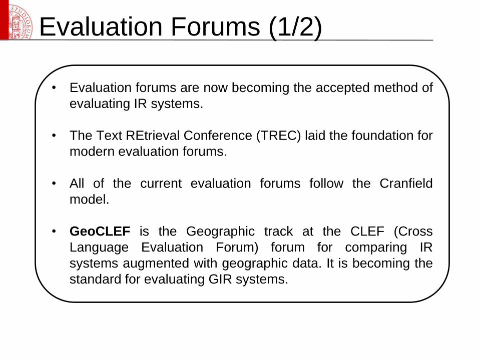
• Evaluation forums are now becoming the accepted method of
evaluating IR systems.
• The Text REtrieval Conference (TREC) laid the foundation for
modern evaluation forums.
• All of the current evaluation forums follow the Cranfield
model.
• GeoCLEF is the Geographic track at the CLEF (Cross
Language Evaluation Forum) forum for comparing IR
systems augmented with geographic data. It is becoming the
standard for evaluating GIR systems.
Evaluation Forums (2/2)
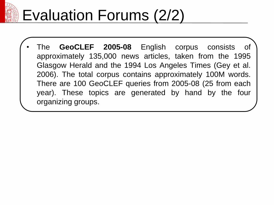
• The GeoCLEF 2005-08 English corpus consists of
approximately 135,000 news articles, taken from the 1995
Glasgow Herald and the 1994 Los Angeles Times (Gey et al.
2006). The total corpus contains approximately 100M words.
There are 100 GeoCLEF queries from 2005-08 (25 from each
year). These topics are generated by hand by the four
organizing groups.
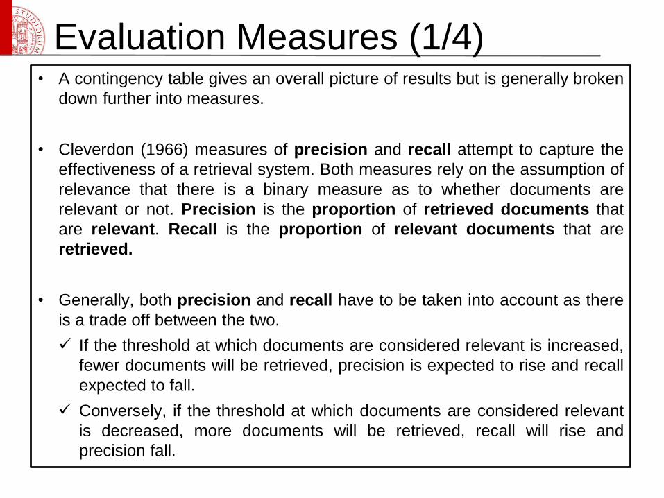
Evaluation Measures (1/4)• A contingency table gives an overall picture of results but is generally broken
down further into measures.
• Cleverdon (1966) measures of precision and recall attempt to capture the
effectiveness of a retrieval system. Both measures rely on the assumption of
relevance that there is a binary measure as to whether documents are
relevant or not. Precision is the proportion of retrieved documents that
are relevant. Recall is the proportion of relevant documents that are
retrieved.
• Generally, both precision and recall have to be taken into account as there
is a trade off between the two.
If the threshold at which documents are considered relevant is increased,
fewer documents will be retrieved, precision is expected to rise and recall
expected to fall.
Conversely, if the threshold at which documents are considered relevant
is decreased, more documents will be retrieved, recall will rise and
precision fall.
Evaluation Measures (2/4)
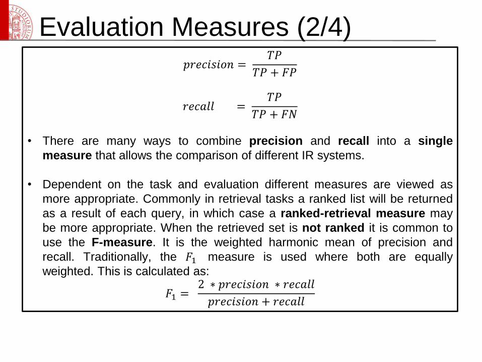
𝑝𝑟𝑒𝑐𝑖𝑠𝑖𝑜𝑛 =𝑇𝑃
𝑇𝑃 + 𝐹𝑃
𝑟𝑒𝑐𝑎𝑙𝑙 =𝑇𝑃
𝑇𝑃 + 𝐹𝑁
• There are many ways to combine precision and recall into a single
measure that allows the comparison of different IR systems.
• Dependent on the task and evaluation different measures are viewed as
more appropriate. Commonly in retrieval tasks a ranked list will be returned
as a result of each query, in which case a ranked-retrieval measure may
be more appropriate. When the retrieved set is not ranked it is common to
use the F-measure. It is the weighted harmonic mean of precision and
recall. Traditionally, the 𝐹1 measure is used where both are equally
weighted. This is calculated as:
𝐹1 =2 ∗ 𝑝𝑟𝑒𝑐𝑖𝑠𝑖𝑜𝑛 ∗ 𝑟𝑒𝑐𝑎𝑙𝑙
𝑝𝑟𝑒𝑐𝑖𝑠𝑖𝑜𝑛 + 𝑟𝑒𝑐𝑎𝑙𝑙
Evaluation Measures (3/4)
• Intuitively it makes sense that some documents will be more relevant to an
information need than others.
• Precision at n (P@N) is a measure that models how a system is used. It can
be assumed that in a real system a user will not trawl through page after
page of results looking for a relevant document (iProspect 2006). It is
assumed a user will only look at the first n documents (where n is 5, 10, 20
etc...); the precision is calculated after the first n documents.
• P@N is limited as a comparator, as it varies significantly with the number of
relevant documents and the selected value of n.
• Average precision (AP) is a measure that attempts not to penalize systems
for setting the relevance required-for-acceptance threshold too high or too
low. It relies on systems being able to quantify relevance and rank
documents by their relevance. AP is the average of precisions computed at
each relevant document rank.
Evaluation Measures (4/4)
• F-measure, P@N and AP all provide a single per-query effectiveness
value of an IR system. However, it is common in evaluation forums to
represent the effectiveness of a system executed across all queries with a
single number (making comparing systems as easy as possible).
• The arithmetic mean is the most common method of combining per-query
results. The arithmetic mean of the average precision (short mean average
precision or MAP) is the major evaluation measure for IR systems that
produce a ranked set of results.
Information Retrieval Frameworks (1/2)
Apache Lucene is a high-performance, full-featured text search
indexing and searching library written entirely in Java. Apache
Lucene is highly reputed for its performance and scalability, and
is vastly used worldwide. Lucene is developed by the Apache
Foundation. See http://lucene.apache.org/ for more information.
Apache Nutch is an open-source search engine implemented in
Java, which uses Apache Lucene. It is a very efficient search
engine, but lacking some state-of-the-art ranking algorithms, such
as Okapi’s BM25. One of its key features is the ability to extend
its functionalities through the use of self contained software plug-
ins. Nutch is also developed by the Apache Foundation. For more
information, see http://lucene.apache.org/nutch/
Information Retrieval Frameworks (2/2)
Lemur Toolkit is an open-source toolkit designed to facilitate
research in language modeling and information retrieval. Lemur
supports a wide range of industrial and research language
applications, such as ad-hoc retrieval, site-search, and text
mining. Lemur is implemented in C/C++. See
http://www.lemurproject.org/ for more information.
Terrier is a modular platform for the rapid development of large-
scale IR applications, providing indexing and retrieval
functionalities, developed by the Information Retrieval Research
Group of the Department of Computing Sciences of the University
of Glasgow. Terrier has various cutting edge features, including
parameter-free probabilistic retrieval approaches (such as
Divergence from Randomness models), automatic query
expansion/re-formulation methodologies, and efficient data
compression techniques. Terrier is written in Java. See
http://ir.dcs.gla.ac.uk/terrier/ for more information.
Terrier Framework
• Terrier is open source, and is a comprehensive, flexible and
transparent platform for research and experimentation in text
retrieval. Research can easily be carried out on standard
TREC and CLEF test collections.
• Terrier can index large corpora of documents, and provides
multiple indexing strategies, such as multi-pass, single-pass
and large-scale MapReduce indexing. Real-time indexing of
document streams are also supported via updatable index
structures.
• State-of-the-art retrieval approaches are provided, such as
Divergence From Randomness, BM25F, as well as term
dependence proximity models. Support for supervised ranking
models via Learning to Rank is also built-in.
Terrier Framework
• Terrier is ideal for performing information retrieval
experiments. It can index and perform batch retrieval
experiments for all known TREC test collections. Tools to
evaluate experiments results are also included.
• Terrier uses UTF internally, and can support corpora written in
languages other than English.
• Terrier follows a plugin architecture, and it is easy to extend
to develop new retrieval techniques, add new ranking features
or experiment with low-level functionality such as index
compression.
Some current challenges
• Improve GIR components and methods
Geo-tagging, geospatial-textual indexing and geo-
relevance ranking.
Improved understanding of spatial natural language
terminology.
Evaluation of GIR systems.
• Integration of geographical with temporal aspects
• Creation of reliable place ontologies with world-wide coverage
References
[1] Christopher D. Manning, Prabhakar Raghavan and Hinrich
Schütze, Introduction to Information Retrieval, Cambridge
University Press. 2008
[2] Mark, David M. "Geographic information science: Defining the
field." Foundations of geographic information science 1 (2003): 3-
18.
[3] Yinghua Zhou, Xing Xie, Chuang Wang, Yuchang Gong and
Wei-Ying Ma, Hybrid Index Structures for Location-based Web
Search, CIKM’05, Bremen, Germany, 2005
[4] R. Hariharan, B. Hore, C. Li, and S. Mehrotra. Processing
spatial lkeyword (sk) queries in geographic information retrieval (gir
systems. In SSDBM, page 16, 2007
References[5] A. G. Woodruff, C. Plaunt, Gipsy: Georeferenced information
processing system, Journal of the American Society for Information
Science 45 (9) (1994) 645-655.
[6] J. Ding, L. Gravano, N. Shivakumar, Computing geographical
scopes of web resources, In Proceedings of the 26th International
Conference on Very Large Data Bases (VLDB '00), San Francisco,
CA, USA, (2000) 545-556.
[7] B. Martins, M. J. Silva, A graph-ranking algorithm for geo-
referencing documents, in: 2013 IEEE 13th International
Conference on Data Mining, IEEE Computer Society, 2005, pp.
741-744.
[8] E. Amitay, N. Har'El, R. Sivan, A. Soer, Web-a-where:
geotagging web content, in: Proceedings of the 27th annual
international ACM SIGIR conference on Research and
development in information retrieval, ACM, 2004, pp. 273-280.
References[9] J. L. Leidner, Toponym resolution in text: Annotation,
evaluation and applications of spatial grounding of place names,
PhD thesis, Institute of Communicating and Collaborative Systems,
School of Informatics, University of Edinburgh.
[10] C. E. C. Campelo, C. de Souza Baptista, A model for
geographic knowledge extraction on web documents, in: Advances
in Conceptual Modeling-Challenging Perspectives, Springer, 2009,
pp. 317-326.
[11] N. Cardoso, M. J. Silva, Query expansion through
geographical feature types, in: Proceedings of the 4th ACM
workshop on Geographical information retrieval, ACM, 2007, pp.
55-60.
[12] D. Buscaldi, P. Rosso, E. S. Arnal, Using the wordnet
ontology in the geoclef geographical information retrieval task, in:
GeoCLEF2005, Springer-Verlag, 2006, pp. 939-946.
References[13] N. Stokes, Y. Li, A. Moat, J. Rong, An empirical study of the
effects of nlp components on geographic ir performance,
International Journal of Geographical Information Science 22 (3)
(2008) 247-264.
[14] P. Clough, Extracting metadata for spatially-aware information
retrieval on the internet, in: Proceedings of the 2005 workshop on
Geographic information retrieval, ACM, 2005, pp. 25-30.
[15] M. F. Goodchild, Geographical data modeling, Computers &
Geosciences 18 (4) (1992) 401-408.
[16] Larson, R.R. and Frontiera, P., 2004, Spatial ranking methods
for geographic information retrieval (GIR) in digital libraries. In
Research and Advanced Technology for Digital Libraries: 8th
European Conference, ECDL 2004, R. Heery and L. Lyon (Eds).
September 2004, Bath, UK, Lecture Notes in Computer Science
3232 (Berlin: Springer), pp. 45-57.
References[17] Geoffrey Andogah. Geographically Constrained Information
Retrieval. PhD thesis, University of Groningen, 2010
[18] L. L. Hill. Access to Geographic Concepts in Online
Bibliographic Files: Effectiveness of Current Practices and the
Potential of a Graphic Interface. PhD thesis, University of
Pittsburgh, 1990.
[19] Walker, D., I. Newman, D. Medyckyj-Scott and C. Ruggles
(1992). “A system for identifying datasets for GIS users.”
International Journal of Geographical Information Systems 6(6):
511-527
[20] M.K. Beard and V. Sharma. Multidimensional Ranking in
Digital Spatial Libraries. In Special Issue of Metadata. Journal of
Digital Libraries, Vol.1, No. 1, 1997.
References[21] Maron, Melvin Earl; KUHNS, John L. On relevance,
probabilistic indexing and information retrieval. Journal of the ACM
(JACM), 1960, vol. 7, no 3, p. 216-244.
[22] Gao, Yong, et al. A Qualitative Representation and Similarity
Measurement Method in Geographic Information Retrieval. arXiv
preprint arXiv:1311.4644, 2013.
[23] Mark, D. M. (1999). Spatial representation: a cognitive
view. Geographical information systems: principles and
applications,, 1, 81-89.
[24] Cleverdon, C. W. (1970). The effect of variations in relevance
assessments in comparative experimental tests of index
languages. Cranfield, UK: Cranfield Institute of Technology.
(Cranfield Library Report No. 3)