Embed Size (px)
Citation preview
Peregrinations: Journal of Peregrinations: Journal of
Medieval Art and Architecture Medieval Art and Architecture
Volume 6 Issue 3 21-42
4-2018
Geographies of Salvation: How to Read Medieval Mappae Mundi Geographies of Salvation: How to Read Medieval Mappae Mundi
Felicitas Schmieder FernUniversität, Hagen
Follow this and additional works at: https://digital.kenyon.edu/perejournal
Part of the Ancient, Medieval, Renaissance and Baroque Art and Architecture Commons
Recommended Citation Recommended Citation Schmieder, Felicitas. "Geographies of Salvation: How to Read Medieval Mappae Mundi." Peregrinations: Journal of Medieval Art and Architecture 6, 3 (2018): 21-42. https://digital.kenyon.edu/perejournal/vol6/iss3/2
This Feature Article is brought to you for free and open access by Digital Kenyon: Research, Scholarship, and Creative Exchange. It has been accepted for inclusion in Peregrinations: Journal of Medieval Art and Architecture by an authorized editor of Digital Kenyon: Research, Scholarship, and Creative Exchange. For more information, please contact [email protected].

21
____________________PEREGRINATIONS____________________
JOURNAL OF MEDIEVAL ART AND ARCHITECTURE
VOLUME VI, NUMBER 3 (SPRING 2018)
Geographies of Salvation: How to Read Medieval Mappae Mundi
FELICITAS SCHMIEDER
FernUniversität in Hagen
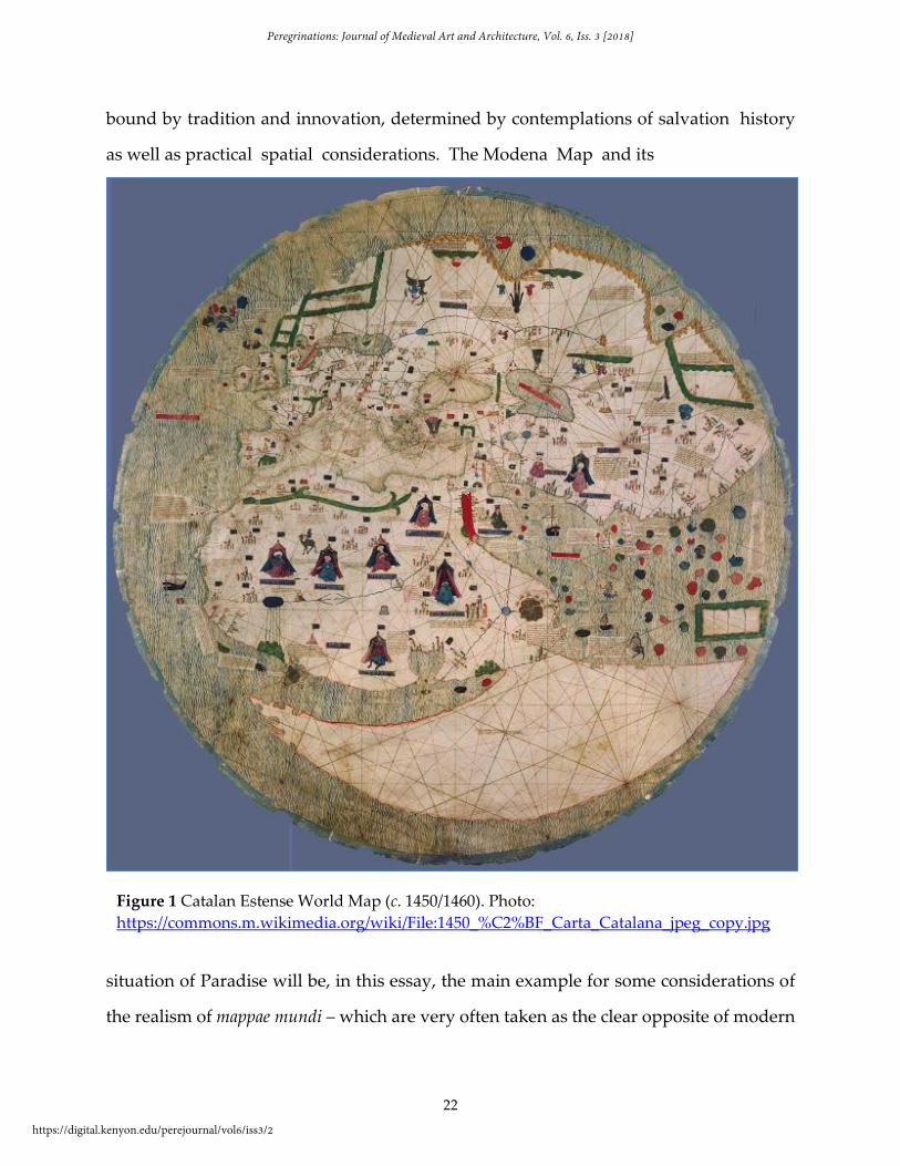
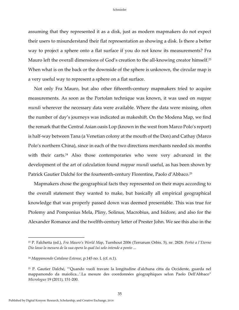
This region is the Terrestrial Paradise, an especially lovely place. Paradise
is completely surrounded by fire whose flames reach the sky. … In Paradise
lies a source divided in four rivers: One is Euphrates, the second Tigris, the
third Gyon, the fourth Phison.… Isidore speaks about this place saying that
Paradise is situated in the middle of the Equator.1
This is an abbreviated caption from the Catalan Estense World Map (c. 1450/1460) (Fig.
1) describing a circular garden surrounded by flames and placed in eastern Africa, from
which the mentioned source springs and in which two red figures pray under a tree.2
Placing Paradise in eastern Africa on medieval maps is very unusual – as will be seen in
this article – and is at the same time typical for late medieval mappae mundi that were both
1Il Mappamondo Catalano Estense (Die Katalanische Estense Weltkarte), ed. E. Milano/ A. Battini, Zurich 1995,
p.185 no. H: Aquesta ragio es p(ar)adis teranall / loquall es molt delitable loch en / loqual p(ar)adis as murat tot
defoch / los quals puien trofins alcell / en lo quall es larbre deuida lofruyt / delqual arbre sediu que quin manjaua /
seria jn mortal deldit p(ar)adis hix vna / ffont laqual sep(er)tex en quat(er) parts lahu / eufrates latra trigis [sic!] laltra
tragion laltra / frixon deualam(en)t qual aygua fa tanfort / brogit que los qujnexe(n) nexen sorts de aquest / loc parla
ysodor(us) dient / que p(ar)adis teranall es en / mig delaqujnocsiall lo quall es molt / delitable loch sens
comp(ar)acio...nloquall / es p(ar)adis teranall.
2 E. Edson, The world map, 1300–1492: The persistence of tradition and transformation, Baltimore 2007, 197.
Among other things it is one of the first maps to note down Cabo Roxo, reached by the Portuguese in 1446,
cf. T. Campbell, “Portolan Charts from the Late Thirteenth Century to 1500” in History of Cartography (HOC)
I, eds. J. B. Harley/ D. Woodward, Chicago/ London 1987, 371-463, here 412. In the online “report,” there is
a reasonably well-done image facsimile of the map which can be checked: Arthur Dürst, “Die Katalanische
Estense-Weltkarte, um 1450. Bericht zur Faksimile-Ausgabe” in Cartographica Helvetica. Fachzeitschrift für
Kartengeschichte 14 (1996) 42-44 = http://doi.org/10.5169/seals-8249.
Schmieder
Published by Digital Kenyon: Research, Scholarship, and Creative Exchange, 2018
22
bound by tradition and innovation, determined by contemplations of salvation history
as well as practical spatial considerations. The Modena Map and its
situation of Paradise will be, in this essay, the main example for some considerations of
the realism of mappae mundi – which are very often taken as the clear opposite of modern
Figure 1 Catalan Estense World Map (c. 1450/1460). Photo:
https://commons.m.wikimedia.org/wiki/File:1450_%C2%BF_Carta_Catalana_jpeg_copy.jpg
Peregrinations: Journal of Medieval Art and Architecture, Vol. 6, Iss. 3 [2018]
https://digital.kenyon.edu/perejournal/vol6/iss3/2
23
maps based on the measurable “reality” of geography. Medieval mappae mundi do not
represent geographical space in a way we are used to. From a modern point of view, they
show earth in an incorrect way, with distorted dimensions: they are, allegedly, not yet
able to represent space in a rational and useful way. Looking at them from a medieval
point of view they may not at all have been intended to fulfil expectations like these
modern ones. Scholars who judge mappae mundi by medieval standards usually
emphasize the salvific over the practical aspect. But were mappae mundi truly not
“realistic”?
As a first step, I present the Modena Map as an example of a mappa mundi, define
mappae mundi as representations of “Geographies of Salvation,” and present the
principles of the Geography of Salvation, along with the demands they had to meet. My
hypothesis is that mappae mundi as Geographies of Salvation have to be read on several
levels at the same time – and that these levels can have weigh differently on different
maps depending on what the mapmaker wanted to emphasize. Among these levels of
understanding we find the literal sense, which demands, in principle, that the
representation of physical features had to be as close to nature as possible, given the
information the mapmaker had at hand. In addition to the literal content, symbolic levels
– moral, allegorical, eschatological – were considered and read accordingly.
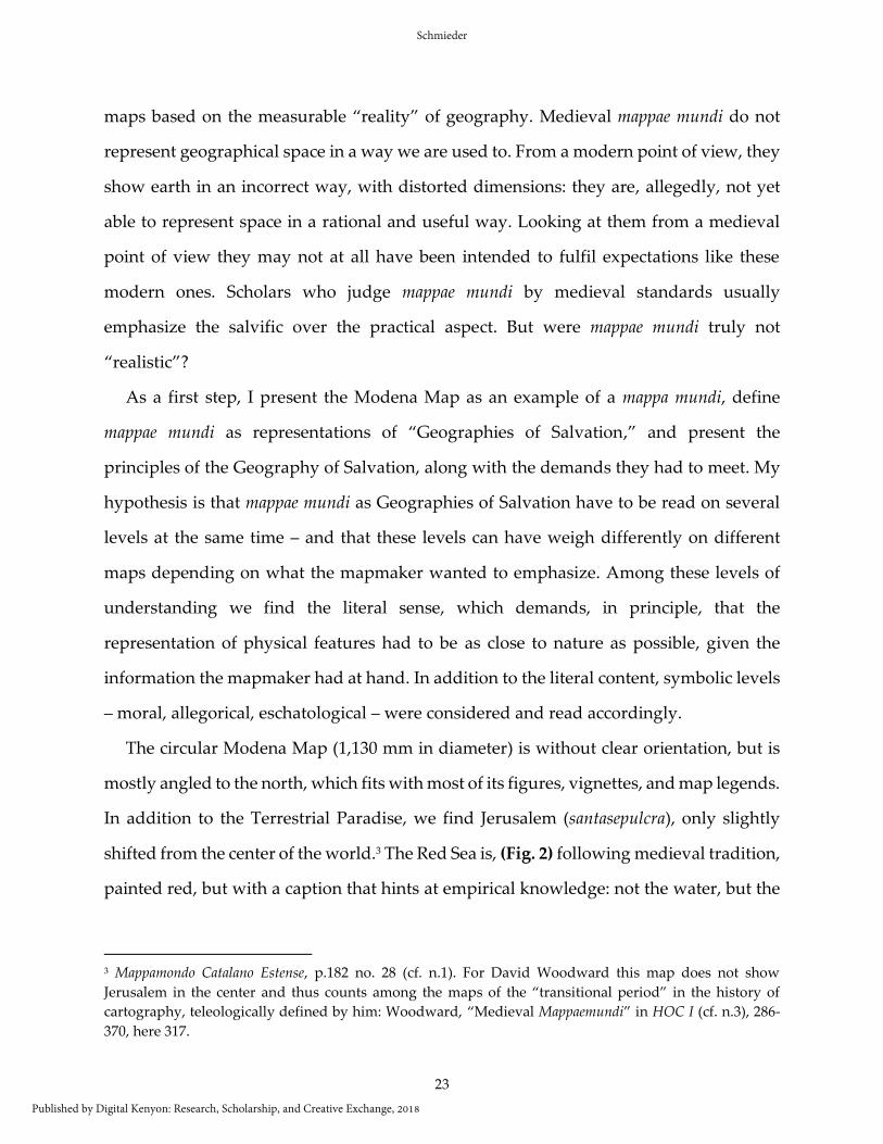
The circular Modena Map (1,130 mm in diameter) is without clear orientation, but is
mostly angled to the north, which fits with most of its figures, vignettes, and map legends.
In addition to the Terrestrial Paradise, we find Jerusalem (santasepulcra), only slightly
shifted from the center of the world.3 The Red Sea is, (Fig. 2) following medieval tradition,
painted red, but with a caption that hints at empirical knowledge: not the water, but the
3 Mappamondo Catalano Estense, p.182 no. 28 (cf. n.1). For David Woodward this map does not show
Jerusalem in the center and thus counts among the maps of the “transitional period” in the history of
cartography, teleologically defined by him: Woodward, “Medieval Mappaemundi” in HOC I (cf. n.3), 286-
370, here 317.
Schmieder
Published by Digital Kenyon: Research, Scholarship, and Creative Exchange, 2018

24
sea bottom is red.4 In the distant northeast, Gog and Magog are enclosed, the peoples of
the endtime who will come out (vindra) to help Antichrist.5 The Mediterranean and Black
Sea, as well as the European and large parts of the African Atlantic coast, are drawn
according to Portolan measuring techniques.
Elsewhere, the mapmaker was aware of the empirical travel knowledge of his time, be
it in Asia or in Western Africa. Not only are the Portuguese discoveries up to 1445
represented, but we find the Caspian Sea only once on the map and as an inland sea with
4 Mappamondo Catalano Estense, p.183 no. D (cf. n.1). This was noticed already by Fulcher of Chartres in the
context of the first crusade: Fulcherus Carnotensis, Historia Hierosolymitana (1095–1127) II, 57, 1, ed.
Heinrich Hagenmeyer, Heidelberg 1913, 596-597.
5 Mappamondo Catalano Estense, p.145 no. I (cf. n.1).
Figure 2 Detail of the Catalan Estense World Map with the Red Sea at the bottom center (c.
1450/1460), Modena Biblioteca Estense, library, Italy. Photo:
https://commons.m.wikimedia.org/wiki/File:1450_%C2%BF_Carta_Catalana_jpeg_copy.jpg
Peregrinations: Journal of Medieval Art and Architecture, Vol. 6, Iss. 3 [2018]
https://digital.kenyon.edu/perejournal/vol6/iss3/2
25
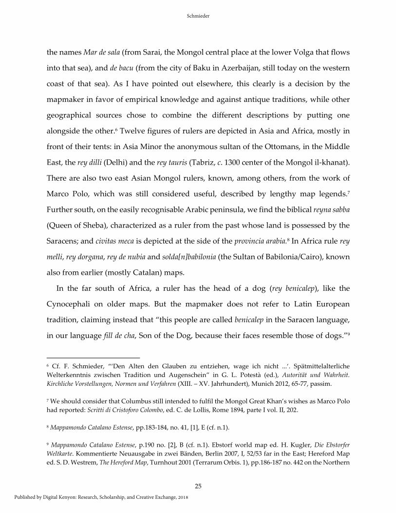
the names Mar de sala (from Sarai, the Mongol central place at the lower Volga that flows
into that sea), and de bacu (from the city of Baku in Azerbaijan, still today on the western
coast of that sea). As I have pointed out elsewhere, this clearly is a decision by the
mapmaker in favor of empirical knowledge and against antique traditions, while other
geographical sources chose to combine the different descriptions by putting one
alongside the other.6 Twelve figures of rulers are depicted in Asia and Africa, mostly in
front of their tents: in Asia Minor the anonymous sultan of the Ottomans, in the Middle
East, the rey dilli (Delhi) and the rey tauris (Tabriz, c. 1300 center of the Mongol il-khanat).
There are also two east Asian Mongol rulers, known, among others, from the work of
Marco Polo, which was still considered useful, described by lengthy map legends.7
Further south, on the easily recognisable Arabic peninsula, we find the biblical reyna sabba
(Queen of Sheba), characterized as a ruler from the past whose land is possessed by the
Saracens; and civitas meca is depicted at the side of the provincia arabia.8 In Africa rule rey
melli, rey dorgana, rey de nubia and solda[n]babilonia (the Sultan of Babilonia/Cairo), known
also from earlier (mostly Catalan) maps.
In the far south of Africa, a ruler has the head of a dog (rey benicalep), like the
Cynocephali on older maps. But the mapmaker does not refer to Latin European
tradition, claiming instead that “this people are called benicalep in the Saracen language,
in our language fill de cha, Son of the Dog, because their faces resemble those of dogs.”9
6 Cf. F. Schmieder, “‘Den Alten den Glauben zu entziehen, wage ich nicht ...‘. Spätmittelalterliche
Welterkenntnis zwischen Tradition und Augenschein” in G. L. Potestà (ed.), Autorität und Wahrheit.
Kirchliche Vorstellungen, Normen und Verfahren (XIII. – XV. Jahrhundert), Munich 2012, 65-77, passim.
7 We should consider that Columbus still intended to fulfil the Mongol Great Khan’s wishes as Marco Polo
had reported: Scritti di Cristoforo Colombo, ed. C. de Lollis, Rome 1894, parte I vol. II, 202.
8 Mappamondo Catalano Estense, pp.183-184, no. 41, [1], E (cf. n.1).
9 Mappamondo Catalano Estense, p.190 no. [2], B (cf. n.1). Ebstorf world map ed. H. Kugler, Die Ebstorfer
Weltkarte. Kommentierte Neuausgabe in zwei Bänden, Berlin 2007, I, 52/53 far in the East; Hereford Map
ed. S. D. Westrem, The Hereford Map, Turnhout 2001 (Terrarum Orbis. 1), pp.186-187 no. 442 on the Northern
Schmieder
Published by Digital Kenyon: Research, Scholarship, and Creative Exchange, 2018

26
This entry clearly comes from a source – be it oral or written – that is built on information
by Arabic speakers. When such information was taken from people considered
eyewitnesses (and this is true also if they were describing things we may judge as not
real), it was considered empirical (however much that may deviate from our
understanding) but could, at the same time, be used for spiritual purposes. On the
Modena Map, Christian and Muslim forces are positioned opposite each other. As the
mapmaker points out, the king of Organa is continuously fighting the sarains, and the
king of Nubia is constantly fighting the Nubian Christians, who are under the rule of
presta iohan (Prester John), the great Latin crusade hope from the twelfth century.10 He is
seated a bit west of the Terrestrial Paradise.11
Slightly north of Prester John, two rivers flow together and then go onward, as the
Nile, to Egypt and the Mediterranean. One of the rivers springs from Paradise, the other
from the west, where it shares a headwater with another river that then flows to the west
and into the Atlantic. The latter has five tributaries that come from the south and out of
the gibelcamar. This name quotes Ptolemaic and Arabic traditions, in which it usually is
the Nile that springs from the Djibal-qomr, the Mountain of the Moon.12 On Ptolemaic,
Arabic, and Latin European world maps that note this version of the Nile’s sources, these
rim of the map. On both maps we find numerous monstra also on the Southern rim: but these kinds of
figures are always marginal. For the monsters on the maps cf. A. S. Mittman, Maps and Monsters in Medieval
England, New York-London 2006. 10 These opposed groups are even clearer on another map from a similar time and probably also of Catalan
origin, on which Africa is divided between Christians and Muslims – among them the dog-headed
Abinichibel – and thus between the two main religious-political forces that would decide the fate of the
world. We find it on the so-called Borgia- or Velletri-map, a circular map carved into a metal plate, between
1402 and probably 1453, cf. Felicitas Schmieder, “Anspruch auf christliche Weltherrschaft. Die Velletri/
Borgia-Karte (15. Jahrhundert) in ihrem ideengeschichtlichen und politischen Kontext” in Ingrid
Baumgärtner/ Martina Stercken (eds.), Herrschaft verorten. Politische Kartographie im Mittelalter und in der
frühen Neuzeit, Zürich 2012, 253 -271.
11 Mappamondo Catalano Estense, p.179 no. [6], R (cf. n.1).
12 R. Hennig, Terrae Incognitae. Eine Zusammenstellung und kritische Bewertung der wichtigsten vorcolumbischen
Entdeckungsreisen anhand der darüber vorliegenden Originalberichte, 4 Bde., Leiden 1936, I, ch. 64, 357-362.
Peregrinations: Journal of Medieval Art and Architecture, Vol. 6, Iss. 3 [2018]
https://digital.kenyon.edu/perejournal/vol6/iss3/2
27
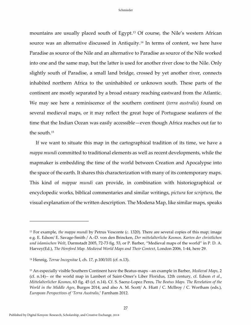
mountains are usually placed south of Egypt.13 Of course, the Nile’s western African
source was an alternative discussed in Antiquity.14 In terms of content, we here have
Paradise as source of the Nile and an alternative to Paradise as source of the Nile worked
into one and the same map, but the latter is used for another river close to the Nile. Only
slightly south of Paradise, a small land bridge, crossed by yet another river, connects
inhabited northern Africa to the uninhabited or unknown south. These parts of the
continent are mostly separated by a broad estuary reaching eastward from the Atlantic.
We may see here a reminiscence of the southern continent (terra australis) found on
several medieval maps, or it may reflect the great hope of Portuguese seafarers of the
time that the Indian Ocean was easily accessible—even though Africa reaches out far to
the south.15
If we want to situate this map in the cartographical tradition of its time, we have a
mappa mundi committed to traditional elements as well as recent developments, while the
mapmaker is embedding the time of the world between Creation and Apocalypse into
the space of the earth. It shares this characterization with many of its contemporary maps.
This kind of mappae mundi can provide, in combination with historiographical or
encyclopedic works, biblical commentaries and similar writings, pictura for scriptura, the
visual explanation of the written description. The Modena Map, like similar maps, speaks
13 For example, the mappa mundi by Petrus Vesconte (c. 1320). There are several copies of this map; image
e.g. E. Edson/ E. Savage-Smith / A.-D. von den Brincken, Der mittelalterliche Kosmos. Karten der christlichen
und islamischen Welt, Darmstadt 2005, 72-73 fig. 53, or P. Barber, “Medieval maps of the world” in P. D. A.
Harvey(Ed.), The Hereford Map. Medieval World Maps and Their Context, London 2006, 1-44, here 29.
14 Hennig, Terrae Incognitae I, ch. 17, p.100/101 (cf. n.13).
15 An especially visible Southern Continent have the Beatus-maps --an example in Barber, Medieval Maps, 2
(cf. n.14)-- or the world map in Lambert of Saint-Omer’s Liber Floridus, 12th century, cf. Edson et al.,
Mittelalterlicher Kosmos, 63 fig. 45 (cf. n.14). Cf. S. Saenz-Lopez Peres, The Beatus Maps. The Revelation of the
World in the Middle Ages, Burgos 2014, and also A. M. Scott/ A. Hiatt / C. McIlroy / C. Wortham (eds.),
European Perspectives of ‘Terra Australis,’ Farnham 2012.
Schmieder
Published by Digital Kenyon: Research, Scholarship, and Creative Exchange, 2018
28
for itself, because sufficient scriptura has been included in its pictura. So how do we read
them?
Since the map’s affinity to God and Creation is obvious, it should also be obvious that
the mappa mundi has been “written” and must be read like the Bible and other religious
texts. That is, they can be read according to the literal and spiritual sensus scripturae, or in
a way that recognizes their polysemous nature, that processes them on four levels: the
literal-historical, the moral-tropological, the allegorical-typological, and the anagogical-
eschatological.16 For example, the Terrestrial Paradise is regularly depicted on mappae
mundi, if not in an explicitly eschatological way. It is mostly placed at the eastern edge of
the world, clearly recognizable with Adam and Eve and the four rivers springing from it.
In the historical or literal sense, represented on mappae mundi by the physical earth,
Paradise was the first place to be created and will be decisively connected to the endtime.
It was thus considered a terrestrial place unreachable by humans. In the allegorical or
typological sense, which emphasizes that the history of Christianity had quotidian and
future significance, Paradise is a mirror of the sins of humanity, of God’s punishment,
and of the hope for his forgiveness. The moral or tropological sense is connected to this
and reminded Christians of their present and future duties. This was, of course,
connected to the anagogical-eschatological sense that promised eternity to good
Christians.
A biblical and similar text does not work only on one of the levels and does not have
only one meaning, but several of them at the same time that are inseparably woven into
a text, or into an image, as on the maps – inseparable, but not without what we would
perceive as contradictions. The one and only correct interpretation we are used to looking
for is a concept very foreign to medieval thought (so we are talking of much more
16 Two and four sensus sripturae for reading God and nature: M. Schumacher, Einführung in die deutsche
Literatur des Mittelalters, Darmstadt 2010, 35–42 (“Gott und die Natur: Hermeneutik der Schrift und der
Natur”).
Peregrinations: Journal of Medieval Art and Architecture, Vol. 6, Iss. 3 [2018]
https://digital.kenyon.edu/perejournal/vol6/iss3/2
29
tolerance of ambiguity in medieval than in modern thought). A mappa mundi, thus, does
not only (have to) represent the earth with its mountains, towns, peoples, animals etc.,
but at the same time includes the “why” of God’s creation and the history of salvation,
the “where from” and “where to,” the responsibility of Christianity to fulfill the purpose
of creation and more of this kind. On the spiritual level, this complex system of references
can fulfill diverse needs, depending on the interpretation of the world that the author of
the map wants to express.17
But natural features are equally important: a mappa mundi is indebted to the literal
sense as well as the spiritual ones, indebted to the reality of earth and its inhabitants. That
the Modena Map’s “Saracens” own the land that was once the Queen of Sheba’s has
meaning for the biblical past and for the eschatological world mission – the Queen was
considered the first convert. Both rulers are and were also real humans who lived in a
concrete place, as is underlined by the explicit temporality in their caption. For us, some
of the rulers may be historical (although not necessarily contemporaneous to the map),
others may qualify as “legendary,” “fictional,” even “fantastic.” For the mapmaker’s
contemporaries, all levels of understanding were simultaneously at play on the map and
equally important to it. This has to be emphasized even more, as fifteenth-century
mapmakers were criticizing traditions and checking maps’ reality, as when the Modena
Map did not simply incorporate the ancient dog-headed creatures, but traced them back
to Arabic traditions and thus to more recent eyewitness reports. In the mid-fifteenth
17 M. Hoogvliet, “L’image légendée: théories modernes et cartes médiévales” in Qu’est-ce que nommer?
L’image légendée entre monde monastique et pensée scolastique, ed. C. Heck, Turnhout 2010, 219-233, on the
approach to the unfamiliar mappae mundi which in fact do not work not that differently from media with
which we are familiar. Important is the ambiguity of the images which provide them with multiple
readings like texts that connect it to the four senses (pp. 222-223). Cf. also M. Hoogvliet, Pictura et scriptura:
Textes, images et herméneutique des Mappae mundi (XIII e –XVIe siècles), Turnhout 2007 (Terrarum Orbis. 7),
esp. ch. VI, 1. Maps are complex semiotic systems, but it is doubtful whether we can actually speak of the
alleged demand to represent the empirical reality (“vermeintliche[n] Vorgabe, die empirische Wirklichkeit
abzubilden”): C. Herberichs, “Zur Lesbarkeit der Ebstorfer Weltkarte” in J. Glauser/ C. Kiening (eds.), Text,
Bild, Karte. Kartographien der Vormoderne, Freiburg 2007, 201-217, here 217.
Schmieder
Published by Digital Kenyon: Research, Scholarship, and Creative Exchange, 2018
30
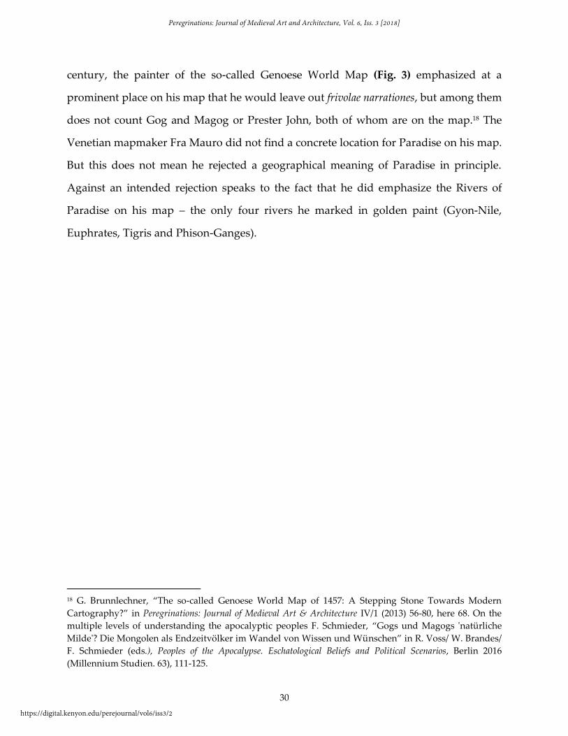
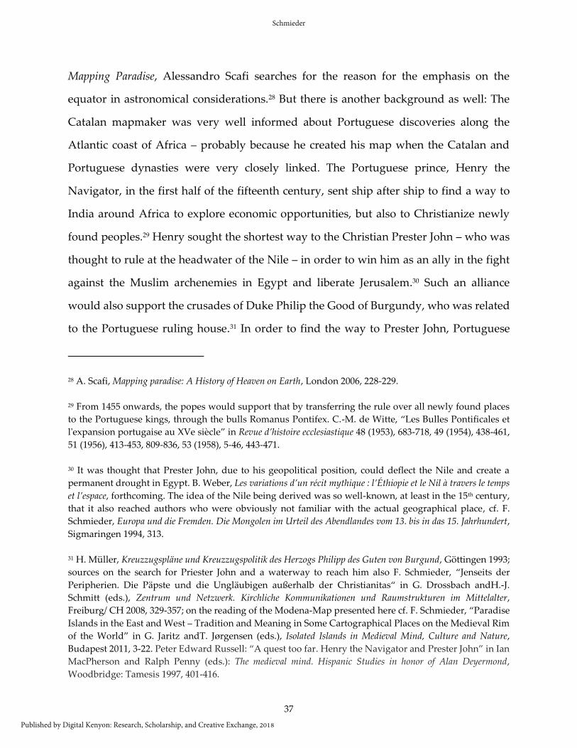
century, the painter of the so-called Genoese World Map (Fig. 3) emphasized at a
prominent place on his map that he would leave out frivolae narrationes, but among them
does not count Gog and Magog or Prester John, both of whom are on the map.18 The
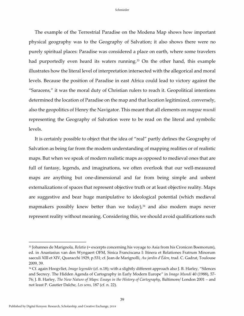
Venetian mapmaker Fra Mauro did not find a concrete location for Paradise on his map.
But this does not mean he rejected a geographical meaning of Paradise in principle.
Against an intended rejection speaks to the fact that he did emphasize the Rivers of
Paradise on his map – the only four rivers he marked in golden paint (Gyon-Nile,
Euphrates, Tigris and Phison-Ganges).
18 G. Brunnlechner, “The so-called Genoese World Map of 1457: A Stepping Stone Towards Modern
Cartography?” in Peregrinations: Journal of Medieval Art & Architecture IV/1 (2013) 56-80, here 68. On the
multiple levels of understanding the apocalyptic peoples F. Schmieder, “Gogs und Magogs 'natürliche
Milde'? Die Mongolen als Endzeitvölker im Wandel von Wissen und Wünschen” in R. Voss/ W. Brandes/
F. Schmieder (eds.), Peoples of the Apocalypse. Eschatological Beliefs and Political Scenarios, Berlin 2016
(Millennium Studien. 63), 111-125.
Peregrinations: Journal of Medieval Art and Architecture, Vol. 6, Iss. 3 [2018]
https://digital.kenyon.edu/perejournal/vol6/iss3/2
31
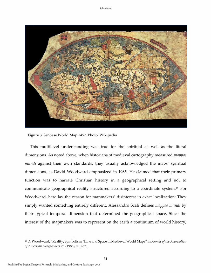
This multilevel understanding was true for the spiritual as well as the literal
dimensions. As noted above, when historians of medieval cartography measured mappae
mundi against their own standards, they usually acknowledged the maps’ spiritual
dimensions, as David Woodward emphasized in 1985. He claimed that their primary
function was to narrate Christian history in a geographical setting and not to
communicate geographical reality structured according to a coordinate system.19 For
Woodward, here lay the reason for mapmakers’ disinterest in exact localization: They
simply wanted something entirely different. Alessandro Scafi defines mappae mundi by
their typical temporal dimension that determined the geographical space. Since the
interest of the mapmakers was to represent on the earth a continuum of world history,
19 D. Woodward, “Reality, Symbolism, Time and Space in Medieval World Maps” in Annals of the Association
of American Geographers 75 (1985), 510-521.
Figure 3 Genoese World Map 1457. Photo: Wikipedia
Schmieder
Published by Digital Kenyon: Research, Scholarship, and Creative Exchange, 2018

32
the spatial dimension was less prominent; or, as he writes, “history rules on
Mappaemundi.”20 Patrick Gautier Dalché has repeatedly objected to these claims and has
shown how much very early mappae mundi could be indebted to reality, how not only the
“symbolic” level of understanding, but also the “real,” the literal interpretation could be
put forward:
Toutes les mappemondes n'ont pas Jerusalém pour centre; toutes ne
mettent pas en scène l'histoire de salut. Et elles n'ont pas pour fonction
essentielle ou unique de présenter à des moines enfermés loin du monde,
ainsi qu'à un public laïc influencé par les valeurs monastiques, une image
de ce monde nécessairement fausse et dépassée (ajoutons, encore une fois,
qu'elles ne montrent pas une terre plate, puisque jamais personne, au
Moyen Âge latin, ne pensa que la terre est plate). Bien au contraire, l'image
regardée, lu et décrite ... (par l'auteur de l'Expositio) ... était ... celle de
l'espace réel et concret….21
20 A. Scafi, “Defining mappaemundi” in P. D. A. Harvey(ed.), The Hereford Map (cf. n. 14), 345-354, here 346-
349.
21 P. Gautier Dalché, “Décrire le monde et situer les lieux au XIIe siècle: l’Exposicio Mappae Mundi et la
généalogie de la mappemonde de Hereford,” Mélanges École franc. Rome, 113 (2001), 343-409, here 376. Cf.
also id., Réalité’ et ‘symbole’ dans la géographie de Hugues de Saint-Victor, in Ugo di San Vittore. Atti del XLVII
Convegno storico internazionale Todi, 10-12 ottobre 2010, Spoleto 2011, 359-81; id., “Les sens de mappa
(mundi) (IVe – XIVe siècles) ” in Archivum latinitatis Medii Aevi 62 (2004), 187-202 .
Peregrinations: Journal of Medieval Art and Architecture, Vol. 6, Iss. 3 [2018]
https://digital.kenyon.edu/perejournal/vol6/iss3/2
33
Indeed, the impression that exact localization was not of primary interest for the
mapmakers means that we can more easily accept the maps’ focus on the moral and
allegorical level than on the literal level, where we cannot seem to stop measuring
meaning and correctness of spatial realities according to our own criteria. But as our
homogeneous understanding of space is not the only one possible, metric representation
Figure 4 Fra Mauro Map. Photo: Wikipedia
Schmieder
Published by Digital Kenyon: Research, Scholarship, and Creative Exchange, 2018
34
is not the only possible form of representation, nor it is any better in principle than, say,
representing more meaningful items as larger than others (which we tend to see as
distorted). We thus tend to implicitly assume that our idea of space is the only one
possible, and that the representations on the mappae mundi, because they obviously do
not fit our idea of a scientific survey, were inaccurate either intentionally or due to
disinterest (or inability). But why should anyone choose pictorial representations if
geography had not been the point? From the fifteenth century, we have the mappemonde
spirituelle by the Burgundian scholar, Jean Germain, which is a textual description of the
world only (at least no map accompanying the text has survived),22 a possible hint that
for the spiritual level the text sufficed, while for a literal one, the map was considered
essential. Therefore, I claim that mappae mundi are not presenting the spiritual history of
salvation on a spatial background that is just passable (because they were not able to do
it better), but the Geography of Salvation in the sense that the physical description of the
earth had basically the very same weight as the generation of salvific sense.
The Geography of Salvation means that past, present, and future were represented
according to their Christian meaning and that the physical, mimetic representation of the
earth as God’s creation had to be as carefully and correctly laid out as possible, according
to contemporary standards. Because since the twelfth century empirical knowledge
became more and more important, most mapmakers of the fourteenth and fifteenth
centuries were eager to adapt their maps as soon as new information and new techniques
became available.
This is even true for the representation of earth as a flat round or oval. Since medieval
mapmakers knew that earth was not a disk, they probably did not imagine anyone
22 Paris, Bibliotheque Nationale, ms. fr. 13235; dedication image (which shows a schematic Mappa Mundi
and thus creates a direct link to the drawn maps) from Lyon, Bibliotheque Municipale, ms. Palais des Arts
32, fol. 1r can be seen in P. Gautier Dalché in Das leuchtende Mittelalter, ed. J. Dalarun, Darmstadt 2005
(French Orig. 2002), 45. Also notifications like mundanus possibly hint to a (virtual) separability: Gautier
Dalché, Décrire, esp. 376 (cf. n. 22).
Peregrinations: Journal of Medieval Art and Architecture, Vol. 6, Iss. 3 [2018]
https://digital.kenyon.edu/perejournal/vol6/iss3/2
35
assuming that they represented it as a disk, just as modern mapmakers do not expect
their users to misunderstand their flat representation as showing a disk. Is there a better
way to project a sphere onto a flat surface if you do not know its measurements? Fra
Mauro left the overall dimensions of God’s creation to the all-knowing creator himself.23
When what is on the back or the downside of the sphere is unknown, the circular map is
a very useful way to represent a sphere on a flat surface.
Not only Fra Mauro, but also other fifteenth-century mapmakers tried to acquire
measurements. As soon as the Portolan technique was known, it was used on mappae
mundi wherever the necessary data were available. Where the data were missing, often
the number of day’s journeys was indicated as makeshift. On the Modena Map, we find
the remark that the Central Asian oasis Lop (known in the west from Marco Polo’s report)
is half-way between Tana (a Venetian colony at the mouth of the Don) and Cathay (Marco
Polo’s northern China), since in each of the two directions merchants needed six months
with their carts.24 Also those contemporaries who were very advanced in the
development of the art of calculation found mappae mundi useful, as has been shown by
Patrick Gautier Dalché for the fourteenth-century Florentine, Paolo d’Abbaco.25
Mapmakers chose the geographical facts they represented on their maps according to
the overall statement they wanted to make, but basically all empirical geographical
knowledge that was properly passed down was deemed presentable. This was true for
Ptolemy and Pomponius Mela, Pliny, Solinus, Macrobius, and Isidore, and also for the
Alexander Romance and the twelfth-century letter of Prester John. We see this also in the
23 P. Falchetta (ed.), Fra Mauro’s World Map, Turnhout 2006 (Terrarum Orbis. 5), nr. 2828: Perhò a l'Eterno
Dio lasso la mesura de la sua opera la qual lui solo intende a ponto ...
24 Mappamondo Catalano Estense, p.145 no. L (cf. n.1).
25 P. Gautier Dalché, “‘Quando vuoli travare la longitudine d'alchuna citta da Occidente, guarda nel
mappamondo da maiolica...’.La mesure des coordonnées géographiques selon Paolo Dell'Abbaco”
Micrologus 19 (2011), 151-200.
Schmieder
Published by Digital Kenyon: Research, Scholarship, and Creative Exchange, 2018
36
travels of the Irish Saint Brendan who had, according to reports, reached several islands
in the Atlantic Ocean that people tried to find again in the fifteenth century – and that
are, in modern scholarship, very often still and wrongly termed fantasy islands.26
We can see the care mapmakers took to align the literal representation of physical
places with their allegorical meaning by returning to the unusual representation of
Paradise on the Modena Map. The caption quoted at the beginning of this article points
us back to the seventh century and Isidore of Seville for the placement of Paradise on the
equator. Isidore begins his book “on the earth and its parts,” and then, after some
introductory materials, proceeds to “de Asia.” After a quick overview over its boundaries,
he lists Asia’s provinces, “starting with Paradise,” which is “a place in the east whose
name, transferred from Greek into Latin, means garden; in Hebrew it is called Eden,
which in our language means ‘delights’ (deliciae) … There is also the Tree of Life. There is
neither cold nor heat but always a well-balanced climate. In the middle a spring
originates … which divides into four rivers …; it is surrounded by a wall of fire reaching
nearly up to the sky ….”27 Isidore is quoted on the Modena Map, but he seems to be the
source only for part of the legend: He does not locate Paradise at the equator, but in the
east. It is highly probably that the mapmaker intentionally modified his source to
accommodate his diversion from the usual placing of Paradise on the maps. In his
26 F. Schmieder, “Der Fall von der Erdscheibe, oder: Wie begrenzt war die Welt im Spätmittelalter?” in
Achim Landwehr (ed.), Grenzerfahrungen, Düsseldorf 2015 (Studia Humaniora. Düsseldorfer Studien zu
Mittelalter und Renaissance. 48), 51-73.
27 Isidore Hispalensis Episcopi, Etymologiarum sive origium libri XX, ed. W. M. Lindsay, Oxford 1911, XIV, 3,
2-4 = Bd. II, 112-113: Paradisus est locus in orientis partibus constitutus cuius vocabulum Paradisus est locus in
orientis partibus constitutus, cuius vocabularum ex Graeco in Latinum vertitur hortus: porro Hebraice Eden dicitur,
quod in nostra lingua deliciae interpretatur. Quod utrumque iunctum facit hortum deliciarum; est enim omni genere
ligni et pomiferarum arborum consitus, habens etiam et lignum vitae: non ibi frigus, non aestus, sed perpetua aeris
temperies. E cuius medio fons prorumpens totum nemus inrigat, dividiturque in quattuor nascentia flumina. Cuius
loci post peccatum hominis aditus interclusus est; septus est enim undique romphea flammea, id est muro igneo
accinctus, ita ut eius cum caelo pene iungat incendium. Cherubin quoque, id est angelorum praesidium, arcendis
spiritibus malis super rompheae flagrantiam ordinatum est, ut homines flammae, angelos vero malos angeli
submoveant, ne cui carni vel spiritui transgressionis aditus Paradisi pateat.
Peregrinations: Journal of Medieval Art and Architecture, Vol. 6, Iss. 3 [2018]
https://digital.kenyon.edu/perejournal/vol6/iss3/2
37
Mapping Paradise, Alessandro Scafi searches for the reason for the emphasis on the
equator in astronomical considerations.28 But there is another background as well: The
Catalan mapmaker was very well informed about Portuguese discoveries along the
Atlantic coast of Africa – probably because he created his map when the Catalan and
Portuguese dynasties were very closely linked. The Portuguese prince, Henry the
Navigator, in the first half of the fifteenth century, sent ship after ship to find a way to
India around Africa to explore economic opportunities, but also to Christianize newly
found peoples.29 Henry sought the shortest way to the Christian Prester John – who was
thought to rule at the headwater of the Nile – in order to win him as an ally in the fight
against the Muslim archenemies in Egypt and liberate Jerusalem.30 Such an alliance
would also support the crusades of Duke Philip the Good of Burgundy, who was related
to the Portuguese ruling house.31 In order to find the way to Prester John, Portuguese
28 A. Scafi, Mapping paradise: A History of Heaven on Earth, London 2006, 228-229.
29 From 1455 onwards, the popes would support that by transferring the rule over all newly found places
to the Portuguese kings, through the bulls Romanus Pontifex. C.-M. de Witte, “Les Bulles Pontificales et
l'expansion portugaise au XVe siècle” in Revue d’histoire ecclesiastique 48 (1953), 683-718, 49 (1954), 438-461,
51 (1956), 413-453, 809-836, 53 (1958), 5-46, 443-471.
30 It was thought that Prester John, due to his geopolitical position, could deflect the Nile and create a
permanent drought in Egypt. B. Weber, Les variations d’un récit mythique : l’Éthiopie et le Nil à travers le temps
et l’espace, forthcoming. The idea of the Nile being derived was so well-known, at least in the 15th century,
that it also reached authors who were obviously not familiar with the actual geographical place, cf. F.
Schmieder, Europa und die Fremden. Die Mongolen im Urteil des Abendlandes vom 13. bis in das 15. Jahrhundert,
Sigmaringen 1994, 313.
31 H. Müller, Kreuzzugspläne und Kreuzzugspolitik des Herzogs Philipp des Guten von Burgund, Göttingen 1993;
sources on the search for Priester John and a waterway to reach him also F. Schmieder, “Jenseits der
Peripherien. Die Päpste und die Ungläubigen außerhalb der Christianitas“ in G. Drossbach andH.-J.
Schmitt (eds.), Zentrum und Netzwerk. Kirchliche Kommunikationen und Raumstrukturen im Mittelalter,
Freiburg/ CH 2008, 329-357; on the reading of the Modena-Map presented here cf. F. Schmieder, “Paradise
Islands in the East and West – Tradition and Meaning in Some Cartographical Places on the Medieval Rim
of the World” in G. Jaritz andT. Jørgensen (eds.), Isolated Islands in Medieval Mind, Culture and Nature,
Budapest 2011, 3-22. Peter Edward Russell: “A quest too far. Henry the Navigator and Prester John” in Ian
MacPherson and Ralph Penny (eds.): The medieval mind. Hispanic Studies in honor of Alan Deyermond,
Woodbridge: Tamesis 1997, 401-416.
Schmieder
Published by Digital Kenyon: Research, Scholarship, and Creative Exchange, 2018

38
ships were not only sent to surround Africa, but also to sail up any larger river whose
mouth was found at the West African coast. Following this order, after 1445, Portuguese
ships sailed up the Gambia that flows into the Atlantic a bit south of the Cape Verde
archipelago, where also our mapmaker, maybe as a consequence of that endeavor, locates
the mouth of the river that shares a headwater with the Nile.
However, the Nile was known to be one of the rivers flowing from Terrestrial Paradise;
in the later Middle Ages, there were many theories about how the Nile could flow from
Paradise in the east to Egypt, where it was known to people.32 The easiest solution
appears on the Modena Map, where the Nile’s course is a central feature, indicating that
the mapmaker tried to bring together different traditions on the course of this river. Since,
according to all other traditions, the Nile was located in Africa, and since the Portuguese
wanted to use the Nile to get to Prester John, the Terrestrial Paradise, its source, had to
move. Moving Paradise itself to Africa, close to Prester John, aligned strategic
considerations with geographical reality.
When we combine Scafi’s idea quoted above of an astronomical reason for Paradise
on the Modena Map and the one just outlined, then recent astronomical considerations
had allowed the relocation of Paradise contrary to all tradition to a place where it could
promote contemporary geopolitical strategic planning by charging it with salvific
relevance (reconquest of the Holy Land, and as ultimate goal Christianization of the
whole world before the Second Coming of Christ). In both cases, it would have meant
that the placement of a traditional and, in terms of salvific history, highly meaningful
place on earth has been significantly adjusted, actualized, and corrected on the basis of
recent considerations of practical politics.
32 As only one example we could take the pilgrim from Cologne, Arnold of Harff (Die Pilgerfahrt des Ritters
Arnold von Harff, ed. Eberhard von Groote, Köln 1860, 148/50) who doubted the identity of the Nile as one
of the rivers of Paradise and also relocated Paradise.
Peregrinations: Journal of Medieval Art and Architecture, Vol. 6, Iss. 3 [2018]
https://digital.kenyon.edu/perejournal/vol6/iss3/2
39
The example of the Terrestrial Paradise on the Modena Map shows how important
physical geography was to the Geography of Salvation; it also shows there were no
purely spiritual places: Paradise was considered a place on earth, where some travelers
had purportedly even heard its waters running.33 On the other hand, this example
illustrates how the literal level of interpretation intersected with the allegorical and moral
levels. Because the position of Paradise in east Africa could lead to victory against the
“Saracens,” it was the moral duty of Christian rulers to reach it. Geopolitical intentions
determined the location of Paradise on the map and that location legitimized, conversely,
also the geopolitics of Henry the Navigator. This meant that all elements on mappae mundi
representing the Geography of Salvation were to be read on the literal and symbolic
levels.
It is certainly possible to object that the idea of “real” partly defines the Geography of
Salvation as being far from the modern understanding of mapping realities or of realistic
maps. But when we speak of modern realistic maps as opposed to medieval ones that are
full of fantasy, legends, and imaginations, we often overlook that our well-measured
maps are anything but one-dimensional and far from being simple and unbent
externalizations of spaces that represent objective truth or at least objective reality. Maps
are suggestive and bear huge manipulative to ideological potential (which medieval
mapmakers possibly knew better than we today),34 and also modern maps never
represent reality without meaning. Considering this, we should avoid qualifications such
33 Johannes de Marignola, Relatio (= excerpts concerning his voyage to Asia from his Cronicon Boemorum),
ed. in Anastasius van den Wyngaert OFM, Sinica Franciscana I: Itinera et Relationes Fratrum Minorum
saeculi XIII et XIV, Quaracchi 1929, p.531; cf. Jean de Marignolli, Au jardin d’Éden, trad. C. Gadrat, Toulouse
2009, 39. 34 Cf. again Hoogvliet, Image legendée (cf. n.18); with a slightly different approach also J. B. Harley, “Silences
and Secrecy. The Hidden Agenda of Cartography in Early Modern Europe” in Imago Mundi 40 (1988), 57-
76; J. B. Harley, The New Nature of Maps: Essays in the History of Cartography, Baltimore/ London 2001 – and
not least P. Gautier Dalche, Les sens, 187 (cf. n. 22).
Schmieder
Published by Digital Kenyon: Research, Scholarship, and Creative Exchange, 2018
40
as “real” or “realistic” with all its semantic ballast for our maps in general and call them
close to nature if that is exactly what we want to say.
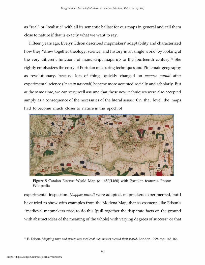
Fifteen years ago, Evelyn Edson described mapmakers’ adaptability and characterized
how they “drew together theology, science, and history in an single work” by looking at
the very different functions of manuscript maps up to the fourteenth century.35 She
rightly emphasizes the entry of Portolan measuring techniques and Ptolemaic geography
as revolutionary, because lots of things quickly changed on mappae mundi after
experimental science (in statu nascendi) became more accepted socially and scholarly. But
at the same time, we can very well assume that those new techniques were also accepted
simply as a consequence of the necessities of the literal sense: On that level, the maps
had to become much closer to nature in the epoch of
experimental inspection. Mappae mundi were adapted, mapmakers experimented, but I
have tried to show with examples from the Modena Map, that assessments like Edson’s
“medieval mapmakers tried to do this [pull together the disparate facts on the ground
with abstract ideas of the meaning of the whole] with varying degrees of success” or that
35 E. Edson, Mapping time and space: how medieval mapmakers viewed their world, London 1999, esp. 165-166.
Figure 5 Catalan Estense World Map (c. 1450/1460) with Portolan features. Photo:
Wikipedia
Peregrinations: Journal of Medieval Art and Architecture, Vol. 6, Iss. 3 [2018]
https://digital.kenyon.edu/perejournal/vol6/iss3/2
41
the Atlas Catalan (1375) showed an “impressive attempt” to adapt are too hesitant. The
fifteenth and sixteenth centuries saw further adaptations that combined meaning and
geographical experience, and the maps in question are not at all clearly separate from the
“cartographic mainstream,” which, in Edson’s estimate, had chosen clearly different
paths of developing their art of mapmaking from the fourteenth century onwards.
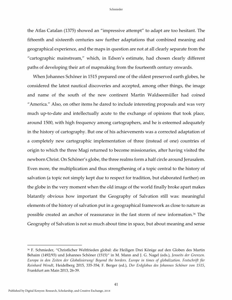
When Johannes Schöner in 1515 prepared one of the oldest preserved earth globes, he
considered the latest nautical discoveries and accepted, among other things, the image
and name of the south of the new continent Martin Waldseemüller had coined
“America.” Also, on other items he dared to include interesting proposals and was very
much up-to-date and intellectually acute to the exchange of opinions that took place,
around 1500, with high frequency among cartographers, and he is esteemed adequately
in the history of cartography. But one of his achievements was a corrected adaptation of
a completely new cartographic implementation of three (instead of one) countries of
origin to which the three Magi returned to become missionaries, after having visited the
newborn Christ. On Schöner’s globe, the three realms form a half circle around Jerusalem.
Even more, the multiplication and thus strengthening of a topic central to the history of
salvation (a topic not simply kept due to respect for tradition, but elaborated further) on
the globe in the very moment when the old image of the world finally broke apart makes
blatantly obvious how important the Geography of Salvation still was: meaningful
elements of the history of salvation put in a geographical framework as close to nature as
possible created an anchor of reassurance in the fast storm of new information.36 The
Geography of Salvation is not so much about time in space, but about meaning and sense
36 F. Schmieder, “Christlicher Weltfrieden global: die Heiligen Drei Könige auf den Globen des Martin
Behaim (1492/93) und Johannes Schöner (1515)“ in M. Mann and J. G. Nagel (eds.), Jenseits der Grenzen.
Europa in den Zeiten der Globalisierung/ Beyond the borders. Europe in times of globalization. Festschrift für
Reinhard Wendt, Heidelberg 2015, 335-354; F. Berger (ed.), Der Erdglobus des Johannes Schöner von 1515,
Frankfurt am Main 2013, 26-39.
Schmieder
Published by Digital Kenyon: Research, Scholarship, and Creative Exchange, 2018
42
of the time in space – and thus mappae mundi only finally lost their function when in
scientific cartography the earth as God’s creation in general was up for renegotiation.
It should be again obvious in this last example taken from a new age of cartography
that mappae mundi, according to the Geography of Salvation (and in this I include
Schöner’s globe) were anything but static products. In principle, all four levels of meaning
might be present at any time and have to be considered, but each of them could be
stronger or weaker in different mappae mundi, could be emphasized or left out. Mappae
mundi that go beyond the simple T-O pattern were idiosyncratic products of mapmakers
with different representational goals and audiences, who were also in discursive dispute
with other mapmakers. The Geography of Salvation provided them with a complex
semiotic web that, ideally, allowed their maps to be read on the four different levels of
the sensus scripturae: the literal, moral, allegorical, and eschatological. That is the yardstick
with which to measure western medieval mappae mundi.
Figure 6 Johannes Schöner Globe, 1515.
Photo: https://etc.usf.edu/maps/pages/2400/2455/2455.htm
Peregrinations: Journal of Medieval Art and Architecture, Vol. 6, Iss. 3 [2018]
https://digital.kenyon.edu/perejournal/vol6/iss3/2