Embed Size (px)
Citation preview

Geography and Environmental Science
Title of Course
Unit: Environmental geoinformatics
Classes per week: 2 Credit value: 3 Type: exercise
Prerequisites:
At least initial level GIS knowledge.
Course description:
The aim of the course is to develop the GIS knowledge gained in the undergraduate course, closely related to their
themes. During the lesson one of the functions of the ArcGIS software is described, and examples of practical life
will be solved.
• Comparative analysis of vector and raster files. Hybrid Systems. The possibilities and difficulties of raster - vector
conversion, the review of the digitization (vectorization) methods.
• Problems and solutions to raster georeferencing.
• Problems and solutions to vector georeferencing.
• Overview and preprocessing of vector data from a CAD source (file format, drawing layers, object types). An
overview of attribute data.
• Overview of official files in the CAD format used in Hungary (real estate and forestry land cadaster registers,
utilities, etc.)
• Import vector database, then convert object types (e.g. line-polygon conversion).
• Attribution of objects based on different object types, with particular regard to official sources available in Hungary.
• Theoretical and practical implementation of topology improvement.
• Advanced capabilities for mapping data.
• Actions in the Vector Database: Classify Data, Manual and Automatic Reclassification, Query Operations (SQL).
• Operations in the database, simpler programming tasks.
• Advanced features of a digital elevation model.
• Creating and pre-processing raster files from a standard (paper-based) data source.
• Criteria for evaluating open source raster maps and their use.
Instructor: Dr. Zoltán Utasi
Language of instruction: English
Semester: 1.
Readings:
Bernhardsen, T. (1999): Geographic Information System. John Wiley & Sons Inc., New York. P. 407,
ISBN 0471321923
ESRI (2012): ArcGIS I: Introduction to GIS (Student edition). (digital user manual, p. 303)
ESRI (2012): ArcGIS II: Essential workflows (Student edition). (digital user manual, p. 393)
Requirements and grading:
Based on raw basic data, creating a real GIS database with independent work.
Földrajz és Környezettudomány 1

Geography and Environmental Science
Title of Course
Unit: Agricultural meteorology
Classes per week: 2+2 Credit value: 2 Type: lecture+seminar
Prerequisites:
None
Course description:
Atmospheric characteristics as a basic information in agricultural meteorology,
Solar energy, physical properties and basic lows of solar energy transformation in the atmosphere, features of solar
climate of Hungary
Air movement in the atmosphere, role of wind speed and wind direction in agricultural production
Heat management of different soils. Temperature profiles in the soil and atmosphere
Air humidity, types of its expression, annual and daily distribution of air humidity
Soil moisture, types of its expression, time and spatial distribution of soil moisture
Precipitation types, annual distribution of Hungary
Evaporation, transpiration, potential evaporation
Micrometeorology, factors and characteristics of microclimate
Atmosphere-vegetation-soil interactions
Water resources, water balance calculations, methods of irrigation and drainage
Management and analysis of agro-climatic data base, specific indices of agro-climatology
Crop requirements, temperature and crop development
Instructor: Dr. László Lakatos
Language of instruction: English
Semester: 2. (lecture);3.(seminar)
Readings:
Attri, S. D., Rathore, L. S., Sivakumar, M. V., & Dash, S. K. (Eds.). (2011). Challenges and opportunities in
agrometeorology. Springer Science & Business Media.
Sivakumar, M. V., & Motha, R. P. (Eds.). (2008). Managing weather and climate risks in agriculture.
Springer Science & Business Media. Stigter, K. Applied Agrometeorology; Springer: Heidelberg/Berlin, Germany/New York, NY, USA, 2010.
Requirements and grading:
- Participation on the 80% of the lectures
- Essay on a chosen subject (10-15 pages) and oral presentation (30 minutes) about another special topic.
Földrajz és Környezettudomány 2

Geography and Environmental Science
Title of Course
Unit: Atmosphere as risk and resource
Classes per week: 2+2 Credit value: 2+2 Type: Lecture + practice
Prerequisites:
None
Course description:
Content:
Weather and climate. Resources and risks. Spatial and temporal characteristics of atmospheric motion
systems. Main circulatory objects of the atmosphere.
Key process of dangerous weather phenomena: convection (vertical updraft). Role of convection in
particular atmospheric objects.
Characteristics of temperate zone: planetary waves, cyclones, anticyclones. Role of mesoscale formations in
the intensity of weather fronts.
Tropical cyclones (hurricanes), tornados, other mesoscale or convective systems.
Atmosphere as a resource for water supplies, natural and cultivated vegetation cover, transport, construction
and human life.
Atmosphere as the transmitter of the majority of renewable sources of energy: solar energy, wind power.
Estimation of the supplies of renewable sources of energy. Effects on hydro power and biomass.
General features of the atmosphere as a resource in Hungary and in major climatic districts. Comparison
with spatial and temporal density of other energy forms.
Atmosphere as a risk-factor. Risks related to the physical state of the atmosphere in the decreasing order of
space-time scale. The most important effects of these formations on animate and inanimate nature, on man
itself and on the elements of our man-made environment.
Droughts, severe frosts, heat waves, late spring frosts, huge convective increase of wind, constant and heavy
rainfalls, sudden melt, floods, hails etc.
Tools of scientific forecast of dangerous weather phenomena, their possibilities and constraints. Theoretical
fundamentals and prospects of averting hails, dissolving clouds and gaining precipitation.
Characteristics of chemical components of air. Global, continental, regional, local and town-scales. Air
quality monitoring networks.
Air quality problems of modern age in Hungary, in the developed world and in districts with backward
technologies. Harmful chemical effects of polluted air.
Methods: Lectures, online illustrations, presentations. Instructor: Prof. Dr. János Mika, full professor
Language of instruction: English
Semester: 3. (lecture) and 4. (practice)
Readings:
BURT, C.C., 2007: Extreme Weather. W.W. Norton and Company, New York, N.Y., 304 p.
FOKEN, T., 2008: Micrometeorology. Springer Berlinm, Heidelberg, 308 pp.
MIKA, J., 2014: Atmosphere as risk and resource. Lecture notes for Geography MSc students. 140 pages, 291,8
KiloN http://p2014-1.palyazat.ektf.hu/tananyagok
HENSON R., (2002): Rough Guide on Weather. Rough Guides Ltd.. 416 pp.
POTTER TH. D. AND COLMAN B. R., (eds), (2003): Handbook of Weather, Climate and Water. Dynamics,
Climate, I. Physical Meteorology, Weather Systems and Measurements. 973 pp., II. Atmospheric Chemistry,
Hydrology, and Societal Impacts. 966 pp.
GOS (2010): Manual on the Global Observing System: Vol. I, Global aspects. WMO Geneva
ftp://ftp.wmo.int/Documents/MediaPublic/Publications/WMO544_GOSmanual/544_Vol_I_2010_en.pdf
GOS (2011): Manual on the Global Observing System: Vol.II, Regional aspects WMO Geneva
ftp://ftp.wmo.int/Documents/MediaPublic/Publications/WMO544_GOSmanual/544_II_2011_en.pdf
NOAA (2010) NWS JetStream – Present Weather Symbols. National Oceanic and Atmospheric Administration.
http://www.srh.noaa.gov/jetstream/synoptic/ww_symbols.htm.
Requirements and grading:
- Participation on the 80% of the lectures
-Essay on a chosen subject (10-15 pages) and oral presentation (30 minutes) about another special topic.
Földrajz és Környezettudomány 3

Geography and Environmental Science
Title of Course
Unit:
Catastrophe protection and damage recovery
Classes per week: 2 Credit value: 2 Type: practical
Prerequisites:
theoretical classes of this course
Course description:
The important laws and the national organization and system of the disaster management in Hungary. The basic
function of the National Directorate General for Disaster Management is protecting the lives and the property of the
population living in Hungary and insuring the safe operation of the national economy and protecting the elements of
the critical infrastructure. The most important works are: civil and local protection in the country and in the local
governments; fire protection; industrial safety especially by hazardous material and unsafe works and participation
on the chimney-sweep.
Involvement in the team-work’s training floodwater protection which is organization every three years in the selected
settlement.
Instructor: Tamás Misik
Language of instruction: english
Semester: 2017/2018/2 (spring)
Readings:
Coppola, D. 2015. Introduction to International Disaster Management. Elsevier, ISBN 9780128014776, pp.
760.
Kirschenbaum, A. 2003. Chaos Organization and Disaster Management. CRC Press, ISBN 9780824747152,
pp. 336.
Pinkowski, J. 2008. Disaster Management Handbook. CRC Press, ISBN 9781420058628, pp. 624.
Requirements and grading:
-regular participation on the classes and on the other business
-on the basis of the quality of the poster presentation and of the quality of the presentation
Földrajz és Környezettudomány 4

Geography and Environmental Science
Title of Course
Unit: Geographycal analyses of environmental systems
Classes per week: Credit value: 2 Type: seminar
Prerequisites:
Geographycal analyses of environmental systems I.
Geographycal analyses of environmental systems
Course description:
The coarse summarize the main environmental systems (geospheres) of Earth on a complex way:
Lithosphere
Hydrosphere
Biosphere
Pedosphere
Beach systems
Deserts – eolian systems
Glacial systems
Antropogenic system
Erosional systems
Instructor: Dr. Polgári Márta
Language of instruction: English
Semester: 2017/2018/2 (spring)
Readings:
Treatise on Geochemistry volumes 1-16 (9144 pp) Editors: Karl TurekianHeinrich Holland eBook ISBN: 9780080983004
2013 Hardcover ISBN: 9780080959757
Requirements and grading:
Participation on lessons
Homework of chosen subject (10-15 pages) and presentation (30 minutes)
Földrajz és Környezettudomány 5

Geography and Environmental Science
Title of Course
Unit: Physical and chemical interactions in the geosphere
Classes per week: 2 Credit value: 2 Type: lecture
Prerequisites:
None
Course description:
Biogeochemical cycles provide the basic framework for investigating global change and its implications for life on
earth. An understanding of biogeochemical cycles and anthropogenic impacts on them is fundamental for predicting
impacts of global climate change.
The global biogeochemical cycles of many elements have been altered by human (anthropogenic) activity
Biogeochemical cycles operate on many different spatial and temporal scales.
A reservoir is a physically well-defined system. A given setting with defined physical and/or biological boundaries.
Fluxes transfer of matter from one reservoir to another. A flux into a reservoir is sometimes referred to as a source, a
flux out of the reservoir as a sink. Material transfers. Residence times for different elements. Mass balance. Non
steady state conditions. In many instances the source and sink rates are not constant with time. Box models -
Reservoirs and Fluxes. Changes in the water Cycles. Features of carbon cycle. The nitrogen cycle. Sulfur cycle.
Feedbacks in the Climate System.
Instructor: Dr. László Lakatos
Language of instruction: English
Semester: 2017/2018/2 (spring)
Readings:
Bonan, G. (2015). Ecological climatology: concepts and applications. Cambridge University Press.
Brasseur, G. P., & Prinn, R. G. (2003). Atmospheric Chemistry in a Changing World: An Integration and Synthesis
of a Decade of Tropospheric Chemistry Research; the International Global Atmospheric Chemistry Project of the
International Geosphere-Biosphere Programme; with 22 Tables. Springer Science & Business Media.
Crossland, C. J., Kremer, H. H., Lindeboom, H., Crossland, J. I. M., & Le Tissier, M. D. (Eds.). (2005). Coastal
fluxes in the Anthropocene: the land-ocean interactions in the coastal zone project of the International Geosphere-
Biosphere Programme. Springer Science & Business Media.
Manahan, S. (2017). Environmental chemistry. CRC press.
Requirements and grading:
- Participation on the 80% of the lectures
- Essay on a chosen subject (10-15 pages) and oral presentation (30 minutes) about another special topic.
Földrajz és Környezettudomány 6

Geography and Environmental Science
Title of Course
Unit: Vegetation as risk and resource
Classes per week: 2 Credit value: 2 Type: lecture
Prerequisites:
None
Course description:
The living world is responding to climate change, Climate change might allow exploration of new species and
varieties Food availability is having available sufficient quantities of food on a consistent basis. Projected changes in
crop yields at different latitudes with global warming. Historical Increase in Extreme Events in different cultivation
areas. The Risk of Heat Stress, Drought and Heavy Rains. Food access is having sufficient resources, both economic
and physical, to obtain appropriate foods for a nutritious diet. Food use is the appropriate use based on knowledge of
basic nutrition and care, as well as adequate water and sanitation. The stability of the first three dimensions of food
security over time. Adapting to climate change. Farm-level adjustments that build resilience. New varieties, new
crops, change planting dates. Diversify cropping systems at farm and regional scales. Develop new strategies for new
pests, diseases and weeds. Improve soil resilience to drought and flooding. Expand into new sites less prone to water
stress. New irrigation and drainage systems. Fruit crop frost protection (site selection, misting, air circulation).
Improve cooling capacity of livestock facilities. Agriculture Adaptation (Beyond the farm). Renewable Energy
on the Farm.
Instructor: Dr. László Lakatos
Language of instruction: English
Semester: 2017/2018/2 (spring)
Readings:
Baeza, M. J., Raventós, J., Escarré, A., & Vallejo, V. R. (2006). Fire risk and vegetation structural dynamics in
Mediterranean shrubland. Plant Ecology, 187(2), 189-201.
Cape, J. N. (1993). Direct damage to vegetation caused by acid rain and polluted cloud: definition of critical levels
for forest trees. Environmental pollution, 82(2), 167-180.
Eamus, D. (2006). Ecohydrology: vegetation function, water and resource management. Csiro Publishing.
Milesi, C., Hashimoto, H., Running, S. W., & Nemani, R. R. (2005). Climate variability, vegetation productivity
and people at risk. Global and Planetary Change, 47(2-4), 221-231.
Sivakumar, M. V., & Motha, R. P. (Eds.). (2008). Managing weather and climate risks in agriculture. Springer
Science & Business Media.
Requirements and grading:
- Participation on the 80% of the lectures
-Essay on a chosen subject (10-15 pages) and oral presentation (30 minutes) about another special topic.
Földrajz és Környezettudomány 7

Geography and Environmental Science
Title of Course
Unit: Waste management
Classes per week: 2 Credit value: 2 Type: theoretical
Prerequisites:
nothing
Course description:
The different is between waste and garbage. The priority succession on the waste management. Definition of the
refuse and the recycling, the potential forms of the disposal. The general attitude of the hungary waste management.
Demonstration of the National Waste Plan and demonstration of the statue of 2000th XLIII. from waste management
and new statue of 2012th CLXXXV. from waste.
The environmental programme of European Union (chapters of waste management). The hungarian request for respite
on the waste management.
Closure, liquidation and rekultivation of the landfill. The educational possibility of the waste management
fundamentals. Projects, open days and citizen information. Waste of formation, the waste-conscious purchase. The
prevention of the waste formation.
Economic questions and the waste of private have bearing on treatment. The definition and great importance of
benchmark. The returnable, the depository and the product fee. The detailed demonstration of the hungarian landfills.
The detailed function, infrastructural facilities and set-up of the home regional landfills.
The home burning of waste. The modern waste-burning, the incineration. The type and functional pattern of refuse
burner. The system of waste selection in Hungary and in the world. Demonstration of the german system. The
junkyard and the waste selection containers. The great important of the sorter halls.
The recycling of the organic waste materials; the methods, the process and the important rules of the composting.
Instructor: Tamás Misik
Language of instruction: english
Semester: 2017/2018/2 (spring)
Readings:
Johnson, B. 2013. Zero Waste Home: The Ultimate Guide to Simplifying Your Life by Reducing Your
Waste. Scribner Publish, pp. 304.
Tchobanoglous, G., Kreith, F. 1994. Handbook of Solid Waste Management. McGraw-Hill Handbooks, pp.
950.
Unnisa, S.A., Rav, S.B. 2012. Sustainable Solid Waste Management. Apple Academic Press, ISBN
9781926895246, pp. 190.
Requirements and grading:
-regular participation on the classes and on the other business
-on the basis of the quality of the poster presentation and of the quality of the presentation
Földrajz és Környezettudomány 8

Geography and Environmental Science
Title of Course
Unit: The geography of globalization
Classes per week: 2 Credit value: 3 Type: lecture
Prerequisites:
Intermediate English language skills.
Course description:
The purpose of this subject is to show the revised ideas on space and spatialities in consequence
of the development of communication, the spreading of technical civilisation and after all the
fulfillment of globalisation and to introduce into the related research possibilities.
The aim of the course is to survey new problems and paradigms about space implicated by
globalisation. Economic geography has to concentrate on a borderless hyper-market where the
role of computer-based communication is crucial. Beside globalisation at micro-regional and local
level localisation is an important counter-process: the building and management of local identity.
The new word “glocalisation” (globlocalisation) comes from the globalisation-localisation
opposite concepts. The apparently opposite concepts dissolve and harmonize as follows:
Integration into the global processes with the preservation of identity and values accumulated up
to the present. The main topics are as follows:
1. The definition of globalization
2. A historical approach of recent globalization
3. Economy and globalization
4. Politics in a global context
5. The cultural effect of globalization
6. Globalism – an ideology
7. The environmental side of globalization
8. Counter-globalization
Instructor: Csaba Patkós, PhD
Language of instruction: English
Semester: Spring
Readings:
Compulsory readings:
Klein, N. (2001): No Logo. – Flamingo, 490 p.
Steger, B. M. (2013):Globalization: A Very Short Introduction. – Oxford University Press
151 p.
Vertova, G. (2006): The Changing Economic Geography of Globalization. – Routledge,
272 p.
Recommended readings:
Bauman, Z. (2000): Globalisation The Human Consequences. - Columbia University Press
160 p.
Giddens, A. (2002): Runaway World: How Globalisation Is Reshaping Our Lives. –
Routledge 100 p.
Massey, D. (1999): Human geography today. Polity Press, Cambridge 352 p.
Requirements and grading:
Földrajz és Környezettudomány 9

Geography and Environmental Science
Students must attend lectures and create an organized personal course diary containing relevant information on each
main course topics. Additionally a 2500 words long essay should be written in English in one of the above themes.
Both works contribute to the final grade given by tutor at the same rate (50-50%).
Földrajz és Környezettudomány 10

Geography and Environmental Science
Title of Course
Unit: Regional and spatial development
Classes per week: 2 Credit value: 3 Type: lecture
Prerequisites:
Intermediate English language skills.
Course description:
The aim of the course is to introduce students to the stunning world of geography-sensitive socio-
economic development theories and their implementation in different environments. The main
topics are as follows:
1. Definition and bases of regional development
2. Theories of local and regional development
3. Development with exogenous resources
4. Mobilising indigenous potential
5. Population and development
6. Technology and development
7. The regional policy of the European Union
8. Government and governance in development – institutionalization
9. Asset Based Community Development
10. The EU’s LEADER approach
Instructor: Csaba Patkós, PhD
Language of instruction: English
Semester: Autumn
Readings:
Compulsory readings:
Pike, A. – A. Rodriguez-Pose, J. Tomaney (2006): Local and Regional Development. –
Taylor & Francis 312 p.
Szirmai, A. (2015): Socio-economic development. – Cambridge University Press 794 p.
Recommended readings:
Sen, A. (2000): Development as freedom. – Anchor 384 p.
White, S. – M. Gasser (2011): Local economic development: a tool for supporting locally
owned and managed development processes that foster the global promotion of decent
work. Geneva: ILO. Job creation and enterprise development
Requirements and grading:
Students must attend lectures and create an organized personal course diary containing relevant information on each
main course topics. Additionally a 2500 words long essay should be written in English in one of the above themes.
Both works contribute to the final grade given by tutor at the same rate (50-50%).
Földrajz és Környezettudomány 11

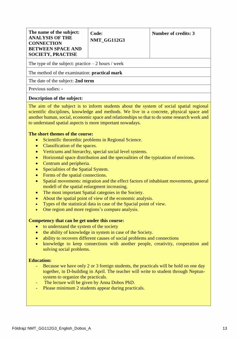
The name of the subject:
ANALYSIS OF THE
CONNECTION
BETWEEN SPACE AND
SOCIETY, PRACTISE
Code:
NMT_GG112G3
Number of credits: 3
The type of the subject: practice – 2 hours / week
The method of the examination: practical mark
The date of the subject: 2nd term
Previous sudies: -
Description of the subject:
The aim of the subject is to inform students about the system of social spatial regional
scientific disciplines, knowledge and methods. We live in a concrete, physical space and
another human, social, economic space and relationships so that to do some research work and
to understand spatial aspects is more important nowadays.
The short themes of the course:
Scientific theorethic problems in Regional Science.
Classification of the spaces.
Verticums and hierarchy, special social level systems.
Horizontal space distribution and the specoalities of the typization of environs.
Centrum and peripheria.
Specialities of the Spatial System.
Forms of the spatial connections.
Spatial movements: migration and the effect factors of inhabitant movements, general
modell of the spatial enlargment increasing.
The most important Spatial categoies in the Society.
About the spatial point of view of the economic analysis.
Types of the statistical data in case of the Spacial point of view.
One region and more regions’s compare analysis.
Competency that can be get under this course:
to understand the system of the society
the ability of knowledge in system in case of the Society.
ability to recovers different causes of social problems and connections
knowledge to keep connections with another people, creativity, cooperation and
solving social problems.
Education:
- Because we have only 2 or 3 foreign students, the practicals will be hold on one day
together, in D-building in April. The teacher will write to student through Neptun-
system to organize the practicals.
- The lecture will be given by Anna Dobos PhD.
- Please minimum 2 students appear during practicals.
Földrajz NMT_GG112G3_English_Dobos_A 13

ANALYSIS OF THE CONNECTION BETWEEN SPACE AND SOCIETY,
PRACTISE Teacher: Anna Dobos PhD.
Dates Themes
April/2018.
Introduction. Speaking about the Description of this subject.
Scientific theorethic problems in Regional Science.
Classification of the spaces.
Verticums and hierarchy, special social level systems.
Horizontal space distribution and the specialities of the
typization of environs.
Centrum and peripheria.
Specialities of the Spatial System.
Forms of the spatial connections.
Spatial movements: migration and the effect factors of
inhabitant movements, general modell of the spatial
enlargment increasing.
The most important Spatial categoies in the Society.
About the spatial point of view of the economic analysis.
Types of the statistical data in case of the Spacial point of
view.
One region and more regions’s compare analysis.
Giving the mark of this subject
About this course:
- Students need to take part in these practicals in active position during consultation
and speaking the scientific basis and scientific social problems and cases.
References:
References:
NEMES NAGY JÓZSEF (2009): Terek, helyek, régiók (A regionális tudomány alapjai).
Akadémiai Kiadó, Bp., 350 p. (ISBN 978 963 05 8656 6)
NEMES NAGY JÓZSEF (1998): A tér a társadalomkutatásban. Hilscher Rezső
Szociálpolitikai Egyesület, Bp., 259 p. ISBN 963 03 4921 3,
and other articles from ELSEVIER journals
Responsible person for the subject: Dr. Patkós Csaba PhD.
Teacher: Dr. Dobos Anna PhD.
Földrajz NMT_GG112G3_English_Dobos_A 14

The name of the subject:
Modern Research Methods in Geography -
practise
Code:
NMT_GG100G2 Credit: 2
The type of subject (lecture/practise) and numbers /week: practise, 2/30
methods for valuation: practise mark
The place of the subject (which term/semester): 1st semester/term
Frequency: in every 1st semester/term
Language of this subject (if non-Hungarian): English
Former subjects: -
Description of the subject
The aim of this course:
The „Modern Research Methods in Geography” subject is inside our Educational
system because students will be able to get new information using national and
international publications, journals, electornic websites, libaries, and modern scientific
methods in fields and GIS methods. Students can know new physical geographical,
social and economic geographical information and investigation methods during this
course. After that they will be able to structure their scientific papers, Diplomas and
etc.
This subject can prepare students to the requirements of writing and structuring MSc
Diploma while they can study lot of new information about modern physical, social
and economiv geographical research methods.
This subject can develop the knowledge, logical ability, complex thinking, problem
solving, structure, grammar and writing ability. This subject can develop our students
very well in such an ability and capability which are good basis for creating new
settlement development plans, touristic plans or another publications and scientific
paper.
The lecturer want that students can use these knowledge of modern research methods,
developed abilities and capabilities during another lectures, practices and their every
days.
The aim of this subject is to show the modern research methods in Geography
(Physical, Social and Economic Geography), the national and international
requirements for publications, structuring scientific papers, and oral presentations.
Developing competitions:
During this course, our students will study new information of national and
international publication habits, requirements of oral presentations, requirements of
MSc Diploma, the modern field works (investigation of Quaternary sediments, soil
descriptions based on FAO (2006) soil description method, geomorphological
mapping procedure, meteorological stations) in Physical Geography; and Social and
Economic Geographical research methods (creating database, creating different maps
and diagrams, SWOT analysis, valuation of scientific data, etc.).
The logical thinking, ability of complex problem solving, writing skills and ability of
oral preentation will develope during this course. The lecturer will tone practical
thinking, complex knowledge of Geographical research methods and problem
solvings.
Földrajz Research methods_Dobos_A 15

After this course, students will able to use their new knowledge of field works, maps,
soil investigations, etc. to analyse physical, social and economic geographical
conditions of settlements and valuating of settlement development palns.
Students can give better performance in writing skills, structuring of scientific papers
and oral presentations. They will able to work with different scientific databases, to
valuate them and to use field research methods during their own research work.
This subject built former topographical, physical geographical and socio-economic
geographical knowledges and experiences of former field trips during BSc courses.
Content and planned lessons/tasks:
We will deal with the following themes during our courses: references in publications,
Publucations and oral presentations in modern Earth science, databases for thematic
maps, built up different database, geomorphological mapping, field work for kowing
of Quaternary sediments, OSL investigations, landscape development analysis, soil
description methods based on Hungarian and WRB soil classification system (FAO
2006, 2014), meteorological data, OMSZ database, drainage/water databases, land-use
changes and analysis based on Military Survey Maps, Arcanum database, natural and
cultural heritage (unique landscape values) in settlements (HS 20381/2009), Modern
Research Methods in Social and Economic Geography (interviews, questionaries,
SWOT analysis, etc.) and valuation of potential resources in settlements.
During this course, our students will work on own scientific theme based on a choosen
settlement while they will able to develope their knowledge of different kinds of
research methods.
Date Titles for practices 12/09/2016. Introduction. Knowledge of themes for modern geographical reseach
methods.
19/09/2016. Knowledge of Physical Geography:
topographic site for the investigated settlement
geological conditions for the investigated settlement
relief conditions/geomorphological characters for the investigated settlement
soil conditions for the investigated settlement
drainage system for the investigated settlement
climatic conditions for the investigated settlememnt Kowlegde of Social and Economic geography:
landscape and settlement history
social conditions for the investigated settlement
economic conditions and possibilities for the investigated settlement
natural and cultural heritage in the investigates settlement
potential resources for the investigated settlement
proposals for development strategy in the investigates settlement, SWOT analysis, settlement development plan
giving letures …..during practices ……based on a choosen settlement in Hungary (Cserépfalu).
student publication and oral presentation (ppt-presentation). to choose a suitable settlement for investigating.
26/09/2016. References in the modern geographical publications:
websites, journals, and possibilities for looking for references,
applied libraries in websites thorough our University Library.
Földrajz Research methods_Dobos_A 16

Electronic Open Asses Journals in websites and books in Library.
Journals and articles: Guide for Authors, Article Structure, Essential title age information, Abstract, Keywords, Math formula, Electronic artwork, Tables and Figures, References, Research data. – in different Hungarian and foreign journals.
3/10/2016. Databases for Maps. Valuation of relief data: GIS - SURFER 9.0, Geomorphological mapping and useage of Military Survey Maps for physical geographical investigations and landscape history/development.
10/10/2016. Field investigation methods for Quaternary sediments, OSL investigations, Geomorphological mapping during field works. – Alanysis for Landscape Development, Methods for relief valuation.
17/10/2016.
Soil description methods based on Hungarian and FAO soil classification system, Meteorological data, data from the Hungarian Meteorological Service (OMSZ), Water databases in Hungary.
24/10/2016. Military Survey Maps, CLC 1990, CLC 2012 – Investigation of Land-use system since 18th century to nowadays, settlement history analysis based on the Arcanum Database.
31/10/2016. – 1/11/2016
AUTUMN HOLIDAY FOR STUDENTS AND
7/11/2016. Natural and Cultural heritage in settlements (nature conservation): Methods for survey of Unique landscape values (HS 20381/2009).
14/11/2016. Investigation methods in Social Geography.
21/11/2016. Investigation methods in Economic Geography. Exploring of local potential resources.
28/11/2016. Students’ presentation about their investigations based on a chosen settlement (ppt-presentation, 15 minute oral presentation)
Deadline for the 15 page student publication (222. room in D-building).
5/12/2016. Students’ presentation about their investigations based on a chosen settlement (ppt-presentation, 15 minute oral presenttaion)
12/12/2016. Valuation of student works.
Organization of Education:
Practices will hold at D-building of Eszterházy Károly University (Leányka Street
6.) between 10.00 – 11.40 a.m. in Monday in 222. room.
There will be field works during our practices too so that field clothes recommended
to wear during these field trips. We recommend for students to appear 3 minutes before
the practices at room 222, D-building.
Conditions for good marks:
Students need to appear in the practices (look at Educational Orders). They need to
structure a 15 page publication about a chosen settlement and to give a student 15
minutes ppt-oral presentation about their investigated settlement.
Students can get good mark when they could do their duty during this term. Students
can get mark of (2) when they can reach 51% of our requirements.
Students will get their marks based on the following system: (5 – jeles): 100 – 90%, (4
– jó): 89 – 77%, (3 – közepes): 76 – 64%, (2 – elégséges): 63 – 51%.
The student’s 15 page publication, oral presentation and field works will be qualified
by the associated professor.
Students will get their marks in the last week of this educational term/semester.
Methods for valuation:
Földrajz Research methods_Dobos_A 17

o Minimum expectation that students appear in practices during the educational
term (look at Educational Orders), they will structure a 15 page publication
about a chosen settlement and an 15 minute oral presentation.
o marks based on the following system : (5 – jeles): 100 – 90%, (4 – jó): 89 –
77%, (3 – közepes): 76 – 64%, (2 – elégséges): 63 – 51%.
o The requirements will be valuated by the college associate professor and the
marks will be closed in the last week of this educational term.
Requirements during this term:
o Students will work on the complex description and landscape factor valuation
of a chosen settlement parallel to our practices / lectures.
o There will go to field works during our ptactices as well, the date of field works
will be harmonized by the college associate professor.
o Students give an oral presentation in 28/11/2016 or 5/12/2016. The deadline
for the student publication will be in 28/11/2016.
Oral examination:
o We have not got an oral examination in this subject.
References:
- References will discussed with students based on a chosen settlements for the
investigation.
Director of Specialisation: Prof. dr. János Mika, professor, Head of Department of
Environmental Sciences and Landscape Ecology, [email protected]
Responsible person for this subject: Dr. Antal Tóth, college associate professor,
Deapartment of Social Geography and Region Development, [email protected]
Lecturer: Dr. Anna Dobos, college associate professor, Department of Environmental
Sciences and Landscape Ecology, [email protected]
Place where students can speak with the lecturer:
Dr. Anna Dobos – Monday: 8.00 – 9.00, or Tuesday: 10.00 – 11.00; D-building (Leányka
Street 6.) Room 222.
Földrajz Research methods_Dobos_A 18