Embed Size (px)
Citation preview
Contents
Form 3 Geography (Option Classes) Syllabus Form 3 Geography (Option Classes) Learning Outcomes Scheme of Assessment Specimen Annual Examination Paper

1 Curriculum Management and eLearning Department – Geography Option Syllabus – Form 3
2 Curriculum Management and eLearning Department – Geography Option Syllabus – Form 3

3 Curriculum Management and eLearning Department – Geography Option Syllabus – Form 3
4 Curriculum Management and eLearning Department – Geography Option Syllabus – Form 3
5 Curriculum Management and eLearning Department – Geography Option Syllabus – Form 3
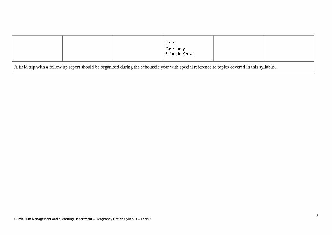
A field trip with a follow up report should be organised during the scholastic year with special reference to topics covered in this syllabus.
Curriculum Management and eLearning Department Geography Department
Geography Option
Form 3
Learning Outcomes
Curriculum Management and eLearning Department - Geography Options Syllabus Form3 - Learning Outcomes
2
Map R
ea
din
g a
nd Inte
rpre
tation
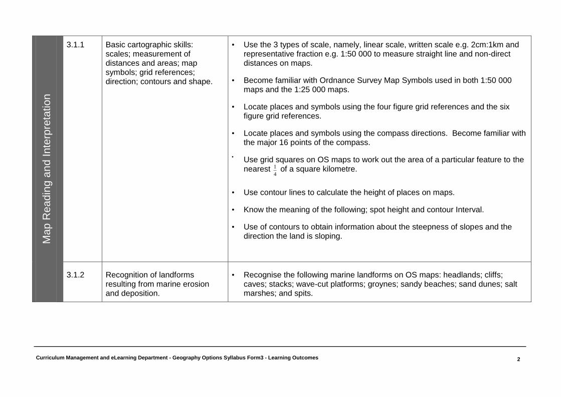
3.1.1 Basic cartographic skills:
scales; measurement of distances and areas; map symbols; grid references; direction; contours and shape.
• Use the 3 types of scale, namely, linear scale, written scale e.g. 2cm:1km and representative fraction e.g. 1:50 000 to measure straight line and non-direct distances on maps.
• Become familiar with Ordnance Survey Map Symbols used in both 1:50 000 maps and the 1:25 000 maps.
• Locate places and symbols using the four figure grid references and the six figure grid references.
• Locate places and symbols using the compass directions. Become familiar with the major 16 points of the compass.
• Use grid squares on OS maps to work out the area of a particular feature to the nearest
4
1 of a square kilometre.
• Use contour lines to calculate the height of places on maps.
• Know the meaning of the following; spot height and contour Interval.
• Use of contours to obtain information about the steepness of slopes and the direction the land is sloping.
3.1.2 Recognition of landforms resulting from marine erosion and deposition.
• Recognise the following marine landforms on OS maps: headlands; cliffs; caves; stacks; wave-cut platforms; groynes; sandy beaches; sand dunes; salt marshes; and spits.
Curriculum Management and eLearning Department - Geography Options Syllabus Form3 - Learning Outcomes
3
Weath
er
and
Clim
ate
3.2
Weath
er
and C
limate
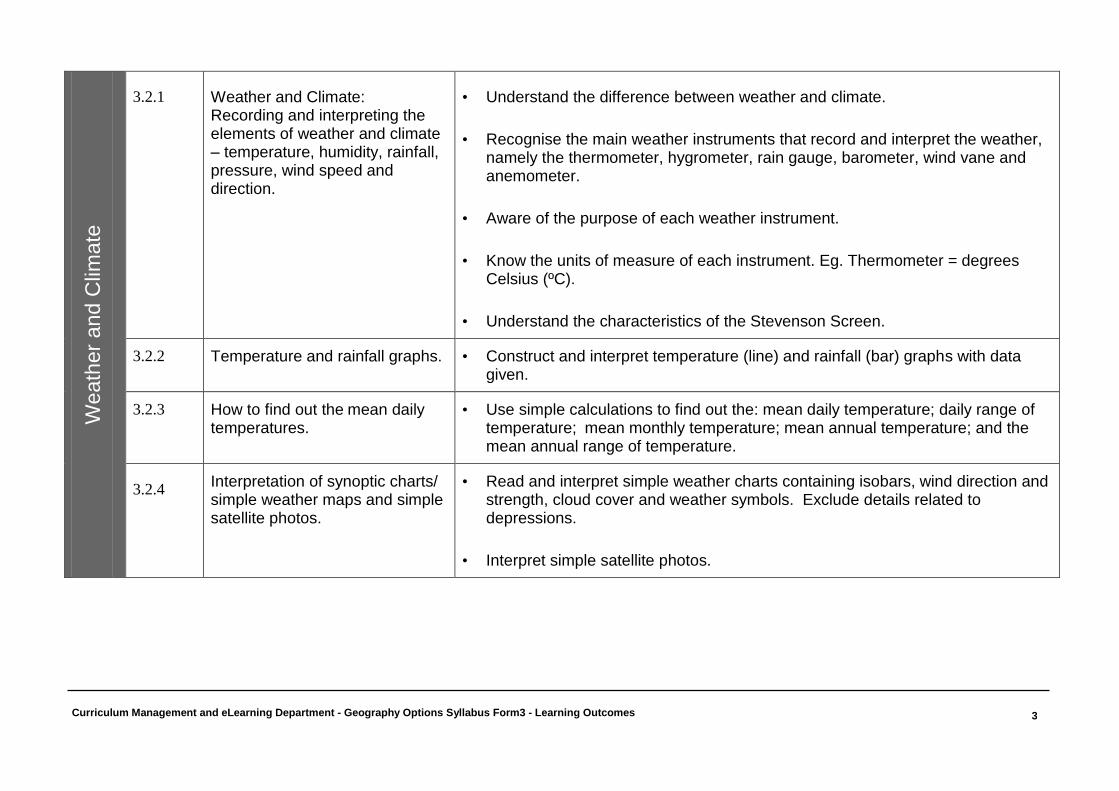
3.2.1 Weather and Climate: Recording and interpreting the elements of weather and climate – temperature, humidity, rainfall, pressure, wind speed and direction.
• Understand the difference between weather and climate.
• Recognise the main weather instruments that record and interpret the weather, namely the thermometer, hygrometer, rain gauge, barometer, wind vane and anemometer.
• Aware of the purpose of each weather instrument.
• Know the units of measure of each instrument. Eg. Thermometer = degrees Celsius (ºC).
• Understand the characteristics of the Stevenson Screen.
3.2.2 Temperature and rainfall graphs. • Construct and interpret temperature (line) and rainfall (bar) graphs with data given.
3.2.3 How to find out the mean daily temperatures.
• Use simple calculations to find out the: mean daily temperature; daily range of temperature; mean monthly temperature; mean annual temperature; and the mean annual range of temperature.
3.2.4 Interpretation of synoptic charts/ simple weather maps and simple satellite photos.
• Read and interpret simple weather charts containing isobars, wind direction and strength, cloud cover and weather symbols. Exclude details related to depressions.
• Interpret simple satellite photos.
Curriculum Management and eLearning Department - Geography Options Syllabus Form3 - Learning Outcomes
4
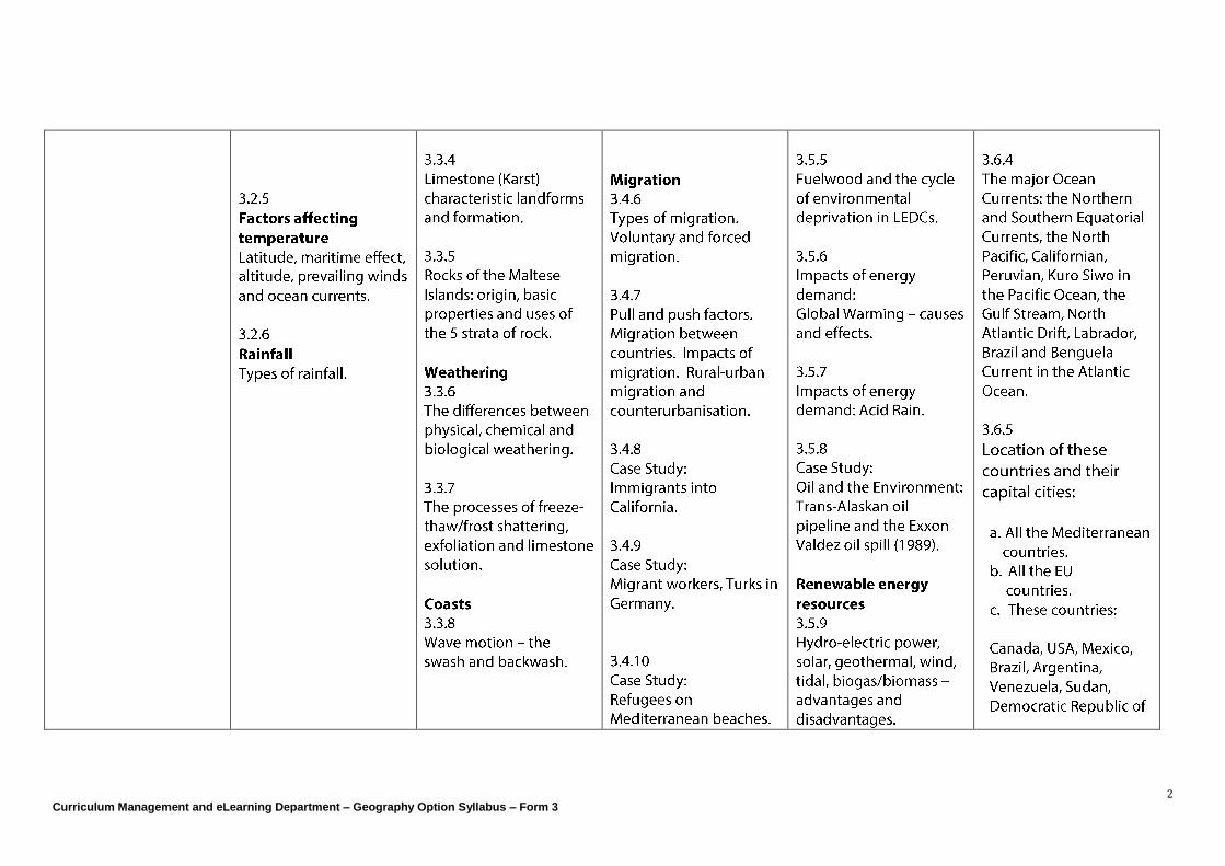
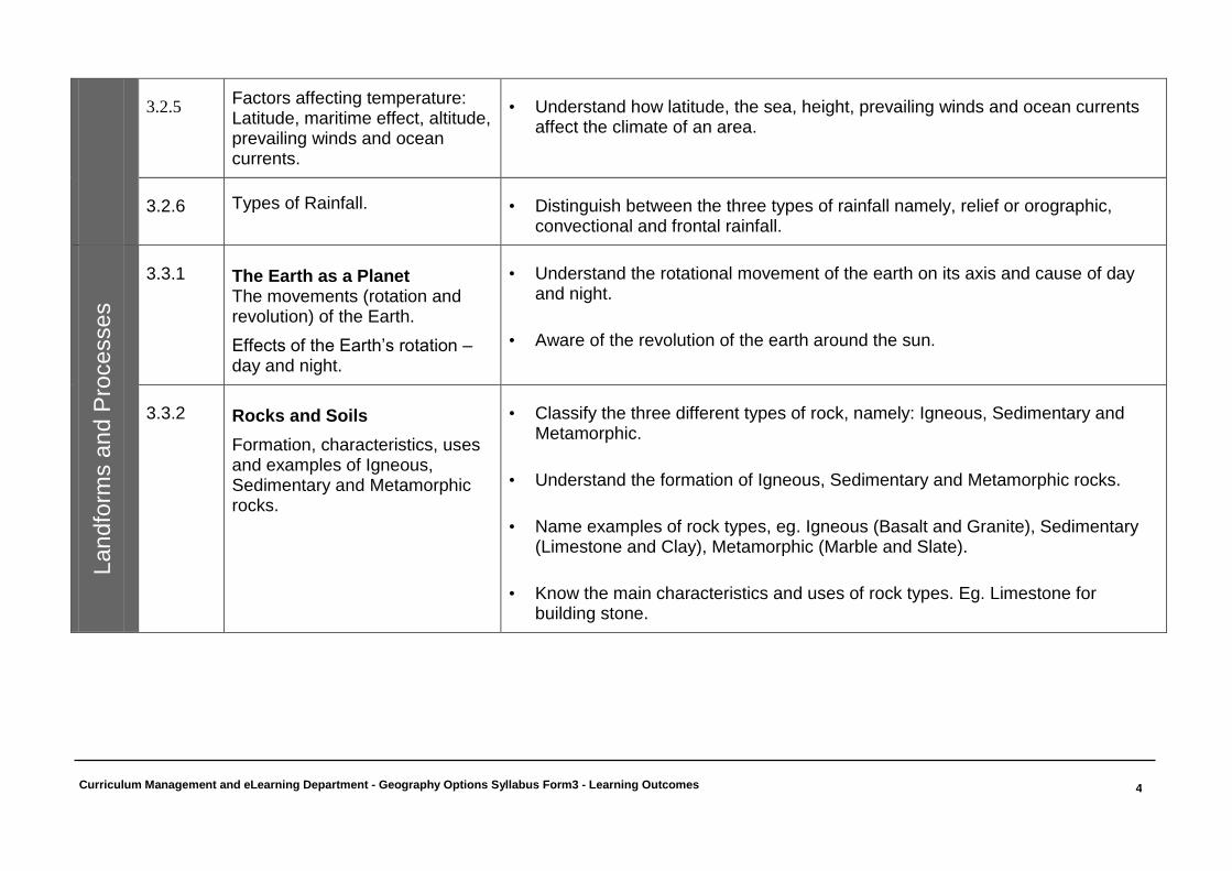
3.2.5 Factors affecting temperature: Latitude, maritime effect, altitude, prevailing winds and ocean currents.
• Understand how latitude, the sea, height, prevailing winds and ocean currents affect the climate of an area.
3.2.6 Types of Rainfall. • Distinguish between the three types of rainfall namely, relief or orographic, convectional and frontal rainfall.
Landfo
rms a
nd P
rocesses
3.3.1 The Earth as a Planet The movements (rotation and revolution) of the Earth.
Effects of the Earth’s rotation – day and night.
• Understand the rotational movement of the earth on its axis and cause of day and night.
• Aware of the revolution of the earth around the sun.
3.3.2 Rocks and Soils
Formation, characteristics, uses and examples of Igneous, Sedimentary and Metamorphic rocks.
• Classify the three different types of rock, namely: Igneous, Sedimentary and Metamorphic.
• Understand the formation of Igneous, Sedimentary and Metamorphic rocks.
• Name examples of rock types, eg. Igneous (Basalt and Granite), Sedimentary (Limestone and Clay), Metamorphic (Marble and Slate).
• Know the main characteristics and uses of rock types. Eg. Limestone for building stone.
Curriculum Management and eLearning Department - Geography Options Syllabus Form3 - Learning Outcomes
5
Landfo
rms a
nd P
rocesses
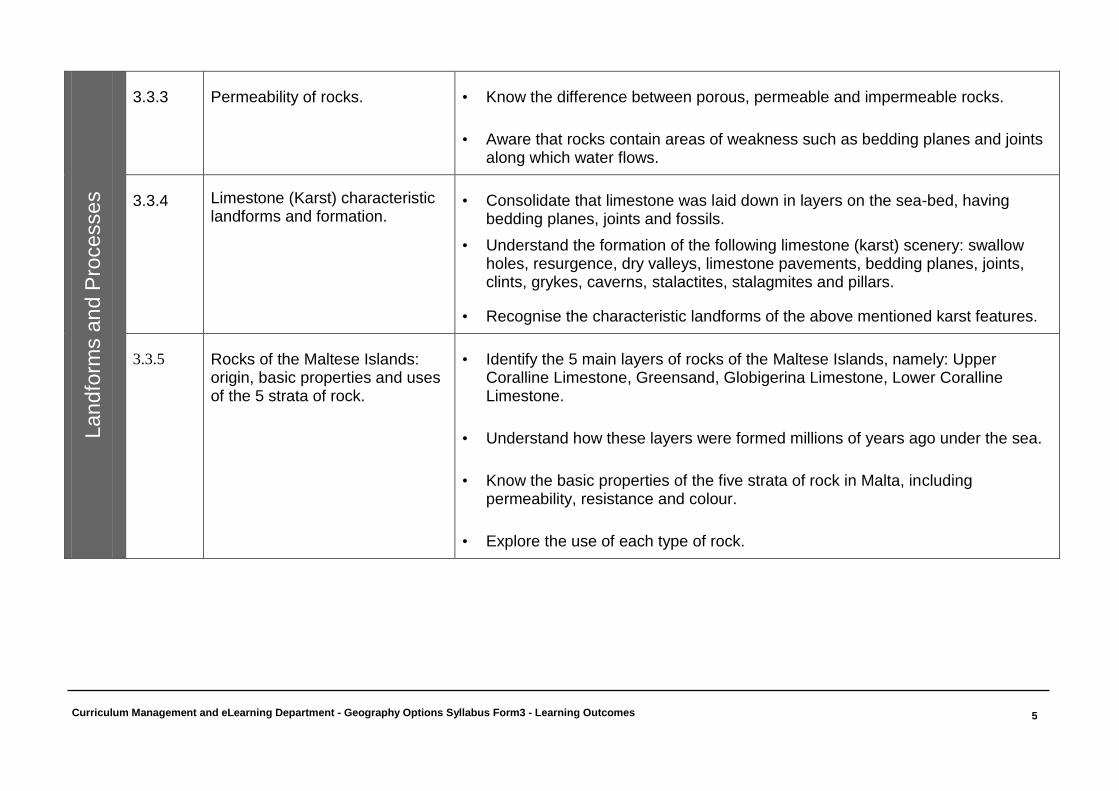
3.3.3 Permeability of rocks. • Know the difference between porous, permeable and impermeable rocks.
• Aware that rocks contain areas of weakness such as bedding planes and joints along which water flows.
3.3.4 Limestone (Karst) characteristic landforms and formation.
• Consolidate that limestone was laid down in layers on the sea-bed, having bedding planes, joints and fossils.
• Understand the formation of the following limestone (karst) scenery: swallow holes, resurgence, dry valleys, limestone pavements, bedding planes, joints, clints, grykes, caverns, stalactites, stalagmites and pillars.
• Recognise the characteristic landforms of the above mentioned karst features.
3.3.5 Rocks of the Maltese Islands: origin, basic properties and uses of the 5 strata of rock.
• Identify the 5 main layers of rocks of the Maltese Islands, namely: Upper Coralline Limestone, Greensand, Globigerina Limestone, Lower Coralline Limestone.
• Understand how these layers were formed millions of years ago under the sea.
• Know the basic properties of the five strata of rock in Malta, including permeability, resistance and colour.
• Explore the use of each type of rock.
Curriculum Management and eLearning Department - Geography Options Syllabus Form3 - Learning Outcomes
6
Landfo
rms a
nd P
rocesses
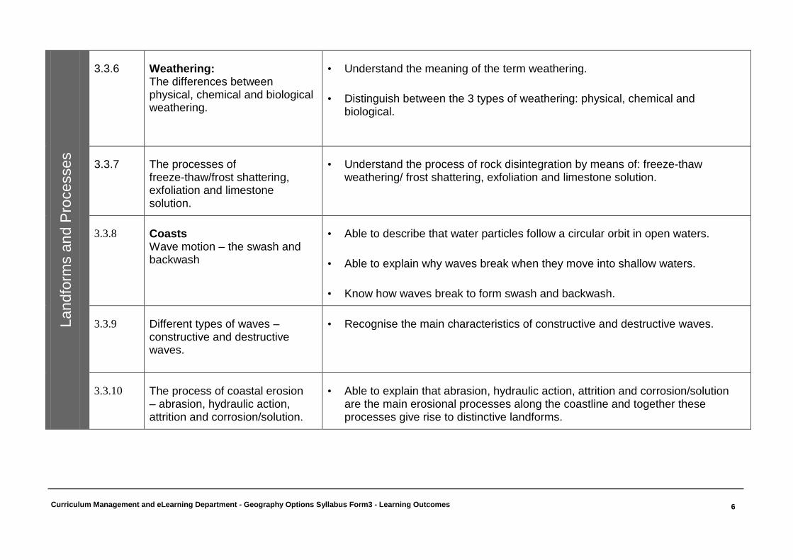
3.3.6 Weathering: The differences between physical, chemical and biological weathering.
• Understand the meaning of the term weathering.
• Distinguish between the 3 types of weathering: physical, chemical and biological.
3.3.7 The processes of freeze-thaw/frost shattering, exfoliation and limestone solution.
• Understand the process of rock disintegration by means of: freeze-thaw weathering/ frost shattering, exfoliation and limestone solution.
3.3.8 Coasts Wave motion – the swash and backwash
• Able to describe that water particles follow a circular orbit in open waters.
• Able to explain why waves break when they move into shallow waters.
• Know how waves break to form swash and backwash.
3.3.9 Different types of waves – constructive and destructive waves.
• Recognise the main characteristics of constructive and destructive waves.
3.3.10 The process of coastal erosion – abrasion, hydraulic action, attrition and corrosion/solution.
• Able to explain that abrasion, hydraulic action, attrition and corrosion/solution are the main erosional processes along the coastline and together these processes give rise to distinctive landforms.
Curriculum Management and eLearning Department - Geography Options Syllabus Form3 - Learning Outcomes
7
Landfo
rms a
nd p
rocesses
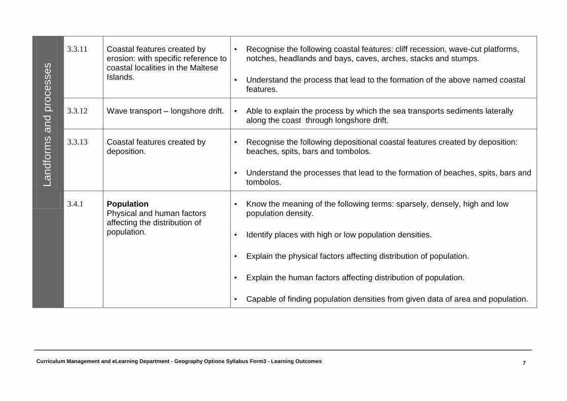
3.3.11 Coastal features created by erosion: with specific reference to coastal localities in the Maltese Islands.
• Recognise the following coastal features: cliff recession, wave-cut platforms, notches, headlands and bays, caves, arches, stacks and stumps.
• Understand the process that lead to the formation of the above named coastal features.
3.3.12 Wave transport – longshore drift. • Able to explain the process by which the sea transports sediments laterally along the coast through longshore drift.
3.3.13 Coastal features created by deposition.
• Recognise the following depositional coastal features created by deposition: beaches, spits, bars and tombolos.
• Understand the processes that lead to the formation of beaches, spits, bars and tombolos.
3.4.1 Population
Physical and human factors affecting the distribution of population.
• Know the meaning of the following terms: sparsely, densely, high and low population density.
• Identify places with high or low population densities.
• Explain the physical factors affecting distribution of population.
• Explain the human factors affecting distribution of population.
• Capable of finding population densities from given data of area and population.
Curriculum Management and eLearning Department - Geography Options Syllabus Form3 - Learning Outcomes
8
S
ocio
-Eco
no
mic
Hu
ma
n S
yste
ms
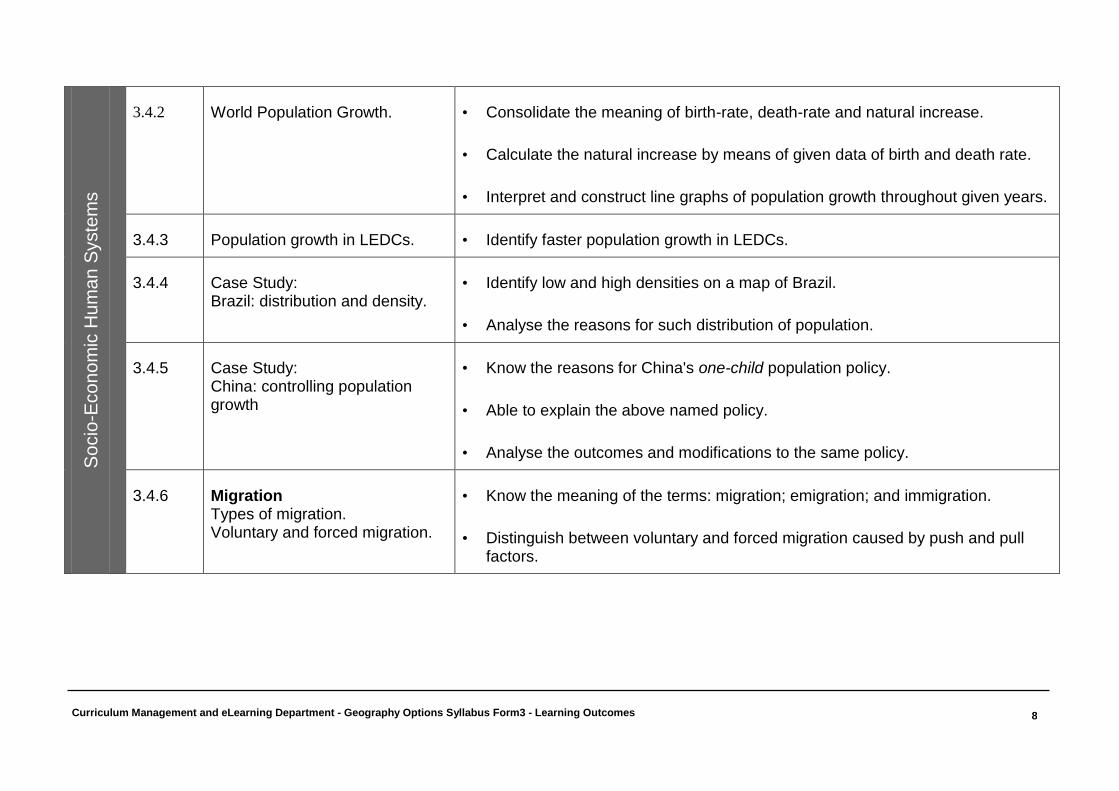
3.4.2 World Population Growth. • Consolidate the meaning of birth-rate, death-rate and natural increase.
• Calculate the natural increase by means of given data of birth and death rate.
• Interpret and construct line graphs of population growth throughout given years.
3.4.3 Population growth in LEDCs. • Identify faster population growth in LEDCs.
3.4.4 Case Study: Brazil: distribution and density.
• Identify low and high densities on a map of Brazil.
• Analyse the reasons for such distribution of population.
3.4.5 Case Study: China: controlling population growth
• Know the reasons for China's one-child population policy.
• Able to explain the above named policy.
• Analyse the outcomes and modifications to the same policy.
3.4.6 Migration Types of migration. Voluntary and forced migration.
• Know the meaning of the terms: migration; emigration; and immigration.
• Distinguish between voluntary and forced migration caused by push and pull factors.
Curriculum Management and eLearning Department - Geography Options Syllabus Form3 - Learning Outcomes
9
So
cio
-Eco
no
mic
Hu
ma
n S
yste
ms
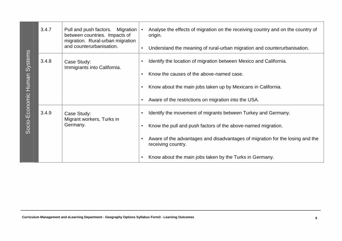
3.4.7 Pull and push factors. Migration
between countries. Impacts of migration. Rural-urban migration and counterurbanisation.
• Analyse the effects of migration on the receiving country and on the country of origin.
• Understand the meaning of rural-urban migration and counterurbanisation.
3.4.8 Case Study: Immigrants into California.
• Identify the location of migration between Mexico and California.
• Know the causes of the above-named case.
• Know about the main jobs taken up by Mexicans in California.
• Aware of the restrictions on migration into the USA.
3.4.9 Case Study: Migrant workers, Turks in Germany.
• Identify the movement of migrants between Turkey and Germany.
• Know the pull and push factors of the above-named migration.
• Aware of the advantages and disadvantages of migration for the losing and the receiving country.
• Know about the main jobs taken by the Turks in Germany.
Curriculum Management and eLearning Department - Geography Options Syllabus Form3 - Learning Outcomes
10
So
cio
-Eco
no
mic
Hu
ma
n S
yste
ms
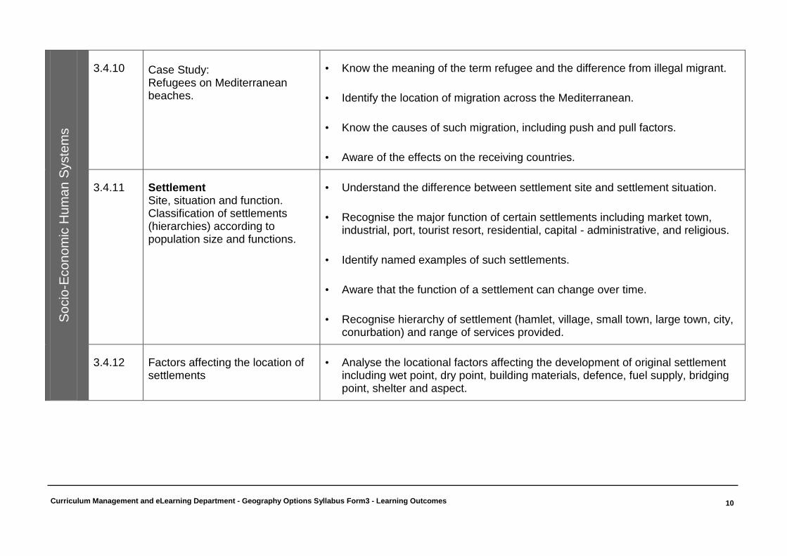
3.4.10
Case Study: Refugees on Mediterranean beaches.
• Know the meaning of the term refugee and the difference from illegal migrant.
• Identify the location of migration across the Mediterranean.
• Know the causes of such migration, including push and pull factors.
• Aware of the effects on the receiving countries.
3.4.11 Settlement Site, situation and function. Classification of settlements (hierarchies) according to population size and functions.
• Understand the difference between settlement site and settlement situation.
• Recognise the major function of certain settlements including market town, industrial, port, tourist resort, residential, capital - administrative, and religious.
• Identify named examples of such settlements.
• Aware that the function of a settlement can change over time.
• Recognise hierarchy of settlement (hamlet, village, small town, large town, city, conurbation) and range of services provided.
3.4.12 Factors affecting the location of settlements
• Analyse the locational factors affecting the development of original settlement including wet point, dry point, building materials, defence, fuel supply, bridging point, shelter and aspect.
Curriculum Management and eLearning Department - Geography Options Syllabus Form3 - Learning Outcomes
11
So
cio
-Eco
no
mic
Hu
ma
n S
yste
ms
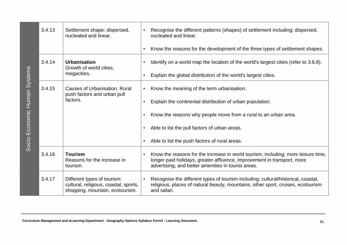
3.4.13 Settlement shape: dispersed,
nucleated and linear. • Recognise the different patterns (shapes) of settlement including; dispersed,
nucleated and linear.
• Know the reasons for the development of the three types of settlement shapes.
3.4.14 Urbanisation Growth of world cities, megacities.
• Identify on a world map the location of the world's largest cities (refer to 3.6.8).
• Explain the global distribution of the world's largest cities.
3.4.15 Causes of Urbanisation. Rural push factors and urban pull factors.
• Know the meaning of the term urbanisation.
• Explain the continental distribution of urban population.
• Know the reasons why people move from a rural to an urban area.
• Able to list the pull factors of urban areas.
• Able to list the push factors of rural areas.
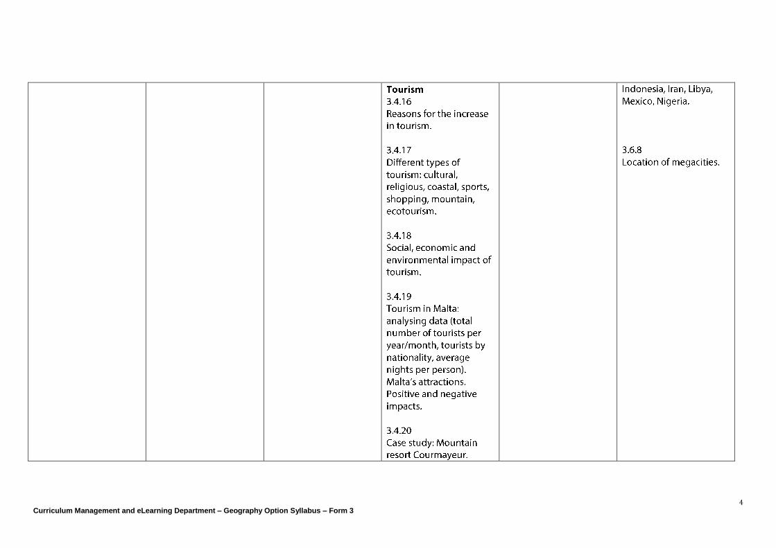
3.4.16 Tourism Reasons for the increase in tourism.
• Know the reasons for the increase in world tourism, including; more leisure time, longer paid holidays, greater affluence, improvement in transport, more advertising, and better amenities in tourist areas.
3.4.17 Different types of tourism: cultural, religious, coastal, sports, shopping, mountain, ecotourism.
• Recognise the different types of tourism including; cultural/historical, coastal, religious, places of natural beauty, mountains, other sport, cruises, ecotourism and safari.
Curriculum Management and eLearning Department - Geography Options Syllabus Form3 - Learning Outcomes
12
So
cio
-Eco
no
mic
Hu
ma
n S
yste
ms
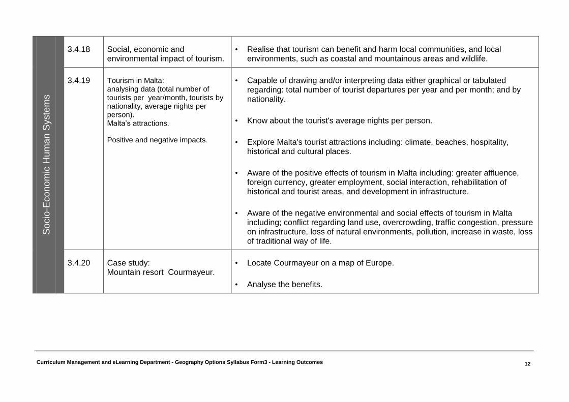
3.4.18 Social, economic and
environmental impact of tourism. • Realise that tourism can benefit and harm local communities, and local
environments, such as coastal and mountainous areas and wildlife.
3.4.19 Tourism in Malta: analysing data (total number of tourists per year/month, tourists by nationality, average nights per person). Malta’s attractions.
Positive and negative impacts.
• Capable of drawing and/or interpreting data either graphical or tabulated regarding: total number of tourist departures per year and per month; and by nationality.
• Know about the tourist's average nights per person.
• Explore Malta's tourist attractions including: climate, beaches, hospitality, historical and cultural places.
• Aware of the positive effects of tourism in Malta including: greater affluence, foreign currency, greater employment, social interaction, rehabilitation of historical and tourist areas, and development in infrastructure.
• Aware of the negative environmental and social effects of tourism in Malta including; conflict regarding land use, overcrowding, traffic congestion, pressure on infrastructure, loss of natural environments, pollution, increase in waste, loss of traditional way of life.
3.4.20 Case study: Mountain resort Courmayeur.
• Locate Courmayeur on a map of Europe.
• Analyse the benefits.
Curriculum Management and eLearning Department - Geography Options Syllabus Form3 - Learning Outcomes
13
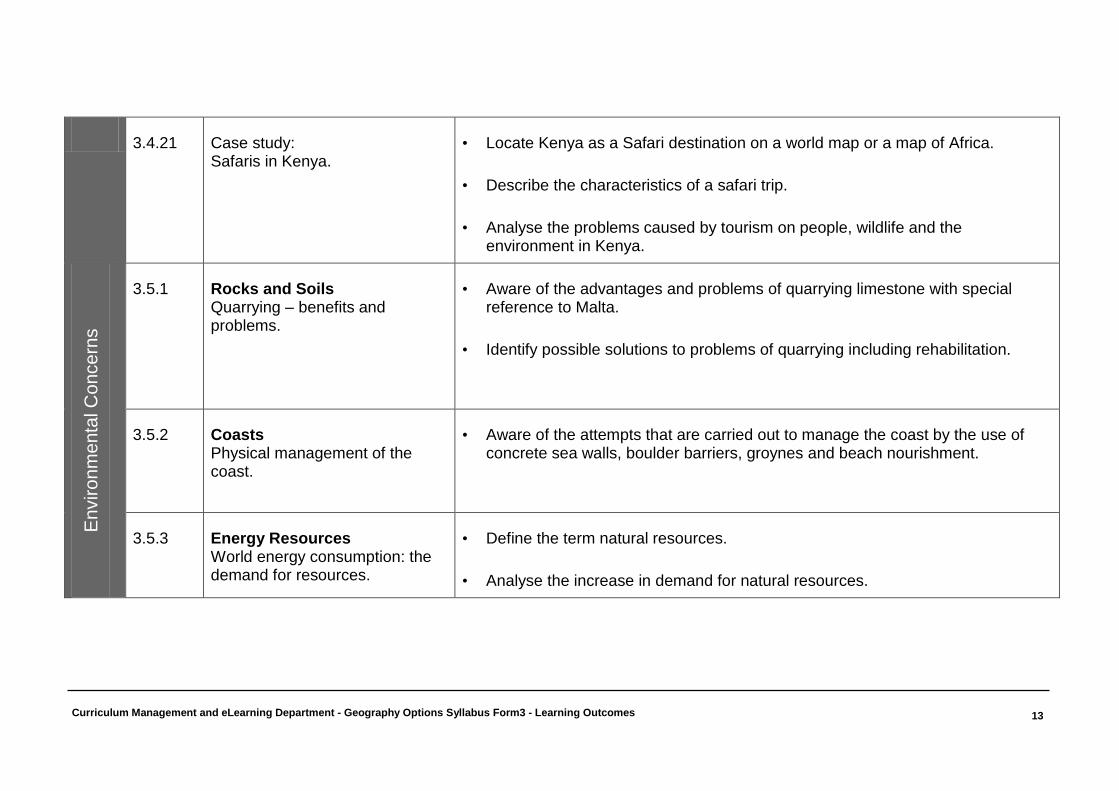
3.4.21 Case study:
Safaris in Kenya. • Locate Kenya as a Safari destination on a world map or a map of Africa.
• Describe the characteristics of a safari trip.
• Analyse the problems caused by tourism on people, wildlife and the environment in Kenya.
En
viro
nm
enta
l C
once
rns
3.5.1 Rocks and Soils Quarrying – benefits and problems.
• Aware of the advantages and problems of quarrying limestone with special reference to Malta.
• Identify possible solutions to problems of quarrying including rehabilitation.
3.5.2 Coasts Physical management of the coast.
• Aware of the attempts that are carried out to manage the coast by the use of concrete sea walls, boulder barriers, groynes and beach nourishment.
3.5.3 Energy Resources World energy consumption: the demand for resources.
• Define the term natural resources.
• Analyse the increase in demand for natural resources.
Curriculum Management and eLearning Department - Geography Options Syllabus Form3 - Learning Outcomes
14
En
viro
nm
enta
l C
once
rns
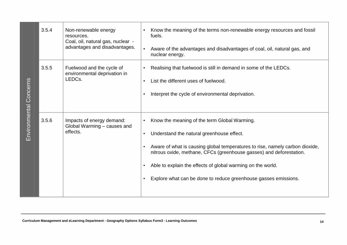
3.5.4 Non-renewable energy resources. Coal, oil, natural gas, nuclear - advantages and disadvantages.
• Know the meaning of the terms non-renewable energy resources and fossil fuels.
• Aware of the advantages and disadvantages of coal, oil, natural gas, and nuclear energy.
3.5.5 Fuelwood and the cycle of environmental deprivation in LEDCs.
• Realising that fuelwood is still in demand in some of the LEDCs.
• List the different uses of fuelwood.
• Interpret the cycle of environmental deprivation.
3.5.6 Impacts of energy demand: Global Warming – causes and effects.
• Know the meaning of the term Global Warming.
• Understand the natural greenhouse effect.
• Aware of what is causing global temperatures to rise, namely carbon dioxide, nitrous oxide, methane, CFCs (greenhouse gasses) and deforestation.
• Able to explain the effects of global warming on the world.
• Explore what can be done to reduce greenhouse gasses emissions.
Curriculum Management and eLearning Department - Geography Options Syllabus Form3 - Learning Outcomes
15
En
viro
nm
enta
l C
once
rns
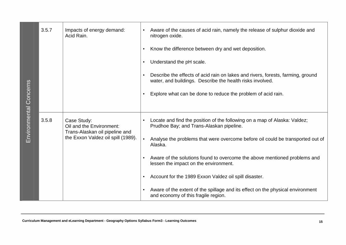
3.5.7 Impacts of energy demand: Acid Rain.
• Aware of the causes of acid rain, namely the release of sulphur dioxide and nitrogen oxide.
• Know the difference between dry and wet deposition.
• Understand the pH scale.
• Describe the effects of acid rain on lakes and rivers, forests, farming, ground water, and buildings. Describe the health risks involved.
• Explore what can be done to reduce the problem of acid rain.
3.5.8
Case Study: Oil and the Environment: Trans-Alaskan oil pipeline and the Exxon Valdez oil spill (1989).
• Locate and find the position of the following on a map of Alaska: Valdez; Prudhoe Bay; and Trans-Alaskan pipeline.
• Analyse the problems that were overcome before oil could be transported out of Alaska.
• Aware of the solutions found to overcome the above mentioned problems and lessen the impact on the environment.
• Account for the 1989 Exxon Valdez oil spill disaster.
• Aware of the extent of the spillage and its effect on the physical environment and economy of this fragile region.
Curriculum Management and eLearning Department - Geography Options Syllabus Form3 - Learning Outcomes
16
En
viro
nm
enta
l C
once
rns
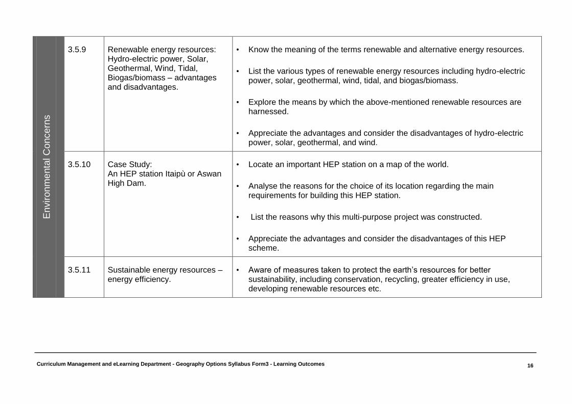
3.5.9 Renewable energy resources: Hydro-electric power, Solar, Geothermal, Wind, Tidal, Biogas/biomass – advantages and disadvantages.
• Know the meaning of the terms renewable and alternative energy resources.
• List the various types of renewable energy resources including hydro-electric power, solar, geothermal, wind, tidal, and biogas/biomass.
• Explore the means by which the above-mentioned renewable resources are harnessed.
• Appreciate the advantages and consider the disadvantages of hydro-electric power, solar, geothermal, and wind.
3.5.10 Case Study: An HEP station Itaipù or Aswan High Dam.
• Locate an important HEP station on a map of the world.
• Analyse the reasons for the choice of its location regarding the main requirements for building this HEP station.
• List the reasons why this multi-purpose project was constructed.
• Appreciate the advantages and consider the disadvantages of this HEP scheme.
3.5.11 Sustainable energy resources – energy efficiency.
• Aware of measures taken to protect the earth’s resources for better sustainability, including conservation, recycling, greater efficiency in use, developing renewable resources etc.
Curriculum Management and eLearning Department - Geography Options Syllabus Form3 - Learning Outcomes
17
Lo
catio
n a
nd
Pla
ces
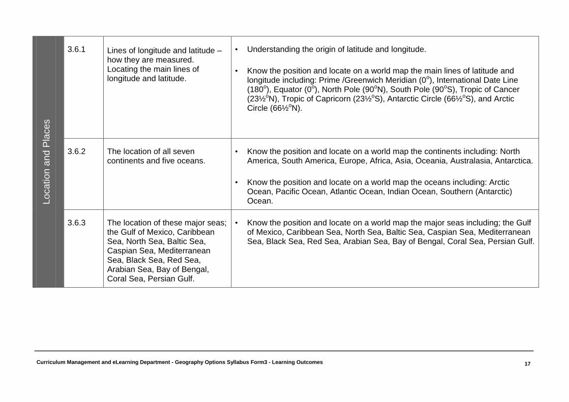
3.6.1 Lines of longitude and latitude – how they are measured. Locating the main lines of longitude and latitude.
• Understanding the origin of latitude and longitude.
• Know the position and locate on a world map the main lines of latitude and longitude including: Prime /Greenwich Meridian (0o), International Date Line (180o), Equator (0o), North Pole (90oN), South Pole (90oS), Tropic of Cancer (23½oN), Tropic of Capricorn (23½oS), Antarctic Circle (66½oS), and Arctic Circle (66½oN).
3.6.2 The location of all seven continents and five oceans.
• Know the position and locate on a world map the continents including: North America, South America, Europe, Africa, Asia, Oceania, Australasia, Antarctica.
• Know the position and locate on a world map the oceans including: Arctic Ocean, Pacific Ocean, Atlantic Ocean, Indian Ocean, Southern (Antarctic) Ocean.
3.6.3 The location of these major seas; the Gulf of Mexico, Caribbean Sea, North Sea, Baltic Sea, Caspian Sea, Mediterranean Sea, Black Sea, Red Sea, Arabian Sea, Bay of Bengal, Coral Sea, Persian Gulf.
• Know the position and locate on a world map the major seas including; the Gulf of Mexico, Caribbean Sea, North Sea, Baltic Sea, Caspian Sea, Mediterranean Sea, Black Sea, Red Sea, Arabian Sea, Bay of Bengal, Coral Sea, Persian Gulf.
Curriculum Management and eLearning Department - Geography Options Syllabus Form3 - Learning Outcomes
18
Lo
catio
n a
nd
Pla
ces
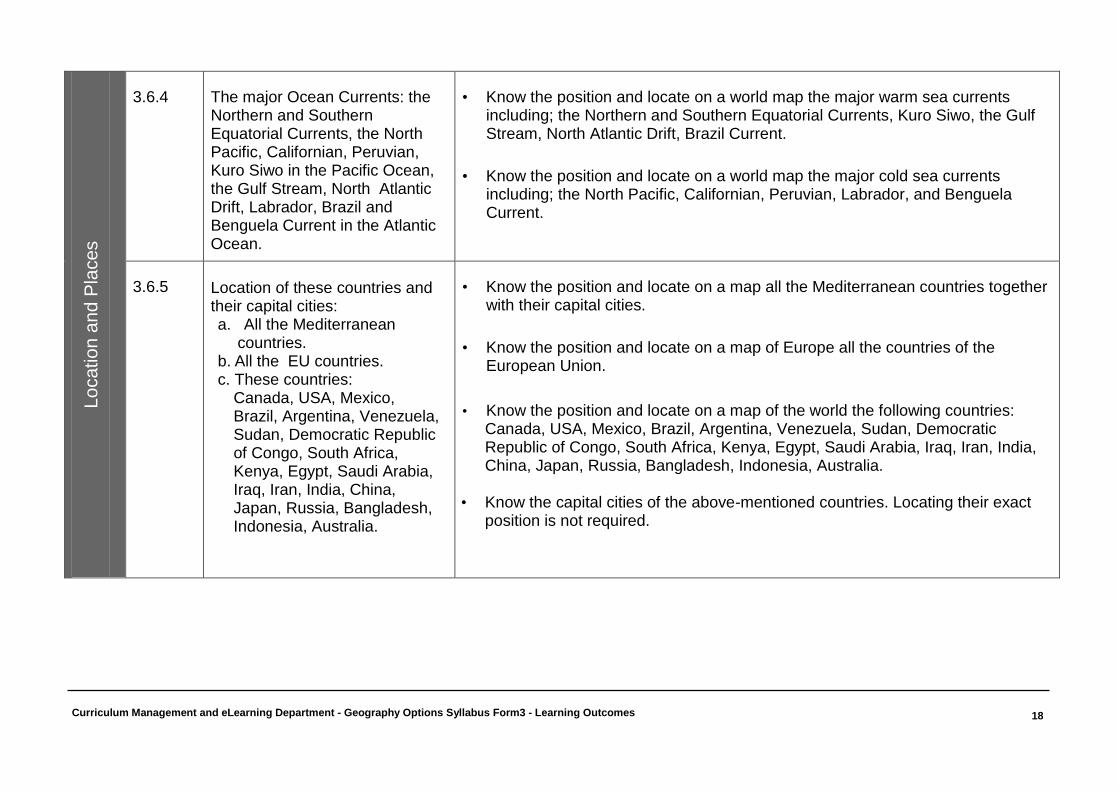
3.6.4 The major Ocean Currents: the Northern and Southern Equatorial Currents, the North Pacific, Californian, Peruvian, Kuro Siwo in the Pacific Ocean, the Gulf Stream, North Atlantic Drift, Labrador, Brazil and Benguela Current in the Atlantic Ocean.
• Know the position and locate on a world map the major warm sea currents including; the Northern and Southern Equatorial Currents, Kuro Siwo, the Gulf Stream, North Atlantic Drift, Brazil Current.
• Know the position and locate on a world map the major cold sea currents including; the North Pacific, Californian, Peruvian, Labrador, and Benguela Current.
3.6.5
Location of these countries and their capital cities: a. All the Mediterranean
countries. b. All the EU countries. c. These countries:
Canada, USA, Mexico, Brazil, Argentina, Venezuela, Sudan, Democratic Republic of Congo, South Africa, Kenya, Egypt, Saudi Arabia, Iraq, Iran, India, China, Japan, Russia, Bangladesh, Indonesia, Australia.
• Know the position and locate on a map all the Mediterranean countries together with their capital cities.
• Know the position and locate on a map of Europe all the countries of the European Union.
• Know the position and locate on a map of the world the following countries:
Canada, USA, Mexico, Brazil, Argentina, Venezuela, Sudan, Democratic Republic of Congo, South Africa, Kenya, Egypt, Saudi Arabia, Iraq, Iran, India, China, Japan, Russia, Bangladesh, Indonesia, Australia.
• Know the capital cities of the above-mentioned countries. Locating their exact
position is not required.

Curriculum Management and eLearning Department - Geography Options Syllabus Form3 - Learning Outcomes
19
Lo
catio
n a
nd
Pla
ces
3.6.6 Tourist destinations; Coastal: Spain, Caribbean. Cultural: Greece, Egypt, Malta. Ice: Alps, Rockies, Pyrenees. Pilgrimage: Mecca, Rome, Holy Land. Safari: Kenya, South Africa.
Know the position and locate on a world map important tourist destinations including: (Coastal) - Spain and the Caribbean; (Cultural) - Greece, Egypt and Malta; (Ice) - Alps, Rockies, and the Pyrenees; (Pilgrimage) Jerusalem, Mecca, Rome and (Safari) - Kenya and South Africa.
3.6.7 Energy resource rich countries: USA (Alaska), China, Russian Federation, Canada, South Africa, Saudi Arabia, Venezuela, Indonesia, Iran, Libya, Mexico, Nigeria.
• Know the position and locate on a world map the energy resource rich countries including; Alaska (USA), Canada, USA, Mexico, Venezuela, China, Russian Federation, South Africa, Saudi Arabia, Indonesia, Iran, Libya, Nigeria.
3.6.8
Location of megacities.
• Know the position and locate on a world map the following cities with a population of more than 10 million inhabitants including: New York, Los Angeles, Mexico City, São Paolo, Buenos Aires, Lagos, Tianjin, Beijing, Shanghai, Seoul, Tokyo, Osaka-Kobe, Jakarta, Mumbai, Calcutta, Karachi
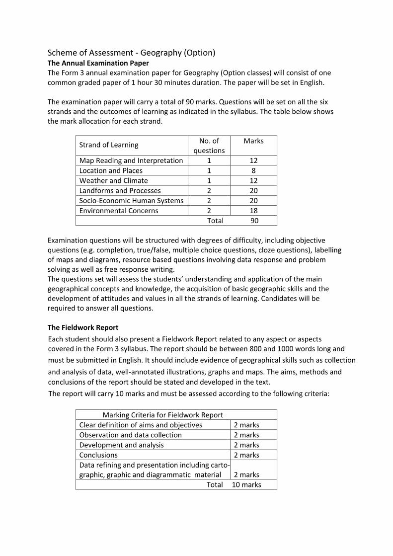
Scheme of Assessment - Geography (Option) The Annual Examination Paper The Form 3 annual examination paper for Geography (Option classes) will consist of one common graded paper of 1 hour 30 minutes duration. The paper will be set in English. The examination paper will carry a total of 90 marks. Questions will be set on all the six strands and the outcomes of learning as indicated in the syllabus. The table below shows the mark allocation for each strand.
Strand of Learning No. of questions
Marks
Map Reading and Interpretation 1 12
Location and Places 1 8
Weather and Climate 1 12
Landforms and Processes 2 20
Socio-Economic Human Systems 2 20
Environmental Concerns 2 18
Total 90
Examination questions will be structured with degrees of difficulty, including objective questions (e.g. completion, true/false, multiple choice questions, cloze questions), labelling of maps and diagrams, resource based questions involving data response and problem solving as well as free response writing. The questions set will assess the students’ understanding and application of the main geographical concepts and knowledge, the acquisition of basic geographic skills and the development of attitudes and values in all the strands of learning. Candidates will be required to answer all questions. The Fieldwork Report Each student should also present a Fieldwork Report related to any aspect or aspects covered in the Form 3 syllabus. The report should be between 800 and 1000 words long and
must be submitted in English. It should include evidence of geographical skills such as collection and analysis of data, well-annotated illustrations, graphs and maps. The aims, methods and
conclusions of the report should be stated and developed in the text.
The report will carry 10 marks and must be assessed according to the following criteria:
Marking Criteria for Fieldwork Report
Clear definition of aims and objectives 2 marks
Observation and data collection 2 marks
Development and analysis 2 marks
Conclusions 2 marks
Data refining and presentation including carto-graphic, graphic and diagrammatic material
2 marks
Total 10 marks
Geography (Option) – Form 3 Secondary – Sample Paper Page 1 of 16
DIRECTORATE FOR QUALITY AND STANDARDS IN EDUCATION
Department for Curriculum Management and eLearning
Educational Assessment Unit
Annual Examinations for Secondary Schools Specimen Paper
FORM 3 GEOGRAPHY (Option) TIME: 1h 30min
Name: _____________________________________ Class: _______________
Instructions to Candidates
Answer all questions in the space provided. Write your answers neatly and in good English. Credit
will be given for relevant illustrations. The marks for individual questions are shown in round
brackets: e.g. (4). There are 9 questions in all. The total mark for this paper is 90.
Examiner’s use only
Question No.
1 2 3 4 5 6 7 8 9 Written Exam
Fieldwork
Report
Total
Max. Mark
12 8 12 10 10 10 10 9 9 90 10 100
Score
1. Study carefully the topographical map, Map 1 on page 2.
a. What would you actually find at the following map references?
Tick () the correct answer.
458788 Tower
Sandy bay
School
Lighthouse
(1)
b. What would you actually find at the following map references?
Tick () the correct answer.
485757 Tower
Catacombs
School
Bus station
(1)
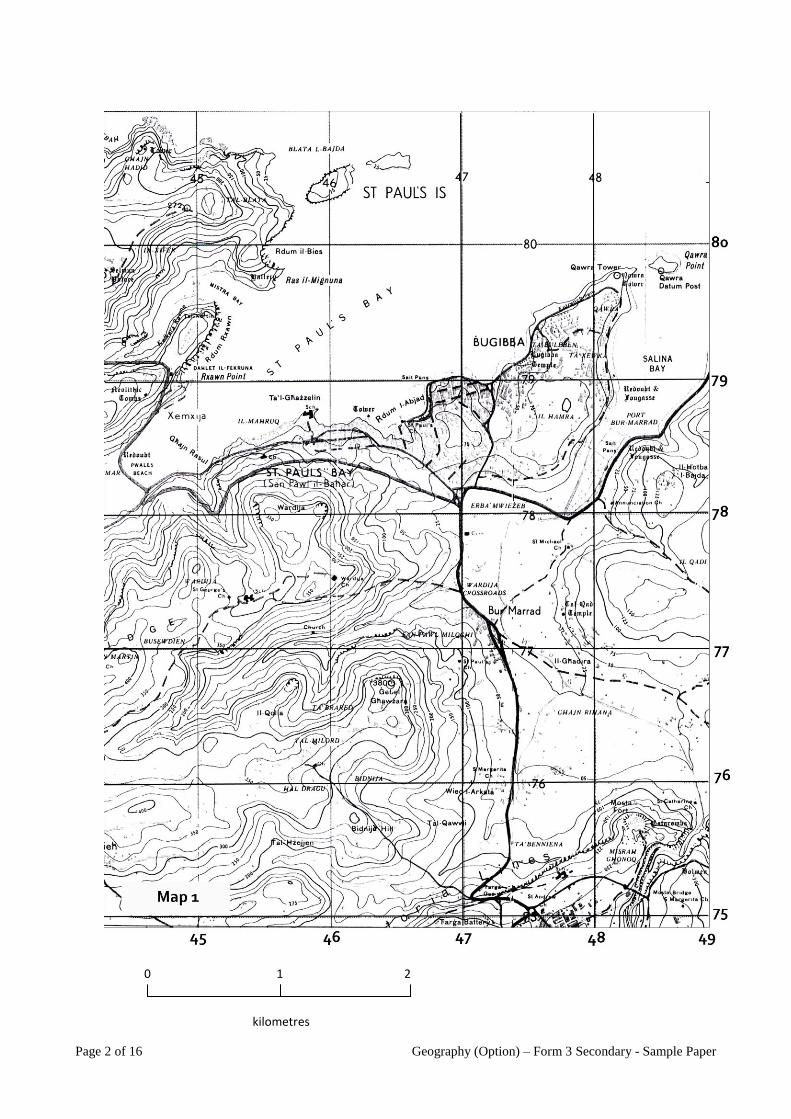
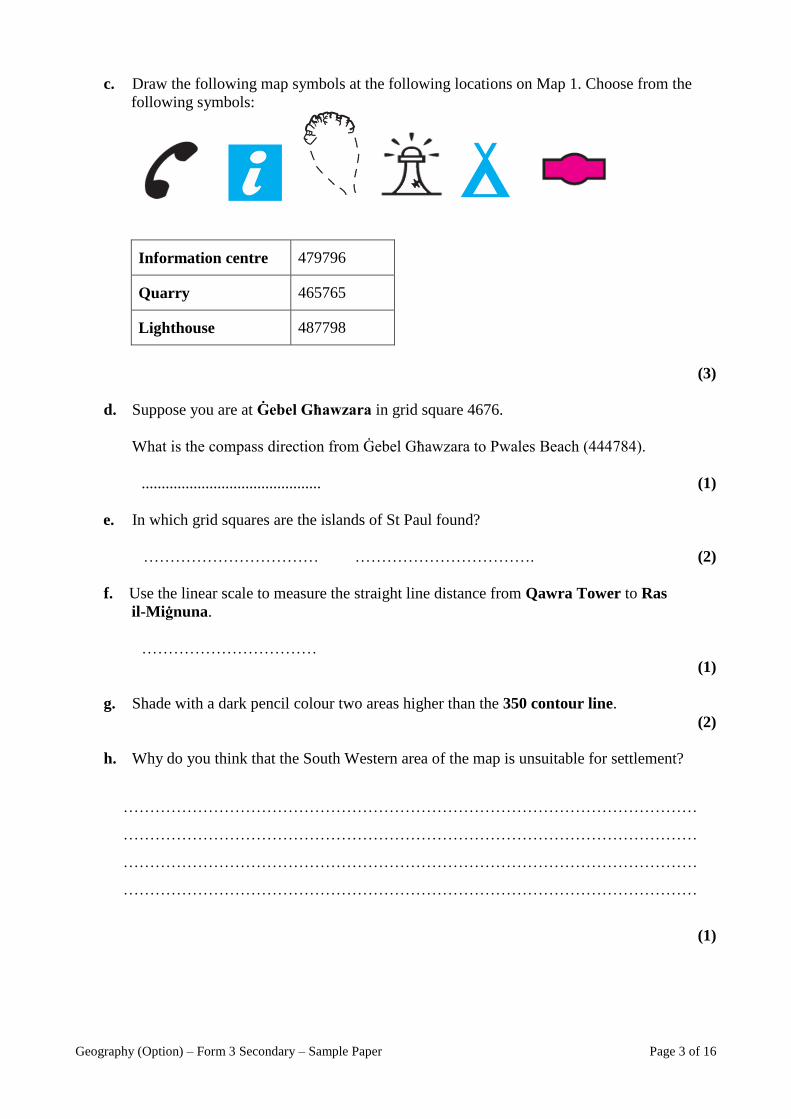
Page 2 of 16 Geography (Option) – Form 3 Secondary - Sample Paper
0 1 2
kilometres
Geography (Option) – Form 3 Secondary – Sample Paper Page 3 of 16
c. Draw the following map symbols at the following locations on Map 1. Choose from the
following symbols:
Information centre 479796
Quarry 465765
Lighthouse 487798
(3)
d. Suppose you are at Ġebel Għawzara in grid square 4676.
What is the compass direction from Ġebel Għawzara to Pwales Beach (444784).
............................................. (1)
e. In which grid squares are the islands of St Paul found?
…………………………… ……………………………. (2)
f. Use the linear scale to measure the straight line distance from Qawra Tower to Ras
il-Miġnuna.
……………………………
(1)
g. Shade with a dark pencil colour two areas higher than the 350 contour line.
(2)
h. Why do you think that the South Western area of the map is unsuitable for settlement?
(1)
………………………………………………………………………………………………
………………………………………………………………………………………………
………………………………………………………………………………………………
………………………………………………………………………………………………
Page 4 of 16 Geography (Option) – Form 3 Secondary - Sample Paper
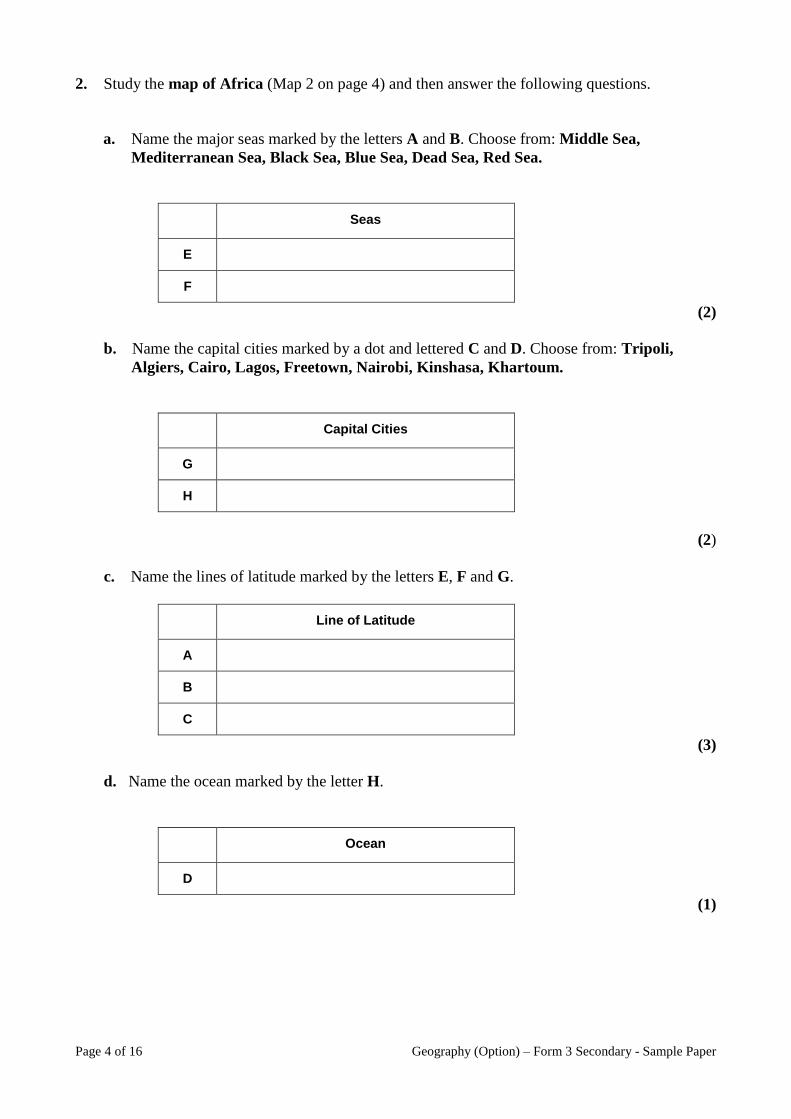
2. Study the map of Africa (Map 2 on page 4) and then answer the following questions.
a. Name the major seas marked by the letters A and B. Choose from: Middle Sea,
Mediterranean Sea, Black Sea, Blue Sea, Dead Sea, Red Sea.
Seas
E
F
(2)
b. Name the capital cities marked by a dot and lettered C and D. Choose from: Tripoli,
Algiers, Cairo, Lagos, Freetown, Nairobi, Kinshasa, Khartoum.
Capital Cities
G
H
(2)
c. Name the lines of latitude marked by the letters E, F and G.
Line of Latitude
A
B
C
(3)
d. Name the ocean marked by the letter H.
Ocean
D
(1)
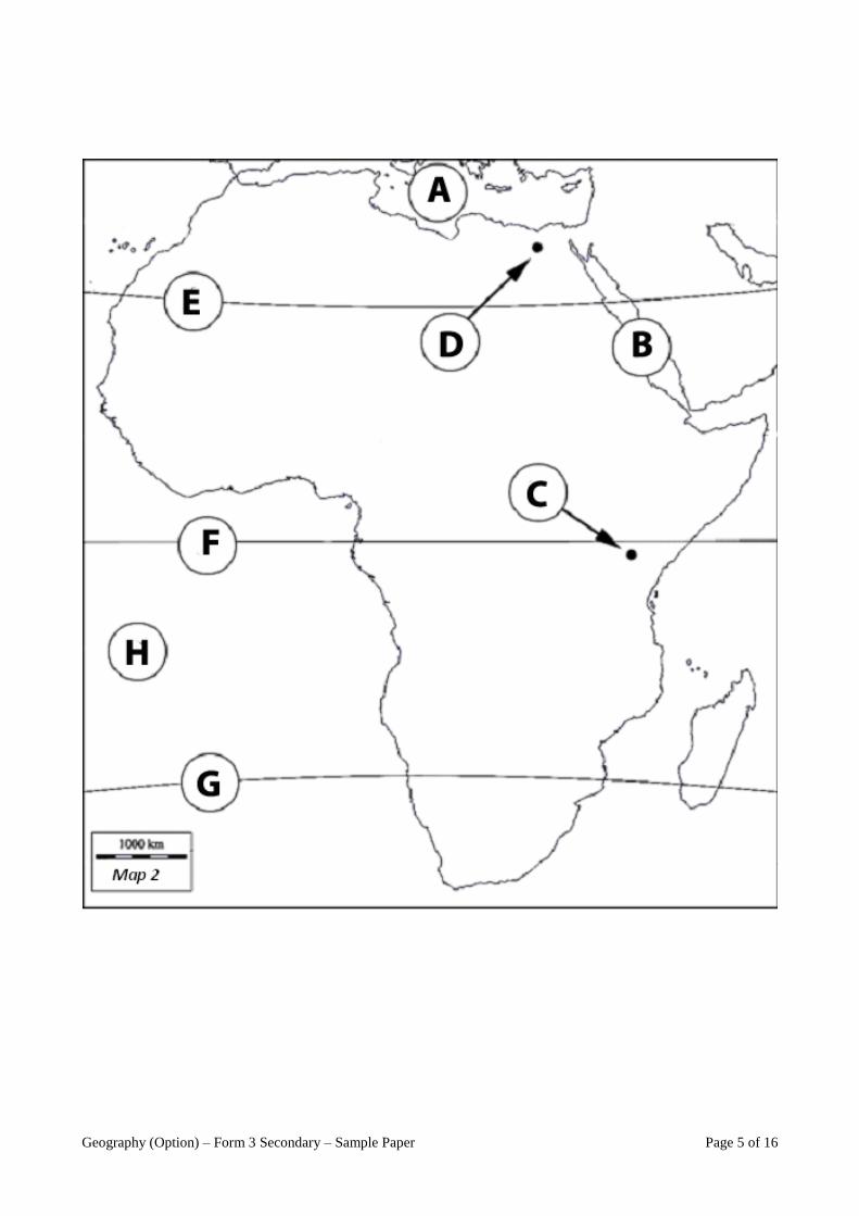
Geography (Option) – Form 3 Secondary – Sample Paper Page 5 of 16
Page 6 of 16 Geography (Option) – Form 3 Secondary - Sample Paper
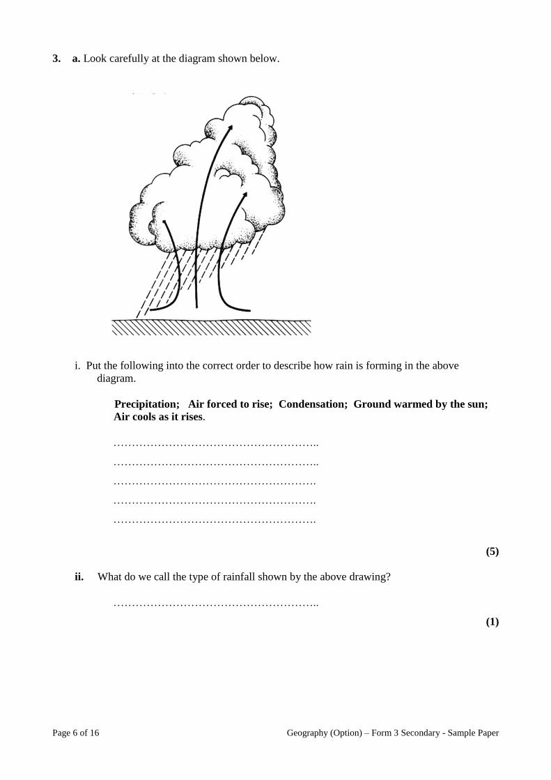
3. a. Look carefully at the diagram shown below.
i. Put the following into the correct order to describe how rain is forming in the above
diagram.
Precipitation; Air forced to rise; Condensation; Ground warmed by the sun;
Air cools as it rises.
………………………………………………..
………………………………………………..
……………………………………………….
……………………………………………….
……………………………………………….
(5)
ii. What do we call the type of rainfall shown by the above drawing?
………………………………………………..
(1)
Geography (Option) – Form 3 Secondary – Sample Paper Page 7 of 16
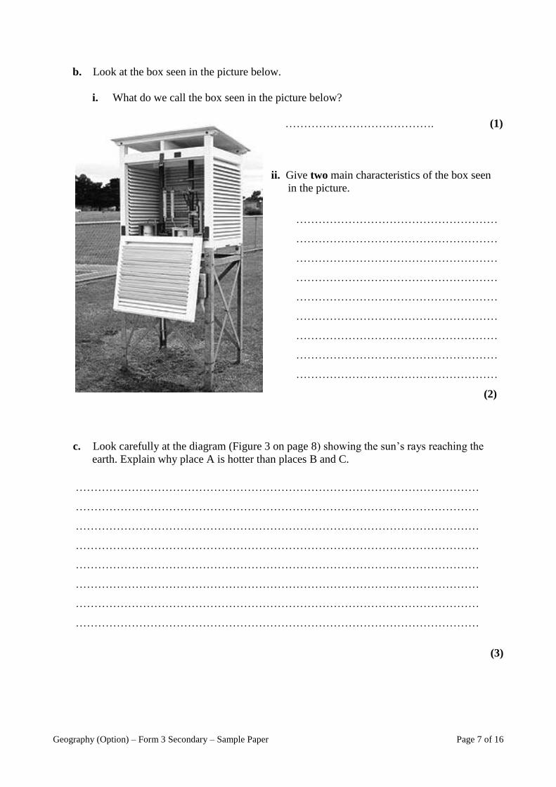
b. Look at the box seen in the picture below.
i. What do we call the box seen in the picture below?
…………………………………. (1)
ii. Give two main characteristics of the box seen
in the picture.
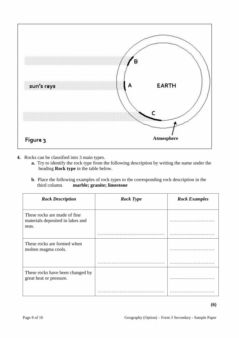
c. Look carefully at the diagram (Figure 3 on page 8) showing the sun’s rays reaching the
earth. Explain why place A is hotter than places B and C.
(3)
………………………………………………………………………………………………
………………………………………………………………………………………………
………………………………………………………………………………………………
………………………………………………………………………………………………
………………………………………………………………………………………………
………………………………………………………………………………………………
………………………………………………………………………………………………
………………………………………………………………………………………………
………………………………………………
………………………………………………
………………………………………………
………………………………………………
………………………………………………
………………………………………………
………………………………………………
………………………………………………
………………………………………………
(2)
Page 8 of 16 Geography (Option) – Form 3 Secondary - Sample Paper
4. Rocks can be classified into 3 main types.
a. Try to identify the rock type from the following description by writing the name under the
heading Rock type in the table below.
b. Place the following examples of rock types to the corresponding rock description in the
third column. marble; granite; limestone
Rock Description Rock Type Rock Examples
These rocks are made of fine
materials deposited in lakes and
seas.
……………………………………
……………………….
……………………….
These rocks are formed when
molten magma cools.
……………………………………
……………………….
……………………….
These rocks have been changed by
great heat or pressure.
……………………………………
……………………….
……………………….
(6)
Atmosphere
Geography (Option) – Form 3 Secondary – Sample Paper Page 9 of 16
c. Briefly explain the meaning of the following terms:
Bedding plane:
Joint:
Impermeable rock:
Swallow hole:
(4)
5. Look carefully at the photo seen below.
a. Name the type of weathering taking
place in the photo .
………………………………………………………………………………………………
………………………………………………………………………………………………
………………………………………………………………………………………………
………………………………………………………………………………………………
………………………………………………………………………………………………
………………………………………………………………………………………………
………………………………………………………………………………………………
………………………………………………………………………………………………
………………………………………………………………………………………………
………………………………………………………………………………………………
(1)

Page 10 of 16 Geography (Option) – Form 3 Secondary - Sample Paper
b. The diagrams below show how freeze-thaw weathering can break up rocks. Write briefly
what is happening in each diagram.
(4)
c. In the space provided below draw a well labelled diagram and explain the final step of freeze-
thaw weathering.
………………………………………………………
………………………………………………………
………………………………………………………
………………………………………………………
………………………………………………………
………………………………………………………
………………………………………………………
………………………………………………………
………………………………………………………
………………………………………………………
………………………………………………………
………………………………………………………
………………………………………………………
………………………………………………………
………………………………………………………
………………………………………………………
………………………………………………………
…………………………………………… (3)
Geography (Option) – Form 3 Secondary – Sample Paper Page 11 of 16
6. a. Define the terms:
i. Birth rate: ………………………………………………………………………………
………………………………………………………………………………………………..
ii. Death rate: ……………………………………………………………………………….
………………………………………………………………………………………………..
(4)
b. Apart from birth rates and death rates, name another aspect of population which might
affect population change in a country?
………………………………………………… (1)
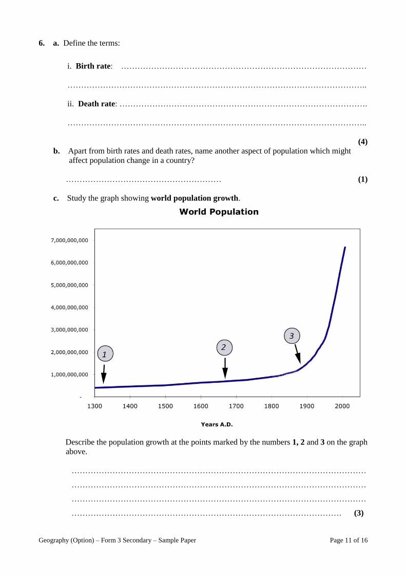
c. Study the graph showing world population growth.
Describe the population growth at the points marked by the numbers 1, 2 and 3 on the graph
above.
………………………………………………………………………………………………
………………………………………………………………………………………………
………………………………………………………………………………………………
……………………………………………………………………………………… (3)
Page 12 of 16 Geography (Option) – Form 3 Secondary - Sample Paper
c. What can be done to control population growth in less economically developed countries
(LEDCs)?
………………………………………………………………………………………………
………………………………………………………………………………………………
………………………………………………………………………………………………
……………………………………………………………………………………… (2)
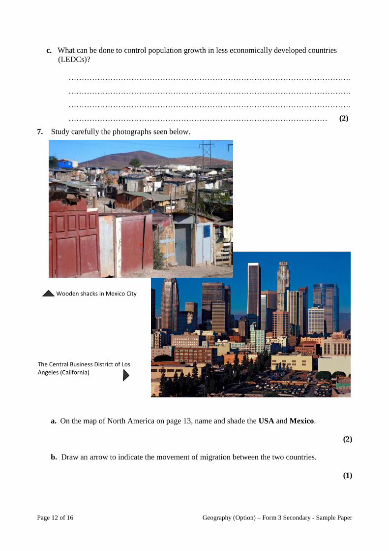
7. Study carefully the photographs seen below.
a. On the map of North America on page 13, name and shade the USA and Mexico.
(2)
b. Draw an arrow to indicate the movement of migration between the two countries.
(1)
Wooden shacks in Mexico City
The Central Business District of Los Angeles (California)
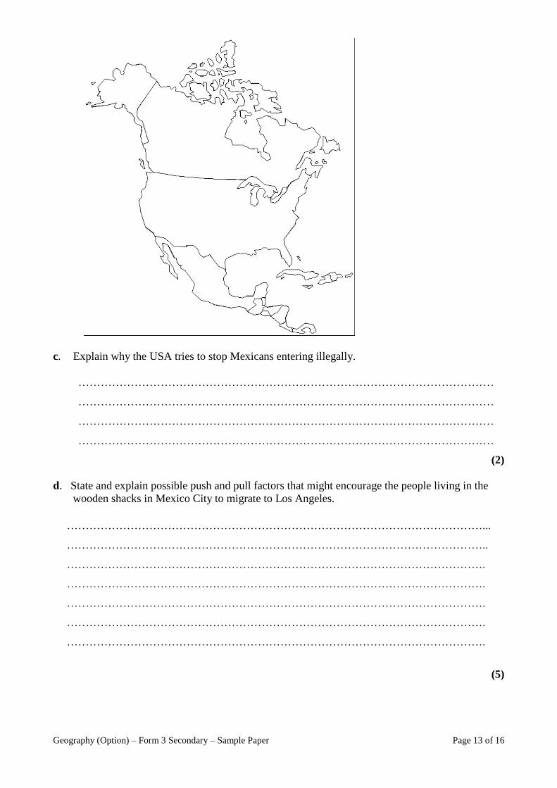
Geography (Option) – Form 3 Secondary – Sample Paper Page 13 of 16
c. Explain why the USA tries to stop Mexicans entering illegally.
…………………………………………………………………………………………………
…………………………………………………………………………………………………
…………………………………………………………………………………………………
…………………………………………………………………………………………………
(2)
d. State and explain possible push and pull factors that might encourage the people living in the
wooden shacks in Mexico City to migrate to Los Angeles.
(5)
…………………………………………………………………………………………………...
…………………………………………………………………………………………………..
………………………………………………………………………………………………….
………………………………………………………………………………………………….
………………………………………………………………………………………………….
………………………………………………………………………………………………….
………………………………………………………………………………………………….
Page 14 of 16 Geography (Option) – Form 3 Secondary - Sample Paper
8. Read carefully the following newspaper article about acid rain in China.
Third of China 'hit by acid rain' One third of China is suffering from acid rain caused by rapid industrial growth, an
official report quoted by the state media says.
Pollution levels have risen and air quality has deteriorated, the report found. This comes
despite a pledge by the authorities to clean up the air. China has some of the world's most
polluted cities and rivers. A report published recently stated that more than 25.5 million tonnes
of sulphur dioxide were spewed out, mainly from the country's coal-burning factories last year
- up 27% from 2000. Emissions of sulphur dioxide - the chemical that causes acid rain - were
double the safe level, the report said. In some areas, rainfall was 100% acid rain, it added.
Increased sulphur dioxide emissions meant that one-third of China's territory was affected by
acid rain, posing a major threat to soil and food safety.
a. According to the report, what chemical is causing acid rain in most Chinese cities?
……………………………………………….. (1)
b. What is the main source of this chemical in China?
………………………………………………………………………………………………
(1)
c. Name another chemical not mentioned in the report that can also cause acid rain.
……………………………………………… (1)
d. What are the likely effects of acid rain in China?
………………………………………………………………………………………………
………………………………………………………………………………………………
………………………………………………………………………………………………
………………………………………………………………………………………………
………………………………………………………………………………………………
………………………………………………………………………………………………
………………………………………………………………………………………………
(3)
Geography (Option) – Form 3 Secondary – Sample Paper Page 15 of 16
e. What can be done by the Chinese government to reduce the effects of acid rain?
………………………………………………………………………………………………
………………………………………………………………………………………………
………………………………………………………………………………………………
………………………………………………………………………………………………
………………………………………………………………………………………………
………………………………………………………………………………………………
………………………………………………………………………………………………
(3)
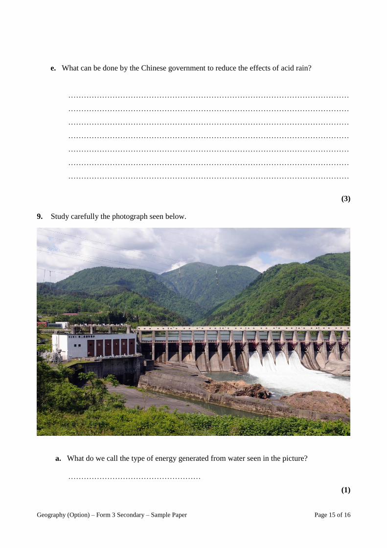
9. Study carefully the photograph seen below.
a. What do we call the type of energy generated from water seen in the picture?
……………………………………………
(1)
Page 16 of 16 Geography (Option) – Form 3 Secondary - Sample Paper
b. Briefly explain how such energy is produced.
………………………………………………………………………………………………
………………………………………………………………………………………………
………………………………………………………………………………………………
………………………………………………………………………………………………
(2)
c. Explain two advantages and two disadvantages of this source of energy.
………………………………………………………………………………………………
………………………………………………………………………………………………
………………………………………………………………………………………………
………………………………………………………………………………………………
(4)
d. Name another renewable source of energy that uses water to generate electricity.
………………………………………………
(2)