Embed Size (px)
Citation preview

Geography Scheme of Work
St. Mary’s Church of England Primary School, High Crompton
Geography Scheme of Work

Geography Scheme of Work
EYFS - Autumn Programme of Study
Knowledge, Skills and Understanding
Activity/ Link to scheme of work
All aboard Knowledge and Understanding of the World People and Communities:
• We will talk about past and present events in their own lives and know how they are similar and different to others.
People and Communities:
• Enjoys joining in with family customs and routines.
• Children talk about the past and present events in their own lives and in the lives of family members.
• They know that other children don’t always enjoy the same things, and are sensitive to this.
• They know about similarities and differences between themselves and others, and among families and communities.
See PHSE activities Talk about my house and who lives there. Can I say my address
Is there anybody out there? Knowledge and Understanding of the World
People and Communities:
• Know that people have
differences and there are differences between themselves and others traditions
People and Communities:
• They know that other children don’t always enjoy the same things, and are sensitive to this.
• They know about similarities and differences between themselves and others, and traditions
See PHSE activities Diwali activities – role-play stories, rangoli patterns life in India and celebrations Talk about differences between own and other’s cultures, family traditions and celebrations. Can I name and describe the planet that I live on? Can I talk about space? Diwali

Geography Scheme of Work
EYFS - Spring Programme of Study
Knowledge, Skills and Understanding
Activity/ Link to scheme of work
Once upon a time Knowledge and Understanding of the World People and Communities:
• We will look at similarities and differences between ourselves and other traditions and be sensitive to these traditions. (Chinese New Year)
The World: • We will look at similarities
and differences in objects and materials. (Main Focus)
People and communities
• They know that other children don’t always enjoy the same things and are sensitive to this.
• They know about similarities and differences between themselves and others and among traditions.
The world
• Children know about similarities and differences in objects and materials.
See PHSE activities Chinese New Year – life in China and celebrations Pancake day Name and compare different houses and building materials. Name, compare and sort different materials.
Who’s afraid of the big bad scarecrow Knowledge and Understanding of the World
The World:
• We will look at similarities and differences in living things. We will make observations of plants and say why things change and may happen. (Main Focus)
The world
• Children know about similarities and differences in relation to living things.
• Children make observations of animals and plants and explain why some thing occur, and talk about changes..
See PHSE activities Different environments needed for Plant and seeds to grow. Celery experiment. Talk about and sequence plant life cycle (including decay)

Geography Scheme of Work
EYFS –Summer Programme of Study
Knowledge, Skills and Understanding
Activity/ Link to scheme of work
Who goes to the ugly bug ball? Knowledge and Understanding of the World The World:
• Learn about location of animals and how features of animals relates to their environment.
The world
• Know about similarities and differences in relation to living things.
• Make observations of animals and explain why some things occur, and talk about changes.
See PHSE activities Identify, name and talk about mini-beasts in the local environment. Make a happy home for a bug.
Where shall we go today? Knowledge and Understanding of the World
People and Communities:
• We will talk about seasides in the past and know about similarities and differences between communities.
The World:
• We will talk about similarities and differences in relation to places and features of their own immediate environment
People and communities
• Children talk about the past and present events in their own lives and in the lives of family members. (E.g. seasides in the past)
• They know about similarities and differences between communities.
The world
• Children know about similarities and differences in relation to places.
• They talk about the features of their own immediate environment and how environments may vary from one another.
See PHSE activities Explore animals from around the world. Compare environments and animals in cold places (penguins) and hot places (Africa). Find out about holidays in the past - video

Geography Scheme of Work
Year 1 – Autumn: Local Area Pupils should develop knowledge about their locality. They should understand basic subject-specific vocabulary relating to human and physical geography and begin to use geographical skills, including first-hand observation, to enhance their locational awareness. Key human features, including: city, town, village, factory, farm, house, office, and shop Use simple fieldwork and observational skills to study the geography of their school and its grounds and the key human and physical features of its surrounding environment. Devise a simple map Use world maps, atlases and globes to identify the United Kingdom and its countries, Programme of Study
Knowledge, Skills and Understanding
Activity/ Link to scheme of work
Geographical Enquiry Fieldwork
• Can they say what they like/dislike about their locality? • Can they sort things they like and don’t like? • Can they answer some questions using different
resources, such as books, the internet and atlases? • Can they make a map of our classroom using bird’s eye
view? • Can they make a picture map of the local area • Can they use a plan to describe our local area • Can they plan a journey within our school site? • Can they think of a few relevant questions to ask about
a locality?
Fieldwork around High Crompton and St. Mary’s School Locate UK on globe, world map and in atlas. Name the UK countries on a map. Atlas activities. Group work- follow routes around school and describe. Look at and discuss local area plan in groups. Draw a plan of the classroom. Videos and activities: Espresso> Geography 1> Our Journey to school- Sophie and Sal Espresso> Geography 1> Around our school- Sophie and Sal
Physical Geography • Can they describe some physical features of their own
locality and using Geographical vocabulary? • Can they describe some places which are not near the
school?
Describe holiday locations- linked to postcard task. Describe own house and surrounding area.
Human Geography • Can they tell someone their address and what it is like
to live there? • Can they name key features associated with a town or
Write own address. Describe immediate area- what can I see through the window?

Geography Scheme of Work
village, e.g. ‘church’, ‘farm’, ‘shop’, ‘house’? • Can they describe a locality using geographical words
and pictures? (See Vocab listed above and opposite) • Can they talk about ways to improve the locality? • Can they describe the key features of a place, using
words like, factory, farm, house, office, shop • Can they describe what they like/dislike about our local
area and why?
city, town, village, factory, farm, house, office, and shop- label on plan Look at photos and Local Area Walk- how to improve area. Group work- likes/dislikes and present to class.
Geographical Knowledge
• Can they find where they live on a map of the UK? • Can they use simple compass directions: N, S, E, W • Can they use locational and directional language for
example near and far, left and right?
Map work. Hall – practical games Area Walk discussion. http://digimapforschools.edina.ac.uk/

Geography Scheme of Work
Year 1 – Spring: Weather Identify seasonal and daily weather patterns in the United Kingdom The location of hot and cold areas of the world in relation to the Equator and the North and South Poles Use basic geographical vocabulary to refer to:
• key physical features, including: season and weather Programme of Study
Knowledge, Skills and Understanding
Activity/ Link to scheme of work
Geographical Enquiry
• Can they think of a few relevant questions to ask about a weather map?
• Can they use weather symbols on a map?
Group work- questions for variety of weather maps. Match symbol with description. Videos and activities: Espresso> Geography 1> Whatever the Weather
Physical Geography
• Can they answer questions about the weather? • Can they keep a weather chart? • Can they collect weather information over a longer
period and use it to answer questions? • Can they explain the main features of a hot and
cold place and how they are different?
Answer questions for different maps. Keep weather chart over the term- identify how changes over time-season. Collect rainfall, wind speed, temperature. Look at physical features and weather of localities- desert, rainforest, poles. Specify Hot and Cold places Videos and activities: Espresso> Geography 1> Whatever the Weather
Human Geography
• Can they begin to explain why they would wear different clothes at different times of the year?
• Can they tell something about the people who live in hot and cold places?
• Can they explain what they might wear if they lived in a very hot or a very cold place?
• Can they explain how the weather affects different people?
Group work- questions for variety of weather maps. Match symbol with description. Link to science- characteristics of materials- eg cotton cool, wool warm. Internet research- Eskimos, African tribes. Look at dress of above groups. Problems and how cope with conditions –as above.
Geographical Knowledge
• Can they identify the four countries making up the United Kingdom and their capital cities?
• Can they name and locate the surrounding seas? • Can they point out where the equator, north pole
and South Pole are on a globe or atlas?
Link UK countries and seas for creating weather Maps of the UK or presenting the weather. Look into visit to Media City – Salford? Find Equator, North Pole and South Pole on globe and map. Espresso activities. http://digimapforschools.edina.ac.uk/
Geography Scheme of Work
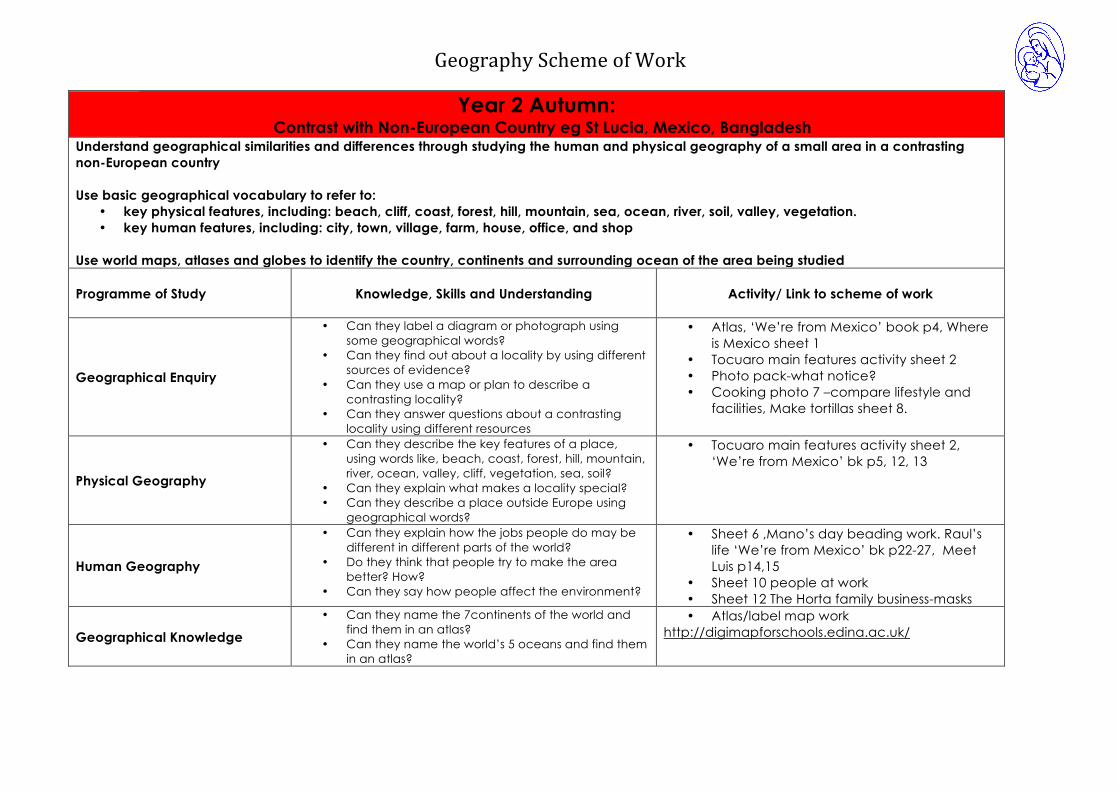
Year 2 Autumn: Contrast with Non-European Country eg St Lucia, Mexico, Bangladesh
Understand geographical similarities and differences through studying the human and physical geography of a small area in a contrasting non-European country Use basic geographical vocabulary to refer to:
• key physical features, including: beach, cliff, coast, forest, hill, mountain, sea, ocean, river, soil, valley, vegetation. • key human features, including: city, town, village, farm, house, office, and shop
Use world maps, atlases and globes to identify the country, continents and surrounding ocean of the area being studied Programme of Study
Knowledge, Skills and Understanding
Activity/ Link to scheme of work
Geographical Enquiry
• Can they label a diagram or photograph using some geographical words?
• Can they find out about a locality by using different sources of evidence?
• Can they use a map or plan to describe a contrasting locality?
• Can they answer questions about a contrasting locality using different resources
• Atlas, ‘We’re from Mexico’ book p4, Where is Mexico sheet 1
• Tocuaro main features activity sheet 2 • Photo pack-what notice? • Cooking photo 7 –compare lifestyle and
facilities, Make tortillas sheet 8.
Physical Geography
• Can they describe the key features of a place, using words like, beach, coast, forest, hill, mountain, river, ocean, valley, cliff, vegetation, sea, soil?
• Can they explain what makes a locality special? • Can they describe a place outside Europe using
geographical words?
• Tocuaro main features activity sheet 2, ‘We’re from Mexico’ bk p5, 12, 13
Human Geography
• Can they explain how the jobs people do may be different in different parts of the world?
• Do they think that people try to make the area better? How?
• Can they say how people affect the environment?
• Sheet 6 ,Mano’s day beading work. Raul’s life ‘We’re from Mexico’ bk p22-27, Meet Luis p14,15
• Sheet 10 people at work • Sheet 12 The Horta family business-masks
Geographical Knowledge • Can they name the 7continents of the world and
find them in an atlas? • Can they name the world’s 5 oceans and find them
in an atlas?
• Atlas/label map work http://digimapforschools.edina.ac.uk/

Geography Scheme of Work
Year 2 – Spring : Small area of the UK Understand geographical similarities and differences through studying the human and physical geography of a small area of the United Kingdom. use basic geographical vocabulary to refer to:
• key physical features, including: beach, cliff, coast, forest, hill, mountain, sea, ocean, river, soil, valley, vegetation. • key human features, including: city, town, village, farm, house, port, harbour and shop
Use world maps, atlases and globes to identify the United Kingdom and its countries Use aerial photographs and plan perspectives to recognise landmarks and basic human and physical features; devise a simple map; and use and construct basic symbols in a key Programme of Study
Knowledge, Skills and Understanding
Activity/ Link to scheme of work
Geographical Enquiry
• Can they label a diagram or photograph using some geographical words?
• Can they find out about a locality by using different sources of evidence?
• Can they find out about a locality by asking some relevant questions to someone else?
• Can they use a map or plan to describe a contrasting locality?
• Can they use symbols on a map? • Can they construct a map and use a key? • Can they say what they like and don’t like about their
locality and another locality like the seaside? • Can they write and present findings?
Choose photo from www.devon.gov.uk/dcs/geog/units/seas/index.html and label and add captions. Use geography success textbook p34-41. –comprehension exercises and quick on the drawer activity. Isle of Coll photo pack. In groups explore/investigate photo. Feedback to rest of class their findings about the Scottish Island. Hot seat character from Katie Morag or Lighthouse keeper story about seaside locality. Use google earth to zoom in on Isle of Coll to discuss what an island is. Use a map of Coll/Isle of Struay to identify features of an island home. Using Isle of Struay map consider what symbols mean e.g for lighthouse, golf course, battlefield, building, viewpoint, bridge, road etc. How can we find out what symbols mean? (key) Why use symbols on map? (less space needed) Mapwork 1 textbook p26/27 cracking the code. Make an imaginary map, design your own symbols and key to show what they mean.

Geography Scheme of Work
http://digimapforschools.edina.ac.uk/
Physical Geography
• Can they explain what makes a locality special? • Can they describe some places which are not near the
school? • Can they compare where we live to a Scottish Island • Can they describe some of the features associated with
an island? • Can they describe the key features of a place, using
words like, beach, coast, forest, hill, mountain, river, ocean, valley, cliff, vegetation, sea, soil?
Fragment the info activity/Jigsaw activity with laminated pieces of seaside pictures. What can you see? What type of place are they showing? How do you know? Feature names? Activities? Complete online activity to place seaside town names into correct position on map of England. Discuss that towns at the seaside are on the coast, edge of the land. Has anyone been to these places? Explore photos, seaside artefacts. Write description of beach/seaside setting. Isle of Coll photo pack. In groups explore/investigate photo. Feedback to rest of class their findings about the Scottish Island. Compare jobs, transport, buildings, houses, landscape (use hill, river vocab), traffic, entertainment facilities/activities between Isle of Coll and High Crompton. When completing Geography success comprehension use beach, coast, sea, ocean, cliff vocabulary. Discuss mountain, valley, vegetation, soil vocabulary. Discuss terms human/physical features. Highlight map of Struay using 2 colours to identify human/physical features.
Human Geography
• Can they describe some human features of their own locality, such as the jobs people do?
• Do they think that people ever spoil the area? How? • Can they explain what facilities a town or village might
need? • Can they describe the key features of a place, using
words like, city, town, village, farm, port, harbour
Isle of Coll photo pack. In groups explore/investigate photo. Feedback to rest of class their findings about the Scottish Island. Discuss what facilities a town like Oldham and a seaside village has. Discuss features of places using photos of harbor town like Whitby, Padstow and High Crompton e.g farming land and parks etc Which are essential? Would be needed in a community for it to survive e.g health facilities etc Compare jobs, transport, buildings, houses, landscape (use hill, river vocab), traffic,
Geography Scheme of Work
entertainment facilities/activities between Isle of Coll and High Crompton. How is our local environment spoilt? Recap on what discussed as Year 1 local area topic. Discuss terms human/physical features. Highlight map of Struay using 2 colours to identify human/physical features.
Geographical Knowledge
• Can they recall the four countries making up the United Kingdom and their capital cities? (From Year 1)
• Can they identify characteristics of the four countries, capital cities and its surrounding areas?
Geography Key Stage photocopiable masters p25. Label 4 countries in UK. Mark on where we live. Manchester/Oldham. Label London, Belfast, Edinburgh, Cardiff using globe and atlases for research. http://digimapforschools.edina.ac.uk/
Geography Scheme of Work
Year 2 Summer : Geographical Skills Use world maps, atlases and globes to identify the United Kingdom and its countries, as well as the countries, continents and oceans studied at this key stage Use simple compass directions (North, South, East and West) and locational and directional language [for example, near and far; left and right], to describe the location of features and routes on a map Use aerial photographs and plan perspectives to recognise landmarks and basic human and physical features; devise a simple map; and use and construct basic symbols in a key Programme of Study
Knowledge, Skills and Understanding
Activity/ Link to scheme of work
Geographical Enquiry
• Can they label a diagram or photograph using some geographical words?
• Can they find out about a locality by using different sources of evidence?
• Can they find the longest and shortest route a using map?
• Can they use grid references A1, B2 etc • Can they plan a journey to a place in our locality?
Complete grid reference activity of Isle of Struay map. Use a simple map with squares or dots at increments can they find different lengths routes to/from different locations. Write a journey to the park from the school gate using turn left, turn right, move forward xx spaces.
Physical Geography • Can they describe the key features of a place, using
words like, beach, coast, forest, hill, mountain, river, ocean, valley, cliff, vegetation, sea, soil? (Cover any vocab not already covered in previous topics)
Ongoing
Human Geography
• Can they say how people affect the environment? How is our local environment spoilt? School environment? What has changed where you lived in their living memory? For the better or worse? Give reasons. Recap on what discussed as Year 1 local area topic.
Geographical Knowledge
• Can they recall the four countries making up the United Kingdom and their capital cities? (From Year 1)
• Can they identify characteristic’s of the four countries, capital cities and its surrounding areas?
• Can they use aerial photographs? • Can they plan perspectives to recognise landmarks • Can they recognise basic human and physical features
on a map?
Geography Key Stage photocopiable masters p25. Label 4 countries in UK. Mark on where we live. Manchester/Oldham. Label London, Belfast, Edinburgh, Cardiff using globe and atlases for research. Recap seas around UK. Find one fact/characteristic about each of the 4 countries using different sources of information provided.

Geography Scheme of Work
• Can they use simple compass directions (North, South, East and West)
• Can they use locational and directional language, near and far, left and right.
• Can they create a route on a map?
Give one get one activity Mapwork 1 textbook –a bird’s eye view. Look at aerial photo of our school. What can you identify? Faster finger to… Use an overlay of map to show how map comes from an overhead view. What human/physical features can you see on the aerial photo? Complete Mapwork 1 textbook p14-15 follow a route. Complete Mapwork 1 textbook p16-17 compass directions. Complete Mapwork 1 textbook p22-23 treasure island. Describe a route eg start at B7 where the ship sank. Swim 4 right squares, down 3 squares and left 2 squares where am I? Can they write their own route for others to guess? Using left right. Now add on a 4 point compass to the map, describe a route eg start at B7 where the ship sank. Swim West 2 squares, South 4 squares and East 2 squares where am I? Can they write their own route for others to guess? Using N,S,E,W? http://digimapforschools.edina.ac.uk/

Geography Scheme of Work
Year 3 Summer : Rivers/mountains/UK Describe and understand key aspects of:
• physical geography, including: rivers, mountains and the water cycle. Name and locate within the United Kingdom key topographical features :
• hills, mountains, coasts and rivers
Use maps, atlases, globes and digital/computer mapping to locate countries and describe features studied. Use symbols and key (including the use of Ordnance Survey maps) to build their knowledge of the United Kingdom Use fieldwork to observe, measure, record and present the human and physical features in the local area using a range of methods, including sketch maps, plans and graphs, and digital technologies. (Covered in Y3 and Year 5) Programme of Study
Knowledge, Skills and Understanding
Activity/ Link to scheme of work
Geographical Enquiry Fieldwork
• Can they use correct geographical words to describe a place and the events that happen there?
• Can they label the same features both on an Arial photograph and a map?
• Can they observe, measure record and present human and physical features using a range of methods eg sketch maps, plans and graphs and use of digital technologies.
• Can they make careful measurements and use the data?
River study at Castleshaw Geographical dictionary activity. Label geographical features on aerial photos and maps. Draw maps from an aerial photo http://digimapforschools.edina.ac.uk/ Find features on map of Castleshaw area.

Geography Scheme of Work
Physical Geography
• Can they use maps and atlases appropriately by using contents and indexes?
• Can they use appropriate symbols to represent different physical features on a map?
• Can they explain why many cities of the world are situated by rivers?
• Can they explain how a location fits into its wider geographical location; with reference to physical features?
• Can they explain how the water cycle works? • Can they explain why water is such a valuable
commodity?
Learn how to use index and contents page in an atlas. OS work- understands use of symbols. Draw own maps with a key using symbols Link with ancient Egypt and River Nile. Research in atlases which capital cities are located by rivers. Choose a river to research. Water cycle from a geographical perspective (covered again in Year 5 from a scientific perspective). Label main features of water cycle. Write an explanation of how the water cycle operates. Link with ancient Egypt and River Nile, River Thames. Learn that some countries do not have enough water – link to climate. Explain how a river changes along its course. Espresso Rivers. Explore photos of land shaped by rivers. Link to rocks work.
Human Geography
• Can they explain why people are attracted to live
by rivers?
Espresso > Rivers- video of River Usk. Link to ancient Egypt and pre history work. Match drawings of different river settlements to descriptions. Mapping Rivers book. Mind map showing uses of rivers.
Geographical Knowledge
• Can they explain the difference between the British
Isles, Great Britain and UK? • Can they name up to six cities in the UK and locate
them on a map? • Can they locate and name some of the main
islands that surround the UK? • Can they name and locate many of the world’s
Use map of British Isles to show difference between UK and British Isles. Label UK countries and major cities on UK map. Locate major world rivers and mountain ranges- link to countries and continents. Plot on world map Locate Spanish rivers.

Geography Scheme of Work
major rivers on maps? • Can they name and locate many of the world’s
most famous mountain regions on maps?
Plot major UK rivers on UK map. Label with numbers and key. http://digimapforschools.edina.ac.uk/ Use atlas to find island surrounding UK and major UK cities.
Geography Scheme of Work
Year 4 Spring: UK Cities and Regions/European Countries/Region of Spain Locate the world’s countries, using maps to focus on Europe (including the location of Russia), concentrating on their environmental regions, key physical and human characteristics, countries, and major cities. Name and locate counties and cities of the United Kingdom, and their identifying human and physical characteristics, key topographical features (including hills, mountains, coasts and rivers). Understand geographical similarities and differences through the study of human and physical geography of a region in a European country. Human geography, including: types of settlement and land use, economic activity including trade links, and the distribution of natural resources including energy, food, minerals and water Use maps, atlases, globes and digital/computer mapping to locate countries and describe features studied Use the eight points of a compass, symbols and key (including the use of Ordnance Survey maps) to build their knowledge of the United Kingdom and the wider world Programme of Study
Knowledge, Skills and Understanding
Activity/ Link to scheme of work
Geographical Enquiry
• Do they use correct geographical words to describe a place and the events that happen there? Week 1
• Can they find the same place on a globe and in an atlas? Week 1
Week 1 •Check children's understanding of what a globe is and how to use it. Can we locate Spain on globe? Earth’s land is divided into 7 huge areas called continents. These are split into smaller areas called countries. Write continents on w/b. What continent is country of Spain in (Europe)? Display world map (remind children map is flattened globe), compare size of Europe to other continents – it’s small but has many countries. Locate Spain. What other countries form part of Europe? How does size of Spain compare to other European countries, e.g. compare Spain to UK. Is it bigger/smaller? Where a country joins another there are lines called borders. What countries lie on the borders of Spain (Portugal and France)? •Children use atlases to name European countries and create their own map of Europe. Use a different colour for each country. Use iPads, laptops

Geography Scheme of Work
and atlases to find the capital cities of important European countries. •Use Google Earth to locate Spain. Discuss its key features and name major towns and cities. Where have children visited in Spain? Children use atlases, iPads and laptops to create their own maps of Spain with key features and major towns and cities labelled. •Create a class map of Spain for display using papier mache and paint. Children create labels for key features and towns and cities.
Physical Geography
• Can they recognise the 8 points of the compass (N,NW, W, S, SW, SE, E, NE)? Week 1
• Can they describe the main features of a well-known city UK and Spain? Week 2
• Can they describe the main features of a village? Eg Shaw and Spanish Week 6
• Can they describe the main physical differences between cities and villages? Week 4
• Can they locate the Mediterranean and explain why it is a popular holiday destination? Week 7
Week 2 •Using Google Earth look at major cities in Spain. Discuss their location and features. Children use laptops and iPads to research a Spanish city in pairs or small groups. Children create a travel guide for their city. •We’ve looked at globes and maps - what other resources can we use to help us find out about a country? Display atlas: explain it’s a collection of maps, facts and info about countries. Remind children how to use atlas. We can also find atlases online. Demo example, e.g. MapQuest. Additional info can also be found on internet, e.g. country profile, see http://www.factmonster.com/countries.html or http://www.oddizzi.com/. Week 3 •Discuss reasons why people choose to live in a city. Children discuss advantages and disadvantages of living in a city. •BBC Clip: Why do people go to live in cities? •Look at children’s research of major Spanish cities (population, size, weather, key features etc.) and compare with Manchester. Discuss similarities and differences between Spanish cities and Manchester.
Geography Scheme of Work
Week 4 •Remind children of their work on cities and the reasons why people want to live in a city. Look at Google Earth and point out smaller towns and villages. Does everyone live in a city? Children think of reasons why people would rather live in a city than a village. •Children identity differences between cities and villages. Week 5 – Assessment Week
Human Geography
• Can they confidently describe human features in a locality? Week 3 & Week 6
• Can they explain why a place is like it is? Week 7
• Can they explain how the lives of people living in the Mediterranean would be different from their own? Week 8
• Can they explain why people are attracted to live in cities – UK or European? Week 3
• Can they explain why people may choose to live in a village rather than a city? Week 4
• Can they describe and understand economic activity including trade and the distribution of natural resources including food? Week 9
Week 6 •Using Google Earth locate the Spanish village of Castañeda. Discuss its features. Look at Spanish link school website http://www.colegioelhaya.com to find out more about the village. •Discuss features of Shaw (size, population, location etc.) and compare with the Spanish village of Castañeda. Week 7 •Have children visited the Mediterranean? Discuss places children have visited and what children already know about the Mediterranean. Using Google Earth locates the Mediterranean, discuss its features. Why is it a popular holiday destination? Discuss how its location makes it a popular holiday destination (on the coast, beaches, sea, southern Spain so nice weather (hot summers and mild winters)). Can children think of other reasons why the Mediterranean is a popular holiday destination? (Short flight from UK). •Children research a Mediterranean holiday resort and create an advert advertising that resort to UK families. Children should include the features discussed that make the Mediterranean a popular holiday destination. •Children create postcards imagining they are
Geography Scheme of Work
holidaying in a Mediterranean resort. Use laptops and iPads to find images of the Mediterranean for front of postcards. Week 8 •Discuss children’s typical day in Shaw. Create a timeline of a normal school day. •Children research Spanish schools and find out what a typical Spanish school day is like. •Children compare their typical day with a Spanish child. Why are the lives of people living in the Mediterranean different to lives of people living in Shaw? •Children write diaries as a Spanish child. •Link to Spanish school to find out about typical Spanish school days? Week 9 •Remind children of their work so far on the Mediterranean. What have we learnt so far? Can children think of jobs available in the Mediterranean based on its geographical features? Discuss industry, economic activity and types of employment in the Mediterranean. •Discuss reasons why people work. •Write a job advert for a job in the Mediterranean. Links to PSHE.
Geographical Knowledge
• Can they name and locate the world’s countries with a focus on Europe including Russia? Week 1
• Can they name and locate some well-known European countries? Week 1
• Can they name and locate the capital cities of neighbouring European countries? Week 1
• Are they aware of different weather in different parts of the world, especially Europe? Week 11
• Do they know the countries that make up the European Union? Week 10
Week 10 •Show children clip: http://www.bbc.co.uk/education/clips/zjb4wmn •Discuss reasons for the European Union from the video. •Children use laptops and iPads to research the countries that makes up the European Union. •Children colour in countries in the European Union on a map of Europe. Week 11 •Look at BBC site:

Geography Scheme of Work
• Can they name and locate cities and counties of the United Kingdom and their geographical region eg NW, NE etc….
http://www.bbc.co.uk/schools/whatisweather/ and discuss different types of weather. •What is the weather like in different parts of Spain? Discuss the weather in the UK and compare. Children research weather in different parts of Europe using iPads and laptops. •In pairs or small groups children research a different European country and create a weather report for that country. •Children present weather reports to the rest of the child. Compare weather in different countries. Where was the coldest place? Which country has the wettest weather? Which country was the hottest? •Do children understand that a country’s location affects its weather? Can children guess what the weather in a European country might be like based on its location? The Counties links with History and ‘shires’ in Anglo Saxons - Summer Term http://digimapforschools.edina.ac.uk/

Geography Scheme of Work
Year 5 Autumn: Climate Zones/Biomes/ Volcanoes and Earthquakes
Name and locate human and physical characteristics, key topographical features (including hills, mountains, coasts and rivers), and land-use patterns; and understand how some of these aspects have changed over time Describe and understand key aspects of:
• physical geography, including: climate zones, biomes and vegetation belts, volcanoes and earthquakes. • human geography, including: types of settlement and land use, economic activity including trade links, and the distribution of natural resources
including energy, food, minerals and water Geographical skills and fieldwork
• Use maps, atlases, globes and digital/computer mapping to locate countries and describe features studied • Use the symbols and key (including the use of Ordnance Survey maps) to build their knowledge of the United Kingdom and the wider world
Use fieldwork to observe, measure, record and present the human and physical features in the local area using a range of methods, including sketch maps, plans and graphs, and digital technologies. ( Build on from Year 3 – two year groups to do field study) Programme of Study
Knowledge, Skills and Understanding
Activity/ Link to scheme of work
Geographical Enquiry
• Can they collect information about a place and use it in a report eg Biomes?
• Can they use digital mapping to locate areas and describe features (biomes)
• Can they find possible answers to their own geographical questions?
Research and prepare a report about a biome of choice: arctic/ desert / mountain / marine. Use internet and atlas to map out key world biomes and label. Ask Qs of biomes and research possible answers: eg ‘Who lives near the North pole?’ Make charts and mind-map links http://digimapforschools.edina.ac.uk/
Physical Geography
• Can they describe how volcanoes are created? • Can they describe how earthquakes are created?
Watch videos of volcanic eruptions and after-effects. Make a model volcano erupt. Research local earth tremors caused by traffic – make a seismograph and record traffic impact on Rochdale Rd. Graph results & interpret DB levels / environmental impact.
Human Geography
• Can they describe how volcanoes have an impact on people’s lives?
Look at Pompeii images / map and comment on impact. The Eyjafjallajökull volcano and its effects on travel. How the Yellowstone supervolcano affected lives in

Geography Scheme of Work
the past and future implications.
Geographical Knowledge
• Can they locate and name some of the world’s most famous volcanoes?
• Can they name the largest desert and other biomes in the world?
Research and map out. How does the biome you are considering affect human settlement / food production and distribution of resources? Research and map out populations / food production and economic wealth of the region. Label key hills, regions, coasts, countries and rivers in climate zones.
Geography Scheme of Work
Year 5 Summer: Coasts/Region in the UK Name and locate human and physical characteristics, key topographical features (including hills, mountains, coasts and rivers), and land-use patterns; and understand how some of these aspects have changed over time – (Llandudno) Understand geographical similarities and differences through the study of human and physical geography of a region of the United Kingdom - Llandudno Describe and understand key aspects of:
• human geography, including: types of settlement and land use, economic activity including trade links, and the distribution of natural resources including energy, food, minerals and water
Geographical skills and fieldwork
• Use maps, atlases, globes and digital/computer mapping to locate countries and describe features studied • Use four figure grid references the symbols and key (including the use of Ordnance Survey maps) to build their knowledge of the United Kingdom and
the wider world Use fieldwork to observe, measure, record and present the human and physical features in the local area using a range of methods, including sketch maps, plans and graphs, and digital technologies. ( Build on from Year 3 – two year groups to do field study) Programme of Study
Knowledge, Skills and Understanding
Activity/ Link to scheme of work
Geographical Enquiry Fieldwork
• Can they identify key features of a locality by using a map?
• Can they begin to use 4 figure grid references? • Can they accurately plot NSEW on a map? • Can they use a range of OS map symbols? • Can they use OS maps to answer questions? • Can they make accurate measurement of
distances within 100Km? • Can they plan a journey to a place in England? • Can they observe, measure record and present
human and physical features using a range of methods eg sketch maps, plans and graphs and use of digital technologies.
• Can they map land use? • Can they choose the best way to collect
information needed and decide the most appropriate units of measure?
Need to go and visit Llandudno to get the fieldwork aspect included. Plan a journey From Oldham to Llandudno Observe footfall onto the pier Record number of vehicles passing a zebra crossing for a given time. Video the weather / take temperatures / measure rainfall? http://digimapforschools.edina.ac.uk/
Physical Geography • Can they confidently name physical features in a
locality • Can they explain why a locality has those features?
Llandudno – pier, marine drive, hotel count and beach facilities. Note findings.

Geography Scheme of Work
• Can they confidently describe physical features in a locality?
Human Geography
• Can they confidently name physical features in a locality
• Can they explain why a locality has those features? • Can they confidently describe human features in a
locality? • Can they explain why a place is like it is? • Can they explain how a locality has changed over
time with reference to human features? • Can they suggest different ways that a locality
could be changed and improved?
Visit copper mines in Llandudno – examine change over time (land use) Use the tram to climb to top of Great Orme visitor centre – collect visitor numbers / consider impact / environmental guided walk of the area with a warden. Collect photos of flora and fauna on the Orme. Consider how to ‘future-proof’ the Orme.
Geographical Knowledge
• Can they name and locate counties of the United Kingdom and their geographical region eg NW, NE etc…. ( Reinforce from prior learning)
Reinforce work on counties (year 4) by correctly identifying the county we live in, the county Llandudno is in the region Oldham and Llandudno are in and the country within Britain.

Geography Scheme of Work
Year 6 Autumn: Rainforest/South America
Locate the world’s countries, using maps to focus on North and South America, concentrating on their environmental regions, key physical and human characteristics, countries, and major cities. Place knowledge Understand geographical similarities and differences through the study of human and physical geography of a region within North or South America. Human and physical geography Describe and understand key aspects of:
• physical geography, including: climate zones, biomes and vegetation belts, rivers, mountains. • human geography, including: types of settlement and land use, economic activity including trade links, and the distribution of natural resources
including energy, food, minerals and water Geographical skills and fieldwork Use maps, atlases, globes and digital/computer mapping to locate countries and describe features studied Use the eight points of a compass, four and six-figure grid references, symbols and key (including the use of Ordnance Survey maps) to build their knowledge of the United Kingdom and the wider world Programme of Study
Knowledge, Skills and Understanding
Activity/ Link to scheme of work
Geographical Enquiry
Can they find the same place on a globe and in an atlas?
Can they locate the Tropic of Cancer and the Tropic of Capricorn.
Can they confidently explain scale and use maps with a range of scales?
Can they use maps, aerial photos, plans and web resources to describe what a locality might be like?
Can they use digital mapping to locate the area and describe features.
What are rainforests and where are the worlds rainforests? To locate and name the world’s continents. To recognise where Rainforests ‘sit’ in the world in relation to the Equator & the Tropics of Cancer & Capricorn. Using online maps, atlases etc to locate the world’s rainforests Possible use the eight points of a compass, four and six-figure grid references, symbols and key to locate specific rainforest locations – cities/ key places linked to forests. http://digimapforschools.edina.ac.uk/
Physical Geography
Can they confidently describe physical features in a locality?
What’s it like in a rainforest? What are rainforests? Layers of the rainforest – forest floor – Understory – Canopy – Emergents

Geography Scheme of Work
Can they give extended descriptions of the physical features of different places around the world? Can they describe how some places are similar and others are different in relation to their physical features?
Can they describe and understand vegetation belts
Amazon Rainforest and River (HOME TOPIC) What are the plants like in a rainforest? investigate some of the plants from rainforests and show how they are suited to their environment Introduce terms biome & vegetation belts Compare world biomes – e.g. rainforest v deserts. Non – statutory – Animals of the rainforest Possible Science links Can they describe the life cycles of common plants? Can they observe their local environment and draw conclusions about life-cycles, e.g. plants in the vegetable garden or flower border? Can they compare the life cycles of plants and animals in their local environment with the life cycles of those around the world, e.g. rainforests? Can they describe how living things are classified into broad groups according to common observable characteristics and based on similarities and differences including microorganisms, plants and animals? Can they give reasons for classifying plants based on specific characteristics? Can they explain why classification is important? Can they identify how plants are adapted to suit their environment in different ways and that adaptation may lead to evolution? Can they explain how some living things adapt to survive in extreme conditions?
Human Geography
Can they find different views about an environmental issue? What is their view? Can they explain how a location fits into its wider geographical location; with reference to human and economical features?
Can they explain what a place might be like in the future,
What’s it like for humans to live in the rainforest? Who lives in the forest? How do they use the forests for food, shelter, clothing, medicine etc Who has an interest in the rainforest and what drives that

Geography Scheme of Work
taking account of issues impacting on human features?
Can they give an extended description of the human features of different places around the world? Can they describe how some places are similar and others are different in relation to their human features? Can they describe and understand economic activity including trade and the distribution of natural resources including energy, minerals and water.
Can they describe and understand settlement and type of land use in South America?
interest e.g. residents – to live, loggers and wood companies, palm oil plantation owners, governments What is happening to rainforests? identify and explain different views held by people about an environmental issue/change; recognise and describe how people can improve or damage the environment in particular cases; Why must we protect rainforests?
http://geoknow.net/pages/forests.html Destructive activities within rainforests – reasons for, economic, lack of education, unaware of alternatives etc Logging http://www.rain-tree.com/facts.htm
http://www.bbc.co.uk/learningzone/clips/logging-endangers-the-rainforest-of-papua-new-guinea/8986.html
Agriculture, Mining, Destruction, Loss of culture, recognize selected physical and human processes and appreciate how these can change the character of places and environments studied; Understand that people live in in different areas of a country may lead very different lifestyles; identify and explain different views held by people about an environmental issue/change; recognize and describe how people can improve or damage the environment in particular cases; Global Warming recognize and describe how people can improve or damage the environment in particular cases; Extinction recognize and describe how people can improve or damage the environment in particular cases;

Geography Scheme of Work
How can we save rainforests? Possible TASC activities to find out/ investigate what is being done and what we can do to further improve the rainforest’s chances of survival. Charitable organizations National Parks Animal Sanctuaries Global Conferences
Geographical Knowledge
• Can they locate the USA and Canada on a world map and atlas?
• Can they locate and name the main countries in South America on a world map and atlas?
• Can they locate and name the major cities and
countries in North & South America?
? in S America - Deserts Mountains Rivers Flags http://digimapforschools.edina.ac.uk/

Geography Scheme of Work
Year 6 Summer: Geography Skills; Grid Ref’s, Time Zones …. Identify the position and significance of latitude, longitude, Equator, Northern Hemisphere, Southern Hemisphere, the Tropics of Cancer and Capricorn, Arctic and Antarctic Circle, the Prime/Greenwich Meridian and time zones (including day and night) Geographical skills : Use maps, atlases, globes and digital/computer mapping to locate countries and describe features studied Use the eight points of a compass, four and six-figure grid references, symbols and key (including the use of Ordnance Survey maps) to build their knowledge of the United Kingdom and the wider world Programme of Study
Knowledge, Skills and Understanding
Activity/ Link to scheme of work
Geographical Knowledge
• Can they locate the Tropic of Cancer and the Tropic of Capricorn?
• Can they name the main lines of latitude and meridian of longitude?
• Can they identify the position and significance of the
equator, northern hemisphere and southern hemisphere, Arctic and Antarctic circles?
Link to work on rainforests and South America Autumn term Understand that lines of latitude and longitude are imaginary lines They divide the world up so you can give an exact location. Latitude lines run from east to west (like the equator), and tell you how far north and south you are, but longitude lines go from north to south (like the Greenwich Meridian) and tell you how far east or west you are. They measure the angular position in degrees. The Tropic of Cancer is the circle marking the latitude 23.5 degrees north, where the sun is directly overhead at noon on June 21, the beginning of summer in the northern hemisphere. The Tropic of Capricorn is the circle marking the latitude 23.5 degrees south where the sun is directly overhead at noon on December 21, the beginning of winter in the northern hemisphere. When the lines were named 2000 years ago, the Sun was in the constellation of Capricorn during the winter solstice and Cancer during the summer solstice (hence the names). Now due to the precession of the

Geography Scheme of Work
• Can they explain how the time zones work including day and night, Prime/Greenwich Meridian?
• Can they accurately use a 4 and 6 figure grid reference
• Can they plan a journey to a place in another part of the world, taking account of distance and time?
• Can they plan a journey to another part of the world
which takes account of time zones?
equinoxes the Sun is no longer in these constellations during these times, but the names remain.
The equator is the circle where the Sun is directly overhead at noon on the equinoxes.
The Arctic and Antarctic Circles are located at ±66.5 degrees latitude. Note that 66.5 + 23.5 equals 90 degrees. This means that on December 21, when the Sun is directly over the Tropic of Capricorn at noon, it will not be visible from the Arctic Circle. So above the Arctic Circle, there is a period during the winter when the sun remains below the horizon. The same is true of the Antarctic Circle during Southern Hemisphere winter. On June 21st, when the sun is directly over the Tropic of Cancer at noon, it is not visible from below the Antarctic Circle. Seasons (The Earth’s tilt) What time will it be in _____ when it is _______ elsewhere. (Maths link / 24hour clock link). (UK) Reading of OS maps, recognising symbols – locating features. Planning a journey (to South America?) Flights, Flight times, Flight duration, Time difference, miles travelled, and mph? Etc. Could also include currency, predominant language, predominant religion, tourist attractions, climate, etc.