Embed Size (px)
Citation preview
GEOLOGIC CONTROLS FOR LANDSLIDES IN THE CENTRAL AMERICAN HIGHLANDS OF
NORTHERN EL SALVADOR
By
York W. Lewis
A REPORT
Submitted in partial fulfillment of the requirements for the degree of
Master of Science in Geological Engineering
Michigan Technological University 2008
This report, “Geologic Controls for Landslides in the Central American Highlands of Northern El Salvador” is hereby approved in partial fulfillment of the requirements for the Degree of MASTER OF SCIENCE IN GEOLOGICAL ENGINEERING.
Department: Geological and Mining Engineering and Sciences
_______________________________ STANLEY J. VITTON
Report Advisor
_______________________________ WAYNE D. PENNINGTON
Department Chair
Date___________________________
i
Acknowledgements My advisor Dr. Stanley J. Vitton; Drs. John S. Gierke and Zhanping You for being on my thesis committee; Dr. Bill Rose for his founding of the Masters International Program for Natural Hazards and for his support in country; National Science Foundation: Partnerships for International Research and Education Grant (NSF-PIRE 0530109); Dr. Robert Butler who mentored me throughout my undergraduate career and who encouraged me to pursue the Peace Corps Master International Program on Geologic Hazards through Michigan Technological University; Matt Patrick; Anna Colvin; the wonderful community of Canton San Francisco, Citala, Chalatenango, El Salvador who shared their lives with me for 2 years; Meredith Hermance; Paul Kozak; Erich Melville; Eric Pilsmaker; Giovani Molina; Manuel Diaz; Dr. Robert Rogers; Alma Amparo Martinez Argueta; Carlos Pullinger; Mike Wise; Rolando Barillas; Maria Marasigan; Claudia Martinez; Ashley Nelsen; Peace Corps; SNET and the Ministry of the Environment and Natural Resources; Rigoberto Melendez; the people of La Comuna in Antigua Ocotepeque; the Alcaldia of Citala (Edgardo and Lorenzo): Dr. Tim Eisele; Dr. George Robinson; Robert Baron; the Faculty and Staff of the MTU department of Geological and Mining Engineering and Sciences; Dr. Karl Peterson of the MTU Civil and Environmental Department for the use of his Environmental Scanning Electron Microscope; Brian Ott, Ellen Engberg, Adam Blankenbicker, Jarod Maggio, Cara Shonsey, and Drew Walters for their help in performing the Atterberg Limits.
In Memory of Dr. William J. Gregg
ii
Abstract El Salvador is subject to many natural hazards such as volcanic eruptions, earthquakes,
and hurricanes. One of the results from hurricanes and earthquakes are landslides. Most
of the destructive landslides in El Salvador are located near the ocean along the chain of
volcanoes and occur in younger deposits. Due to their experiences with earthquakes and
landslides, the people of El Salvador are aware of the risks of landslides. Consequently,
the government has established an organization named the Servicio Nacional de Estudios
Territoriales (SNET) to monitor seismic events and to the investigate landslides and the
risk they pose for the residents. The majority of their work, though, is concentrated in the
region of volcanic activity; mostly in the coastal regions of the country. The northern
more mountainous regions of the country have not been investigated to any great extent
although it contains some of the country’s largest landslides. SNET has requested that a
study in the northern mountains be conducted to better understand the potential for large
scale landslides that might affect population centers. The surface geology consists of
volcanic ash deposits both welded and non-welded underlain by volcanic rock mostly of
acidic composition. Due to the large lateral extent of the ash deposits, however, the
bedrock geology is not well understood. Being in a tropical environment the surface
layers have weathered into residual soils. What is striking about the residual soils is that
they remain at very steep angles. Slope angles, drainage morphology, and regional
geomorphology of the mountains are controlled by the tectonic stresses from the plate
iii
movements between the Cocos, North American, and Caribbean Plates. A key factor in
the stability of the residual soils is that they possess higher strength than traditional
weathered soils. This strength has been attributed to the presence of allophone, imogolite,
and halloysite, weathering products from the volcanic ash. An infinite slope model was
performed for residual soils overlaying bedrock indicating that, while the increased
strength is important, an additional factor in their stability is the buttressing effect of the
blanketing ash deposits. In many terrains where the infinite slope model is used, the
slopes have been formed by erosion or the cutting down of the valleys and through many
of the geologic layers. Once erosion occurs, leaving exposed surface layers, such as
residual soils, shallow landslides occur. Therefore in order to have deeper translational
landslides, the blanketing of a younger ash deposit, which eventually weathers to a
residual soil, over a paleo-rock surfaces must support the ash deposits and act as a
support mechanism until erosion cuts through the soil. In general, it was found that the
potential for large landslides in northern El Salvador that could affect population centers
is relatively low. What is apparent, though, is that due to its steep topography and high
rainfall the area is susceptible to smaller landslides, especially roads and highways that
have altered the slopes and drainages.
iv
Table of Contents Acknowledgements .............................................................................................................. i Abstract ............................................................................................................................... ii Table of Contents ............................................................................................................... iv List of Figures ..................................................................................................................... v List of Tables ................................................................................................................... viii I. Introduction ..................................................................................................................... 1 II. Background .................................................................................................................... 3
A. Recent Natural Disasters ...................................................................................... 3 B. Study Area: ........................................................................................................... 5
1. Previous Landslide Studies in the Region ........................................................ 6 2. Significant Regional Landslides in Northern El Salvador and Western Honduras ..................................................................................................................... 7
III. Geologic Background ................................................................................................. 14 A. Tectonic Setting .................................................................................................. 14 B. Regional Geology ............................................................................................... 17
IV. Field Work .................................................................................................................. 20 V. Structural and Geomorphological Analysis ................................................................. 22
A. Structural Analysis ............................................................................................. 22 B. Geomorphological Analysis ............................................................................... 29
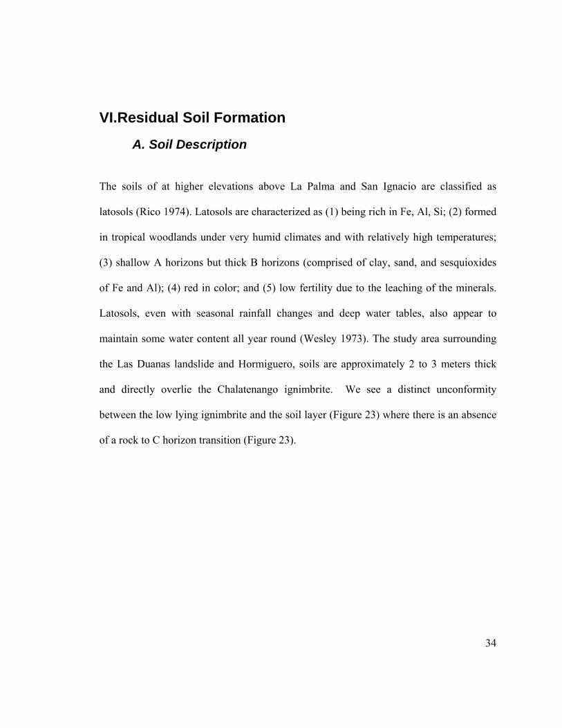
VI. Residual Soil Formation ............................................................................................. 34 A. Soil Description .................................................................................................. 34 B. Climate ............................................................................................................... 36
VII. Slope Stability Analysis ............................................................................................ 43 A. Slope Stability Parameters ................................................................................. 43 B. Infinite Slope Analysis ....................................................................................... 45 C. Allophane, Halloysite, and Imogolite ................................................................ 48 D. Hydrology........................................................................................................... 50
VIII. Discussion ................................................................................................................ 52 A. Tectonic Effects .................................................................................................. 52 B. Structural Controls ............................................................................................. 53 C. Weathering Controls .......................................................................................... 54 D. Hydrological controls ......................................................................................... 56 E. Anthropogenic Controls ..................................................................................... 58
IX. Conclusions................................................................................................................. 60 X. Recommendations ........................................................................................................ 61 XI. References ................................................................................................................... 64
v
List of Figures Figure 1 Location of El Salvador, Central America. .......................................................... 3 Figure 2 Location of study area. Figure shows the location of the municipalities of San
Ignacio and La Palma. (Figure created by author. (Spatial data provided by SNET). .................................................................................................................... 6
Figure 3 Photo of Antigua Ocotepeque taken in 1934 after the debris flow from Rio Marchala destroyed the city. Only the church appears to be standing. ................... 8
Figure 4 Photo of the landslide Zompopera. ....................................................................... 9 Figure 5 Photo of washed out portions of the road from La Palma to Miramundo at
Zompopera. ........................................................................................................... 10 Figure 6 Photo A shows in the background the washed out road at Zompopera in June of
2008. Photo B shows the road at Zompopera before it had completely washed away and the recently constructed detour around the original path in November of 2006....................................................................................................................... 10
Figure 7 Photo of snack truck just passing the Zompopera landslide. Heavy commercial traffic is at a high risk of causing or being caught in slope failures on the weakened roads at the Zompopera scarp. ............................................................. 11
Figure 8 Photos of road destroyed by heavy rains in September of 2006. The Ministry of Public Works constructed a temporary bailey bridge until reconstruction of a permanent structure could be built. ....................................................................... 12
Figure 9 Photo from CEPRODE of Hormiguero taken several months after the landslide occurred. The road was redirected along the top of the scarp. ............................. 13
Figure 10 Map of Northern Central America showing regional extension in the form of grabens due to distal stresses from the North American and Caribbean Plate motion (Modified from Lyon-Caen, Et al). .......................................................... 16
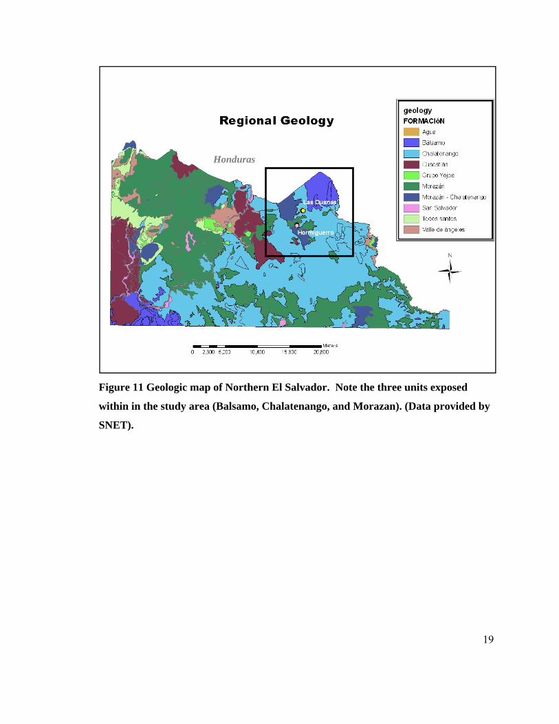
Figure 11 Geologic map of Northern El Salvador. Note the three units exposed within in the study area (Balsamo, Chalatenango, and Morazan). (Data provided by SNET)................................................................................................................................ 19
Figure 12 Photo of the landslide at the village of Bella Vista, locally known as Hormiguero. .......................................................................................................... 20
Figure 13 Photo of the landslide at the village of Las Duanas. ........................................ 21 Figure 14 3 dimensional shaded relief map showing the Rio Lempa graben and regional
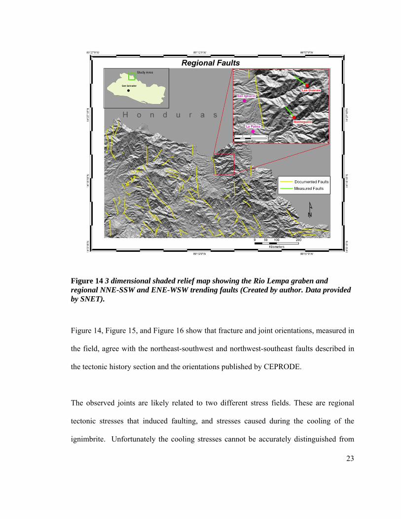
NNE-SSW and ENE-WSW trending faults (Created by author. Data provided by SNET). ................................................................................................................... 23
Figure 15 northwest-southeast trending fault blocks with the landslide Hormiguero in bottom foreground (left). Additional photo of northwest-southeast trending fault blocks from the road at Hormiguero (right). These are believed to be associated with the current regional extension caused by the Motagua fault movement between the North America plate and the Caribbean plate. ................................. 24
Figure 16 Stereonets representing measured joint and fault orientations for Hormiguero, Las Duanas, and the total combined measurements at both landslides. The majority of orientations dip toward the southeast and southwest. This suggests that rock failure is more likely to occur on the south-facing slopes, though no
vi
evidence of rock slides has been observed nor documented. Other orientations represented above parallel the regional fault trends. ............................................ 25
Figure 17 Point Load Tests of Ignimbrite samples taken from Las Duanas and Hormiguero. Measurements vary due to the changes in degree of weathering. ... 26
Figure 18 Photo of Ignimbrite weathering to clay. These clays are believed to have been developed by groundwater seeping through joints within the ignimbrite bedrock................................................................................................................................ 28
Figure 19 Detailed topography of the Las Duanas area. Note the steep terrain in a small watershed. The potential for other landslides to occur is high. (Spatial data provided by SNET) ............................................................................................... 30
Figure 20 Note the dominant slope angles within the landslide are between 30 and 50 degrees. The surrounding area has slopes that are predominantly between 30 and 50 degrees with a small area that measure more than 5 degrees. These steep slopes are expected to fail like the landslide at Las Duanas. (Spatial data provided by SNET). .................................................................................................................. 31
Figure 21 Detailed topography of the Hormiguero landslide area show less steep terrain, in a small northeast-southwest trending drainage, than Las Duanas. (Spatial data provided by SNET) ............................................................................................... 32
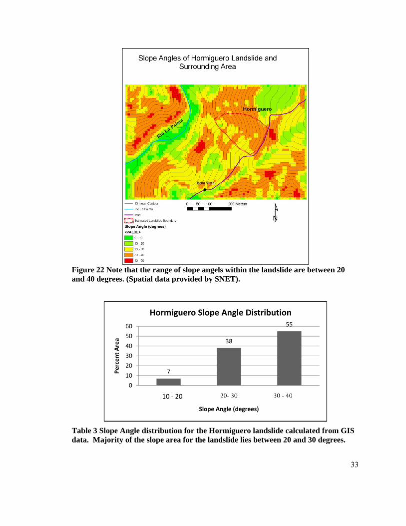
Figure 22 Note that the range of slope angels within the landslide are between 20 and 40 degrees. (Spatial data provided by SNET). ........................................................... 33
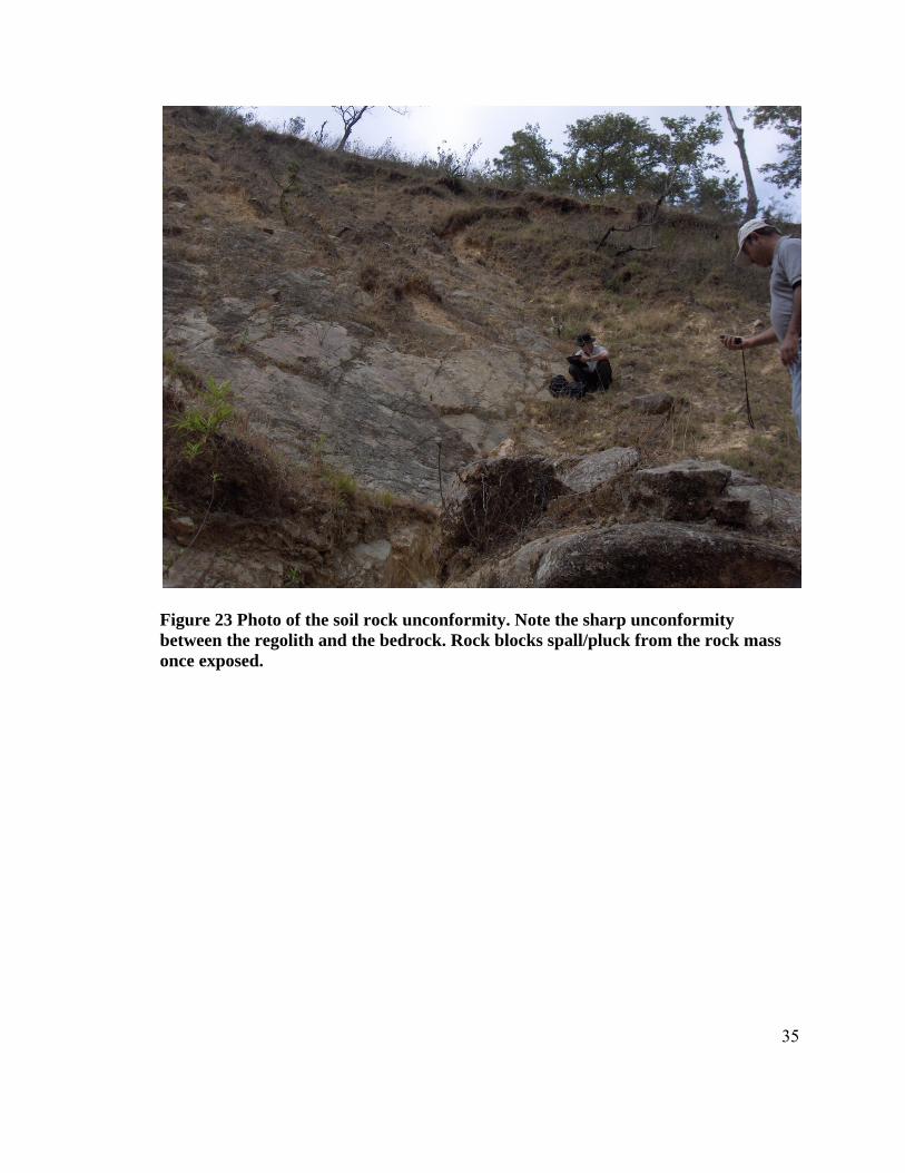
Figure 23 Photo of the soil rock unconformity. Note the sharp unconformity between the regolith and the bedrock. Rock blocks spall/pluck from the rock mass once exposed. ................................................................................................................ 35
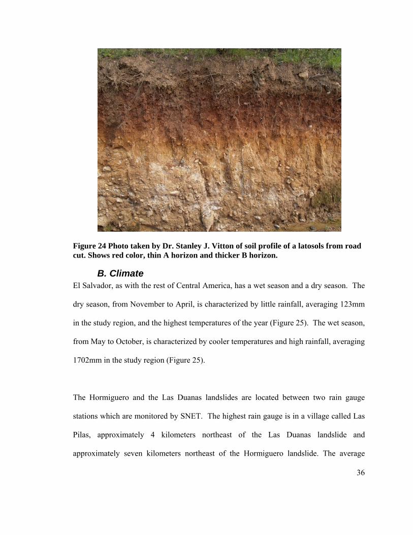
Figure 24 Photo taken by Dr. Stanley J. Vitton of soil profile of a latosols from road cut. Shows red color, thin A horizon and thicker B horizon. ...................................... 36
Figure 25 Most landslides occur in the wet months, May through October. (Data provided by SNET). .............................................................................................. 37
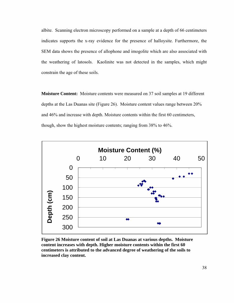
Figure 26 Moisture content of soil at Las Duanas at various depths. Moisture content increases with depth. Higher moisture contents within the first 60 centimeters is attributed to the advanced degree of weathering of the soils to increased clay content. .................................................................................................................. 38
Figure 27 Grain size distribution of 3 soil samples collected at 66 cm (triangles), 145 cm (squares), and 153 (diamonds) cm the Las Duanas Landslide. ............................. 40
Figure 28 Photo taken by author of beige-colored film on washed particles larger than #200 sieve. ............................................................................................................ 42
Figure 29 SEM images taken by author of Halloysite develops tubular structure (Photo1), Allophane exhibits spherical structures (Photo 2), and Imogolite exhibits threads that tend to adhere together (Photo4). When dried, Allophane and imogolite coat and bind soil particles together (Photo3). ............................................................. 42
Figure 30 Photo of smaller slope failure at the base of the Las Duanas Landslide. Note the soil mass that has slide down the rock surface. ............................................... 44
Figure 31 Geometry of Infinite Slope Analysis; 100% saturation and parallel groundwater flow. Where: N = normal force, S = shear force, W = weight of block. ............. 47
vii
Figure 32 Illustration showing the geologic formation of the northern mountains of El Salvador. Between 10 and 20 M.A. the late-miocene ignimbrite flare up deposits ash on unknown bedrock (block 1.). Between 3-10 M.A. an extensional tectonic event on the Caribbean plate produces a series of east-west striking half grabens where the rivers La Palma and San Ignacio form (block 2.). Sometime after the east-west extension, the North America-Caribbean plate motion causes the distal extension of northern Central America that forms the northwest-southeast trending Ipala, Sula, and the Ocotepeque grabens and possibly the parallel running smaller valleys within the mountains (not shown). Block 3 shows the blanketing of a poorly welded tuff on the uplifted topography. Soil development of the poorly welded tuff while stream cutting through the poorly welded tuff undercuts the natural buttress created between the opposing slopes (block4). Once buttressing support is removed, soils slide along the paleo-surface of the ignimbrite in a translational manner. .................................................................... 57
Figure 33 Slope failure Outside the Village of Teocinte. ................................................. 58 Figure 34 Small landslides along road cuts dot the roads after heavy rainfall during the
rainy season. .......................................................................................................... 59
viii
List of Tables Table 1 Atterberg limits of six clay samples. Due to high levels of sand, the plastic limit
could not be accurately determined for the last sample from the Hormiguero sight................................................................................................................................ 28
Table 2 Slope Angle distribution for the Landslide at Las Duanas calculated from GIS data. The majority of the area within the landslide falls between 40 and 50 degrees. ................................................................................................................. 31
Table 3 Slope Angle distribution for the Hormiguero landslide calculated from GIS data. Majority of the slope area for the landslide lies between 20 and 30 degrees. ...... 33
Table 4 Atterberg limits for soil samples from the Las Duanas landslide. Samples exhibit nonplastic to slightly plastic behavior. ................................................................. 39
1
I.Introduction
Natural hazards are a major problem in Central America (Rose et al., 2004). El Salvador
is located on the western side of Central America on the Pacific Ocean. While it is the
smallest country in Central America (21,040 km2), it has the highest population density in
Central America at 304/km2 (2001). According to Rose (2004), El Salvador “borders the
Middle American Trench, the active subduction boundary, and the seismic zone between
the Cocos and Caribbean plates.” As a consequence of plate subduction, El Salvador is
bisected by the volcanic front, a linear belt of active volcanoes and accompanying
seismic zone (Figure 1) with coastal plains to the south and the mountains to the north.
Thus, El Salvador is subject to many natural disasters including volcanic eruptions,
earthquakes, landslides, and hurricanes. With the increase in population within this
already densely populated country, the effects of natural disasters have become evermore
serious.
The majority of the natural disasters in El Salvador, therefore, are concentrated along the
volcanic chain, which happens to be where the large population centers are also located.
Past natural-disaster studies have therefore been focused along this region. Among these
studies is an extensive study done by the Japan Society of Civil Engineers on the January
13th 2001 earthquake and the damages caused to buildings, dwellings, and infrastructure.
One of their foci was the damage done by the Las Colinas landslide that was induced by
seismic energy (JSCE 2001). After Hurricane Mitch, the USGS sent a special task force
2
to inventory the landslides induced by the hurricane in El Salvador. Landslides were
recorded throughout the country with the most damaging landslides concentrated along
the volcanic chain region.
After Hurricane Mitch and the 2001 earthquakes, the Salvadorian government established
the agency, Servicio Nacional de Estudios Territoriales (SNET), within the Ministerio de
Medioambiente y Recursos Naturales (Rose et al. 2004). SNET is charged with the
responsibility of mitigating natural hazards through hazard characterization, monitoring,
education, and other ways (Rose et al, 2004).
The northern mountains of El Salvador which are part of the Central American Highlands
have a lower population but also have a lower risk of earthquake damage, volcanic
eruptions, and flooding. Rainfall induced landslides, however, pose a serious threat to the
population and infrastructure of the region. The purpose of this study is to characterize
the slope conditions and identify the mechanisms of slope failure in this region. The
information in this investigation can provide government agencies, such as SNET, with
an improved understanding of the risks potentially aid in improving early warning
systems for landslides in the region.
3
II.Background
A. Recent Natural Disasters
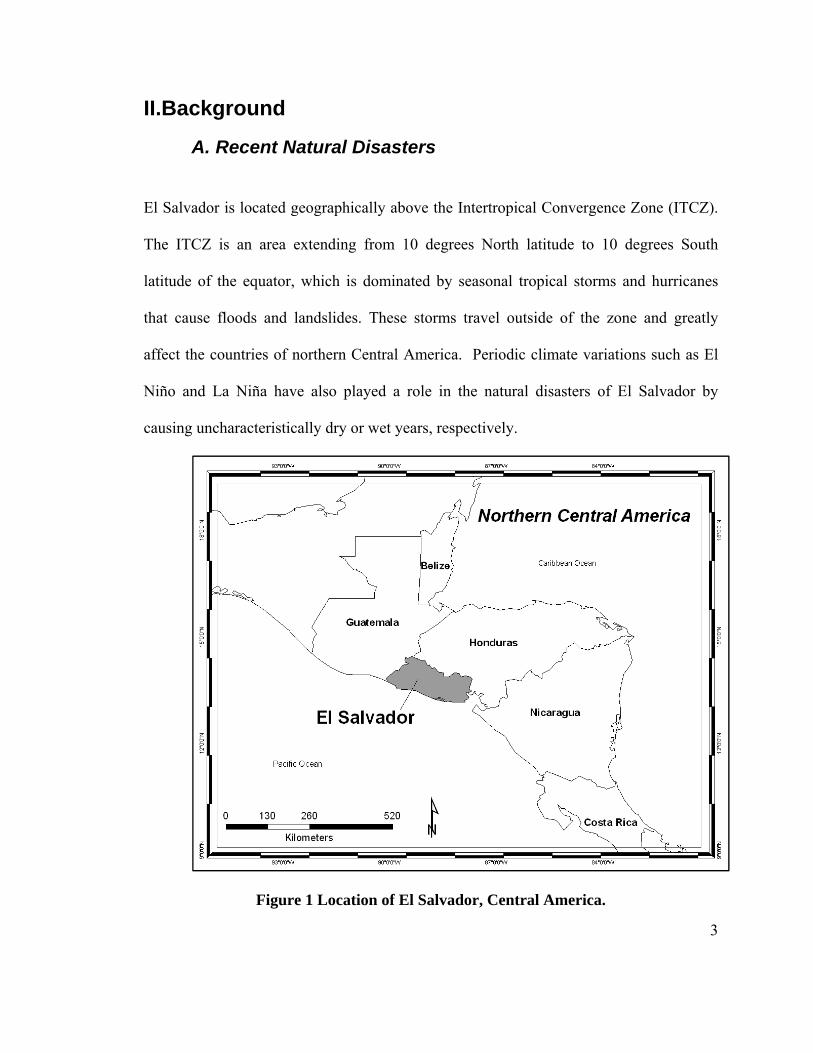
El Salvador is located geographically above the Intertropical Convergence Zone (ITCZ).
The ITCZ is an area extending from 10 degrees North latitude to 10 degrees South
latitude of the equator, which is dominated by seasonal tropical storms and hurricanes
that cause floods and landslides. These storms travel outside of the zone and greatly
affect the countries of northern Central America. Periodic climate variations such as El
Niño and La Niña have also played a role in the natural disasters of El Salvador by
causing uncharacteristically dry or wet years, respectively.
Figure 1 Location of El Salvador, Central America.
4
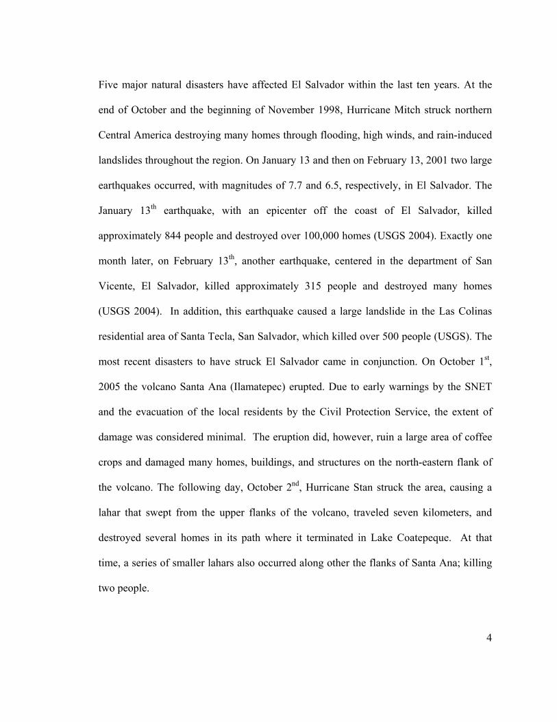
Five major natural disasters have affected El Salvador within the last ten years. At the
end of October and the beginning of November 1998, Hurricane Mitch struck northern
Central America destroying many homes through flooding, high winds, and rain-induced
landslides throughout the region. On January 13 and then on February 13, 2001 two large
earthquakes occurred, with magnitudes of 7.7 and 6.5, respectively, in El Salvador. The
January 13th earthquake, with an epicenter off the coast of El Salvador, killed
approximately 844 people and destroyed over 100,000 homes (USGS 2004). Exactly one
month later, on February 13th, another earthquake, centered in the department of San
Vicente, El Salvador, killed approximately 315 people and destroyed many homes
(USGS 2004). In addition, this earthquake caused a large landslide in the Las Colinas
residential area of Santa Tecla, San Salvador, which killed over 500 people (USGS). The
most recent disasters to have struck El Salvador came in conjunction. On October 1st,
2005 the volcano Santa Ana (Ilamatepec) erupted. Due to early warnings by the SNET
and the evacuation of the local residents by the Civil Protection Service, the extent of
damage was considered minimal. The eruption did, however, ruin a large area of coffee
crops and damaged many homes, buildings, and structures on the north-eastern flank of
the volcano. The following day, October 2nd, Hurricane Stan struck the area, causing a
lahar that swept from the upper flanks of the volcano, traveled seven kilometers, and
destroyed several homes in its path where it terminated in Lake Coatepeque. At that
time, a series of smaller lahars also occurred along other the flanks of Santa Ana; killing
two people.

5
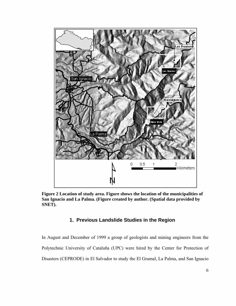
B. Study Area: One of the most interesting characteristics of the northern portion of El Salvador is that it
is dominated by steep slopes but yet has very few slope stability issues. This study
examines two landslides in northern El Salvador located in the Department of
Chalatenango. One landslide is located at the village of Las Duanas, within the
municipality of San Ignacio (Figure 2). The other landslide, named Hormiguero by the
locals, is at the village of Bella Vista in the municipality of La Palma (Figure 2). These
sites are located in the northern mountains of El Salvador which make up part of the
southern edge of the Central American Highlands and have received little attention
because of personnel and resources limitations within the country. The damage to
infrastructure is a seasonal challenge and danger to the local people and traffic.
6
Figure 2 Location of study area. Figure shows the location of the municipalities of San Ignacio and La Palma. (Figure created by author. (Spatial data provided by SNET).
1. Previous Landslide Studies in the Region
In August and December of 1999 a group of geologists and mining engineers from the
Polytechnic University of Cataluña (UPC) were hired by the Center for Protection of
Disasters (CEPRODE) in El Salvador to study the El Gramal, La Palma, and San Ignacio
7
Micro-catchments. This was commissioned in response to growing concerns about
landslide hazards in the region by local residents and government officials after
Hurricane Mitch in 1999. The objective of this study was to analyze the physical and
anthropogenic factors that affect slope stability in the region and to propose short-term,
mid-term, and long-term measures in order to reduce these hazards (CEPRODE). This
study aims to further develop the observations and results of the previous work conducted
by CEPRODE and the team from the UPC.
2. Significant Regional Landslides in Northern El Salvador and Western Honduras
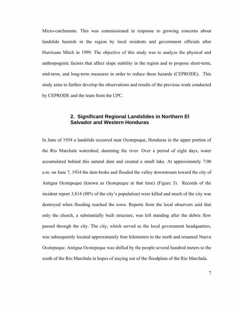
In June of 1934 a landslide occurred near Ocotepeque, Honduras in the upper portion of
the Rio Marchala watershed; damming the river. Over a period of eight days, water
accumulated behind this natural dam and created a small lake. At approximately 7:00
a.m. on June 7, 1934 the dam broke and flooded the valley downstream toward the city of
Antigua Ocotepeque (known as Ocotepeque at that time) (Figure 3). Records of the
incident report 3,814 (88% of the city’s population) were killed and much of the city was
destroyed when flooding reached the town. Reports from the local observers said that
only the church, a substantially built structure, was left standing after the debris flow
passed through the city. The city, which served as the local government headquarters,
was subsequently located approximately four kilometers to the north and renamed Nueva
Ocotepeque. Antigua Ocotepeque was shifted by the people several hundred meters to the
south of the Rio Marchala in hopes of staying out of the floodplain of the Rio Marchala.
FM
A
S
(F
b
in
th
gr
th
n
co
v
Figure 3 PhoMarchala de
Another sign
alvador. Ac
Figure 4) be
ecome the la
n Central Am
he road that
rowing and
he road farth
o longer be
ommercial t
illages at the
oto of Antigestroyed the
nificant histo
ccording to l
egan roughly
argest active
merica. The
wraps aroun
other agricu
her up on the
e moved (Fi
traffic that u
e top of the
ua Ocotepee city. Only
oric landslid
local residen
y 50 years a
e landslide in
problems p
nd the scarp
ultural uses.
e ridge, but t
igure 5, Fig
use this road
mountains (
eque taken ithe church
de occurs w
nts, the land
ago. Since i
n El Salvado
osed by this
of the landsl
The local g
the road has
gure 6). Th
in order to
Figure 7). O
n 1934 afterappears to
within the m
dslide compl
its initiation
or and one of
s landslide a
lide and the
government’
currently re
his is an on
reach the to
Other attemp
r the debrisbe standing
municipality
lex, named “
n, the landsli
f the largest
are the conti
loss of ferti
s response h
eached its up
ngoing risk
own of Miram
ts at prevent
s flow from g.
of La Palm
“La Zompop
ide has grow
active lands
inuous erosio
le land for c
has been to m
pper limit and
to the local
mundo and
ting further
8
Rio
ma, El
pera”
wn to
slides
on of
coffee
move
d can
l and
other
slope
9
failures have been the planting of grasses and small shrubs in order to anchor the soil.
Since the failures are at bedrock/soil interface, the planting has been relatively ineffective
at stabilizing the slopes.
Figure 4 Photo of the landslide Zompopera.
FZ
FJwN
Figure 5 PhoZompopera.
Figure 6 Phoune of 2008
washed awayNovember of
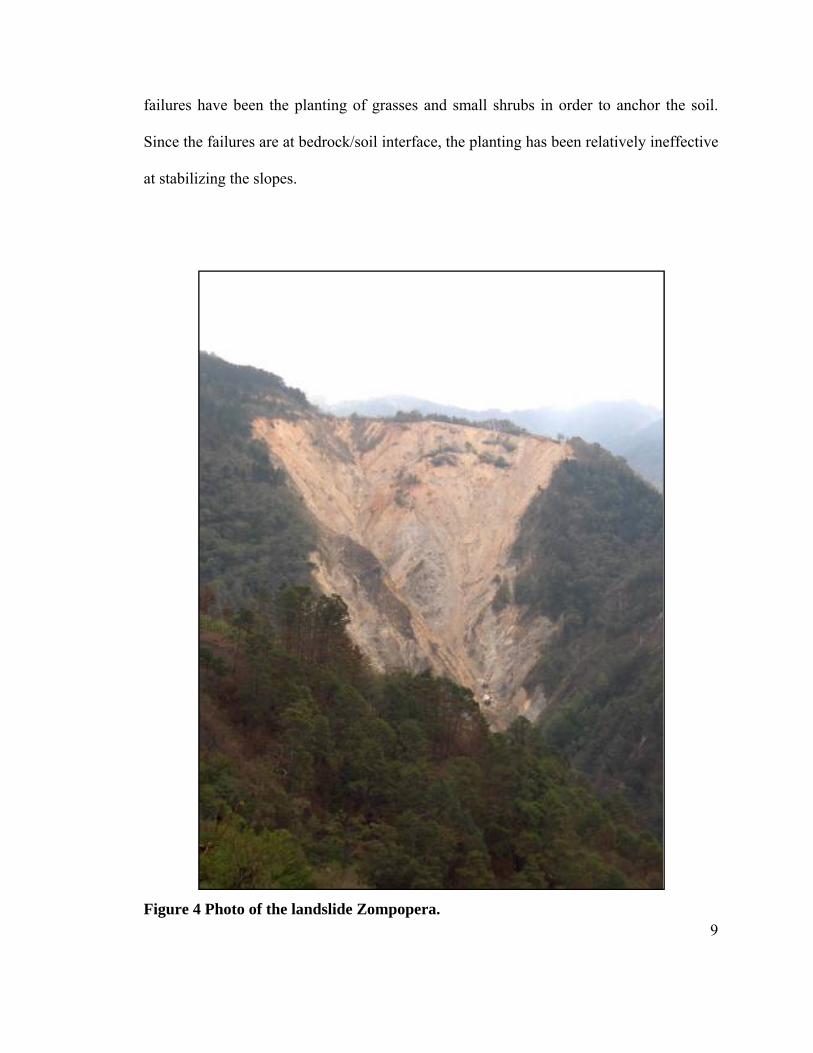
oto of washe
oto A shows8. Photo B sy and the ref 2006.
ed out porti
s in the backshows the roecently cons
ions of the r
kground theoad at Zompstructed det
A
road from L
e washed oupopera befo
tour around
La Palma to
ut road at Zoore it had cod the origina
Miramund
ompopera iompletely al path in
10
do at
in
B
11
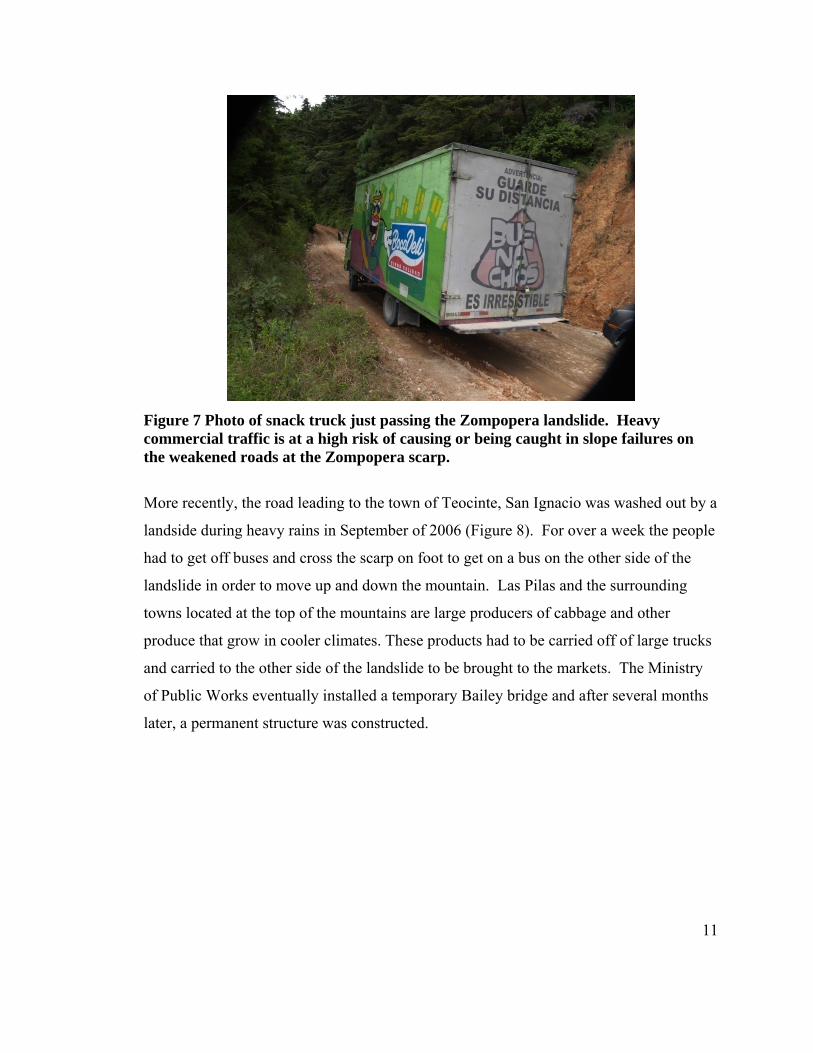
Figure 7 Photo of snack truck just passing the Zompopera landslide. Heavy commercial traffic is at a high risk of causing or being caught in slope failures on the weakened roads at the Zompopera scarp.
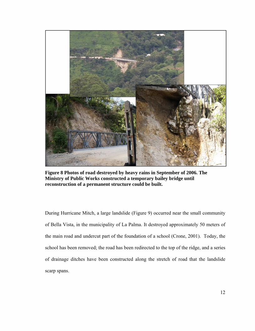
More recently, the road leading to the town of Teocinte, San Ignacio was washed out by a
landside during heavy rains in September of 2006 (Figure 8). For over a week the people
had to get off buses and cross the scarp on foot to get on a bus on the other side of the
landslide in order to move up and down the mountain. Las Pilas and the surrounding
towns located at the top of the mountains are large producers of cabbage and other
produce that grow in cooler climates. These products had to be carried off of large trucks
and carried to the other side of the landslide to be brought to the markets. The Ministry
of Public Works eventually installed a temporary Bailey bridge and after several months
later, a permanent structure was constructed.
12
Figure 8 Photos of road destroyed by heavy rains in September of 2006. The Ministry of Public Works constructed a temporary bailey bridge until reconstruction of a permanent structure could be built.
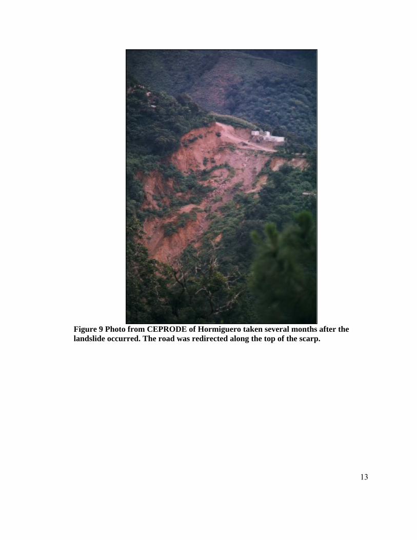
During Hurricane Mitch, a large landslide (Figure 9) occurred near the small community
of Bella Vista, in the municipality of La Palma. It destroyed approximately 50 meters of
the main road and undercut part of the foundation of a school (Crone, 2001). Today, the
school has been removed; the road has been redirected to the top of the ridge, and a series
of drainage ditches have been constructed along the stretch of road that the landslide
scarp spans.
13
Figure 9 Photo from CEPRODE of Hormiguero taken several months after the landslide occurred. The road was redirected along the top of the scarp.
14
III.Geologic Background
A. Tectonic Setting
Due to extensive volcanic activity, pyroclastic flows have blanketed the region with
significant thickness of ignimbrites. As a consequence, the geology of the northern
mountains of El Salvador is not well known. The majority of geological background for
this section is inferred by the work of Baxter (1984), Mann (2006), and Rogers (2002).
The northern mountains of El Salvador are believed to be at the edge of the Central
American Highland, associated with the Chortis Block (Rogers 2002). There appears to
have been three tectonic events that have had the greatest affect on the morphology and
structure of the northern mountain range of El Salvador.
The first and oldest event was the middle Miocene silicic ignimbrite flare-up which lasted
roughly 10 million years; and ended abruptly 10 M.A. B.P. This extrusive event
deposited up to 2 kilometers of ash on the southern borders of the Chortis Block (Figure
32) (Rogers 2002).
The second event was the North-South extension of the region sometime after the
deposition of the Miocene-aged ignimbrite (Figure 32). This extensional event may have
been the result of orthogonal subduction of the Cocos Plate underneath the Caribbean
plate and thus causing a series of east to west trending half grabens (Mann 2006).
15
Rogers (2002) presents another possible explanation for this extensional period.
According to Rogers the Central American Highlands were uplifted 3 to 5 M.A. as a
result of mantle upwelling between the subducting Cocos plate and the ruptured slab of
the Cocos plate being subducted underneath the Caribbean plate. The introduction of
buoyant mantle material rising toward the surface may have caused mostly vertical uplift
with little or no tilting of the Caribbean plate (Rogers 2002). It is possible that the distal
edges of this block (known as the Chortis Block) may have been involved in this uplift,
with a series of east to west trending half grabens developing between the coast and the
uplifted Chortis Block. This hypothesis was offered as a possible explanation for the
east-west extensional features that are observed throughout the region.
The third event was the east-west extension of the Central American Highlands. This was
caused by activity along the left-lateral Motagua translational fault in Guatemala. This
extension is believed to be responsible for the development of the upper Rio Lempa
watershed, the North-South system of faults, and the associated north-south trending
drainages that are the locations for many of the landslides in the region and the landslides
studied by this investigation (Figure 14).
Since the formation of the Central American Range, the western portion has been
continuously extending, forming terrains dominated by northeast-southwest running
horsts and grabens. This is most likely the result of the distal effects of the left lateral
16
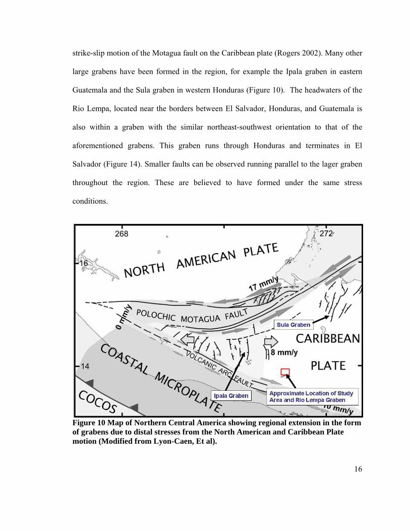
strike-slip motion of the Motagua fault on the Caribbean plate (Rogers 2002). Many other
large grabens have been formed in the region, for example the Ipala graben in eastern
Guatemala and the Sula graben in western Honduras (Figure 10). The headwaters of the
Rio Lempa, located near the borders between El Salvador, Honduras, and Guatemala is
also within a graben with the similar northeast-southwest orientation to that of the
aforementioned grabens. This graben runs through Honduras and terminates in El
Salvador (Figure 14). Smaller faults can be observed running parallel to the lager graben
throughout the region. These are believed to have formed under the same stress
conditions.
Figure 10 Map of Northern Central America showing regional extension in the form of grabens due to distal stresses from the North American and Caribbean Plate motion (Modified from Lyon-Caen, Et al).
17
B. Regional Geology
The study area is dominated by three rock units, which overlie an unknown basement
rock type (Figure 11). The three rock units are the Morazan, Chalatenango, and Balsamo,
which are briefly discussed below. It is believed that the basement rock is composed of
cretaceous backarc clastic redbeds or metamorphosed crystalline basement rock
(Sigurdsson et al 2000). These three units are associated with the late Miocene ignimbrite
flare-up and are mainly effusive with some interspersed intrusive units.
The Morazan formation is the oldest of the three units, Oligocene in age and has a
thickness greater than 650 meters. It has been assumed to be part of the Matagalpa
formation located in southern Honduras (Baxter 1984). The Morazan formation contains
intermediate effusives to intermediate-acidic and minor pyroclastics with scattered areas
silicified by contact metamorphism or hydrothermal alteration (Baxter 1984). This
formation is located at lower elevations and may be present at the Hormiguero study site
(Figure 11).
The Chalatenango – Morazan Intrusives (Figure 11) are a series of dikes and sills that
are most likely associated with increased volcanism during the tertiary (Baxter 1984).
According to previous studies in the La Palma region the bodies are composed of
granodiorite-monzonites to tonalite-diorite (Baxter 1984). There are no known exact
ages to these intrusive bodies (Baxter 1984). Dikes have been observed in the landslide
scarps of the Las Duanas and Hormiguero landslides.
18
The Chalatenango formation, with a thickness greater than 500 meters, is characterized
as a sequence of acidic volcanic rocks pyroclastic, ignimbritic, and epiclastic volcanic
(Baxter 1984). According to Baxter, the Chalatenango formation is located
stratigraphicaly between the Morazan formation and the Bálsamo formation. The
Chalatenango formation is split into two members, ch1 and ch2, based on slight
compositional differences. According to geologic maps, ch2 does not appear in the study
area. The ch1 member is present in the study area and is defined as acidic pyroclastics,
epiclastic volcanics, ignimbrites, and intercalated effusives which are locally
silicified/siliceous (Baxter 1984). This unit seems to be the dominant unit in the study
region (Figure 11).
The uppermost of the three units, the Balsamo formation, is divided into 3 members; b1,
b2, and b3 with an age of Miocene-Pliocene (Figure 11) (Baxter 1984). Chemically the
unit is acidic to intermediate in the lower sections then changes into a more basic
composition in the upper sections (Baxter 1984). The Balsamo formation appears to be
confined to the higher elevations within the study region and not present at the two
landslides described by this study.
19
Figure 11 Geologic map of Northern El Salvador. Note the three units exposed
within in the study area (Balsamo, Chalatenango, and Morazan). (Data provided by
SNET).
Honduras
20
IV.Field Work
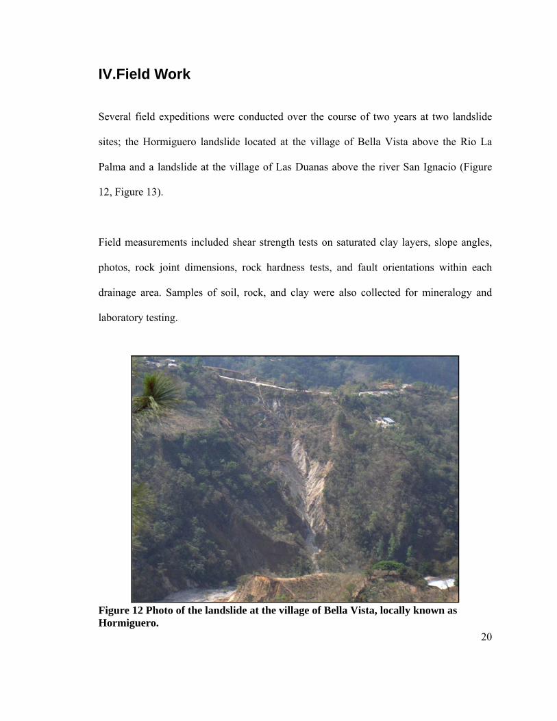
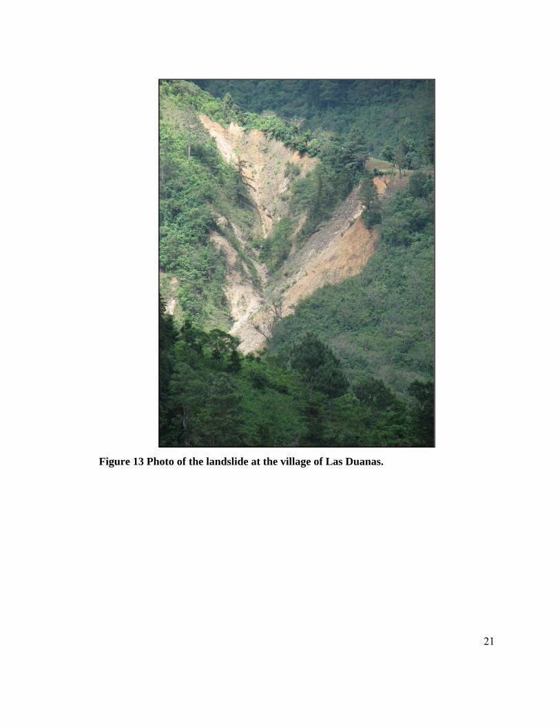
Several field expeditions were conducted over the course of two years at two landslide
sites; the Hormiguero landslide located at the village of Bella Vista above the Rio La
Palma and a landslide at the village of Las Duanas above the river San Ignacio (Figure
12, Figure 13).
Field measurements included shear strength tests on saturated clay layers, slope angles,
photos, rock joint dimensions, rock hardness tests, and fault orientations within each
drainage area. Samples of soil, rock, and clay were also collected for mineralogy and
laboratory testing.
Figure 12 Photo of the landslide at the village of Bella Vista, locally known as Hormiguero.
21
Figure 13 Photo of the landslide at the village of Las Duanas.
22
V.Structural and Geomorphological Analysis
As discussed above, the surface geology consists almost entirely of ignimbrites and
therefore the bedrock geology below these units is generally unknown. With minor
exceptions, however, all of the landslides observed in this work have occurred within
soils-ignimbrite units overlying the Chalatenango formation.
A. Structural Analysis The topography and geomorphology of the region plays an important role in controlling
the orientations and the slope angles of the slopes within the region. Shaded relief maps
created from 10 meter DEM data show regional trends of large well developed northeast-
southwest trending faults, and smaller northwest-southeast running faults (Figure 14).
The northeast-southwest trending faults, likely associated with the older extensional
events proposed by Mann (2006) or by Rogers (2002), form the larger river valleys, such
as the Rio La Palma and the Rio San Ignacio, which feed into the Rio Lempa River.
These are truncated by the younger northeast-southwest trending faults, which are
parallel with the large half graben that makes up the Rio Lempa valley. They are most
likely associated with the recent tectonic history involving the North American –
Caribbean Plate boundary strike-slip motion (Figure 15).
23
Figure 14 3 dimensional shaded relief map showing the Rio Lempa graben and regional NNE-SSW and ENE-WSW trending faults (Created by author. Data provided by SNET).
Figure 14, Figure 15, and Figure 16 show that fracture and joint orientations, measured in
the field, agree with the northeast-southwest and northwest-southeast faults described in
the tectonic history section and the orientations published by CEPRODE.
The observed joints are likely related to two different stress fields. These are regional
tectonic stresses that induced faulting, and stresses caused during the cooling of the
ignimbrite. Unfortunately the cooling stresses cannot be accurately distinguished from
24
the tectonic fractures and therefore no attempt has been made to separate these fractures
within the context of this study.
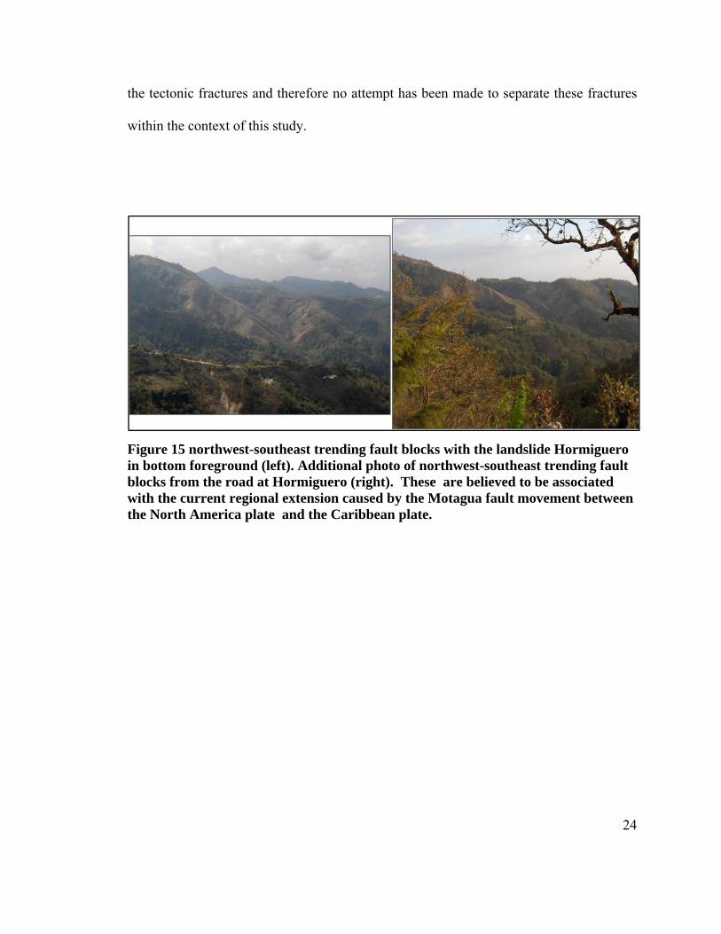
Figure 15 northwest-southeast trending fault blocks with the landslide Hormiguero in bottom foreground (left). Additional photo of northwest-southeast trending fault blocks from the road at Hormiguero (right). These are believed to be associated with the current regional extension caused by the Motagua fault movement between the North America plate and the Caribbean plate.
FHTthevre
In
co
th
ig
g
al
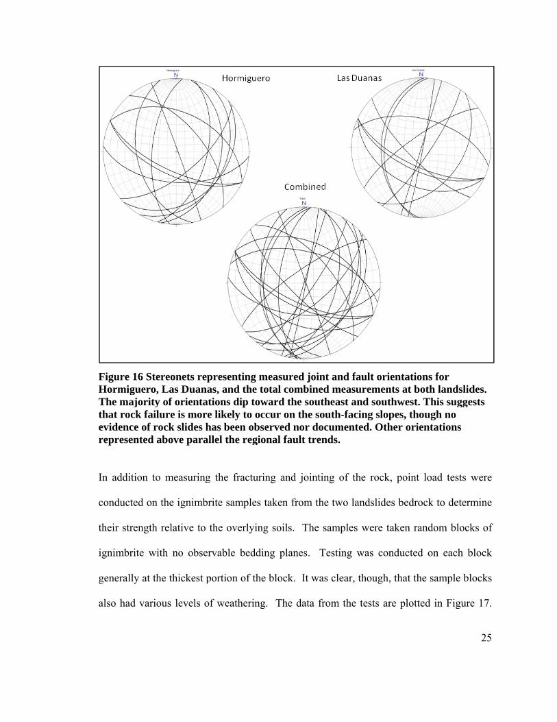
Figure 16 SteHormigueroThe majorityhat rock faividence of represented
n addition to
onducted on
heir strength
gnimbrite w
enerally at th
lso had vari
ereonets rep, Las Duanay of orientatlure is more
rock slides habove para
o measuring
n the ignimbr
h relative to
ith no obser
he thickest p
ous levels o
presenting mas, and the ttions dip towe likely to ohas been obsllel the regi
g the fractur
rite samples
the overlyin
rvable bedd
portion of th
of weathering
measured jototal combinward the soccur on the served nor onal fault tr
ring and join
s taken from
ng soils. Th
ding planes.
he block. It w
g. The data
oint and fauned measur
outheast andsouth-facin
documentedrends.
nting of the
the two lan
he samples w
Testing w
was clear, th
a from the te
ult orientatirements at bd southwestng slopes, thd. Other ori
e rock, point
ndslides bedr
were taken r
as conducte
hough, that th
ests are plot
ons for both landslit. This suggehough no ientations
t load tests
rock to deter
random bloc
ed on each b
he sample b
tted in Figur
25
des. ests
were
rmine
cks of
block
locks
re 17.
T
(1
as
sa
b
FH
W
la
w
or
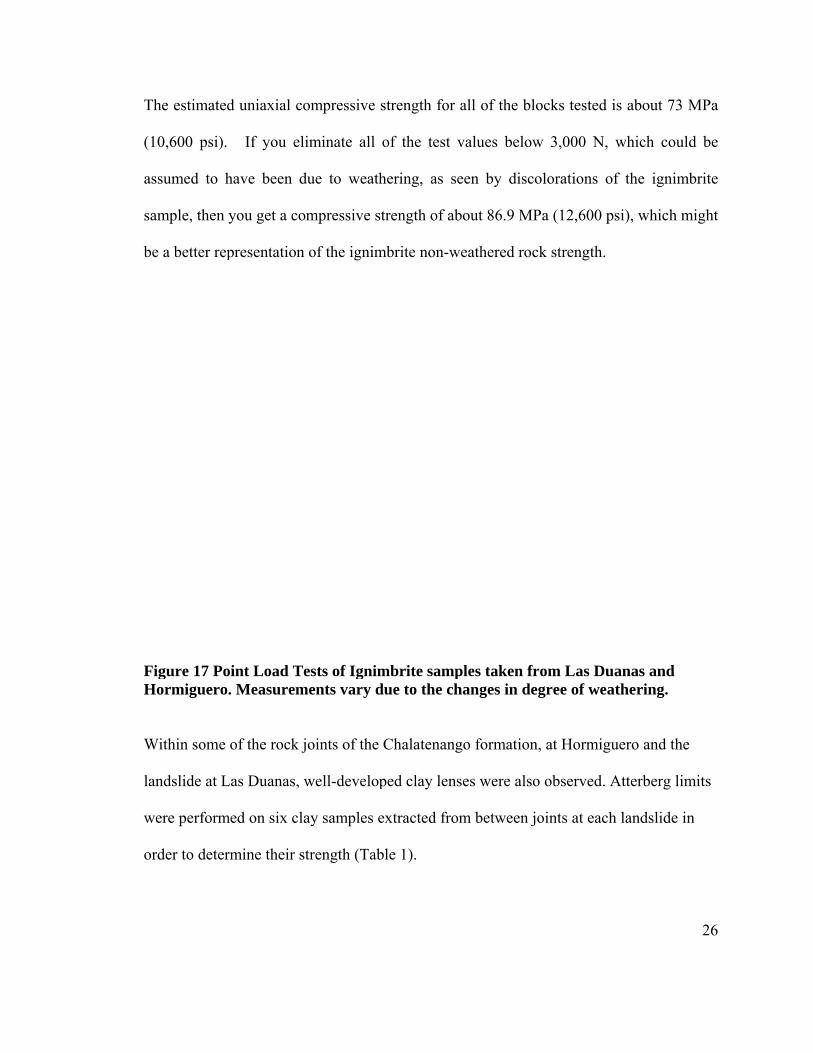
The estimated
10,600 psi).
ssumed to h
ample, then
e a better rep
Figure 17 PoHormiguero
Within some
andslide at L
were perform
rder to deter
d uniaxial co
If you el
have been d
you get a co
presentation
oint Load Te. Measurem
of the rock j
Las Duanas, w
med on six cla
rmine their s
ompressive
iminate all
due to weath
ompressive s
n of the ignim
ests of Ignimments vary d
joints of the
well-develop
ay samples e
strength (Tab
strength for
of the test
hering, as s
strength of ab
mbrite non-w
mbrite sampdue to the ch
Chalatenang
ped clay len
extracted fro
ble 1).
all of the bl
values below
een by disc
bout 86.9 M
weathered roc
ples taken fhanges in de
go formation
ses were als
om between j
locks tested
w 3,000 N,
colorations o
MPa (12,600 p
ck strength.
from Las Duegree of wea
n, at Hormig
o observed.
joints at eac
is about 73
which coul
of the ignim
psi), which m
uanas and athering.
guero and the
Atterberg lim
h landslide i
26
MPa
ld be
mbrite
might
e
mits
in
27
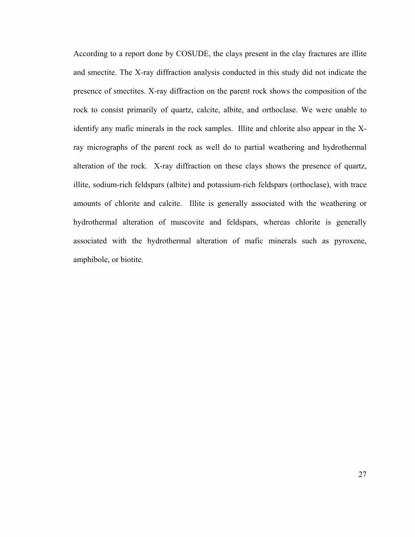
According to a report done by COSUDE, the clays present in the clay fractures are illite
and smectite. The X-ray diffraction analysis conducted in this study did not indicate the
presence of smectites. X-ray diffraction on the parent rock shows the composition of the
rock to consist primarily of quartz, calcite, albite, and orthoclase. We were unable to
identify any mafic minerals in the rock samples. Illite and chlorite also appear in the X-
ray micrographs of the parent rock as well do to partial weathering and hydrothermal
alteration of the rock. X-ray diffraction on these clays shows the presence of quartz,
illite, sodium-rich feldspars (albite) and potassium-rich feldspars (orthoclase), with trace
amounts of chlorite and calcite. Illite is generally associated with the weathering or
hydrothermal alteration of muscovite and feldspars, whereas chlorite is generally
associated with the hydrothermal alteration of mafic minerals such as pyroxene,
amphibole, or biotite.
28
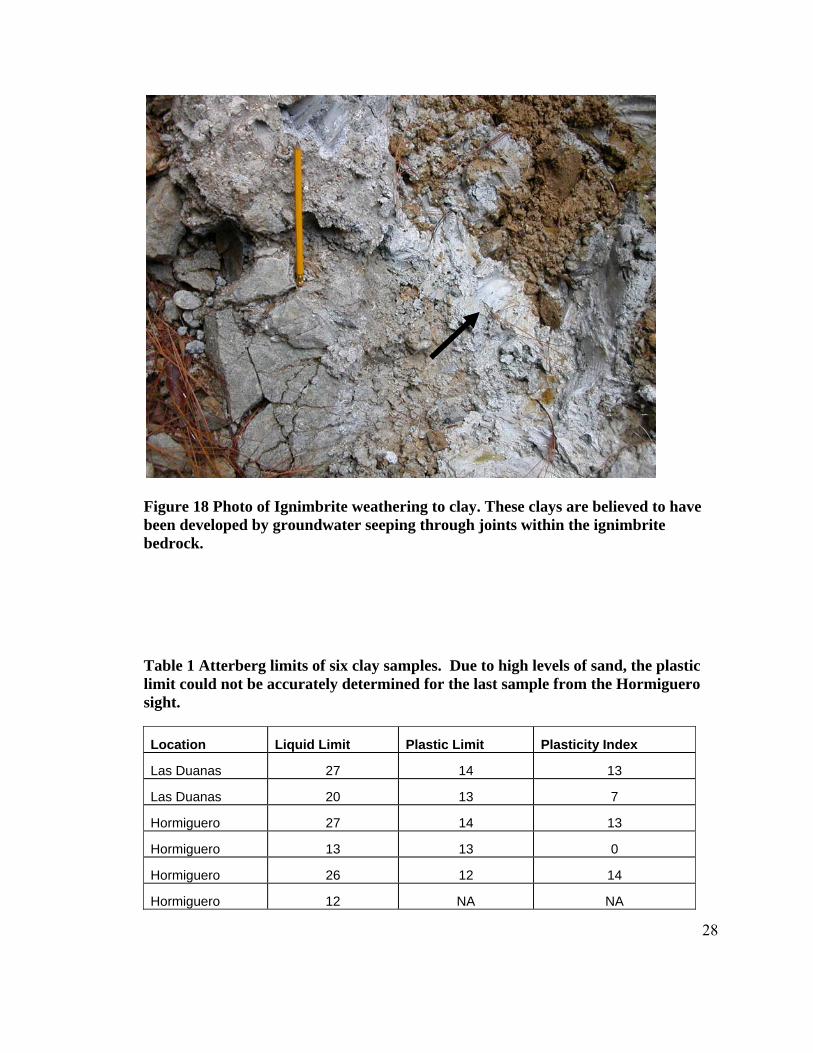
Figure 18 Photo of Ignimbrite weathering to clay. These clays are believed to have been developed by groundwater seeping through joints within the ignimbrite bedrock. Table 1 Atterberg limits of six clay samples. Due to high levels of sand, the plastic limit could not be accurately determined for the last sample from the Hormiguero sight.
Location Liquid Limit Plastic Limit Plasticity Index
Las Duanas 27 14 13
Las Duanas 20 13 7
Hormiguero 27 14 13
Hormiguero 13 13 0
Hormiguero 26 12 14
Hormiguero 12 NA NA
29
B. Geomorphological Analysis Slopes in both the Las Duanas landslide and Hormiguero are relatively steep. Average
slope angles for the Hormiguero and Las Duanas drainages are calculated to be between
40° and 50°, and 30° and 40° respectively (see Figure 20; Figure 22, Table 2 and Table
3).
Measured slopes for the two landslide basins range between 30 and 60 degrees. Failure
planes at Hormiguero were measured with a handheld inclinometer to be 45 degrees to
the west and 60 degrees to the East. Whereas slip surfaces, measured with a compass
inclinometer, show 55 degrees on the west facing slopes and 60 degrees on the east
facing slopes. Measurements from the handheld inclinometer at Las Duanas show a dip
angle between 45 and 50 degrees on the west facing slopes. A compass inclinometer
measurement of a slip surface, facing east, shows a slope angle of 56 degrees.
30
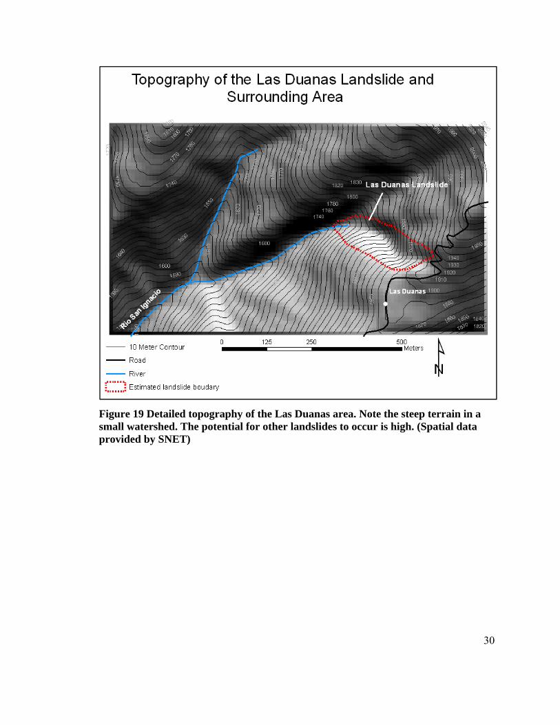
Figure 19 Detailed topography of the Las Duanas area. Note the steep terrain in a small watershed. The potential for other landslides to occur is high. (Spatial data provided by SNET)
31
Figure 20 Note the dominant slope angles within the landslide are between 30 and 50 degrees. The surrounding area has slopes that are predominantly between 30 and 50 degrees with a small area that measure more than 5 degrees. These steep slopes are expected to fail like the landslide at Las Duanas. (Spatial data provided by SNET).
Table 2 Slope Angle distribution for the Landslide at Las Duanas calculated from GIS data. The majority of the area within the landslide falls between 40 and 50 degrees.
18
39
48
4
05
10152025303540455055
10-20 20-30 30-40 40-50 50-60
Perc
ent A
rea
Slope Angle (degrees)
Las Duanas Slope Angle Distribution
32
Figure 21 Detailed topography of the Hormiguero landslide area show less steep terrain, in a small northeast-southwest trending drainage, than Las Duanas. (Spatial data provided by SNET)
33
Figure 22 Note that the range of slope angels within the landslide are between 20 and 40 degrees. (Spatial data provided by SNET).
Table 3 Slope Angle distribution for the Hormiguero landslide calculated from GIS data. Majority of the slope area for the landslide lies between 20 and 30 degrees.
7
38
55
0
10
20
30
40
50
60
1 2 3
Percen
t Area
Slope Angle (degrees)
Hormiguero Slope Angle Distribution
10 ‐ 20 30 - 4020- 30
34
VI.Residual Soil Formation
A. Soil Description
The soils of at higher elevations above La Palma and San Ignacio are classified as
latosols (Rico 1974). Latosols are characterized as (1) being rich in Fe, Al, Si; (2) formed
in tropical woodlands under very humid climates and with relatively high temperatures;
(3) shallow A horizons but thick B horizons (comprised of clay, sand, and sesquioxides
of Fe and Al); (4) red in color; and (5) low fertility due to the leaching of the minerals.
Latosols, even with seasonal rainfall changes and deep water tables, also appear to
maintain some water content all year round (Wesley 1973). The study area surrounding
the Las Duanas landslide and Hormiguero, soils are approximately 2 to 3 meters thick
and directly overlie the Chalatenango ignimbrite. We see a distinct unconformity
between the low lying ignimbrite and the soil layer (Figure 23) where there is an absence
of a rock to C horizon transition (Figure 23).
35
Figure 23 Photo of the soil rock unconformity. Note the sharp unconformity between the regolith and the bedrock. Rock blocks spall/pluck from the rock mass once exposed.
36
Figure 24 Photo taken by Dr. Stanley J. Vitton of soil profile of a latosols from road cut. Shows red color, thin A horizon and thicker B horizon.
B. Climate El Salvador, as with the rest of Central America, has a wet season and a dry season. The
dry season, from November to April, is characterized by little rainfall, averaging 123mm
in the study region, and the highest temperatures of the year (Figure 25). The wet season,
from May to October, is characterized by cooler temperatures and high rainfall, averaging
1702mm in the study region (Figure 25).
The Hormiguero and the Las Duanas landslides are located between two rain gauge
stations which are monitored by SNET. The highest rain gauge is in a village called Las
Pilas, approximately 4 kilometers northeast of the Las Duanas landslide and
approximately seven kilometers northeast of the Hormiguero landslide. The average
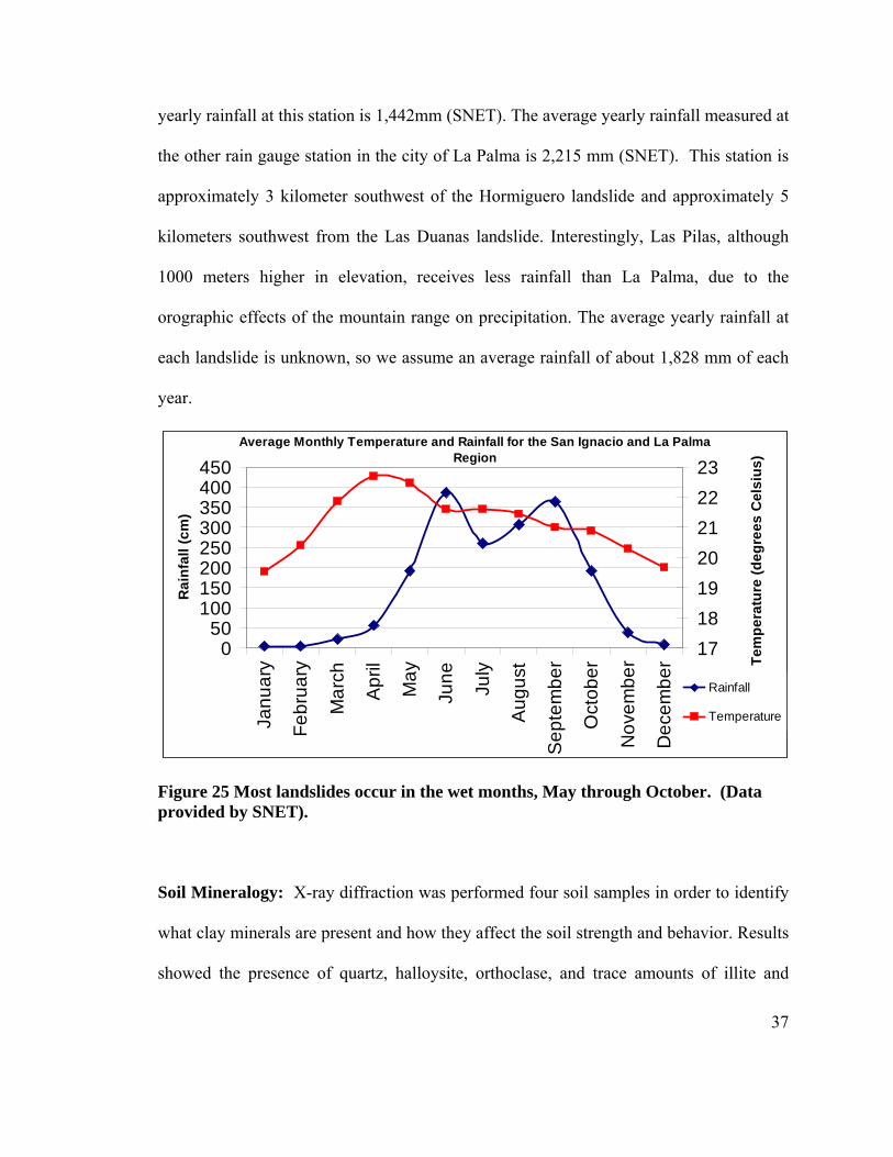
37
yearly rainfall at this station is 1,442mm (SNET). The average yearly rainfall measured at
the other rain gauge station in the city of La Palma is 2,215 mm (SNET). This station is
approximately 3 kilometer southwest of the Hormiguero landslide and approximately 5
kilometers southwest from the Las Duanas landslide. Interestingly, Las Pilas, although
1000 meters higher in elevation, receives less rainfall than La Palma, due to the
orographic effects of the mountain range on precipitation. The average yearly rainfall at
each landslide is unknown, so we assume an average rainfall of about 1,828 mm of each
year.
Figure 25 Most landslides occur in the wet months, May through October. (Data provided by SNET).
Soil Mineralogy: X-ray diffraction was performed four soil samples in order to identify
what clay minerals are present and how they affect the soil strength and behavior. Results
showed the presence of quartz, halloysite, orthoclase, and trace amounts of illite and
Average Monthly Temperature and Rainfall for the San Ignacio and La Palma Region
050
100150200250300350400450
Janu
ary
Febr
uary
Mar
ch
Apr
il
May
June July
Aug
ust
Sep
tem
ber
Oct
ober
Nov
embe
r
Dec
embe
r
Rai
nfal
l (cm
)
17181920212223
Tem
pera
ture
(deg
rees
Cel
sius
)
Rainfall
Temperature
38
albite. Scanning electron microscopy performed on a sample at a depth of 66 centimeters
indicates supports the x-ray evidence for the presence of halloysite. Furthermore, the
SEM data shows the presence of allophone and imogolite which are also associated with
the weathering of latosols. Kaolinite was not detected in the samples, which might
constrain the age of these soils.
Moisture Content: Moisture contents were measured on 37 soil samples at 19 different
depths at the Las Duanas site (Figure 26). Moisture content values range between 20%
and 46% and increase with depth. Moisture contents within the first 60 centimeters,
though, show the highest moisture contents; ranging from 38% to 46%.
Figure 26 Moisture content of soil at Las Duanas at various depths. Moisture content increases with depth. Higher moisture contents within the first 60 centimeters is attributed to the advanced degree of weathering of the soils to increased clay content.
050
100150200250300
0 10 20 30 40 50
Dep
th (c
m)
Moisture Content (%)
39
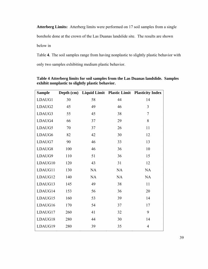
Atterberg Limits: Atterberg limits were performed on 17 soil samples from a single
borehole done at the crown of the Las Duanas landslide site. The results are shown
below in
Table 4. The soil samples range from having nonplastic to slightly plastic behavior with
only two samples exhibiting medium plastic behavior.
Table 4 Atterberg limits for soil samples from the Las Duanas landslide. Samples exhibit nonplastic to slightly plastic behavior. Sample Depth (cm) Liquid Limit Plastic Limit Plasticity Index
LDAUG1 30 58 44 14
LDAUG2 45 49 46 3
LDAUG3 55 45 38 7
LDAUG4 66 37 29 8
LDAUG5 70 37 26 11
LDAUG6 82 42 30 12
LDAUG7 90 46 33 13
LDAUG8 100 46 36 10
LDAUG9 110 51 36 15
LDAUG10 120 43 31 12
LDAUG11 130 NA NA NA
LDAUG12 140 NA NA NA
LDAUG13 145 49 38 11
LDAUG14 153 56 36 20
LDAUG15 160 53 39 14
LDAUG16 170 54 37 17
LDAUG17 260 41 32 9
LDAUG18 280 44 30 14
LDAUG19 280 39 35 4
40
Shear Strength: Surface torr vane measurements averaged about 1.0 Kg/cm2 (2,000
lbs/ft2) with a high value of 1.25 Kg/cm2 (2,500 lbs/ft2) Torr vane measurements taken
by Wallace 1973 measures similar soils (latosols, containing allophone) found that the
soils generally range from 800-1200 lbs/ft2, though some samples reached as high as
2500 lbs/ft2.
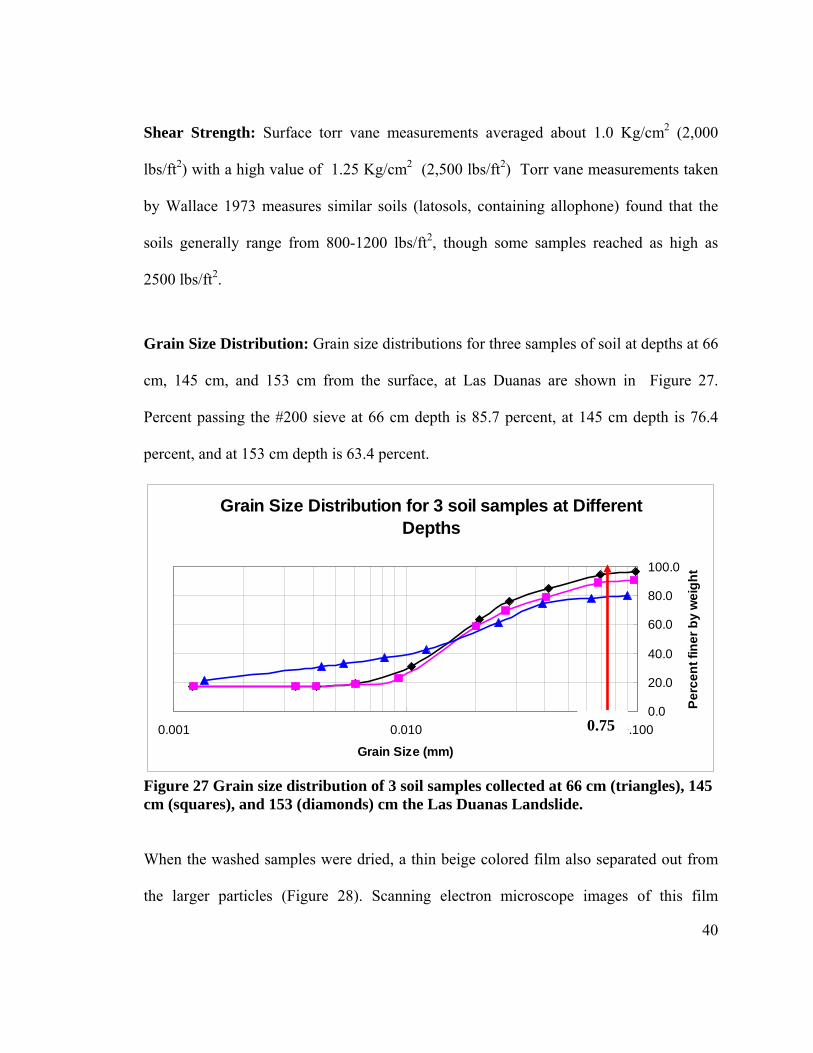
Grain Size Distribution: Grain size distributions for three samples of soil at depths at 66
cm, 145 cm, and 153 cm from the surface, at Las Duanas are shown in Figure 27.
Percent passing the #200 sieve at 66 cm depth is 85.7 percent, at 145 cm depth is 76.4
percent, and at 153 cm depth is 63.4 percent.
Figure 27 Grain size distribution of 3 soil samples collected at 66 cm (triangles), 145 cm (squares), and 153 (diamonds) cm the Las Duanas Landslide.
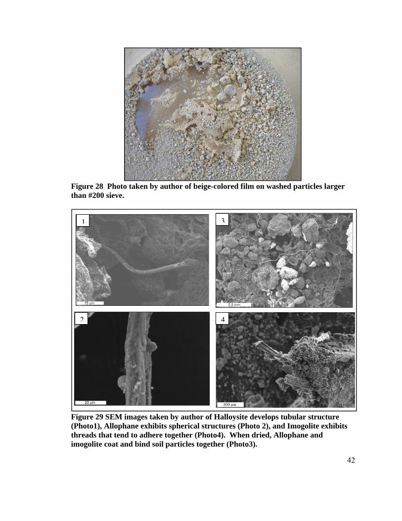
When the washed samples were dried, a thin beige colored film also separated out from
the larger particles (Figure 28). Scanning electron microscope images of this film
Grain Size Distribution for 3 soil samples at Different Depths
0.0
20.0
40.0
60.0
80.0
100.0
0.001 0.010 0.100
Grain Size (mm)
Perc
ent f
iner
by
wei
ght
0.75

41
appeared to indicate a mixture of allophane, imogolite and possible halloysite (Figure
29). Research has indicated that in scanning electron microscope images, allophone
appears as spherules or clusters of spherules around 50Å that possess strong coulombic
attractions which in turn resist shearing, Imogolite appears as solid threads that
sometimes adhere together, and halloysite appears as tubes oriented parallel to each other
when wet but appear entangle when dried (Rao 1995, Rouse 1986). These structures
haven’t been confirmed by TEM and therefore we can only suggest the presence of these
minerals from the SEM micrographs alone. Past studies have shown that soils developing
from andesitic to rhyolitic ashes and in warm, wet climates can generate halloysite, the
non-crystalline aluminosilicate, Allophane, and the paracrystalline aluminosilicate,
Imogolite. Deflocculation of soils rich in allophane and imogolite is difficult because of
the highly adhesive behavior of these clays to each other and the particles which they
coat (Rouse 1986). This binding behavior of allophone and imogolite has been shown in
previous studies to under estimate the fine-grained proportion of grain-size analyses
(Rouse, 1986).
42
Figure 28 Photo taken by author of beige-colored film on washed particles larger than #200 sieve.
Figure 29 SEM images taken by author of Halloysite develops tubular structure (Photo1), Allophane exhibits spherical structures (Photo 2), and Imogolite exhibits threads that tend to adhere together (Photo4). When dried, Allophane and imogolite coat and bind soil particles together (Photo3).
2
1 3
4
43
VII.Slope Stability Analysis
A. Slope Stability Parameters
Although there has been extensive research into the stability of slopes, there still exist
many contradictory findings in the literature, especially when dealing with tropical
residual soils. Recognizing this, Rahardjo et al. (2007) conducted a parametric study to
determine the relative importance of each controlling parameter. The parameters studied
included (1) soil properties, (2) rainfall intensity, (3) initial depth of water table and (4)
slope geometry. Their analysis assigned the factor of safety (F) as the dependent variable
and the remaining factors as the independent variables. A significant finding of this
study coupled with an earlier study by the same lead author (Rahardjo et al. (2001) is that
for slopes with permeabilities lower than 10-6 m/s their stability is not dependent on
rainfall intensity. For slopes with higher permeability, rainfall intensity becomes
significant, i.e., the stability of the slope is greatly affected by the short-duration high
intensity rainfalls. Although slopes with high slope angles and a shallower initial depth
of water table combine to provide the worst combination of factors for failure and are
more likely to fail due to a rain event, the actual failure conditions are very much dictated
by the rainfall intensity and the properties of the soil in the slope. Therefore, according to
Rahardjo (2007), “when dealing with rainfall-induced slope failures, emphasis should be
on the rainfall intensity and soil properties, particularly the saturated coefficient of
permeability.”
44
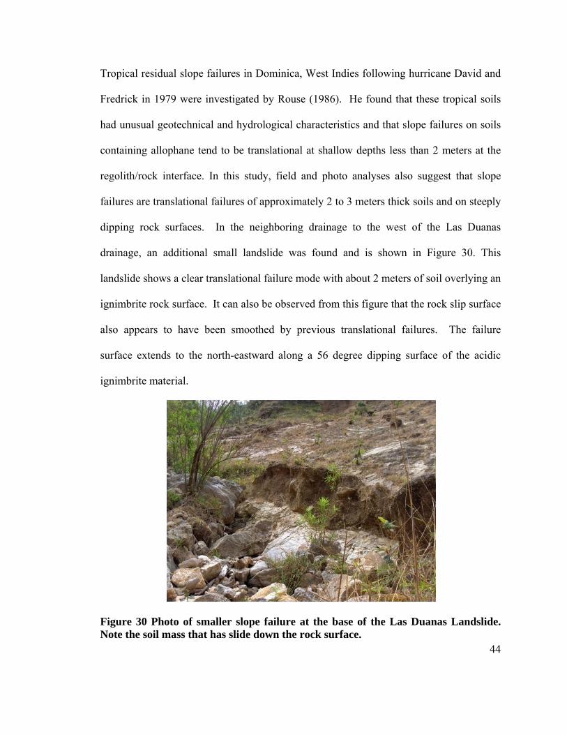
Tropical residual slope failures in Dominica, West Indies following hurricane David and
Fredrick in 1979 were investigated by Rouse (1986). He found that these tropical soils
had unusual geotechnical and hydrological characteristics and that slope failures on soils
containing allophane tend to be translational at shallow depths less than 2 meters at the
regolith/rock interface. In this study, field and photo analyses also suggest that slope
failures are translational failures of approximately 2 to 3 meters thick soils and on steeply
dipping rock surfaces. In the neighboring drainage to the west of the Las Duanas
drainage, an additional small landslide was found and is shown in Figure 30. This
landslide shows a clear translational failure mode with about 2 meters of soil overlying an
ignimbrite rock surface. It can also be observed from this figure that the rock slip surface
also appears to have been smoothed by previous translational failures. The failure
surface extends to the north-eastward along a 56 degree dipping surface of the acidic
ignimbrite material.
Figure 30 Photo of smaller slope failure at the base of the Las Duanas Landslide. Note the soil mass that has slide down the rock surface.
45
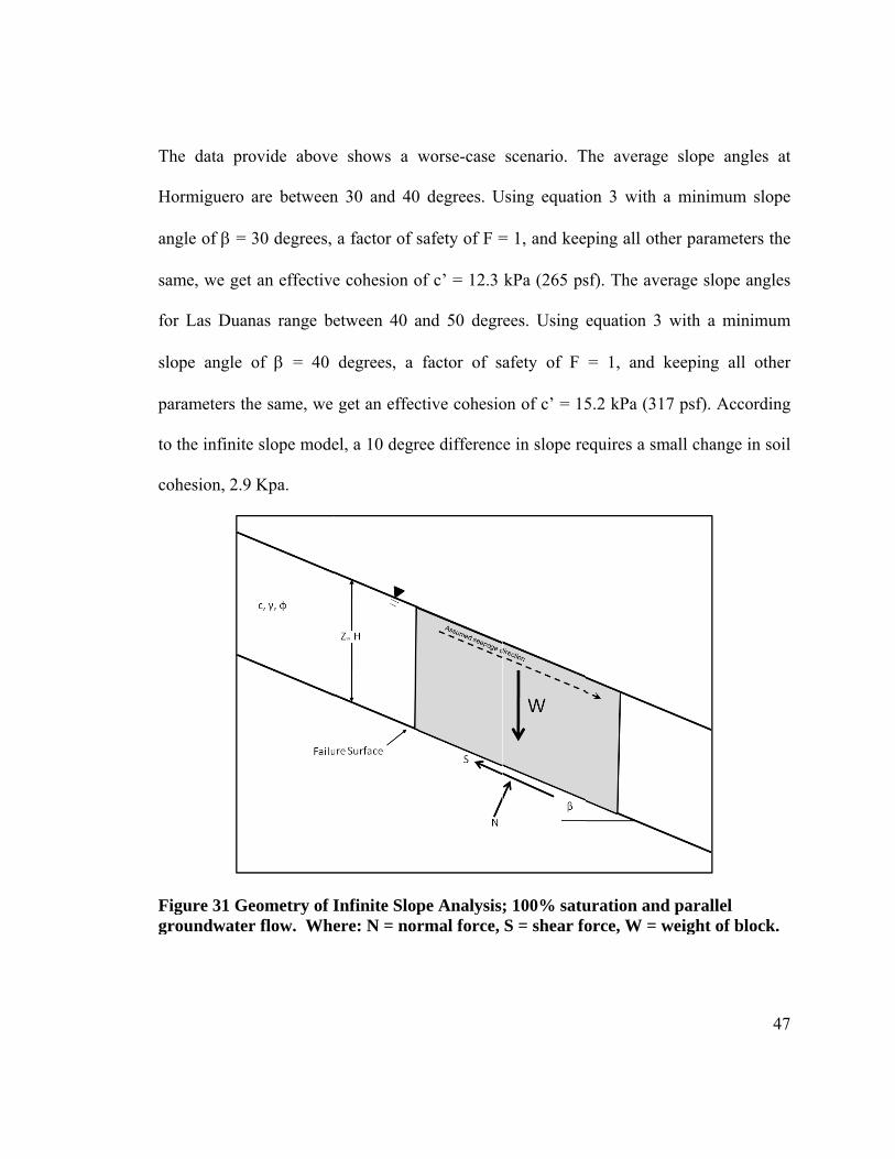
B. Infinite Slope Analysis
According to Wallace (1973) the undrained shear strength of the residual soils formed
from volcanic ashes in Java, Indonesia ranged from 38 to 120 kPa (800 to 2,500 psf).
The undrained shear strength measurements in this study averaged about 96 kPa,
approximately in the mid-range of Wallace’s data. A simple infinite slope analysis (see
Figure 31) was used in the analysis of the landslides. Using the undrained shear strength
(total stress analysis), the factor of safety of the slope can be determined from Equation
(1) (Duncan, et al 2005). Assuming a unit soil weight γ = 18.8 kN/m3, a peak slope angle
of β = 60°, a friction angle of φ = 38 degrees and a soil thickness of z = 2 meters. The
factor of safety is calculated to be 2.5, which is significant given the steepness of the
slope, i.e., β = 60°. This helps explain the high vertical cut slopes along many of the
roads and highways in El Salvador and provides insight into the high slope stability
within the region. For example, using Terzaghi’s (1943) equation for the factor of safety
of a vertical wall (Equation 2), the height of the wall can be determined given a factor of
safety equal to one. Using the undrained soil shear strength c = 96 kPa, the factor of
safety F=1, and a soil unit weight γ = 18.8 kN/m3 a vertical wall could stand
approximately 20 m.
(1)
46
(2)
As discussed above, significant landslides occur during intense rainfall periods
particularly during hurricanes. Rouse (1986) conducted triaxial tests on the Dominica
West Indies volcanic soil determining the following average soil strength values:
c’ = 15.3 kPa (320 psf)
φ’ = 38°
The infinite slope equation for an effective stress analysis is given in Equation 3 while
the pore pressure parameter (ru) is given in Equation 4 (Duncan, et al 2005).
(3)
(4)
The most probable critical flow condition in the slopes would be parallel to the slope
given the impermeability of the underlying ignimbrite rock. Assuming 100% saturation
and parallel flow to the slope, a soil unit weight γ = 18.8 kN/m3, the unit weight of water
γw = 1000 Kg/m3, β = 60° slope and a soil thickness of z = 2 m, the factor of safety of the
slope drops to 0.98 indicating that these conditions would lead to failure during a
rainstorm that is intense enough to fully saturate the slope and cause parallel flow in the
slope.
T
H
an
sa
fo
sl
p
to
co
Fg
The data pro
Hormiguero
ngle of β =
ame, we get
or Las Duan
lope angle
arameters th
o the infinite
ohesion, 2.9
Figure 31 Geroundwater
ovide above
are between
30 degrees,
t an effective
nas range be
of β = 40
he same, we
e slope mode
Kpa.
eometry of Ir flow. Whe
e shows a w
n 30 and 40
a factor of s
e cohesion o
etween 40 a
degrees, a
get an effec
el, a 10 degr
Infinite Slopere: N = nor
worse-case
0 degrees. U
safety of F =
of c’ = 12.3
and 50 degr
factor of s
ctive cohesio
ree differenc
pe Analysisrmal force,
scenario. T
Using equatio
= 1, and kee
kPa (265 ps
rees. Using
afety of F
on of c’ = 15
ce in slope re
; 100% satuS = shear fo
The average
on 3 with a
ping all othe
sf). The aver
equation 3 w
= 1, and k
5.2 kPa (317
equires a sm
uration andorce, W = w
slope angl
a minimum
er parameter
rage slope a
with a mini
keeping all
7 psf). Acco
mall change in
parallel weight of blo
47
les at
slope
rs the
angles
imum
other
rding
n soil
ock.
48
C. Allophane, Halloysite, and Imogolite
Allophanes have unusually high moisture contents (100-150%) which are believed to be
an indication of high void ratios and high porosities (Wallace 1973). This study, because
of moisture loss between the time of sample collection and time of testing, found lower
moisture contents of about 35% (Figure 26). Wesley (1973) and Rouse (1986) identify
one of the indicators for the presence allophone is the location of the soils on the
Cassagrande plasticity chart. Soils containing allophane tend to plot below the A-line, in
the silt range (Rouse 1986). According to Rao 1995, liquid limits for allophones range
from 50 to 100%. This study obtained lower values which may be due to the amount of
allophone present in the soil and the possibility that the soils did not fully saturate after
being re-wetted. When air-dried, allophones become non-plastic and do not regain
plasticity when they re-wetted (Wallace 1973).
The soils in this study are believed to have formed from a relatively young, partially
welded tuff. The development of allophone, halloysite, and imogolite, occurs at early
stages of soil development from the dissolution of a combination of pumice, quartz,
micas, and feldspars contained within ash-rich deposits, such as tuffs and ignimbrites
(Abayneh 2006). Further weathering of these minerals precipitates secondary clay
minerals, such as kaolinite (Abayneh 2006).
Allophane and imogolite are generally present as a coating on soil particles and in a gel-
like state. Documented strength properties of allophone, imogolite, and halloysite are
49
high. As long as allophonic soils stay wet, they maintain thixotropy and their sticky
consistence (Jongsman 2000 referenced from Shoji 1993). When dried, the gel-like
allophone and imogolite coat the soil particles to form stable aggregates in a “coarse open
skeleton” that therefore leads to cementation of the originally loose, sandy soil
(Jongsman 2000; Kubota 1976; Wadentin & Maeda 1980; Wada 1989; Wallace 1973).
This aggregation is generally observed at the interface where the soils are dried and re-
wetted with the changes in seasonal rainfall (Rouse 1986). In addition, the gel-like
hydrated allophones, still present between voids, support a portion of the load at the
contacts between coarse particles (Wallace 1973). This proportion of load carrying
ability by allophone in its gel state is believed to be low (Wallace 1973).
Wesley (1977 and 1973) point out that the high shear strengths of allophone-bearing
latosols are associated with high moisture contents and lower degrees of weathering. The
shear strength of allophonic soils is not affected by different plasticity indices (Rao
1995). Rouse 1986 measured the residual strength of allophonic soils and found using
direct shear testing the residual frictional strength to be 30-38 degrees. This behavior,
according to Wallace 1973, is similar to the behavior over-consolidated clays when tested
with a direct shear box. With the ring shear test, Rouse 1986 found friction strength to be
between 25-34 degrees. Rouse also points out that these values vary by 0.6 degrees with
samples that have been previously dried.
50
The results of residual and peak strength tests carried out by Wesley (1977) on soils
containing halloysites and soils with allophones show slightly different results. His study
showed that residual strengths of soils with halloysite are lower than peak strength due to
particle re-orientation. Residual strengths of soils containing allophone, on the other
hand, showed “marginally’ lower residual strengths than peak strengths. This, according
to Wesley 1977, occurs because the allophone gel does not contain particles that would
otherwise re-orient toward a preferred direction. Furthermore, strength reduction does not
occur with displacement along a shear plane (Wesley 1977). The soils in the Hormiguero
and Las Duanas sites are believed to behave similarly to these end-members since they
contain both minerals.
D. Hydrology
According to the USGS Open File Report 01-444, Hormiguero was caused by Hurricane
Mitch (USGS 2001). This implies that under normal climatic conditions, the slopes are
relatively stable and well drained. When high rainfall over short periods of time, like
hurricanes and tropical depressions, occur the soil saturates and there is an increase in
overburden stress.
Soils containing allophone, imogolite, and halloysite have been documented as being
more permeable than sedimentary soils, even though they have higher clay fractions
(Wesley 1977). Rouse 1986 measures soil permeability to be 5-20 mm/hr, which decrease
with depth to 2-5 mm/hr at the soil/rock interface. Wallace 1973 also mentions that upon
51
drying, permeability is increased. This may be an important control for the high drainage
capabilities of the soil layers (O and A horizons) above the AB interface and contribute to
the rapid downslope drainage of groundwater and difficulty for these soils to saturate.
Concentrated layers of precipitated allophone at the AB interface and the soil/rock
interface have an interesting affect on the groundwater flow as well. The AB layer
prevents the water from infiltrating to deeper levels which therefore generates overland
flow and high parallel flow on steep slopes (Rouse 1986). This low permeability also
prevents the soil at deeper levels from becoming saturated, though the soil/rock interface
is believed to be saturated all year round (Rouse 1986). As mentioned in the “Soils”
section of this report, the soil has a higher moisture content within the first 60
centimeters. This is probably due to the buildup of groundwater above the AB layer and
more importantly to the higher percentage of secondary clay minerals such as kaolinite.
In addition to the high permeability of the soils due to the effects of allophane and
imogolite, the rock joints within the underlying ignimbrite play a significant role in the
groundwater hydrology. Since the streams within the drainages flow all year and exit
from the rock layers, water must be permeating through the rock. The rock is very hard,
as mentioned previously, and therefore the water must be migrating through the rock
fractures. These additional conduits increase the ability for water to drain through the
system and keep the soils from over-saturating under normal rain conditions.
52
VIII.Discussion
A. Tectonic Effects The Central American Highlands and the valleys within them are tectonically controlled.
The older northeast-southwest extensional event, caused by either the uplift of the Central
American Highlands (Chortis Block) or by plate boundary stresses, that took place after
the deposition of the late-miocene ignimbrite created the larger valleys such as the
valleys where the Rio San Ignacio and the Rio La Palma rivers flow through (Figure 32),
throughout the northern mountains of El Salvador. These older faults have since been
truncated by northwest-southeast extensional fault from North America - Caribbean plate
boundary stresses. It is within this system of smaller and less developed faults that small
valleys form. On the north-facing valleys of this system, landslides form. These valleys
are characterized by rapidly developed soils with thicknesses between 2 and 3 meters
standing on tectonically controlled slopes of between 20 and 50 degrees. Slope steepness
within the region is controlled by the amount of fault displacement of the half-grabens.
Since these slopes are steep, as high as 65 degrees, it can be assumed that the amount of
displacement is relatively large. As displacement increases, half graben blocks will
steepen on the paleosurface and the fault boundaries will flatten out. Since northeast-
southwest half-grabens within the region are steeply dipping on the paleosurface to the
northwest (Figure 32) we see more landslides.
53
B. Structural Controls Joints are very important in a slope stability analysis because they can form planes of
weakness and control the infiltration of water (Wohletz 2006). Rock failures do not
appear to be the causes of the slope failures within the northern mountains of El Salvador.
Field investigations did not encounter larger rock block wedges sliding along rock
surfaces. Moreover, photos (Figure 12, Figure 13) of the landslides show that the Las
Duanas and Hormiguero drainages are too narrow for block sliding to occur. The high
strength values, 87 MPa (12,600 psi), for the rock indicate that the rocks are dense, very
resistant and can stand vertically without loss of strength. In addition stereonet plots in
Figure 16 show a high concentration of joints dipping steeply toward the south/southeast
and into the slopes and therefore do not extend out of the more shallow-dipping southern
slopes. Although the intersections of many fractures may create potential failure
blocksFigure 16, field observations do not indicate rock failure as the cause of the
landslides in the region. Nonetheless, rock blocks are present in the drainages. These
blocks are believed to have been transported by plucking or spalling of individual blocks,
along what might be steeply dipping cooling fractures or different depositional surfaces
from the various stages of volcanic eruption, exposed after the overlying soil has eroded
away. The importance of the fractures in this region, though, lies in the groundwater flow
and its ability to drain quickly.
The clays present in between rock joints are believed to have developed from the
wreathing of the ignimbrites by the infiltration of groundwater through the system of
joints. Clay thicknesses vary due to joint spacing and the increased surface area of
54
fracture zones of faults. Calculated plasticity indices indicate that the clays in these sites
are slightly plastic. The sand sized particles are believed to have been the causes for the
lower than expected liquid limit, plastic limit, and plasticity index values.
The clay samples from these lenses within the ignimbrite analyzed by X-ray diffraction
spectrometry showed the presence of illite, chlorite, and quartz. The importance of illite
and chlorite are that they are non-expansive clays. No expansive clays were observed in
the X-ray diffraction patterns which may be the result of low concentrations of expansive
clays, such as smectites, within these layers or more likely the absence of expansive
clays. This implies that the clays within the fractures do not add any pushing forces
against the fracture walls, due to swelling, which could lead to rock failures. Although
the clay within the rock joints currently does not seem to decrease the slope stability, the
continued infiltration of water through these allows for continued weathering of the rock
surfaces clay and this degradation may cause slope failure.
C. Weathering Controls Soil depth and type are affected by several factors including climate and parent rock
mineralogy. From field observations it is believed that the soil depth and formation has
been controlled by the deposition of poorly welded tuff material blanketing the late
miocene-aged ignimbrite sometime after the tectonic activity subsided. There does not
appear to be a well transition from the C horizon to the solid, unaltered rock. In addition,
once the soil detritus has washed away from the slope scarps a hard, unaltered rock
surface is exposed (Figure 30). Subsequent translational slope failures show the soil
55
masses slide over this surface (Figure 30). This exposed rock shows an uneven pitted
surface that appears to have been once the paleosurface. An additional control on the
stability of the slopes is the buttressing effects that this deposited partially welded tuff
layer created when blanketing the banks of the drainages (Figure 32). The downslope
forces on the tuff are counteracted by the downslope forces on the other side of the
drainages. As the streams cut through the tuff material at the base of the slopes, the
counteracting buttressing forces weaken the slope stability of the system. Further
investigations are needed to more accurately classify these soils and to determine the
parent material; whether it is formed from the late-miocene-aged Chalatenango formation
or from a more recently deposited partially-welded tuff. This anomaly at this point can
only be explained by the deposition of younger poorly-welded volcanic ash overtop the
older ignimbrite of the Chalatenango formation.
The older, more densely welded, bedrock has acted as an aquitard with some drainage
occurring within the fractures of the rock. Meteoric water has accumulated at this contact
and has significantly weathered the overlying ash to soil. Fieldes (1955) demonstrates
that the presence of allophone in the B horizon indicates a young state of the soil
formation process. The following stages in the evolution of these soils are: the presence
of allophone in the AB interface; the presence of allophone in the A horizon; the
introduction of meta-halloysite; and finally the presence of kaolinite (Fieldes 1955).
Although the extent of weathering has not been determined from the mineralogy, we
believe that these soils represent a more advanced stage of soil development.
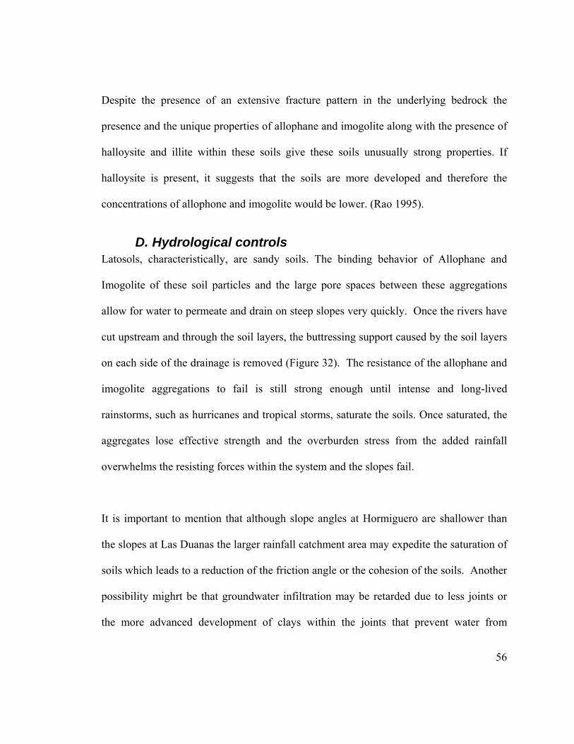
56
Despite the presence of an extensive fracture pattern in the underlying bedrock the
presence and the unique properties of allophane and imogolite along with the presence of
halloysite and illite within these soils give these soils unusually strong properties. If
halloysite is present, it suggests that the soils are more developed and therefore the
concentrations of allophone and imogolite would be lower. (Rao 1995).
D. Hydrological controls Latosols, characteristically, are sandy soils. The binding behavior of Allophane and
Imogolite of these soil particles and the large pore spaces between these aggregations
allow for water to permeate and drain on steep slopes very quickly. Once the rivers have
cut upstream and through the soil layers, the buttressing support caused by the soil layers
on each side of the drainage is removed (Figure 32). The resistance of the allophane and
imogolite aggregations to fail is still strong enough until intense and long-lived
rainstorms, such as hurricanes and tropical storms, saturate the soils. Once saturated, the
aggregates lose effective strength and the overburden stress from the added rainfall
overwhelms the resisting forces within the system and the slopes fail.
It is important to mention that although slope angles at Hormiguero are shallower than
the slopes at Las Duanas the larger rainfall catchment area may expedite the saturation of
soils which leads to a reduction of the friction angle or the cohesion of the soils. Another
possibility mighrt be that groundwater infiltration may be retarded due to less joints or
the more advanced development of clays within the joints that prevent water from
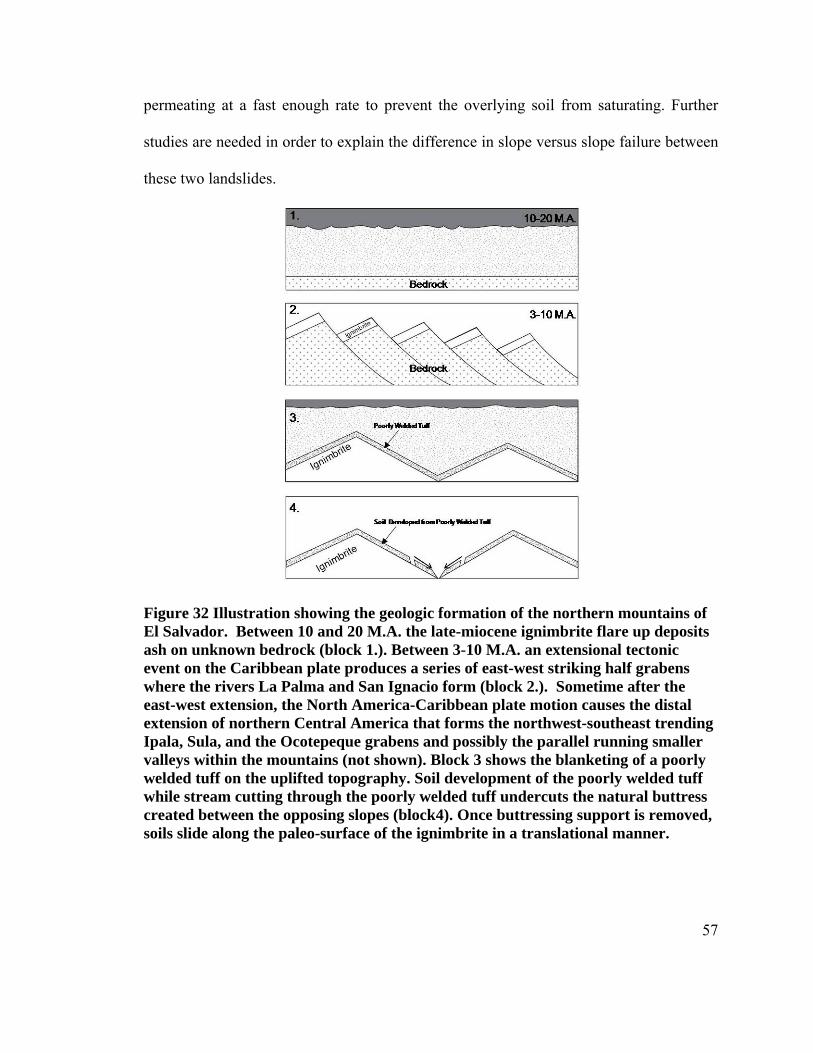
57
permeating at a fast enough rate to prevent the overlying soil from saturating. Further
studies are needed in order to explain the difference in slope versus slope failure between
these two landslides.
Figure 32 Illustration showing the geologic formation of the northern mountains of El Salvador. Between 10 and 20 M.A. the late-miocene ignimbrite flare up deposits ash on unknown bedrock (block 1.). Between 3-10 M.A. an extensional tectonic event on the Caribbean plate produces a series of east-west striking half grabens where the rivers La Palma and San Ignacio form (block 2.). Sometime after the east-west extension, the North America-Caribbean plate motion causes the distal extension of northern Central America that forms the northwest-southeast trending Ipala, Sula, and the Ocotepeque grabens and possibly the parallel running smaller valleys within the mountains (not shown). Block 3 shows the blanketing of a poorly welded tuff on the uplifted topography. Soil development of the poorly welded tuff while stream cutting through the poorly welded tuff undercuts the natural buttress created between the opposing slopes (block4). Once buttressing support is removed, soils slide along the paleo-surface of the ignimbrite in a translational manner.
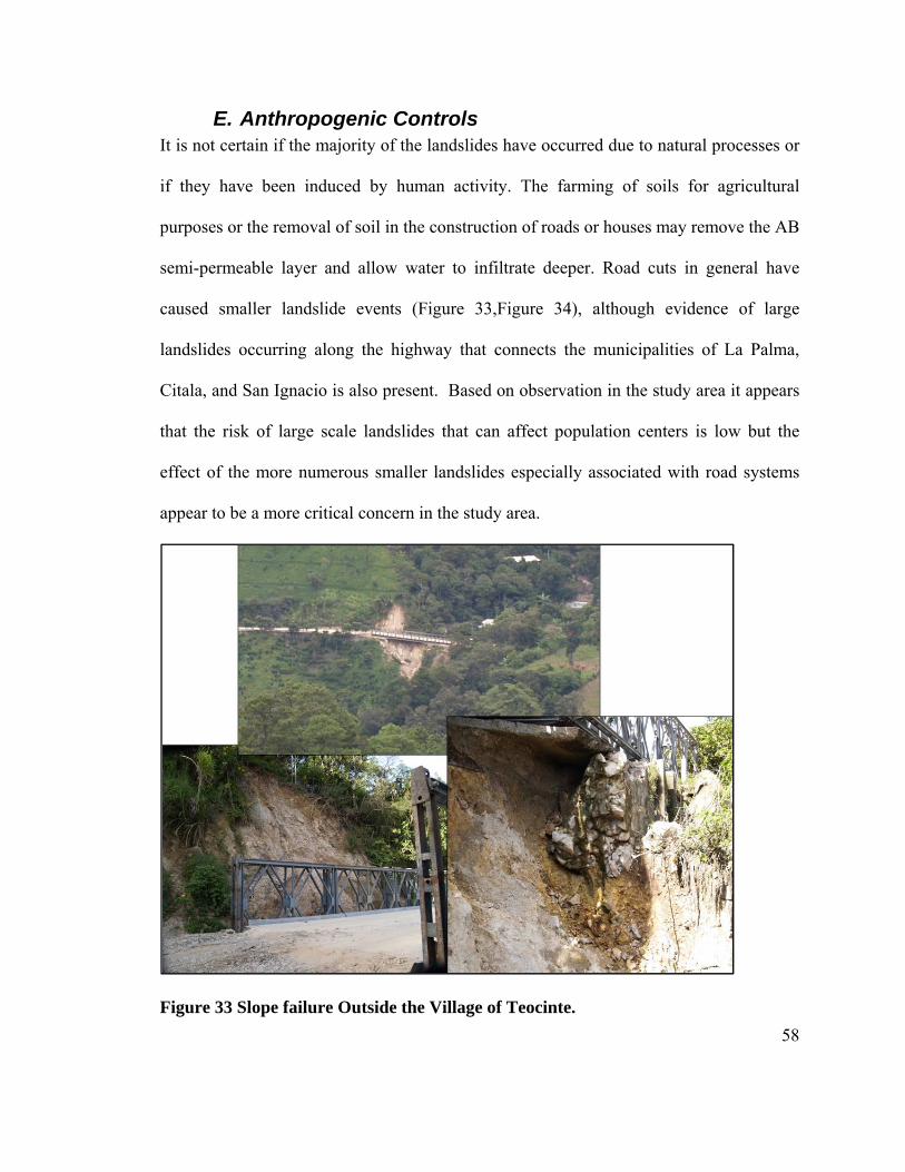
58
E. Anthropogenic Controls It is not certain if the majority of the landslides have occurred due to natural processes or
if they have been induced by human activity. The farming of soils for agricultural
purposes or the removal of soil in the construction of roads or houses may remove the AB
semi-permeable layer and allow water to infiltrate deeper. Road cuts in general have
caused smaller landslide events (Figure 33,Figure 34), although evidence of large
landslides occurring along the highway that connects the municipalities of La Palma,
Citala, and San Ignacio is also present. Based on observation in the study area it appears
that the risk of large scale landslides that can affect population centers is low but the
effect of the more numerous smaller landslides especially associated with road systems
appear to be a more critical concern in the study area.
Figure 33 Slope failure Outside the Village of Teocinte.
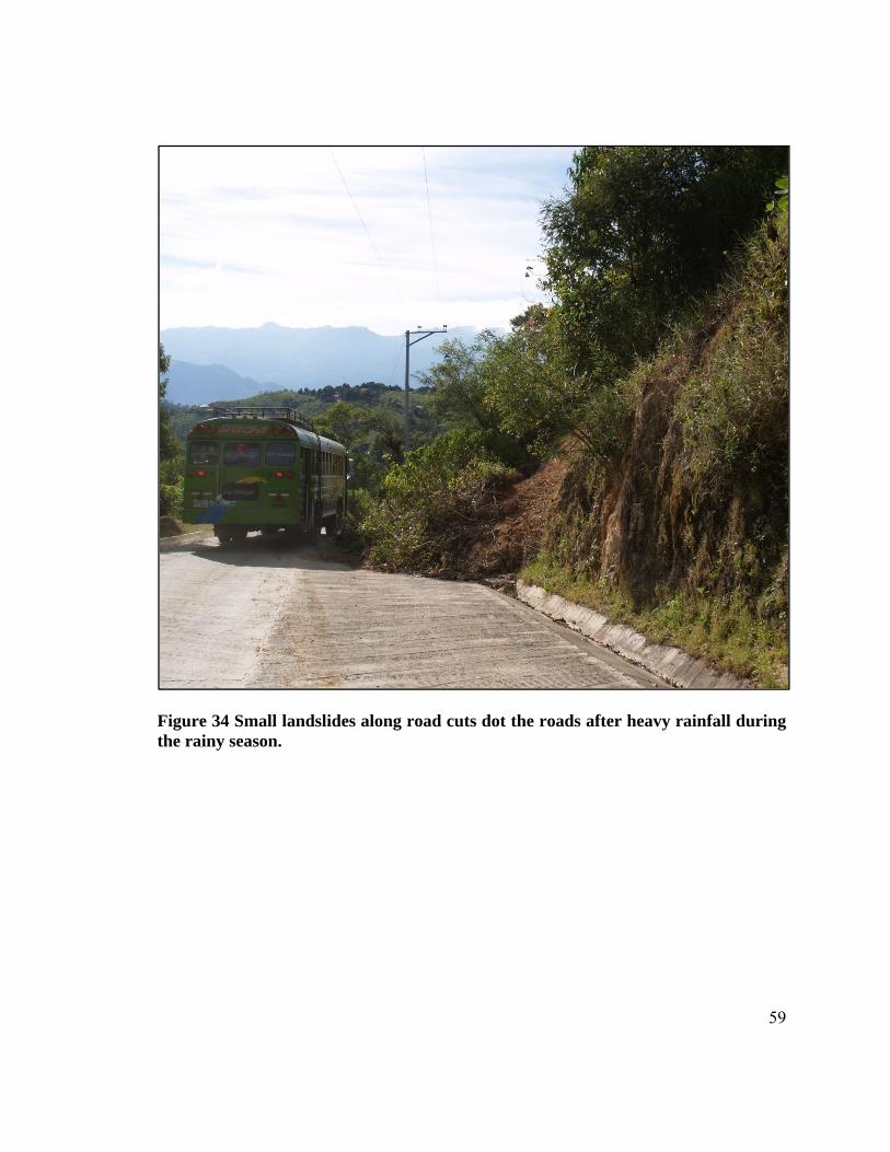
59
Figure 34 Small landslides along road cuts dot the roads after heavy rainfall during the rainy season.
60
IX.Conclusions
Landslide behavior in the Central American Highlands of El Salvador shows that,
although massive, landslides begin as small failures and evolve over many years.
Moreover, they do not possess enough water-entrained material or the energy to travel
long distances. This, therefore, suggests that these landslides pose a minimal threat to the
local population centers, such as La Palma and San Ignacio, located downstream. Roads,
houses, and farmland, located at landslide-prone locations, throughout the region,
however, are at the highest risk of danger to these landslides. This can result in the loss of
life, the interruption of commerce, increased road repair and maintenance cost, and the
loss of arable lands.
Slope stability is controlled by the geomorphology, groundwater hydrology, soil and
mineral composition, and seasonal rainfall. Soils overlay hard paleosurfaces at steep
angles on north-facing valleys. These soils contain allophane, imogolite and halloysite
which have a high permeability and a high cohesive strength. The observed process of
slope failure suggests that during intense rainstorms, such as tropical storms; depressions;
and hurricanes, the soils become saturated and lose their strength. In addition to the soil
saturation, continuous cutting of the toe of the slopes occurs as streams within the
drainages erode upstream. Once the streams have cut into the soils to a certain depth,
removing the aforementioned buttressing affects, and a large enough rainfall event
saturates the soils lose strength and fail.
61
X. Recommendations
It is the purpose of this study to identify the various geologic controls for landslides in the
Central American Highlands of El Salvador and provide a broad explanation of how each
control relates to the stability of the region. The following recommendations may provide
incentive and direction for further studies of landslides within the region:
1. In order to better understand the system of landslides, further studies on the
geology, and the local tectonic/structural effects need to be investigated. In
addition, the groundwater flow along the series of faults and fractures will greatly
benefit the hydrological flow below the surface.
2. Little is known about the morphology of the young slightly welded tuff that was
deposited and then weathered into the current soil in place. There may be vertical
fractures due to the horizontal cooling stresses, that increases the water infiltration
and the weathering of the deposit into its current soil state. The volcanic source
for this ash is also unknown. Further investigations may be able to identify
preserved fracture structures in the soil and their effects on groundwater flow.
3. Future investigations into the geotechnical properties of the soil material may
provide more insight into the likely future sites of landslides. This information
can then be used by the Ministry of Public Works and the local governments to
take preventative measures.
62
4. The clay mineralogy has not sufficiently identified due to time and resource
constraints. Clay mineralogy plays an important role in controlling the hydrology
and strength of these soils. Preliminary investigations identify halloysite,
allophane, imogolite, and presumably kaolinite and gibbsite as the main
components of the clay mineralogy of these soils. A more in depth analysis of the
clay mineral in this area is needed to better understand the overall soil strength of
the soils.
5. Once the various controls for landslides in the region are better understood, the
information can then be used to create model for predicting the location of future
landslides. This would be based on the intensity and duration of large rainfall
events such as hurricanes and tropical storms.
6. Although the national earthquake hazard map of El Salvador does not consider the
northern regions to be at high risk of earthquake induced landslides, the
possibility of a large event with an epicenter located inland is possible. Further
investigation is needed to identifying magnitudes and potential locations for a
large enough event to cause landslides in the region
7. Further investigations on the effects of anthropogenic and ecological factors on
the system (drainage, compaction, root anchoring, etc….) should also be
conducted.
8. A cost analysis on the effects of landslides on infrastructure and its economic
effects of repairing these structures. The investment in slope nailing equipment
63
might prove to be a valuable investment in reducing reconstruction costs in the
long-term.
9. Age-date the rock and soil boundary to confirm the difference in deposition age
and to confine the time needed for soil formation.
10. Future research can be done to study the recurrence interval of these catastrophic
landslides using the age dates of the inter-layered ash deposits or the actual clasts
entrained in the landslide deposits.
11. Future investigations for the possibility of using remote sensing coupled with
field data may be useful in the generation landslide hazard maps and also rainfall
threshold models for the region.
64
XI. References
Abayneh, E., S. Zauyah, et al. (2006). Genesis and classification of sesquioxidic soils
from volcanic rocks in sub-humid tropical highlands of ethiopia. Geoderma, 136
(3-4): pp 682-695
Baxter, Scott (1984) Lexico Estratigrafico De El Salvador. Comision Ejecutiva
Hidroelectrica Del Rio Lempa, San Salvador, El Salvador
Centro de Protección para Desastres (CEPRODE), Universidad Politécnica de Cataluña
(UPC) (2000) Estudio geológico ambiental de las microcuencas de los rios el
gramal, la palma, y san ignacio, depto. de chalatenango – el salvador. San
Salvador
Crone Anthony J, Baum Rex L, Lidke David J, Sather Damon N D, Bradley Lee-Ann,
Tarr Arthur C (2001) Landslides induced by hurricane mitch in el salvador – an
inventory and descriptions of selected features. USGS Open File Report 01-444,
Denver, Colorado
Duncan, J Michael, Wright, Stephen G (2005) Soil strength and slope stability. John
Wiley & Sons, Inc, New Jersey
Fieldes, M. (1955) Clay mineralogy of New Zealand soils; part II, Allophane and related
mineral colloids. New Zealand Journal of Science and Technology, Section B,
General Section, vol.37, no.3: pp.336-350
Japan Society of Environmental Engineers (JSCE) (2001) The january 13, 2001
earthquake off the coast of el salvador: investigation of damage to civil
engineering structures, buildings, and dwellings
Jongmans A G, L Denaix, F van Oort, A Nieuwenhuyse. (2000) Induration of c horizons
by allophane and imogolite in costa rican volcanic soils. Soil Science Society of
America Journal 64(1): pp 254-262
Lyon-Caen H, C Lasserre, et al. (2006) "Kinematics of the North American-Caribbean-
Cocos plates in Central America from new GPS measurements across the
Polochic-Motagua fault system." Geophysical Research Letters 33(19)
65
Mann,P, Rogers R, and Gahagan L, (2006) Chapter 8, Overview of plate tectonic history
and its unsolved tectonic problem, in J. Buncdschud (ed) Central America:
Geology, Resources, and Natural Hazards, Balkema Publishers, The Netherlands.
p. 205 – 241
Rao S M (1995) Mechanistic approach to the shear strength behaviour of allophanic soils.
Engineering Geology 40(3-4): 215-221
Rico M (1974) Mapa Pedologico De El Salvador [map]. 1st edition. 1:300,000. San
Salvador, El Salvador: National University of El Salvador School of Agronomic
Sciences, department of Soils
Rogers R D, H Karason, et al (2002) Epeirogenic uplift above a detached slab in northern
central america. Geology 30(11): pp 1031-1034
Rose W I, Bommer J J, Sandoval (2004) Natural hazards and risk mitigation in El
Salvador: An introduction. Geological Society of America, Special Paper 375, pp.
1-4
Rouse W C, A J Reading, et al. (1986) Volcanic soil properties in Dominica, West Indies.
Engineering Geology 23(1): pp 1-28
Sigurdsson H, Kelley S, Leckie R, Carey S, Bralower T, and King J, (2000) History of
circum-Caribbean explosive volcanism: 40Ar/39Ar dating of tephra layers, In
Leckie R, Sigurdsson H, et al, Proceedings of the ocean drilling program,
scientific results, Volume 165: College Station, Texas, Ocean Drilling Program,
p. 299–314
U.S. Geological Survey (2004) Magnitude 7.7 EL SALVADOR 2001 January 13
17:33:32 UTC. Preliminary Earthquake Report. USGS Earthquake Hazards
Program: Earthquake Report: El Salvador. 19 February 2008
<http://neic.usgs.gov/neis/eq_depot/2001/eq_010113/ >
U.S. Geological Survey (2004) “Magnitude 6.6 EL SALVADOR 2001 February 13
14:22:05 UTC. Preliminary Earthquake Report.” USGS Earthquake Hazards
Program: Earthquake Report: El Salvador. 19 February 2008
<http://neic.usgs.gov/neis/eq_depot/2001/eq_010213/ >
66
Wallace K B (1973) Structural behavior of residual soils of the continually wet highlands
of Papua New Guinea. Geotechnique 23(2): 16
Wohletz K (2006) Fractures in Welded Tuff. Geological Society of America Specail
Paper 408
Wesley L D (1973) Some basic engineering properties of halloysite and allophane clays
in Java, Indonesia. Geotechnique 23: pp 471-494
Wesley L D (1977) Shear strength properties of halloysite and allophane clays in Java,
Indonesia. Geotechnique 27(2): 13