Embed Size (px)
Citation preview
U.S. DEPARTMENT OF THE INTERIORU.S. GEOLOGICAL SURVEY
OPEN-FILE REPORT 01-173Version 1.0
Prepared in cooperation with the
SAN BERNARDINO VALLEY MUNICIPAL WATER DISTRICT, U.S. FOREST SERVICE (San Bernardino National Forest) and the CALIFORNIA DIVISION OF MINES
AND GEOLOGY
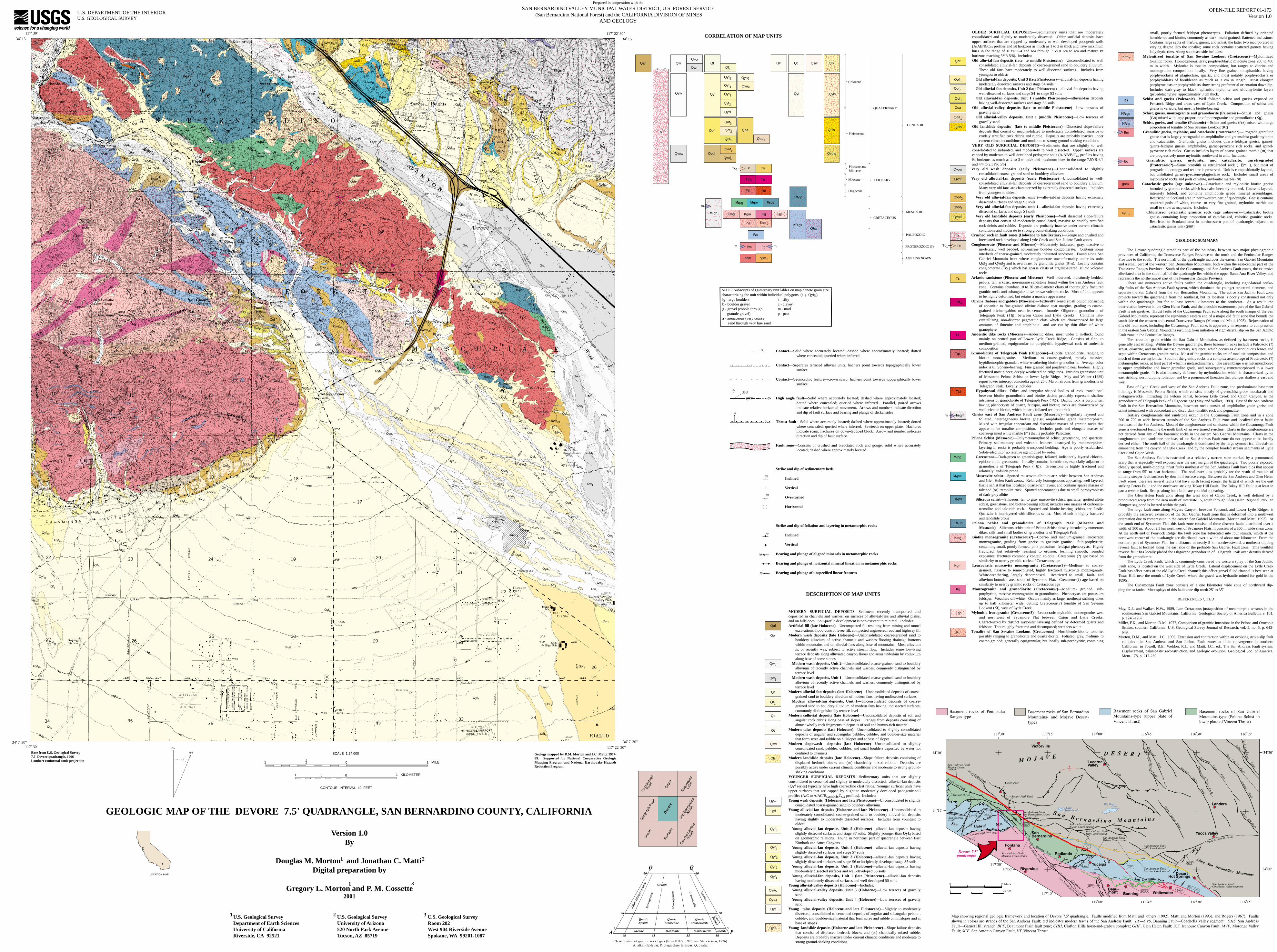
GEOLOGIC MAP OF THE DEVORE 7.5' QUADRANGLE, SAN BERNARDINO COUNTY, CALIFORNIA
Base from U.S. Geological Survey7.5' Devore quadrangle, 1966Lambert conformal conic projection 1 0 1 MILE
12
1 KILOMETER0.51
CONTOUR INTERVAL 40 FEET
SCALE 1:24,000
GN
MN
CORRELATION OF MAP UNITS
Qw
Ts
Version 1.0By
Douglas M. Morton and Jonathan C. Matti Digital preparation by
Gregory L. Morton and P. M. Cossette2001
21
1
Qaf
Qyf3
Qyf5
Qoa
Qof1
Qvof1
Qvof2
Qw Qf
Qyf
Qof
Qvof
Qof3
Ts
cgm1
Kt
QUATERNARY
CENOZOIC
MESOZOIC
Holocene
Pliocene andMiocene
TERTIARY
Pleistocene
CRETACEOUS
PALEOZOIC
AGE UNKNOWN
PROTEROZOIC (?)
Td3 Ta
Qols
Qyls
Ttp Ttd
NOTE: Subscripts of Quaternary unit lables on map denote grain size characterizing the unit within individual polygons. (e.g. Qyfb)
s - siltyc - clayeym - marlp - peat
lg- large bouldersb - boulder gravelg - gravel (cobble through granule gravel)a - arenaceous (very coarse sand through very fine sand
Qaf
Qc
Qsw
Qf
Qols
Qoa
Qof
Qvof1
Qvof2
Qvof
KgKmg KgcKgm
fz
Td3
Ta
Ttd
Kg
Kmg
Kgm
70
70
70
Contact—Solid where accurately located; dashed where approximately located; dotted where concealed; queried where inferred.
Contact—Separates terraced alluvial units, hachers point towards topographically lower surface.
Contact—Geomorphic feature—crown scarp; hachers point towards topographically lower surface.
High angle fault—Solid where accurately located; dashed where approximately located; dotted where concealed; queried where inferred. Parallel, paired arrows indicate relative horizontal movement. Arrows and numbers indicate direction and dip of fault surface and bearing and plunge of slickensides
Thrust fault—Solid where accurately located; dashed where approximately located; dotted where concealed; queried where inferred. Sawteeth on upper plate. Hachures indicate scarp; hachures on down-dropped block. Arrow and number indicates direction and dip of fault surface.
Fault zone—Consists of crushed and brecciated rock and gouge; solid where accurately located; dashed where approximately located
Strike and dip of sedimentary beds
Inclined
Vertical
Overturned
Horizontal
Strike and dip of foliation and layering in metamorphic rocks
Inclined
Vertical
Bearing and plunge of aligned minerals in metamorphic rocks
Bearing and plunge of horizontal mineral lineation in metamorphic rocks
Bearing and plunge of unspecified linear features
?
7530 S
Ttp
?
30
70
MODERN SURFICIAL DEPOSITS—Sediment recently transported and deposited in channels and washes, on surfaces of alluvial-fans and alluvial plains, and on hillslopes. Soil-profile development is non-existant to minimal. Includes:Artificial fill (late Holocene)—Uncompacted fill resulting from mining and tunnel
excavations, flood-control levee fill, compacted engineered road and highway fillModern wash deposits (late Holocene)—Unconsolidated coarse-grained sand to
bouldery alluvium of active channels and washes flooring drainage bottoms within mountains and on alluvial-fans along base of mountains. Most alluvium is, or recently was, subject to active stream flow. Includes some low-lying terrace deposits along alluviated canyon floors and areas underlain by colluvium along base of some slopes
Modern wash deposits, Unit 2—Unconsolidated coarse-grained sand to bouldery alluvium of recently active channels and washes; commonly distinguished by terrace level
Modern wash deposits, Unit 1—Unconsolidated coarse-grained sand to bouldery alluvium of recently active channels and washes; commonly distinguished by terrace level
Modern alluvial-fan deposits (late Holocene)—Unconsolidated deposits of coarse-grained sand to bouldery alluvium of modern fans having undissected surfaces
Modern alluvial-fan deposits, Unit 1—Unconsolidated deposits of coarse-grained sand to bouldery alluvium of modern fans having undissected surfaces; commonly distinguished by terrace level
Modern colluvial deposits (late Holocene)—Unconsolidated deposits of soil and angular rock debris along base of slopes. Ranges from deposits consisting of almost wholly rock fragments to deposits of soil and humus-rich material
Modern talus deposits (late Holocene)—Unconsolidated to slightly consolidated deposits of angular and subangular pebble-, cobble-, and boulder-size material that form scree and rubble on hillslopes and at base of slopes
Modern slopewash deposits (late Holocene)—Unconsolidated to slightly consolidated sand, pebbles, cobbles, and small boulders deposited by water not confined to channels
Modern landslide deposits (late Holocene)—Slope failure deposits consisting of displaced bedrock blocks and (or) chaotically mixed rubble. Deposits are possibly active under current climatic conditions and moderate to strong ground-shaking conditions
YOUNGER SURFICIAL DEPOSITS—Sedimentary units that are slightly consolidated to cemented and slightly to moderately dissected. alluvial-fan deposits (Qyf series) typically have high coarse:fine clast ratios. Younger surficial units have upper surfaces that are capped by slight to moderately developed pedogenic-soil profiles (A/C to A/AC/BcambricCox profiles). Includes:Young wash deposits (Holocene and late Pleistocene)—Unconsolidated to slightly
consolidated coarse-grained sand to bouldery alluvium. Young alluvial-fan deposits (Holocene and late Pleistocene)—Unconsolidated to
moderately consolidated, coarse-grained sand to bouldery alluvial-fan deposits having slightly to moderately dissected surfaces. Includes from youngest to oldest:
Young alluvial-fan deposits, Unit 5 (Holocene)—alluvial-fan deposits having slightly dissected surfaces and stage S7 soils. Slightly younger than Qyf4 based on geomorphic relations. Found in northeast part of quadrangle between East Kimbark and Ames Canyons
Young alluvial-fan deposits, Unit 4 (Holocene)—alluvial-fan deposits having slightly dissected surfaces and stage S7 soils
Young alluvial-fan deposits, Unit 3 (Holocene)—alluvial-fan deposits having slightly dissected surfaces and stage S6 or incipiently developed stage S5 soils
Young alluvial-fan deposits, Unit 2 (Holocene)—alluvial-fan deposits having moderately dissected surfaces and well-developed S5 soils
Young alluvial-fan deposits, Unit 1 (late Pleistocene)—alluvial-fan deposits having moderately dissected surfaces and well-developed S5 soils
Young alluvial-valley deposits (Holocene)—Includes:Young alluvial-valley deposits, Unit 5 (Holocene)—Low terraces of gravelly
sandYoung alluvial-valley deposits, Unit 4 (Holocene)—Low terraces of gravelly
sandYoung talus deposits (Holocene and late Pleistocene)—Slightly to moderately
dissected, consolidated to cemented deposits of angular and subangular pebble-, cobble-, and boulder-size material that form scree and rubble on hillslopes and at base of slopes
Young landslide deposits (Holocene and late Pleistocene)—Slope failure deposits that consist of displaced bedrock blocks and (or) chaotically mixed rubble. Deposits are probably inactive under current climatic conditions and moderate to strong ground-shaking conditions
DESCRIPTION OF MAP UNITS
fz
TcTc1
small, poorly formed feldspar phenocrysts. Foliation defined by oriented hornblende and biotite, commonly as dark, multi-grained, flattened inclusions. Contains large septa of marble, gneiss, and schist, the latter two incorporated in varying degree into the tonalite; some rock contains scattered garnets having kelyphytic rims. Along southeast side includes:
Mylonitized tonalite of San Sevaine Lookout (Cretaceous)—Mylonitized tonalitic rocks. Homogeneous, gray, porphyroblastic mylonite zone 200 to 400 m in width. Mylonite is tonalite composition, but ranges to diorite and monzogranite composition locally. Very fine grained to aphanitic, having porphyroclasts of plagioclase, quartz, and most notably porphyroclasts or porphyroblasts of hornblende as much as 3 cm in length. Most elongate porphyroclasts or porphyroblasts show strong preferential orientation down dip. Includes dark-gray to black, aphanitic mylonite and ultramylonite layers (psuedotachylyte) approximately 3 cm thick.
Schist and gneiss (Paleozoic)—Well foliated schist and gneiss exposed on Penstock Ridge and areas west of Lytle Creek. Composition of schist and gneiss is variable, but most is biotite-bearing
Schist, gneiss, monzogranite and granodiorite (Paleozoic)—Schist and gneiss ( ) mixed with large proportion of monzogranite and granodiorite (Kg)
Schist, gneiss, and tonalite (Paleozoic)—Schist and gneiss ( ) mixed with large proportion of tonalite of San Sevaine Lookout (Kt)
Granulitic gneiss, mylonite, and cataclasite (Proterozoic?)—Prograde granulitic gneiss that is largely retrograded to amphibolite and greenschist grade mylonite and cataclasite. Granulitic gneiss includes quartz-feldspar gneiss, garnet-quartz-feldspar gneiss, amphibolite, garnet-pyroxene rich rocks, and spinel-pyroxene rich rocks. Gneiss includes layers of coarse-grained marble (m) that are progressively more mylonitic southward in unit. Includes:
Granulitic gneiss, mylonite, and cataclasite, unretrograded (Proterozoic?)—Same protolith as retrograded rock ( ), but most of prograde mineralogy and texture is preserved. Unit is compositionally layered, but unfoliated garnet-pyroxene-plagioclase rock. Includes small areas of mylonitized rocks and pods of white, mylonitic marble (m)
Cataclastic gneiss (age unknown)—Cataclastic and mylonitic biotite gneiss intruded by granitic rocks which have also been mylonitized. Gneiss is layered, intensely folded, and contains amphibolite grade mineral assemblages. Restricted to Scotland area in northwestern part of quadrangle. Gneiss contains scattered pods of white, coarse- to very fine-grained, mylonitic marble too small to show at map scale. Includes:
Chloritized, cataclastic granitic rock (age unknown)—Cataclastic biotite gneiss containing large proportion of cataclasized, chloritic granitic rocks. Restricted to Scotland area in northwestern part of quadrangle, adjacent to cataclastic gneiss unit (gnm)
GEOLOGIC SUMMARY
The Devore quadrangle straddles part of the boundary between two major physiographicprovinces of California, the Transverse Ranges Province to the north and the Peninsular Ranges Province to the south. The north half of the quadrangle includes the eastern San Gabriel Mountains and a small part of the western San Bernardino Mountains, both within the east-central part of the Transverse Ranges Province. South of the Cucamonga and San Andreas Fault zones, the extensive alluviated area in the south half of the quadrangle lies within the upper Santa Ana River Valley, and represents the northernmost part of the Peninsular Ranges Province.
There are numerous active faults within the quadrangle, including right-lateral strike-slip faults of the San Andreas Fault system, which dominate the younger structural elements, and separate the San Gabriel from the San Bernardino Mountains. The active San Jacinto Fault zone projects toward the quadrangle from the southeast, but its location is poorly constrained not only within the quadrangle, but for at least several kilometers to the southeast. As a result, the interrelation between it, the Glen Helen Fault, and the probable easternmost part of the San Gabriel Fault is intrepretive. Thrust faults of the Cucamonga Fault zone along the south margin of the San Gabriel Mountains, represent the rejuvinated eastern end of a major old fault zone that bounds the south side of the western and central Transverse Ranges (Morton and Matti, 1993). Rejuvenation of this old fault zone, including the Cucamonga Fault zone, is apparently in response to compression in the eastern San Gabriel Mountains resulting from initiation of right-lateral slip on the San Jacinto Fault zone in the Peninsular Ranges.
The structural grain within the San Gabriel Mountains, as defined by basement rocks, isgenerally east striking. Within the Devore quadrangle, these basement rocks include a Paleozoic (?) schist, quartzite, and marble metasedimentary sequence, which occurs as discontinuous lenses and septa within Cretaceous granitic rocks. Most of the granitic rocks are of tonalitic composition, and much of them are mylonitic. South of the granitic rocks is a complex assemblage of Proterozoic (?) metamorphic rocks, at least part of which is metasedimentary. The assemblage was metamorphosed to upper amphibolite and lower granulite grade, and subsequently remetamorphosed to a lower metamorphic grade. It is also intensely deformed by mylonitization which is characterized by an east striking, north dipping foliation, and by a pronounced lineation that plunges shallowly east and west.
East of Lytle Creek and west of the San Andreas Fault zone, the predominant basementlithology is Mesozoic Pelona Schist, which consists mostly of greenschist grade metabasalt and metagraywacke. Intruding the Pelona Schist, between Lytle Creek and Cajon Canyon, is the granodiorite of Telegraph Peak of Oligocene age (May and Walker, 1989). East of the San Andreas Fault in the San Bernardino Mountains, basement rocks consist of amphibolite grade gneiss and schist intermixed with concordant and discordant tonalitic rock and pegmatite.
Tertiary conglomerate and sandstone occur in the Cucamonga Fault zone and in a zone 200 to 700 m wide between strands of the San Andreas Fault zone and localized thrust faults northeast of the San Andreas. Most of the conglomerate and sandstone within the Cucamonga Fault zone is overturned forming the north limb of an overturned syncline. Clasts in the conglomerate are not derived from any of the basement rocks in the eastern San Gabriel Mountains. Clasts in the conglomerate and sandstone northeast of the San Andreas Fault zone do not appear to be locally derived either. The south half of the quadrangle is dominated by the large symmetrical alluvial-fan emanating from the canyon of Lytle Creek, and by the complex braided stream sediments of Lytle Creek and Cajon Wash.
The San Andreas Fault is restricted to a relatively narrow zone marked by a pronounced scarp that is especially well exposed near the east margin of the quadrangle. Two poorly exposed, closely spaced, north-dipping thrust faults northeast of the San Andreas Fault have dips that appear to range from 55˚ to near horizontal. The shallower dips probably are the result of rotation of initially steeper fault surfaces by downhill surface creep. Between the San Andreas and Glen Helen Fault zones, there are several faults that have north facing scarps, the largest of which are the east striking Peters Fault and the northwest striking Tokay Hill Fault. The Tokay Hill Fault is at least in part a reverse fault. Scarps along both faults are youthful appearing.
The Glen Helen Fault zone along the west side of Cajon Creek, is well defined by a pronounced scarp from the area north of Interstate 15, south through Glen Helen Regional Park; an elongate sag pond is located within the park.
The large fault zone along Meyers Canyon, between Penstock and Lower Lytle Ridges, is probably the eastward extension of the San Gabriel Fault zone that is deformed into a northwest orientation due to compression in the eastern San Gabriel Mountains (Morton and Matti, 1993). At the south end of Sycamore Flat, this fault zone consists of three discreet faults distributed over a width of 300 m. About 2.5 km northwest of Sycamore Flats, it consists of a 300 m wide shear zone. At the north end of Penstock Ridge, the fault zone has bifurcated into four strands, which at the northwest corner of the quadrangle are distributed over a width of about one kilometer. From the northern part of Sycamore Flat, for a distance of nearly 5 km northwestward, a northeast dipping reverse fault is located along the east side of the probable San Gabriel Fault zone. This youthful reverse fault has locally placed the Oligocene granodiorite of Telegraph Peak over detritus derived from the granodiorite.
The Lytle Creek Fault, which is commonly considered the western splay of the San JacintoFault zone, is located on the west side of Lytle Creek. Lateral displacement on the Lytle Creek Fault has offset parts of the old Lytle Creek channel; this offset gravel-filled channel is best seen at Texas Hill, near the mouth of Lytle Creek, where the gravel was hydraulic mined for gold in the 1890s.
The Cucamonga Fault zone consists of a one kilometer wide zone of northward dip-ping thrust faults. Most splays of this fault zone dip north 25 to 35 .
REFERENCES CITED
May, D.J., and Walker, N.W., 1989, Late Cretaceous juxtaposition of metamorphic terranes in the southeastern San Gabriel Mountains, California: Geological Society of America Bulletin, v. 101, p. 1246-1267
Miller, F.K., and Morton, D.M., 1977, Comparison of granitic intrusions in the Pelona and Orocopia Schists, southern California: U.S. Geological Survey Journal of Research, vol. 5, no. 5, p. 643-649.
Morton, D.M., and Matti, J.C., 1993, Extension and contraction within an evolving strike-slip fault complex: the San Andreas and San Jacinto Fault zones at their convergence in southern California, in Powell, R.E., Weldon, R.J., and Matti, J.C., ed., The San Andreas Fault system: Displacement, palinspastic reconstruction, and geologic evolution: Geological Soc. of America, Mem. 178, p. 217-230.
cgm1
gnm
gnm
m
Oligocene
OLDER SURFICIAL DEPOSITS—Sedimentary units that are moderately consolidated and slightly to moderately dissected. Older surficial deposits have upper surfaces that are capped by moderately to well developed pedogenic soils (A/AB/B/Cox profiles and Bt horizons as much as 1 to 2 m thick and have maximum hues in the range of 10YR 5/4 and 6/4 through 7.5YR 6/4 to 4/4 and mature Bt horizons reaching 5YR 5/6). Includes:Old alluvial-fan deposits (late to middle Pleistocene)—Unconsolidated to well
consolidated alluvial-fan deposits of coarse-grained sand to bouldery alluvium. These old fans have moderately to well dissected surfaces. Includes from youngest to oldest:
Old alluvial-fan deposits, Unit 3 (late Pleistocene)—alluvial-fan deposits having moderately dissected surfaces and stage S4 soils
Old alluvial-fan deposits, Unit 2 (late Pleistocene)—alluvial-fan deposits having well-dissected surfaces and stage S4 to stage S3 soils
Old alluvial-fan deposits, Unit 1 (middle Pleistocene)—alluvial-fan deposits having well-dissected surfaces and stage S3 soils
Old alluvial-valley deposits (late to middle Pleistocene)—Low terraces of gravelly sand
Old alluvial-valley deposits, Unit 1 (middle Pleistocene)—Low terraces of gravelly sand
Old landslide deposits (late to middle Pleistocene)—Dissected slope-failure deposits that consist of unconsolidated to moderately consolidated, massive to crudely stratified rock debris and rubble. Deposits are probably inactive under current climatic conditions and moderate to strong ground-shaking conditions
VERY OLD SURFICIAL DEPOSITS—Sediments that are slightly to well consolidated to indurated, and moderately to well dissected. Upper surfaces are capped by moderate to well developed pedogenic soils (A/AB/B/Cox profiles having Bt horizons as much as 2 to 3 m thick and maximum hues in the range 7.5YR 6/4 and 4/4 to 2.5YR 5/6)Very old wash deposits (early Pleistocene)—Unconsolidated to slightly
consolidated coarse-grained sand to bouldery alluviumVery old alluvial-fan deposits (early Pleistocene)—Unconsolidated to well-
consolidated alluvial-fan deposits of coarse-grained sand to bouldery alluvium. Many very old fans are characterized by extremely dissected surfaces. Includes from youngest to oldest:
Very old alluvial-fan deposits, unit 2—alluvial-fan deposits having extremely dissected surfaces and stage S2 soils
Very old alluvial-fan deposits, unit 1—alluvial-fan deposits having extremely dissected surfaces and stage S1 soils
Very old landslide deposits (early Pleistocene)—Well dissected slope-failure deposits that consist of moderately consolidated, massive to crudely stratified rock debris and rubble. Deposits are probably inactive under current climatic conditions and moderate to strong ground-shaking conditions
Crushed rock in fault zones (Holocene to late Tertiary)—Gouge and crushed and brecciated rock developed along Lytle Creek and San Jacinto Fault zones
Conglomerate (Pliocene and Miocene)—Moderately indurated, gray, massive to moderately well bedded, non-marine boulder conglomerate. Contains some interbeds of coarse-grained, moderately indurated sandstone. Found along San Gabriel Mountain front where conglomerate unconformably underlies units Qof2 and Qvof2 and is overthrust by granulitic gneiss ( ). Locally contains conglomerate (Tc1) which has sparse clasts of argillic-altered, silicic volcanic rocks
Arkosic sandstone (Pliocene and Miocene)—Well indurated, indistinctly bedded, pebbly, tan, arkosic, non-marine sandstone found within the San Andreas fault zone. Contains abundant 10 to 20 cm-diameter clasts of thouroughly fractured granitic rocks and subangular, olive-brown volcanic rocks. Most of unit appears to be highly deformed, but retains a massive appearance
Olivine diabase and gabbro (Miocene)—Texturally zoned small pluton consisting of aphanitic to fine-grained olivine diabase near margins, grading to coarse-grained olivine gabbro near its center. Intrudes Oligocene granodiorite of Telegraph Peak (Ttp) between Cajon and Lytle Creeks. Contains late-crystallizing, non-discrete pegmatitic clots which are characterized by large amounts of ilmenite and amphibole and are cut by thin dikes of white granophyre
Andesitic dike rocks (Miocene)—Andesitic dikes, most under 1 m-thick, found mainly on central part of Lower Lytle Creek Ridge. Consists of fine- to medium-grained, equigranular to porphyritic hypabyssal rock of andesitic composition
Granodiorite of Telegraph Peak (Oligocene)—Biotite granodiorite, ranging to biotite monzogranite. Medium- to coarse-grained, mostly massive, hypidiomorphic-granular, white-weathering biotite granodiorite. Average color index is 8. Sphene-bearing. Fine grained and porphyritic near borders. Highly fractured most places; deeply weathered on ridge tops. Intrudes greenstone unit of Mesozoic Pelona Schist on lower Lytle Ridge. May and Walker (1989) report lower intercept concordia age of 25.6 Ma on zircons from granodiorite of Telegraph Peak. Locally includes:
Hypabyssal dikes—Dikes and irregular shaped bodies of rock transitional between biotite granodiorite and biotite dacite; probably represent shallow intrusions of granodiorite of Telegraph Peak (Ttp). Dacitic rock is porphyritic, having phenocrysts of quartz, feldspar, and biotite; rocks are characterized by well oriented biotite, which imparts foliated texture to rock
Gneiss east of San Andreas Fault zone (Mesozoic)—Irregularly layered and foliated, heterogeneous biotite gneiss; amphibolite grade metamorphism. Mixed with irregular concordant and discordant masses of granitic rocks that appear to be tonalite composition. Includes pods and elongate masses of coarse-grained white marble (m) that is probably Paleozoic
Pelona Schist (Mesozoic)—Polymetamorphosed schist, greenstone, and quartzite. Primary sedimentary and volcanic features destroyed by metamorphism; layering in rocks is probably transposed bedding. Age is poorly established. Subdivided into (no relative age implied by order):
Greenstone—Dark-green to greenish-gray, foliated, indistinctly layered chlorite-epidote-albite greenstone. Locally contains hornblende, especially adjacent to granodiorite of Telegraph Peak (Ttp). Greenstone is highly fractured and relatively landslide prone
Muscovite schist—Spotted muscovite-albite-quartz schist between San Andreas and Glen Helen Fault zones. Relatively homogeneous appearing, well layered, fissile schist that has localized quartz-rich layers, and contains sparse masses of talc and (or) tremolite rock. Spotted appearance is due to small porphyroblasts of dark-gray albite
Siliceous schist—Siliceous, tan to gray muscovite schist, quartzite, spotted albite schist, greenstone, and biotite-bearing schist; includes rare masses of carbonate-tremolite and talc-rich rock. Spotted and biotite-bearing schists are fissile. Quartzite is interlayered with siliceous schist. Most of unit is highly fractured and landslide prone
Pelona Schist and granodiorite of Telegraph Peak (Miocene and Mesozoic)—Siliceous schist unit of Pelona Schist closely intruded by numerous dikes, sills, and small bodies of granodiorite of Telegraph Peak
Biotite monzogranite (Cretaceous?)—Coarse- and medium-grained leucocratic monzogranite, grading from gneiss to gneissic granite. Sub-porphyritic, containing small, poorly formed, pink potassium feldspar phenocrysts. Highly fractured, but relatively resistant to erosion, forming smooth, rounded exposures; fractures commonly contain epidote. Cretaceous (?) age based on similarity to nearby granitic rocks of Cretaceous age
Leucocratic muscovite monzogranite (Cretaceous?)—Medium- to coarse-grained, massive to semi-foliated, highly fractured muscovite monzogranite. White-weathering, largely decomposed. Restricted to small, fault- and alluvium-bounded area south of Sycamore Flat. Cretaceous(?) age based on similarity to nearby granitic rocks of Cretaceous age
Monzogranite and granodiorite (Cretaceous?)—Medium- grained, sub-porphyritic, massive monzogranite to granodiorite. Phenocrysts are potassium feldspar. Weathers off-white. Occurs mainly as large, northeast striking dikes up to half kilometer wide, cutting Cretaceous(?) tonalite of San Sevaine Lookout (Kt), west of Lytle Creek
Mylonitic leucogranite (Cretaceous?)—Leucocratic mylonitic monzogranite west and northwest of Sycamore Flat between Cajon and Lytle Creeks. Characterized by distinct mylonitic layering defined by deformed quartz and feldspar. Thouroughly fractured and decomposed; weathers white
Tonalite of San Sevaine Lookout (Cretaceous)—Hornblende-biotite tonalite, possibly ranging to granodiorite and quartz diorite. Foliated, gray, medium- to coarse-grained; generally equigranular, but locally sub-porphyritic, containing
Qw2
Qw1
Qc Qsw Qls
Qyw Qyt
Qyf2
Qyf4
Qyf1
Qof2
Qvow
m
Qya5
Qya4
TcTc1
Qt
Qf1
Qw2
Qw1
Qls
Qof1
Qof3
Qof2
Qoa1
Qvow
Ktm1
70
3
1 U.S. Geological SurveyDepartment of Earth SciencesUniversity of CaliforniaRiverside, CA 92521
2 U.S. Geological SurveyUniversity of Arizona520 North Park AvenueTucson, AZ 85719
U.S. Geological SurveyRoom 202West 904 Riverside AvenueSpokane, WA 99201-1087
3
15
Qf1
Qoa1
Qt
? ?
34 7' 30"117 30'
Geology mapped by D.M. Morton and J.C. Matti, 1977-89. Supported by National Cooperative Geologic Mapping Program and National Earthquake Hazards Reduction Program
34 7' 30"
117 22' 30"
34 15'
117 22' 30"34 15'
117 30'
Ktm1
Qvols
Qvols
m
m
Qyf3
Qyls
Qyf5
Qyw
Qyf
Qyf4
Qyf2
Qyf1
Qya5
Qya4
Qyt
Kt
Kgc
Syenite Monzonite Monzodiorite Diorite
QuartzSyenite
QuartzMonzonite
QuartzMonzodiorite
Diorite
Quartz
Syen
ogra
nite
Mon
zogr
anit
e Granodiorite
Tonalite
Alk
ali-
feld
spar
gra
nite Granite
A P
5
20
60
5
20
60
90 65 35 10
Classification of granitic rock types (from IUGS, 1976, and Streckeisen, 1976).
A, alkali-feldspar; P, plagioclase feldspar; Q, quatrz
Gua
sti
Tele
grap
h Pe
ak
Silv
erw
ood
Lake
Caj
on
San
Ber
nard
ino
Nor
th
Font
ana
Dev
ore
Cuc
amon
ga P
eak
San
Ber
nard
ino
Sou
th
?
LOCATION MAP
m
m
Miocene


![[Livro] Devore (Cap. 2)](https://img.pdfslide.net/doc/110x75/55cf9768550346d033917952/livro-devore-cap-2.jpg)