Embed Size (px)
Citation preview

Geologic Map of the Soza Canyon 7½' Quadrangle, Cochise and Pima Counties, Arizona
by
Jon E. Spencer, Stephen M. Richard, Joseph P. Cook, William R. Dickinson, Steven H. Lingrey, and Jerome H. Guynn
Arizona Geological Survey Digital Geologic Map DGM-61
version 2.0
May, 2009
Scale 1:24,000 (1 sheet, with text)
Arizona Geological Survey
416 W. Congress St., #100, Tucson, Arizona 85701
This geologic map was funded in part by the USGS National Cooperative Geologic Mapping Program, award no. 06HQAG0051. The views and conclusions contained in
this document are those of the authors and should not be interpreted as necessarily representing the official policies, either expressed or implied, of the U.S. Government.
Geologic Map of the Soza Canyon 7½' Quadrangle, Cochise and Pima Counties, Arizona
by
Jon E. Spencer, Stephen M. Richard, Joseph P. Cook, William R. Dickinson, Steven H. Lingrey, and Jerome H. Guynn
INTRODUCTION
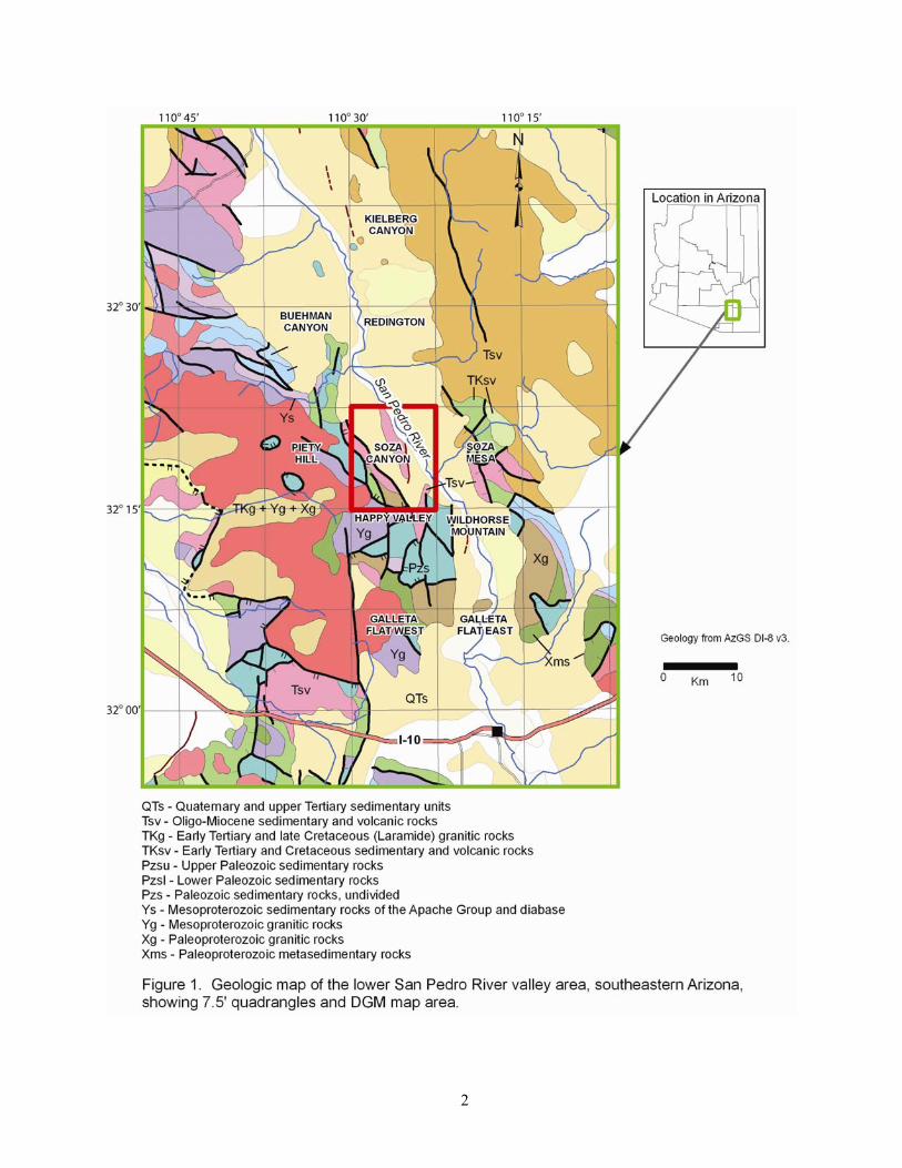
The Soza Canyon 7 ½′ Quadrangle includes part of the San Pedro River, flanking valley fill, and bedrock on the southwest side of the valley that forms part of the Rincon Mountains (Figure 1). Production of this new geologic map continues the Arizona Geological Survey mapping program of the San Pedro River valley. This mapping was done under the joint State-Federal STATEMAP program, as specified in the National Geologic Mapping Act of 1992, and was jointly funded by the Arizona Geological Survey and the U.S. Geological Survey under STATEMAP Program Contract award number 06HQAG0051. Mapping was compiled digitally using ESRI ArcGIS software.
Parts of the Soza Canyon 7 ½′ Quadrangle were mapped previously by Thorman and Drewes (1981), Lingrey (1982), Dickinson (1987, 1991, 1998), and Dickinson and Olivares (1987). Maps of adjacent areas include those by Creasey and Theodore (1975), Drewes (1974), and Bykerk-Kauffman (2008). Studies of Cenozoic sedimentary strata in the Quadrangle include those by Chew (1962), Clay (1970), and Dickinson (2003).
1
2
3
STRUCTURAL GEOLOGY
Bedrock in the northeastern Rincon Mountains forms part of the northeastern flank of the
Catalina-Rincon metamorphic core complex (Rehrig and Reynolds, 1980; Davis, 1980; Keith et al., 1980; Lingrey, 1982; Spencer and Reynolds, 1989; Dickinson, 1991). This complex is bounded above by the Catalina – San Pedro detachment fault, which is arched over the Rincon Mountains. At least 28 km of top-southwest displacement on this fault is responsible for tectonic exhumation of much of the rock in the range (Dickinson, 1991). From structurally lowest to highest in the map area, the sequence of structural units consists of the following: (1) A largely undeformed crystalline core of porphyritic biotite granite (Proterozoic) and heterogeneous pegmatitic leucogranite (Eocene). (2) A metamorphic carapace consisting of tectonite marble and quartzite (Paleozoic protolith), carbonate-matrix stretched-clast conglomerate (Jurassic protolith), chloritic, quartzo-feldspathic schist (probably Mesozoic protolith), and granitoid rocks (Proterozoic). (3) The metamorphic carapace is bounded above by the San Pedro detachment fault, above which are three rock assemblages, as follows: (A) upper Paleozoic carbonates and Mesozoic clastic and carbonate rocks of the Bisbee Group, (B) Proterozoic granite and Pinal Schist that is thrust over the Paleozoic and Mesozoic strata of assemblage A, and (C) Oligo-Miocene volcanic and sedimentary rocks that depositionally overlie assemblages A and B and the thrust fault that separates them (see cross sections on Plate 1). The Tertiary strata of assemblage C form a fanning-upward sequence that was deposited during tilting and displacement on the San Pedro fault (e.g., Dickinson, 1991).
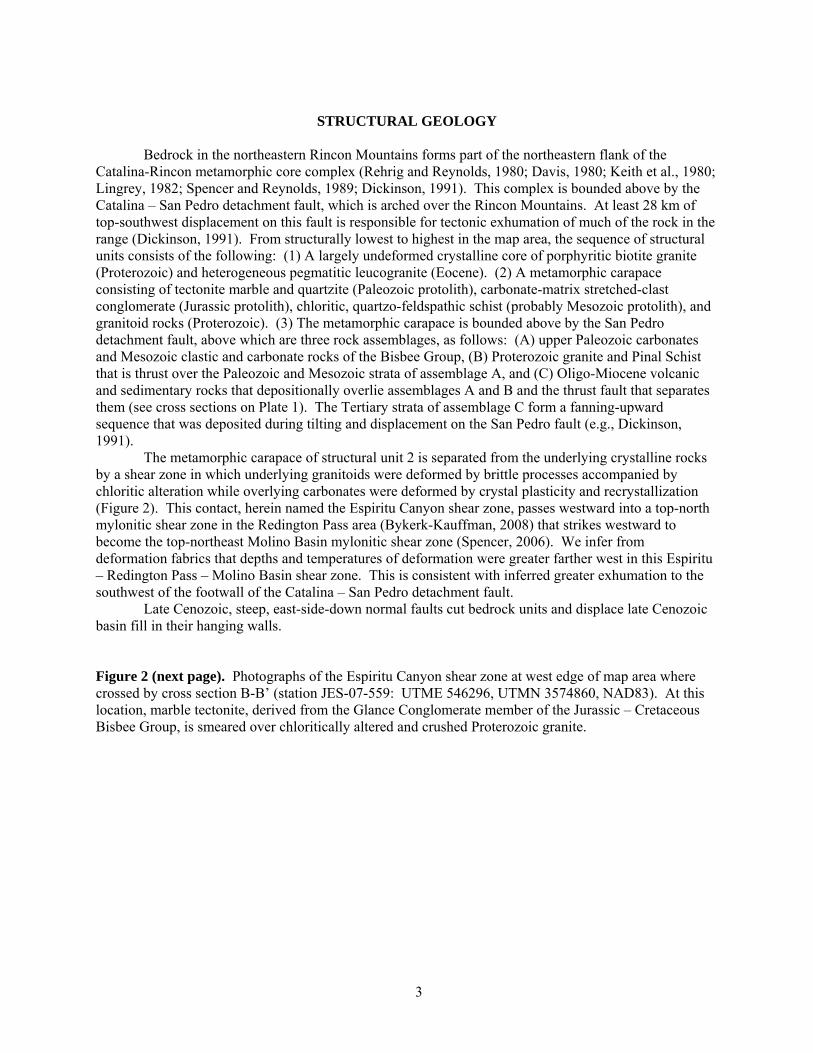
The metamorphic carapace of structural unit 2 is separated from the underlying crystalline rocks by a shear zone in which underlying granitoids were deformed by brittle processes accompanied by chloritic alteration while overlying carbonates were deformed by crystal plasticity and recrystallization (Figure 2). This contact, herein named the Espiritu Canyon shear zone, passes westward into a top-north mylonitic shear zone in the Redington Pass area (Bykerk-Kauffman, 2008) that strikes westward to become the top-northeast Molino Basin mylonitic shear zone (Spencer, 2006). We infer from deformation fabrics that depths and temperatures of deformation were greater farther west in this Espiritu – Redington Pass – Molino Basin shear zone. This is consistent with inferred greater exhumation to the southwest of the footwall of the Catalina – San Pedro detachment fault.
Late Cenozoic, steep, east-side-down normal faults cut bedrock units and displace late Cenozoic basin fill in their hanging walls. Figure 2 (next page). Photographs of the Espiritu Canyon shear zone at west edge of map area where crossed by cross section B-B’ (station JES-07-559: UTME 546296, UTMN 3574860, NAD83). At this location, marble tectonite, derived from the Glance Conglomerate member of the Jurassic – Cretaceous Bisbee Group, is smeared over chloritically altered and crushed Proterozoic granite.
4
URANIUM MINERALIZATION Minor uranium mineralization at the Blue Rock mine is hosted by chloritic metamorphic rocks
that form a low-angle fault sliver directly below the San Pedro detachment fault. These metamorphic rocks consist of green, chloritic rock derived from fine-grained granitoids, and fine-grained sandstone and siltstone with well developed foliation that could be transposed bedding. This unit locally includes lenses of marble tectonite, and is bounded below by a low-angle fault and underlying, locally foliated Proterozoic granite.
Disseminated, low-grade uranium in the Blue Rock mine area includes rare and very fine grained uranophane and autinite (Granger and Raup, 1962; Warner, 1982), but is primarily invisible (no uranium minerals were identified in our investigation). Warner (1982) inferred that uranium had been adsorbed onto hematite within the chloritic metamorphic rocks, and in some cases was especially concentrated in areas where pyrite had been oxidized. Elevated Cu, Pb, Zn, and Mo are associated with U, as is fluorite (Warner, 1982).
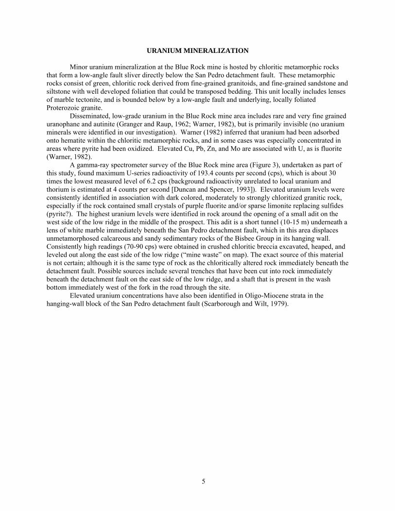
A gamma-ray spectrometer survey of the Blue Rock mine area (Figure 3), undertaken as part of this study, found maximum U-series radioactivity of 193.4 counts per second (cps), which is about 30 times the lowest measured level of 6.2 cps (background radioactivity unrelated to local uranium and thorium is estimated at 4 counts per second [Duncan and Spencer, 1993]). Elevated uranium levels were consistently identified in association with dark colored, moderately to strongly chloritized granitic rock, especially if the rock contained small crystals of purple fluorite and/or sparse limonite replacing sulfides (pyrite?). The highest uranium levels were identified in rock around the opening of a small adit on the west side of the low ridge in the middle of the prospect. This adit is a short tunnel (10-15 m) underneath a lens of white marble immediately beneath the San Pedro detachment fault, which in this area displaces unmetamorphosed calcareous and sandy sedimentary rocks of the Bisbee Group in its hanging wall. Consistently high readings (70-90 cps) were obtained in crushed chloritic breccia excavated, heaped, and leveled out along the east side of the low ridge (“mine waste” on map). The exact source of this material is not certain; although it is the same type of rock as the chloritically altered rock immediately beneath the detachment fault. Possible sources include several trenches that have been cut into rock immediately beneath the detachment fault on the east side of the low ridge, and a shaft that is present in the wash bottom immediately west of the fork in the road through the site.
Elevated uranium concentrations have also been identified in Oligo-Miocene strata in the hanging-wall block of the San Pedro detachment fault (Scarborough and Wilt, 1979).
5
Figure 3. Sketch map of the Blue Rock Mine area showing field measurements of radioactivity from the uranium-238 decay series, in counts per second. Field data were acquired with an EG&G geoMetrics model GR-310 gamma-ray spectrometer equipped with an external detector containing a 347-cm3, thallium-doped, sodium-iodide crystal. Count time was 100 seconds, each measurement is the average of two counts.
REFERENCES CITED Bykerk-Kauffman, A., 2008, Geologic map of the northeastern Santa Catalina Mountains, Pima County,
Arizona: Arizona Geological Survey Contributed Map CM-08-A, scale 1:24,000. Chew, R.T., III, 1962, The Mineta Formation, a middle Tertiary unit in southeastern Arizona: Arizona
Geological Society Digest, v. 5, p. 35-43. Clay, D.W., 1970, Stratigraphy and petrology of the Mineta Formation in Pima and eastern Cochise
Counties, Arizona: Tucson, University of Arizona, Ph.D. Dissertation, 187 p. Creasey, S.C., and Theodore, T.G., 1975, Preliminary reconnaissance geologic map of the Bellota Ranch
quadrangle, Pima County, Arizona: U.S. Geological Survey Open-File Report 75-0295, 2 sheets, scale 1:31,680.
Davis, G.H., 1980, Structural characteristics of metamorphic core complexes, southern Arizona, in Crittenden, M.D., Jr., Coney, P.J., and Davis, G.H., eds., Cordilleran metamorphic core complexes: Geological Society of America Memoir 153, p. 35-77.
6
Dickinson, W.R., 1987, General geologic map of Catalina core complex and San Pedro trough, Arizona: Arizona Geological Survey Miscellaneous Map MM-87-A, 15 sheets, scale 1:62,500, with 18 p. text.
Dickinson, W.R., 1991, Tectonic setting of faulted Tertiary strata associated with the Catalina core complex in southern Arizona: Geological Society of America, Special Paper 264, 106 p.
Dickinson, W.R., 1998, Facies map of post-mid-Miocene Quiburis Formation, San Pedro trough, Pinal, Pima, Gila, Graham, and Cochise Counties, Arizona: Arizona Geological Survey Contributed Map CM-98-A, Ten sheets, scale 1:24,000, with 6 p. text.
Dickinson, W.R., 2003, Depositional facies of the Quiburis Formation, basin fill of the San Pedro trough, southeastern Arizona Basin and Range Province, in Raynolds, R.G., and Flores, R.M., eds., 2003, Cenozoic systems of the Rocky Mountain region: Denver, Rocky Mountain Section, SEPM (Society for Sedimentary Geology), p. 157-181.
Dickinson, W.R., and Olivares, M.D., 1987, Reconnaissance geologic map of Mineta Ridge and Banco Ridge area, Pima and Cochise counties, Arizona: Arizona Geological Survey Miscellaneous Map MM-87-C, scale 1:24,000, with 3 p. text.
Drewes, H., 1974, Geologic map and sections of the Happy Valley Quadrangle, Cochise County, Arizona: U.S. Geological Survey Miscellaneous Investigations Series Map I-832, scale 1:48,000.
Duncan, J.T., and Spencer, J.E., 1993, Geology and uranium concentrations in Verde Valley, Yavapai County, Arizona, in Spencer, J.E., ed., Radon in Arizona: Arizona Geological Survey Bulletin 199, Plate 2, scale 1:32,200.
Granger, H.C., and Raup, R.B., 1962, Reconnaissance study of uranium deposits in Arizona: U.S. Geological Survey Bulletin 1147-A, 54 p.
Keith, S. B., Reynolds, S. J., Damon, P. E., Shafiqullah, M., Livingston, D. E., and Pushkar, P. D., 1980, Evidence for multiple intrusion and deformation within the Santa Catalina-Rincon-Tortolita crystalline complex, southeastern Arizona, in Crittenden, M.D., Jr., Coney, P.J., and Davis, G.H., eds., Cordilleran metamorphic core complexes: Geological Society of America Memoir 153, p. 217-267.
Lingrey, S. H., 1982, Structural geology and tectonic evolution of the northeastern Rincon Mountains, Cochise and Pima Counties, Arizona: Tucson, University of Arizona, unpublished Ph.D. thesis, 202 p.
Rehrig, W.A., and Reynolds, S.J., 1980, Geologic and geochronologic reconnaissance of a northwest-trending zone of metamorphic core complexes in southern and western Arizona, in Crittenden, M.D., Jr., Coney, P.J., and Davis, G.H., eds., Cordilleran metamorphic core complexes: Geological Society of America Memoir 153, p. 131-157.
Richard, S.M., and Kneale, S.M., 2003, Geologic map of Arizona: Arizona Geological Survey Digital Information Series DI-8, version 3 (includes ESRI ArcInfo export files, Microsoft Access 2000 database, ESRI ArcView 3.2 Project).
Scarborough, R.B., and Wilt, J.C., 1979, A study of uranium favorability of Cenozoic sedimentary rocks, Basin and Range province, Arizona - Part I. General geology and chronology of pre-late Miocene Cenozoic sedimentary rocks: Tucson, Arizona Bureau of Geology and Mineral Technology Open-File Report 79-1, 101 p.
Spencer, J.E., 2006, A geologist’s guide to the core complex geology along the Catalina Highway, Tucson area, Arizona: Arizona Geological Survey Open File Report 06-01, ver. 1.1, 38 p.
Spencer, J.E., and Reynolds, S.J., 1989, Middle Tertiary tectonics of Arizona and the Southwest, in Jenney, J.P., and Reynolds, S.J., eds., Geologic evolution of Arizona: Arizona Geological Society Digest, v. 17, p. 539-574.
Thorman, C. H., and Drewes, H., 1981, Geology of the Rincon wilderness study area, Pima County, Arizona, in Mineral Resources of the Rincon wilderness study area, Pima County, Arizona: U.S. Geological Survey Bulletin 1500, p. 5-37, with map, scale 1:48,000.
Warner, J.D., 1982, Geology and mineralization of the Blue Rock mine, northeastern Rincon Mountains, Pima County, Arizona: Tucson, University of Arizona, M.S., thesis, 132 p.
7
MAP UNITS
SURFICIAL MAP UNITS Other units Plowed areas - Historically or actively plowed fields, irrigated pastures, and other lightly
disturbed ground. d Disturbed ground – Heavily disturbed ground due to agriculture, extensive excavation, or
construction of earth dams. Qtc Quaternary hillslope talus and colluvium – Unconsolidated to weakly consolidated, very
poorly sorted angular rock debris deposited at the base of bedrock slopes. San Pedro River alluvium
Quaternary San Pedro River sediments derived from both adjacent and upstream piedmont and basin fill alluvium are transported north through the mapped area towards the San Pedro’s confluence with the Gila River. Pleistocene age river deposits are located outside the modern floodplain and stand much higher than the present-day channel. Prior to about 1900, the San Pedro was a low energy, unentrenched, narrow channel and cienega drainage system (Hereford, 1993). Late Holocene river valley and floodplain deposits were much more widespread than the modern incised meandering system. Modern and historical San Pedro deposits are confined to the entrenched meandering swath occupying the lowest elevations in the mapped area. Qycr Active river channel deposits - Deposits are dominantly unconsolidated, very poorly sorted
sandy to cobbly beds exhibiting bar and swale microtopography but can range from fine silty beds to coarse gravelly bars in meandering reaches based on position within the channel. Clasts are typically well-rounded but may be angular to sub angular. Qycr deposits are typically unvegetated to lightly vegetated and exhibit no soil development. Qycr deposits are entrenched from 30 cm to 5 meters or more below adjacent early historical floodplain deposits depending on location, geomorphic relationship, and local channel conditions. Although much of the San Pedro River was a perennial stream historically, some modern sections are dry or marshy at the surface throughout much of the year. These deposits are the first to become submerged during flow events and can be subject to deep, high velocity flow and lateral bank erosion.
Qy4r Flood channel and low terrace deposits- Deposits are dominantly unconsolidated, very
poorly sorted sandy to cobbly beds exhibiting bar and swale microtopography but can range from fine silty beds to coarse gravelly bars in meandering reaches based on position within the channel. Clasts are typically well-rounded but may be angular to sub angular. Qycr deposits are typically unvegetated to lightly vegetated and exhibit no soil development. Qycr deposits are entrenched from 30 cm to 5 meters or more below adjacent early historical floodplain deposits depending on location, geomorphic relationship, and local channel conditions. Although much of the San Pedro River was a perennial stream historically, some modern sections are dry or marshy at the surface throughout much of the year. These deposits are the first to become submerged during moderate to extreme flow events and can be subject to deep, high velocity flow and lateral bank erosion.
8
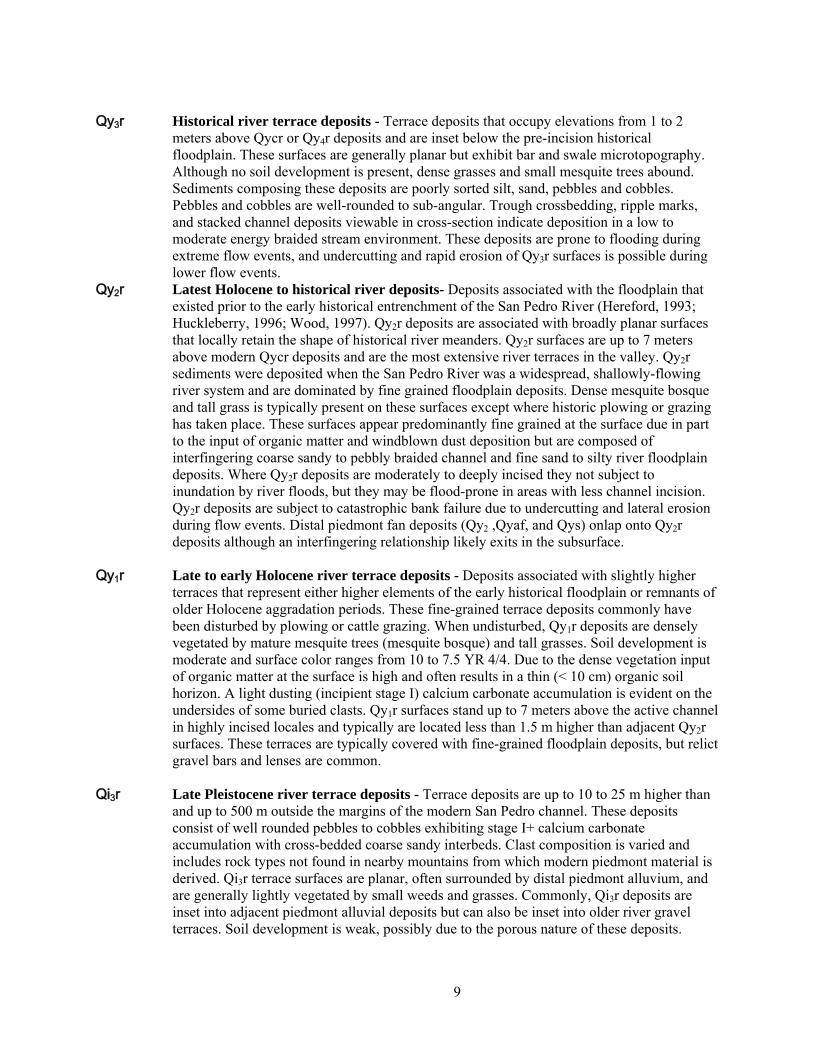
Qy3r Historical river terrace deposits - Terrace deposits that occupy elevations from 1 to 2
meters above Qycr or Qy4r deposits and are inset below the pre-incision historical floodplain. These surfaces are generally planar but exhibit bar and swale microtopography. Although no soil development is present, dense grasses and small mesquite trees abound. Sediments composing these deposits are poorly sorted silt, sand, pebbles and cobbles. Pebbles and cobbles are well-rounded to sub-angular. Trough crossbedding, ripple marks, and stacked channel deposits viewable in cross-section indicate deposition in a low to moderate energy braided stream environment. These deposits are prone to flooding during extreme flow events, and undercutting and rapid erosion of Qy3r surfaces is possible during lower flow events.
Qy2r Latest Holocene to historical river deposits- Deposits associated with the floodplain that existed prior to the early historical entrenchment of the San Pedro River (Hereford, 1993; Huckleberry, 1996; Wood, 1997). Qy2r deposits are associated with broadly planar surfaces that locally retain the shape of historical river meanders. Qy2r surfaces are up to 7 meters above modern Qycr deposits and are the most extensive river terraces in the valley. Qy2r sediments were deposited when the San Pedro River was a widespread, shallowly-flowing river system and are dominated by fine grained floodplain deposits. Dense mesquite bosque and tall grass is typically present on these surfaces except where historic plowing or grazing has taken place. These surfaces appear predominantly fine grained at the surface due in part to the input of organic matter and windblown dust deposition but are composed of interfingering coarse sandy to pebbly braided channel and fine sand to silty river floodplain deposits. Where Qy2r deposits are moderately to deeply incised they not subject to inundation by river floods, but they may be flood-prone in areas with less channel incision. Qy2r deposits are subject to catastrophic bank failure due to undercutting and lateral erosion during flow events. Distal piedmont fan deposits (Qy2 ,Qyaf, and Qys) onlap onto Qy2r deposits although an interfingering relationship likely exits in the subsurface.
Qy1r Late to early Holocene river terrace deposits - Deposits associated with slightly higher
terraces that represent either higher elements of the early historical floodplain or remnants of older Holocene aggradation periods. These fine-grained terrace deposits commonly have been disturbed by plowing or cattle grazing. When undisturbed, Qy1r deposits are densely vegetated by mature mesquite trees (mesquite bosque) and tall grasses. Soil development is moderate and surface color ranges from 10 to 7.5 YR 4/4. Due to the dense vegetation input of organic matter at the surface is high and often results in a thin (< 10 cm) organic soil horizon. A light dusting (incipient stage I) calcium carbonate accumulation is evident on the undersides of some buried clasts. Qy1r surfaces stand up to 7 meters above the active channel in highly incised locales and typically are located less than 1.5 m higher than adjacent Qy2r surfaces. These terraces are typically covered with fine-grained floodplain deposits, but relict gravel bars and lenses are common.
Qi3r Late Pleistocene river terrace deposits - Terrace deposits are up to 10 to 25 m higher than
and up to 500 m outside the margins of the modern San Pedro channel. These deposits consist of well rounded pebbles to cobbles exhibiting stage I+ calcium carbonate accumulation with cross-bedded coarse sandy interbeds. Clast composition is varied and includes rock types not found in nearby mountains from which modern piedmont material is derived. Qi3r terrace surfaces are planar, often surrounded by distal piedmont alluvium, and are generally lightly vegetated by small weeds and grasses. Commonly, Qi3r deposits are inset into adjacent piedmont alluvial deposits but can also be inset into older river gravel terraces. Soil development is weak, possibly due to the porous nature of these deposits.
9
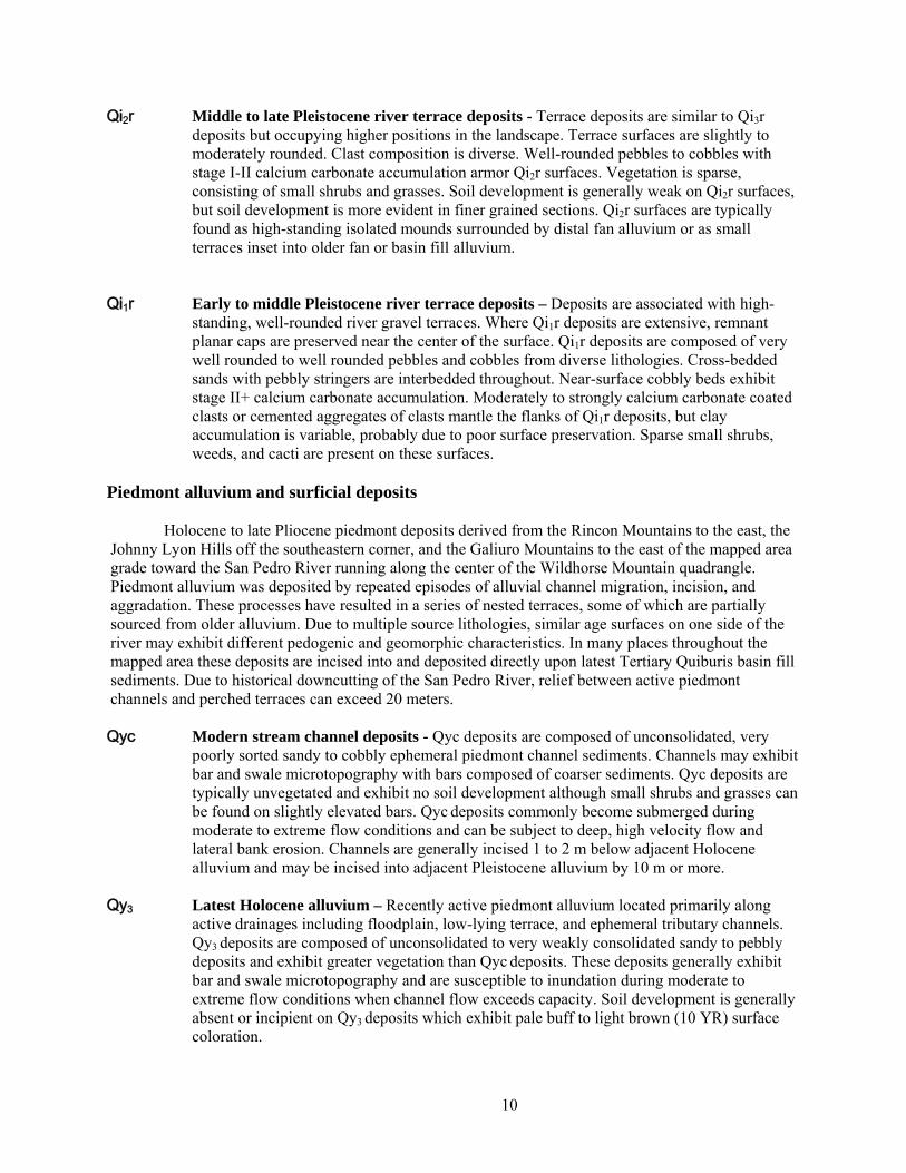
Qi2r Middle to late Pleistocene river terrace deposits - Terrace deposits are similar to Qi3r deposits but occupying higher positions in the landscape. Terrace surfaces are slightly to moderately rounded. Clast composition is diverse. Well-rounded pebbles to cobbles with stage I-II calcium carbonate accumulation armor Qi2r surfaces. Vegetation is sparse, consisting of small shrubs and grasses. Soil development is generally weak on Qi2r surfaces, but soil development is more evident in finer grained sections. Qi2r surfaces are typically found as high-standing isolated mounds surrounded by distal fan alluvium or as small terraces inset into older fan or basin fill alluvium.
Qi1r Early to middle Pleistocene river terrace deposits – Deposits are associated with high-
standing, well-rounded river gravel terraces. Where Qi1r deposits are extensive, remnant planar caps are preserved near the center of the surface. Qi1r deposits are composed of very well rounded to well rounded pebbles and cobbles from diverse lithologies. Cross-bedded sands with pebbly stringers are interbedded throughout. Near-surface cobbly beds exhibit stage II+ calcium carbonate accumulation. Moderately to strongly calcium carbonate coated clasts or cemented aggregates of clasts mantle the flanks of Qi1r deposits, but clay accumulation is variable, probably due to poor surface preservation. Sparse small shrubs, weeds, and cacti are present on these surfaces.
Piedmont alluvium and surficial deposits
Holocene to late Pliocene piedmont deposits derived from the Rincon Mountains to the east, the Johnny Lyon Hills off the southeastern corner, and the Galiuro Mountains to the east of the mapped area grade toward the San Pedro River running along the center of the Wildhorse Mountain quadrangle. Piedmont alluvium was deposited by repeated episodes of alluvial channel migration, incision, and aggradation. These processes have resulted in a series of nested terraces, some of which are partially sourced from older alluvium. Due to multiple source lithologies, similar age surfaces on one side of the river may exhibit different pedogenic and geomorphic characteristics. In many places throughout the mapped area these deposits are incised into and deposited directly upon latest Tertiary Quiburis basin fill sediments. Due to historical downcutting of the San Pedro River, relief between active piedmont channels and perched terraces can exceed 20 meters. Qyc Modern stream channel deposits - Qyc deposits are composed of unconsolidated, very
poorly sorted sandy to cobbly ephemeral piedmont channel sediments. Channels may exhibit bar and swale microtopography with bars composed of coarser sediments. Qyc deposits are typically unvegetated and exhibit no soil development although small shrubs and grasses can be found on slightly elevated bars. Qyc deposits commonly become submerged during moderate to extreme flow conditions and can be subject to deep, high velocity flow and lateral bank erosion. Channels are generally incised 1 to 2 m below adjacent Holocene alluvium and may be incised into adjacent Pleistocene alluvium by 10 m or more.
Qy3 Latest Holocene alluvium – Recently active piedmont alluvium located primarily along
active drainages including floodplain, low-lying terrace, and ephemeral tributary channels. Qy3 deposits are composed of unconsolidated to very weakly consolidated sandy to pebbly deposits and exhibit greater vegetation than Qyc deposits. These deposits generally exhibit bar and swale microtopography and are susceptible to inundation during moderate to extreme flow conditions when channel flow exceeds capacity. Soil development is generally absent or incipient on Qy3 deposits which exhibit pale buff to light brown (10 YR) surface coloration.
10
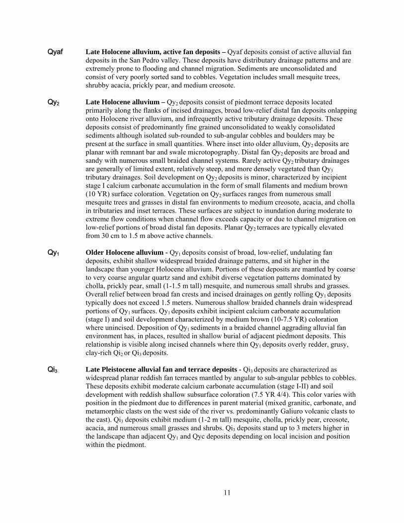
Qyaf Late Holocene alluvium, active fan deposits – Qyaf deposits consist of active alluvial fan deposits in the San Pedro valley. These deposits have distributary drainage patterns and are extremely prone to flooding and channel migration. Sediments are unconsolidated and consist of very poorly sorted sand to cobbles. Vegetation includes small mesquite trees, shrubby acacia, prickly pear, and medium creosote.
Qy2 Late Holocene alluvium – Qy2 deposits consist of piedmont terrace deposits located
primarily along the flanks of incised drainages, broad low-relief distal fan deposits onlapping onto Holocene river alluvium, and infrequently active tributary drainage deposits. These deposits consist of predominantly fine grained unconsolidated to weakly consolidated sediments although isolated sub-rounded to sub-angular cobbles and boulders may be present at the surface in small quantities. Where inset into older alluvium, Qy2 deposits are planar with remnant bar and swale microtopography. Distal fan Qy2 deposits are broad and sandy with numerous small braided channel systems. Rarely active Qy2 tributary drainages are generally of limited extent, relatively steep, and more densely vegetated than Qy3 tributary drainages. Soil development on Qy2 deposits is minor, characterized by incipient stage I calcium carbonate accumulation in the form of small filaments and medium brown (10 YR) surface coloration. Vegetation on Qy2 surfaces ranges from numerous small mesquite trees and grasses in distal fan environments to medium creosote, acacia, and cholla in tributaries and inset terraces. These surfaces are subject to inundation during moderate to extreme flow conditions when channel flow exceeds capacity or due to channel migration on low-relief portions of broad distal fan deposits. Planar Qy2 terraces are typically elevated from 30 cm to 1.5 m above active channels.
Qy1 Older Holocene alluvium - Qy1 deposits consist of broad, low-relief, undulating fan
deposits, exhibit shallow widespread braided drainage patterns, and sit higher in the landscape than younger Holocene alluvium. Portions of these deposits are mantled by coarse to very coarse angular quartz sand and exhibit diverse vegetation patterns dominated by cholla, prickly pear, small (1-1.5 m tall) mesquite, and numerous small shrubs and grasses. Overall relief between broad fan crests and incised drainages on gently rolling Qy1 deposits typically does not exceed 1.5 meters. Numerous shallow braided channels drain widespread portions of Qy1 surfaces. Qy1 deposits exhibit incipient calcium carbonate accumulation (stage I) and soil development characterized by medium brown (10-7.5 YR) coloration where unincised. Deposition of Qy1 sediments in a braided channel aggrading alluvial fan environment has, in places, resulted in shallow burial of adjacent piedmont deposits. This relationship is visible along incised channels where thin Qy1 deposits overly redder, grusy, clay-rich Qi2 or Qi3 deposits.
Qi3 Late Pleistocene alluvial fan and terrace deposits - Qi3 deposits are characterized as
widespread planar reddish fan terraces mantled by angular to sub-angular pebbles to cobbles. These deposits exhibit moderate calcium carbonate accumulation (stage I-II) and soil development with reddish shallow subsurface coloration (7.5 YR 4/4). This color varies with position in the piedmont due to differences in parent material (mixed granitic, carbonate, and metamorphic clasts on the west side of the river vs. predominantly Galiuro volcanic clasts to the east). Qi3 deposits exhibit medium (1-2 m tall) mesquite, cholla, prickly pear, creosote, acacia, and numerous small grasses and shrubs. Qi3 deposits stand up to 3 meters higher in the landscape than adjacent Qy1 and Qyc deposits depending on local incision and position within the piedmont.
11
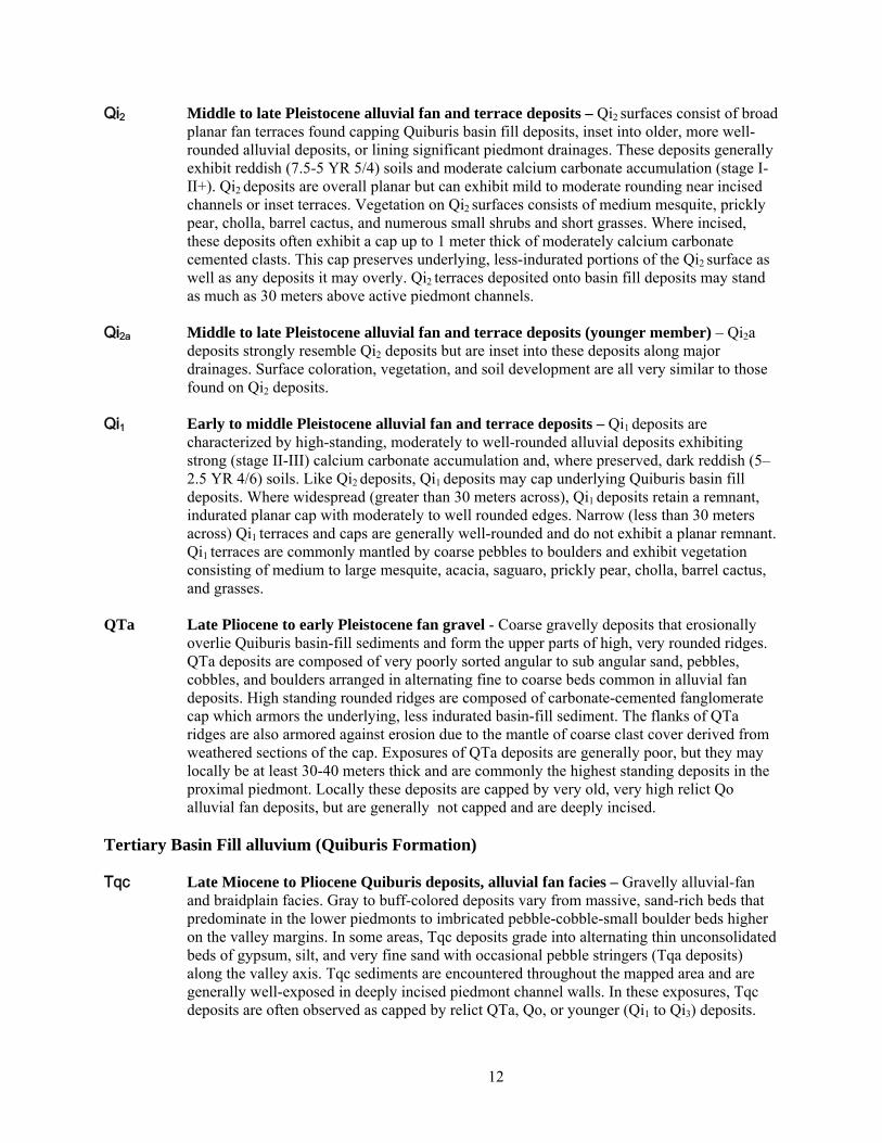
Qi2 Middle to late Pleistocene alluvial fan and terrace deposits – Qi2 surfaces consist of broad planar fan terraces found capping Quiburis basin fill deposits, inset into older, more well-rounded alluvial deposits, or lining significant piedmont drainages. These deposits generally exhibit reddish (7.5-5 YR 5/4) soils and moderate calcium carbonate accumulation (stage I-II+). Qi2 deposits are overall planar but can exhibit mild to moderate rounding near incised channels or inset terraces. Vegetation on Qi2 surfaces consists of medium mesquite, prickly pear, cholla, barrel cactus, and numerous small shrubs and short grasses. Where incised, these deposits often exhibit a cap up to 1 meter thick of moderately calcium carbonate cemented clasts. This cap preserves underlying, less-indurated portions of the Qi2 surface as well as any deposits it may overly. Qi2 terraces deposited onto basin fill deposits may stand as much as 30 meters above active piedmont channels.
Qi2a Middle to late Pleistocene alluvial fan and terrace deposits (younger member) – Qi2a
deposits strongly resemble Qi2 deposits but are inset into these deposits along major drainages. Surface coloration, vegetation, and soil development are all very similar to those found on Qi2 deposits.
Qi1 Early to middle Pleistocene alluvial fan and terrace deposits – Qi1 deposits are
characterized by high-standing, moderately to well-rounded alluvial deposits exhibiting strong (stage II-III) calcium carbonate accumulation and, where preserved, dark reddish (5–2.5 YR 4/6) soils. Like Qi2 deposits, Qi1 deposits may cap underlying Quiburis basin fill deposits. Where widespread (greater than 30 meters across), Qi1 deposits retain a remnant, indurated planar cap with moderately to well rounded edges. Narrow (less than 30 meters across) Qi1 terraces and caps are generally well-rounded and do not exhibit a planar remnant. Qi1 terraces are commonly mantled by coarse pebbles to boulders and exhibit vegetation consisting of medium to large mesquite, acacia, saguaro, prickly pear, cholla, barrel cactus, and grasses.
QTa Late Pliocene to early Pleistocene fan gravel - Coarse gravelly deposits that erosionally overlie Quiburis basin-fill sediments and form the upper parts of high, very rounded ridges. QTa deposits are composed of very poorly sorted angular to sub angular sand, pebbles, cobbles, and boulders arranged in alternating fine to coarse beds common in alluvial fan deposits. High standing rounded ridges are composed of carbonate-cemented fanglomerate cap which armors the underlying, less indurated basin-fill sediment. The flanks of QTa ridges are also armored against erosion due to the mantle of coarse clast cover derived from weathered sections of the cap. Exposures of QTa deposits are generally poor, but they may locally be at least 30-40 meters thick and are commonly the highest standing deposits in the proximal piedmont. Locally these deposits are capped by very old, very high relict Qo alluvial fan deposits, but are generally not capped and are deeply incised.
Tertiary Basin Fill alluvium (Quiburis Formation) Tqc Late Miocene to Pliocene Quiburis deposits, alluvial fan facies – Gravelly alluvial-fan
and braidplain facies. Gray to buff-colored deposits vary from massive, sand-rich beds that predominate in the lower piedmonts to imbricated pebble-cobble-small boulder beds higher on the valley margins. In some areas, Tqc deposits grade into alternating thin unconsolidated beds of gypsum, silt, and very fine sand with occasional pebble stringers (Tqa deposits) along the valley axis. Tqc sediments are encountered throughout the mapped area and are generally well-exposed in deeply incised piedmont channel walls. In these exposures, Tqc deposits are often observed as capped by relict QTa, Qo, or younger (Qi1 to Qi3) deposits.
12
Tqfr Pliocene Quiburis basin fill deposits, fanglomerate unit of Roble Canyon – Moderately indurated conglomerate at the southwest edge of basin-fill exposures in upper Roble Canyon and locally in Soza Canyon. These conglomerate exposures are typically slightly faulted and tilted, and could be somewhat older than other Quiburis exposures.
BEDROCK MAP UNITS Oligo-Miocene volcanic and sedimentary units Tsmv Conglomerate, San Manuel Formation, volcaniclastic Soza Canyon facies – Clasts are
derived primarily from volcanic rocks like those that make up most of the Galiuro mountains as well as locally exposed volcanic rocks beneath the conglomerate in lower Soza Canyon (Dickinson, 1991).
Tsmm Conglomerate, San Manuel Formation, metamorphiclastic Paige Canyon facies – Clasts
are derived primarily from metamorphic tectonites like those that form nearby bedrock in the Little Rincon Mountains (Dickinson, 1991).
Tvm Mafic volcanics of lower Soza Canyon (Oligo-Miocene) – Dark gray to black, somewhat
crystal poor lava-flow breccia and local flow cores. Thin-section examination (very fresh sample 3-7-07-1 from station JES-07-546) reveals ~10%, >2 mm plagioclase, and ~2-3%, <1 mm pyroxene(?), in black matrix with abundant, very fine acicular plagioclase. The high-relief tabular mineral, with up to second-order blue in polarized light, is inferred to be pyroxene and not hornblende because it is not pleochroic. Volcanics are 98% breccia, but clasts of mafic volcanics are generally rounded as if tumbled in a volcanic flow breccia. Matrix is indurated as if composed of lava rock or hot crushed rock. As seen in Soza Canyon wash bank, 2% of rock has platy fractures as if conforming to margins of lava flow core, and is not brecciated. All three features are support the interpretation of a volcanogenic origin for these rocks (not rock-avalanche breccia as interpreted by Dickinson and Shafiqullah, 1989, and Dickinson, 1991). This rock unit yielded a K-Ar date of 25.5±0.6 Ma from groundmass feldspar (Dickinson and Shafiqullah, 1989, sample UAKA 83-75).
q Vein quartz – Includes quartz-calcite vein with open-space filling textures on the southwest
flank of Cañada Atravesada. Calcite(?) blades dissolved out to form up to 2 cm voids bounded by quartz crystals. Vein is emplaced into contact zone at base of Oligo-Miocene sedimentary and volcanic sequence, and so is no older than Oligo-Miocene.
Taf Small-feldspar andesite porphyry (Oligo-Miocene) – Pale to medium brown to reddish
brown andesite porphyry that contains 4-10%, 1-3 mm plagioclase, and 1-3%, <2 mm hornblende. Common color banding is probably due to variable devitrification or to alternation along parallel fractures that are now healed. Foliation is defined by variations in resistance to weathering over 3-15 mm thicknesses. Contact with underlying andesite porphyry appears at one location to be a flow-base breccia.
Tap Andesite porphyry lava flows (Oligo-Miocene) – Medium to dark gray to dark brown,
generally massive lava flows with 10-50%, 3-30 mm, conspicuous, tabular, plagioclase phenocrysts (“Turkey-track porphyry” of Cooper, 1961). A sample of this unit, from upper Youtcy Canyon near west edge of the map area, yielded a K-Ar date of 26.9 ± 2.5 Ma from plagioclase (Shafiqullah et al., 1978).
13
Tapi Andesite porphyry intrusion (Oligo-Miocene) – Medium to dark gray to dark brown dikes
with 30-50%, 3-30 mm, tabular, plagioclase phenocrysts, some with gray interior and white rim (“Turkey-track porphyry” of Cooper, 1961). At one location (JES-07-040) a massive, very hard, undeformed dike of this unit intrudes deformed granitoids.
Tm Mafic lava flows (Oligo-Miocene) – Intermediate to mafic lava flows, aphyric to crystal
poor, with 1%, 1-5 mm black pyroxene. Unit is locally vesicular and is generally dark gray. Tmi Mafic intrusion (Oligo-Miocene) – Mafic lava similar to that in nearby flows of map unit
Tm here has steep irregular contact with intruded granite. Tmd Mafic dike (Oligo-Miocene) – At one location near the west edge of the Soza Canyon 7 ½'
Quadrangle (JES-07-283), this unit consists of plagioclase porphyry containing 25-35%, 1-3 mm plagioclase, and 5-7%, 1-2 mm hornblende.
Tt Ash-fall tuff (Oligo-Miocene) – At one location in Cañada Atravesada this unit consists of a
1-2 m thick, very fine grained tephra (JES-07-366). Tl Limestone of the Mineta Formation (Oligo-Miocene) – Medium gray, bedded limestone,
with oncolitic concretions(?). Ts Sandstone and siltstone of the Mineta Formation (Oligo-Miocene) – Coarse to fine
sandstone, sandy siltstone, and siltstone, locally with 0.2-2 m thick gypsiferous siltstone beds and 1-4 m thick limestone beds. Color is typically tan to medium brown. Sandstone, which makes up most of this unit, is typically poorly sorted but moderately well bedded, with beds typically 2-30 cm thick. Locally includes pebbly sandstone and rare conglomerate. A 1-m-thick gypsiferous mudstone bed with up to 50% gypsum is present in upper Cañada Atravesada (station JES-07-402). In the Mineta Ridge area, structural disruption on a scale of tens of meters appears to be due to slumping beneath blocks of overlying andesite porphyry of map unit Tap. In some areas west of Mineta Ridge (station JES-07-253), silty carbonate, calcareous sandstone, and limestone are variably siliceous and variably affected by brecciation that appears to have been diagenetic, not hydrothermal or tectonic. Chew (1962) reported that rhinoceros fossil fragments were found in the Mineta Formation, probably from this unit.
Tcg Conglomerate of the Mineta Formation (Oligo-Miocene) – Basal Tertiary conglomerate
dominated by granite clasts near its base with increasing fractions of other rock types up section. Color is dark to light brown to reddish brown. Exposures near Youtcy Canyon consist primarily of disaggregated granite that forms poorly sorted, pebbly arkosic sandstone and pebble to cobble conglomerate, with subordinate (up to 15%) clasts of mafic volcanic rocks, carbonate, and quartzite. Clasts are generally <25 cm but are locally as big as 50 cm diameter. Bedding varies from poorly defined by crude variations in clast size to moderately well defined by sharp boundaries separating fine and coarse clastic beds.
Td Dacite lava (Oligo-Miocene) – Intermediate composition volcanics with 5-7%, <3 mm
biotite, 15% feldspar, of which a small fraction is sanidine(?), and 1-2% oxidized pyrite(?). Unit is exposed over a small area southeast of Bar LY ranch where it forms a lens within tilted conglomerate.
14
Tr Rhyolite lava (Oligo-Miocene) – Quartz-biotite porphyry with locally fragmental texture. Volcanic-lithic fragments are not stretched or flattened. Uncertain if this is lava or pyroclastic unit. This unit is exposed discontinuously at the base of the tilted Tertiary section in Cañada Atravesada (Dickinson and Olivares, 1987). A whole-rock sample yielded a K-Ar date of 25.1 ± 0.55 Ma (Scarborough and Wilt, 1979, sample UAKA 78-33).
Non-tectonite map units, early Tertiary to Pennsylvanian TKm Mafic intrusive rocks in metamorphic tectonites and along shear zones (Tertiary to
Cretaceous) – Dark greenish gray, moderately to strongly chloritized, fine-grained, mafic intrusive rocks that occur in sheets within metamorphic tectonites at the north end of White Ridge, and along thrust faults placing muscovite granite on Bisbee group in the same area. Fine to very fine-grained, with largely undiscernible mineralogy most likely consisting of chlorite, green biotite, albitic plagioclase, and less abundant quartz, epidote and opaque minerals.
Kbs Sandstone, Bisbee Group (upper Jurassic to middle Cretaceous) – Mostly medium to
fine grained, quartz-rich sandstone. Includes silty, fine-grained sandstone, siltstone, calcareous siltstone, and conglomerate with subrounded quartzite clasts up to 10 cm diameter.
KJb Bisbee Group, undivided (Cretaceous to Jurassic) – Carbonate, siltstone, sandstone, and
conglomerate of the Bisbee Group, undivided. Much of the exposures of this unit, which form the footwall block of a thrust fault and part of the hanging-wall block of the San Pedro detachment fault, were mapped and described by Lingrey (1982) as consisting almost entirely of poorly bedded to massive, matrix-supported, cobble to boulder conglomerate with less abundant light brown, calcite-cemented, quartzose sandstone and red shale with local cross bedding and scour and fill structures. The unit is lithified but not obviously metamorphosed. Clasts were derived largely from upper Paleozoic carbonates and, less commonly, quartzites. The matrix consists largely of sands well cemented by carbonate (Lingrey, 1982). This unit was not included with the Glance Conglomerate because large areas mapped by JES and SMR consist of sandstone with little or no conglomerate.
Jg Glance Conglomerate member of the Bisbee Group (Jurassic) –Most of the exposures of
this unit, which form the footwall block of a thrust fault and part of the hanging-wall block of the San Pedro detachment fault, were mapped and described by Lingrey (1982) as consisting almost entirely of poorly bedded to massive, matrix-supported, cobble to boulder conglomerate with less abundant light brown, calcite-cemented, quartzose sandstone and red shale with local cross bedding and scour and fill structures. The unit is lithified but not obviously metamorphosed. Clasts were derived largely from upper Paleozoic carbonates and, less commonly, quartzites. The matrix consists largely of sands well cemented by carbonate (Lingrey, 1982).
*Pe Earp Formation of the Naco Group (Pennsylvania to Permian) – Interbedded fine
grained quartzose sandstone and variably silty to pure limestone (mapped by Lingrey, 1982). Tectonite map units, Mesozoic and Paleozoic protoliths
15
Jgt Glance Conglomerate member of the Bisbee Group, tectonite (Jurassic protolith) – Tectonite derived from carbonate-matrix conglomerate and sandstone, with elongated siliceous clasts.
}|s Greenschist (Mesozoic to Paleozoic protolith) – Schist with both metasedimentary and
metaigneous protoliths. Phyllite to very fine grained metasandstone, sparse marble lenses, and fine-grained metagranitoids. Unit has strong foliation that could be transposed bedding. Green color is due to abundant fine chlorite.
}|qt Quartzite tectonite (Mesozoic to Paleozoic protolith) }|t Metasedimentary tectonite, undivided (Mesozoic to Paleozoic protolith) – In Espiritu
Canyon this unit includes (1) tectonically interlayered, pale greenish gray, fine grained to very fine grained, calcareous metasandstone and tan, recess forming marble, thinly interlayered on scale of generally less than 3 cm, (2) medium to dark gray phyllite to phyllitic, very fine grained metasandstone, and (3) pale gray, very fine grained quartzite. (4) Undifferentiated marble tectonite. (4) Several-meter-thick pebbly sandstone and conglomerate. In this conglomerate quartz granules and pebbles are flattened with typical aspect ratios of approximately 2:5. This unit is in contact with overlying granite along contact that is interpreted as an overturned disconformity (the basal conglomerate is identified as a marker bed on the map).
P*eht Tectonite derived from Horquilla Limestone and Earp Formation, undivided
(Pennsylvanian to Permian protolith) – Interbedded marble and calc-silicate (Lingrey, 1982).
*hMet Marble tectonite derived from Horquilla Limestone and Escabrosa Limestone,
undivided (Mississippian to Pennsylvanian protolith) – Typically calcite marble and slightly siliceous calcite marble (mapped by Lingrey, 1982).
Dm_at Tectonite derived from Martin Formation and Abrigo Formation, undivided (Devonian
and Cambrian protoliths) – Calcite and dolomite marble and variably siliceous marble and calc-silicates (mapped by Lingrey, 1982).
_Yqt Dripping Spring Quartzite and Bolsa Quartzite, undivided, tectonite (Middle
Proterozoic and Cambrian protoliths) – Chimney Canyon klippe, southwest Espiritu Canyon KJst Sandy and conglomeratic tectonite derived from Bisbee Group (Jurassic to Cretaceous
protolith) – This unit includes the following lithologies: (1) Carbonate and siliceous carbonate tectonite with subrounded clasts of siliceous, fine-grained quartzite cobbles up to 10 cm diameter. (2) Carbonate tectonite with thin layers containing abundant sand grains that are not well sorted nor rounded and that could only have been derived from the Bisbee Group (Paleozoic and Proterozoic units contain more mature sands). (3) Fine grained quartzite, generally light gray, with slightly darker laminations and weathering that reveal bedding. Locally, quartzite is associated with phyllite. (4) Dark gray quartzite/psammite with granules up to 5 mm diameter (flattened to 2 x 10 mm). (5) Conglomerate that forms beds or amalgamated beds up to perhaps 5 m thick, with quartzite clasts locally up to 50 cm diameter (flattened to 2:1 aspect ratio is typical).
16

|cut Carbonate tectonite derived from upper Paleozoic limestone and dolostone (upper Paleozoic protolith) – This unit includes the following lithologies: (1) Silty and very fine grained sandy, laminated calcite marble tectonite, in some areas with sparse to abundant protruding siliceous stringers and nodules. (2) Pale grayish white, tannish white, and pinkish tan, calcite marble tectonite with very sparse siliceous layers (<2 cm) and knots. This marble tectonite seems too pure to be Mesozoic carbonate and is most likely derived from Mississippian Escabrosa Limestone or Pennsylvanian Horquilla Limestone. (3) Pale gray to pale whitish gray carbonate with variations in weathering that reveal thinly layered to laminated character (1-10 mm). Some thin beds contain up to 20-40% very fine sand grains, but concentration is more typically 1-3%. Sparse lenses of pure quartz sand are also present.
Tertiary to Proterozoic crystalline-rock map units Tgl Heterogeneous pegmatitic leucogranite (Eocene) – Leucogranite that varies from highly
heterogeneous and pegmatitic to medium- to fine-grained muscovite granite, to very fine grained leucofelsite.
TXh Hornblendite (Paleoproterozoic to Tertiary) – This unit consists of 85-90%, 2-10 mm
hornblende and interstitial plagioclase. Pale green mineral is probably epidote but could be pyroxene. Unit forms one small outcrop in upper Youtcy Canyon (station JES-07-308) that is just west of the west edge of the Soza Canyon 7 ½′ Quadrangle.
TXm Fine-grained, mafic biotite granitoid (Paleoproterozoic to Tertiary) – All grains are <1
mm diameter. This dark greenish-gray map unit, which contains abundant biotite, is exposed in upper Youtcy Canyon west of the west edge of the Soza Canyon 7 ½′ Quadrangle.
YXg Biotite granite, undivided (Paleoproterozoic or Mesoproterozoic) – Includes the
following: (1) Extensive exposures of “porphyritic biotite quartz monzonite to granodiorite” mapped by Lingrey (1982) in the footwall of the San Pedro detachment fault. This unit was correlated with the Continental Granodiorite by Drewes (1974; see also Silver, 1978). Lingrey (1982, p. 22) further described the granite as “predominantly quartz monzonitic (adamellitic) to rarely granodioritic” with “feldspar crystals (usually K-feldspar, but sometimes oligoclase)...set in a coarse-grained hypidiomorphic-granular fabric. Clump-like aggregates of biotite create a characteristic mottled appearance.” Lingrey (p. 22) also noted that “Locally, and particularly near the contact with the overlying metasedimentary tectonites, a strong gneissic to mylonitic foliation indicates the presence of some synmetamorphic deformation.” (2) Medium-grained, variably porphyritic biotite granite in the area around Big Tank at the west edge of the Soza Canyon Quadrangle and including the eastern edge of the adjacent Piety Hill Quadrangle. K-feldspar phenocrysts, up to 3 cm long, make up 5-10% of rock unit. Mafic minerals, which make up 10-15% of unit, consist in part of fine felted biotite. (3) Equigranular, medium-grained granite, containing 3-6% mafics (biotite?), that is located directly below the San Pedro detachment fault at the west edge of the Soza Canyon Quadrangle. This granite seems too equigranular and felsic to be part of the adjacent granite around Big Tank, but alteration is so severe in the footwall of the San Pedro detachment fault that this distinction is uncertain. Furthermore, the contact separating this granite from the granite of Big Tank was not clearly identified.
YXgm Porphyritic two-mica granite (Paleoproterozoic or Mesoproterozoic) – Coarse-grained,
two-mica granite, with 1-3%, 1-2 mm muscovite, 5-10%, 2-8 mm clots of biotite, and tabular, red K-feldspar up to 4 cm long. This unit also contains pale greenish gray
17
plagioclase, and quartz, with roughly equal percentages of quartz, plagioclase, and K-feldspar.
YXgma Leucogranitic phase of porphyritic two-mica granite (Paleoproterozoic or
Mesoproterozoic) – This unit is inferred to be related to the adjacent porphyritic two-mica granite (map unit YXgm) because K-feldspar is reddish, unlike Eocene pegmatitic leucogranite (map unit Tgl) in the footwall of the San Pedro detachment fault which is white because it contains so little iron.
Xgj Johnny Lyon granodiorite (Paleoproterozoic) – Medium-grained biotite granite with
blocky, 1-4 cm long, K-feldspar megacrysts that make up 10-25% of the rock unit, and ~5-10% mafic minerals, most of which are probably biotite but are generally too altered for definitive identification.
Xp Pinal Schist (Paleoproterozoic) – Very fine grained quartz-mica schist.
REFERENCES CITED Chew, R.T., 3rd, 1962, The Mineta Formation, a middle Tertiary unit in southeastern Arizona: Arizona
Geological Survey Digest 5, p. 35-44. Cooper, J.R., 1961, Turkey-track porphyry--a possible guide for correlation of Miocene rocks in
southeastern Arizona: Arizona Geological Society Digest, v. 4, p. 17-33. Dickinson, W.R., 1991, Tectonic setting of faulted Tertiary strata associated with the Catalina core complex
in southern Arizona: Geological Society of America, Special Paper 264, 106 p. Dickinson, W.R., and Olivares, M.D., 1987, Reconnaissance geologic map of Mineta Ridge and Banco
Ridge area, Pima and Cochise counties, Arizona: Arizona Geological Survey Miscellaneous Map MM-87-C, scale 1:24,000, with 3 p. text.
Dickinson, W.R., and Shafiqullah, M., 1989, K-Ar and F-T ages for syntectonic mid-Tertiary volcano-sedimentary sequences associated with the Catalina core complex and San Pedro trough in southern Arizona: Isochron/West, n. 52, p. 15-27.
Drewes, H., 1974, Geologic map and sections of the Happy Valley Quadrangle, Cochise County, Arizona: U.S. Geological Survey Miscellaneous Investigations Series Map I-832, scale 1:48,000.
Hereford, R., 1993, Entrenchment and widening of the upper San Pedro River, Arizona: Geological Society of America Special Paper 182, 46 p.
Huckleberry, Gary, 1996, Historical channel changes on the San Pedro River, southeastern Arizona: Arizona Geological Survey Open-File Report 96-15, 35 p.
Lingrey, S. H., 1982, Structural geology and tectonic evolution of the northeastern Rincon Mountains, Cochise and Pima Counties, Arizona: Tucson, University of Arizona, unpublished Ph.D. thesis, 202 p.
Scarborough, R.B., and Wilt, J.C., 1979, A study of uranium favorability of Cenozoic sedimentary rocks, Basin and Range province, Arizona - Part I. General geology and chronology of pre-late Miocene Cenozoic sedimentary rocks: Tucson, Arizona Bureau of Geology and Mineral Technology Open-File Report 79-1, 101 p.
Shafiqullah, M., Damon, P. E., Lynch, D. J., Kuck, P. H., and Rehrig, W. A., 1978, Mid-Tertiary magmatism in southeastern Arizona, in Callender, J. F., Wilt, J.C., and Clemons, R.E., eds., Land of Cochise: Socorro, New Mexico Geological Society 29th Field Conference Guidebook, p. 231-241.
Silver, L.T., 1978, Precambrian formations and Precambrian history in Cochise County, southeastern Arizona, in Callender, J. F., and others, eds., Land of Cochise: Socorro, New Mexico Geological Society, 29th Field Conference Guidebook, p. 157-163.
18

Wood, M.L., 1997, Historical channel changes along the lower San Pedro River, southeastern Arizona: Arizona Geological Survey Open-File Report 97-21, 44 p., 3 sheets, scale 1:24,000.
19