Embed Size (px)
Citation preview
Geologic map of the Sawtooth Mountains and the north end of the West Silver Bell Mountains,
Pinal and Pima Counties, southern Arizona
by
Charles A. Fergusonl, Wyatt G. Gilbere, Jeanne E. Klawon2
, Philip A. Pearthreel, and Lisa Peters3
Arizona Geological Survey Open-File Report 99-16
August, 1999 Revised September, 2000
Arizona Geological Survey 416 W. Congress, Suite 100, Tucson, AZ 85701
Includes 27 page text, 1:24,000 scale geologic map (1 sheet)
Jointly funded by the Arizona Geological Survey and the United States Geological Survey STATEMAP Program,
Contract # 98HQAG2064
This report is preliminary and has not been edited or reviewed for conformity with Arizona Geological Survey standards
1 Arizona Geological Survey 2 US Bureau of Reclamation, PO Box 25007, Mail Code 8330, Denver, Colorado 80225 3 New Mexico Geochronological Research Laboratory, 801 Leroy Place, Socorro, NM 87801


Introduction The Sawtooth Mountains are a small (45 km2
), low-relief (250 m), yet rugged range composed of essentially flat-lying, Mid-Tertiary volcanic rocks. Along with the West Silver Bell Mountains, which consist mostly of Middle Proterozoic granitic rocks, the ranges form the southwestern boundary ofthe Picacho basin, a major north-trending, approximately 20 km-wide, 3 l<m-deep basin in the Basin and Range structural province of southern Arizona.
Access on paved roads is possible from Interstate 10, taking Sunland Gin Road about 20 km south to within few kilometers ofthe Sawtooth Mountains. From this point, four-wheel drive vehicles are required to negotiate the crossings of sandy washes on all roads that lead into the mountains. The east slope of the range is steep and rugged, but the west side is very gentle, with older Quaternary fan surfaces extending to within a kilometer of the ridge crest in some areas. Road access within the range is fairly extensive, but the main east-west road through the middle includes a very steep climb on the east slope that is impassable to practically all conventional fourwheel drive vehicles.
Previous Work
1
The Sawtooth Mountains are mentioned frequently in mineral resource, geophysical, and soil surveys of southern Arizona dating back to the early 20th century, but these reports provide little information about the stratigraphy or structure of the mountains or the nature of its surficial deposits. The geology of the Sawtooth Mountains is portrayed in a very generalized fashion on the Pinal County geologic map (Wilson and Moore, 1959). Bergquist and others (1978) and Blacet and others (1978) conducted a reconnaissance study ofthe area and produced bedrock geologic maps of the Eloy and Silver Reef Mountains 15' quadrangles which includes the Sawtooth Mountains, and parts of the West Silver Bell Mountains. Banks and others (1978) published one chemical analysis, and one K-Ar age date. Hanis (1994) investigated the eastern piedmont areas ofthe ranges and produced an earth fissure map. The only pre-existing map of surficial deposits in the area is a reconnaissance study (Pearthree and others, 1988).
Acknowledgments Geologic mapping of the Sawtooth Mountains was funded by STATEMAP research grant
#98HQAG2064 to the Arizona Geological Survey. We thank Jon Spencer, Ray Harris, and Steve Richard for helpful discussions, and Larry Fellows for consistent support of geologic mapping.
Quaternary Geology Methodology
The project area was mapped using two sets of aerial photographs, and limited field mapping and observations of soils. The piedmont areas were mapped primarily using 1 :40,000 scale black and white U. S. Geological Survey aerial photos from 1992, augmented by 1:60,000 Army Map Service aerial photos from 1953. Piedmont areas were field checked on a reconnaissance basis by Jeanne Klawon, with assistance and suggestions from Philip Pearthree.
The physical characteristics of alluvial surfaces (channels, alluvial fans, floodplains, and stream terraces) were used to differentiate their associated deposits by age. These physical characteristics are summarized in Table 1. Alluvial surfaces of similar age have distinctive appearance and soil characteristics because they have undergone similar post-depositional modifications. Young (less than a few thousand years old) alluvial-fan surfaces, for example, still retain clear evidence of the original depositional topography, such as bars of

2 coarse deposits, swales (trough-like depressions) where low flows passed between bars, and
distributary channel networks, which are characteristic of active alluvial fans. Young fan surfaces also show minimal development of soil, desert pavement, and rock varnish and are basically undissected. Very old fan surfaces, in contrast, have been isolated from substantial fluvial deposition or reworking for hundreds of thousands of years. These surfaces are characterized by strongly developed soils with clay- and calcium carbonate-rich horizons, welldeveloped tributary stream networks that are entrenched 1 to 10m below the fan surface, and strongly developed varnish on surface rocks. Old alluvial-fan surfaces may also have smooth, closely packed desert pavements between the entrenched drainages. The ages of alluvial surfaces in the southwestern United States may be roughly estimated based on these surface characteristics, especially soil development (Gile and others, 1981; Bull, 1991).
In this map, surficial deposits are subdivided based on their depositional environment (rivers and large washes, smaller tributary washes on piedmonts, wind activity, hillslope processes) and estimated age of deposits. Surface and soil characteristics were used to correlate alluvial deposits and to estimate their ages. Following field checking, geologic mapping was compiled on 7.5' USGS topographic maps in preparation for final map production.
Geomorphic Framework The landscape of the map area consists of small, low-lying mountain ranges and broad,
minimally dissected basins that are typical of the Sonoran Desert subprovince. Bedrock exposures are limited to these mountain ranges and a few outlying knobs (inselbergs) that rise above the basin floors and broad plains surrounding the mountain ranges. Most of the map area is covered by late Quaternary alluvium that was deposited by the Santa Cruz River and the many smaller tributary washes that drain the region. The surficial geology and geomorphology of this area record the gradual transfer of material from the mountains to the surrounding piedmonts and basin floors during the past few million years in the absence of significant tectonic activity. The geomorphology and surficial geology of the Sawtooth Mountains and vicinity record its recent geologic evolution. The broad, undissected basin-floor areas covered with young deposits reflect the slow, long-term aggradation of the Santa Cruz River drainage system. Wide floodplains are Holocene deposits of sand, silt and clay, with local gravel. Multiple, small, discontinuous channels were typical, and well-defined channels were probably unusual, prior to human alteration of the floodplain for agricultural purposes. In the modem environment, most channels have been artificially confined between earthen berms to contain low and moderate flows through much of the basin (Rhoades, 1991). During large historical floods of the latter part of this century, however, broad portions of the basin floor were inundated (see Roeske and others, 1989; Wood and others, in review). Because of the construction of Greene Canal in the early 1900's and the subsequent evolution of the Santa Cruz River system, Greene Wash has become the major flow path for the Santa Cruz River as it flows into the Santa Cruz flats area (see Roeske and others, 1989; Wood and others, 1999; Klawon and others, 1998). The low stream gradients and minimal topographic relief on the basin floors facilitated these changes in channel positions and flow paths.
Piedmonts of the map area are covered by alluvial and eolian deposits, which vary widely in age. Upper piedmont areas typically have tributary (converging downstream) drainage systems. These areas contain alluvial surfaces that range in age from Holocene to early Pleistocene. Topographic relief between active channels and adjacent relict alluvial fan surfaces is highly variable, ranging from a few meters or less to greater than 5 meters. There is

3 substantial variation in the extent of young and old alluvial surfaces on upper piedmont areas. This may depend on local base-level changes that cause stream entrenchment. Lower piedmonts have complex distributary (diverging downslope) and tributary drainage networks. Topographic relief is minimal; channels are entrenched less than 2 m below adjacent alluvial surfaces. Pleistocene and Holocene-Pleistocene deposits cover broad portions of the middle and lower piedmonts. Where Holocene-Pleistocene deposits are present, the veneer of Holocene deposits is generally quite thin. Based on the age and distribution of surfaces, Holocene deposition has been comparatively less than Pleistocene deposition.
The topographic fronts of the mountains are very embayed and sinuous, and outlying inselbergs are common. The steep mountain slopes with limited cover of colluvium attest to the predominance of erosional processes over in situ weathering in the modern environment. Uncommon but intense rainfall and runoff, steep slopes, and sparse vegetative cover facilitate erosion. It is likely that significantly more hillslope colluvium covered bedrock slopes in the mountains during glacial pluvial intervals of the Quaternary, especially in ranges such as the West Silver Bell Mountains that are composed of granitic or metamorphic rocks (Bull, 1991). The dramatic glacial-interglacial cycles of the Pleistocene probably resulted in periods of accumulation of colluvium and erosion of colluvium that are recorded as alluvial fans and fan remnants on the piedmonts. Analysis of packrat middens indicates that the climate similar to today has only existed since about 4 ka (Van Devender, 1990). Late Pleistocene midden samples from the Sonoran Desert contain fragments of juniper, pinyon pine, and Joshua tree, indicating cooler summers and a greater proportion of winter precipitation than today. Precipitation probably reached a maximum during the late Pleistocene (30 to 15 ka), and precipitation falling during winter months would have infiltrated more deeply than summer moisture due to lowered evaporation rates. Due to the increased effectiveness of leaching and equable temperatures, as well as the increased proportion of winter rain, late Pleistocene climate was apparently more conducive to weathering of minerals and accumulation of colluvium on hillslopes than the modern interglacial moisture regime. Much of this Pleistocene colluvium may have been flushed onto the surrounding piedmonts in the past 10,000 to 15,000 years, resulting in the deposition of the broad, thin mantle of Holocene alluvium that covers the piedmont areas in the West Silver Bell Mountains.
Tertiary stratigraphy Volcanic rocks of intermediate composition dominate the Sawtooth Mountains volcanic
field. Neither the top nor bottom of the volcanic pile is preserved, but the map pattern to the south suggests that the unconformity with crystalline basement is not far below the oldest volcanic rock. An early Miocene age for the rocks is based on our single-crystal, laser fusion 40 ArP9 Ar date of 22.64 ± 0.05 Ma from the crystal-rich trachyte lava (map unit Ttx) along the western edge of the study area. The distribution of ages for sample F9-121 (Figure 5, Table 5) is somewhat bimodal but this distribution is probably due to the limited number of crystals analyzed rather than two actual populations. The KlCa ratios, radiogenic yields and signal sizes show no systematic variations between the two clusters. It is likely that this apparent bimodality would disappear if additional crystals were analyzed. For this reason, we have used all analyzed crystals ofF9-121 to calculate a weighted mean age. The age of22.64 ± 0.05 Ma has a MSWD value greater than the acceptable level so the error has been adjusted. A KI Ar plagioclase date of 25.9 + 1.0 Ma (Banks and others, 1978) from the trachyte of Indian Head, one of the youngest units in the field is possibly to old.

4 The preserved thickness of volcanic rocks is on the order of500 to 600 meters.
The volcanic rocks are essentially flat lying, and only one major fault was identified, a NWstriking, southwest-side-down fault that transects the middle of the range. The area's oldest and youngest rocks are exposed on either side of this fault near its southeastern limit of exposure, and this permits a nearly complete section of the volcanic field to be seen in a relatively small area. Some of the volcanic units are recognized only on one side of this fault. A generalized stratigraphic cross-section (Figure 1) depicts all known stratigraphic relationships in the mountain range.
The gentle western slope of the range is underlain by pedimented bedrock consisting of volcanic units that interfinger with a conglomerate unit (Tc) that contains a wide variety of clast types. Outcrops of the conglomerate unit are rarely exposed, but at these exposures, sedimentology of the strata suggests a fluvial depositional environment. To the west, the conglomerate grades into an essentially non-volcaniclastic lithofacies containing clasts of quartzite, limestone, granitoid, and porphyry (Figure 1). These clast lithologies suggest a source area to the south or west because the porphyry clasts are reminiscent of some of the Laramide-aged stocks and dikes in the southerly adjacent Silver Bell Mountains. In addition, Paleozoic rocks are exposed in ranges to the south and west, but essentially absent to the north or east. To the east, the conglomerate grades into lava breccia and coarse-grained, monomict volcaniclastic rocks associated with subjacent volcanic units (principally Ttx, but also Tti, and Tbu). Intermediate varieties of the conglomerate unit (Tc) contain mixtures of volcanic and non-volcanic clasts. The eastern pinch-out of the conglomerate unit is defined as the eastern limit of non-volcanic clasts. Monomict volcaniclastic conglomerate and coarse-grained epiclastic breccias are widespread lithologies within the crystal-rich trachyte lava unit (Ttx) in the northern part of the range, but a reliable map depicting all of these rocks would be very time-consuming to produce. A probable mammalian track-way is preserved in a sequence of pebbly sandstone within the Ttx unit in the northern part of the range (Figure 2).
Geochemistry and petrology 22 samples of volcanic rocks from the Sawtooth Mountains were analyzed for major and
trace elements at New Mexico Bureau of Mines and Mineral Resources geochemistry laboratory. The locations of these samples are indicated on Sheet 1 and on Table 3. The samples were crushed in a steel jaw crusher, split, and ground in a Tema mill using a we grinding set. The samples were fused into glass disks and analyzed on a Phillips wavelength dispersive x-ray fluorescence spectrometer for major elements. A separate split of each sample was used to determine the losson-ignition gravimetrically. Trace elements were determined with pressed powder pellets.
Geochemistry of representative units in the Sawtooth Mountains (Figure 3, Table 2,3) show a range of compositions from rhyolite to basaltic andesite using the chemical classification scheme ofLe Bas and others (1986). Also included in Figure 3 is another analysis of the trachyte ofIndian Head from a southeastern outlier in the Tator Hills (Banks and others, 1978). Many of the units that were mapped using field names such as dacite or andesite are actually trachyte or trachyandesite, and five of the pyroxene, ± olivine-bearing mafic lavas that were mapped using the field name "basalt" are actually basaltic andesite, basaltic trachyandesite, or trachyandesite (Tat, Tba, Tb, Tbl, and Tbu). The chemistry of the Sawtooth Mountains volcanic rocks compares closely with the chemistry of the volcanic rocks in the nearby Samaniego Hills (Eastwood, 1970).
16 thin-sections of representative units were studied. The locations of the samples are indicated on Sheet 1. Petrographic information from these sections is integrated into our

unit descriptions. Two of the volcanic units contain sanidine phenocrysts (samples F9-121, and WG-161) and have potential for high-precision 40 ArP9 Ar age dating. All geochemical, petrographic, and potential geochronology samples are available for inspection at the Arizona Geological Survey offices in Tucson.
Structure
5
The structure of the Sawtooth Mountains is very simple. The only major fault is steeply southwest-dipping, and shows normal offset of the volcanic units. Subsidiary, antithetic, steeply northeast-dipping faults were identified at one locality (where the main fault dips 72 degrees to the southwest in the SW 114 sec. 27, R. 6 E., T. 9 S.), and the main strand at this locality also shows evidence of dextral, rei del shears.
The steep eastern front of the Sawtooth Mountains probably represents a buried, highangle, east-side-down normal fault, but since we do not have any information to constrain its location we do not show it on the map. Just to the east of the range front, a complex pattern of north-striking earth fissures (Harris, 1994) indicate rapid easterly thickening of basin-fill in this area. Water well driller's records (Hardt and others, 1964) indicate that for wells within 3 or 4 km of the range front, depths to bedrock range between 285 and 365 meters (900' -1200').
Driller's records (Hardt and others, 1964) of water wells to the northeast of the West Silver Bell Mountains indicate that basin-fill is at least 300 meters thick (1,000') within a few kilometers of the range. The northwestern piedmont of the West Silver Bell Mountains, however, is underlain by pedimented granite that is exposed in a few places, and a few low-lying hills composed of volcanic rock are present in the valley between the West Silver Bell Mountains and the Sawtooth Mountains. This implies that basin-fill is not very thick in this valley, and that the contact between the Middle Proterozoic granite (Y g) of the West Silver Bell Mountains and the southernmost volcanic rocks of the Sawtooth Mountains is a gently northwest-dipping unconformity (crosssection B-B', Sheet 1). A minor, concealed, northeast-striking fault is shown along the southeastern front of the Sawtooth Mountains because a small exposure of the aphyric trachyandesite (Tat), the youngest unit in the volcanic field, is present in relatively close juxtaposition with some of the older lavas (Tbl and Ttax) (Sheet 1).
Mineralization Significant mineralization was noted in two areas. At the eastern outcrop limit of the main
fault in the NE 114 sec. 34, R. 6 E., T. 9 S., prospect pits and minor workings are developed in fault breccia invaded by quartz, calcite, pyrolusite-coated veins and fracture-filling vugs. Other prospect pits in similar pyrolusite-coated breccia are present just to the south along the eastern front of the range (in the SE 1/4, sec. 34). In the northern part of the range pyrolusite veinlets were observed at prospect pits in the south-central part of section 16 and along the major fault in the NE 114 sec. 17, R. 6 E., T. 9 S. These northern occurrences also appear to be associated with fault zones and fault breccia.
Regional correlation The chemistry and petrography of the volcanic rocks in the Sawtooth Mountains is very
similar to rocks in the nearby Samaniego Hills (Eastwood, 1970; Ferguson and others, 1999). Rocks in the Sawtooth Mountains are only slightly more felsic on average (Figure 3), and all of these rocks are petrographically similar to rocks in the northerly adjacent Picacho Peak area (Briscoe, 1967; Shafiqullah and others, 1976; Richard and others, 1999). Alteration and

6 K-metasomatism (Brooks, 1986) has severely changed the chemical composition of most of the
rocks in the Picacho Peak area. The petrography and the general stratigraphic sequence of crystalpoor mafic-intermediate lavas bracketing a sequence of crystal-rich dacitic to trachytic lavas is common to all three mountain ranges, and it is very likely that the three ranges represent a single, tectonically dismembered volcanic field. The greatest thickness of volcanic rocks is preserved at Picacho Peak (between 1.5 and 2 krn), possibly because this area was the most active in terms of tectonic subsidence. Very coarse-grained granitic clasts, present throughout the Picacho Peak volcanic sequence, suggest a nearby source area composed of crystalline basement. Crystalline basement is exposed directly underlying the volcanic rocks in the Samaniego Hills, and is inferred to directly underlie the volcanic rocks in the Sawtooth Mountains, but no top of the volcanic sequence is preserved in any of the ranges. Minimum thickness of volcanic rocks in the Samaniego Hills is on the order of600 meters (Ferguson and others, 1999).
A hypothetical, reconstructed Sawtooth-Samaniego-Picacho volcanic field (Figure 4) portrays a northeast-thickening sequence of volcanic rocks. The volcanic rocks are interpreted to have overlapped a steeply southwest-dipping buttress unconformity to the northeast, which may represent the precursor to the Picacho Mountains detachment fault. The presence of coarse-grained granitoid-clast conglomerate, and slide blocks of granitoid up to 300 m long throughout the Picacho Peak volcanic sequence is the main evidence for such a structure.
The non-volcaniclastic, fluvial sedimentary rocks present in the Sawtooth Mountains and Samaniego Hills, are interpreted as deposits of a throughgoing fluvial. system derived from areas to the south where it appears the volcanic rocks pinched out onto a highland composed of Proterozoic crystalline rocks, Paleozoic sedimentary rocks, and Laramide-aged volcanic and hypabyssal rocks.

7 References Banks, N. G., Dockter, R D., Silberman, M. L., and Naeser, C. W., 1978, Radiometric ages of some
Cretaceous and Tertiary volcanic and intrusive rocks in south-central Arizona: United States Geological Survey Journal of Research, v. 6, p. 439-445.
Bergquist, l R, Banks, N. G., and Blacet, P. M., 1978, Reconnaissance geologic map of the Eloy quadrangle, Arizona: U. S. G. S. Miscellaneous Field Studies Map MF-990, 1 sheet, scale 1:62:500.
Blacet, P. M., Bergquist, l R, and Miller, S. T., 1978, Reconnaissance geologic map ofthe Silver Reef Mountains quadrangle, Arizona: U. S. G. S. Miscellaneous Field Studies Map MF-934, 1 sheet, scale 1 :62,500.
Briscoe, J. A., 1967, The general geology of the Picacho Peak area, unpublished M. S. thesis: Tucson, University of Arizona, 52 pp., 2 sheets.
Brooks, W. E., 1986, Distribution of anomalously high K20 volcanic rocks in Arizona: Metasomatism at the Picacho Peak detachment fault: Geology, v. 14, p. 339-342.
Bull, W.B., 1991, Geomorphic Response to Climatic Change, New York: Oxford University Press, 326 pp.
Eastwood, R L., 1970 A geochemical-petrological study of mid-Tertiary volcanism in parts of Pima and Pinal Counties, Arizona: Tucson, University of Arizona, unpublished Ph.D. dissertation, 212 pp.
Ferguson, C. A, Gilbert, W. G., Orr, T. R, Spencer, l E., Richard, S. M., Pearthree, P. A, 1999, Geologic map ofthe Samaniego Hills, Pinal and Pima Counties, southern Arizona: Arizona Geological Survey Open-file Report 99-17, 15 pp, 1 :24,000 scale map.
Gile, L.H., Hawley, lW., and Grossman, RB., 1981, Soils and geomorphology in the basin and range area of southern New Mexico -- guidebook to the Desert Project: New Mexico Bureau of Mines and Mineral Resources Memoir 39,222 pp.
Hardt, W. F., and Cattany, R E., and Kister, L. R, 1964, Basic Ground-Water data for western Pinal County, Arizona: Water Resources Report 18, Arizona State Land Department, prepared by the USGS, 59 pp., 1 :328,800 scale map.
Harris, R C., 1994, A reconnaissance of earth fissures near Apache Junction, Chandler Heights, and southwestern Picacho basin: Arizona Geological Survey Open-file Report 94-11, 5 pp., 2 sheets, scales 1:24,000 and 1:26,700.
Klawon, lE., Pearthree, P.A, Skotnicki, SJ., and Ferguson, C.A, 1998, Geology and Geologic Hazards of the Casa Grande Area, Arizona: Arizona Geological Survey Open-File Report 98-23,25 pp., 6 sheets, scale 1 :24,000.
8 Le Bas, M. l, Le Maitre, R W., Streckeisen, A, and Zanettin, B., 1986, A chemical classification
of volcanic rocks based on the total alkali-silica diagram: Journal of Petrology, v. 27, p. 745-750.
Pearthree, P. A, McKittrick, M. A, Jackson, G. W., and Demsey, K. A, 1988, Geologic map of Quaternary and upper Tertiary deposits, Tucson lOX 2° quadrangle, Arizona: Arizona Geological Survey Open-File Report 88-21, 1 sheet, 1 :250,000 scale.
Richard, S. M., Spencer, l E., Ferguson, C. A, and Pearthree, P. A, 1999, Geologic map ofthe Picacho Mountains, Pinal County Arizona: Arizona Geological Survey Open-File Report 99-19,43 pp., 1 sheet, 1:24,000 scale.
Rhoades, B.L., 1991, Impact of agricultural development on regional drainage in the lower Santa Cruz Valley, Arizona, USA: Environmental Geology and Water Sciences, v. 18, n.2. p. 119-136.
Roeske, RH., Garrett, lM., and Eychaner, lH., 1989, Floods of October 1983 in southeastern Arizona, U.S. Geological Survey Water-Resources Investigations Report 85-4225-C, 77 pp.
Shafiqullah, M., Lynch, D. l, Damon, P. E., and Pierce, H. W., 1976, Geology, geochronology and geochemistry of the Picacho Peak area,Pinal County, Arizona in Wilt, l C., and Jenney, l P.; (eds.), Tectonic Digest: .Arizona Geological Society Digest 10, p. 305-324.
Van Devender, T.R, 1990, Late Quaternary vegetation and climate of the Sonoran Desert, United States and Mexico, in Betancourt, lL., Van Devender,T.R., and Martin, P.S., eds., Packrat Middens: The last 40,000 years of biotic change: Tucson, University of Arizona Press, p., 134-164.
Wilson, E. D., and Moore, R T., 1959, Geologic map of Pinal County, Arizona: Arizona Bureau of Mines, 1 sheet, scale 1:375,000 (now available as Arizona Geological Survey Map M-3-9).
Wood, M. L., House, P.K., and Pearthree, P.A, 1999, Historical geomorphology and hydrology of the Santa Cruz River: Arizona Geological Survey Open-File Report 99-13, 98 pp. 1 sheet, scale 1: 1 00,000.
9
Unit Descriptions
QUATERNARY Qye Holocene alluvium and Holocene eolian deposits (0 to 10 ka)--Partly vegetated dunes
with intervening alluvium composed of sand, carbonate litter, and unvarnished gravel carried in active drainages incised <0.5 m. Qye surfaces are found in two distinct environments. The first area is located adjacent to bedrock outcrops on the southwestern piedmont of the Sawtooth Mountains and is characterized by an increase in density and variety of plant species. Dominant vegetation in these areas includes paloverde, prickly pear, triangle bursage, creosote, cholla, barrel cactus, saguaro, and other species of cacti. Most of this area is covered by eolian deposits. Qye also occurs on the basin floor along axial drainages, where sand dunes and "creosote mounds" coexist. Sand dunes are partly stabilized by vegetation at this location as well. Note that alluvium and eolian material will intermingle in areas near axial drainages if eolian material is mobilized and deposited during flow events and reworked by wind to again form eolian features.
Qc Hillslope colluvial deposits (Holocene and Pleistocene)--Very poorly sorted, angular to sub angular deposits that mantle some of the lower slopes of the Sawtooth Mountains, Tator Hills, and West Silver Bell Mountains. Deposits consist of a wide range of particle sizes, from boulders to clay; most are weakly or unconsolidated. Clast lithologies vary with local variations in bedrock lithology. This sediment has been transported and deposited by;hillslope processes, such as rockfall, debris flow, sheet flow, and creep.
River Deposits
Deposits laid down by the Greene Wash branch ofthe Santa Cruz River system cover most of the broad, very low relief basin-floor areas. Surfaces consist of mostly channels and stream terraces. Most deposits are fine-grained; surfaces with gravelly components exhibit diverse lithologies and reflect the large drainage area of the Santa Cruz River. Some of the area covered by river deposits has been altered by agricultural activities, so there is greater uncertainty regarding the locations of unit contacts than in piedmont areas.
Qy2r Late Holocene river deposits « 4 ka)--The Qy2r unit outlines the modem channel boundary of Greene Wash, the only large axial drainage found in the study area. The active channel of Greene Wash is composed predominantly of sand and silt, with coarsegrained gravel lenses in places. Qy2r alluvium is void of varnish development and lacks desert pavement as well. Within the active channel, the low flow channel occupies only a fraction of the total channel with higher relief bars adjacent to it. During higher flows, the entire channel may be filled, forming a single thread. During recent floods, flow has overtopped channel banks, breached artificial levees, and inundated adjacent terraces. Vegetation mainly inhabits the margins and banks of Qy2r channels. The Qy2r map unit includes only the active channels of Greene Wash, although other channels may have been active prior to channelization of Greene Wash in this century.
Qy1r Late to Middle Holocene river deposits (0 to 6 ka)--Fine grained terraces along the

10 axial drainage of Greene Wash, some of which have been abandoned recently due to the
development of Greene Canal in the early 1900's. (Deposits consist almost entirely of sand, silt, and clay. Surfaces are relatively planar, and exhibit weak dissection and no desert pavement or varnish development. Creosote vegetation dominates this surface. Soil profiles are very weakly developed with no significant accumulations of pedogenic clays or carbonates.
Piedmont Alluvium
These deposits cover most of the gently sloping plains (piedmonts) that surround the mountain ranges ofthe map area. This sediment was deposited by the smaller drainages of the map area, which head either in the mountains or on the piedmonts themselves. Deposits range in age from modem to early Pleistocene. The lower margins of the piedmonts are defined by their intersection with the planar, very gently sloping basin-floor deposits associated with Greene Wash and smaller axial drainages.
Qy2 Late Holocene alluvium « 4 ka)--Active channels transport sediment from the mountain fronts to the distal piedmonts in the study area. Proximal to the mountain front, alluvium is predominantly poorly sorted sand and gravel; distal piedmont alluvium is finer, mainly sand and silt particles. Within larger channels, low flow channels and higher relief bars are evident. The Qy2 unit does not possess desert pavement, desert varnish, or soil development. Vegetation such as paloverde, mesquite, and ironwood occupy some channel banks and bars.
Qy Holocene alluvium (0 to 10 ka)--Fine-grained alluvial fans and terraces composed of an active dendritic network of channels (Qy2) dissecting Holocene alluvium (Qyl). Incision into the surface is minimal (0-0.5 m). Abundant vegetation,.including mesquite, prickly pear, barrel cactus, saguaro, and paloverde occupies drainages. Qy surfaces are found in the upper piedmont of the West Silver Bell Mountains where active erosion near the mountain front has buried shallow pediment and on-lapped older surfaces. Qy surfaces are also found in the basin areas along axial drainages where material is of Holocene age but is difficult to ascertain further information due to agricultural activity and modifications to Greene Wash.
QyYg Holocene alluvium with exposed pediment (0 to 10 ka)--Pediment with a thin discontinuous veneer of Holocene alluvium. This label is affixed mainly to areas around the West Silver Bell Mountains, where granitic pediment is exposed near the mountain front and intermingles with thin covers of Qy deposits and remnants of Qy deposits on the exposed pediment. Because of the young age of the Qy unit and the removal of the deposit from areas of the pediment, there is basically no desert varnish or desert pavement, and soil development is very weak for this unit. Pediment surfaces are relatively planar with little dissection « 0.5 m above active drainages). The QyY g map unit also includes some areas of buried pediment where granitic bedrock is exposed only in gullies or washes.
Qyl Early to Middle Holocene alluvium (2 to 10 ka)--Alluvial fans and terraces composed of angular to subangular sand and gravel with little varnish and an open gravel lag in
11 places. Surface particle size decreases downslope to sand, silt and clay size particles. On the lower piedmont, shallow distributary channels dissect Qy1 surfaces; larger channels on proximal piedmont Qy1 surfaces are incised <1m. Creosote bushes are the dominant vegetation type on distal piedmont surfaces in most places. However, on the east side of the Sawtooth Mountains, Qy1 surfaces are dominated by triangle bursage. In general, the Qy1 unit is relatively planar and has very weak soil development with no pedogenic clays or very little soil carbonate accumulation.
Qly Middle Holocene to Late Pleistocene alluvium (2 to 130 ka)--Fine-grained alluvial fans and terraces on the distal piedmont with low relief surfaces dissected <0.5 m in most places by a network of shallow and narrow channels. Soil profiles are typified by a thin, fine-grained, weakly developed Holocene soil overlying a Pleistocene soil identified by an increase in soil reddening, induration, gravel content, and carbonate content. The Pleistocene surface is exposed as patches of more indurated and reddened material on the surface. The surface supports creosote, triangle leafbursage, mesquite and paloverde along washes, and an occasional cholla. The Qly unit is mainly found on the distal piedmont of the Tator Hills and West Silver Bell Mountains.
QI Late Pleistocene alluvium (10 to 130 ka)--Relict alluvial fans and terraces that extend from the base of the mountain front to the axial drainages in.places. QI surfaces have loose pavements, a slightly reddened soil in the subsurface, and are characterized by weakly to moderately varnished sub angular to subrounded gravels and cobbles with thin discontinuous carbonate coatings onclast surfaces. Landforms are eroded with relictbar andswale topography in places around the Sawtooth Mountains. The degree of incision of QI surfaces varies with position in the landscape, but generally is about 1 m. In granite-dominated terrain, surfacesaregrussy with rolling topography; rockvarnish is very weakly developed. Vegetation includes cholla, creosote, burs age, saguaro, and paloverde (in drainages).
QIYg Late Pleistocene alluvium with exposed pediment (10 to 130 ka)--Pediments with thin discontinuous late Pleistocene alluvium. Alluvium consists of sub angular to subrounded gravel and cobbles with weak to moderate varnish. The QIY g surface forms in areas proximal to the mountain front and is mapped in the West Silver Bell Mountains. The dominant feature of QIY g is the bedrock pediment, which is incised approximately 1 m and exhibits rolling topography.
QI(Yg)Late Pleistocene alluvium with buried pediment (10 to 130 ka)--QI(Yg) is very similar to QIYg except that a thin continuous cover of Pleistocene alluvium buries the bedrock pediment surface. Yg is exposed in washes that dissect the alluvium or in adjacent areas so that a shallow bedrock surface is inferred to be present.
Qlm Late to Middle Pleistocene alluvium (10 to 750 ka)--Alluvial fans and terraces composed of middle Pleistocene alluvium partly eroded and buried by late Pleistocene alluvium. The broad age range for this unit reflects the variable characteristics of the complexly interfingered units. Qml generally has weak to strong varnish and thin discontinuous carbonate coatings on surface gravel and cobbles. Soil is

12 reddened in places, and the surface is broadly rounded and dissected ~ 1-2 m. The Qlm surface
is most commonly mapped in proximal to medial positions on the piedmont; a good example of this surface is found on the northern piedmont of the Sawtooth Mountains. Creosote as well as several species of cacti grow on the Qlm surface.
Qm Middle Pleistocene alluvium (130 to 750 ka)--Relict alluvial fans and terraces with moderately to well-varnished sub angular cobbles and moderately to well packed pavements. At the mountain front, coarse, bouldery deposits may dominate the Qm unit, which suggests a debris flow rather than fluvial origin. Qm soils exhibit reddened horizons and substantial carbonate accumulation, while surfaces are relatively planar with rounded edges. Most Qm surfaces are incised approximately 1-2 m; however, it can also be incised several meters at the mountain front and <1 m where a younger surface (such as Qyl or Ql) has partly buried it. In granitic areas of the map area, Qm surfaces have rounded ridges and massive carbonate horizons with discontinuous laminar caps or bedrock exposed at shallow depths along washes. The carbonate horizon mayor may not be associated with the Qm deposit. Dominant vegetation includes creosote, triangle leaf burs age, and saguaro, with paloverde in drainages.
Qmp Middle Pleistocene alluvium with underlying pediment (130 to 750 ka)--Pediment with a thin discontinuous cover of Middle Pleistocene alluvium. Alluvium consists of moderately to well-varnished cobbles that drape pediment surfaces. This surface is found proximal to the mountain front and has been eroded into rolling topography.
Qmo Middle to Early Pleistocene alluvium (500 ka to 2 Ma)--Rounded alluvial fans and terraces distinctly higher in elevation than adjacent Qm surfaces. Qmo deposits include cobble to boulder size particles with moderate to strong rock varnish and loose to moderate pavements. Indurated carbonate litter is abundant on the surface as are carbonate coated clasts, while soil reddening is not apparent either on the upper surface or on side slopes. Both lines of evidence strongly suggest that this surface has experienced considerable degradation since its initial deposition, eroding the majority of developed argillic horizons and portions of the carbonate horizons. Qmo supports a variety of vegetation including many species of cacti, creosote, triangle leafbursage, and paloverde.
Qo Early Pleistocene alluvium (750 ka to 2 Ma)--Planar alluvial fan and terrace remnants whose surfaces are composed of strongly varnished gravel, cobbles, and boulders and an increased abundance of carbonate litter compared to Qmo. Pavement is moderate with fine-grained material occupying the interstices between clasts. Qo surfaces are preserved only on the west side of the Sawtooth Mountains, merging with inset Qml deposits downslope and abutting against Tertiary conglomerate (Tc) to the northwest. Qo surfaces occupy the highest position in the landscape of any Quaternary unit, being at least 5 m above active drainages.
Qod Early Pleistocene alluvium, degraded (750 ka to 2 Ma)--Rounded ridges of Qo alluvium that have experienced greater erosion compared to the planar surfaces of Qo upslope from Qod. Erosion exposes material that is older than the well-preserved surface. The material differs from Qo in that it has a greater fine-grained component of

gravel with sporadic cobbles and boulders. Carbonate nodules littering the surface fonn a well-packed fine-grained pavement. Vegetation includes creosote, and some paloverde.
MID-TERTIARY Tt Non-welded tuff (Miocene)--Medium- to thin-bedded non-welded tufflocally including
minor volcaniclastic sedimentary rocks. This unit occurs between some of the area's lava flows.
13
Tat Aphyric trachyandesite (Miocene)--Very crystal-poor to aphyric lava containing between 2% and « 0.5% phenocrysts of small «0.5 mm) clinopyroxene and olivine suspended in a matrix of felted plagioclase micro lites and glass. The dark gray matrix typically has a vitreous appearance and is usually vesicular. The unit occurs as multiple amalgamated flows separated by reddish scoria and/or rare, thin volcaniclastic sandy intervals. Petrographic sample F9-49. Chemistry samples F9-48, F9-114, F9-115.
Tx Heterolithic breccia and conglomerate (Miocene)--A massive to thick-bedded breccia that contains clasts ofIndian Head trachyte and Wildcat Peak dacite plus minor amounts of basaltic lava and rare Pre-Tertiary lithologies. The clasts are angular to sub-rounded and they vary locally in content: near its southern limit, the clasts are essentially monolithic, consisting of>95% dacite of Wildcat Peak (Tdw), and near its northeastern limit, the clasts are over 70% trachyte of Indian Head (Tti). Rare, discontinuous volcaniclastic sandstone beds of probable fluvial origin are also present. Petrology sample WG-71 is a clast ofthe Tdw unit.
Tr Rhyolite (Miocene )--Crystal-poor rhyolite lava. A single plug of flow-banded and autobrecciated rhyolite lava which intrudes the upper basaltic trachyandesite (Tbu) along the west-central flank ofthe range. Chemistry sample WG-161.
Trt Non-welded rhyolite tuff (Miocene)--Thin- and medium-bedded non-welded lithic rhyolitic tuff associated with the rhyolite plug (Tr).
Tbu Upper basaltic trachyandesite (Miocene)--Vesicularmafic lava containing 2-5%,0.2-1.0 mm phenocrysts of pyroxene and olivine. Petrology sample F9-50. Chemistry sample F9-118.
Tdw Dacite of Wildcat Peak (Miocene)--Crystal-rich (>25%), fine-grained, plagioclase-, biotite-, hornblende-phyric dacite lava. Plagioclase (20%) occurs as strongly zoned (An30-An80) euhedral, blocky phenocrysts between 0.3-0.7 mm. Biotite «5%) 0.3-0.7mm, and hornblende «3%) 0.1-0. 3mm make up the mafic minerals. The lava fonns a large intrusive mass at Wildcat Peak at the south end of the range and to the north it occurs as dikes, plugs and hypabyssal bodies which intrude the crystal-rich trachyte (Ttx). Petrology samples F9-32s, and WG-71. Chemistry samples F9-32s, F9-58, F9-59.
Tti Trachyte of Indian Head (Miocene)--Crystal-poor to moderately crystal-poor, fine-
14 grained lava. An amalgamated sequence oflavas containing between 2% and 5% needle-shaped
mafic phenocrysts, and sparse, <lmm plagioclase. In thin section only clinopyroxene phenocrysts have been recognized, but in some hand samples, mafic minerals appear to be either biotite or hornblende. Locally, some flows and plugs contain up to 10-15% phenocrysts with very abundant mafic phenocrysts. These crystal-rich rocks are thought to represent the core of intrusive masses. Sparse, yet conspicuous feldspar xenocrysts up to 2 cm also characterize this lava. Color ranges from purple to black. Black vitric zones are common at the base of flow units, and these weather to a light greenish-gray pitted surfaces. Petrology samples F9-125, WG-16. Chemistry samples F9-46 (trachyte), F9-117 (trachyte), and F9-125 (trachyandesite).
Tc Conglomerate (Miocene)--Heterolithic, medium- to thick-bedded, pebble-cobble-boulder conglomerate containing rounded clasts of local volcanic rocks (chiefly the crystal-rich trachyte unit Ttx) and variable amounts of early Paleozoic or Proterozoic quartzite, Middle Proterozoic granitoid, and Laramide-aged porphyry. Interfingers and grades eastward into monomict volcanic and epiclastic breccia ofthe crystal-rich trachyte map unit (Ttx).
Ttx Crystal-rich trachyte lava, lava breccia, and monomict conglomerate (Miocene)-Amalgamated lava domes, flows and flow breccia of crystal-rich, coarse-grained dacite lava, containing 20% - 40% phenocrysts of plagioclase, hornblende, biotite, and clinopyroxene. Abundant sanidine (up to 10% subhedrall-2mm crystals) is present in the plugs of this unit at the west edge ofthe map area. Plagioclase (20-30%) occurs as strongly zoned, rounded, blocky crystals, commonly in glomeroporphyritic masses up to 2 cm. Individual plagioclase crystals range between 0.3 and 10 mm, and average 2-5 mm. Euhedral hornblende (1-7%) ranges between 1 and 10 mm, and averages 1-4 mm. Biotite phenocrysts are generally less than 2 mm (1-5%), and average 1-4 mm. Clinopyroxene phenocrysts range between 0.5 and 2 mm, and comprise less than 2% ofthe lavas. The lava flows are interbedded with abundant tuff and tuff breccia, and lesser amounts of volcaniclastic sedimentary rocks. Different flows can be identified by variations in phenocryst content and relative abundances of the mafic minerals, with some flows containing very abundant large hornblende phenocrysts and others containing only biotite. Petrology samples F9-33s, F9-121. Chemistry samples F9-51, F9-121.
Tba Basaltic andesite (Miocene)--Vesicular lava containing 5-10% phenocryst of 0.5-1.0 mm olivine (~5%) and 0.5-1.5 mm clinopyroxene (~7%) phenocrysts. Petrology sample F9-123. Chemistry sample F9-123.
Tq Quartz-phyric basaltic trachyandesite (Miocene)--Moderately crystal-rich (7-15%) light gray weathering lava, characterized by abundant phenocrysts of biotite and conspicuous quartz. The lava is exposed only in one area in the east-central part of the range. The phenocryst assemblage varies considerably from north to south suggesting that the unit consists of multiple flows, or a single zoned flow. In the north (sample F9-40) biotite (5-10%) ranges from 0.3 - 2.0 mm, and rounded, embayed quartz phenocrysts with inclusionrich rims (2%) range from 0.5 - 1.0 mm. Plagioclase is sparse in sample F9-40, < Imm, strongly zoned, and has reaction rims. In the south (sample F9-122), plagioclase «2 mm) is strongly zoned and very abundant (5-10%). Sample F9-122 contains only a

trace of quartz, < 2% clinopyroxene «1 mm), and about 5% hematized biotite «1 mm). Petrology samples F9-40, F9-122. Chemistry sample F9-122.
Tb Basaltic trachyandesite (Miocene)--Vesicular lava containing 5-10% phenocrysts of sub equal amounts of olivine (0.5 - 3.0 mm), and clinopyroxene (0.5 - 1.5 mm) suspended in a felted, plagioclase micro lite matrix. The unit is exposed only in one area in the eastcentral part of the range. Petrology sample F9-124. Chemistry sample F9-124.
15
Ttb Biotite-rich trachyte (Miocene)--Biotite-rich lava with light purple-gray matrix, containing up to 10% phenocrysts of plagioclase and biotite. Plagioclase phenocrysts are sparse and less than 2 mm. The content and size ofthe biotite fluctuates widely from place to place, from a few percent to 10%, and less than 2 mm to greater than 15 mm. Petrology sample F9-52. Chemistry sample F9-52.
Tblu Upper flow-unit of the lower basaltic trachyandesite (Miocene)--50% phenocryst, vesicular mafic lava, containing up to 30% bladed, 1-3 mm plagioclase (An 70), 10% 0.5-1.0 mm olivine, and 15% 1 - 2 mm, zoned, clinopyroxene. The unit is exposed in only in one area on the north side of Wildcat Peak. Petrology sample F9-63.
Tbl Lower basaltic trachyandesite (Miocene )--5 -1 0% phenocryst, vesicular basalt lava, containing 1-3 mm rusty (cpx) phenocrysts and olivine. Chemistry samples F9-62, F9-67, WG-77.
Ttax Crystal-rich trachyandesite (Miocene )--Coarse-grained lava containing 20-40% phenocrysts of plagioclase, biotite, clinopyroxene and orthopyroxene. Plagioclase (1-4mm, but up to 7 mm) is weakly zoned (An 40) and inclusion-rich (20%). Biotite (2-7%) ranges from 1-2 mm and occurs commonly in clumps with opaque minerals. Clinopyroxene (1-5%) ranges from 1-2 mm and also occurs in glomeroporphyritic clots with opaque minerals or as discrete phenocrysts. Orthopyroxene (1-2%) occurs as brownish, inclusion-rich, rounded crystals typically surrounded by clinopyroxene phenocrysts or in glomeroporphyritic clots. Petrology sample F9-61. Chemistry samples WG-73, F9-66.
TERITARY OR UPPER CRETACEOUS Tkm Mafic dikes (Miocene)--Diabase or fine-grained, dark green mafic hypabyssal rocks
identified as probable Laramide age because of their northeast-striking orientation.
MIDDLE PROTEROZOIC Yd Diabase (Middle Proterozoic)--Dikes interpreted as Mid-Proterozoic in age because of
their northwest-striking orientation
Yg Granite (Middle Proterozoic)--K-feldsparporphyritic, medium- to coarse-grained granite containing 5-15% mafic minerals, chiefly biotite.
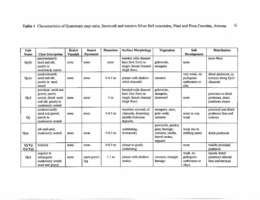
Table 1 Characteristics of Quaternary map units, Sawtooth and western Silver Bell mountains, Pinal and Pima Counties, Arizona. ,..... 0\
Unit Desert Desert Dissection Surface Morphology Vegetation Soil Distribution Name Clast description Varnish Pavement Development
predominantly braided with channel basin floor Qy2r sand and silt, none none none bars (low flow) to paloverde, none
poorly to single thread channel mesquite moderately sorted (high flow) predominantly very weak, no distal piedmont, as
Qylr sand and silt; none none 0-0.5 m planar with shallow creosote pedogenic terraces along Qy2r poorly to mod. relict channels carbonates or channels sorted clay proximal: sand and braided with channel paloverde, gravel, poorly bars (low flow) to mesquite, proximal to distal
Qy2 sorted; distal: sand none none Om single thread channel ironwood none piedmont, drain and silt, poorly to (high flow) piedmont slopes moderately sorted predominantly dendritic network of mesquite, cacti, proximal and distal sand and gravel, none none 0-0.5 m channels, dissecting palo verde, none to very piedmont fans and
Qy poorly to middle Holocene creosote weak terraces moderately sorted deposits
paloverde, prickly silt and sand, undulating, pear, bursage, weak due to
Qye moderately sorted none none 0-0.5 m hummocky creosote, cholla, shifting sands distal piedmont barrel cactus, saguaro
QyYg bedrock none none 0-0.5 m planar to gently none mainly proximal Qy(Yg) undulating piedmont
angular to weak, no mainly distal Qyl subangular none open gravel <1m planar with shallow creosote, triangle pedogenic piedmont alluvial
moderately sorted lag swales bursage carbonates or fans and terraces sand and gravel clays
!
I
Table 1 (Continued) Characteristics of Quaternary map units, Sawtooth and western Silver Bell mountains, Pinal and Pima Counties, Arizona.
Unit Clast Description Desert Desert Dissection Name Varnish Pavement
subangular to subrounded sand
Qly and gravel, poorly none none <O.5m to moderately sorted
subangularto very -1m QI subrounded, poorly weak to loose open
sorted gravels and moderate framework cobbles
QIYg subangular to weak to QI(Yg) subrounded gravels moderate none -1m
and cobbles variable;
subangular to loose open < 1 m to 1-Qlm subrounded poorly weak to framework 2m
sorted gravels and strong to cobbles moderately
packed
subangular to subrounded moderately
Qm moderately sorted moderate to well 1-2 m gravel and cobbles to strong packed
Surface Morphology Vegetation
creosote, triangle planar; gently leaf bursage, undulating in places cholla; mesquite with exposed and palo verde Pleistocene soil (along washes)
relatively planar cholla, creosote, terraces; fans have bursage, saguaro, roIling topography paleoverde (in
drainages)
roIling topography cholla, creosote, bursage, saguaro
creosote, saguaro, broadly rounded various cacti
planar surfaces or creosote; saguaro rounded ridges and paleoverde
(in drainages)
Soil Development
Holocene soils are weak, more induration and carbonate development in Pleistocene soil thin discontinuous carbonate coatings on clasts; slightly reddened soil in subsurface
none
thin discontinuous carbonate coatings on surface gravels and cobbles; reddened soil visible in places reddened subsurface soil; massive carbonate horizons with laminar caps in places with shallow bedrock
Distribution
distal piedmont alluvial fans and terraces
proximal to distal piedmont alluvial fans and terraces
proximal piedmont
proximal to medial piedmont alluvial fans and terraces
mainly proximal piedmont alluvial fans and terraces
-_._.-
...... --l
-----

........ 00
Table 1 (Continued) Characteristics of Quaternary map units, Sawtooth and western Silver Bell mountains, Pinal and Pima Counties, Arizona.
Unit Clast Description Desert Desert Dissection Surface Morphology Vegetation Soil Distribution Name Varnish Pavement Development
thin, continuous subrounded gravel, creosote, triangle carbonate cobbles, and loose to >2m planar to rounded on leafbursage, coatings on proximal piedmont
Qmo boulders, with moderate moderately surface edges paleoverde, clasts, massive alluvial fans and angular carbonate to strong packed variety of cacti carbonate terraces fragments development;
argillic horizon not observed
subrounded poorly massive sorted gravel, creosote, cholla, carbonate proximal piedmont
Qo cobbles, and strong moderately >5m planar with rounded ocotillo (check horizons, alluvial fans and boulders; abundant packed edges these with photos) continuous terraces angular carbonate coatings on fragments clasts (inferred
from surface material); no argillic horizon observed
subrounded, moderately sorted proximal to medial
Qod gravel with strong well >5m rounded ridges creosote, not observed; piedmont eroded sporadic cobbles packed fine paloverde highly eroded alluvial fan and boulders; grained remnants angular carbonate pavement fragments

Table 2 X-Ray fluorescence major element analyses of representative volcanic rocks in the Sawtooth Mountains. UTM locations of the samples are included at the end of Table 3.
Sample Unit Si02 Ti02 AI203 Fe203- MnO MgO CaO K20 Na20 P205 LOI Total Ba S wt. % wt. % wt. % wt. % wt. % wt. % wt. % wt.% wt. % wt. % wt. % wt. % ppm ppm
F9-32-CM1 Tdw 66.52 0.43 15.09 3.32 0.06 1.32 2.92 2.86 4.53 F9-32-CM2 Tdw 67.00 0.43 15.17 3.35 0.06 1.32 2.95 2.91 4.56 F9-46 Tti 66.30 0.53 15.44 3.88 0.06 1.44 3.16 4.15 3.85 F9-48 Tat 58.94 0.96 16.60 7.02 0.13 2.98 5.43 3.45 4.13 F9-51 Ttx 62.70 0.49 16.55 3.81 0.06 2.03 4.09 4.61 3.47 F9-52 Ttb 62.33 0.55 17.54 4.40 0.05 0.73 3.74 4.26 4.36 F9-58 Tdw 65.86 0.45 15.37 3.54 0.06 1.31 2.99 3.74 4.01 F9-59 Tdw 65.99 0.49 15.68 3.73 0.07 1.40 3.56 3.65 3.86 F9-62 Tbl 53.68 1.14 16.22 7.40 0.10 4.82 6.91 2.89 3.72 F9-66 Ttax 59.63 0.85 15.60 5.35 0.08 2.89 5.18 4.50 3.62 F9-67 Tbl 53.67 1.18 15.76 7.53 0.12 6.68 7.98 2.60 3.49 F9-114 Tat 59.96 0.87 16.32 6.27 0.11 2.66 4.92 3.45 3.81 F9-115 Tat 57.58 0.91 16.28 6.64 0.12 2.40 5.11 3.61 4.01 F9-117 Tti 66.54 0.50 15.42 3.73 0.07 0.99 3.25 4.25 3.64 F9-118 Tbu 54.60 1.30 15.99 7.96 0.09 3.94 6.56 2.70 3.70 F9-121 Tx 64.59 0.61 16.16 3.61 0.07 0.92 3.03 4.88 4.10 F9-122 Tq 55.90 0.75 15.80 5.75 0.09 4.77 5.76 2.92 3.73 F9-123 Tba 52.80 0.94 15.94 7.19 0.10 6.02 6.94 2.37 3.75 F9-124 Tb 53.63 1.03 17.25 7.06 0.07 3.73 6.72 2.82 4.08 F9-125 Tti 59.85 0.98 15.92 5.33 0.06 2.71 4.27 3.99 4.07 WG-73-CM Ttax 59.42 0.87 15.46 5.48 0.09 3.59 5.03 4.53 3.62 WG-73-CM Ttax 59.19 0.87 15.50 5.46 0.09 3.58 4.99 4.44 3.60 WG-73-CM Ttax 59.25 0.87 15.45 5.49 0.09 3.60 5.04 4.51 3.62 WG-77 Tbl 54.93 1.14 16.00 7.28 0.12 5.65 6.68 3.17 3.57 WG-161 Tr 72.69 0.18 12.57 1.14 0.05 0.25 2.03 5.86 2.61
Major elements are in weight percent and Ba and S are in parts per million. LOI is loss on ignition. Fe203-T is total iron expressed as Fe203. Samples with -CM1, -CM2, and -CM3 are replicates.
---------- ---
0.17 2.10 99.32 0.17 2.10 100.02 0.26 1.12 100.19 0.60 0.14 100.38 0.29 2.00 100.10 0.35 1.48 99.79 0.25 2.25 99.83 0.20 1.31 99.93 0.50 2.53 99.91 0.49 1.63 99.81 0.52 0.49 100.03 0.49 1.12 99.98 0.59 1.94 99.19 0.24 1.31 99.94 0.51 2.45 99.80 0.28 1.29 99.54 0.36 3.71 99.54 0.41 3.19 99.65 0.53 2.52 99.43 0.49 1.61 99.28 0.50 0.99 99.58 0.50 0.99 99.21 0.51 0.99 99.41 0.62 0.05 99.20 0.05 2.28 99.70
---- --
1220 1200 1220 1170 1380 1780 1210 1180 1230 1560 1250 1210 1390 1190
932 2350 1430 1180 1290 1220 1550 1530 1540 1350 1110
--
49 53 18
3 26
620 191
91 14
341 40 26
123 101
13 1270 526
90 42 341 78 69 88 31
100
........ \0

10 o
Table 3 X-Ray fluorescence trace element analyses of representative volcanic rocks in the Sawtooth Mountains. UTM locations of the samples are included at the end of this table.
Sample Unit Sr Rb Th Pb Ga Zn Cu Ni Fe203- MnO Cr Ti02 Sa V ppm ppm ppm ppm ppm ppm ppm ppm wt.% wt. % ppm wt.% ppm ppm
F9-32-CM1 Tdw 473 182 15 34 18 57 33 16 3.15 0.06 28 0.43 1254 45 F9-32-CM2 Tdw 471 183 15 33 18 57 34 16 3.15 0.05 33 0.44 1262 46 F9-46 Tti 491 149 14 19 19 62 31 16 3.74 0.06 24 0.52 1212 58 F9-48 Tat 602 93 17 16 20 96 42 33 6.72 0.13 52 0.94 1228 104 F9-52 Ttb 1077 106 11 20 20 55 37 21 3.55 0.06 24 0.53 1522 63 F9-51 Ttx 1133 108 10 21 21 62 52 5 4.18 0.05 6 0.53 1917 48 F9-58 Tdw 516 157 14 18 18 59 35 14 3.30 0.06 25 0.45 1233 49 F9-59 Tdw 555 116 13 19 19 58 33 12 3.38 0.06 19 0.46 1206 52 F9-62 Tbl 838 72 7 14 19 74 44 126 7.45 0.10 197 1.07 1377 140 F9-66 Ttax 869 149 28 24 21 62 57 46 4.92 0.07 81 0.87 1763 98 F9-67 Tbl 917 55 6 35 18 80 66 133 7.51 0.12 271 1.20 1340 156 F9-114 Tat 541 122 18 23 21 96 42 28 6.17 0.11 45 0.88 1242 101 F9-115 Tat 634 110 16 14 20 91 39 31 6.47 0.13 48 0.86 1560 111 F9-117 Tti 511 113 15 23 18 59 36 14 3.56 0.06 24 0.50 1213 52 F9-118 Tbu 718 97 7 11 20 91 34 105 8.13 0.09 153 1.30 986 133 F9-121 Tx 599 127 15 19 17 49 15 7 3.33 0.06 6 0.59 2525 55 F9-122 Tq 965 79 6 14 20 71 42 157 5.68 0.09 205 0.69 1629 100 F9-123 Tba 1002 52 5 11 21 81 50 218 7.28 0.10 303 0.95 1348 151 F9-124-CM1 Tb 1063 71 12 15 22 88 49 74 7.04 0.06 82 1.04 1439 143 F9-124-CM2 Tb 1065 71 12 15 21 85 49 74 7.06 0.06 79 1.05 1461 143 F9-124-CM3 Tb 1064 71 11 15 22 85 48 72 7.06 0.06 80 1.05 1465 142 F9-125 Tti 698 130 13 17 19 73 18 38 5.21 0.05 42 0.96 1284 74 WG-73 Ttax 919 137 26 26 20 70 79 50 5.21 0.08 103 0.94 1796 111 WG-77 Tbl 814 80 16 16 20 81 52 113 7.20 0.11 236 1.16 1465 133 WG-161 Tr 404 120 16 24 14 27 7 3 1.14 0.04 ND 0.17 1142 13
All values are in parts per million, except MnO, Ti02, and Fe203-T, which are in weight percent. Fe203-T is total iron expressed as Fe203-T. ND is below the lower limit of determination.
--

Table 3 (Continued) X-Ray fluorescence trace element analyses of representative volcanic rocks in the Sawtooth Mountains. UTM locations of the samples are included at the end of this table.
Sample As U Y Zr Nb Mo UTM north UTM east ppm ppm ppm ppm ppm ppm zone 12 zone 12
F9-32-CM1 4 3 19 249 9 2 3609675 432670 F9-32-CM2 4 3 18 251 8 2 3609675 432670 F9-46 4 3 22 319 10 NO 3608315 431610 F9-48 2 3 35 513 17 2 3608075 430900 F9-52 6 3 15 194 6 NO 3611560 430755 F9-51 11 3 16 330 6 1 3611285 431110 F9-58 4 2 19 284 9 2 3605025 430500 F9-59 3 2 17 236 8 1 3604470 429965 F9-62 2 2 22 257 8 NO 3605235 430590 F9-66 10 6 26 376 14 2 3604170 429400 F9-67 4 2 24 263 9 NO 3603370 428600 F9-114 2 3 35 484 15 2 3607470 429550 F9-115 3 3 36 495 16 2 3607710 429980 F9-117 2 2 21 311 10 NO 3607025 430190 F9-118 4 1 30 316 14 1 3610220 428275 F9-121 4 3 31 362 13 2 3609265 425965 F9-122 6 2 18 214 4 NO 3607900 431740 F9-123 13 NO 20 222 5 NO 3608000 431790 F9-124-CM1 12 1 23 294 8 NO 3607825 431675 F9-124-CM2 12 2 24 294 8 NO 3607825 431675 F9-124-CM3 12 2 24 295 8 NO 3607825 431675 F9-125 2 2 24 333 14 NO 3609510 434570 WG-73 7 7 22 401 15 2 3603485 429550 WG-77 4 2 27 365 13 NO 3603360 426735 WG-161 4 3 14 182 13 NO 3609925 428635
tv .....
s Wildcat Peak Indian Head
Tx (c«aI .. d .... ofTdw.11 ... dlbl)
-~-=~-------~TX~ jTq lbS~ ------/~ "<:: -- ---- Tb""'" ---- -------~--------____ h_
---------__ 1-------- 1 1
Tti
1
Tdw
1
w Tat Tx Tc
-~ -=-----'~:= ~ .".--, ~ ----<: ~~-__ T 111 ------ ~ c ------ llx --------
1---7 '-'-,<:::: Ttl _____ _
---- -----~-- -~-------ni- -------- ----~~---ri --------- ::-:---"'Mi- _ ---'1--
llx 1
11b
1
111 Tbu
Figure 1 Stratigraphic correlation diagram for the volcanic rocks of the Sawtooth Mountains, showing all known relationships along two diagrammatic transects of the range.
tv tv
N
Q
Figure 2 Probable mammalian trackway developed in volcaniclastic pebbly sandstone of map unit Ttx in the northern Sawtooth Mountains. Hammer handle is approximately 38 cm long.
14, • Samaniego Hills ... Sawtooth Mts
~ f 2 analyses 12 * average Of 3 analyses ** average 0
~10 F9-58 F9-46
.30-67 ... WG-161 E-2N
F9-117
~ o 8
N ~
+ 6 0 N
ro
°3 \ 'rl:l-Qt I
°2 4--1 Z
°1 I pcl B 2J
37 41 45 49 53 57 61 65 69 73 77 Si02 wt %
Figure 3 Total alkali versus silica diagram ofLe Bas and others (1986) showing analyses from the Sawtooth Mountains (this report), and analyses from the Samaniego Hills (Eastwood, 1970). Also shown is one analysis (E-2N) from an outlier ofthe trachyte oflndian Head from Banks and others (1978). Field name abbreviations are Pc: picrobasalt, B: basalt, °1: basaltic andesite, 02: Andesite, 0 3: Dacite, R: rhyolite, SI: trachybasalt, S2: basaltic trachyandesite, S3: trachyandesite, T: trachyte, VI: tephrite basalt, V 2 : phonotephrite, V3: tephriphonolite, Ph: phonolite.
~

sw ~·0 W I Silver Bell Mts Samaniego Hills Sawtooth Mts Picacho Mts
Ragged Top fault zone Ancestral Picacho detachment
Iliill~~liiii~iiil!l!i!1 Ragged Top rhyolite .. conglomerate, exotic slide blocks
.. intermediate lavas .. Silver Bell volcanics
~ mafic lavas IIlill crystalline basem ent
tv VI
NE
Figure 4 Hypothetical early Miocene structural cross-section ofthe composite Sawtooth Mountains - Samaniego Hills - Picacho Peak: volcanic field and its relationship to two major faults. The northeastern basin-bounding normal fault probably evolved into the Picacho Mountains detachment which probably died at about 20 Ma. The Ragged Top fault to the south is a major high-angle, dextral strike-slip, south-side-down structure that lies just to the south of the map area.

.~ 110 .: ~ 100 . 9
"0
'" 90 0:: ~ 80
21.5 22.0
-e- ..,:... F9-121 Single Crystal Sanidine -.!l ,
.. ~ . • •
" ~ .. Weighted Mean Age = 22.64±O.05 Ma
22.5 23.0
Age (Ma) 23.5 24.0
Figure 5 Age probability distribution diagram for sample F9-121.
0.1
100
10
24.5
Table 4 Analytical methods for the New Mexico Geochronological Research Laboratory Sample preparation and irradiation: Mineral phases .concentratedby dissolving'glass and matrix from the crushed rock in 15% HF. K-feldspar separated with
standard heavy liquid, Franz Magnetic and hand-picking techniques.
K-feldspars were loaded into a machined AI disc and irradiated for 7 hours in D-3 position, Nuclear Science Center, College Station, TX.
Neutron flux monitor Fish Canyon Tuff sanidine (FC-1). Assigned age = 27.84 Ma (Deino and Potts, 1990)
relative to Mmhb-1 at 520.4 Ma (Samson and Alexander, 1987).
Instrumentation:
Mass Analyzer Products 215-50 mass spectrometer on line with automated all-metal extraction system.
Single crystals were fused by a 10 watt Synrad C02 laser.
Reactive gases removed during a 2 minute reaction with 2 SAES GP-50 getters, 1 operated at -450'C and
1 at 20·C. Gas also exposed to a W filament operated at -2000'C and a cold finger operated at -140·C.
Analytical parameters:
Electron multiplier sensitivity averaged 1.68 x 10⁻¹⁶ moles/pA.
Total system blank and background averaged 333, 10.0, 0.9, 1.8, 1.7 x 10⁻¹⁸ moles J-factors determined to a precision of ± 0.1 % by C02 laser-fusion of 4 Single crystals from each of 4 radial positions around the irradiation tray
Correction factors for interfering nuclear reactions were determined using K-glass and CaF2 and are as follows:
(40Ar/39Ar)K = 0.00020±0.0003; (36Ar/37Ar)Ca = 0.00028±0.00OO11; and (39Ar/37Ar)Ca = 0.00089±0.00003.
Age calculations: Weighted mean age calculated by weighting each age analysis by the inverse of the variance.
Weighted mean error calculated using the method of (Taylor, 1982).
MSWD values calculated for n-1 degrees of freedom. If the MSWD is outside the 95% confidence window (cf. Mahon, 1996; Table 1), the error is multiplied by the square root of the MSWD.
Decay constants and isotopic abundances following Steiger and Jager (1977).
All final errors reported at ±2s, unless otherwise noted.

27
Table 5 Isotopic data for sample P9-121 10 4°Arf 9Ar - 37Arf9Ar 36Ar?9Ar-- -39ArK -- -K/Ca- -%4"Ar* Age
(x 1 0-3) (x 1 0-15 mol) (Ma)
F9-121, single crystal sanidine, J=O.0007644, NM-123, Lab#=51225 12 16.54 0.0133 0.4579 3.14 38.5 99.2 10 17.07 0.0112 2.212 4.49 45.5 96.2 06 16.57 0.0125 0.4543 2.30 40.7 99.2 11 16.59 0.0148 0.5113 2.79 34.4 99.1 07 16.83 0.0109 1.055 3.62 47.0 98.2 09 16.87 0.0146 1_130 4.51 35.0 98.0 01 16.56 0_0114 0.0548 2.88 44.8 99.9 08 16.71 0.0156 0.5553 2.26 32.8 99.0 02 16.80 0.0164 0.8371 2.31 31.2 98.5 03 16.99 0.0147 1.466 4.24 34.7 97.5 13 17.41 0.0127 2.877 4.18 40.3 95.1 05 16.91 0.0115 1.145 5.34 44.3 98.0 04 16.85 0.0140 0.7945 3.76 36.3 98.6 14 19.02 0.0119 8.025 4.88 42.8 87.5 weighted MSWO n=14 39.2 ±5.2 mean =3.8**
Notes: n= number of analyses used for weighted mean calculation
22.49 22.50 22.53 22.54 22.64 22.66 22.68 22.68 22.69 22.70 22.70 22.71 22.77 22.81 22.64
-±1cr (Ma)
0.04 0.04 0.07 0.06 0.05 0.04 0.05 0.06 0.06 0.05 0.05 0.05 0.05 0.06 0.05*
Isotopic ratios corrected for blank, radioactive decay, and mass discrimination, not corrected for interferring reactions. Individual analyses show analytical error only; weigthed mean age error includes error in J and irradiation parameters. Analyses in italics are excluded from mean age calculations. K/Ca = molar ratio calculated from reactor produced 39 ArK and 37 ArCa.
* 2cr error ** MSWO outside of 95% confidence interval