Embed Size (px)
Citation preview
?
?
?
��
�
��
�
� �
���
�
���
�
�
��
�
�
��
� �� �
�
�
�
�
� �
�
40
40
50
50
30
45
30
40
43
50
30
15
70
10
10
5
20
10
5
9 5
45
55
36
72
69
8550
45
41
32
32
14
spKJgvJk
QlsQls
sp
Qls
Qls
KJgv?
Qls
sp
Qls
sp
af
sp
JgbTsvasl
TsvabslQls
Qha
Tsvasl
af
Tsvasl
Tsvdg
Qhf
Tsvabsl
Tsvdg
TsvdgTsvr
Qpf Qf
Tsvdg
KJgvKJgv
TsvdgQhf
Tsvasl
Tsvdg
KJgv
Tsvr
Tsvdg
Qha
Qhf
Qls
Qha
TsvatslTgisl
Tsvabsl
Tsvabsl
Qhty
TgislQha
Qhf
Qhf
Tsvdg
Tsvabsl
Qhty
QhtyTgisl
Qhty
Tsvasl
Qpf
Tsvdg
Qf
Qhf
Tsvrt
Tsvdg
Tsvdgp
Tsvt
Tsvdg
Tsvasl
TsvaslTsvasl
TsvaslTsvdg
Tsvdg
TsvaslTsvasl
TsvaslTsvasl
Qa
Qha
Qha
Qha
Tsvt
af
af
af
afaf
af
af
af
Tsvdg
Qls
Qls
Qls
sp
Tsvt
Tsvasl
Jb
Jb
Qls
Qls
Qls
Qls
Qls
Qls sp
sp sp
KJfs
KJfs
Qls
Qls
Qls
Qls
Qls
Qls
Qls
Qls
Qls
QlsQls
Qls
af
Qls
Qls
Qls
Qls
sp
Tsvasl
Tsvt
Qhc
sp
Qha
Qha
Qls
Qls
af
af
af
Qls
Qls
Qls
Tsvt
KJgv
Tsvdgp
Tsvdg
Tsvdgp
Qhf
Qhf
Qf
Qpf
Qhf
Qf
KJgv
Qpf
Tsvatsl
Qpf
Qha
Qhty
Qhty
Qhf
Tsvdg
Qha
Qf
Qf
Qhfy
Qhty
Tsvdg
Qf
Qht
Tsvabsl
Tsvdg
af
af
Qls
Qhty
Tsvasl
Tsvdgaf
Qhty
Qhty
alf
alf
Qhty
QhcKJgv
af
afaf
af
Qhty
Qhty
Qls
Qf
KJgv
QfTsvasl
Qls
Qht
af
afafTsvasl
QfTgisl
Qls
KJgv
af
KJgv
af
KJgvaf
KJgvm af
KJgv
Tsvatsl
Qha
Qhc
af
alf
af
af
alf
af
Qhc
af
ac
af
Qls
Qls
QlsQls
Tsvdg
Tsvatsl
Qls
Qls
Qls
Qhc af
afaf
Qhc
Qhty
af
af
afaf
af
Qhc
alf Qhty
Qls
af
afaf
Qls
Qls
af
af
Tsvdgp
Tsvdgp
Tsvdg
Tsvdg
Tsvdg
Tsvdg
Tsvdgp
Tsvdg
Tsvasl
Tsvdgp
KJgv
KJgv
Qls
Qha
Qf
Tsvabsl
Qhty
Tsvt
Tsvt
Tsvasl
Tsvabsl
Qha
Qha
Qhc
Qhty
Tsvabsl
Th
Th
ThKJfs
Th
Tsvpf
Qls
Qls
Qhf
Qhty
Tsvasl
?
Qhty
Qf
?
?
QhtyQhfy
?
Qpf
Qoa
UTM GRID AND 1968 MAGNETIC NORTHDECLINATION AT CENTER OF SHEET
0°26'8 MILS
18°320 MILS
GNMN
0
0
0
1
1
1.5
.5 2
2
2Thousand Feet
Kilometers
Miles
Contour Interval 20 FeetDotted Lines Represent 5 Foot Contours
Scale 1:24,000
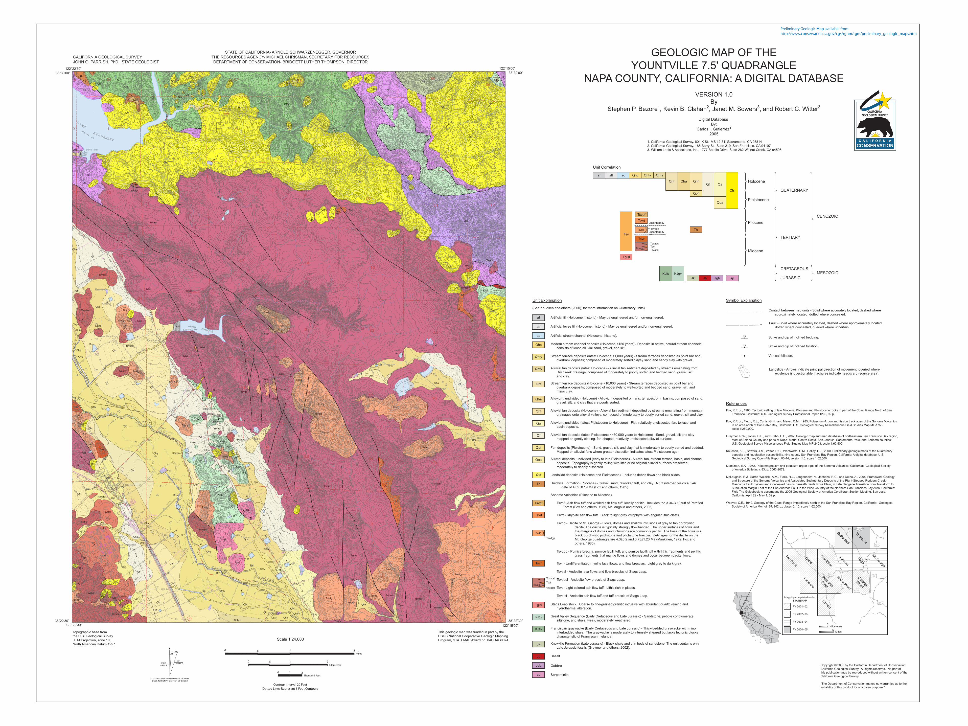
Fox, K.F. Jr., 1983, Tectonic setting of late Miocene, Pliocene and Pleistocene rocks in part of the Coast Range North of San
Francisco, California: U.S. Geological Survey Professional Paper 1239, 92 p.
Fox, K.F. Jr., Fleck, R.J., Curtis, G.H., and Meyer, C.M., 1985, Potassium-Argon and fission track ages of the Sonoma Volcanics
in an area north of San Pablo Bay, California: U.S. Geological Survey MIscellaneous Field Studies Map MF-1753,
scale 1:250,000.
Graymer, R.W., Jones, D.L., and Brabb, E.E., 2002, Geologic map and map database of northeastern San Francisco Bay region,
Most of Solano County and parts of Napa, Marin, Contra Costa, San Joaquin, Sacramento, Yolo, and Sonoma counties:
U.S. Geological Survey Miscellaneous Field Studies Map MF-2403, scale 1:62,500.
Knudsen, K.L., Sowers, J.M., Witter, R.C., Wentworth, C.M., Helley, E.J., 2000, Preliminary geologic maps of the Quaternary
deposits and liquefaction susceptibility, nine-county San Francisco Bay Region, California: A digital database: U.S.
Geological Survey Open-File Report 00-44, version 1.0, scale 1:52,500.
Mankinen, E.A., 1972, Paleomagnetism and potasium-argon ages of the Sonoma Volcanics, California: Geological Society
of America Bulletin, v. 83, p. 2063-2072.
McLaughlin, R.J., Sarna-Wojcicki, A.M., Fleck, R.J., Langenheim, V., Jachens, R.C., and Deino, A., 2005, Framework Geology
and Structure of the Sonoma Volcanics and Associated Sedimentary Deposits of the Right-Stepped Rodgers Creek-
Maacama Fault System and Concealed Basins Beneath Santa Rosa Plain, in Late Neogene Transition from Transform to
Subduction Margin East of the San Andreas Fault in the Wine Country of the Northern San Francisco Bay Area, California:
Field Trip Guidebook to accompany the 2005 Geological Society of America Cordilleran Section Meeting, San Jose,
California, April 29 - May 1, 52 p.
Weaver, C.E., 1949, Geology of the Coast Range immediately north of the San Francisco Bay Region, California: Geological
Society of America Memoir 35, 242 p., plates 6, 10, scale 1:62,500.
References
12 121
37
780
128
12116
5Kilometers
5Miles
Mapping completed under
STATEMAP
FY 2001- 02
FY 2002- 03
FY 2003- 04
FY 2004- 05
NapaSonom
a
Novato
Mt. G
eorge
Napa
Petalum
a
Petalum
aRiver
Cuttings
Wharf
Glen E
llen
Cotati
Two R
ock
Sears P
oint
Yountville
Rutherford
GEOLOGIC MAP OF THE
YOUNTVILLE 7.5' QUADRANGLE
NAPA COUNTY, CALIFORNIA: A DIGITAL DATABASE
VERSION 1.0
By
Stephen P. Bezore1, Kevin B. Clahan2, Janet M. Sowers3, and Robert C. Witter3
Digital Database
By:
Carlos I. Gutierrez1
2005
Copyright © 2005 by the California Department of Conservation
California Geological Survey. All rights reserved. No part of
this publication may be reproduced without written consent of the
California Geological Survey.
"The Department of Conservation makes no warranties as to the
suitability of this product for any given purpose."
This geologic map was funded in part by the
USGS National Cooperative Geologic Mapping
Program, STATEMAP Award no. 04HQAG0074
Topographic base from
the U.S. Geological Survey
UTM Projection, zone 10,
North American Datum 1927
STATE OF CALIFORNIA- ARNOLD SCHWARZENEGGER, GOVERNOR
THE RESOURCES AGENCY- MICHAEL CHRISMAN, SECRETARY FOR RESOURCES
DEPARTMENT OF CONSERVATION- BRIDGETT LUTHER THOMPSON, DIRECTOR
CALIFORNIA GEOLOGICAL SURVEY
JOHN G. PARRISH, PhD., STATE GEOLOGIST
38°22'30"
122°22'30" 122°15'00"
38°22'30"
122°15'00"
38°30'00"
122°22'30"
38°30'00"
1. California Geological Survey, 801 K St. MS 12-31, Sacramento, CA 95814
2. California Geological Survey, 185 Berry St., Suite 210, San Francisco, CA 94107
3. William Lettis & Associates, Inc., 1777 Botello Drive, Suite 262 Walnut Creek, CA 94596
Preliminary Geologic Map available from:http://www.conservation.ca.gov/cgs/rghm/rgm/preliminary_geologic_maps.htm
Strike and dip of inclined bedding.25
Landslide - Arrows indicate principal direction of movement, queried where
existence is questionable; hachures indicate headscarp (source area).
Contact between map units - Solid where accurately located, dashed where
approximately located, dotted where concealed.
25 Strike and dip of inclined foliation.
Vertical foliation.
Fault - Solid where accurately located, dashed where approximately located,
dotted where concealed, queried where uncertain.?
Symbol Explanation
QUATERNARY
Pliocene
Holocene
Pleistocene
Miocene
TERTIARY
CENOZOIC
Unit Correlation
MESOZOICCRETACEOUS
JURASSIC
af alf ac Qhc Qhty Qhfy
Qht Qha QhfQf Qa
Qoa
Qls
sp
KJfs KJgv
Th
unconformity
unconformityTsv
Tsvrt
Tsvr
Tsvasl
Tsvdg Tsvdgp
TsvabslTsvt
Tsvatsl
Jb JgbJk
Tgisl
Tsvpf
Qpf
Landslide deposits (Holocene and Pleistocene) - Includes debris flows and block slides.
Serpentinite
Alluvium, undivided (latest Pleistocene to Holocene) - Flat, relatively undissected fan, terrace, and
basin deposits.
Fan deposits (Pleistocene) - Sand, gravel, silt, and clay that is moderately to poorly sorted and bedded.
Mapped on alluvial fans where greater dissection indicates latest Pleistocene age.
Alluvial deposits, undivided (early to late Pleistocene) - Alluvial fan, stream terrace, basin, and channel
deposits. Topography is gently rolling with little or no original alluvial surfaces preserved;
moderately to deeply dissected.
Alluvium, undivided (Holocene) - Alluvium deposited on fans, terraces, or in basins; composed of sand,
gravel, silt, and clay that are poorly sorted.
Stream terrace deposits (latest Holocene <1,000 years) - Stream terraces deposited as point bar and
overbank deposits; composed of moderately sorted clayey sand and sandy clay with gravel.
Alluvial fan deposits (latest Holocene) - Alluvial fan sediment deposited by streams emanating from
Dry Creek drainage, composed of moderately to poorly sorted and bedded sand, gravel, silt,
and clay.
Modern stream channel deposits (Holocene <150 years) - Deposits in active, natural stream channels;
consists of loose alluvial sand, gravel, and silt.
Artificial stream channel (Holocene, historic).
Artificial fill (Holocene, historic) - May be engineered and/or non-engineered.
Artificial levee fill (Holocene, historic) - May be engineered and/or non-engineered.
Alluvial fan deposits (Holocene) - Alluvial fan sediment deposited by streams emanating from mountain
drainages onto alluvial valleys; composed of moderately to poorly sorted sand, gravel, silt and clay.
(See Knudsen and others (2000), for more information on Quaternary units).
Alluvial fan deposits (latest Pleistocene <~30,000 years to Holocene) - Sand, gravel, silt and clay
mapped on gently sloping, fan-shaped, relatively undissected alluvial surfaces.
Stream terrace deposits (Holocene <10,000 years) - Stream terraces deposited as point bar and
overbank deposits; composed of moderately to well-sorted and bedded sand, gravel, silt, and
minor clay.
Unit Explanation
Qhfy
alf
af
Qhf
Qls
Qa
Qpf
Qoa
Qha
Qhty
Qhc
ac
Qf
Qht
Tgisl
Th
KJfs
Jb
Jgb
Jk
sp
KJgv
Tsvrt
Tsvpf
Tsvr
Tsvdg
Tsvdgp
Tsvasl
Tsvabsl
Tsvatsl
Tsvt
Gabbro
Basalt
Great Valley Sequence (Early Cretaceous and Late Jurassic) - Sandstone, pebble conglomerate,
siltstone, and shale, weak, moderately weathered.
Stags Leap stock. Coarse to fine-grained granitic intrusive with abundant quartz veining and
hydrothermal alteration.
Franciscan graywacke (Early Cretaceous and Late Jurassic) - Thick-bedded graywacke with minor
interbedded shale. The graywacke is moderately to intensely sheared but lacks tectonic blocks
characteristic of Franciscan melange.
Knoxville Formation (Late Jurassic) - Black shale and thin beds of sandstone. The unit contains only
Late Jurassic fossils (Graymer and others, 2002).
Huichica Formation (Pliocene) - Gravel, sand, reworked tuff, and clay. A tuff interbed yields a K-Ar
date of 4.09±0.19 Ma (Fox and others, 1985).
Sonoma Volcanics (Pliocene to Miocene)
Tsvpf - Ash flow tuff and welded ash flow tuff, locally perlitic. Includes the 3.34-3.19 tuff of Petrified
Forest (Fox and others, 1985, McLaughlin and others, 2005).
Tsvrt - Rhyolite ash flow tuff. Black to light grey vitrophyre with angular lithic clasts.
Tsvdg - Dacite of Mt. George - Flows, domes and shallow intrusions of gray to tan porphyritic
dacite. The dacite is typically strongly flow banded. The upper surfaces of flows and
the margins of domes and intrusions are commonly perlitic. The base of the flows is a
black porphyritic pitchstone and pitchstone breccia. K-Ar ages for the dacite on the
Mt. George quadrangle are 4.3±0.2 and 3.73±1.23 Ma (Mankinen, 1972; Fox and
others, 1985).
Tsvdgp - Pumice breccia, pumice lapilli tuff, and pumice lapilli tuff with lithic fragments and perlitic
glass fragments that mantle flows and domes and occur between dacite flows.
Tsvr - Undifferentiated rhyolite lava flows, and flow breccias. Light grey to dark grey.
Tsvasl - Andesite lava flows and flow breccias of Stags Leap.
Tsvabsl - Andesite flow breccia of Stags Leap.
Tsvt - Light colored ash flow tuff. Lithic rich in places .
Tsvatsl - Andesite ash flow tuff and tuff breccia of Stags Leap.