Embed Size (px)
Citation preview

1
The Geologic Resources Inventory (GRI) provides each of 270 identified natural area National Park System units with a geologic scoping meeting and summary (this document), a digital geologic map, and a Geologic Resources Inventory report. The purpose of scoping is to identify geologic mapping coverage and needs, distinctive geologic processes and features, resource management issues, and monitoring and research needs. Geologic scoping meetings generate an evaluation of the adequacy of existing geologic maps for resource management, provide an opportunity to discuss park-specific geologic management issues, and if possible include a site visit with local experts. The National Park Service held a GRI scoping meeting for Herbert Hoover National Historic Site on June 17, 2011, at the park’s Visitor Center. Bruce Heise (NPS Geologic Resources Division) facilitated the meeting and led the discussion regarding geologic issues, features, and processes at the park. GIS specialist Andrea Croskrey (NPS Geologic Resources Division) led the discussion of map coverage. Following park historian Cary Wiesner’s account of Herbert Hoover’s early geological life, Ray Anderson (Iowa Geological and Water Survey) provided an overview of the bedrock geology of the region, and Stephanie Tassier-Surine presented a summary of the Quaternary geology. In the afternoon, Pete Swisher (Superintendent, Herbert Hoover National Historic Site) and Cary Wiesner (Historian, Herbert Hoover National Historic Site) led a fieldtrip through the historic site. Following the meeting, Deborah Quade, Ray Anderson, and Stephanie Tassier-Surine of the Iowa Geological and Water Survey led a fieldtrip to the Devonian Fossil Gorge in the Coralville Dam Emergency Spillway. Participants at the meeting included NPS staff from the park and Geologic Resources Division, and cooperators from the Iowa Geological and Water Survey and Colorado State University. Contact information for the participants is listed in the Scoping Meeting Participant table at the end of this summary (table 3). This scoping summary highlights the GRI scoping meeting for Herbert Hoover National Historic Site including the geologic setting, the plan for providing a digital geologic map, a discussion of geologic resource management issues, a description of significant geologic features and processes, and a record of meeting participants.
Herbert Hoover’s Connection to Geology Fascinated at an early age with agates and stones he picked up along the railroad tracks in West Branch, Iowa, Herbert Hoover continued his interest in rocks and fossils when, orphaned at age 11, he went to live with his uncle in Oregon. When he boarded the train in West Branch, Iowa in 1885, Hoover had two dimes sewn into his clothes and an ambition to earn his own way in the world “without the help of anybody, anywhere” (qtd. in Smith et al. 8). Working in his uncle’s Oregon Land Company, Hoover mastered bookkeeping and typing and caught the attention of a visiting engineer, also a Quaker, who was instrumental in enrolling Hoover in Stanford University’s first graduating class.
Geologic Resources Inventory Scoping Summary Herbert Hoover National Historic Site, Iowa
Prepared by John Graham August 3, 2011
Geologic Resources Division National Park Service US Department of the Interior
2
At Stanford, Hoover majored in geology and earned his way through school by typing material for Professor John Caspar Branner (Smith et al. 2007). Hoover also managed the baseball and football teams, started a laundry, ran a lecture agency, became a member of the surveying squad, and as student body treasurer, eliminated a $2,000 student government debt. Branner got Hoover a summer job with the U.S. Geological Survey mapping the terrain in the Ozark Mountains, and the next summer, Hoover worked in Yosemite National Park. It was in Branner’s geology lab where Hoover met his future wife, Miss Lou Henry, a banker’s daughter from Waterloo, Iowa (Smith et al. 2007). Hoover graduated from Stanford three months before his 21st birthday and started his geology career by shoveling ore in Nevada City, California for two dollars per ten hour shift. Stretching the truth about his age, Hoover convinced the London firm of Bewick, Moreing to hire him as a geologist. They sent him to the Australian Outback where, as Smith et al. state, “Hoover won the trust of rowdy Aussies by his take charge ways and democratic habits” (p. 9). Following a vein of gold, he discovered a deposit that would become the Sons of Gwalia mine and result in $65 million for Bewick, Moreing. By 1898, Hoover was making $10,000 a year. Sent to China, Hoover became known as the “doctor of sick mines” for finding ways to make old mines profitable. In 1900, the Hoovers were caught up in the Boxer rebellion. Trapped with other westerners, they built barricades of rice and grain sacks. Once, while riding her bicycle, Lou’s tire was punctured by a bullet. One day, an artillery shell crashed into the front hall of their house, destroying part of the staircase. A few days later, Lou read her obituary in a California newspaper. Two weeks after the siege began, the American Marines came to the rescue. Geology propelled Herbert Hoover around the globe several times over. He was a familiar figure on four continents. He lived in London, caught malaria in Asia, and backed out of a mine in Burma after seeing fresh tiger tracks (Smith et al. 2007). For three years, Hoover and his wife travelled by ship to almost forty nations. While at sea, they translated De Re Metallica, the 16th century Latin scholar Georgias Agricola’s classic work. In 1908, Hoover quit Bewick, Moreing to start his own international consulting firm. He employed 175,000 workers from Siberia to Peru. He joined Stanford’s Board of Trustees. By 1914, the 40-year old Hoover was worth $4 million. Hoover’s geology career ended when the Austrian Archduke Franz Ferdinand was assassinated in August, 1914, igniting World War I. As Hoover remarked, “I did not realize it at the moment, but on August 3, 1914, my engineering career was over forever. I was on the slippery road of public life” (qtd. in Smith et al. 11). At the beginning of WWI, 120,000 Americans were trapped in Europe, many of them in Belgium. Hoover organized and administered the Commission for Relief in Belgium, which is credited for saving ten million people from starvation. By 1918, Hoover had become an international hero for his humanitarian work, and as he later realized, his prospecting days were over.
Park and Geologic Setting Although currently located approximately 1,500 km (950 mi) from the nearest ocean, Herbert Hoover National Historic Site was once inundated by vast, shallow seas that covered most of what is now North America (fig. 1). From approximately 530 to 300 million years ago, throughout most
3
of the Paleozoic era, sediments were deposited in marine and shoreline environments that advanced and retreated across Iowa as relative sea level rose and fell. These sediments eventually lithified into the sandstone, limestone, and dolomite that now form the bedrock beneath the state. At the time, Iowa was located south of the Equator, and the invertebrate marine fossils such as trilobites, brachiopods, corals, and crinoids attest to the warm, subtropical environment that resembled today’s Caribbean climate. When sea level fell, the land was exposed to erosion. For example, beneath Herbert Hoover National Historic Site, the bedrock surface consists of Silurian-age rocks that formed approximately 430 to 420 million years ago and Devonian-age rocks deposited approximately 397 to 390 million years ago. Although younger Paleozoic rocks (and even Mesozoic rocks) can be found in other parts of Iowa, they have been eroded from the Herbert Hoover region as a result of millions of years of subaerial exposure. No bedrock is exposed in Herbert Hoover National Historic Site. The surface of the oldest bedrock unit lies about 69 m (225 ft) beneath the historic site. This unit is the Scotch Grove Formation, which was deposited approximately 430 to 426 million years ago during the Early Silurian. A variety of carbonate rocks are included in the Scotch Grove Formation including flat-lying, sparsely fossiliferous, cherty dolomites and dolomitized carbonate buildups. These carbonate mounds are reef-like structures containing a core of carbonate mud and an assortment of skeletal debris and molds from crinoids, corals, and stromatoporoids (an extinct class of marine sponges) (Witzke 1981). The overlying Gower Formation, also Silurian, consists of both flat-lying, very thin layers (laminations) of dolomite and carbonate buildups similar to those in the Scotch Grove Formation. However, while the Scotch Grove mounds are dominated by echinoderm fossils (primarily crinoids), the mounds in the Gower Formation contain abundant brachiopod fossils. Both the laminated strata and the mounds appear to progressively bury the Scotch Grove carbonate mounds. Sedimentary structures and a dearth of fossils suggest that the laminated, flat-lying dolomite was deposited in a subtidal, hypersaline environment. The fossiliferous mounds originated in shallower water that maintained open marine circulation conducive to a rich variety of benthic organisms. The formation represents a time when relative sea level fell and an embayment was established in east-central Iowa in which denser, more saline seawater lay beneath an upper surface layer of less saline and better aerated water (Witzke 1981). Sea level continued to fall, and subaerial exposure resulted in erosion and the creation of an extensive unconformity, or gap, in the stratigraphic succession between the Gower Formation and the Middle Devonian Wapsipinicon Group. A water well drilled in West Branch in 1969 encountered the Wapsipinicon Group at a depth of 30 m (100 ft). The Wapsipinicon Group in Iowa consists of three formations: the basal Bertram Formation, the Otis Formation, and the Pinicon Ridge Formation (Witzke and Bunker 2006). The unfossiliferous, vuggy dolomite of the Bertram Formation lies above Silurian strata but is restricted to a small area in east-central Iowa that adjoins northwestern Illinois. The formation represents deposition in a restricted marine to terrestrial environment.
4
Carbonate strata in the Otis Formation contain normal marine fauna, including brachiopods, trilobites, corals, and stromatoporoids. The marine fauna indicate a marine transgression in which sea level rose and the initial incursion of Devonian seas entered eastern Iowa (Witzke et al. 1988). Following deposition of the Otis Formation, sea level fell again and an episode of erosion and carbonate dissolution formed a karst surface upon which the basal unit of the Pinicon Ridge Formation was deposited. East-central Iowa remained located in the tropics, so that evaporitic conditions resulted in thick deposits of gypsum and anhydrite. Subsurface, economic deposits of gypsum have been mined near Sperry, Iowa. In general, the Pinicon Ridge Formation represents highly restricted environments of deposition that formed when sea level fell and the shoreline retreated from the region (regression). The lack of fossils and the presence of burrows, stromatolites, and ostracods in the formation record deposition within a restricted basin of elevated salinity. Organic-rich layers indicate anaerobic environments in which organic material did not decompose. When freshly broken, the organic-rich units emit a distinctive fetid odor (Witzke 2006). The Wapsipinicon Group is the youngest bedrock unit beneath Herbert Hoover National Historic Site, but roughly 1 km (0.6 mi) southeast of the monument, the Middle-to-Upper Devonian Cedar Valley Group forms the bedrock surface at a depth of approximately 61-69 m (200-225 ft). The marine carbonates, which represent another transgressive episode, lie south of a northeast-to-southeast trending fault zone, called the Iowa City-Clinton Fault Zone, that is no longer active. Abundant marine fossils in the Cedar Valley Group are also exposed in the remarkable Devonian Fossil Gorge in the Coralville Dam Emergency Spillway (see the Field Trip section of this summary). Horizontal and vertical fractures cut the limestone strata in the spillway and provide conduits for water to flow into the subsurface. Groundwater in these fracture systems is an important water source for the region. The 30 m (100 ft) of unconsolidated sediment above the Wapsipinicon Group in the 1969 West Branch water well consists of glacial till, a general term for unsorted material deposited directly by or underneath a glacier. During the early and middle Pleistocene (about 2.6 million years ago to 500,000 years ago), glaciers flowed across Iowa and into Missouri, and upon melting, left thick deposits of glacial debris (Mickelson and Colgan 2004; Roy et al. 2004; Bettis III et al. 2010). Beneath Herbert Hoover National Historic Site, the unconformity between the glacial till and Wapsipinicon Group represents approximately 390 million years of missing stratigraphic record. Erosion from numerous glacial advances and interglacial episodes produced the irregular bedrock topography buried beneath most of Iowa’s landscape today. Herbert Hoover National Historic Site lies near the northern boundary of the Southern Iowa Drift Plain (SIDP) (fig. 2). Glaciers advanced several times over the SIDP during the interval from 2.2 million years to 500,000 years ago. At least seven glacial till units have been recognized in the region. Updated glacial terminology defines these early and middle Pleistocene deposits as “pre-Illinoian” glacial till (Mickelson and Colgan 2004; Bettis III et al. 2010). The unconsolidated units of clay, silt, sand, and gravel have been divided into two pre-Illinoian formations, the Alburnett Formation and the younger Wolf Creek Formation. Because the unsorted
5
sediments in these units are very similar, laboratory methods that identify various physical and mineralogical characteristics, rather than field properties, are used to differentiate the different tills. Each of these formations includes multiple glacial tills and paleosols (old soils) that record several glacial and interglacial episodes. The detrital remnant magnetism of Alburnett Formation tills in the region of the park display a reversed polarity, indicating that they were deposited over 790,000 years ago (the Bruhnes reversed/Matuyama normal boundary) (Bettis III et al. 2010). At the type section in Alburnett, Iowa, where the formation was first described, the Alburnett is 10 m (33 ft) thick, but the thickness can range from less than 1 m (3.3 ft) to 76 m (250 ft) in east-central Iowa (Hallberg 1980). In contrast with the Alburnett Formation, Wolf Creek Formation glacial tills have a normal polarity, indicating deposition younger than the Bruhnes/Matuyama boundary (Bettis III et al. 2010). The formation consists of glacial till as well as fluvial sediments and paleosols (Halberg et al. 1980; Halberg et al. 1984; Kemmis et al. 1992). The fine-grained sediment and abraded stones in the massive, texturally and compositionally uniform tills are known as “basal” tills, meaning they were dragged along and deposited beneath the glacier. The last continental glacier entered Iowa between 14,000 and 12,000 years ago during the Wisconsin Glaciation. At this time, an ice lobe, called the Des Moines Lobe, flowed from the Minnesota border to Des Moines, Iowa, but did not extend as far east as Herbert Hoover National Historic Site (fig. 2). However, two loess (wind-blown silt) deposits in eastern Iowa resulted from this glacial episode. The oldest unit is known as the Pisgah Formation and consists of a thin sheet of loess that has been reworked by colluvial processes (rainfall, sheetwash, downslope creep) and altered by soil-forming processes. The Pisgah Formation is slightly more dense and grayer in color than the Peoria loess. The younger, thicker loess deposit is the Peoria Formation. Accumulation of the Peoria Formation began about 23,000 years ago and continued until approximately 11,000 years before present (Bettis III et al. 2010). Rapid deposition of the Peoria Formation occurred from about 21,000 to 16,000 years ago during the coldest and driest portion of the late Wisconsin glacial period. Both loess units were deposited on the uplands of eastern Iowa and have been subjected to post-glacial and Holocene (11,000 years ago to present) erosion. Peoria Loess in the Herbert Hoover National Historic Site may locally be 6 m (20 ft) thick. Over the last approximately 10,500 years, downcutting and headward extension of drainage systems in Iowa have been the main processes modifying the landscape. Holocene alluvial and valley fill sediments make up the DeForest Formation and provide information on the paleoclimate and paleoenvironment over the last 10,500 years (Bettis III et al. 1992). Today, Hoover Creek, a tributary of the West Branch of Wapsinonoc Creek, flows through the historic site.
Geologic Mapping for Herbert Hoover National Historic Site During the scoping meeting, Andrea Croskrey (NPS Geologic Resources Division) showed some of the main features of the GRI Program’s digital geologic maps, which reproduce all aspects of paper maps, including notes, legend, and cross sections, with the added benefit of being GIS compatible. The NPS GRI Geology-GIS Geodatabase Data Model incorporates the standards of digital map creation for the GRI Program and allows for rigorous quality control. Staff members digitize maps

6
or convert digital data to the GRI digital geologic map model using ESRI ArcGIS software. Final digital geologic map products include data in geodatabase and shapefile format, layer files complete with feature symbology, FGDC-compliant metadata, a PDF that captures ancillary map data, and a map document that displays the map. Final data products are posted at the NPS Natural Resource Information Portal at http://science.nature.nps.gov/nrdata/. The data model is available at http://science.nature.nps.gov/im/inventory/geology/GeologyGISDataModel.cfm. When possible, the GRI Program provides large scale (1:24,000) digital geologic map coverage for each park’s area of interest, which is often composed of the 7.5-minute quadrangles that contain park lands (fig. 3). Maps of this scale (and larger) are useful to resource managers because they capture most geologic features of interest and are spatially accurate within 12 m (40 ft). The process of selecting maps for management begins with the identification of existing geologic maps and mapping needs in the vicinity of the park. Scoping session participants then select appropriate source maps for the digital geologic data (table 1) or develop a plan to obtain new mapping, if necessary. The predefined 7.5’ quadrangles of interest for the parks are the Iowa City East, West Branch, and West Liberty (fig. 3). These quadrangles lie in Cedar, Johnson and Muscatine counties. Herbert Hoover National Historic Site is in Cedar County. During the scoping meeting, participants determined that both surficial and bedrock geology coverage was desired for the park. The park agreed that they only needed the surficial geology for the Iowa City East and West Branch 7.5’ quadrangles. They weren’t sure why West Liberty had been listed as one of their quadrangles of interest. Since the bedrock is available for the West Liberty quadrangle, it will be provided. The 30’x 60’ quadrangle applicable to Herbert Hoover National Historic Site is the Iowa City map. The Davenport 1° x 2°degree sheet is the smallest-scale map covering the area. No mapping specific to these quadrangles exists as mapping in Iowa tends to be at the 7.5’ quadrangle or county scale. Surficial Geology To provide the surficial mapping for the park, participants decided to use the 1:24,000 map for the Iowa City East 7.5’ quadrangle (gmap 75460). The majority of the West Liberty 7.5’ quad is covered by the 1:100,000 map for Cedar County (gmap 75464), and the sliver between the Iowa City East quad and the Cedar County line would be filled with the 1:100,000 surficial map for Johnson County (gmap 75556). The GIS data for Johnson County isn’t posted on the Iowa DNR GIS Library website (http://www.igsb.uiowa.edu/webapps/nrgislibx/) because the metadata hasn’t been written, but Stephanie Tassier-Surine of the IGWS said she could provide it. Edge-matching issues may occur between the datasets due to scale differences and lumping and splitting of units, but Stephanie offered to help with some of them. Bedrock Geology Bedrock mapping for the area will be from the Bedrock Geology of Cedar County (gmap 75463) and the statewide Bedrock Geologic Map of Iowa (gmap 75555) dataset from 2010. Ray Anderson (Iowa Geological & Water Survey) suggested using the statewide dataset instead of the southeast Iowa dataset (gmap 73501) of Witzke et al. (2004) because it was more current. He also volunteered to assist with any edge-matching issues between the county and statewide data, although he thought these issues should be minor.

7
Table 1. GRI Mapping Plan for Herbert Hoover National Historic Site Covered Quadrangles
GMAP1 Citation Scale Format Assessment GRI Action
Iowa City East 7.5’
75460 Krieg, J.J., S.A. Tassier-Surine, D.J. Quade, E.A. Bettis III, J.A. Artz, and J.D. Giglierano. 2004. Surficial geologic materials of the Iowa City East 7.5` quadrangle, Johnson County, Iowa. Iowa Geological Survey, Open-File Map OFM-04-5 (scale 1:24,000).
1: 24,000 GIS and PDF
More data than on gmap 75556; map has a few edge-matching issues with the smaller scale county data.
Convert this map.
Sliver between Iowa City East 7.5’ and Cedar County
75556 Tassier-Surine, S.A., J.J. Krieg, D.J. Quade, E.A. Bettis III, J.A. Artz, and J.D. Giglierano. 2004. Surficial geologic materials of Johnson County, Iowa. Iowa Geological Survey, Open-File Map OFM-04-3 (scale 1:100,000)
1:100,000 GIS and PDF
Clip this to cover the gap between Iowa City East and Cedar County; need GIS from Tassier.
Clip and convert this map.
West Branch 7.5’
75464 Quade, D.J., S. Tassier-Surine, J.D. Giglierano, and E.A. Bettis III. 2008. Surficial geology of Cedar County, Iowa final phase: Surficial geologic map of Cedar County. Iowa Geological Survey, Open-File Map OFM-08-8 (scale 1:100,000).
1:100,000 GIS and PDF
Covers some of West Liberty quad, but park said they are ok without the West Liberty quad.
Clip and convert this map.
West Branch 7.5’
75463 Witzke, B.J., and R.R. Anderson. 2008. Bedrock geology of Cedar County, Iowa final phase: Bedrock geologic map of Cedar County, Iowa Geological Survey, Open-File Map OFM-08-7 (scale 1:100,000).
1:100,000 GIS and PDF
Talk to Ray Anderson about edge-matching with the statewide GIS.
Clip and convert this map.
Iowa City East 7.5’ and West Liberty 7.5’
75555 Witzke B.J, R.R. Anderson, and J.P. Pope. 2010. Bedrock geologic map of Iowa. Iowa Geological Survey, Open File Map OFM-2010-01, (scale 1:500,000).
1:500,000 GIS Clip and convert this map.
1GMAP numbers are unique identification codes used in the GRI database.

8
Figure 3. Area of interest for Herbert Hoover National Historic Site, Iowa. The 7.5-minute quadrangles are labeled in black; names in brown indicate counties. Green outlines indicate park boundaries.
Geologic Resource Management Issues The scoping session for Herbert Hoover National Historic Site provided the opportunity to discuss geologic resource management issues that are relevant to the park. These issues will be further explained in the final GRI report. Hoover Creek: Incision, Erosion, Flooding The most significant geologic issues at Herbert Hoover National Historic Site involve incision, erosion, and flooding of Hoover Creek, the unofficial name for the creek flowing through the park. Hoover Creek drains approximately 690 ha (1,700 ac) of agricultural, rural residential, and urban land. Agricultural practices stemming from the late 19th century and new residential and commercial development west of the park have increased surface runoff into Hoover Creek. Drain tiles installed in adjacent agricultural land to promote subsurface drainage have also contributed to increased flow into Hoover Creek and subsequent downcutting. Increased runoff has caused severe incision of the creek’s channel into the underlying pre-Illinoian glacial till (fig. 4A). Incision has steepened and undercut the stream banks, causing slumping and an increased sediment-load in the stream. Trees, whose roots once stabilized the banks, have been undercut and may eventually fall over. Incision
9
and associated bank erosion have undercut a drain tile installed in the park in 1994. The tile, which once emerged onto a slope that existed between the tile and the stream, has collapsed into the creek (fig. 4B). Known archaeological sites along the stream may also be impacted by channel incision and associated bank erosion. Hoover Creek meanders through the park and both Herbert Hoover’s Birthplace Cottage and the Herbert Hoover Presidential Library-Museum lie within its floodplain (fig. 5). Prior to settlement in the 19th century, trees lined the stream banks of the Wapsinonoc and its tributaries, and wetlands slowly drained into the creeks. Early settlers cut the trees and drained the wetlands. Fields were tiled and plowed to the edge of the creek. Until recently, common agricultural practices included plowing fields in the fall, after the crops were harvested, rather than leaving stubble in the field throughout the winter to help hold the soil in place. This practice led to increased soil erosion and surface runoff in the spring when rain fell on bare, still frozen ground. In effect, agricultural practices of the 19th and 20th centuries altered the hydrogeology of the region from a groundwater-based system to a surface water system (NPS 2011). As residential development has increased west of Hoover Highway so has flooding of Hoover Creek. Flash floods during peak flows now threaten several park structures, including the Birthplace Cottage and Presidential Library (fig. 6). From 1991 through 2003, 18 floods impacted the park, inundating park buildings or infrastructure and interrupting services to visitors (NPS 2006). Much of the park was flooded and historic structures threatened by the 1993 flood. In 2008, the maintenance building was partially flooded. Further residential development west of West Branch may result in increased flooding. As a preventive measure, the Birthplace Cottage has been raised to avoid the impacts from flooding. The U.S. Geological Survey has installed a real-time stream gage within the park boundaries in order to monitor stream discharge, temperature, and rainfall for Hoover Creek. Stream gage data may be accessed through the Herbert Hoover National Historic Site website at http://www.nps.gov/heho/naturescience/hydrologicactivity.htm (accessed July 14, 2011). In 2004, the U.S. Geological Survey performed a hydrologic analysis to determine the flood-frequency and flood-inundation areas within Herbert Hoover National Historic Site for the 5-, 10-, 25-, 50- and 100-year recurrence-interval floods (Christianson 2004). This analysis was followed by an Environmental Impact Statement that proposed five alternatives designed to protect the historic and cultural resources at the park (NPS 2006). The preferred alternative included the construction of a 7.5 ha (18.5 ac) retention pond on park property where the two creeks merge to form Hoover Creek. In addition to the retention pond, the preferred alternative proposes to engineer Hoover Creek and change its meander pattern so that it doesn’t threaten the foundation of the Library-Museum. Over the past 20 years, lateral erosion has resulted in the southward migration of the channel towards the building’s foundation. Currently, the creek channel is approximately 15 m (50 ft) from the foundation. Participants at the meeting suggested that a rain garden might prove to be an acceptable alternative. Furthermore, retention ponds associated with upstream development may eliminate the need for a retention pond in the park. Park managers at Herbert Hoover National Historic Site are committed to better watershed planning in order to improve issues related to flooding, erosion, and water quality in Hoover Creek.

10
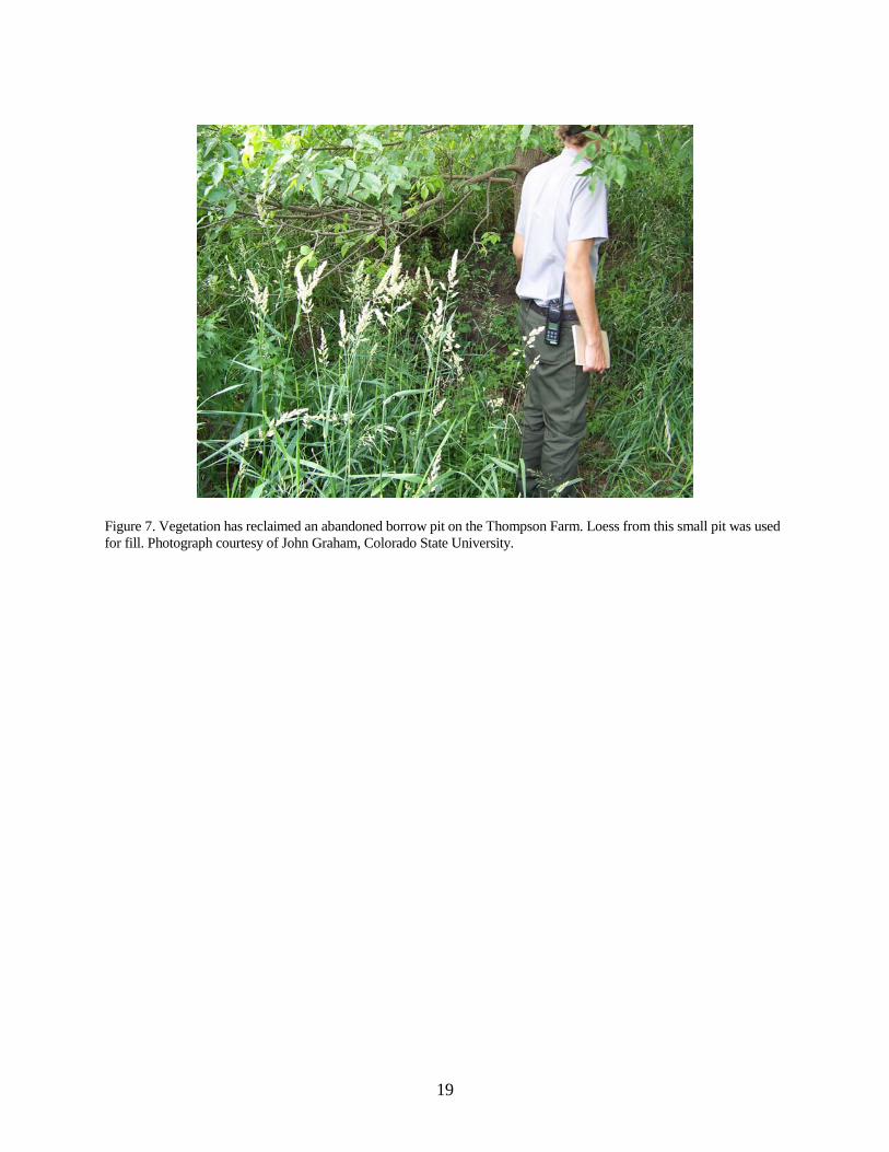
Thompson Farm borrow pit An abandoned borrow pit on the Thompson Farm presents a minor issue for park management. They have submitted a PMIS to restore the Thompson Farm, and the borrow pit lies downslope to the west of the farmhouse. Loess from the pit was used for fill, and the pit has been reclaimed by vegetation (fig. 7).
Features and Processes The following table lists geologic features and processes that were identified at the scoping meeting. These features and processes will be further explained in the GRI report. Table 2: Geologic Features and Processes at Herbert Hoover National Historic Site
Feature/Process Brief Description
Windblown (aeolian)
Deposited about 12,000 to 24,000 years ago by winds out of the northwest, loess of the Peoria Formation is as much as 8 m (25 ft) thick. Tama soil (Iowa’s state soil) developed in the loess. Soils developed in loess account for some of the most fertile soils in the world.
Fluvial (stream) Hoover Creek meanders through the park and includes fluvial geomorphic features such as meander bends, a floodplain, vertical incision, and cut banks.
Glacial Located on the Southern Iowa Drift Plain, the park lies above two pre-Illinoian glacial till units. Younger loess deposits mantle the uplands.
Paleontological Petrified wood was found at 8 m (22 ft) in a well dug in 1983. Pre-Illinoian spruce forests were mowed down by glaciers.
Unique features Loess. Iowa City – Clinton Fault Zone in the subsurface (no evidence of any seismic activity).
Field Trip In the afternoon, scoping participants visited Hoover Creek, Thompson Farm, and Devonian Fossil Gorge, which lies approximately 16 km (10 mi) west of Herbert Hoover National Historic Site. Additional information pertaining to the observations from the field trip will be included in the GRI report. Stop 1: Hoover Creek Characteristics of Hoover Creek were observed from the bridge by the Birthplace Cottage to the bridge by the U.S. Geological Survey stream gage. Geomorphic features and potential geologic issues that were discussed included the following:
• Channel incision: Approximately 3 m (10 ft) in this reach. • Potential flooding: Buildings lie within the Hoover Creek floodplain (fig. 5). • Erosion and bank collapse: A slope that once existed between a drain tile installed in 1994
and the creek has been eroded, causing the drain tile to collapse into the creek (fig. 4B). Undercutting of tree roots. Bank collapse (fig. 4A).

11
• Late Wisconsinan and Holocene alluvial stratigraphy: The Roberts Creek Member and underlying Gunder Member of the DeForest Formation (Bettis III et al. 1992) are exposed beneath the post-settlement surface deposits in the cutbanks (fig. 4A). The Gunder Member represents a drier climate that existed from about 5,500 to 3,000 years ago.
• Retention pond: Proposed to be located in the open area northwest of Hoover Creek and the bridge by the U.S. Geological Survey stream gage.
Stop 2: Thompson Farm The borrow pit at the Thompson Farm is overgrown with grasses and a large tree (fig. 7). The minor excavation into the side hill is almost unnoticeable until stepping off the lip of the pit. About 2 m (6-7 ft) of loess is exposed in the pit. This loess probably caps the entire area. Stop 3: Devonian Fossil Gorge Although not in the park, the Devonian Fossil Gorge, exposed when flood waters swept over the spillway of Coralville Dam in 1993 and 2008, offers a glimpse of the diverse Devonian sea life that populated east-central Iowa and Herbert Hoover National Historic Site approximately 375 million years ago. An outstanding display of the characteristic limestone and fossils, as well as a history of the floods, greets visitors to the Devonian Fossil Gorge (fig. 8), and a self-guided tour and brochure allows them to easily access and understand not only the ancient Devonian environment but also processes that are responsible for the modern landscape. The following general categories capture some of the features observed at the Devonian Fossil Gorge during the field trip:
• Devonian fossils: Stromatoporoid sponges, solitary corals, colonial corals, brachiopods, crinoids, cephalopods, trilobites, bryozoans, placoderms (primitive fish), and worm burrows.
• Geologic structures (post-Devonian): Karst features (dissolution along vertical and horizontal fractures) and cave collapse, fractures (both open and calcite-filled) and faults, folds.
• Dam data: Coralville dam, completed in 1958, was constructed primarily for flood reduction. The outlet has a maximum capacity of 570 cubic meters (20,000 cubic feet) of water per second.
• Flood history: The dam’s maximum capacity was exceeded in 1993 and 2008. The 1993 flood continued for 28 days and washed away a road, campground, and 5 m (17 ft) of soil and rock to expose the Devonian bedrock. The gorge was widened in 2008 when floodwaters poured over the spillway at 550 cubic meters (19,500 cubic feet) per second.
Additional information is available from the following sources:
• University of Iowa Museum of Natural History in Iowa Hall, University of Iowa, Iowa City. • Devonian Fossil Gorge: A Visitor’s guide to Geologic Features at the Coralville Lake
Emergency Spillway by Jean Cutler Prior and available at http://www.igsb.uiowa.edu/ Browse/spillway/spillway.htm (accessed July 1, 2011).
• Devonian Fossil Gorge in the Coralville Dam Emergency Spillway. Fact Sheet, Iowa Department of Natural Resources, Geological and Water Survey, available at ftp://ftp.igsb. uiowa.edu/igspubs/pdf/em-42.pdf (accessed July 1, 2011).
• Witzke, B.J., and B.J. Bunker. 1994. Classic geological exposures, old and new, Coralville Lake and spillway. Guidebook 60. Geological Society of Iowa, Iowa City, Iowa, USA.
12
References Bettis III, E.A., R.G. Baker, W.R. Green, M.K. Whelan, and D.W. Benn. 1992. Late Wisconsinan
and Holocene alluvial stratigraphy, paleoecology, and archaeological geology of east-central Iowa. Guidebook 12, Iowa Geological & Water Survey, Iowa City, Iowa, USA.
Bettis III, E.A., S. Tassier-Surine, and D.J. Quade. 2010. Quaternary geology of the Iowa City area.
Pages 143-161 in T. Marshall and C.L. Fields, editors. The geology of Klein and Conklin quarries, Johnson County, Iowa. Guidebook 87, Geological Society of Iowa, Iowa City, Iowa, USA.
Christianson, D. 2004. Herbert Hoover flood inundation mapping and flood frequency report.
Unpublished report. U.S. Geological Survey, Reston, Virginia, USA. Available at (http://www.nps.gov/heho/naturescience/hydrologicactivity.htm). Accessed July 14, 2011.
Hallberg, G.R. 1980. Pleistocene stratigraphy in east-central Iowa. Technical Information Series
TIS-10, Iowa Geological & Water Survey, Iowa City, Iowa, USA. Hallberg, G.R., N.C. Wollenhaupt, and J.T. Wickham. 1980. Pre-Wisconsinan stratigraphy in
southeast Iowa. Pages 1-110 in G.R. Hallberg, editor. Illinoian and Pre-Illinoian stratigraphy of southeast Iowa and adjacent Illinois. Technical Information Series TIS-11, Iowa Geological & Water Survey, Iowa City, Iowa, USA.
Hallberg, G.R., T.J. Kemmis, N.C. Wollenhaupt, S.P. Esling, E.A. Bettis III, and T.J. Bicki. 1984.
The overburden: Quaternary stratigraphy of the Conklin Quarry. Pages 25-62 in B.J. Bunker and G.R. Hallberg, editors. Underburden-overburden, an examination of Paleozoic and Quaternary strata at the Conklin Quarry near Iowa City. Guidebook 41, Geological Society of Iowa, Iowa City, Iowa, USA.
Kemmis, T.J., E.A. Bettis III, and G.R. Hallberg. 1992. Quaternary geology of Conklin Quarry.
Guidebook 13, Iowa Geological & Water Survey, Iowa City, Iowa, USA. Mickelson, D.M., and P.M. Colgan. 2004. The southern Laurentide Ice Sheet. Pages 1-17 in A.R.
Gillespie, S.C. Porter, and B.F. Atwater, editors. The Quaternary Period in the United States. Developments in Quaternary Science 1, Elsevier, New York, New York, USA.
National Park Service. 2006. Final Hoover Creek stream management plan and environmental
impact statement. U.S. Department of Interior, National Park Service, Washington, D.C. National Park Service. 2011. Hydrologic activity. Herbert Hoover National Historic Site webpage.
(http://www.nps.gov/heho/naturescience/hydrologicactivity.htm). Accessed July 14, 2011. Roy, M., P.U. Clark, R.W. Barendregt, J.R. Glasmann, and R.J. Enkin. 2004. Glacial stratigraphy
and paleomagnetism of late Cenozoic deposits of the north-central United States. Geological Society of America Bulletin 116:30-41.
13
Smith, R.N., M.H. Harding, and T. Walch. 2007. Herbert Hoover presidential library-musuem.
Herbert Hoover Presidential Library Association, West Branch, Iowa, USA. Witzke, B.J. 1981. Silurian stratigraphy of eastern Linn and western Jones counties, Iowa.
Guidebook 35, Geological Society of Iowa, Iowa City, Iowa, USA. Witzke, B.J., and B.J. Bunker. 2006. Stratigraphy of the Wapsipinicon Group (Middle Devonian) in
southeastern Iowa. Pages 47-58 in J. Day, J. Luczaj, and R. Anderson, editors. New perspectives and advances in the understanding of Lower and Middle Paleozoic epeiric carbonate depositional systems in Iowa and Illinois. Guidebook 26, Iowa Geological Survey, Iowa City, Iowa, USA.
Witzke, B.J., R.R. Anderson, and B.J. Bunker. 2004. Bedrock geology of southeast Iowa, digital
geologic map of Iowa, phase 7: southeast Iowa. Iowa Geological & Water Survey Open-File Map OFM-04-01 (scale 1;250,000).
Witzke, B.J., B.J. Bunker, and F.S. Rogers. 1988. Eifelian through lower Frasnian stratigraphy and
deposition in the Iowa area, Midcontinent, USA. Pages 221-250 in N.J. McMillan, A.F. Embry, and D.J. Glass, editors. Devonian of the world. 2nd International Symposium Devonian System, Canada Society of Petroleum Geologists, Calgary, Canada.
Table 3. Scoping Meeting Participants Name Affiliation Position Phone E-Mail
Ray Anderson Iowa Geological and Water Survey Geologist 319-335-1575 [email protected]
Andrea Croskrey NPS Geologic Resources Division Geologist/GIS Analyst 303-8821115 [email protected]
Michael Edwards Herbert Hoover National Historic Site Gardener 319-643-7859 [email protected]
John Graham Colorado State University
Geologist and GRI Report Writer
Bruce Heise NPS Geologic Resources Division
Geologist and GRI Program Coordinator 303-969-2017 [email protected]
John Holding Herbert Hoover National Historic Site Biological Technician 319-643-7858 [email protected]
Daris Honemann Herbert Hoover National Historic Site Maintenance Mechanic 319-643-7871 [email protected]
Mari Mathews Herbert Hoover National Historic Site Administration NA NA
Deb Patty Herbert Hoover National Historic Site Administration NA NA
Deborah Quade Iowa Geological and Water Survey Supervisor.Geologist GW 319-335-1491 [email protected]
Pete Swisher Herbert Hoover National Historic Site Superintendent 319-643-7870 [email protected]
Stephanie Tassier-Surine
Iowa Geological and Water Survey Geologist 319-335-3679 [email protected]
Cary Wiesner Herbert Hoover National Historic Site Historian 319-643-7861 [email protected]
14
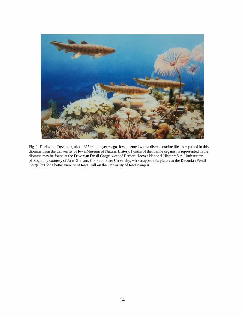
Fig. 1. During the Devonian, about 375 million years ago, Iowa teemed with a diverse marine life, as captured in this diorama from the University of Iowa Museum of Natural History. Fossils of the marine organisms represented in the diorama may be found at the Devonian Fossil Gorge, west of Herbert Hoover National Historic Site. Underwater photography courtesy of John Graham, Colorado State University, who snapped this picture at the Devonian Fossil Gorge, but for a better view, visit Iowa Hall on the University of Iowa campus.
15
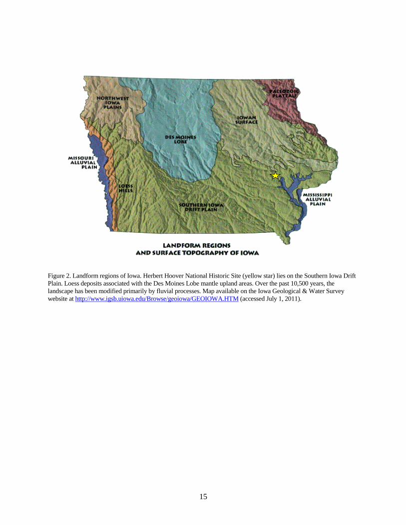
Figure 2. Landform regions of Iowa. Herbert Hoover National Historic Site (yellow star) lies on the Southern Iowa Drift Plain. Loess deposits associated with the Des Moines Lobe mantle upland areas. Over the past 10,500 years, the landscape has been modified primarily by fluvial processes. Map available on the Iowa Geological & Water Survey website at http://www.igsb.uiowa.edu/Browse/geoiowa/GEOIOWA.HTM (accessed July 1, 2011).
16
A) Slumping along the bank of Hoover Creek
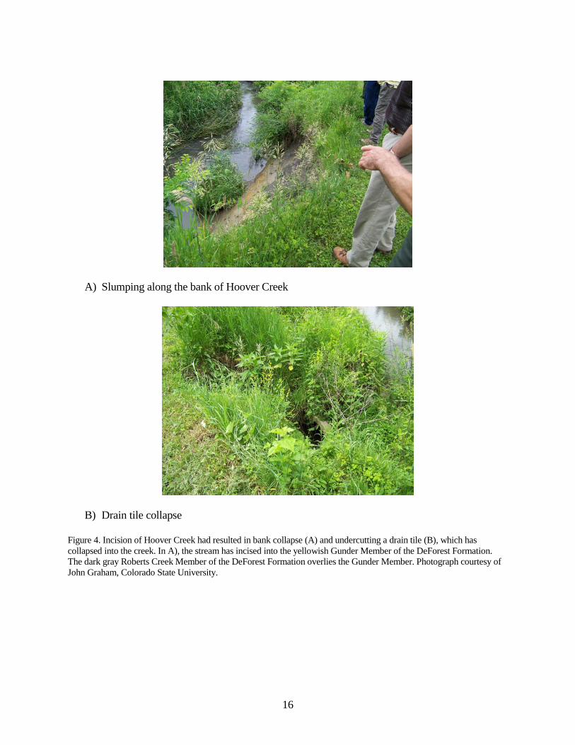
B) Drain tile collapse Figure 4. Incision of Hoover Creek had resulted in bank collapse (A) and undercutting a drain tile (B), which has collapsed into the creek. In A), the stream has incised into the yellowish Gunder Member of the DeForest Formation. The dark gray Roberts Creek Member of the DeForest Formation overlies the Gunder Member. Photograph courtesy of John Graham, Colorado State University.
17
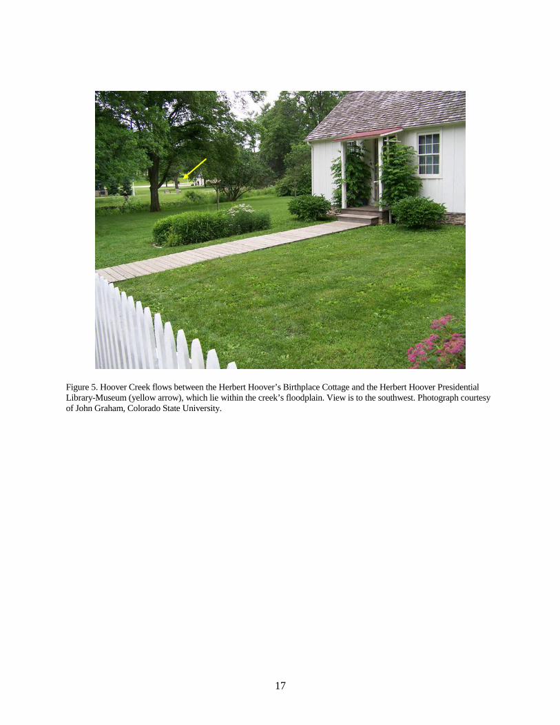
Figure 5. Hoover Creek flows between the Herbert Hoover’s Birthplace Cottage and the Herbert Hoover Presidential Library-Museum (yellow arrow), which lie within the creek’s floodplain. View is to the southwest. Photograph courtesy of John Graham, Colorado State University.

18
Figure 6. Flood waters in 2008 approach the Herbert Hoover Birthplace Cottage. National Park Service photograph.
19
Figure 7. Vegetation has reclaimed an abandoned borrow pit on the Thompson Farm. Loess from this small pit was used for fill. Photograph courtesy of John Graham, Colorado State University.

20
Figure 8. Part of the display that greets visitors to the Devonian Fossil Gorge, Coralville Dam Emergency Spillway. This polished slab of Devonian limestone illustrates the internal structure of stromatoporoid sponges, one of many marine organisms exposed in the Devonian Fossil Gorge.