Embed Size (px)
Citation preview
A scientific collaboration between the Department of Agriculture, Water and the Environment, Bureau of Meteorology, CSIRO and Geoscience Australia
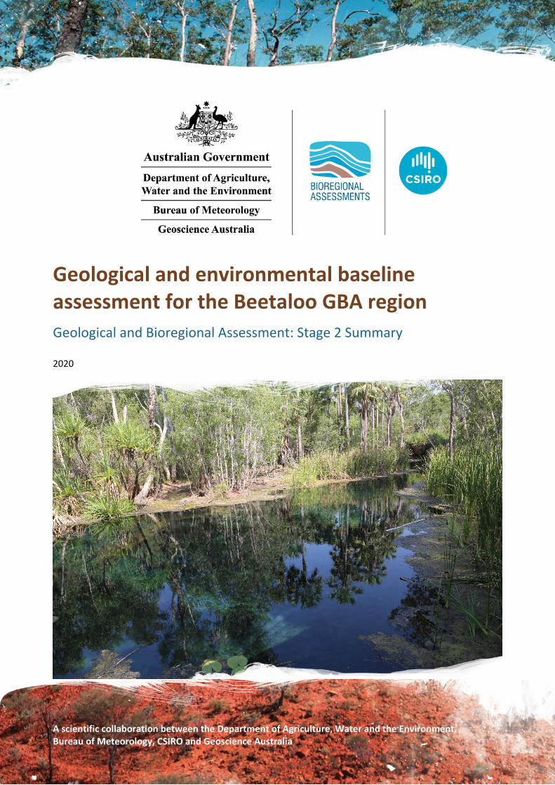
Geological and environmental baseline assessment for the Beetaloo GBA region Geological and Bioregional Assessment: Stage 2 Summary
2020

v30062021
The Geological and Bioregional Assessment Program
The Geological and Bioregional Assessment Program will provide independent scientific advice on the potential impacts from development of selected unconventional hydrocarbon plays on water and the environment. The geological and environmental data and tools produced by the Program will assist governments, industry, landowners and the community to help inform decision making and enhance the coordinated management of potential impacts.
The Program is funded by the Australian Government Department of the Environment and Energy. The Department of the Environment and Energy, Bureau of Meteorology, CSIRO and Geoscience Australia are collaborating to undertake geological and bioregional assessments. For more information, visit http://www.bioregionalassessments.gov.au.
Department of the Environment and Energy
The Department designs and implements Australian Government policy and programs to protect and conserve the environment, water and heritage, promote climate action, and provide adequate, reliable and affordable energy. For more information visit http://www.environment.gov.au.
Bureau of Meteorology The Bureau of Meteorology is Australia’s national weather, climate and water agency. Under the Water Act 2007, the Bureau is responsible for compiling and disseminating Australia's water information. The Bureau is committed to increasing access to water information to support informed decision making about the management of water resources. For more information, visit http://www.bom.gov.au/water/.
CSIRO Australia is founding its future on science and innovation. Its national science agency, CSIRO, is a powerhouse of ideas, technologies and skills for building prosperity, growth, health and sustainability. It serves governments, industries, business and communities across the nation. For more information, visit http://www.csiro.au.
Geoscience Australia Geoscience Australia is Australia’s national geoscience agency and exists to apply geoscience to Australia’s most important challenges. Geoscience Australia provides geoscientific advice and information to the Australian Government to support current priorities. These include contributing to responsible resource development; cleaner and low emission energy technologies; community safety; and improving marine planning and protection. The outcome of Geoscience Australia’s work is an enhanced potential for the Australian community to obtain economic, social and environmental benefits through the application of first-class research and information. For more information, visit http://www.ga.gov.au.
ISBN-PDF 978-1-76003-274-6
Citation Huddlestone-Holmes CR, Frery E, Wilkes P, Bailey AHE, Bernadel G, Brandon C, Buchanan S, Cook SB, Crosbie RS, Evans T, Golding L, Gonzalez D, Gunning ME, Hall LS, Henderson B, Herr A, Holland K, Jarrett A, Kear J, Kirby J, Lech M, Lewis S, Macfarlane C, Martinez J, Northover S, Murray J, O’Grady A, Orr ML, Owens R, Pavey C, Post D, Sundaram B, Rachakonda P, Raiber M, Ransley T, Tetreault-Campbell S and Wang L (2020) Geological and environmental baseline assessment for the Beetaloo GBA region. Geological and Bioregional Assessment Program: Stage 2 Summary. Department of the Environment and Energy, Bureau of Meteorology, CSIRO and Geoscience Australia, Australia.
Authorship is listed alphabetically after the basin leader, second author and former basin leader.
On 1 February 2020 the Department of the Environment and Energy and the Department of Agriculture merged to form the Department of Agriculture, Water and the Environment. Work for this document was carried out under the then Department of the Environment and Energy. Therefore, references to both departments are retained in this report.
Copyright
© Commonwealth of Australia 2020 With the exception of the Commonwealth Coat of Arms and where otherwise noted, all material in this publication is provided under a Creative Commons Attribution 4.0 International Licence https://creativecommons.org/licenses/by/4.0/. The Geological and Bioregional Assessment Program requests attribution as ‘© Commonwealth of Australia (Geological and Bioregional Assessment Program http://www.bioregionalassessments.gov.au)’.
Disclaimer The information contained in this report is based on the best available information at the time of publication. The reader is advised that such information may be incomplete or unable to be used in any specific situation. Therefore, decisions should not be made based solely on this information or without seeking prior expert professional, scientific and technical advice. The Geological and Bioregional Assessment Program is committed to providing web accessible content wherever possible. If you are having difficulties with accessing this document please contact [email protected].
Cover photograph Mataranka Thermal Pools, Beetaloo GBA extended region, October 2018 Credit: Alf Larcher (CSIRO) Element: GBA-BEE-2-381

Geological and environmental baseline assessment for the Beetaloo GBA region: Summary | 1
At a glance The $35.4 million Geological and Bioregional Assessment Program is assessing the potential environmental impacts of shale and tight gas resource development to inform regulatory frameworks and management approaches. The geological and environmental baseline assessment for the Beetaloo GBA region (Stage 2) evaluates the available data, knowledge and conceptual models that are the building blocks for the impact analysis and considerations for management approaches (Stage 3). The Beetaloo GBA region (Figure 1) is located about 500 km south-east of Darwin between Katherine and Tennant Creek and hosts potentially significant gas resources.
Geology and gas resources: Areas of higher prospectivity for shale gas, tight gas and shale oil include the Kyalla and Velkerri formations within the Mesoproterozoic Roper Group and the Hayfield mudstone. This is consistent with the location of recent exploration activity.
Figure 1 The Beetaloo GBA region and Beetaloo GBA extended region Element: GBA-BEE-2-295
Groundwater: The Cambrian Limestone Aquifer (CLA) system is an important groundwater resource with water quality suitable for agricultural, domestic and industrial uses. The Mesoproterozoic Roper Group, prospective for oil and gas, is not accessed for groundwater due to its depth and poor water quality.
Surface water: Most streams in the region are ephemeral and only flow in response to wet season rains. Baseflow from groundwater supports the Roper River and important wetlands such as Mataranka Thermal Pools and Limmen Bight (Port Roper) Tidal Wetlands System.
Water availability: NT legislation prohibits the use of surface water for unconventional petroleum industry activities and groundwater extraction must be licensed. Groundwater and produced water from future unconventional resource extraction are possible water sources that need further investigation.
Potential hydrological connections: The characteristics of the Kyalla and Velkerri formations within the Roper Group are likely to impede connections between the petroleum resource and groundwater. Possible connections between the Hayfield mudstone and overlying groundwater systems will be investigated in Stage 3.
Protected matters: National and NT protected matters were documented and prioritised based on the importance of the Beetaloo GBA extended region to the matter. Detailed assessments (priority 1) in Stage 3 will focus on five protected species (four nationally listed, one territory listed), two nationally important wetlands and groundwater-dependent ecosystems.
Regional-scale assessment (priority 2) will focus on landscape classes based on conceptual models of how landscapes function ecologically. The Beetaloo GBA region was categorised into six landscape classes, dominated by the ‘loamy and sandy plains’ and ‘clay plains’ landscape classes.
Potential impacts: The impact and risk assessment approach uses hazard identification as a first step. Around 180 hazards were identified and appraised using causal pathways, the logical chain of events that links unconventional gas resource development with potential impacts on water and the environment. Thirteen causal pathways were identified and 11 of these were appraised as requiring further assessment.
In Stage 3 the links between these 11 causal pathways and potential impacts will be investigated. For example, do unconventional petroleum resource development activities change groundwater quality and availability, fragment habitats and/or introduce invasive species?

2 | Geological and environmental baseline assessment for the Beetaloo GBA region: Summary
The Geological and Bioregional Assessment Program The GBA Program is undertaking independent scientific studies in three geological basins: the Cooper Basin in Queensland and SA, the Isa Superbasin in Queensland and the Beetaloo Sub-basin in NT. These scientific studies are being conducted by CSIRO and Geoscience Australia, supported by the Bureau of Meteorology and managed by the Department of Agriculture, Water and the Environment. They aim to provide baseline information that:
identifies and evaluates areas of high potential for shale and tight gas for future resource development and any potential connections with water resources
collates and summarises key information about geological structure, groundwater movement through geological layers, surface water systems and ecological systems
evaluates possible ways that unconventional gas resource development might impact the things we value, such as the Cambrian Limestone Aquifer (CLA), groundwater, protected species, as well as culturally and ecologically important matters
User panels
Each assessment is informed by a user panel, where user needs and Program findings are discussed, and information is shared. The user panel in the Beetaloo GBA region consists of representatives from relevant local governments, natural resource management bodies, NT Government representatives, Traditional Owner groups, industry and other land user groups. The Program provides stakeholders with scientific information on the potential impacts of future shale gas, tight gas and shale oil resource development in their region, helping to inform environmental decision making and future management approaches.
About this report
This summary report synthesises knowledge about the geology and prospectivity of shale gas, tight gas and shale oil resources, water resources, protected matters (environmental and cultural) and risks to water (quantity and quality) and the environment in the Beetaloo GBA region. Each section is colour coded to correspond to Figure 2.
Figure 2 Geological and environmental baseline assessment report structure Element: GBA-BEE-2-003

Geological and environmental baseline assessment for the Beetaloo GBA region: Summary | 3
Stage 2 summ
ary: Baseline synthesis and gap analysis
About the region
The Beetaloo GBA region (Figure 1 and Figure 3) is located about 500 km south of Darwin and is sparsely populated, with Daly Waters and Elliott the most populated settlements. The Beetaloo GBA region has been defined specifically for GBA purposes as the geological Beetaloo Sub-basin defined by the Northern Territory Geological Survey and covers an area of about 28,000 km2 in the NT. Additionally, the Beetaloo GBA extended region is also used throughout this report to allow potential environmental and hydrological impacts immediately adjacent to the region boundary to be investigated. To date, there has been limited exploration for petroleum resources in the Beetaloo Sub-basin, with exploration permits currently operated by Origin Energy, Santos and Pangaea Resources.
The Beetaloo GBA region is located entirely in the tropics of the NT between Katherine and Tennant Creek, with tropical elements in the north and semi-arid elements in the south. The area overlies the extensive Cambrian Limestone Aquifer (CLA) – the principal water resource in the Beetaloo GBA region (Section 3.1 in baseline synthesis and gap analysis (Huddlestone-Holmes et al., 2020)). Most of the Beetaloo GBA region is deeply weathered, consisting of gently undulating plains at elevations of 180 to 260 m above sea level. Surface drainage in most of the Beetaloo GBA region is weakly developed. The region is characterised by soils of low agricultural potential, which support natural pastures used primarily for beef cattle production (Section 1.2 in baseline synthesis and gap analysis (Huddlestone-Holmes et al., 2020)).
Fewer than 500 people live in the Beetaloo GBA region, with around 1400 in the Beetaloo GBA extended region, over 700 of whom are Aboriginal or Torres Strait Islander people. More than 90% of the land area is perpetual pastoral leasehold. Native title has been determined to exist for the majority of these leases, and the remainder are under application. The Wubalawun, Mangarrayi and Murranji Aboriginal Land Trusts are all partially within the Beetaloo GBA region and the Alawa, Gurungu, Marlinja, Dillinya, Karlantijpa and Mambaliya Rrumburriya Wuyaliya Aboriginal Land Trusts are within, partially within or immediately adjacent to the Beetaloo GBA extended region.
The emerging shale gas, tight gas and shale oil industry is regulated at federal, state and local levels to ensure that industry development is sustainable and responsible and minimises impacts on environmental and social values. The development and regulation of a petroleum industry targeting onshore unconventional resources is a contentious matter in the NT. There have been two inquiries into hydraulic fracturing activities in the petroleum industry in the NT over the last five years: the Hawke inquiry (Hawke, 2014) and the Pepper inquiry (Pepper et al., 2018). These inquiries have found that if the recommendations, including significant changes to the regulatory framework, are implemented then risks will be reduced to an acceptable level. The NT government placed a moratorium on hydraulic fracturing in 2016 while the Pepper inquiry was conducted. The NT Government has since lifted the moratorium on hydraulic fracturing and committed to implementing all of the Pepper inquiry’s recommendations, which include significant changes to the regulatory framework for petroleum activities in the NT (Section 1.5.2.1 in baseline synthesis and gap analysis (Huddlestone-Holmes et al., 2020)).

4 | Geological and environmental baseline assessment for the Beetaloo GBA region: Summary
Stag
e 2
sum
mar
y: B
asel
ine
synt
hesis
and
gap
ana
lysis
Figure 3 The Beetaloo GBA region, which corresponds to the geological limits of the Beetaloo Sub-basin, and Beetaloo GBA extended region defined for the geological and bioregional assessment of the Beetaloo GBA region Data: Geological and Bioregional Assessment Program (2018a) Element: GBA-BEE-2-157

Geological and environmental baseline assessment for the Beetaloo GBA region: Summary | 5
Stage 2 summ
ary: Baseline synthesis and gap analysis
Geology and gas resources
The Beetaloo Sub-basin is a structural component of the greater McArthur Basin in the NT (Figure 3) and contains a succession of Mesoproterozoic Roper Group sediments more than 5000 m thick that were deposited over 1000 million years ago. The Beetaloo Sub-basin represents a broad depression bounded by several prominent structural highs, and it is divided into eastern and western elements by the Daly Waters High (Figure 4; Section 2.1 in baseline synthesis and gap analysis (Huddlestone-Holmes et al., 2020); geology technical appendix (Orr et al., 2020)). Overlying sedimentary basins include the Georgina, Wiso and Daly basins and the Mesozoic Carpentaria Basin.
The Beetaloo Sub-basin is prospective for unconventional hydrocarbons and is estimated to contain significant technically recoverable unconventional petroleum resources. Plays most likely to be developed in a five- to ten-year time frame include shale plays in the Kyalla Formation and the Amungee Member of the Velkerri Formation, along with a tight sandstone play in the Hayfield sandstone member of the Hayfield mudstone. Production testing at the Amungee NW-1H exploration well in October 2016, which was reported by Origin Energy in 2017, showed that 6.6 trillion cubic feet (Tcf) of contingent gas resource may be present within the organic-rich shales of the Velkerri Formation (Section 2.2 in baseline synthesis and gap analysis (Huddlestone-Holmes et al., 2020); petroleum prospectivity technical appendix (Hall et al., 2020)).
Characterisation of the hydrocarbons present within the plays in the Beetaloo GBA region was undertaken to support further work on understanding likely development scenarios in Stage 3. Results show that the Amungee Member of the Velkerri Formation is potentially prospective for either liquids-rich or dry gas over most of the Beetaloo Sub-basin extent (Figure 5; Section 2.2 in baseline synthesis and gap analysis (Huddlestone-Holmes et al., 2020); petroleum prospectivity technical appendix (Hall et al., 2020)). The Kyalla Formation liquids-rich gas play and the Hayfield sandstone member liquids-rich gas/oil play are likely to be restricted to the central part of the eastern sub-basin (Figure 5). The mapped depth and extent of these plays inform where the plays are most likely to be present within the Beetaloo GBA region and inform the likely development scenarios. Liquids-rich gas resources are currently more favourable to develop from an economic perspective. These results in turn inform the assessment of potential impacts on associated assets at the surface and overlying surface water – groundwater systems. If and how an unconventional play is developed will be dependent on its economic viability, along with other cultural and environmental considerations.

6 | Geological and environmental baseline assessment for the Beetaloo GBA region: Summary
Stag
e 2
sum
mar
y: B
asel
ine
synt
hesis
and
gap
ana
lysis
Figure 4 Structural elements map of the Beetaloo Sub-basin showing major faults, overlain on the total sediment thickness from the base of the Mesoproterozoic Roper Group to the surface The thick black lines show the location of faults mapped from surface outcrop. The dashed lines represent faults and lineaments primarily interpreted from gravity and magnetics data. The extent and nature of these structures is much more uncertain and further work more detailed mapping work using seismic data is required. In addition, it is likely that not all faults intersecting the Beetaloo Sub-basin stratigraphy have yet been mapped and the number of recognised faults in a basin tends to increase substantially as more information (higher resolution and three-dimensional seismic etc.) becomes available over time. Contour interval (C.I.) = 500 m Data: major faults and sediment thickness from Frogtech Geoscience (2018); structural elements from Plumb and Wellman (1987), Silverman et al. (2007) and Munson (2016) Element: GBA-BEE-2-080

Geological and environmental baseline assessment for the Beetaloo GBA region: Summary | 7
Stage 2 summ
ary: Baseline synthesis and gap analysis
Figure 5 Play fairway maps showing the variation in relative prospectivity of different petroleum resource play types across the Beetaloo Sub-basin (a) Amungee Member dry gas play, (b) Amungee Member liquids-rich gas play, (c) Kyalla Formation liquids-rich gas play and (d) Hayfield sandstone member liquids play Source: petroleum prospectivity technical appendix (Hall et al., 2020) and Côté et al. (2018) Data: Geological and Bioregional Assessment Program (2019a) Element: GBA-BEE-2-106

8 | Geological and environmental baseline assessment for the Beetaloo GBA region: Summary
Stag
e 2
sum
mar
y: B
asel
ine
synt
hesis
and
gap
ana
lysis
Understanding conventional and unconventional gas
Conventional natural gas (and oil) occurs in discrete accumulations trapped by a geological structure and/or stratigraphic feature, typically bounded by a down-dip contact with water and capped by impermeable rock.
Conventional petroleum was not formed in-situ; it migrated from the deeper source rocks into a trap containing porous and permeable reservoir rocks (Schmoker, 2002; Schmoker et al., 1995) (see 1 in Figure 6).
Unconventional gas is found in a range of geological settings and includes shale gas, tight gas and deep coal gas. Unlike conventional reservoirs, unconventional reservoirs have low permeabilities and require innovative technological solutions to move the trapped hydrocarbons to the surface (see 2 in Figure 6).
Figure 6 Schematic showing some of the types of oil and gas accumulations The ‘oil window’ refers to the maturity range in which oil is generated from oil-prone organic matter. Below is the ‘gas window’, which refers to the maturity range in which gas is generated from organic matter. Source: after Schenk and Pollastro (2002); Cook et al. (2013); Schmoker et al. (1995) Element: GBA-BEE-2-148

Geological and environmental baseline assessment for the Beetaloo GBA region: Summary | 9
Stage 2 summ
ary: Baseline synthesis and gap analysis
Water resources – groundwater
The hydrogeology of the Beetaloo GBA region is conceptualised as three individual groundwater subsystems: (i) Neoproterozoic rocks and overlying Cambrian Antrim Plateau Volcanics – water quality unknown for Neoproterozoic rocks, generally good for Antrim Plateau Volcanics; (ii) the CLA system – water quality good; and (iii) Cretaceous Carpentaria Basin and Cenozoic sediments – where saturated water quality can be moderately saline (Figure 7). Those components are underlain by the sedimentary rocks of the Roper Group, hosting the key unconventional hydrocarbon resources, which, for the most part, is an aquitard. The most significant and documented of these subsystems is the CLA due to its importance as a water source for the pastoral industry and community, as well as for the presence of karst systems that may cause local groundwater flow paths to substantially deviate from the regional flow (Figure 8; Section 3.1 in baseline synthesis and gap analysis (Huddlestone-Holmes et al., 2020); hydrogeology technical appendix (Evans et al., 2020)).
Water resources – potential hydrological connections
For potential hydrological connections between the prospective petroleum resource and groundwater, consideration is given to three connectivity issues associated with (i) gas and petroleum production from prospective Roper Group formations, whereby impacts could propagate to overlying groundwater systems; (ii) extracting groundwater from units above the Roper Group to use in petroleum resource development, where impacts may spread to existing groundwater users and the environment through shallow groundwater systems; and (iii) shallow aquifers (e.g. karst features in the CLA) enabling migration of contamination due to infiltration of surface spills from petroleum resource development or production (Section 3.4 in baseline synthesis and gap analysis (Huddlestone-Holmes et al., 2020)).
Five potential hydrological connections are postulated for the Beetaloo GBA region (Table 1; Section 3.4 in baseline synthesis and gap analysis (Huddlestone-Holmes et al., 2020); hydrogeology technical appendix (Evans et al., 2020)). Hydrochemistry and dissolved gas concentrations from the CLA provide some evidence of existing hydrological connectivity with deeper formations. However, the assessment also highlights that considerable data and knowledge gaps exist (Section 3.6 in baseline synthesis and gap analysis (Huddlestone-Holmes et al., 2020)), including for springs associated with aquifers of Proterozoic age.
Local investigations relevant to risks from future shale gas, tight gas and shale oil resource development will be undertaken in Stage 3 to obtain a better understanding of potential connections (Section 3.6.1 in baseline synthesis and gap analysis (Huddlestone-Holmes et al., 2020)).

10 | Geological and environmental baseline assessment for the Beetaloo GBA region: Summary
Stag
e 2
sum
mar
y: B
asel
ine
synt
hesis
and
gap
ana
lysis
Figure 7 Conceptual hydrogeological model for the Beetaloo GBA region This conceptual diagram (not to scale) depicts the hydrostratigraphy across the Beetaloo GBA region. The Mesoproterozoic Roper Group hosts two prospective formations for tight gas and shale gas (Velkerri and Kyalla formations), which are separated by the Moroak Sandstone, which is also prospective. Overlying the Roper Group are the Neoproterozoic sequences, of which the Hayfield Mudstone acts as a regional seal (aquitard) for underlying sequences. At shallower levels, another regional aquitard, the Antrim Plateau Volcanics, for the most part separates underlying sequences from the Cambrian Limestone Aquifer. This in turn is overlaid and in places confined the Cretaceous sequence. Cenozoic sediments are not shown. Source: hydrogeology technical appendix (Evans et al., 2020) Element: GBA-BEE-2-325

Geological and environmental baseline assessment for the Beetaloo GBA region: Summary | 11
Stage 2 summ
ary: Baseline synthesis and gap analysis
Figure 8 Regional groundwater flow in the Cambrian Limestone Aquifer system Data: regional watertable contours and flow arrows after Fulton and Knapton (2015); limestone extent from Department of Environment and Natural Resources (NT) (2018); limestone subcrop from Department of Environment and Natural Resources (NT) (2008) Element: GBA-BEE-2-086

12 | Geological and environmental baseline assessment for the Beetaloo GBA region: Summary
Stag
e 2
sum
mar
y: B
asel
ine
synt
hesis
and
gap
ana
lysis
Table 1 Summary of potential hydrological connections and potential impacts on water and the environment.
Potential hydrological connections Potential impacts on water and the environment
① Direct stratgraphic contact Potential connection via direct stratigraphic contact between shale and tight gas plays in the Roper Group and adjacent aquifers Jamison sandstone (JS), Bukalara Sandstone, Antrim Plateau Volcanics or the Cambrian Limestone Aquifer (CLA).
Water bores that access Antrim Plateau Volcanics, the CLA and the shallower groundwater systems associated with Carpentaria Basin (CB) and Cenozoic deposits, surface water bodies (including Lake Woods), waterholes (e.g. Grainger Hole, Mungabroom and Chowyung Waterholes), GDEs and springs
② Faults Potential connection through deep-seated faults striking shale gas reservoirs in the Velkerri and Kyalla formations and adjacent /overlying aquifers
Antrim Plateau Volcanics, CLA aquifer, springs and associated surface water bodies
③ Aquifers Potential connection through the porous aquifers of Moroak Sandstone, Jamison sandstone, UN, CB and alluvium and karstic systems of CLA (GRF+ALF)
Water bores that access these aquifers and potentially associated springs
④ Partial aquitards Migration through aquitards into the CLA and basal sandstone zones of Carpentaria Basin (CB)
Water bores in the aquifer systems Undifferentiated Neoproterozoic (UN e.g. Bukalara Sandstone), CLA and saturated sandstone found in the base of CB
⑤ Groundwater discharge Migration through the karstic CLA aquifer into springs and associated surface water bodies
Springs that source water from CLA aquifer, including associated surface water bodies and groundwater-dependent ecosystems Users of groundwater from the CLA.
ALF = Anthony Lagoon Formation and equivalents (upper CLA); CB = Carpentaria Basin; CLA = Cambrian Limestone Aquifers; GDE = groundwater-dependent ecosystem; GRF = Gum Ridge Formation and equivalents (lower CLA); UN = undifferentiated Proterozoic
Water resources – surface water – groundwater conceptualisation
Surface water systems of the Beetaloo GBA region consist of five surface water catchments: the Roper River, Daly River, Limmen Bight River, the Wiso region and the Barkly region (Figure 9). The Roper (44%) and Wiso (47%) cover the majority of the region (Section 3.2 in baseline synthesis and gap analysis (Huddlestone-Holmes et al., 2020)). There are no permanent streams within the Beetaloo GBA region; however, the groundwater discharge from the Beetaloo GBA region supports the perennial flows in the Roper River downstream of the region through discharge at Mataranka Thermal Pools and baseflow to streams in Elsey National Park. In the Beetaloo GBA extended region lie wetlands listed in A directory of important wetlands in Australia (DIWA): Mataranka Thermal Pools, Limmen Bight (Port Roper) Tidal Wetlands System in the Roper Basin, and Lake Woods in the Wiso region. Water quality is considered fair to good quality for drinking water for gauged sites shown in Figure 9.
Investigations of hydrological connection between deeper groundwaters and surface waters reveal that across much of the Beetaloo GBA region the regional watertable lies below the ground surface (generally greater than 20 m), which precludes significant interactions between surface

Geological and environmental baseline assessment for the Beetaloo GBA region: Summary | 13
Stage 2 summ
ary: Baseline synthesis and gap analysis
water features, vegetation and the regional watertable. Connectivity between the surface water and groundwaters is likely to be limited to localised shallow perched aquifer systems, rather than more regional watertables, such as those found in the CLA. Large lakes south of the region (e.g. Lake Woods), when inundated, appear to act as sources of localised recharge to the underlying watertable (Section 3.3 in baseline synthesis and gap analysis (Huddlestone-Holmes et al., 2020)).
Groundwater-dependent ecosystems (GDEs) have been noted in the Beetaloo GBA region (Figure 10) and are mostly limited to shallow perched aquifer systems. Springs have not been identified in the Beetaloo GBA region. However, numerous springs occur in the north of the Beetaloo GBA extended region, where significant groundwater discharge occurs from CLA aquifers to rivers and wetlands, such as Mataranka Thermal Pools and Roper River (Section 3.3 in baseline synthesis and gap analysis (Huddlestone-Holmes et al., 2020); hydrogeology technical appendix (Evans et al., 2020)).
Water resources – potential water sources
Potential water sources for a future unconventional petroleum industry in the Beetaloo GBA region do not include surface water, as the NT Government has prohibited its extraction for this use (Section 3.5.1 in baseline synthesis and gap analysis (Huddlestone-Holmes et al., 2020)). Unallocated water reserves and other strategies in existing groundwater allocation plans do not currently consider the potential quantity of water that may be taken by the petroleum industry. The potential implications for water plans and other water users will be investigated as part of Stage 3 (Section 3.5.2 in baseline synthesis and gap analysis (Huddlestone-Holmes et al., 2020)). Produced water from future unconventional resource extraction is a potential water source for drilling and hydraulic fracturing operations that may be used by resource companies in the Beetaloo GBA region (Section 3.5.2 in baseline synthesis and gap analysis (Huddlestone-Holmes et al., 2020)). Aside from groundwater in the CLA, other sources are being considered, including the potential to use groundwater from deeper aquifers such as the Bukalara and Jamison sandstones.

14 | Geological and environmental baseline assessment for the Beetaloo GBA region: Summary
Stag
e 2
sum
mar
y: B
asel
ine
synt
hesis
and
gap
ana
lysis
Figure 9 River catchments of the Beetaloo GBA region and modelled mean annual runoff using the Australian Water Resource Assessment (AWRA) model AWRC = Australian Water Resources Council Data: CSIRO (2015) Element: GBA-BEE-2-038

Geological and environmental baseline assessment for the Beetaloo GBA region: Summary | 15
Stage 2 summary: Baseline synthesis and gap analysis
Figure 10 Groundwater‐dependent ecosystems in the Beetaloo GBA region and Beetaloo GBA extended region
GDE = groundwater‐dependent ecosystem Data: Bureau of Meteorology (2017) Element: GBA‐BEE‐2‐019

16 | Geological and environmental baseline assessment for the Beetaloo GBA region: Summary
Stag
e 2
sum
mar
y: B
asel
ine
synt
hesis
and
gap
ana
lysis
Protected matters – environmental and cultural assets
Matters of National Environmental Significance (MNES) potentially in the Beetaloo GBA region include 14 threatened species, 13 migratory species and one species that is both threatened and migratory. Other protected matters include 21 listed marine species (mainly birds). Within the Beetaloo GBA extended region there is one threatened ecological community, 15 threatened species, 15 migratory species and two species that are both threatened and migratory. Other protected matters in the Beetaloo GBA extended region comprise 23 listed marine species (mainly birds) and five areas of Commonwealth lands (Section 4.1.1 in baseline synthesis and gap analysis (Huddlestone-Holmes et al., 2020); protected matters technical appendix (Pavey et al., 2020)).
Among Matters of Territory Environmental Significance, one territory reserve – Bullwaddy Conservation Reserve – occurs entirely within the Beetaloo GBA region. A further four reserves are outside the Beetaloo GBA region but are contained entirely within the Beetaloo GBA extended region. Also included among Matters of Territory Environmental Significance are two nationally important wetlands: Mataranka Thermal Pools and Lake Woods. These occur in the Beetaloo GBA extended region. Four species that are classified as threatened under the NT’s Territory Parks and Wildlife Conservation Act but not under the Commonwealth’s Environmental Protection and Biodiversity Conservation Act 1999 (EPBC Act) have been recorded in the Beetaloo GBA region since 1990 and are considered likely to still occur there (Section 4.1.3 in baseline synthesis and gap analysis (Huddlestone-Holmes et al., 2020); protected matters technical appendix (Pavey et al., 2020)).
Among GDEs, springs do not occur within the Beetaloo GBA region but are present within the Beetaloo GBA extended region to the north-north-east and east as discharge complexes from the major northward flowing groundwater systems of the CLA. The springs at Mataranka Thermal Pools sustain dry season flows in the Roper River system and support terrestrial and wetland GDEs. Connectivity between surface water and groundwater is limited within the Beetaloo GBA region because of the depth to groundwater (typically greater than 40 m). Terrestrial GDEs are mostly limited to shallow perched aquifer systems that are fed by groundwater.
Key threatening processes present in the Beetaloo GBA region include competition and land degradation by rabbits and unmanaged goats; predation by European red foxes and feral cats; predation, habitat degradation, competition and disease transmission by feral pigs; novel biota and their impact on biodiversity (e.g. feral horses, donkeys and camels); and biological effects, including lethal toxic ingestion, caused by cane toads.
No socio-economic or cultural assets were identified from searches of the EPBC Act on protected matters. However, the Beetaloo GBA region has supported Indigenous cultures for tens of thousands of years, and communities maintain an ongoing connection to the region. Assessment of impacts on Indigenous values are also managed under Commonwealth (see Section 1.5.1.2 in baseline synthesis and gap analysis (Huddlestone-Holmes et al., 2020)) and Northern Territory (see Section 1.5.2.6 in baseline synthesis and gap analysis (Huddlestone-Holmes et al., 2020)) legislation.

Geological and environmental baseline assessment for the Beetaloo GBA region: Summary | 17
Stage 2 summ
ary: Baseline synthesis and gap analysis
In order to focus the assessment in Stage 3, listed matters were prioritised based on how important the Beetaloo GBA extended region is to each matter (Section 4.4 in baseline synthesis and gap analysis (Huddlestone-Holmes et al., 2020)). Detailed assessments will focus on five protected species (four nationally listed, one territory listed), two nationally important wetlands, and GDEs (priority 1).
Table 2 Prioritisation of listed matters that occur, or potentially occur, in the Beetaloo GBA extended region Priority 1 – Importance of the region to the matter warrants a detailed level of assessment. Priority 2 – Importance of the region to the matter warrants a high-level assessment. Priority 3 – Importance of the region to the matter does not warrant further assessment.
Listing Category Priority 1 Priority 2 Priority 3
Threatened ecological community 0 0 1
Protected species Bird 4 4 22
Mammal 1 3 2
Plant 0 0 0
Fish 0 0 1
Reptile 0 4 3
Invertebrate 0 0 1
Groundwater-dependent ecosystems All 0 0
Listed areas Wetland (national)a,b 2 0 0
Territory Conservation Reserve
0 1 0
Other protected area 0 0 1
Other listed area 0 0 5
Landscape classes N/A N/A • Loamy and sandy plains
• Clay plains • Floodplain and
alluvium • Undulating
country on fine-grained sedimentary rocks
• Tablelands and duricrusts
• Basalt plains and hills
aAlthough outside Beetaloo GBA region, evidence suggests hydrological connectivity. bIncludes Elsey National Park, Lake Woods conservation covenant and Longreach Waterhole protected area which are not listed separately under Territory Conservation Reserve (Elsey National Park) and Other protected area (Lake Woods, Longreach Waterhole). Source: asset dataset (Geological and Bioregional Assessment Program, 2019c)

18 | Geological and environmental baseline assessment for the Beetaloo GBA region: Summary
Stag
e 2
sum
mar
y: B
asel
ine
synt
hesis
and
gap
ana
lysis
Protected matters – landscape classes
The assessment of potential hydrological and environmental impacts due to shale gas, tight gas and shale oil resource development in Stage 3 is underpinned by landscape classifications. The key ecological and hydrological features are categorised into six landscape (Table 3, Figure 11).
The Beetaloo GBA region is dominated by loamy and sandy plains (70%), and by clay plains (17%). There are also substantial areas of floodplain and alluvium (6%), and undulating country on fine-grained sedimentary rocks (5%). There are only traces of tablelands and duricrusts, and basalt plains and hills (Table 3; Section 4.3 in baseline synthesis and gap analysis (Huddlestone-Holmes et al., 2020); protected matters technical appendix (Pavey et al., 2020)).
Sandstone ranges, and hills and lowlands on metamorphic rocks landscape classes, occur just outside the Beetaloo GBA region and are included in Figure 11. No springs occur in the Beetaloo GBA region; however, Mataranka Thermal Pools is situated in the Roper River catchment in Elsey National Park, some 50 km north of the Beetaloo GBA region, and other springs occur within the Beetaloo GBA extended region (Evans et al., 2020).
Table 3 Landscape classes within the Beetaloo GBA region and corresponding Queensland Land Zones
Landscape class Queensland Land Zones
Geological description Area (km2)
Area (%)
Loamy and sandy plains Tertiary – early Quaternary loamy and sandy plains and plateaus
Tertiary – early Quaternary extensive, uniform near-level or gently undulating plains with sandy or loamy soils. Includes dissected remnants of these surfaces. Also includes plains with sandy or loamy soils of uncertain origin; and plateau remnants with moderate to deep soils usually overlying duricrust. Excludes recent Quaternary alluvial systems, exposed duricrust, and soils derived from underlying bedrock. Soils are usually Tenosols and Kandosols, also minor deep sandy surfaced Sodosols and Chromosols. There may be a duricrust at depth.
19,979 70
Clay plains Tertiary – early Quaternary clay plains
Tertiary – early Quaternary clay deposits, usually forming level to gently undulating plains not related to recent Quaternary alluvial systems. Excludes clay plains formed in-situ on bedrock. Mainly Vertosols with gilgai microrelief but includes thin sandy or loamy surfaced Sodosols and Chromosols with the same paleo-clay subsoil deposits.
4,937 17

Geological and environmental baseline assessment for the Beetaloo GBA region: Summary | 19
Stage 2 summ
ary: Baseline synthesis and gap analysis
Landscape class Queensland Land Zones
Geological description Area (km2)
Area (%)
Floodplain and alluvium Recent Quaternary alluvial systems
Recent Quaternary alluvial systems, including closed depressions, paleo-estuarine deposits currently under freshwater influence, inland lakes and associated wave-built lunettes. Excludes colluvial deposits such as talus slopes and pediments. Includes a diverse range of soils, predominantly Vertosols and Sodosols; also with Dermosols, Kurosols, Chromosols, Kandosols, Tenosols, Rudosols and Hydrosols; and Organosols in high rainfall areas.
1,809 6
Undulating country on fine-grained sedimentary rocks
Fine-grained sedimentary rocks
Fine-grained sedimentary rocks, generally with little or no deformation and usually forming undulating landscapes. Siltstones, mudstones, shales, calcareous sediments, and labile sandstones are typical rock types, although minor interbedded volcanics may occur. Includes a diverse range of fine-textured soils of moderate to high fertility, predominantly Vertosols, Sodosols and Chromosols.
1,406 5
Tablelands and duricrusts
Cenozoic duricrustsa Cenozoic duricrusts formed on a variety of rock types, usually forming mesas or scarps. Includes exposed ferruginous, siliceous or mottled horizons and associated talus and colluvium, and remnants of these features – for example, low stony rises on downs. Soils are usually shallow Rudosols and Tenosols, with minor Sodosols and Chromosols on associated pediments, and shallow Kandosols on plateau margins and larger mesas.
383 1
Basalt plains and hills Cenozoic igneous rocks Cenozoic igneous rocks, predominantly flood basalts forming extensive plains and occasional low scarps. Also includes hills, cones and plugs on trachytes and rhyolites, and associated interbedded sediments, and talus. Excludes deep soils overlying duricrust. Soils include Vertosols, Ferrosols and shallow Dermosols.
7 0
Total 28,521 100
Source: Department of Environment and Natural Resources (NT) (2019); adapted from Wilson and Taylor (2012)

20 | Geological and environmental baseline assessment for the Beetaloo GBA region: Summary
Stag
e 2
sum
mar
y: B
asel
ine
synt
hesis
and
gap
ana
lysis
Figure 11 Landscape classes and IBRA regions within the Beetaloo GBA region IBRA regions are also indicated. Note that the landscape classification extends slightly outside the GBA boundary for context and two landscape classes – sandstone ranges, and hills and lowlands on metamorphic rocks – occur just outside the Beetaloo GBA region. Data: Department of Environment and Natural Resources (NT) (2019) Element: GBA-BEE-2-001

Geological and environmental baseline assessment for the Beetaloo GBA region: Summary | 21
Stage 2 summ
ary: Baseline synthesis and gap analysis
Potential impacts due to shale gas, tight gas and shale oil resource development
The risk assessment approach follows the principles for ecological risk assessment outlined by the United States Environmental Protection Agency (1998) and Hayes (2004) to meet regulatory requirements for the Beetaloo GBA region (Figure 12). Identifying causal pathways in Stage 2 is a key component of the identification and formulation step of the GBA impact and risk assessment approach. Prioritised causal pathways will be the focus of the impact and risk assessment, which will be conducted in Stage 3.
Figure 12 Overview of GBA impact and risk assessment approach, connecting hazards from existing and future resource development through causal pathways to potential effects on landscape classes and values that can be assessed as endpoints Links along the conceptual pathway are shown by coloured lines. ‘Hazard’ = an event, or chain of events, that might result in an effect; ‘impact cause’ = an activity (or aspect of an activity) that initiates a hazardous chain of events; ‘impact mode’ = the manner in which a hazardous chain of events (initiated by an impact cause) could result in an effect (change in the quality or quantity of surface water or groundwater); ‘causal pathway’ = the logical chain of events, either planned or unplanned, that link unconventional gas resource development and potential impacts on water and the environment; ‘potential effect’ = specific types of impacts or changes to water or the environment, such as changes to the quantity and/or quality of surface water or groundwater or to the availability of suitable habitat; ‘landscape class’ = a collection of ecosystems with characteristics that are expected to respond similarly to changes in groundwater and/or surface water due to unconventional gas resource development; ‘endpoint’ = includes ‘assessment endpoints’ – an explicit expression of the ecological, economic and/or social values to be protected; ‘measurement endpoints’ = measurable characteristics or indicators related to the assessment endpoint. Data: Geological and Bioregional Assessment Program (2019d) Element: GBA-BEE-2-315
Individual hazards were systematically identified and scored by considering all the possible ways an activity in the life cycle (Figure 13; Section 5.2.2 in baseline synthesis and gap analysis (Huddlestone-Holmes et al., 2020)) of shale gas, tight gas and shale oil resource development may cause impact (Section 5.2 in baseline synthesis and gap analysis (Huddlestone-Holmes et al., 2020)). Hazards that have similar potential impacts are grouped together in causal pathways.
Causal pathways describe the logical chain of events ‒ either planned or unplanned ‒ that link unconventional gas resource development and potential impacts on water and the environment.
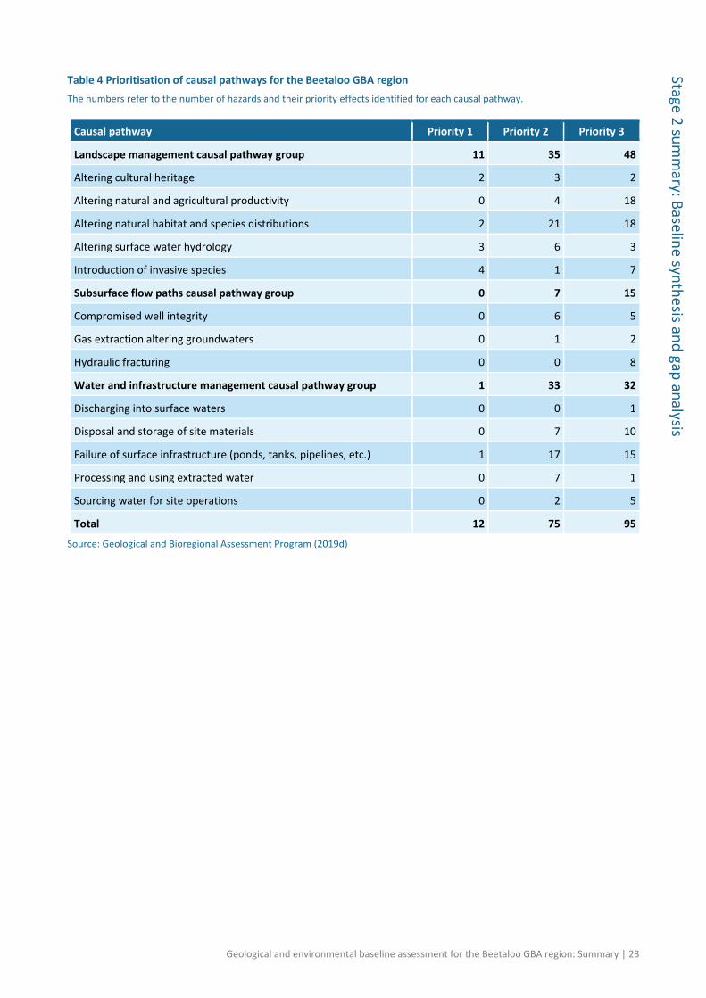
There are 13 causal pathways that are aggregated into three groups (Table 4; Section 5.3 in baseline synthesis and gap analysis (Huddlestone-Holmes et al., 2020)). Causal pathways play a

22 | Geological and environmental baseline assessment for the Beetaloo GBA region: Summary
Stag
e 2
sum
mar
y: B
asel
ine
synt
hesis
and
gap
ana
lysis
central role in the assessment, connecting hazards arising from existing activities (Section 1.4 in baseline synthesis and gap analysis (Huddlestone-Holmes et al., 2020)) and potential unconventional gas resource development activities (Section 5.2 in baseline synthesis and gap analysis (Huddlestone-Holmes et al., 2020)) with the values to be protected (Sections 4.1 and 4.2 in baseline synthesis and gap analysis (Huddlestone-Holmes et al., 2020)) for each landscape class (Section 4.3 in baseline synthesis and gap analysis (Huddlestone-Holmes et al., 2020)). Causal pathways were prioritised for Stage 3: Priority 1, where severity and likelihood warrant a detailed level of assessment; Priority 2, where severity and likelihood warrant high-level assessment; and Priority 3, where severity and likelihood do not warrant further assessment (Table 4). The impact and risk assessment in Stage 3 will assess cumulative impacts and how the hazards in each causal pathway might impact on a suite of endpoints, such as endemic native species, migratory species, ecological communities, wetland ecosystems, water resources, cultural heritage and agriculture (Section 5.3 in baseline synthesis and gap analysis (Huddlestone-Holmes et al., 2020)).
Figure 13 Ten major activities involved in typical shale gas, tight gas and shale oil resource development Source: adapted from Litovitz et al. (2013) Element: GBA-BEE-2-353
Geological and environmental baseline assessment for the Beetaloo GBA region: Summary | 23
Stage 2 summ
ary: Baseline synthesis and gap analysis
Table 4 Prioritisation of causal pathways for the Beetaloo GBA region The numbers refer to the number of hazards and their priority effects identified for each causal pathway.
Causal pathway Priority 1 Priority 2 Priority 3
Landscape management causal pathway group 11 35 48
Altering cultural heritage 2 3 2
Altering natural and agricultural productivity 0 4 18
Altering natural habitat and species distributions 2 21 18
Altering surface water hydrology 3 6 3
Introduction of invasive species 4 1 7
Subsurface flow paths causal pathway group 0 7 15
Compromised well integrity 0 6 5
Gas extraction altering groundwaters 0 1 2
Hydraulic fracturing 0 0 8
Water and infrastructure management causal pathway group 1 33 32
Discharging into surface waters 0 0 1
Disposal and storage of site materials 0 7 10
Failure of surface infrastructure (ponds, tanks, pipelines, etc.) 1 17 15
Processing and using extracted water 0 7 1
Sourcing water for site operations 0 2 5
Total 12 75 95
Source: Geological and Bioregional Assessment Program (2019d)

24 | Geological and environmental baseline assessment for the Beetaloo GBA region: Summary
Stag
e 2
sum
mar
y: B
asel
ine
synt
hesis
and
gap
ana
lysis
Potential impacts from drilling and hydraulic fracturing chemicals and two causal pathways – ‘hydraulic fracturing’ and ‘compromised well integrity’ – were assessed in greater detail because of concern from government, the community and industry.
Potential impacts – screening of drilling and hydraulic fracturing chemicals
The Tier 1 qualitative screening assessed 116 chemicals used between 2011 and 2016 for drilling and hydraulic fracturing at shale, tight and deep coal gas operations in the three GBA regions (chemicals used in shale oil resource developments were not assessed) (Section 6.1 in baseline synthesis and gap analysis (Huddlestone-Holmes et al., 2020); chemical screening technical appendix (Kirby et al., 2020)). About one-third (42 chemicals) were of ‘low concern’ and pose minimal risk to aquatic ecosystems. A further 33 chemicals were of ‘potentially high concern’ and 41 were of ‘potential concern’. The identified chemicals of potential concern and potentially high concern would require further site-specific quantitative chemical assessments to be performed to determine risks from specific gas resource developments to aquatic ecosystems.
Figure 14 Tier 1 qualitative environmental risk assessment of chemicals associated with shale, tight and deep coal gas operations in Australia Refer to Figure 72 in Huddlestone-Holmes et al. (2020) for screens 1 to 4 details. Percentages of chemicals in each category are shown in each segment. Further breakdown of chemicals in each category are shown in each segment. Further breakdown of chemicals of ‘potential concern’ and ‘potentially high concern’ are shown in the smaller coloured circles. P = persistent; B = bioaccumulative; T = toxic Data: Geological and Bioregional Assessment Program (2018b) Element: GBA-BEE-2-284

Geological and environmental baseline assessment for the Beetaloo GBA region: Summary | 25
Stage 2 summ
ary: Baseline synthesis and gap analysis
Natural rock formations contain elements and compounds (geogenic chemicals) that could be mobilised into flowback and produced waters during hydraulic fracturing. Laboratory-based leachate and extraction tests were undertaken to provide an upper-bound estimate of geogenic chemical mobilisation from target formations in the Beetaloo GBA region; and are intended to guide future field-based monitoring, management and treatment options (Section 6.1 in baseline synthesis and gap analysis (Huddlestone-Holmes et al., 2020)). Laboratory-based leachate tests on powdered rock samples identified several elements and priority organic chemicals that could be substantially mobilised into solutions by hydraulic fracturing fluids (Section 6.1 in baseline synthesis and gap analysis (Huddlestone-Holmes et al., 2020)).
Companies undertake an environmental risk assessment (ERA) process of gas operations (in consultation with government agencies) that identifies potential hazards (e.g. chemical transport and storage, hydraulic fracturing fluid injection, flowback and produced water storage), determines the likelihood and consequence of a risk occurring, identifies and evaluates control and mitigation measures (e.g. what controls are in place or need to be in place to address the identified risk and how effective these controls are), and develops a monitoring program to ensure controls and management strategies are adequate/effective and for compliance.
Despite undertaking these detailed ERAs, there is still public concern surrounding the potential environmental impacts of hydraulic fracturing – particularly the threats posed by the mixture of industrial chemicals used and geogenic chemicals that could be mobilised and their impacts on water quality. The Stage 3 chemical assessment project will undertake water quality monitoring of future shale gas operations in the Beetaloo GBA region. The project will provide open and transparent reporting of water quality monitoring data before, during and after hydraulic fracturing to improve community and government understanding of the ERA process (for chemical assessments), controls and monitoring of chemicals; and inform wastewater management and treatment options.
Potential impacts – hydraulic fracturing and compromised well integrity
Risks from hydraulic fracturing have been the focus of many studies for industry, government and academia, including the NT 2018 Pepper inquiry (Pepper et al., 2018) and the 2014 Hawke inquiry (Hawke, 2014), for more than a decade. The potential environmental risks of hydraulic fracturing were qualitatively reviewed from nine domestic and eight international inquiries into onshore gas industry operations. This information was supplemented by a review of Beetaloo GBA region operations to date (Figure 15) and hazard scoring. Potential impacts were grouped into ‘impact modes’ – the manner in which a hazardous chain of events (initiated by an ‘impact cause’) could result in an effect. From these qualitative reviews an impact mode – of low likelihood but high importance to the government, the community and industry – that cannot be ruled out for further investigation of potential impact assessment endpoints in the Beetaloo GBA region is ‘F1 – Hydraulic fracture growth into aquifer’ (Section 6.2 in baseline synthesis and gap analysis (Huddlestone-Holmes et al., 2020); hydraulic fracturing technical appendix (Kear and Kasperczyk, 2020)).

26 | Geological and environmental baseline assessment for the Beetaloo GBA region: Summary
Stag
e 2
sum
mar
y: B
asel
ine
synt
hesis
and
gap
ana
lysis
Regulated construction of wells for shale gas, tight gas and shale oil resource development activities requires all aquifers in the area to be isolated from each other, the surface and any hydrocarbon-bearing zones by appropriate well barriers. In this qualitative review, Beetaloo GBA region data were compared with findings from international and domestic inquiries and specifically the findings from the 2018 Pepper inquiry to present an initial evaluation of five conceptual impact modes. These were compared with the prioritisations from Beetaloo GBA region hazard identification (Section 5.2 in baseline synthesis and gap analysis (Huddlestone-Holmes et al., 2020)) and are broadly consistent. Two impact modes have been prioritised for inclusion in Stage 3 analysis: ‘W3 – Migration of fluids along casing between geological layers’ and ‘W4 – Migration of fluids along decommissioned or abandoned wells’ (Section 6.2.2 in baseline synthesis and gap analysis (Huddlestone-Holmes et al., 2020)).

Geological and environmental baseline assessment for the Beetaloo GBA region: Summary | 27
Stage 2 summ
ary: Baseline synthesis and gap analysis
Figure 15 Number of hydraulic fractured petroleum wells completed in the Beetaloo GBA region Data: hydraulically fractured locations from Geological and Bioregional Assessment Program (2019b) Element: GBA-BEE-2-366

28 | Geological and environmental baseline assessment for the Beetaloo GBA region: Summary
Stag
e 2
sum
mar
y: B
asel
ine
synt
hesis
and
gap
ana
lysis
Conclusion
The baseline data, knowledge and conceptual models presented are the building blocks for the Beetaloo GBA region impact assessment (Stage 3). Plausible resource development scenarios, to test the range of potential impacts, will be developed in consultation with industry, the NT Government and Australian Government agencies. Field work and modelling will be undertaken (where required) to address stakeholder questions and priority knowledge gaps (Section 7.2 in baseline synthesis and gap analysis (Huddlestone-Holmes et al., 2020)), including:
• How can we minimise the impact of unconventional gas resource development in a ‘pristine’ environment?
The Beetaloo is a greenfields site, with no existing petroleum resource development. Current land use is primarily grazing on native pasture. The landscape is a relatively undisturbed environment since settlement. Field work investigations and outputs of Stage 3 impact assessment will provide knowledge and guidance for minimising impact on water and the environment due to shale gas, tight gas and shale oil resource development.
• The Beetaloo GBA region appears environmentally homogenous and ecologically unremarkable (compared to adjacent biogeographic areas), being dominated by two landscape classes. The region is also poorly surveyed raising the question, will this perspective change as our understanding of its ecosystems and species increases?
Additional work commissioned by the GBA Program to contribute to the NT Government’s Strategic Regional Environmental and Baseline Assessment (SREBA) process will improve the ecological conceptualisation of the Beetaloo GBA region. Land and water biodiversity surveys will be undertaken between 2020 and 2021 and include: terrestrial and aquatic baseline biodiversity surveys. An ecological steering committee to oversee fieldwork and biodiversity baseline surveys will also be established.
• How does the CLA work and how should it be managed?
Work undertaken as part of Stage 3, including further work on the stratigraphic model, fault interpretation and updating thickness maps of the Carpentaria Basin in the Beetaloo GBA region, aims to improve the understanding of groundwater connectivity, recharge pathways and processes. A field study will be conducted to investigate the potential of any deeper water sources discharging at Mataranka and if this potential connectivity presents a greater risk to Mataranka Thermal Pools and the CLA in general from resource development of the petroleum industry.
• How does the GBA Program interact with the NT’s Strategic Regional and Environmental Baseline Assessment? How do we integrate the additional work being conducted?
As part of the 2019 budget, the Australian Government committed an additional $5.022 million to the GBA Program to align the delivery of the assessment of the Beetaloo GBA region with the NT Government’s SREBA. The additional funds will be used to undertake terrestrial and aquatic biodiversity surveys, additional water sampling to improve the understanding of groundwater flow and water quality, baseline seismic monitoring and development of data delivery systems. The

Geological and environmental baseline assessment for the Beetaloo GBA region: Summary | 29
Stage 2 summ
ary: Baseline synthesis and gap analysis
additional activities have been developed with input from the NT Government and GBA Program partners through the Beetaloo Technical Working Groups. Most activities will occur during the 2019–20 and 2020–21 financial years, with minor carryover into 2021–22.

30 | Geological and environmental baseline assessment for the Beetaloo GBA region: Summary
Stag
e 2
sum
mar
y: B
asel
ine
synt
hesis
and
gap
ana
lysis
References Bureau of Meteorology (2017) Groundwater Dependent Ecosystems Atlas. [spatial]. Viewed 04
October 2018, http://www.bom.gov.au/water/groundwater/gde/index.shtml. GBA data repository GUID: 25207635-859C-4170-BEE1-21A456DB9754.
Cook P, Beck V, Brereton D, Clark R, Fisher B, Kentish S, Toomey J and Williams J (2013) Engineering energy: unconventional gas production – a study of shale gas in Australia, final report. Australian Council of Learned Academies (ACOLA), Melbourne, Victoria. Viewed 16 January 2019, https://acola.org.au/wp/PDF/SAF06FINAL/Final%20Report%20Engineering%20Energy%20June%202013.pdf.
Côté A, Richards B, Altmann C, Baruch E and Close D (2018) Australia's premier shale basin: five plays, 1 000 000 000 years in the making. APPEA Journal 58(2), 799–804. Doi: 10.1071/AJ17040.
CSIRO (2015) AWRA-L v5.0 runoff. [spatial]. Viewed 14 November 2018, https://publications.csiro.au/rpr/pub?pid=csiro:EP162099. GBA data repository GUID: 47941EA2-BF1F-40F4-811D-74456DAC698F.
Department of Environment and Natural Resources (NT) (2008) Northern Territory Groundwater Aquifers 2M. [spatial]. Viewed 28 April 2020, http://www.ntlis.nt.gov.au/metadata/export_data?type=html&metadata_id=535D1EECEB0F528AE040CD9B21446C20. GBA data repository GUID: 81355DDF-AB96-40A3-8E7E-DFBC88199762.
Department of Environment and Natural Resources (NT) (2018) Base of the Jinduckin and Tindall Formations. [ArcGIS shape file]. Viewed 27 March 2020, https://denr.nt.gov.au/land-resource-management/info-systems/natural-resource-maps/spatial-data-requests. GBA data repository GUID: F44AB442-944E-40B8-8EEE-06991E0D1184.
Department of Environment and Natural Resources (NT) (2019) Landscape Classes of the Beetaloo Basin. [spatial]. Viewed 06 March 2019, https://denr.nt.gov.au/. GBA data repository GUID: 6BC4FB44-0FA9-4314-AF98-FF1741611E7D.
Evans TJ, Radke BM, Martinez J, Buchanan S, Cook SB, Raiber M, Ransley TR, Lai ÉCS, Skeers N, Woods M, Evenden C, Cassel R and Dunn B (2020) Hydrogeology of the Beetaloo GBA region. Technical appendix for Geological and Bioregional Assessment Program: Stage 2. Department of the Environment and Energy, Bureau of Meteorology, CSIRO and Geoscience Australia, Australia.
Frogtech Geoscience (2018) SEEBASE study and GIS for Greater McArthur Basin. Northern Territory Geological Survey, Digital Information Package DIP 017 (ESRI file format, March 2018). Viewed 25 May 2018, https://geoscience.nt.gov.au/gemis/ntgsjspui/handle/1/87064. GBA data repository GUID: 563A5349-DC7F-42B8-B6CC-892B3B4C3C3F.
Fulton S and Knapton A (2015) Beetaloo Basin hydrogeological assessment. Cloud GMS. Origin Energy Report 1 for Fracking Enquiry NT. Viewed 28 November 2019, https://frackinginquiry.nt.gov.au/?a=410609.

Geological and environmental baseline assessment for the Beetaloo GBA region: Summary | 31
Stage 2 summ
ary: Baseline synthesis and gap analysis
Geological and Bioregional Assessment Program (2018a) Beetaloo basin buffer extent. [spatial]. Viewed 05 October 2018, https://repo.bioregionalassessments.gov.au/metadata/D8D15BAB-DA94-4F44-AEB5-B01A81BE11FB. GBA data repository GUID: D8D15BAB-DA94-4F44-AEB5-B01A81BE11FB.
Geological and Bioregional Assessment Program (2018b) Chemical properties and ecotoxicity database. [tabular]. Viewed 26 November 2018, https://repo.bioregionalassessments.gov.au/metadata/FAC2728A-81BC-466F-A430-909A371D1187. GBA data repository GUID: FAC2728A-81BC-466F-A430-909A371D1187.
Geological and Bioregional Assessment Program (2019a) Shale gas prospectivity maps for the Kyalla Formation and Amungee Member of the Velkerri Formation, Beetaloo Sub-basin. Viewed 08 October 2019, https://repo.bioregionalassessments.gov.au/metadata/F469F595-51BA-4459-AC4C-08A7F5A6AB02. GBA data repository GUID: F469F595-51BA-4459-AC4C-08A7F5A6AB02.
Geological and Bioregional Assessment Program (2019b) Hydraulically fractured and non-hydraulically fractured petoleum wells in the Beetaloo basin. [tabular]. Viewed 16 April 2020, https://repo.bioregionalassessments.gov.au/metadata/A754F4AE-6570-43DA-869E-F032BCD28325. GBA data repository GUID: A754F4AE-6570-43DA-869E-F032BCD28325.
Geological and Bioregional Assessment Program (2019c) Beetaloo GBA region assets. Viewed 13 March 2020, https://repo.bioregionalassessments.gov.au/metadata/40E2CFD8-5A7F-4503-BDC0-ADE92D022E27. GBA data repository GUID: 40E2CFD8-5A7F-4503-BDC0-ADE92D022E27.
Geological and Bioregional Assessment Program (2019d) Impact Modes and Effects Analysis: Shale gas, tight gas and shale oil Beetaloo Sub-basin. [tabular]. Viewed 05 April 2019, https://repo.bioregionalassessments.gov.au/metadata/B7C9EE99-5A13-4312-89DA-794C082F8345. GBA data repository GUID: B7C9EE99-5A13-4312-89DA-794C082F8345.
Hall LS, Wang L, Bailey AHE, Orr ML, Owens R, Jarrett AJM, Lech ME, Skeers N, Reese B and Woods M (2020) Petroleum prospectivity of the Beetaloo Sub-basin. Technical appendix for the Geological and Bioregional Assessment: Stage 2. Department of the Environment and Energy, Bureau of Meteorology, CSIRO and Geoscience Australia, Australia.
Hawke A (2014) Report of the independent inquiry into hydraulic fracturing in the Northern Territory. Viewed 10 May 2019, https://frackinginquiry.nt.gov.au/__data/assets/pdf_file/0008/387764/report-inquiry-into-hydraulic-fracturing-nt.pdf.
Hayes KR (2004) Robust methodologies for ecological risk assessment: Best practice and current practice in ecological risk assessment for genetically modified organisms. CSIRO, Australia. Viewed 10 May 2019, http://www.environment.gov.au/protection/publications/ecological-risk-assessment-gmos.
Huddlestone-Holmes CR, Frery E, Wilkes P, Bailey AHE, Bernadel G, Brandon C, Buchanan S, Cook SB, Crosbie RS, Evans T, Golding L, Gonzalez D, Gunning ME, Hall LS, Henderson B, Herr A, Holland KL, Jarrett A, Kear J, Kirby J, Lech ME, Lewis S, Macfarlane C, Martinez J, Murray J, Northover S, O'Grady A, Orr ML, Owens R, Pavey C, Post D, Sundaram B, Rachakonda P, Raiber M, Ransley TR, Tetreault-Campbell S and Wang L (2020) Geological and environmental baseline assessment for the Beetaloo GBA region. Geological and

32 | Geological and environmental baseline assessment for the Beetaloo GBA region: Summary
Stag
e 2
sum
mar
y: B
asel
ine
synt
hesis
and
gap
ana
lysis
Bioregional Assessment Program: Stage 2. Department of the Environment and Energy, Bureau of Meteorology, CSIRO and Geoscience Australia, Australia.
Kear J and Kasperczyk D (2020) Hydraulic fracturing and well integrity review for the GBA regions. Technical appendix for the Geological and Bioregional Assessment: Stage 2. Department of the Environment and Energy, Bureau of Meteorology, CSIRO and Geoscience Australia, Australia.
Kirby JK, Golding L, Williams M, Apte S, Mallants D, King J, Otalega I and Kookana R (2020) Qualitative (screening) environmental risk assessment of drilling and hydraulic fracturing chemicals for the Beetaloo GBA region. Technical appendix for the Geological and Bioregional Assessment Program: Stage 2. Department of the Environment and Energy, Bureau of Meteorology, CSIRO and Geoscience Australia, Australia.
Litovitz A, Curtright A, Abramzon S, Burger N and Samaras C (2013) Estimation of regional air-quality damages from Marcellus Shale natural gas extraction in Pennsylvania. Environmental Research Letters 8(1), 014017.
Munson TJ (2016) Sedimentary characterisation of the Wilton package, greater McArthur Basin, Northern Territory. NTGS Record 2016-003. Northern Territory Geological Survey. Viewed 28 November 2019, https://geoscience.nt.gov.au/gemis/ntgsjspui/handle/1/83806.
Orr ML, Bernardel G, Owens R, Hall LS, Skeers N, Reese B and Woods M (2020) Geology of the Beetaloo GBA region. Technical appendix for the Geological and Bioregional Assessment: Stage 2. Department of the Environment and Energy, Bureau of Meteorology, CSIRO and Geoscience Australia, Australia.
Pavey C, Herr A, MacFarlane CM, Merrin LE and O'Grady AP (2020) Protected matters for the Beetaloo GBA region. Technical appendix for the Geological and Bioregional Assessment Program: Stage 2. Department of the Environment and Energy, Bureau of Meteorology, CSIRO and Geoscience Australia, Australia.
Pepper R, Anderson A, Ashworth P, Beck V, Hart B, Jones D, Priestly B, Ritchie D and Smith R (2018) Final report of the scientific inquiry into hydraulic fracturing in the Northern Territory. Viewed 08 March 2019, https://frackinginquiry.nt.gov.au/inquiry-reports/final-report.
Plumb KA and Wellman P (1987) McArthur Basin, Northern Territory: mapping of deep troughs using gravity and magnetic anomalies. BMR Journal of Australian Geology & Geophysics 10(3), 243–251.
Schenk CJ and Pollastro RM (2002) Natural gas production in the United States. US Geological Survey fact sheet 0113-01, version 1.0. Viewed 13 April 2018, https://pubs.usgs.gov/fs/fs-0113-01/.
Schmoker JW, Crovelli RA and Balay RH (1995) Potential additions to technically recoverable resources for each continuoustype unconventional) play of the U.S. Geological Survey: National Assessment of United States Oil and Gas Resources – graphical and tabular presentations. Open-file Report 95-75E. US Geological Survey. Viewed 10 May 2019, https://pubs.er.usgs.gov/publication/ofr9575E.
Schmoker JW (2002) Resource assessment perspectives for unconventional gas systems. AAPG Bulletin 86(11), 1993–1999.

Geological and environmental baseline assessment for the Beetaloo GBA region: Summary | 33
Stage 2 summ
ary: Baseline synthesis and gap analysis
Silverman MR, Landon SM, Leaver JS, Mather TJ and Berg E (2007) No fuel like an old fuel: proterozoic oil and gas potential in the Beetaloo Basin, Northern Territory, Australia. In: Proceedings of the Central Australian Basins Symposium (CABS), Northern Territory Geological Survey (NTGS) Special Publication 2, 205–215
US EPA (1998) Guidelines for ecological risk assessment. Environmental Protection Agency, Risk Assessment Forum, Washington, DC, USA. Viewed 10 May 2019, https://www.epa.gov/sites/production/files/2014-11/documents/eco_risk_assessment1998.pdf.
Wilson P and Taylor P (2012) Land Zones of Queensland. Queensland Herbarium, Queensland Department of Science, Information Technology, Innovation and the Arts, Brisbane. Viewed 01 March 2019, https://environment.des.qld.gov.au/assets/documents/plants-animals/ecosystems/land-zones-queensland.pdf.

34 | Geological and environmental baseline assessment for the Beetaloo GBA region : Summary
Stag
e 2
sum
mar
y: B
asel
ine
synt
hesi
s an
d ga
p an
alys
is
Glossary
The register of terms and definitions used in the Geological and Bioregional Assessment Program
is available online at https://w3id.org/gba/glossary
aquifer: rock or sediment in a formation, group of formations, or part of a formation that is
saturated and sufficiently permeable to transmit quantities of water to bores and springs
aquitard: a saturated geological unit that is less permeable than an aquifer, and incapable of
transmitting useful quantities of water. Aquitards commonly form a confining layer over an
artesian aquifer.
asset: an entity that has value to the community and, for the purposes of geological and
bioregional assessments, is associated with a GBA region. An asset is a store of value and may be
managed and/or used to maintain and/or produce further value. An asset may have many values
associated with it that can be measured from a range of perspectives; for example, the values of a
wetland can be measured from ecological, sociocultural and economic perspectives.
basement: the oldest rocks in an area; commonly igneous or metamorphic rocks of Precambrian
or Paleozoic age that underlie other sedimentary formations. Basement generally does not contain
significant oil or gas, unless it is fractured and in a position to receive these materials from
sedimentary strata.
bore: a narrow, artificially constructed hole or cavity used to intercept, collect or store water from
an aquifer, or to passively observe or collect groundwater information. Also known as a borehole
or piezometer.
casing: a pipe placed in a well to prevent the wall of the hole from caving in and to prevent
movement of fluids from one formation to another
causal pathway: for the purposes of geological and bioregional assessments, the logical chain of
events ‒ either planned or unplanned ‒ that link unconventional gas resource development and
potential impacts on water and the environment
coal seam gas: coal seam gas (CSG) is a form of natural gas (generally 95% to 97% pure methane,
CH4) extracted from coal seams, typically at depths of 300 to 1000 m. Also called coal seam
methane (CSM) or coalbed methane (CBM).
conceptual model: an abstraction or simplification of reality that describes the most important
components and processes of natural and/or anthropogenic systems, and their response to
interactions with extrinsic activities or stressors. They provide a transparent and general
representation of how complex systems work, and identify gaps or differences in understanding.
They are often used as the basis for further modelling, form an important backdrop for
assessment and evaluation, and typically have a key role in communication. Conceptual models
may take many forms, including descriptive, influence diagrams and pictorial representations.
confined aquifer: an aquifer saturated with confining layers of low-permeability rock or sediment
both above and below it. It is under pressure so that when the aquifer is penetrated by a bore, the
water will rise above the top of the aquifer.

Geological and environmental baseline assessment for the Beetaloo GBA region : Summary | 35
Stage 2 sum
mary: B
aseline synthesis and gap analysis
conventional gas: conventional gas is obtained from reservoirs that largely consist of porous
sandstone formations capped by impermeable rock, with the gas trapped by buoyancy. The gas
can often move to the surface through the gas wells without the need to pump.
cumulative impact: for the purposes of geological and bioregional assessments, the total
environmental change resulting from the development of selected unconventional hydrocarbon
resources when all past, present and reasonably foreseeable actions are considered
ecosystem: a dynamic complex of plant, animal, and micro-organism communities and their non-
living environment interacting as a functional unit. Note: ecosystems include those that are
human-influenced such as rural and urban ecosystems.
effect: for the purposes of Impact Modes and Effects Analysis (IMEA), a change to water or the
environment, such as changes to the quantity and/or quality of surface water or groundwater, or
to the availability of suitable habitat. An effect is a specific type of an impact (any change resulting
from prior events).
fairway: a term used in geology to describe a regional trend along which a particular geological
feature is likely to occur, such as a hydrocarbon fairway. Understanding and predicting fairways
can help geologists explore for various types of resources, such as minerals, oil and gas.
fault: a fracture or zone of fractures in the Earth’s crust along which rocks on one side were
displaced relative to those on the other side
flowback: the process of allowing fluids and entrained solids to flow from a well following a
treatment, either in preparation for a subsequent phase of treatment or in preparation for
cleanup and returning the well to production. The flowback period begins when material
introduced into the well during the treatment returns to the surface following hydraulic fracturing
or refracturing. The flowback period ends when either the well is shut in and permanently
disconnected from the flowback equipment or at the startup of production.
formation water: water that occurs naturally in sedimentary rocks
fracking: see hydraulic fracturing
fracture: a crack or surface of breakage within rock not related to foliation or cleavage in
metamorphic rock along which there has been no movement. A fracture along which there has
been displacement is a fault. When walls of a fracture have moved only normal to each other, the
fracture is called a joint. Fractures can enhance permeability of rocks greatly by connecting pores
together, and for that reason, fractures are induced mechanically in some reservoirs in order to
boost hydrocarbon flow. Fractures may also be referred to as natural fractures to distinguish them
from fractures induced as part of a reservoir stimulation or drilling operation. In some shale
reservoirs, natural fractures improve production by enhancing effective permeability. In other
cases, natural fractures can complicate reservoir stimulation.
geogenic chemical: a naturally occurring chemical originating from the earth – for example, from
geological formations

36 | Geological and environmental baseline assessment for the Beetaloo GBA region : Summary
Stag
e 2
sum
mar
y: B
asel
ine
synt
hesi
s an
d ga
p an
alys
is
geological architecture: the structural style and features of a geological province, like a
sedimentary basin
groundwater: water occurring naturally below ground level (whether stored in or flowing through
aquifers or within low-permeability aquitards), or water occurring at a place below ground that
has been pumped, diverted or released to that place for storage there. This does not include water
held in underground tanks, pipes or other works.
groundwater-dependent ecosystem: ecosystems that require access to groundwater on a
permanent or intermittent basis to meet all or some of their water requirements
groundwater discharge: water that moves from a groundwater body to the ground surface or
surface water body (e.g. a river or lake)
groundwater recharge: replenishment of groundwater by natural infiltration of surface water
(precipitation, runoff), or artificially via infiltration lakes or injection
hazard: an event, or chain of events, that might result in an effect (change in the quality and/or
quantity of surface water or groundwater)
horizontal drilling: drilling of a well in a horizontal or near-horizontal plane, usually within the
target hydrocarbon-bearing formation. Requires the use of directional drilling techniques that
allow the deviation of the well on to a desired trajectory.
hydraulic fracturing: also known as ‘fracking’, ‘fraccing’ or ‘fracture simulation’. This is a process by
which geological formations bearing hydrocarbons (oil and gas) are ‘stimulated’ to increase the
flow of hydrocarbons and other fluids towards the well. In most cases, hydraulic fracturing is
undertaken where the permeability of the formation is initially insufficient to support sustained
flow of gas. The process involves the injection of fluids, proppant and additives under high
pressure into a geological formation to create a conductive fracture. The fracture extends from
the well into the production interval, creating a pathway through which oil or gas is transported to
the well.
hydraulic fracturing fluid: the fluid injected into a well for hydraulic fracturing. Consists of a
primary carrier fluid (usually water or a gel), a proppant such as sand and chemicals to modify the
fluid properties.
hydrocarbons: various organic compounds composed of hydrogen and carbon atoms that can exist
as solids, liquids or gases. Sometimes this term is used loosely to refer to petroleum.
hydrogeology: the study of groundwater, including flow in aquifers, groundwater resource
evaluation, and the chemistry of interactions between water and rock
hydrological connectivity: a descriptive measure of the interaction between water bodies
(groundwater and/or surface water)
impact: the difference between what could happen as a result of activities and processes
associated with extractive industries, such as shale, tight and deep coal gas development, and
what would happen without them. Impacts may be changes that occur to the natural

Geological and environmental baseline assessment for the Beetaloo GBA region: Summary | 37
Stage 2 sum
mary: B
aseline synthesis and gap analysis
environment, community or economy. Impacts can be a direct or indirect result of activities, or a
cumulative result of multiple activities or processes.
impact mode: the manner in which a hazardous chain of events (initiated by an impact cause)
could result in an effect (change in the quality and/or quantity of surface water or groundwater).
There might be multiple impact modes for each activity or chain of events.
Impact Modes and Effects Analysis: a systematic hazard identification and prioritisation technique
based on Failure Modes and Effects Analysis
injection: the forcing or pumping of substances into a porous and permeable subsurface rock
formation. Examples of injected substances can include either gases or liquids.
landscape class: for the purposes of geological and bioregional assessments (GBA), a collection of
ecosystems with characteristics that are expected to respond similarly to changes in groundwater
and/or surface water due to unconventional gas resource development. Note that there is
expected to be less heterogeneity in the response within a landscape class than between
landscape classes. They are present on the landscape across the entire GBA region and their
spatial coverage is exhaustive and non-overlapping. Conceptually, landscape classes can be
considered as types of ecosystem assets.
leaky aquitard: a semi-permeable geological material that can transmit groundwater. Although
regionally non-productive, it may be classed as a very low yielding aquitard that is sometimes used
to produce groundwater where no other source is available.
life-cycle stage: one of five stages of operations in unconventional gas resource development
considered as part of the Impact Modes and Effects Analysis (IMEA). These are exploration,
appraisal, development, production, and rehabilitation. Each life -cycle stage is further divided into
major activities, which are further divided into activities.
likelihood: probability that something might happen
likelihood score: for the purposes of Impact Modes and Effects Analysis (IMEA), the annual
probability of a hazard occurring, which is scored so that a one-unit increase (or decrease) in score
indicates a ten-fold increase (or decrease) in the probability of occurrence
major activity: for the purposes of Impact Modes and Effects Analysis (IMEA), a group of activities
associated with a common part of the shale, tight or deep coal gas resource development process.
There are ten major activities used in geological and bioregional assessments ranging from
‘construction’ through to ‘well abandonment and rehabilitation’. Major activities may occur across
different life cycles, though often with differing levels of intensity; for example, drilling may occur
in the exploration, appraisal, development and production life cycles but is at its peak during
development.
migration: the process whereby fluids and gases move through rocks. In petroleum geoscience,
'migration' refers to when petroleum moves from source rocks toward reservoirs or seep sites.
Primary migration consists of movement of petroleum to exit the source rock. Secondary
migration occurs when oil and gas move along a carrier bed from the source to the reservoir or
seep. Tertiary migration is where oil and gas move from one trap to another or to a seep.

38 | Geological and environmental baseline assessment for the Beetaloo GBA region : Summary
Stag
e 2
sum
mar
y: B
asel
ine
synt
hesi
s an
d ga
p an
alys
is
natural gas: the portion of petroleum that exists either in the gaseous phase or is in solution in
crude oil in natural underground reservoirs, and which is gaseous at atmospheric conditions of
pressure and temperature. Natural gas may include amounts of non-hydrocarbons.
oil: a mixture of liquid hydrocarbons and other compounds of different molecular weights. Gas is
often found in association with oil. Also see petroleum.
organic matter: biogenic, carbonaceous materials. Organic matter preserved in rocks includes
kerogen, bitumen, oil and gas. Different types of organic matter can have different oil-generative
potential.
partial aquifer: a permeable geological material with variable groundwater yields that are lower
than in an aquifer and range from fair to very low yielding locally
permeability: the measure of the ability of a rock, soil or sediment to yield or transmit a fluid. The
magnitude of permeability depends largely on the porosity and the interconnectivity of pores and
spaces in the ground.
petroleum: a naturally occurring mixture consisting predominantly of hydrocarbons in the
gaseous, liquid or solid phase
petroleum system: the genetic relationship between a pod of source rock that is actively
producing hydrocarbon, and the resulting oil and gas accumulations. It includes all the esse ntial
elements and processes needed for oil and gas accumulations to exist. These include the source,
reservoir, seal, and overburden rocks, the trap formation, and the hydrocarbon generation,
migration and accumulation processes. All essential elements and processes must occur in the
appropriate time and space in order for petroleum to accumulate.
play: a conceptual model for a style of hydrocarbon accumulation used during exploration to
develop prospects in a basin, region or trend and used by development personnel to continue
exploiting a given trend. A play (or group of interrelated plays) generally occurs in a single
petroleum system.
porosity: the proportion of the volume of rock consisting of pores, usually expressed as a
percentage of the total rock or soil mass
produced water: a term used in the oil industry to describe water that is produced as a by-product
along with the oil and gas. Oil and gas reservoirs often have water as well as hydrocarbons,
sometimes in a zone that lies under the hydrocarbons, and sometimes in the same zone w ith the
oil and gas. The terms 'co-produced water' and 'produced water' are sometimes used
interchangeably by government and industry. However, in the geological and bioregional
assessments, 'produced water' is used to describe water produced as a by-product of shale and
tight gas resource development, whereas 'co-produced water' refers to the large amounts of
water produced as a by-product of coal seam gas development.
production: in petroleum resource assessments, 'production' refers to the cumulative quantity of
oil and natural gas that has been recovered already (by a specified date). This is primarily output
from operations that has already been produced.

Geological and environmental baseline assessment for the Beetaloo GBA region : Summary | 39
Stage 2 sum
mary: B
aseline synthesis and gap analysis
prospectivity assessment: the assessment of an area to determine the likelihood of discovering a
given resource (e.g. oil, gas, groundwater) by analysing the spatial patterns of foundation d atasets.
The key objective is to identify areas of increased likelihood of discovering previously
unrecognised potential. Sometimes referred to as ‘chance of success’ or ‘common risk segment’
analysis.
reservoir: a subsurface body of rock having sufficient porosity and permeability to store and
transmit fluids and gases. Sedimentary rocks are the most common reservoir rocks because they
have more porosity than most igneous and metamorphic rocks and form under temperature
conditions at which hydrocarbons can be preserved. A reservoir is a critical component of a
complete petroleum system.
risk: the effect of uncertainty on objectives (ASNZ ISO 3100). This involves assessing the potential
consequences and likelihood of impacts to environmental and human values that may stem from
an action, under the uncertainty caused by variability and incomplete knowledge of the system of
interest.
runoff: rainfall that does not infiltrate the ground or evaporate to the atmosphere. This water
flows down a slope and enters surface water systems.
sandstone: a sedimentary rock composed of sand-sized particles (measuring 0.05–2.0 mm in
diameter), typically quartz
seal: a relatively impermeable rock, commonly shale, anhydrite or salt, that forms a barrier or cap
above and around reservoir rock such that fluids cannot migrate beyond the reservoir. A seal is a
critical component of a complete petroleum system.
sedimentary rock: a rock formed by lithification of sediment transported or precipitated at the
Earth’s surface and accumulated in layers. These rocks can contain fragments of older rock
transported and deposited by water, air or ice, chemical rocks formed by precipitation from
solution, and remains of plants and animals.
severity: magnitude of an impact
shale gas: generally extracted from a clay-rich sedimentary rock, which has naturally low
permeability. The gas it contains is either adsorbed or in a free state in the pores of the rock.
source rock: a rock rich in organic matter which, if heated sufficiently, will generate oil or gas.
Typical source rocks, usually shales or limestones, contain about 1% organic matter and at least
0.5% total organic carbon (TOC), although a rich source rock might have as much as 10% organic
matter. Rocks of marine origin tend to be oil-prone, whereas terrestrial source rocks (such as coal)
tend to be gas-prone. Preservation of organic matter without degradation is critical to creating a
good source rock, and necessary for a complete petroleum system. Under the right conditions,
source rocks may also be reservoir rocks, as in the case of shale gas reservoirs.
spring: a naturally occurring discharge of groundwater flowing out of the ground, often forming a
small stream or pool of water. Typically, it represents the point at which the watertable intersects
ground level.

40 | Geological and environmental baseline assessment for the Beetaloo GBA region: Summary
Stag
e 2
sum
mar
y: B
asel
ine
synt
hesi
s an
d ga
p an
alys
is
stratigraphy: the study of the history, composition, relative ages and distribution of stratified rock
strata, and its interpretation to reveal Earth’s history. However, it has gained broader usage to
refer to the sequential order and description of rocks in a region.
stressor: chemical or biological agent, environmental condition or external stimulus that might
contribute to an impact mode
structure: a geological feature produced by deformation of the Earth’s crust, such as a fold or a
fault; a feature within a rock, such as a fracture or bedding surface; or, more generally, the spatial
arrangement of rocks
surface water: water that flows over land and in watercourses or artificial channels and can be
captured, stored and supplemented from dams and reservoirs
tight gas: tight gas is trapped in reservoirs characterised by very low porosity and permeability.
The rock pores that contain the gas are minuscule, and the interconnections between them are so
limited that the gas can only migrate through it with great difficulty.
unconfined aquifer: an aquifer whose upper water surface (watertable) is at atmospheric pressure
and does not have a confining layer of low-permeability rock or sediment above it
unconventional gas: unconventional gas is generally produced from complex geological systems
that prevent or significantly limit the migration of gas and require innovative technological
solutions for extraction. There are numerous types of unconventional gas such as coal seam gas,
deep coal gas, shale gas and tight gas.
water allocation: the specific volume of water allocated to water access entitlements in a given
season, defined according to rules established in the relevant water plan
well: typically a narrow diameter hole drilled into the earth for the purposes of exploring,
evaluating, injecting or recovering various natural resources, such as hydrocarbons (oil and gas),
water or carbon dioxide. Wells are sometimes known as a ‘wellbore’.
well integrity: maintaining full control of fluids (or gases) within a well at all times by employing
and maintaining one or more well barriers to prevent unintended fluid (gas or liquid) movement
between formations with different pressure regimes, or loss of containment to the environment