Embed Size (px)
Citation preview

101
GEOLOGICAL APPROACH IN ORDER TO DISTINGUISH THE PREFERENCE SOURCE OF THE RAW MATERIAL FROM THE
MEGALITHIC TOMBS IN EAST SUMBA, INDONESIA
Unggul P. Wibowo1, Retno Handini2, Truman Simanjuntak3, Harry Octavianus Sofian2, Sandy Maulana4
1Geological Museum Bandung, [email protected]
2The National Research Centre of Arcaheology, [email protected] and [email protected]
3Center for Prehistoric and Austronesian [email protected]
4Archaeological Department, Cultural Science Faculty, Gadjah Mada University, Yogyakarta, [email protected]
Abstract. Pulau Sumba sudah lama dikenal dengan tradisi makam megalitiknya yang dijumpai tersebar hampir di semua area di Sumba. Makam megalitik ini dibangun dari potongan-potongan batuan berukuran besar. Berdasarkan aspek geologi, penelitian ini mencoba untuk mencari tahu asal batuan bahan pembuat makam megalitik dan apa yang menjadi alasan untuk memilih suatu batuan untuk bahan makam megalitik. Metode yang digunakan meliputi beberapa tahap. Tahap pertama merupakan pendeskripsian sampel di lapangan. Tahap kedua, analisis geologi digunakan untuk memetakan titik-titik observasi dan singkapan batuan di lapangan. Tahap ketiga, variabel hasil pengamatan kemudian dianalisa menggunakan metode Principle Components Analysis (PCA). Empat variabel digunakan dalam penelitian ini, yaitu: variabel jarak dari sumber, variabel litologi, variabel tekstur, dan variabel tingkat kekerasan. Hasil penelitian mengindikasikan bahwa tekstur batuan merupakan pertimbangan utama dalam memilih jenis batuan untuk bahan makam megalitik. Jarak dan tingat kekerasan batuannya juga menjadi alasan penting lainnya dalam mengambil bahan material untuk makam megalitik terlepas apapun jenis batunya. Secara geologi bahan batuan berasal dari batugamping Formasi Kaliangga dan batupasir Formasi Kananggar.
Kata kunci: Makam megalitik, Sumba Timur, Bahan baku, Geologi
Abstract. Sumba is well known for its megalithic tradition, surviving evidence for which can be observed throughout the island in the form of tombs built from enormous stone slabs. The current study is aimed at identifying the sources of the raw material used to manufacture megalithic tombs and factors underlying the choice of raw material based on geological properties. We report the results of our field observations and geological analyses, including mapping of megalithic tomb sites and geological outcrops. Concerning the latter, field-datasets were analysed using a Principle Components Analysis (PCA). Based on a sample of 11 megalithic tombs from several different locations, four variables were employed to distinguish the preferred source of the raw material used in tomb construction: 1) distance from the source; 2) lithology; 3) rock texture; and 4) rock hardness. Analytical results indicate that raw material texture was the key factor in the construction of megalithic tombs, followed by distance from source and hardness of the stone selected for making this structures. Finally, we establish that raw materials used for constructing sampled megalithic tomb sites on Sumba included Kaliangga Formation limestone and Kananggar Formation sandstone.
Keywords: Megalithic tombs, East Sumba, Raw material, Geology
Naskah diterima tanggal 26 November 2018, diperiksa 27 November 2018, dan disetujui tanggal 12 Desember 2018.

102
AMERTA, Jurnal Penelitian dan Pengembangan Arkeologi Vol. 36 No. 2, Desember 2018 : 101-114
and East Sumba (Handini 2009, 191). In East Sumba, the construction of
megalithic tombs using enormous stone slabs raises interesting questions, given the considerable effort and costs, and technical choices, involved. In this study, we address the following consideration: what type of stone was most often used for megalithic tomb construction in this region, and from where was it obtained? In order to answer these questions, in March 2018 we carried out a geoarchaeological survey to identify the raw materials used for making megalithic tombs in East Sumba and the sources of these stones.
1.2 Sumba Island Geological Framework
Sumba Island is 220 km long and 65 km wide, with a sigmoidal shape (Authemayaou, et al 2018, 1) (Figure 1). Administratively, Sumba is within the 11,031 km2 Nusa Tenggara Timur Province (Effendi, A. C. and Apandi, T. 1993).
1. Introduction1.1 General Introduction and Aim
Megalithic tombs are collective tombs made out of large stones usually erected on end, close together and covered with one or more cap stones and designed to be used for burials or deposition of corpses (Martinsson-Wallin and Wallin 2010, 78-79). In Indonesia, megalithic tombs are found in several provinces, including: South Sumatera, West Java, Central Java, DIY Yogyakarta, East Java, and NTT (Prasetyo 2013, 92). Sumba Island, a part of NTT, has a well known megalithic tradition, especially tombs (Nurrochsyam 2012, 9; Geria 2014, 100). In the local language, the megalithic tombs of Sumba are known as reti, and associated beliefs and practices involving these structures are generally considered to constitute one of Indonesia’s few living megalithic traditions (Handini 2012, 7). Megalithic tombs can be found scattered from West Sumba, Center Sumba, North-West Sumba,
Figure 1. Geological map of Sumba Island and locations of megalith tombs in East Sumba (Modified from Rutherford et. al 2000)

Geological Approach in order to Distinguish the Preference Source of the Raw Material From the Megalithic Tombs in East Sumba, Indonesia. Unggul P. Wibowo, Retno Handini, Truman Simanjuntak, Harry O. Sofian, dan Sandy Maulana
103
Sumba is located between 9o 00’ S – 11o 00’ S and 119o 00’ E – 121o 00’ E, and is bounded to the west by the Indian Ocean, to the east by the Savu Ocean, to the north by Sumba Strait, and to the south by the Indian Ocean.
Sumba is located to the south of the Quaternary volcanic islands comprising the Sunda and Banda Arcs, comprising mainly the islands of Bali, Lombok, Sumbawa, Flores, Alor, and Wetar. It is situated in a forearc setting relative to the Sunda-Banda volcanic arcs. Sumba is a non-volcanic island forming part of the Banda Arc with Timor, Tanimbar and Seram (Satyana and Purwaningsih 2011a, 2).
Sumba has been considered as a continental fragment that was transported to its present position as an exotic terrane (Soeria-Atmadja 1998, 10). Analysis of the geological structure and stratigraphy of the Savu Ocean sediments shows that Sumba Island was originated from the east part of Sunda Land region (Rigg and Hall, 2010, 238). Based on various methods, including geochronology-geochemistry of magmatic rocks (Abdullah, et al 2000, 533), and the similarity of the oldest rocks in Sumba Island compared to Oligocene rocks from the old magmatic Sunda arc (Lunt, Peter 2003, 7), it can be concluded that Sumba Island was located on the old volcanic arc system near southeastern Eurasia (Rutherford, K. Burke 2001, 477). It is though that this was moved to the south and then reached the present day location during the Early Miocene or around 30 million years ago (Satyana and Purwaningsih 2011b, 1).
This unique geological condition makes Sumba is situated almost halfway between the Southeast Asia (Sunda) and Australain (Sahul) continental areas. Furthermore It is right on the geographical, cultural and linguistic boundary between Asia and Melanesia.
2. MethodsField observations were undertaken to
identify megalithic tomb sites and geological
fieldwork and analysis were conducted to identify and map the location of raw material outcrops. Regarding the latter, the data from the variables collected (see below) were analysed using a Principle Components Analysis (PCA).
The variables were analysed using a PCA using the palaeontological statistics software package PAST (version 3.10) (Hammer, Harper & Ryan 2001). The aims of PCA are to reduce the variables to retain only the most significant variables. Because a PCA assumes approximate normality of the data distribution, the data were transformed into normalised values to project the original data onto directions which maximize the variance before being used in PCA (Qian, Gabor, & Gupta 1994, 60; Bonnan 2004, 449). The normalized normal distribution is called Z-scored. The normalised values are obtained using the equation (Gordon, 2006, 28):
PCA results in variables that are called principal components (PCs). Some of the values and features of a PCA that are used to interpret the result are: eigenvalue, loading, and scree plot.
3. Results and Discussion3.1 Results
The results are presented as two analysis. The first analysis is the geospatial and geological analysis from East Sumba region. These analysis can be applied to distinguish the distribution of megalithic tombs on the geological landscape and the source of the stone materials based on geological aspects. Four variables are proposed to distinguish the preference source of the raw material of the megalithic tombs, there are: distance from the source, lithology, and texture and level of hardness of stones (Table 1). The second analysis is the Principle Component

104
AMERTA, Jurnal Penelitian dan Pengembangan Arkeologi Vol. 36 No. 2, Desember 2018 : 101-114
Analysis (PCA). The PCA was then undertaken with the four variables identified in the geospatial and geological analysis.
3.1.1. Site Description
In this study we use village name for identifying site localities. If we measured more than one megalithic tomb in a given village area, we used Arabic code to distinguish individual tombs.
1). Megalith Wunga (MWG)
Megalith Wunga is located in Wunga Village. This village administratively is located in Haharu subdistrict at 119° 56’ 24.5” E; 9° 22’ 35.6” S with an elevation of 321 m above sea level and built from masif coral limestone. Kampung Wunga is regarded as the earliest settlement village in Sumba Island (Lansing, J. Stephen 2007, 16 -- 25). Local folklore contains the belief that the people of Sumba are descendents from Wunga people.
Wunga Village has many megalithic tombs. In our study, we selected the largest tomb for investigation (Figure 2). It is 216 cm in length, 191 cm wide, 34 cm thick, and has a soutwest-northeast trend. This megalithic tomb has four pieces of stone structure for supporting the megalith tomb.
2). Megalith Kandahu (MKD) Megalith Kandahu is located in Kandahu Village which is situated on the Waingapu-Haharu street at 120o 00’ 52.2” E; 9o24’23.2” S, with an elevation of 48 m above sea level and built from coarse sandstone. The megalithic tomb that we observe in this village is located beside the Luku Kadassa River. It is 227 cm long, 150 cm wide, 35 cm thick, and has a northwest-southeast trend. This megalithic tomb has four stone pillars for supporting the structure.
3). Megalith Prainatang (MPT)
Megalith Prainatang is located in Prainatang
Village at 120° 06’ 39.2” E; 9° 30’ 34.1” S, with an elevation of 108 m above sea level and built from coarse sandstone. It is one of many megalithic tombs in the village. Here, we also selected the largest tomb for our study. The megalithic tomb that we studied is 274 cm long, 165 cm wide, 53 cm thick, and has a north-south trend (Figure 2). This megalithic tomb has four pieces of stone structure for supporting the structure.
4). Megalith Kopa (MKP) Megalith Kopa is located in the Kopa Village, in southeast part of Sumba Island, at 120o42’44.5” E ; 10o08’21.5” S, with an elevation of 88 m above sea level and built from coarse clastic limestone. The megalithic tomb that we studied in this village is located in the central part of the settlement. It is 265 cm long, 240 cm widht, 16 cm thick and has a northwest-southeast trend. This megalithic tomb also has four pieces of stone structure for supporting the megalith tomb.
5). Megalith Waijelu (MWJ) Megalith Waijelu is located in Waijelu Village at 120o33’02.7” E; 10o13’35.7” S, with an elevation of 14 m above sea level and built from fine clastic limestone. The megalithic tomb that we observed in this village is located in the yard of the house, at the side of the main road. It is 498 cm length, 231 cm width, 16 cm thick and has a west-east trend. This masif megalithic tomb has eight stone pillars for supporting the megalith tomb structure.
6). Megalith Tanahrara1 (MTR1) Megalith Tanahrara1 is located on the top of the hill near Tanahrara Village. The Megalith Tanahrara1 is located at 120o18’02.9” E; 9o59’56.7” S with an elevation of 890 m above sea level and built from medium fine sandstone. It is 348 cm length, 225 cm widht, 28 cm thick and has a northwest-southeast

Geological Approach in order to Distinguish the Preference Source of the Raw Material From the Megalithic Tombs in East Sumba, Indonesia. Unggul P. Wibowo, Retno Handini, Truman Simanjuntak, Harry O. Sofian, dan Sandy Maulana
105
Figure 2. Megalith photos: 1. MWG, 2. MKD, 3. MKT, 4. MKP, 5. MWJ, 6. MTR1, 7. MTR2, 8. MLP1, 9. MLP2, 10. MPP, 11. MLB (Source: Sandy Maulana)
trend. This megalithic tomb has six piece of stones for supporting the megalith tomb structure.
7). MegalithTanahrara2 (MTR2) Megalith Tanahrara2 is located in the middle of Tanahrara Village at 120o17’36.9”; 10o00’47.6”S with an elevation of 907 m above sea level and built from medium fine sandstone. It is 177 cm length, 87 cm width, 18 cm thick and has a soutwest-northeast trend. This megalith tomb has no supporting pillar for supporting the structure, it is just laid on the land.
8). Megalith Laupao1 (MLP1) Megalith Laupao1 is located in Laupao Village at 119°56’52.7” E; 09°57’31.7” S with an elevation of 34 m above sea level and built from medium fine sandstone. The megalithic tomb that we studied in this village is situated in the yard of the house, at the side of the road. It is 240 cm length, 130 cm width, 30 cm thick and has a north-south trend. This megalithic tomb is supported by four stone pillars structure.
9). Megalith Laupao2 (MLP2)
Megalith Laupao2 is located in Laupao

106
AMERTA, Jurnal Penelitian dan Pengembangan Arkeologi Vol. 36 No. 2, Desember 2018 : 101-114
Village at 119°56’54.2” E; 09°57’30.5” S with an elevation of 34 m above sea level and built from medium fine sandstone. The size of this masif megalith tomb is 252 cm length, 145 cm width, 36 cm thick and has a north-south trend. This megalithic tomb has eight pillars for supporting the structure. Villager said this megalith tomb belongs to their ancestor.
10). Megalith Pidi Praing (MPP) Megalith Pidi Praing is found in Pidi Praing Village. The Pidi Praing Village is located at 120°15’53.9” E; 9°43’49.2” S near Kambaniru River with an elevation of 35 m above sea level and built from fine sandstone. It is 120 cm length, 90 cm width, 18 cm thick and has a northwest-southeast trend. This megalithic tomb has four pillars for supporting the megalith tomb structure.
11). Megalith Lambanapu (MLB) Megalith Lambanapu is found in Lambanapu Village near Kambaniru River and located at 120°16’54.1” E; 9°42’03.6” S with an elevation of 30 m above sea level and built from fine sandstone. It is 150 cm length, 110 cm width, 25 cm thick and has a north-south trend. This megalithic tomb has four pillars for supporting the megalith tomb structure.
3.1.2 Geological AnalysesSumba has a relatively low relief, with
the highest peak just 1225 m above sea level compared with high maximum elevations on the nearby islands. Morphology of Sumba island is composed of low, steep hills, with shallow fertile valleys. The northern and eastern coast are predominantly flat limestone terraces with shallow stony soils, dissected by deep ravines (Hobgen, Sarah Elizabeth 2015, 50).
Figure 3. Several outcrops that found in the East Sumba; a. flood plain alluvial deposit; b. Ancient alluvial deposit; c. Coral Limestone Kalingga Formation; d. Slumping sandstone sediment structure of Kananggar Formation. (Source: Sandy Maulana)

Geological Approach in order to Distinguish the Preference Source of the Raw Material From the Megalithic Tombs in East Sumba, Indonesia. Unggul P. Wibowo, Retno Handini, Truman Simanjuntak, Harry O. Sofian, dan Sandy Maulana
107
Rivers also the important things in term morphology. In East Sumba the biggest river system is Kambaniru River (Njurumana, Gerson N D 2008, 243). Megalith Pidi Praing (MPP) and megalith Lambanapu (MLB) are the megaliths which located on the aluvial land of Kambaniru River watershed.
Morphopogical aspect of East Sumba can be devided into four morphology, there are: marine terraces, hillous, karst and mountainous (Effendi and Apandi 1993). Marine terraces is characterized by several elevations, various from a meter to tens of meters. Coral reef limestone is the main rock composition that built these marine terraces. The marine terraces can be found stretching from the northwest coast extend to the east and still continue until the southeast coast area of the East Sumba. These pleistocene marine terraces indicated that Sumba Island was affected by tectonic uplift in the past until present (Hadiwisastra Sapri 1986). The uplift rate of Sumba Island is around 0,5 mm per year (Pirazzoli, et al 1993, 235). Four megalith tomb samples are located on this marine terraces, there are megalith Wunga (MWG), megalith Kandahu (MKD), megalith Prainatang (MPT) and megalith Kopa (MKP) (see Figure 1).
Hillous morphology is characterized by scattered sinusoid hills. These sinusoid hills are consist by intercalation of marl, sandstone marl and tuff marl. These sinusoid hills can be found in the center part of the East Sumba. MTR1 and MTR2 are the megalith tombs which is situated on this hillous morphology.
Karst morphology is characterized by the step hills. Rivers, dolina and caves can be found in some places. Rivers and tributaries flows in this area usually shows parallel drainage pattern. This karst formed by coral reef limestone.
Mountainous morphology in East Sumba is characterized by peaks complex with radial drainage patterns. This mountainous elevation ranging between 800 and more than 1200 m above sea level. Dominantly it consists of
volcanic and igneous rocks. This mountainous morphology is found in the southern part of East Sumba likes Mesu Mountains with its several peaks (Effendi and Apandi 1993).
The oldest stratigraphy element of the island consists of a basement of Cretaceous volcanics, including the Masu Formation andesites and basalts accompanied by gabbroic and granodioriditic intrusions that was formed around 60 million years ago. The Masu formation then unconformity overlaid by Waropata and Tanahroong Formation. These formation was deposited at Eocene in the deep sea environment. Next litology is laminary limestone and coral reef from Paumbapa Formation which was formed around 28 million years ago in shallow marine environment.
The Paumbapa Formation then overlaid by Kananggar Formation which has age Late Miocene-Early Pliocene. This formation was deposited in the deep sea environment. The Kananggar Formation is characterized by laminary and slump sediment structure as the result of the depositional process in the deep sea. The next litology is coral reef from Kalingga Formation. Kalingga Formation was formed in the Quaternary age. For the last and still continues until now is alluvial sediment as river sediment products.
The geological structures found in this area are generally small folds and faults. The changing of dips is because of faults. Faults found in the normal fault which is generally trending east-west. The combination of small faults with many coastal steps indicates that the main which force forming Sumba Island is dominantly due to uplift rather than plate collisions as generally happens with the other islands in southern part of Indonesia.
3.1.3 Principle Component Analysis (PCA)The eleven samples of megalithic tombs
are come from Megalith Wunga (MWG), Megalith Kandahu (MKD), Megalith Prainatang

108
AMERTA, Jurnal Penelitian dan Pengembangan Arkeologi Vol. 36 No. 2, Desember 2018 : 101-114
Tabl
e 1.
Dat
a of
11
meg
alith
ic to
mbs
No
Site
sC
ode
Posi
tion
Ele
vatio
n(m
)
Dis
tanc
e fr
om
the
sour
ceL
itolo
gyTe
xtur
eL
evel
of
hard
nene
ssX
iZ
Xi
ZX
iZ
Xi
Z
1.M
egal
ith W
unga
MW
GE1
19o 5
6’24
,5”
N9o 2
2’35
,6”
321
1-0
,584
1-1
,557
1-1
,852
1-0
,870
2.M
egal
ith K
anda
huM
KD
E120
o 00’
52,2
”N
9o 24’
23,2
”48
21,
557
20,
584
41,
204
1-0
,870
3.M
egal
ith P
rain
atan
gM
PTE1
20o 0
6’39
,2”
N9o 3
0’34
,1”
108
1-0
,584
20,
584
41,
204
1-0
,870
4.M
egal
ith K
opa
MK
PE1
20o 4
2’44
,5”
N10
o 08’
21,5
”88
1-0
,584
1-1
,557
41,
204
21,
044
5.M
egal
ith W
aije
luM
WJ
E120
o 33’
02,7
”N
10o 1
3’35
,7”
141
-0,5
841
-1,5
572
-0,8
331
-0,8
70
6.M
egal
ith T
anah
rara
1M
TR1
E120
o 18’
02,9
”N
9o 59’
56,7
”89
01
-0,5
842
0,58
43
0,18
52
1,04
4
7.M
egal
ith T
anah
rara
1M
TR2
E120
o 17’
36,9
”N
10o 0
0’47
,6”
907
1-0
,584
20,
584
30,
185
21,
044
8.M
egal
ith L
aupa
o1M
LP1
E119
o 56’
52,7
”N
9o 57’
31,7
”34
21,
557
20,
584
30,
185
21,
044
9.M
egal
ith L
aupa
o2M
LP2
E119
o 56’
54,2
”N
9o 57’
30,5
”34
21,
557
20,
584
30,
185
21,
044
10.
Meg
alith
Pid
i Pra
ing
MPP
E120
o 15’
53,9
”N
9o 43’
49,2
”35
1-0
,584
20,
584
2-0
,833
1-0
,870
11.
Meg
alith
Lam
bana
puM
LBE1
20o 1
6’54
,1”
N9o 4
2’03
,6”
301
-0,5
842
0,58
42
-0,8
331
-0,8
70
Rem
arks
: D
ista
nce
from
the
sour
ce (1
: nea
r; 2
:far)
Li
tolo
gy (1
: lim
esto
ne; 2
: san
dsto
ne)
Te
xtur
e (1
: mas
if; 2
: fine
; 3: m
ediu
m fi
ne; 4
: coa
rse)
Le
vel o
f har
dene
st (1
: har
d; 2
: med
ium
har
d)

Geological Approach in order to Distinguish the Preference Source of the Raw Material From the Megalithic Tombs in East Sumba, Indonesia. Unggul P. Wibowo, Retno Handini, Truman Simanjuntak, Harry O. Sofian, dan Sandy Maulana
109
(MPT), Megalith Kopa (MKP), Megalith Waijelu (MWJ), Megalith Tanahrara1 (MTR1), Megalith Tanahrara2 (MTR2), Megalith Laupao1 (MLP1), Megalith Laupao2 (MLP2), Megalith Pidi Praing (MPP) and Megalith Lambanapu (MLB).
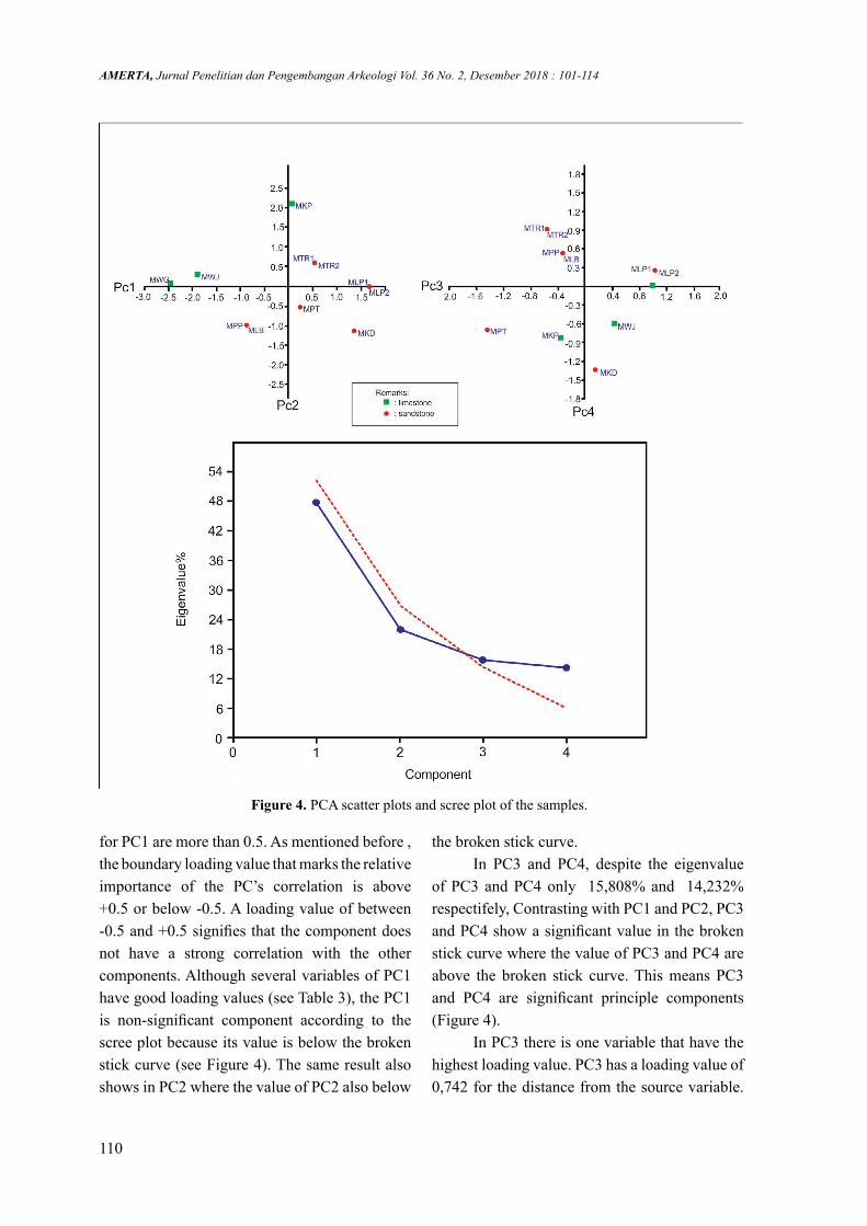
The four variables taken from the 11 megalithic tombs were normalised (see Table 2) and entered into a PCA to identify which may be significant. The percentage eigenvalues that are considered to be representative are those with a cumulative value of up to 95%.
The result from four variables then normalized first before entered to the Principle Component Analysis (PCA). The scater plot, eigenvalue, loading value and scree ploot are the results of PCA. The purpose of PCA is to reduce the variables in a group into several variables which are considered to have the most influence on all of the variables.
The results of the PCA (Table 3) show that if we choose three Principle Component (PC) the percentage eigenvalues is still below 95%, due
No Principle Component
Eigenvalue % variance
1. PC 1 1,9131 47,8282. PC 2 0,885289 22,1323. PC 3 0,632334 15,8084. PC 4 0,569272 14,232
No Variables PC 1 PC2 PC 3 PC 41. Distance
from the source
0,525 -0,29 0,742 -0,3
2. Litology 0,477 -0,61 -0,36 0,5263. Texture 0,543 0,226 -0,54 -0,64. Level of
hardeness0,449 0,706 0,168 0,52
to that we need all Principle Component in our discussion. The variation in the data and all PCs becomes the main focus in this PCA.
3.2 Discussion Knowledge of megalithic tradition
and culture, especially megalithic tombs, is predominantly based on archeological and anthropological approaches (e.g. Das, Subhasis 2015, 2). Only limited studies have been undertaken on raw materials used for building megalithic tombs (Kostov, Ruslan I. 2008, 163; Pearson, Mike Parker 2015, 1332).
In our study, we examine the megalithic tombs from the East Sumba to determine if it is possible to distinguish preference in raw materials based on a geological approach and using Principle Component Analysis (PCA).
3.2.1 PCA
The principal components interpretation is based on the data of which variables are most strongly correlated with each PC. The most strongly influencing variable is the farthest from zero in either positive or negative direction (+/-). Which numbers are considered to be large or small is a subjective decision. The loading value that is traditionally chosen as an indicator of importance is 0.5 (+/-) (Stat 505 2016). If the value of the loading is more than 0.5 (+/-) this indicates that the variable is important and has an influence in separating and clustering the samples within the PCA scatter plot.
The significance level of a Principle Component (PC) can be seen in the scree plot curve. The components may be regarded as insignificant after this curve starts to flatten out, furthermore the eigenvalues may indicate non-significance if they plot below the broken stick curve (Jackson 1993). The scree plot (Figure 4) shows that only PC3 and PC4 are significant, because it has a value above the broken stick (dashed red line). The eigenvalue of PC1 and PC2 are below the broken stick. Therefore, PC1 and PC2 is considered non-significant (see Figure 4). The next step was to analyze the PCs further by examining their loading values for each variable.
The PCA shows that several the loadings
Table 2. PCA eigenvalues summary
Table 3. PCA loading values
110
AMERTA, Jurnal Penelitian dan Pengembangan Arkeologi Vol. 36 No. 2, Desember 2018 : 101-114
Figure 4. PCA scatter plots and scree plot of the samples.
for PC1 are more than 0.5. As mentioned before , the boundary loading value that marks the relative importance of the PC’s correlation is above +0.5 or below -0.5. A loading value of between -0.5 and +0.5 signifies that the component does not have a strong correlation with the other components. Although several variables of PC1 have good loading values (see Table 3), the PC1 is non-significant component according to the scree plot because its value is below the broken stick curve (see Figure 4). The same result also shows in PC2 where the value of PC2 also below
the broken stick curve. In PC3 and PC4, despite the eigenvalue
of PC3 and PC4 only 15,808% and 14,232% respectifely, Contrasting with PC1 and PC2, PC3 and PC4 show a significant value in the broken stick curve where the value of PC3 and PC4 are above the broken stick curve. This means PC3 and PC4 are significant principle components (Figure 4).
In PC3 there is one variable that have the highest loading value. PC3 has a loading value of 0,742 for the distance from the source variable.

Geological Approach in order to Distinguish the Preference Source of the Raw Material From the Megalithic Tombs in East Sumba, Indonesia. Unggul P. Wibowo, Retno Handini, Truman Simanjuntak, Harry O. Sofian, dan Sandy Maulana
111
This means the distance from the source variable has a strong correlation with each component in PC3. Out of PC3, its only in PC1 that indicated also has a strong correlation.
The interesting loading value is shows by the texture variable. Its have high value either in PC3 or PC4, furthermore its also reach a high value in PC1. This means the texture variable has a strong correlation with almost all components in PC1, PC3 and PC4 compare to the other variables that only have a good value in two PCs e.g. the distance from the source variable.
The PCA analysis from the samples show that the texture variable is the most important variable compare to the other variable. After that then the distance from the source variable is regarding the other consideration for getting the megalithic tomb raw material.
3.2.2 Geological AnalysesMostly all of the megalithic tombs come
from low altitude/elevation, except for two (MTR1 and MTR2). This could be because land in lower elevations is usually flat and fertile, attracting human habitation.
Eleven megalithic tombs from several locations were included in the analysis. Among these specimens, there were seven megalithic tombs built from sandstone, with the rest built from limestone.
In the first variable studied, which is the distance from the source assessment, only three megalithic tombs were considered its raw materials were not from near area (MKD, MLP1 and MLP2) (see Table 1). Megalithic tomb material of MKD, MLP1 and MLP2 are sandstone but we found that its erected above limestone rock formation. Based on this condition we argue that the raw material must be taken and transported from another area that have sandstone litology.
The second variable is the litology. There are only to types of litology, the limestone litology and the sandstone litology. The limestone
megalithic tombs were found in MWG, MKP and MWJ. All these megalithic tombs location also represent the hamlet location which is all near the coastline except MWG that located at the limestone hill on Sasar Cape.
The next variable is the texture. Based on the result of the observation on the megalithic tombs samples, it’s look like that the laminary litology is preferer even coarse laminary litology. Only mechanical sedimentation processes that cen be form a laminary structure sediment like fine or coarse lamination. In our megalithic tomb samples only KWG that built from the masif texture rock in this case from coral reef limestone. The characteristic of laminary stone is easy to break by its sedimentation surface, so it’s easy for cutting and making slabs from this kind of stone. The megalithic tomb of MWG is the exceptation. The choosing of masif limestone raw material for megalihic tomb might be based on the effort and distance consideration. As discussed previously, the MWG megalithic tomb is located on the hill at the 321 m above sea level. It will be need a huge cost and effort to bring the raw material from another area, so based on this condition it looks like the Wunga Village (MWG) people choose the stone which availabe from their surounding area, in this case is the masif coral reef limestone.
The last variable is the level of hardness. From eleven megalithic samples, there are six megalithic tombs that its stone have hard charactistic and the other five have medium hard characteristic. Based on these data it looks like that the hard stone is preferer. The raw material enduro should be the reason of this condition.
4. ConclusionArchaelogy study in the East Sumba
Island has been along time have attention for researchers (Truman 2012, 79). Megalithic culture is one of many archeological aspects from East Sumba which attract researchers. Megalitihic culture in Sumba has been extensicely

112
AMERTA, Jurnal Penelitian dan Pengembangan Arkeologi Vol. 36 No. 2, Desember 2018 : 101-114
studied, resulting in many scientific publications on the anthropological and their archological setting. Our study barely scratches the surface of information related to material of megalithic tomb from the East Sumba. This study indicates that the raw material texture are the main preference for making megalithic tombs. The distance from the source and the hardeness of the stone also another important reason for mining the raw material of megalithic tombs no matter what type of its stone. In geological perspective the raw materials of megalithic tombs in East Sumba are taken from the limestone of Kaliangga Formation and the sandstone of Kananggar Formation.
AcknowledgementWe gratefully acknowledge the National
of Archaeological Research Center of Indonesia for providing funding and facilities in this research. We would like to express our deep appreciation to late Mr. Bagyo Prasetyo for sharing his knowledge about Megalithic study during the writing of this paper. Many thanks are also forwarded to our colleagues and all Redactional Boards of Journal Amerta.
BibliographyAbdullah, C.I., Rampnoux, J.P., Bellon, H.,
Maury, R.C., Soeria-Atmadja, R. 2000. “The evolution of Sumba Island (Indonesia) revisited in the light of new data on the geochronology and geochemistry of the magmatic rocks.” Journal of Asian Earth Sciences 18: 533- 546.
Authemayou, Christine; Brocard, Gilles; Delcaillau, Bernard; Molliex, Stephane; Pedoja, Kevin; Husson, Laurent; Aribowo, Sonny; Cahyarini, Sri Yudawati. 2018. Unraveling the Roles of Asymetric Uplift, Normal Faulting and Groundwater Flow to Drainage Rearrangement in an Emerging Karstic Landscape. Earth
Surface Processes and Landforms. John Wiley & Sons, Ltd. Hal 1-14. DOI: 10.1002/esp.4363.
Bonnan, M. 2004. “Morphometric Analysis of Humerus and Femur Shape in Morrison Sauropods: Implications for Functional Morphology and Paleobiology.” Paleobiology 30: 444-470.
Das, Subhasis. 2015. “The Hargarhis of Jharkhand: a Brief Study of the Megaliths of Jharkand.” Chitrolekha International Magazine on Art and Design 5 (1): 2-21.
Effendi, A. C. and Apandi, T. 1993. Peta Geologi Lembar Waikabubak dan Waingapu, Nusatenggara. Bandung: Pusat Penelitian dan Pengembangan Geologi, Badan Geologi.
Martinsson-Wallin, Helene and Wallin, Paul. 2010. “The Story of the Only Megalith Grave on Gotland Island.” Documenta Praehistorica XXXVII: 77-84. DOI: 10.4312\dp.37.7
Nurrochsyam, Mikka Wilda. 2012. “Humanisme dalam Tradisi Kubur Batu Megalitik di Sumba, Nusa Tenggara Timur. Kalpataru.” Majalah Arkeologi 21 (1): 9-19.
Geria, I Made. 2014. “Kearifan Ekologis Kampung Megalitik Rindi Praiyawang, Sumba Timur.” Forum Arkeologi 27 (2): 99-108.
Gordon, S. 2006. The Normal Distribution. Sydney: Mathematics Learning Centre, University of Sydney: 1-41.
Hadiwisastra, Sapri. 1986. “Penelitian Endapan Undak Pantai dan Undak Sungai di Daerah Sumba”. Laporan Penelitian. Bandung: Lembaga Geologi dan Pertambangan Nasional-Lembaga Ilmu Pengetahuan Indonesia. Unpublish work.
Handini, Retno. 2009. “Pulling Stone Ceremony during Megalithic Stone Grave Construction in West Sumba.” Sharing

Geological Approach in order to Distinguish the Preference Source of the Raw Material From the Megalithic Tombs in East Sumba, Indonesia. Unggul P. Wibowo, Retno Handini, Truman Simanjuntak, Harry O. Sofian, dan Sandy Maulana
113
Our Archaeological Heritage Johor Baru, Malaysia, Yayasan Warisan Johor: 182-193.
Handini, Retno. 2012. “Memasyarakatkan” Living Megalithic: Pesona Masa Lalu yang Tetap Bergema.” Kalpataru, Majalah Arkeologi 21 (1): 1-8.
Hammer, Harper, DAT and Ryan, PD. 2001. “Past: Paleontological Statistics Software Package for Education and Data Analysis.” Palaeontologia Electronica 4: 1-9.
Hobgen, Sarah Elizabeth. 2015. Understanding Sediment Sources to Inform Catchment Management in Data-Poor Regions. An Example from Sumba, Eastern Indonesia. Dissertasion. Melbourne: Research Institute for Environment and Livelihoods Faculty of Engineering, Health, Science and Education Charles Darwin University.
Jackson, DA. 1993. “Stopping Rules in Principal Components Analysis: a Comparison of Heuristical and Statistical Approaches.” Ecology 74: 2204-2214.
Kostov, Ruslan I. 2008. Geological and Mineralogical Background of the Megalithic and Rock-Cut Sites in Bulgaria and Some Other European Countries. Proceedings of the International Conference, 29-30 October 2008 Sofia, Publishing House “St. Ivan Rilski”, Sofia: 163-168.
Lansing, J. Stephen; Cox, Murray P.; Downey, Sean S.; Gabler, Brandon M.; Hallmark, Brian; Karafet, Tatiana M.; Norquest, Peter; Schoenfelder, John W.; Sudoyo, H.; Watkins, Joseph C.; and Hammer, Michael F. 2007. “Coevolution of Languages and Genes on the Island of Sumba, Eastern Indonesia.” PNAS 104 (41): 16022-16026.
Lunt, P. 2003. “Biogeography of some Eocene larger foraminifera, and their application in distinguishing geological plates.” Palaeontologia Electronica 6 (1): http://
palaeoelectronica.org/paleo/2003_2/geo/issue2_ 03.htm
Njurumana, Gerson ND. 2008. “Kajian Degradasi Lahan pada Daerah Aliran Sungai Kambaniru, Kanupaten Sumba Timur.” Info Hutan V (3): 241-254.
Pearson, Mike Parker; Bevins, Richard; Ixer, Rob; Pollard, Joshua; Richards, Colin; Welham, Kate; Chan, Ben ; Edinborough, Kevan; Hamilton, Derek; Macphail, Richard; Schlee, Duncan; Schwenninger, Jean-Luc; Simmons, Ellen and Smith, Martin. 2015. “Craig Rhos-y-felin: a Welsh bluestone megalith quarry for Stonehenge.” Antiquity 89: 1331-1352. doi:10.15184/aqy.2015.177
Qian, G, Gabor, G and Gupta, R. 1994. “Principal Components Selection by the Criterion of The Minimum Mean Difference of Complexity.” J. Multiv. Anal. 49: 55-75.
Pirazzoli, P. A., Radtke, U., Hantoro, W. S., Jouannic, C., Hoang, C. T., Causse, C. and Borel Best, M. 1993. “A one million-year-long sequence of marine terraces on Sumba Island, Indonesia.” Marine Geology 109: 221-236.
Prasetyo, Bagyo. 2013. “Persebaran dan Bentuk-Bentuk Megalitik Indonesia: Sebuah Pendekatan Kawasan.” Kalpataru, Majalah Arkeologi 22 (2): 61-122.
Rutherford, E., Burke, K., and Lytwyn, J. 2001. “Tectonic history of Sumba island, Indonesia, since the Late Cretaceous and its rapid escape into the forearc in the Miocene.” Journal of Asian Earth Sciences 19 (4): 453-479.
Rigg, James W. D. and Hall, Robert. 2010. “Structural and Stratigraphic Evolution of the Savu Basin, Indonesia, in Hall, R., Cottam, M.A. and Wilson, M.E.J., eds., The SE Asian Gateway: History and Tectonics of Australia-Asia Collision.” Geological Society of London Special

114
AMERTA, Jurnal Penelitian dan Pengembangan Arkeologi Vol. 36 No. 2, Desember 2018 : 101-114
Publication: 225-240.Satyana, Awang Harun and Purwaningsih,
Margaretha E.M. 2011a. Sumba Area: Detached Sumbaland Terrane and Petroleum Implications. Proceedings JCM Makassar. The 36th HAGI and 40th IAGI Annual Convention and Exhibition: 1-32.
_____. 2011b. Multidisciplinary Approaches on the Origin of Sumba Terrane: Regional Geology, Hystorical Biogeography, Linguistic-Genetic Coevolution and Megalithic Archaeology. Proceedings JCM Makassar. The 36th HAGI and 40th IAGI Annual Convention and Exhibition: 1-29.
Simanjuntak, Truman; Moh Ruly Fauzy;
Galipaud, J.C.; Fadhila A. Aziz; Hallie Buckley. 2012. “Prasejarah Austronesia di Nusa Tenggara Timur: Sebuah Pandangan Awal.” Amerta, Jurnal Penelitian dan Pengembangan Arkeologi 30 (2): 75-89.
Soeria-Atmadja, R., Suparka, S., Abdullah, C.I., Noeradi, D., Sutanto. 1998. “Magmatism in western Indonesia, the trapping of the Sumba block and the gateways to the east of Sundaland.” Journal of Asian Earth Sciences 16(1): 1-12.
Stat 505. 2016. Interpretation of the principal components. Pennstate EberlyCollege of Science.Available from:
https://onlinecourses.science.psu.edu/stat505/node/54. [10 January 2016].