Embed Size (px)
Citation preview
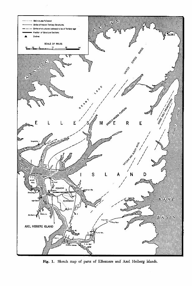
Fig. 1. Sketch map of parts of Ellesmere and Axel Heiberg islands.
I
GEOLOGICAL INVESTIGATIONS IN ELLESMERE AND AXEL HEIBERG ISLANDS, 1956*
R. Thorsteinsson and E. T. Tozert
D URING the past six years members of the Geological Survey of Canada have been investigating the geology of the Queen Eiizabeth Islands.
Parties have worked from the weather stations at Resolute (Thorsteinsson and Fortier, 1954; Thorsteinsson, 19-55>, Isachsen (Heywood, 1954), Alert (Black- adar, 1954) and Mould Bay (Tozer, 1956). R. L. Christie (1955) represented the Survey on the 1954 Northern Ellesmere Expedition of the Defence Research Board (Hattersley-Smith et al., 1955). In 1955, with the aid of helicopters, the members of “Operation Franklin”, a Geological Survey project directed by Y. 0. Fortier, studied the geology of many parts of the country too far from the weather stations to be readily accessible. At the beginning of 1956, the surroundings of only one weather station in the islands, Eureka on the west coast of Ellesmere Island, had not been systematically explored by the Geo- logical Survey. From the studies of Per Schei (in Sverdrup, 1904) and J. C. Troelsen (1950, 1952) it was known to be an area of considerable interest, and this conclusion was confirmed by an examination of air photographs. Conse- quently, the writers undertook an exploration of this area for the Geological Survey between April and September 1956.
The use of the Eureka Weather Station as a base was made possible through courtesy of the Meteorological Division, Air Services, Department of Transport. We wish to express our gratitude to the Director of the Divi- sion, Dr. Andrew Thompson, and also to the Canadian and United States personnel at Eureka for their hospitality and assistance. Transportation to and from Eureka was provided by the R.C.A.F., to whom we are indebted. W e are also grateful to the Commanding Officer of the Thule Air Base, Colonel Frank W. Ellis, U.S.A.F., and Major Claude P. Spence, U.S.A.F., for their generous assistance.
In ‘the course of our field work we travelled by dog team, on foot, and by powered canoe. A full technical report of the work will be published by the Geological Survey of Canada. The present account describes our various journeys and summarizes briefly the geological results of our field work, which have led to a modification of the earlier interpretation of the age and extent of the mountain folding in west central Ellesmere Island. These problems have engaged the interest of many geologists since Per Schei, of
*Published by permission of the Deputy Minister, Department of Mines and Technical Surveys, Ottawa.
?Geologists, Geological Survey of Canada.
5
4 GEOLOGICAL INVESTIGATIONS IN ELLESMERE AND AXEL HEIBERG
the Second Norwegian Polar Expedition in the “Fram”, first described folded Mesozoic rocks in Eureka Sound. They are not entirely unfamiliar to readers of this journal, in which Troelsen (1952) described the results of his recent investigations in Ellesmere Island.
Field work
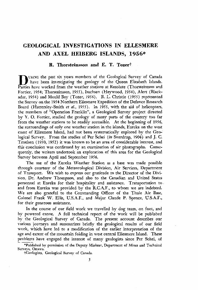
The main routes followed in the course of our field work are shown in Fig. 1. Thorsteinsson arrived at Eureka on April 23 with our first load of equipment and supplies; Tozer followed on April 26 with two Eskimo dog drivers, Amagualik and Jebbedi, engaged at Resolute Bay, 2 0 dogs, and the rest of the equipment.
W e expected that there would be three phases to our field work. For the first we planned to use dog teams as far into the summer as possible; then to travel on foot, extending our range by using caches deposited in the sledging season; and finally, after break-up of the sea ice, to operate from a canoe.
Our sledging started with two trips to the “Sawtooth Range”” to lay out food caches for summer travel on Fosheim Peninsula.
On April 28, Tozer, with Amagualik, left for the lake situated in the prominent wind gap of the “Sawtooth Range”, 48 miles southeast of Eureka. From the head of Slidre Fiord the route lay overland. Travelling conditions were poor and it took three days to get to the upper reaches of a watercourse some eight miles from the lake. From a camp left at this stream the party ascended a narrow ravine with a lightly loaded sledge and so reached the plateau adjacent to the “Sawtooth Range” and the lake. According to the only published map showing this lake (t,he U.S.A.F. chart) it drains west into Eureka Sound. Actually the outlet runs east, then south and eventually into Vesle Fiord. Approaching from Eureka Sound it was therefore necessary to cross the watershed of the “Sawtooth Range” in order to reach the lake, which was covered with rough old ice, clearly more than one year old. Cache 1 was left at the east end of it and here a fine view of the head of Wolf Valley and of the ice-capped mountains beyond was enjoyed.
In returning to Eureka the large river that flows into Eureka Sound opposite Depot Point was followed and from its mouth the party travelled up the sound to Slidre Fiord. Cache 2 was left in the river valley about nine miles inland. Bad weather hampered our field work in July and neither of these caches was actually used. The sea ice on the east side of Eureka Sound between the mouth of the river and Blue Man Cape had been subjected to much pressure and was very rough. Fortunately, it was possible to avoid this bad stretch. Excellent travelling was found on the low shore. Here iced runners that had been of little use farther inland, owing to the many rocks, were a great help. At Blue Man Cape the party took to the ice of the sound. The 50 miles from the river’s mouth ‘to Eureka were covered in about 11 hours on May 3.
Board on Geographical Names. ‘Names that appear in quotation marks have not yet been adopted by the Canadian
GEOLOGICAL INVESTIGATIONS IN ELLESMERE AND AXEL HEIBERG 5
Meanwhile, Thorsteinsson and Jebbedi had left Eureka on April 29 on the other cache-laying journey. From the head of Slidre Fiord they followed Slidre River for about 12 miles. The river was then abandoned for a direct easterly route over the dissected plain that lies west of the “Sawtooth Range”. Foggy weather lasting from the evening of April 29 until May 1 made it impossible to follow it as planned. When the fog lifted it was found that the party had entered the foothills of the “Sawtooth Range” some 8 miles south of the valley where the main cache was to be laid. It was therefore necessary to sledge north along the mountain front to the stream that runs through a prominent wind gap in the range, 8 miles southwest of Cape With, where cache 3 was left. From this valley an attempt was made to cross the mountains to Wolf Valley, but the sledge was becoming so badly damaged by the rocks projecting through the snow that this plan had to be abandoned. Wolf Valley was discovered in 1901 by Fosheim and Raanes, of the ‘LFram’’ Expedition, in the course of their exploration of Canyon Fiord. From Canyon Fiord they travelled up the valley hoping that it might lead to a short cut back to Eureka Sound, and so speed their return journey to the ship. However, they found their way blocked by the mountains now known as the V3awtooth Range”. A sledge route may exist up a branch of Wolf Valley and then along the lake visited by Tozer.
After depositing cache 3, Thorsteinsson travelled down the river that reaches Canyon Fiord west of Cape With. The fiord ice was smooth and covered with hard snow and these conditions provided a welcome change from the poor sledging encountered on the land. The travelling in Greely Fiord was made disagreeable by high sastrugi, much hummocked ice, and a persistent northwest wind, but improved ice conditions and shelter from the wind were found in Eureka Sound. On May 4 the party was back at the weather station.
Both parties found sledging on the plains of Fosheim Peninsula very poor owing to the ubiquitous boulders of morainal origin. These boulders, and the thin snow cover, made it difficult to find a route for the sledges. W e had the same experience as Troelsen, although our difficulties were not comparable with his, for we had dogs to draw our sledges whereas he was pulling his pulka himself (Troelsen, 1952). Thorsteinsson used a large komatik shod with fabric-bound bakelite, made for the Geological Survey in 19.54 by the engineer- ing staff of the National Museum of Canada, under the direction of Mr. J. W. Van Alstine. In ‘the past the bakelite shoeing had proved satisfactory on snow and particularly so on bare sea ice, when sledging late in the season. However, it was quite unsuited to travelling over the bouldery terrain of Fosheim Peninsula and on this one journey of some 120 miles, less than half of which was over land, the shoeing was damaged beyond repair. At Eureka the komatik was shod with steel and gave excellent service afterwards.
After completion of cache-laying we decided to travel together across Greely Fiord and start geological work in Borup Fiord. On May 8 we left Eureka on a good surface, but on the following day, as we neared the north side of Greely Fiord west of Atwood Point, we encountered soft snow. On
6 GEOLOGICAL INVESTIGATIONS IN ELLESMERE AND AXEL HEIBERG
May 10, near rhe mouth of Borup Fiord, the snow became deeper. Borup Fiord had been visited only once before-by A. Elmer Ekblaw of McMillan's Crocker Land Expedition in 191.5. W e had read his account (in McMillan, 1918, Appendix I) and were not entirely unprepared for these conditions. At this stage of the journey we therefore took to the skis that we had brought in anticipation of finding soft snow. During most of the time in the Borup Fiord country we skied, usually ahead of the dogs in order to prepare a trail; without skis we almost invariably sank in the soft undrifted snow to above our knees and often to our waist.
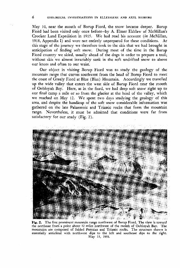
Our object in visiting Borup Fiord was to study the geology of the mountain range that curves southwest from the head of Borup Fiord to mee't the coast of Greely Fiord at Blue (Blaa) Mountain. Accordingly we travelled up the wide valley that enters the west side of Borup Fiord near the mouth of Oobloyah Bay. Here, as in the fiord, we had deep soft snow right up to our final camp a mile or so from the glacier at rhe head of the valley, which we reached on May 12. W e spent two days studying the geology of this area, and despite rhe handicap of the soft snow considerable information was gathered on the late Palaeozoic and Triassic rocks that form the mountain range. Nevertheless, it must be admitted that conditions were far from satisfactory for our study (Fig. 2).
Fig. 2. The first prominent mountain range northwest of Borup Fiord. The view is toward the northeast from a point about 12 miles northwest of the mouth of Oobloyah Bay. The mountains are composed of folded Permian and Triassic rocks. The structure shown is essentially anticlinal with northwest dips to the left and southeast dips to the right.
May 13, 1956.
GEOLOGICAL INVESTIGATIONS IN ELLESMERE AND AXEL HEIBERG 7
With a trail to follow we made better time on the return journey and on May 15 camped just east of Atwood Point. We had spent six days in the Borup Fiord region and the weather during chis period had been exceptionally calm and sunny. Practically all the time while we were there it was so still that one did not need to shield a lighted match. The surface of the snow, both on land and the sea ice was perfectly smooth and quite devoid of wind drift features. Borup Fiord must have an unusually well sheltered situation.
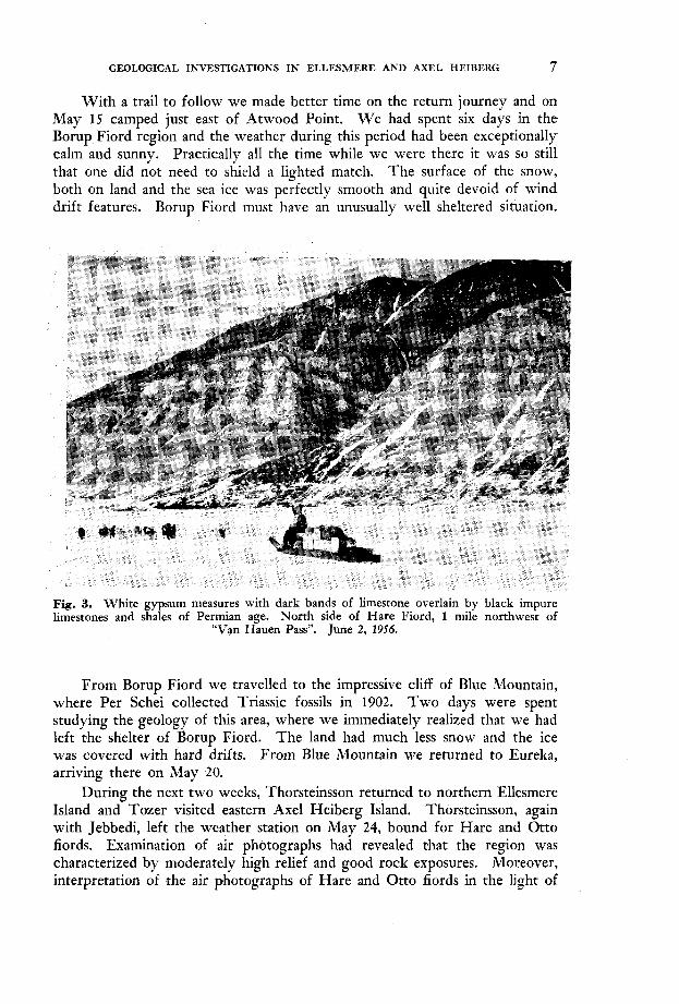
Fig. 3. White gypsum measures with dark bands of limestone overlain by black impure limestones and shales of Permian age. North side of Hare Fiord, 1 mile northwest of
“Van Hauen Pass”. June 2, 1956.
From Borup Fiord we travelled to the impressive cliff of Blue Mountain, where Per Schei collected Triassic fossils in 1902. Two days were spent studying the geology of this area, where we immediately realized that we had left the shelter of Borup Fiord. The land had much less snow and the ice was covered with hard drifts. From Blue Mountain we returned to Eureka, arriving there on May 20.
During the next two weeks, Thorsteinsson returned to northern Ellesmere Island and Tozer visited eastern Axel Heiberg Island. Thorsteinsson, again with Jebbedi, left the weather station on May 24, bound for Hare and Otto fiords. Examination of air photographs had revealed that the region was characterized by moderately high relief and good rock exposures. Moreover, interpretation of the air photographs of Hare and Otto fiords in the light of
8 GEOLOGICAL INVESTIGATIONS IN ELLESMERE AND AXEL HEIBERG
experience gained on the Borup Fiord journey seemed to promise good expo- sures of Upper Palaeozoic rocks. On the Hare Fiord photographs a prominent white formation appears, which resembles an interesting, although relatively poorly exposed unit of gypsum measures that we had found northwest of Borup Fiord. In view of the possible (and later established) relationship of these deposits to those forming piercement structures in Axel Heiberg Island and the Ringnes Islands, a more exact dating than was obtained at Borup Fiord seemed desirable (Fig. 3 ) .
The east coast of Schei Peninsula was followed to Butter Porridge Point, which was reached on May 26. Much of the peninsula was bare of snow except for drifts remaining in the deeper valleys and stream beds. At the point Eskimo tent rings were seen that presumably represent those found by Sverdrup and Schei (Sverdrup, 1904, Vol. II, p. 205) . From the northwestern extremity of Schei Peninsula, Nansen Sound was crossed to reach the peninsula lying between Hare and Otto fiords, the coast of which was followed to the entrance of Hare Fiord. This coast is bounded by nearly vertical cliffs composed mainly of dark grey and black rocks, that rise to a height of about 1,500 feet. On May 28 these cliffs were entirely free of snow; working on them proved pleasantly warm, and meltwater was seen for the first time in the season. These cliffs probably represent the feature named “Black Mountain”
GEOLOGICAL INVESTIGATIONS IN ELLESMERE AND AXEL HEIBERG 9
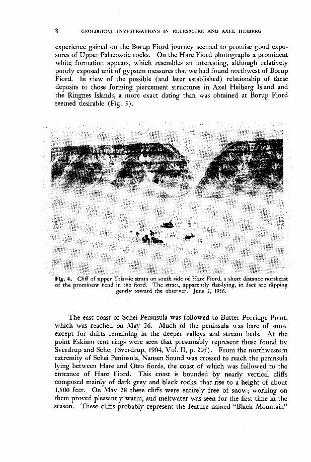
by Sverdrup. Travelling conditions from Slidre Fiord to Hare Fiord were fair. Nansen Sound, and Greely Fiord, in contrast to the shekered fiords to the north, are evidently virtual wind funnels and here the ice was covered with sastrugi and other drift features. A patch of badly hummocked ice about two miles wide and a pressure ridge marked the entrance to Hare Fiord, but inside the fiord the snow and ice conditions were in remarkable contrast to those of the other regions visited. Drift features were rare, the ice was perfectly smooth and the snow seldom deeper than three inches. The surface was almost too slippery for comfortable walking, but there was sufficient snow to give the dogs a foothold. The land surrounding this long fiord was also mostly free of snow (Fig. 4).
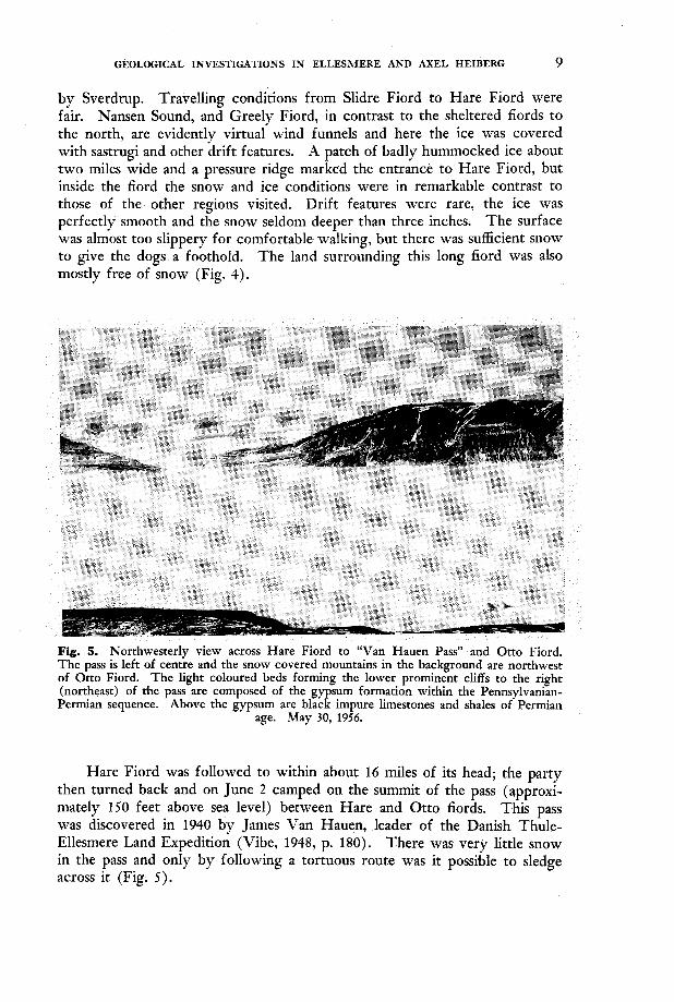
Fig. 5. Northwesterly view across Hare Fiord to “Van Hauen Pass” and Otto Fiord. The pass is left of centre and the snow covered mountains in the background are northwest of Otto Fiord. The light coloured beds forming the lower prominent cliffs to the right (northeast) of the pass are composed of the gypsum formation within the Pennsylvanian- Permian sequence. Above the gypsum are black impure limestones and shales of Permian
age. May 30, 1956.
Hare Fiord was followed to within about 16 miles of its head; the party then turned back and on June 2 camped on the summit of the pass (approxi- mately 150 feet above sea level) between Hare and Otto fiords. This pass was discovered in 1940 by James Van Hauen, leader of the Danish, Thule- Ellesmere Land Expedition (Vibe, 1948, p. 180). There was very little snow in the pass and only by following a tortuous route was it possible to sledge across it (Fig. 5 ) .
10 GEOLOGICAL INVESTIGATIONS IN ELLESMERE AND AXEL HEIBERG
On June 3 the party reached Otto Fiord and proceeded towards Degerbols Island, named by the Van Hauen Expedition. Again a profound change in snow conditions was experienced. Both land and ice were covered with a heavy mantle of snow and outcrops were visible only on the steepest cliff faces. In che first five miles from the pass the depth of snow increased from about five inches to two feet. Twelve miles west of Degerbols Island the snow was up to three feet deep. Here it was decided to return to Eureka by way of Hare Fiord rather than continue down Otto Fiord in deep SROW that made geological work well nigh impossible. On June 7 the party was back a t the weather station having travelled about 250 miles since May 14.
Between May 24 and June 7 Tozer, accompanied by Amagualik, studied the east coast of Axel Heiberg Island between Skraeling Point and Mokka Fiord. During this period five days were spent a t Buchanan Lake” southwest of the head of Mokka Fiord.
Smooth ice provided excellent travelling along most of the coast of Axel Igeiberg Island, but an unusually bad surface was encountered in Mokka Fiord where rhe ice was much hummocked and in many places covered with up to six inches of wind-blown sand, grit and mud. Mokka is Norwegian for muck and the fiord is appropriately named. The narrow neck of land separating 1Llokka Fiord from the lake was practically free of snow except for an occa- sional small snowbank immediately adjacent to ithe river. Old Eskimo tent rings and some structures that Amagualik called fireplaces were found here. The ice on the lake was smooth, almost completely devoid of snow and, like the fiord to the east, locally covered with wind-blown detritus. The surround- ing mountain sides were also virtually snow free. In July 1953 a Canso aircraft landed George Jacobsen and his party on this lake which normally seems to be free of ice in the summer. As suggested by A. C. Fryer of the R.C.M.P. (Arctic Circular, 1954, p. 35) dirt blown on the surface of the lake apparently accelerates the melting.
On June 10, travelling together, we left Eureka on our last sledge journey. W e had originally planned to go straight to Canyon Fiord, but in view of the interesting geological problems to the north we finally decided to do more work near Nansen Sound first. W e travelled straight up to the peninsula between Hare and Otto fiords. It took two days to reach our destination and June 12-18 were spent examining the coast between the two fiords. On June 16 high southeast winds melted practically all the remaining snow on the ice, adjacent to rhe cliffs. On June 19 we crossed Hare Fiord and made our last camp in northern Ellesmere Island on the east side of the fiord. Nearby were seven Eskimo tent rings and numerous musk ox bones encrusted with orange lichen. On June 22 we concluded our field work in northern Ellesmere and returned to Fosheim Peninsula. In Greely Fiord nearly all the snow had melted on the ice and the surface was covered with pools of water up to 3 feet deep. On arrival at Iceberg Point we found a substantial shore lead and this feature was to hinder our work from then on. From Iceberg
*Buchanan Lake is now the official name for this body of water. In the past it has been called “Maersk Lake” (Vibe 1948, p. 180) and “Diana Lake” (Porsild, 1955, p. 3 5 ) .
___
I GEOLOGICAL INVESTIGATIONS IN ELLESMERE AND AXEL HEIBERG 11
Point we travelled to East Cape in Canyon Fiord where we spent two excep- tionally warm and sunny days studying the geology. It was now June 29, the rough ice was very hard on the dog’s feet, and we were not adequately supplied with dog boots. Canyon Fiord was traversed by wide cracks and the shore lead was making it increasingly difficult to get from the ice to the land. The Eskimo were loath to travel any farther up the fiord and we felt that their misgivings were justified. Regretfully we returned to Eureka. This occupied four days of fine weather and early in the morning of July 3 we were back at the weather station. The shore lead made it practically impossiable to study the coast on the way. Between the west shore of Canyon Fiord, a few miles north of Cape With, and Iceberg Point, only one ice bridge (near Mount Lockwood) remained.
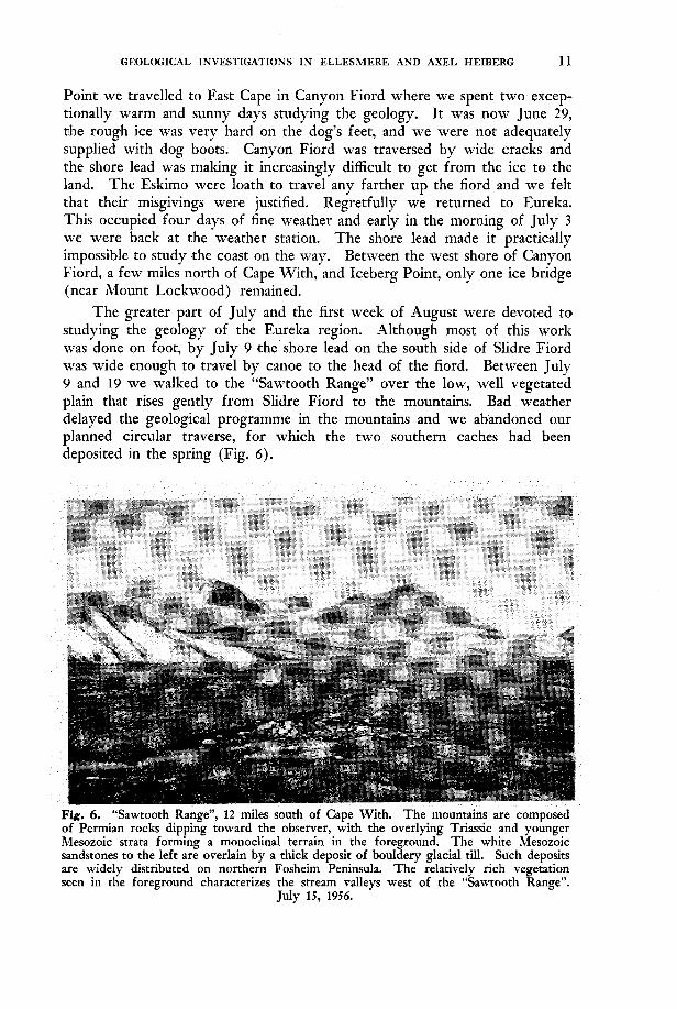
The greater part of July and the first week of August were devoted to studying the geology of the Eureka region. Although most of this work was done on foot, by July 9 the shore lead on the south side of Slidre Fiord was wide enough to travel by canoe to the head of the fiord. Between July Y and 19 we walked to the “Sawtooth Range” over che low, well vegetated plain that rises gently from Slidre Fiord to the mountains. Bad weather delayed the geological programme in the mountains and we abandoned our planned circular traverse, for which the two southern caches had been deposited in the spring (Fig. 6 ) .
sandstones to the left ark overlain by a thick deposit of bodaery glacial till. Such deposits are widely distributed on northern Fosheim Peninsula. The relatively rich vegetation seen in the foreground characterizes the stream valleys west of the “Sawtooth Range”.
July 15, 1956.
12 GEOLOGIC.4L INVESTIGATIONS IN ELLESMERE AND AXEL HEIBERG
On our return from the “Sawtooth Range” on July 19 much of Slidre Fiord was free of ice and we stapted planning the final phase af the field work which involved taking the canoe into Eureka Sound and travelling to the head of either Bay Fiord or Canyon Fiord.
The head of each fiord lies some 1 3 5 miles by water from the weather station and both are regions of considerable geological interest. It was our plan to travel as quickly as possible to the head of one of these fiords and to undertake the greater part of the geological work on the return journey. W e had decided to let the ice conditions govern our choice.
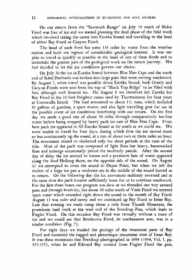
On July 30 the ice in Eureka Sound between Blue Man Cape and the south end of Schei Peninsula was broken into large pans that were moving southward. By August 7, when travel was possible down Eureka Sound, both Greely and Canyon Fiords were seen from the top of “Black Top Ridge” to be filled with fast, although well fissured ice. On -4ugust 8 we therefore left Eureka for Bay Fiord in the 22-foot freighter canoe used by Thorsteinsson for four years at Cornwallis Island. The load amounted to about 1 ‘/z tons, which included 85 gallons of gasoline, a spare motor, and also light travelling gear for use in the possible event of ice conditions interfering with our return. On the first day we made a good run of about 30 miles through comparatively ice-free water before being stopped by heavy pack ice east of Blue Man Cape. From here pack ice appeared to fill Eureka Sound as far south as we could see. W e were unable to travel for four days, during which time the ice moved more o r less continuously up the sound, at a rate of about two or three miles sn hour. The movement ceased or slackened only for short periods a t the turn of the tide. Most o,f the pack was composed of light floes. but heavy, hummocked floes and icebergs occasionally joined the northerly parade. After the second day of delay the ice seemed to loosen and a persistent lane of water appeared along the Axel Heiberg shore, on the opposite side of the sound. On August 11 we attempted to cross the sound to Depot Point, but when we left the shelter o’f a large ice pan a moderate sea in the middle of the sound forced us to return. On the following day the ice movement suddenly reversed and a t the same time the pack became sufficiently loose for us to continue southward. For the first three hours our progress was slow as we threaded our way around pans and through brash ice, but about 30 miles north of Vesle Fiord we entered open water which extended right down the sound to ‘the mouth of Bay Fiord. August 1 3 was calm and sunny and we continued up Bay Fiord to Irene Bay. Late that evening we made camp about a mile from Thumb Mountain, the prominent land mark a t the west end of the Sverdrup Pass, which leads to Flagler Fiord. On this occasion Bay Fiord was virtually without a trace of ice and we could see that Strathcona Fiord, its southeastern arm, was in a similar condition (Fig. 7 ) .
For eight days we studied the geology of the innermost parts of Bay Fiord and examined the rugged and picturesque mountains west of Irene Bay. It was these mountains that Sverdrup photographed in 1899 (1954, Vol. I, pp. lS2-155), when he and Edward Bay crossed from Flagler Fiord the pass,
GEOLOGICAL INVESTIGATIONS IN ELLESMERE AND AXEL HEIBERG 1 3
Fig. 7. Head of Irene Bay. T'he conical hill in the centre is Thumb Mountain. The western entrance to Sverdrup Pass lies immediately to the left of the mountain.
August 21, 1956.
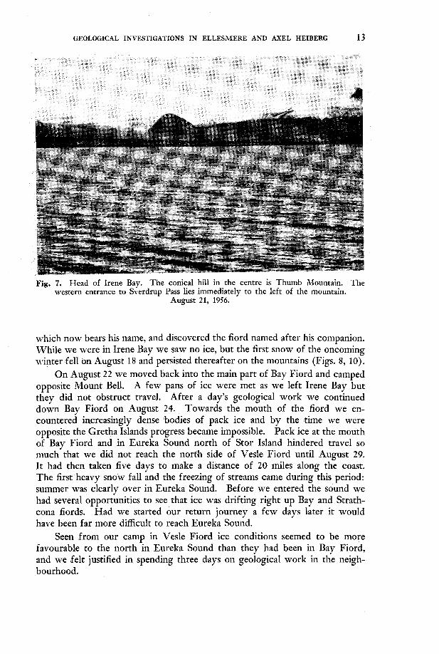
which now bears his name, and discovered the fiord named after his companion. While we were in Irene Bay we saw no ice, but the first snow of the oncoming winter fell on August 18 and persisted thereafter on the mountains (Figs. 8, lo).
On August 2 2 we moved back into the main part of Bay Fiord and camped opposite Mount Bell. A few pans of ice were met as we left Irene Bay but they did not obstruct travel. After a day's geological work we continued down Bay Fiord on August 24. Towards the mouth of rhe fiord we en- countered increasingly dense bodies of pack ice and by the time we were opposite the Gretha Islands progress became impossible. Pack ice at the mouth of Bay Fiord and in Eureka Sound north of Stor Island hindered travel so much that we did not reach the nortmh side of Vesle Fiord until August 29. It had then taken five days to make a distance of 20 miles along the coast. The first heavy snow fall and the freezing of streams came during rhis period: summer was clearly over in Eureka Sound. Before we entered the sound we had several opportunities to see that ice was drifting right up Bay and Strath- cona fiords. Had we started our return journey a few days later it would have been far more difficult to reach Eureka Sound.
Seen from our camp in Vesle Fiord ice conditions seemed to be more favourable to the north in Eureka Sound than they had been in Bay Fiord, and we felt justified in spending three days on geologicaI work in the neigh- bourhood.
14 GEOLOGICAL INVESTIGATIONS IN ELLESMERE AND AXEL HEIBERG
Fig. 8. Looking east toward the Sverdrup Pass. The highest mountain visible on the north side of the valley is Witch Mountain (Hexefjeld). Sverdrup and Bay climbed this mountain in order to find a westward route while exploring the valley in 1899. Facing Witch Mountain may be seen the large glacier that added to their difficulties in finding
a route through the pass (See Sverdrup, Vol. I, pp. 121, 1 3 2 ) . August 14, 1956.
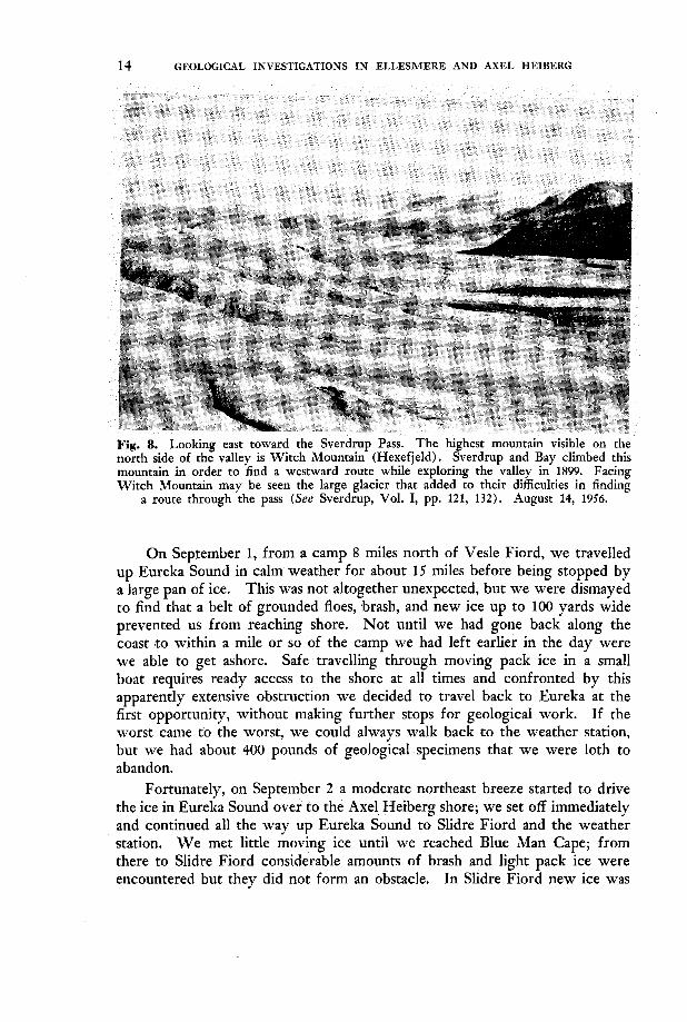
On September 1, from a camp 8 miles north of Vesle Fiord, we travelled up Eureka Sound in calm weather for about 15 miles before being stopped by a large pan of ice. This was not altogether unexpected, but we were dismayed to find that a belt of grounded floes, brash, and new ice up to 100 yards wide prevented us from reaching shore. Not until we had gone back along the coast to within a mile or so of the camp we had left earlier in the day were we able to get ashore. Safe travelling through moving pack ice in a small boat requires ready access to the shore a t all times and confronted by this apparently extensive obstruction we decided to travel back to Eureka at rhe first opportunity, without making further stops for geological work. If the worst came to the worst, we could always walk back to the weather station, but we had about 400 pounds of geological specimens that we were loth to abandon.
Fortunately, on September 2 a moderate norrheast breeze started to drive the ice in Eureka Sound over to the Axel-Heiberg shore; we set off immediately and continued all the way up Eureka Sound to Slidre Fiord and the weather station. W e met little moving ice until we reached Blue Man Cape; ,from there to Slidre Fiord considerable amounts of brash and light pack ice were encountered but they did not form an obstacle. In Slidre Fiord new ice was
GEOLOGICAL INVESTIGATIONS IN ELLESMERE AND AXEL HEIBERG 15
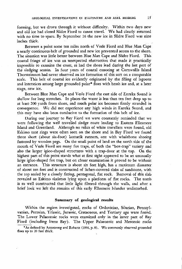
forming, but we drove through it without difficulty. Within two days new and old ice had closed Slidre Fiord to canoe travel. W e had clearly returned with no time to spare. By September 16 $he new ice in Slidre Fiord was nine inches thick.
Between a point some ten miles north of Vede Fiord and Blue Man Cape a nearly continuous belt of grounded and new ice prevented access tom the shore. The situation was little bemr between Blue Man Cape and Slidre Fiord. This coastal fringe of ice was an unexpected obstruction that made it practically impossible to examine the coast, as had the shore lead during the last part of the sledging season. In four years of coastal canoeing at Cornwallis Island Thorsteinsson had never observed an ice formation of this sort on a comparable scale. This belt of coastal ice evidently originated by the filling of lagoons and interstices among large grounded polar* floes with brash ice and, at a later stage, new ice.
Between Blue Man Cape and Vesle Fiord the east side of Eureka Sound is shallow for long stretches. In places the water is less than ten feet deep up to at least' 200 yards from shore, and much polar ice becomes firmly stranded in consequence. W e did not experience any high winds in Eureka Sound, and this may have also been conducive tom the formation of this belt of ice.
During our journey to Bay Fiord we were constantly reminded that we were following the well travelled sledge route leading to Eastern Ellesmere Island and Greenland. Although no relics of white travellers were found, old Eskimo tent rings were often seen on the shore and in Bay Fiord we found three short (about six-foot) komatik runners, one with whalebone shoeing fastened by wooden pegs. Qn the small point of land on the north side of the mouth of Vesle Fiord are many fox traps, of both the "box-trap" variety and also the larger igloo-shaped structures with a trap-door a t the top. On the highest part of this point stands what a t first sight appeared to be an unusually large igloo-shaped fox trap, but on closer examination it proved to be without an entrance. This structure is about six feet high, has a maximum diameter of about ten feet and is constructed of lichen-covered slabs of sandstone, with the top sealed by a closely fitting, penatagonal, flat rock. Removal of this slab revealed an Eskimo skeleton lying upon a platform of flat rocks. The tomb is so well constructed that little light filtered through the walls, and after a brief look we left 'the remains of this early Ellesmere Islander undisturbed.
Summary of geological results
Within the region investigated, rocks of Ordovician, Silurian, Pennsyl- vanian, Permian, Triassic, Jurassic, Cretaceous, and Tertiary age were found. The Lower Palaeozoic rocks were examined only in the inner part of Bay Fiord (including Irene Bay). The Upper Palaeozoic and Mesozoic rocks
*As defined by Armstrong and Roberts (1956, p. 8). We commonly observed grounded floes up to 20 feet rhick.
"
16 GEOLOGICAL INVESTIGATIONS “IN ELLESMERE AND AXEL HEIBERG
were examined on Fosheim Peninsula, southwestern Grant Land and eastern Axel Heiberg Island. The information obtained may be summarized con- veniently by describing, in outline, the geology of two areas: (1) Inner Bay Fiord and Irene Bay, where the Lower Palaeozoic rocks occur; (2) Western Fosheim Peninsula and southwestern Grant Land, an area characterized by Upper Palaeozoic and Mesozoic rocks. These two areas have only one formation in common-the non-marine Eureka Sound group, which according to fossil plants collected by members of “Operation Franklin” is now definitely known to include strata of Tertiary age. Throughout the entire region studied the Eureka Sound beds represent the youngest known formation. The contact between the Lower and Upper Palaeozoic rocks is not known to outcrop within the area studied, but thanks to the recent work of J. C. Troelsen it is known that an angular unconformity separates Lower and Upper Palaeozoic strata in central Canyon Fiord, a short distance east of Fosheim Peninsula. The relationship of the Eureka Sound group to the older formations in the region studied shows that the whole of Fosheim Peninsula and also the country around Bay Fiord, have suffered Tertiary orogenesis. A discussion of this relationship follows the description of the two areas. The geological account closes with a discussion of the possible extent of these Tertiary earth move- ments in other parts of Ellesmere Island.
Our conclusions regarding the structural history of Ellesmere Island differ from those of some of the earlier workers. I t seems appropriate to summarize the conclusions of the pioneers, Per Schei, Robert Bentham and J. C. Troelsen, and also to refer to the relevant contributions by members of “Operation Franklin”, before introducing our own data.
Per Schei, a member of the Second Norwegian “Fram” Expedition, was the first to describe the geology of west central Ellesmere Island. Schei col- lected Triassic fossils from folded rocks in Eureka Sound. He also described “Miocene sand and lignite” a t various localities and he stated that the strati- fication of these “Miocene” rocks was undisturbed. Concerning the structural history of the Eureka Sound area Schei concluded “that the more conspicuous dislocations are post-Triassic, but pre-Miocene” (Schei, in Sverdrup, 1904, Vol. 11, p. 463).
Robert Bentham (1941) made some important observations concerning southern Ellesmere Island, for he suggested that faulting had taken place after the deposition of Schei’s “Miocene” beds. Bentham’s views anticipate our own to a considerable extent.
J. C. Troelsen was the next geologist to make field observations in this area. In 1950 he published a report (Troelsen, 1950) based on his work as geologist of the 1939-1940 Van Hauen Expedition. He showed that gently folded Pennsylvanian and Permian rocks occur in Canyon Fiord, overlain conformably by strata believed to be possibly of Jurassic age (Cape With formation). He also described folded Ordovician and Silurian rocks in the upper part of Bay Fiord. Troelsen concluded that Ellesmere Island has been
GEOLOGICAL INVESTIGATIONS IN ELLESMERE AND AXEL HEIBERG 17
subjected to orogenesis twice since the Precambrian: once in the Palaeozoic, prior to the deposition of the Pennsylvanian rocks and again in the Mesozoic or Cenozoic. Troelsen’s Mesozoic or Cenozoic orogeny is the same as Schei’s post-Triassic, pre-Miocene deformation. Troelsen’s rather more elastic dating of the younger orogeny reflects his conclusion that Schei’s “Miocene” strata (named the Eureka Sound group by Troelsen) could be of Cretaceous or Tertiary age.
In 1952 Troelsen returned to Ellesmere Island and demonstrated con- clusively that a conspicuous angular unconformity separates Silurian and Middle Pennsylvanian rocks a t “Caledonian Bay’’ in Canyon Fiord (Troelsen, 1952). On this occasion he also discovered folded late Jurassic-Early Creta- ceous beds with Aucella, and other fossils, near Eureka weather station. In a MS account submitted to the Arctic Institute of Norrh America in February 1954, Troelsen records fossil identifications by C. W. Wright and J. A. Jeletzky that show his collections to be of early Lower Cretaceous age. Following his field work of 1952, Troelsen’s conclusions regarding the tectonic history of west central Ellesmere Island can be summarized as follows: the earlier orogeny took place in “post-Silurian (or possible late Silurian) but pre-Middle Carboni- ferous” (Middle Pennsylvanian) time; and the younger orogeny, involving Pennsylvanian, Permian, Triassic and Lower Cretaceous rocks, took place before the deposition of the Eureka Sound group.
I t should be mentioned that Schei and Troelsen did not describe an un- conformable contact between the Eureka Sound beds and the folded Mesozoic rocks. Their conclusion that such an unconformity existed was based solely upon rhe apparent absence of folds in the Eureka Sound group comparable with those shown by the Mesozoic rocks.
Two members of “Operation Franklin” obtained additional data on the Eureka Sound beds. N. J. McMillan collected fossil plants on north-western Fosheim Peninsula which have been examined by W. L. Fry of the Geological Survey of Canada. Fry considers that the plants from Fosheim Peninsula are od Tertiary, and probably of early Tertiary (Palaeocene or Eocene) age. A. W. Norris studied the Eureka Sound beds near Vendome Fiord. Both McMillan and Norris noted that the Eureka Sound beds had been folded and concluded, contrary to the opinions of Schei and Troelsen, that the Eureka Sound group does not constitute a simple post-orogenic formation. Unfor- tunately, the base of the Eureka Sound group is not exposed in the areas studied by McMillan and Norris so that the relation to the older folded rocks could not be determined.
Inner Bay Fiord and Irene Fiord
Rocks of Ordovician, Silurian and possibly Devonian age, and also the Eureka Sound group, were studied in Irene Bay and in inner Bay Fiord. After examining the maps prepared by Schei and Troelsen we had expected to find
18 GEOLOGICAL INVESTIGATIONS IN ELLESMERE AND AXEL HEIBERG
Precambrian rocks exposed in this region and perhaps also the basal Palaeozoic strata. The shores of Irene Bay, however, are composed entirely of Palaeozoic and Eureka Sound rocks.
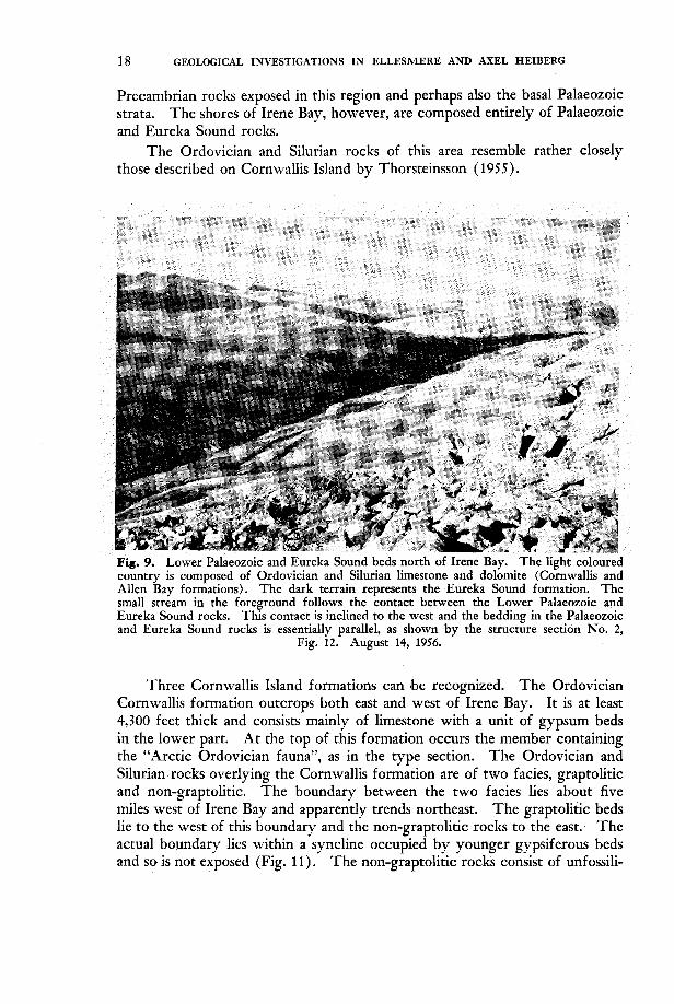
The Ordovician and Silurian rocks of this area resemble rather closely those described on Cornwallis Island by Thorsteinsson (1955).
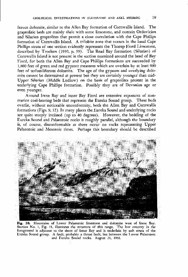
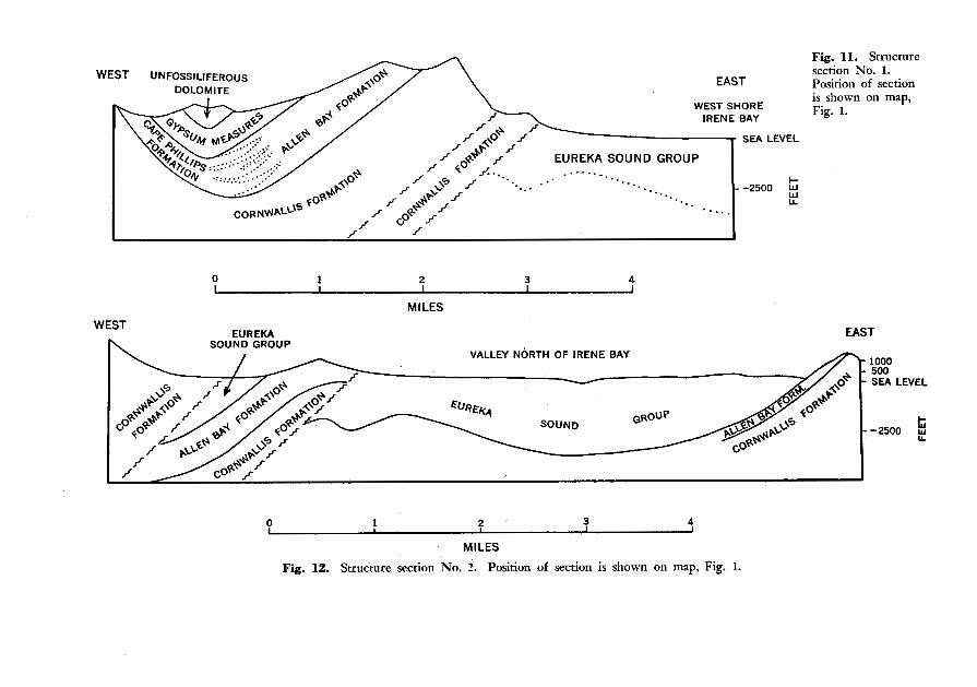
Three Cornwallis Island formations can ‘be recognized. The Ordovician Cornwallis formation outcrops both east and west of Irene Bay. It is at least 4,300 feet thick and consists mainly of limestone with a unit of gypsum beds in the lower part. At the top of this formation occurs the member containing the “Arctic Ordovician fauna”, as in the type section. The Ordovician and Silurian rocks overlying the Cornwallis formation are of two facies, graptolitic and non-graptolitic. The boundary between the two facies lies about five miles west of Irene Bay and apparently trends northeast. The graptolitic beds lie to the west of this boundary and the non-graptolitic rocks to the east. The actual boundary lies within a syncline occupied by younger gypsiferous beds and so is not exposed (Fig. 11). The non-graptolitic rocks consist of unfossili-
GEOLOGICAL INVESTIGATIONS IN ELLESMERE AND AXEL HEIBERG 19
ferous dolomite, similar to the Allen Bay formation of Cornwallis Island. The graptolitic beds are mainly shale with some limestone, and contain Ordovician and Silurian graptolites that permit a close correlation with the Cape Phillips formation of Cornwallis Island. A trilobite zone that occurs in the basal Cape Phillips strata of one section evidently represents the Thorup Fiord Limestone, described by Troelsen (1950, p. 59). The Read Bay formation (Silurian) of Cornwallis Island is not present in the section examined around the head of Bay Fiord, for both the Allen Bay and Cape Phillips formations are succeeded by 1,800 feet of green and red gypsum measures which are overlain by at least 900 feet of unfossiliferous dolomite. The age of the gypsum and overlying dolo- mite cannot be determined at present but they are certainly younger than mid- Upper Silurian (Middle Ludlow) on the basis of graptolites present in the
even younger. Around Irene Bay and inner Bay Fiord are extensive exposures of non-
marine coal-bearing beds that represent the Eureka Sound group. These beds overlie, without noticeable unconformity, both the Allen Bay and Cornwallis formations (Figs. 9, 12) . In many places the Eureka Sound and underlying rocks are quite steeply inclined (up to 40 degrees). However, the bedding of the Eureka Sound and Palaeozoic rocks is roughly parallel, although the boundary is, of course, disconformable as there occur no rocks representing Upper Palaeozoic and Mesozoic times. Perhaps this boundary should be described
I underlying Cape Phillips formation. Possibly they are of Devonian age or
Fig. 10. Mountains of Lower Palaeozoic limestone and dolomite west of Irene Bay. Section No. 1, Fig. 11, illustrates the structure of this range. T,he low country in the foreground is adjacent to the shore of Irene Bay and is underlain by soft strata of the Eureka Sound group. A fault, probably a thrust fault, lies between the Lower Palaeozoic
and Eureka Sound rocks. August 21, 1956.
20 GEOLOGICAL INVESTIGATIONS IN ELLESMERE AND AXEL HEIBERG
as a mild angular unconformity, for as shown in Fig. 12, the thickness of Allen Bay strata beneath the Eureka Sound beds is greater on the west side of Irene Bay than on the east. Furthermore, formations younger than the Allen Bay formation appear a short distance west of Irene Bay (Fig. 11). In rhe Irene Bay area the Eureka Sound beds were presumably deposited upon a terrain dipping gently to the west and formed by the Allen Bay and younger forma- tions.
The Lower Palaeozoic rocks, together with the essentially conformable overlying layer of Eureka Sound beds have been folded and faulted. The strike of both folds and faults is about northeast. iMost of the faults that dislocate the strata have upthrow sides to the west and they are believed to represent thrust faults (Figs. 11, 12) . This faulting is very prominently expressed in the topography of inner Bay Fiord and Irene Bay, for the Lower Palaeozoic rocks form mountainous ridges and the synclines and downfaulted areas of Eureka Sound rocks form the wide valleys and rolling hills. The contrasting geology is conspicuously reflected in the nature of the vegetation (Figs. 9, IO). The lowlands formed by the Eureka Sound rocks are exceptionally well vegetated; the Palaeozoic limestone and dolomite areas, as in so many parts of the Arctic Archipelago, are almost, to quite barren.
The discovery that the Palaeozoic and Eureka Sound beds are folded together at the head of Bay Fiord places the age of deformation in the Tertiary period. This result was quite unexpected, for Troelsen (1950, p. 2 s ) believed that the inclined attitude of the Lower Palaeozoic rocks in this area was due to Palaeozoic earth movements.
Western Fosheim Peninsula and southwestern Grant Land
Field work on Fosheim Peninsula, west of the “Sawtooth Range” and in southwestern Grant Land has revealed a structurally conformable sequence of Pennsylvanian, Permian, Triassic, Jurassic, Lower Cretaceous, Upper Cretaceous and Tertiary rocks. The Tertiary rocks belong in the Eureka Sound group. The sequence recognized in southwestern Grant Land ranges from Pennsylvanian to Triassic and that of Fosheim Peninsula from Permian to Tertiary. The “Miocene” rocks described by Schei (in Nathorst, 1915, p. 7) in Grant Land (west of Blue (Blaa) Mountain) are placed in the Triassic by the writers. Gabbro sills occur in the Pennsylvanian, Permian and Triassic formations, and they are thickest and most abundant in the Triassic. This whole sequence has been folded, in places quite severely. South of Greely Fiord fold axes generally trend northerly. North of Greely Fiord they commonly trend northeasterly. Much faulting is associated with this defor- mation. Most of the faults parallel anticlinal axes, and most (but not all) have rheir upthrow side to the west or northwest. It therefore seems probable that they, like the structures in Irene Bay, represent thrust faults.
The Pennsylvanian and Permian rocks include limestone, shale, chert, and sandstone. The facies relationships are apparently complex and cannot be
WEST UNFOSSILIFEROUS EAST
WEST SHORE IRENE BAY
SEA LEVEL
EUREKA SOUND GROUP ...... -. -. ... -. - -2500 2 .... .. LL ....
L
0 1 2 3 4
Fig. 11. Structure section No. 1. Position of section is shown on map, Fig. 1.
MILES WEST
n EUREKA SOUND GROUP
I
- " VALLEY NORTH OF IRENE BAY
0 I 3 ' 3 4
MILES
Fig. 12. Structure section No. 2. Position of section is shown on map, Fig. 1.
1000 500 SEA LEVEL
22 GEOLOGICAL INVESTIGATIONS IN ELLESMERE AND AXEL HEIBERG
adequately treated here. Of particular interest is a unit of gypsum with some interbedded limestone, in all about 700 feet thick, which occurs within the Pennsylvanian-Permian sequence in the upper reaches of Hare Fiord and on the peninsula between Borup and Hare fiords, Northeast of the entrance to Hare Fiord the bedded gypsum, when traced along strike, develops into an intrusive piercement body, in which the gypsum has been forced upward to come into contact with rocks that normally are separated from it in the strati- graphic section. At Fair Cape, on the east coast of Axel Heiberg Island, contorted strata of gypsum and limestone, closely resem’bling the gypsum measures of Hare and Borup fiords, form the core of a piercement anticline. In this structure the gypsum has pierced the overlying sedimentary layers and is in contact with Upper Triassic rocks. It seems reasonable to conclude that this gypsum represents the same formation that has provided the gypsum in the cores of piercement structures in the Ringnes Islands (Heywood, 1954; Fortier et al., 1954) and other parts of the Archipelago.
The Mesozoic rocks of western Fosheim Peninsula and adjacent regions to the north include an aggregate thickness of about 20,000 feet of strata. Sandstones and shales are the most common rocks and both marine and non- marine deposits are present. Relatively coarser detritus is found to the east, in the foothills of the “Sawtooth Range”, and there can be no doubt that the source of most of the Mesozoic sediment lay in that direction.
Marine deposits of Lower, Middle, and Upper Triassic age were found. Troelsen’s Cape With formation (Troelsen, 1950, p. 7 5 ) of the “Sawtooth Range”, formerly of uncertain age, has yielded Triassic ammonites (Nathor- stites). This formation is believed to represent a sandy facies of the finer grained Triassic rocks (Blaa Mountain formation) described by Per Schei and Troelsen farther west in Eureka Sound. The youngest Triassic rocks are mainly sandstones and include non-marine strata with thin coal seams. They are overlain by a sequence of Jurassic rocks of partly marine, but mainly of non-marine origin. Above this Jurassic formation lies the Deer Bay shale, which was originally described on Ellef Ringnes Island by Heywood ( 1954). The lower part of the Deer Bay formation contains Upper Jurassic ammonites; higher beds contain Aucella and ammonites of early lower Cretaceous age. It was from this formation that Troelsen (1952, p. 208) collected Aucella. The succeeding Cretaceous rocks consist of alternating marine and non-marine formations. Above the Deer Bay shale is the non-marine Isachsen formation, composed mainly of sandstones; then the marine Christopher shale of late Lower Cretaceous age; next another non-marine sandstone which is followed by a marine Upper Cretaceous shale with distinctive representatives of the pelecypod genus Znoceramus. The Isachsen and Christopher formations, like the Deer Bay, were originally defined on Ellef Ringnes Island by Heywood. The succeeding non-marine sandstone and the Upper Cretaceous shale have not yet been formally named.
Above the Upper Cretaceous shale there follows, apparently in perfect conformity, a thick sequence of non-marine beds, with several seams of coal
GEOLOGICAL INVESTIGATIONS I N ELLESMERE AND AXEL HEIBERG 23
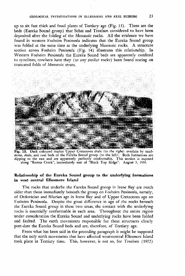
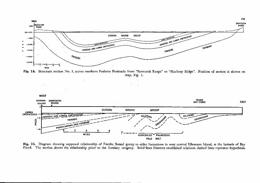
up to six feet thick and fossil plants of Tertiary age (Fig 13). These are the beds (Eureka Sound group) that Schei and Troelsen considered to have been deposited after the folding of the Mesozoic rocks. All the evidence we have found in western Fosheim Peninsula indicates that the Eureka Sound group was folded at the same time as the underlying Mesozoic rocks. A structure section across Fosheim Peninsula (Fig. 14) illustrates this relationship. In Western Fosheim Peninsula the Eureka Sound beds are apparently confined to synclines; nowhere have they (or any similar rocks) been found resting on truncated folds of Mesozoic strata.
-~ ~~~
stone, shale, and coal beds of the Eyreka Sound group (to‘ the left): Both formatibns are dipping to the east and are apparently perfectly conformable. This section is exposed
along “Remus Creek”, immediately east of “Black Top Ridge”. August 5, 1956.
Relationship of the Eureka Sound group to the underlying formations in west central Ellesmere Ieland
The rocks that underlie the Eureka Sound group in Irene Bay are much older than those immediately beneath the group on Fosheim Peninsula, namely, of Ordovician and Silurian age in Irene Bay and of Upper Cretaceous age on Fosheim Peninsula. Despite the great difference in age of the rocks beneath the Eureka Sound group in these two areas, the contact with the underlying rocks is essentially conformable in each area. Throughout the entire region under consideration the Eureka Sound and underlying rocks have been folded and faulted. The earth movements responsible for these structures clearly post-date the Eureka Sound beds and are, therefore, of Tertiary age.
From what has been said in the preceding paragraph it might be supposed that the only earth movements that have affected west-central Ellesmere Island took place in Tertiary time. This, however, is not so, for Troelsen (1952)
24 GEOLOGICAL INVESTIGATIONS IN ELLESMERE AND AXEL HEIBERG
has described a substantial unconformity between Middle Pennsylvanian and Silurian rocks at “Caledonian Bay” in central Canyon Fiord. Troelsen has thus proved that a belt of Lower Palaeozoic rocks in central Canyon Fiord was severely affected by Palaeozoic earth movements, unlike the contemporary strata of Irene Bay. The Palaeozoic fold belt of Canyon Fiord presumably extends southward and crosses Bay Fiord west of Irene Bay’. Rocks of this belt do not outcrop on the north coast of Bay Fiord. Where exposures of this Palaeozoic fold belt might be expected, namely in the central part of Bay Fiord, gently folded Eureka Sound beds conceal all older rocks. Nevertheless, the belt of Palaeozoic orogeny and its boundary with the rocks not deformed in Palaeozoic time presumably occurs beneath this cover in central Bay Fiord. Central Bay Fiord is within the area of Tertiary deformation and it therefore follows that in this area the belt of Tertiary orogeny is superimposed upon the region of Palaeozoic orogeny. As the inner part of Bay Fiord has been affected only by Tertiary movements it appears that the “front” of the Tertiary orogeny lies farther to the east than that of the Palaeozoic orogeny. Nothing definite is known of the western limit of the Palaeozoic fold belt.
Apparently the geology of the surface beneath the Eureka Sound group is very varied, for the group seems to overstep progressively, from west to east, first the conformable Upper Palaeozoic-Mesozoic section, then the belt of Palaeozoic rocks folded before Middle Pennsylvanian time, and it finally rests upon Lower Palaeozoic rocks unaffected by the Palaeozoic orogenyt. This partly hypothetical explanation of the relationship between the Eureka Sound and older formations is shown diagrammatically in Fig. 15, which portrays the supposed relationship prior to the Tertiary orogeny.
This explanation calls for the appearance of an unconformity between the Upper Palaeozoic-Mesozoic section and the Eureka Sound group in the area east of “Sawtooth Range”. This unconformity, considered over a wide area, presumably constitutes a gentle angular discordance of the type that would probably not be visible a t a single outcrop. Epeirogenic movements and erosion that took place east of “Sawtooth Range” prior to the deposition of the Eureka Sound group probably have produced such an unconformity.
In addition to epeirogenic movements of this sort, two other factors may have facilitated the Eureka Sound overstep illustrated in Fig. 15. First, the Upper Palaeozoic and Mesozoic formations apparently thin considerably when traced from west to east. Secondly, some (or all) of the Upper Palaeozoic and Mesozoic formations that underlie the Eureka Sound beds of western Fosheim Peninsula may not have been deposited as far east as Irene Bay. Both these factors would decrease the amount of erosion necessary to account
“At Troll Fiord, Tozer noted also an unconformity between the Pennsylvanian and Permian rocks, which may further complicate the geology of the surface beneath the Eureka Sound beds.
“Field work by Tozer on “Operation Franklin” revealed an unconformity identical with Troelsen’s a t the head of Troll Fiord, some 20 miles south of Bay Fiord. This confirms that the Canyon Fiord Palaeozoic fold belt extends to the south and crosses Bay Fiord.
WNW ESE
MIL?
Fig. 14. Structure section No. 3, across northern Fosheim Peninsula from “Sawtooth Range” to “Blacktop Ridge”. Position of section is shown on map, Fig. 1.
WEST
EUREKA SAWTOOTH SOUND RANGE
BAY FIORD INNER
EAST
EUREKA SOUND ~~
GROUP 1 w
/
MILES 3””-
C O N C E A L E D ~ PALAEOZOIC J
FOLD BELT
Fig. 15. Diagram showing supposed relationship of Eureka Sound group to older formations in west central Ellesmere Island, at the latitude of Bay Fiord. The section shows the relationship prior to the Tertiary orogeny. Solid lines illustrate established relations; dashed lines represent hypothesis.
26 GEOLOGICAL INVESTIGATIONS IN ELLESMERE AND AXEL HEIBERG
for the present day situation of the Eureka Sound beds in the inner Bay Fiord and Irene Bay area. The original eastern limit of these Upper Palaeozoic and Mesozoic formations is not known, but as the Mesozoic sediments of Fosheim Peninsula were apparently derived from the east (see above), it is possible that in Mesozoic (and perhaps also Upper Palaeozoic) time parts of eastern Ellesmere Island constituted a low lying source of sediment rather than a site of deposition.
Regional extent of Tertiary orogeny in central and northern Ellesmere Island
It has been shown that the younger orogeny of Fosheim Peninsula is of Tertiary age and that the entire region between Eureka Sound and Irene Bay has been affected by these movements.
The southwestern part of Grant Land has clearly been involved in the same orogeny, as recognized by Troelsen ( 1950, p. 17). Our own observations in this area show that the fold axes swing from north to northeasterly, and from the head of Borup Fiord the axes are directed northeastward towards the mountains of central Grant Land and the United States Range. The course of Hare Fiord follows this structural trend and illustrates the change in strike. Troelsen (1950, p. 32) suggested that the mountains of Grant Land might represent an area affected by the younger orogeny and the evidence from Borup and Hare Fiords certainly supports that view.
It also seems probable that much of the mountainous terrain of eastern Ellesmere Island was deformed in Tertiary rarher than Palaeozoic time. This suggestion probably applies to the mainly ice covered Victoria and Albert Mountains, that lie between Copes Bay and Canyon Fiord, and also to the fold mountains of Judge Daly Promontory, southeast of Archer Fiord (Fortier et al., 1954, p. 205). Air photographs of these ranges show that they are perfectly on strike with the northeasterly trending structures of Irene Bay,
I t is not intended to suggest that the whole of northeastern Ellesmere Island was affected by Tertiary orogeny; on the contrary, there is some evidence from air photographs to indicate that the Greely-Hazen Plateau was not affected by these movements. This remarkable plateau lies between the Victoria and Albert Mountains and the great ranges of Grant Land. It extends from the upper reaches of Greely Fiord across to Archer Fiord on the east coast of Ellesmere Island. Lake Hazen lies near its northern boundary. Air photographs (Fig. 16) of the peninsula between Greely and Tanquary fiords, which represents the western part of this plateau, reveal extensive patches of flat-lying strata resting upon a peneplained surface of highly deformed rocks. T w o geologists, Ekblaw in 1915 and Troelsen in 1940, passed through this country, long before the air photographs were taken. Troelsen (1950, p. 63) mapped highly folded rocks at the head of Greely Fiord as the Cape Rawson formation (Precambrian or Palaeozoic). Between the mouth of Tanquary
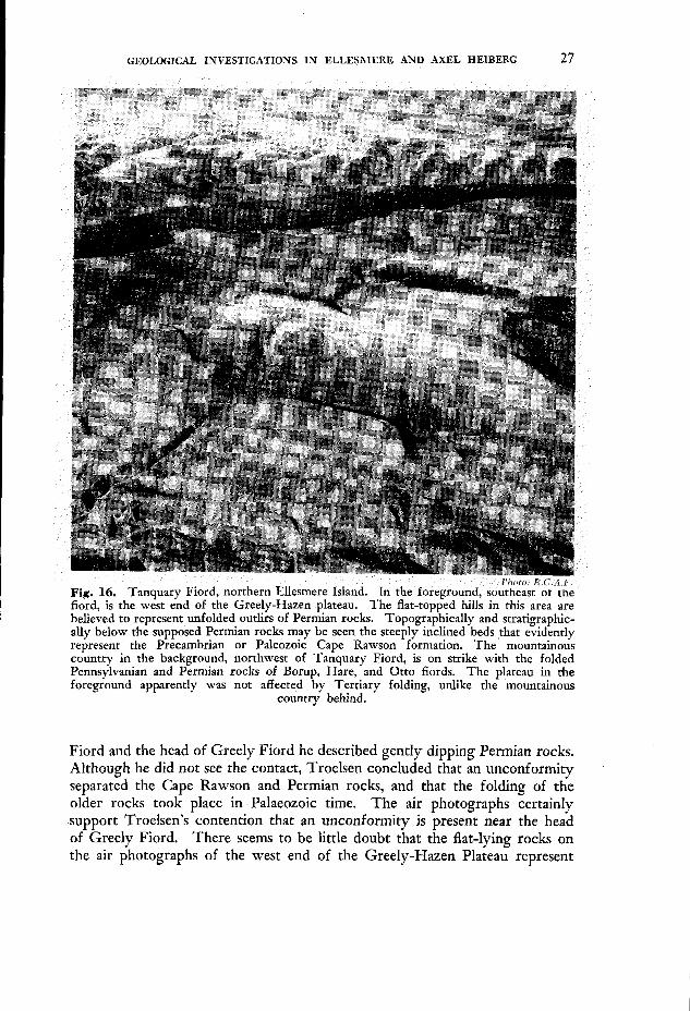
ally below the supposed Permian rocks may be seen the steeply inclined’beds that gid’ently represent the Precambrian or Paleozoic Cape Rawson formation. The mountainous country in the background, northwest of Tanquary Fiord, is on strike with the folded Pennsylvanian and Permian rocks of Borup, Hare, and Otto fiords. The plateau in the foreground apparently was not affected by Tertiary folding, unlike the mountainous
country behind.
Fiord and the head of Greely Fiord he described gently dipping Permian rocks. Although he did not see the contact, Troelsen concluded that an unconformity separated the Cape Rawson and Permian rocks, and that the folding of the older rocks took place in Palaeozoic time. The air photographs certainly support Troelsen’s contention that an unconformity is present near the head of Greely Fiord. There seems to be little doubt that the flat-lying rocks on the air photographs of the west end of the Greely-Hazen Plateau represent
28 GEOLOGICAL INVESTIGATIONS IN ELLESMERE AND AXEL HEIBERG
outliers of Permian (and possibly also Pennsylvanian) rocks resting uncon- formably upon the intensely folded Cape Rawson beds (Fig. 16). If the undisturbed rocks are of Pennsylvanian or Permian age, the Greely-Hazen Plateau, although probably folded in Palaeozoic time, was not deformed during she Tertiary orogeny that affected the areas to the northwest and southeast. In other words, the most extensive plateau area of northern Ellesmere Island may represent a region unaffected by Tertiary earth movements that is flanked by mountainous areas affected by Tertiary orogeny.
Our conclusions regarding the later structural history of central and northern Ellesmere Island may be summarized as follows.
(1) On Fosheim Peninsula, in southwestern Grant Land, and in Bay Fiord, structural deformation took place in Tertiary time, after the deposition of the strata known as the Eureka Sound group.
( 2 ) In west central Ellesmere Island, no deposits (other than of Pleis- tocene and Recent age) have been found that are younger than this orogeny.
( 3 ) The belt of Tertiary orogeny extends farther to the east than the older, Palaeozoic, orogenic belt.
(4) Probable extensions of this Tertiary orogenic system occur in central Grant Land and on Judge Daly Promontory.
( 5 ) Evidence from air photographs suggests that the Greely-Hazen Plateau, although flanked by Tertiary fold belts, was not deformed in Tertiary time.
(6) The areas of Tertiary orogeny in central and northern Ellesmere Island seem to correspond to the regions of greatest relief and physiographic immaturity.
Appendix. Notes on wildlife
Eureka has been visited by several zoologists: J. S. Tener in 1951, P. F. Bruggemann in 1953 and 1954, and ,by S. D. MacDonald and D. Parmelee, both in 1955. T o date the only publication that has appeared on the wildlife of the area is the report by Tener ( 1954), which concerns the musk ox. A complete list of the known mammals and birds will probably soon be published by MacDonald. Although we have no pretensions as zoologists the following notes are offered to supplement the observations of the various specialists mentioned above because these notes include information on many areas not visited by them.
Wolf: Judging from the number of tracks seen, wolves are fairly common throughout the region visited. A total of 19 animals was seen.
Fox: Tracks of arctic fox were common but fewer than ten animals were seen.
GEOLOGICAL INVESTIGATIONS IN ELLESMERE AND AXEL HEIBEKG 29
Weasel: Tracks of two weasels, but no animals, were seen.
Polar bear: Bears are apparently rare throughout the ' region. Tracks (possibly of one and the same animal) were seen south of Skraeling Point and in Hare Fiord. A single animal was seen in Vesle Fiord, on September 1.
Ringed seal: Seals were first seen sleeping on the ice in Borup Fiord, on May 11. Thereafter they became increasingly abundant in Greely, Hare and Canyon fiords. By early June we generally saw' up to ten. a day in these areas. When we travelled down Eureka Sound in August the density of the seal population seemed to increase towards Bay Fiord. In August, 19 seals were seen resting on a single large ice pan just north of Vesle Fiord. In this area we usually had two or three seals around the camp and the canoe.
Musk ox: It is well known that musk oxen are abundant on Fosheim Penin- sula. Sizable herds were also seen in Borup Fiord, Hare Fiord, near the mouth of Otto Fiord, near East Cape, west of Skraeling Point and in the Bay Fiord region. Our total count for the season was 278 animals, of which at least 61 were calves. The count of calves represents a minimum figure as the total includes animals seen too far away to distinguish adults from-young. I t seems to have been a good year for the musk oxen: two herds were seen each of which comprised 12 adults and 8 calves.
Caribou: Caribou are evidently very rare in the region visited. Nine animals were seen near East Cape and tracks attributed to very small herds were seen at Butter Porridge Point, Vesle Fiord, and Slidre Fiord.
Hare and lemming: Hares were abundant wherever we went and lemmings occurred in prodigious numbers this year.
Loon: About ten red-throated loons were seen during the season.
Eastern brant: On June 16 one pair of brant was seen on the north coast of Nansen Sound between Otto and Hare fiords, where they were feeding with snow geese.
Snow gooee: A very common nesting species throughout the region visited. The first pair was seen in Hare Fiord, on May 31. Several nests were found and broods, generally comprising five young, were nated in July. An esti- mated 200 snow geese were seen in Irene Bay and inner Bay Fiord, of which more than half were young. In 1955 several flocks of adult snow geese were seen in central Ellesmere Island and on the west coast of Axel Heiberg Island, but they were seldom accompanied by young. This year only one flock was seen without young.
King eider and old-squaw:. Both species were first seen on July 1, at\ Iceberg Point, and from then on they were common.
30 GEOLOGICAL INVESTIGATIONS IN ELLESMERE AND AXEL HEIBERG
Gyrfalcon: On August 9 a gyrfalcon nest was found on a low cliff near the coast of Eureka Sound, about 9 miles east of Blue Man Cape. The family included two young, fully fledged but barely able to fly. Another group of four was noted near the head of Bay Fiord. In September gyrfalcons descended upon the weather station in force, At one time there were 11 individuals perched on the antenna masts and wires.
Ptarmigan: Ptarmigan are fairly common residents. They were only rarely seen in the spring and during the nesting season, but several broods of up to 13 young were encountered during the last week of August and in early September.
Knot and ruddy turnstone: These two shore birds are probably the most common nesting species in the region. Both were first sighted in the pass between Hare and Otto fiords on May 13.
Jaeger: Long-tailed jaegers are a very common nesting species throughout the region; the first were seen in Hare Fiord on June 4. Parasitic jaegers are relatively rare. Only six were seen during the season.
Thayer’s gull: Gulls tentatively identified as this species were first sighted at Degerbols Island in Otto Fiord on June 3. During the season about 15 of these birds were seen.
GLaucus gull: About 25 gulls, almost certainly this species, were seen near Thumb Mountain at the head of Irene Bay.
Arctic tern: Terns were first seen at Iceberg Point on July 1. They mere very common after that date. Apparently they nest in great numbers on the small islet at the mouth of Vesle Fiord.
Snowy owl: About 30 owls, including three broods, were observed during the season.
References
(Arctic Circular) 1954. Police patrols to Axel Heiberg and Devon islands. Arctic Circu-
Armstrong, Terence and Brian Roberts. 1956. Illustrated ice glossary. Polar Record 8:
Bentham, Robert. 1941. Structure and glaciers of southern Ellesmere Island. Geog. J. 97: 36-45.
Blackadar, R. G. 1954. Geological reconnaissance north coast of Ellesmere Island, Arctic Archipelago, Northwest Territories. Geol. Surv., Can., Paper 54-10, 22 pp. and map.
Christie, R. L. 1955. Geological observations, 1954, in Hattersley-Smith, 1955. Fortier, Y. O., A. H. McNair, and R. Thorsteinsson. 1954. Geology and petroleum
possibilities in Canadian Arctic Islands. Am. Assoc. Petrol. Geol., Bull. 38: 2075-109. Hattersley-Smith, G., et ai. 1955. Northern Ellesmere Island, 1953 and 1954. Arctic
Heywood, W. W. 1954. Arctic piercement domes. Can. Inst. Min. & Met., Trans. 58:
MacMillan, D. B. 1918. Four years in the white North. New York: Harper & Brothers.
lar 7: 34-6.
4-12.
8: 3-36.
27-32.
xiii + 415 pp.
GEOLOGICAL INVESTIGATIONS IN ELLESMERE AND AXEL HEIBERG 31
Nathorst, A. G. 1915. Tertiare Pfianzenreste aus Ellesmereland. Rept. Second Norwegian Exp. in the “Fram”, 1898-1902. No. 35, 16 pp.
Porsild, A. E. 1955. The vascular plants of the western Canedian Arctic Archipelago. Natl. Mus. Can., Bull. 135, 226 pp.
Sverdrup, Otto. 1904. New land; four years in the arctic regions. London: Longmans, Green, Vol. I, xvi + 496 pp.; Vol. 11, 5 0 4 pp.
Tener, J. S. 1954. A prelimnary study of the muskoxen of Fosheim Peninsula, Ellesmere Island, N.W.T. Can. Natl. Parks Br., Wildlife Mngt. Bull., Ser. I., No. 9, 34 pp.
Thorsteinsson, R. 1955. Geology of Cornwallis and Little Cornwallis islands, Arctic Archipelago, Northwest Territories. University of Kansas: unpublished Ph.D. thesis. (Geol. Surv., Can., Mem. 294, in press).
Thorsteinsson, R. and Y. 0. Fortier. 1954. Report of progress on the geology of Corn- wallis Island, Arctic Archipelago, Northwest Territories. Geol. Surv., Can., Paper 54-24, 25 pp. and map.
Tozer, E. T. 1956. Geological reconnaissance, Prince Patrick, Eglinton, and western Melville islands, Arctic Archipelago, Northwest Territories. Geol. Surv., Can., Paper 55-5, 32 pp. and map.
Troelsen, J. C. 1950. Contributions to the geology of northwest Greenland, Ellesmere and Axel Heiberg islands. Medd. om Gr@nland, 149, No. 7 : 1-86.
1952. Geological investigations in Ellesmere Island, 1952. Arctic 5: 199-210.
Vibe, Christian. 1948. Langthen og nordpaa, Skildringer fra “Den Danske Thule- og Ellesmereland-ekspedition 1939-40”. Copenhagen: Gyldendal, 199 pp. and map.