Embed Size (px)
Citation preview
41llSSW0ei97 0829 PARKIN
GEOLOGICAL RSPOM/&B MAP
TO ACCOlffidNY WORK
SUBMITTED BOH ASSESSMENT
010
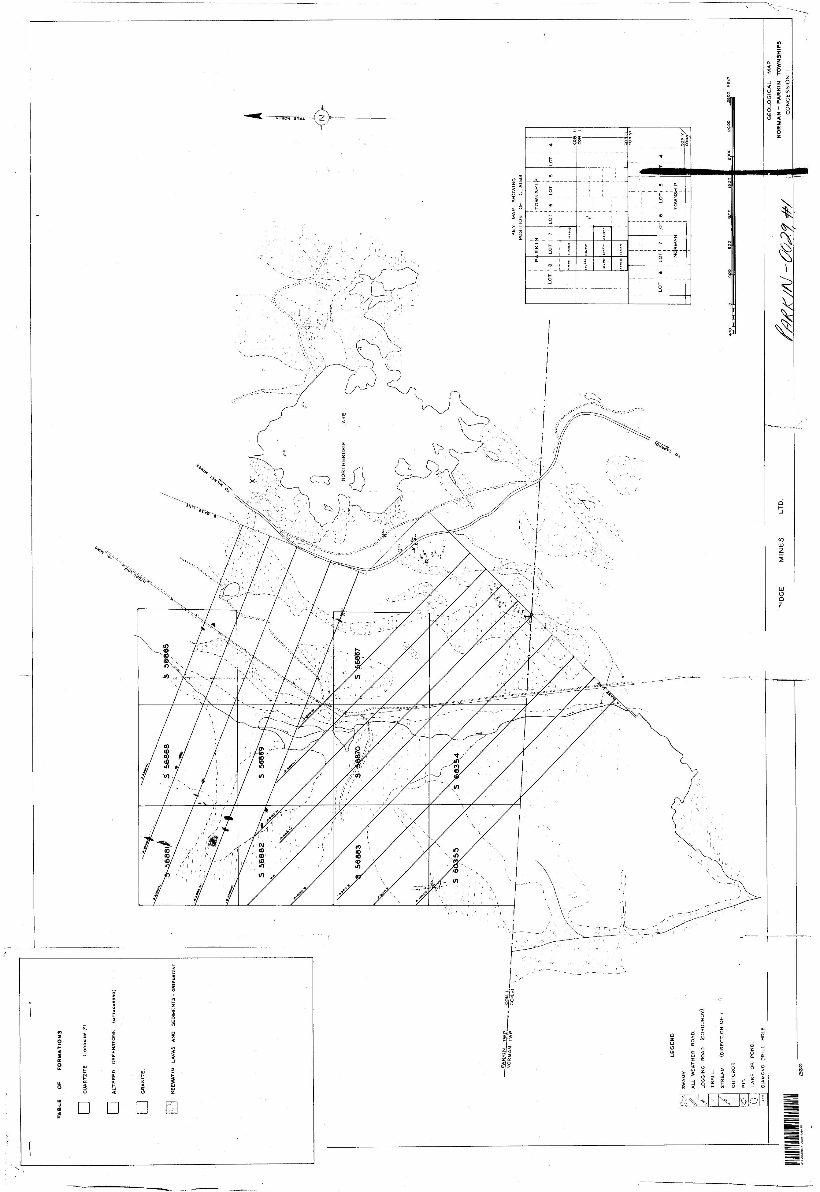
This consists of 10 contiguous claims in Parkin Twp. No*. 3 56865
3 56867 - 56870S 56881 - 56883S 60354,- 60355
Owuere: Northbridge Mines Ltd.
Surrey Peftejst February - April 1953.
Ore rotors: Personnel of ^falconbridge Nickel Minea, Faloonbrldge, Ontario.
]fa\yoduot ion l
'She grrap of claims is situated as follows:-1 claim louth east corner, south half lot 8 concession 22 claims south half lot 7 concession Z3 claims east half of lot 8 concession l 3 claims west half of let 7 concession l l claim centre of east half of lot 7 concession l
The claims which comprise the western portion of the Northbridge property are f ea* the most part fairly heavily timbered, the non-wooded areas being swamp covered*
Outcrops are practically non-existent in the southern part of the claims, but are a little more numerous in the northern half.
The property is liberally covered with erratic boulders embedded in a thick glacial drift overburden.
Access may be made to the property through a well cut hydro road, adjoining the Gapreol-Mllnet road to the hydro power line which runs across the claims from south to north.
The Capreol-Uilnet Mine road runs through the Northbridge property
about 600 ft. east of the claims.
Geology of the Areat
The northern half of the clair\s consist uf massive greenstone, inter bedded with a pure white quartzite. It is not possible to determine any dip or
strike of the individual beds or flows of the greenstone, due to the scattered
nature of the outcrops.
The quartzite mass,^which is very pure and contains fine pyrite cubes,
occurs as a ridge trending N 300 E across the claims.
- a ~
of the Area; (Cont'd)
In the southern claims, there Is one outcrop on the side of a high ridge, which consists of a very basic looking rock, cut by a granite dyke. This basic rock may be a phase of the greenstone, or nay be basic rim sur rounding the Algcnan granite, the contact of which should pass through the claims, but was not detected owing to the thick swamp, timber and drift cover*
All rocks in this property show a high degree of silicification, this being probably a consequence of the granite Intrusion, also they all dis play a consistent, but very weak scattering of pyrite throughout.
*
Shearin and
No shearing of any norite was found in the claims, and mineralization, apart from the pyrite mentioned above, is absentt
GAB:Jep June 4, 1953
G. A. Brown Geologist
. ,*.
S'JBlgTTSD
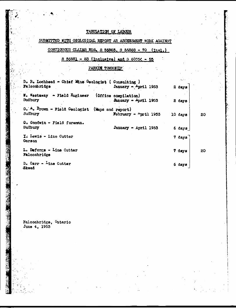
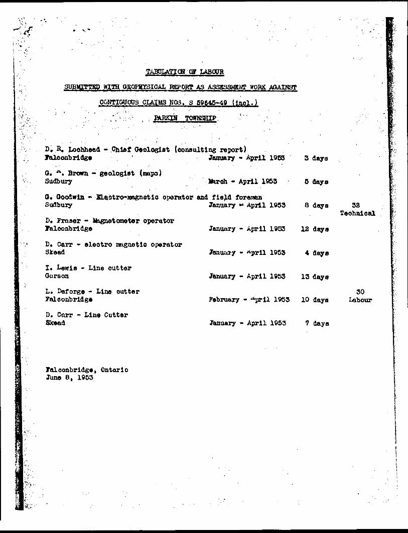
TABDIATICH Cg LABOUR
GSQL03ICAL RSPORT AS ASSESSMENT WORK AQAIK3T
CONTIGUOUS CLAIMS SOS, 8 56865. 8 55866 -.70 (inol.)
B 56881 - 63 IQlualYo) aai 3 6035- 5
PARKIR TQgNaEIIP
D. B. Loohhead - Chief Hine Falooribrldge
{ Consulting ) January -, April 1953
W. #estaway - Field Engineer (Office ocanpllation) Sudbury January * April 1053
0. A. Srown - Field Geologist (Maps and report)Sudbury Fobruary - -"pril 19B3
O. Goodwin - Field fotrenan* Sudbury
I. Lewis - Line Cutter OarBon
L* Deforce - Line Cutter Falconbridge
D. Carr - Line Cutter Skead
January - April 19B3
2 day*
Z days
10 daya
6 days
7 days
7 days
6 days
20
falconbridge, Ontario June 4, 1953
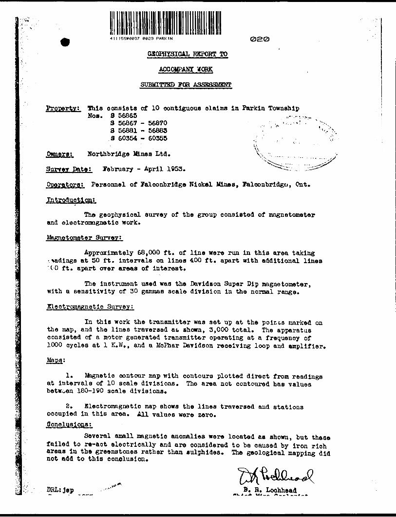
11 l 15SW0897 8029 PARKIN 020
GSOPHTJ3ICAL REPORT TO
ACCOMPANY tfOHK
SUBMITTED FOR ASSESSMENT
Property! 5his consists of 10 contiguous olaima in Parkin Township Nos. S 56865 ,.~.-,.-
3 56867 - 56870 , ^ - - '' 3 56881 - 56883 3 60354 - 60355
'i ' f.' .
V^
Owners t Horthbriflgo Mines Ltd. \\ .. .
Survey pate i February - April 1953. *"v-^:--. ,
Operators: Personnel of Falconbridge Niokol Vines, Talconbridgo, On t.
Introduction:
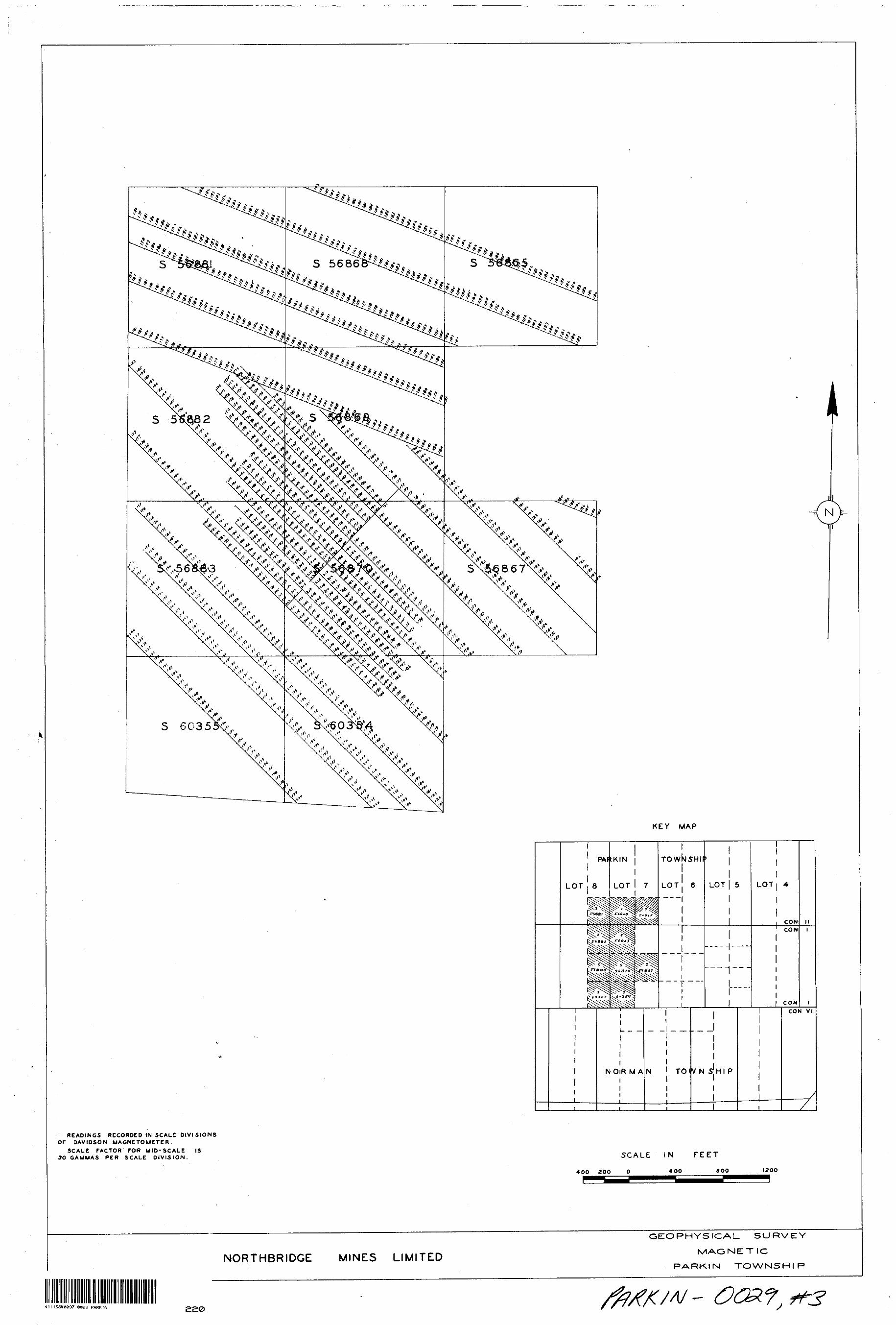
The geophysical surrey of the group consisted of magnetometer and electromagnetic work.
Magnetometer Surveyt
Approximately 68,000 ft. of line were run in this area taking -.fadings at 50 it. intervals on linea 400 ft. apart with additional lines UO ft. apart over areas of interest.
The instrument used was the Davidson Super Dip magnetometer, with a sensitivity of 30 gammas scale division in the normal range*
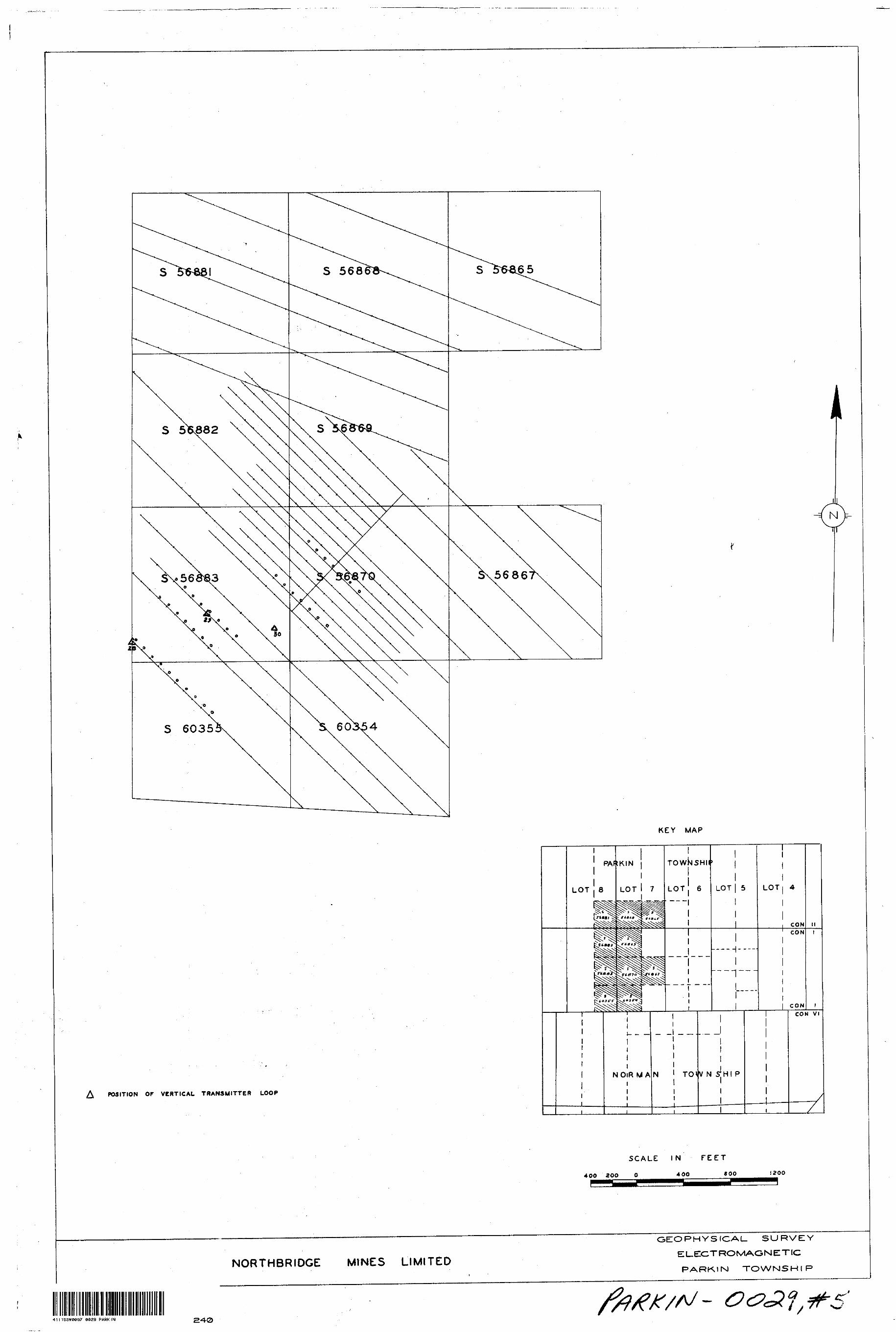
Kleotroaafinetic Surrey:
In this work the transmitter was set up at the poir.cs marked on the map, and the lines traversed at shown, 3,000 total. The apparatus consisted of a motor generated transmitter operating at a frequency of 1000 cycles at l K.W., and a MoPhar Davidson receiving loop and amplifier.
Maps:
1. Magnetic contour map with contours plotted direct from readings at intervals of 10 scale divisions. The area not contoured has values betwoen 180-190 scale divisions.
2. Electromagnetic map shows the lines traversed and stations occupied in this area. AU values were zero.Conclusions!
Several small magnetic anomalies were located as shown, but these failed to r*-act electrically and are considered to be caused by iron rich areas in the greenstones rather than sulphides. The geological mapping did not add to this conclusion.
DRL:Jep B. R. Loohheadwu j H^ vi* M -. /H -, - n A M J M A.
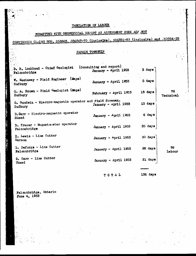
TABULATICH OF LABOUR
' SUBMITTED WITH GBORffifSICAI. REPORT AS ASSSSSISNT WORK t&P \M3T
CONriGUOU3 CLaIM3r N03. S56865. 356867-70 (inclusive). 356881-83 Cinclusive) and -60354-55
; PARKIN TOWNSHIP
W* Weetaway - Jleld ISnglneer (Maps) Sudbury
G. A. Brown - Field Oeologlot Sudbury
O. Goodwin - Slectro-macnetlo operator and field foreman.
Sudbury
D. Carr - Kleotro-masnetlo oparator Skead
D. Fraser - liagnetoueter operator Faloonbrldee
I. Lewie - Line Cutter Garson
L. Def orge - Line Cutter faloonbrldge
D. Carr - Lino Cutter Skead
3 days
January - April 1983 5 4*y*
February - April 1953 1C days
January - April 1953 15 days
January - April 1953 6 days
January - April 1953 35 days
January - April 1953 30 days
January - April 1953 28 daya
January - April 1953 21 days
78Technical
78 Labour
TOTAL 156 days
falconbridge, Ontario June 4, 1953
41I1ESW0097 0029 PARKIN030
GEOLOGICAL MAP AND REPORT
TO ACCOMPANY
STOMTTTfiD ASSESSMENT WORK
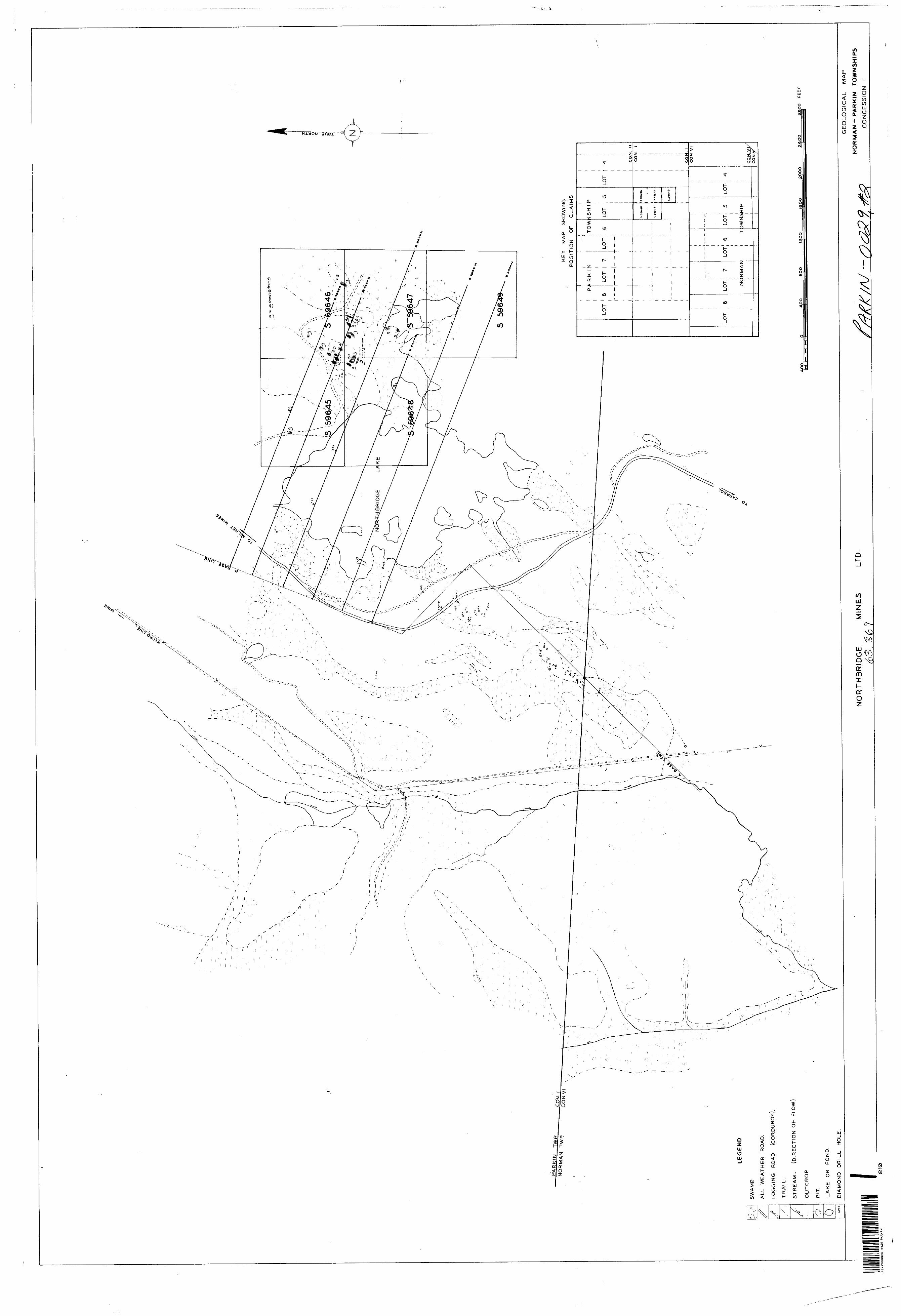
Property ;- Five olaims (S 59645 - S 59649) In Concession 1. Parkin Twp.Owners!. Northbridge Uinas Limited*
Surrey Dates; January - ^ril 1953.
Operators: Personnel of Falconbridge Nickel Mines Limited, Falconbridge, Ont.Introduction t
(a) The group of claiaa is situated as follows:4 claims in the north half of lot S, concession ll claim in the north east corner of the south half of lot 5,concession 1.
The area, being situated on the north east shore of Northbridge Lake, and in fact including the north-east corner of the lake, is very swampy, with scattered outcrops usually in the form of long ridges* The low areas are heavily covered with glacial drift, having been found in one drill hole to be about 45 feet thick. The drift is liberally studded with erratic boulders of pink granite, very pure white quartzite, and much diabase, these all having been transported from the Cobalt-Bruce inlier to the north.
The property is fairly thickly timbered, and the underbrush further obscures the outcrops.
(b) Access to the property is readily afforded by means of a good gravel toad from Capreol (0^ miles), and to the claims by means of a well-cut logging road which leaves the Oapreol-Milnet Mine road at a point about 600 feet north-north-east of the lake* This road is usually very wet in spite of its being corduroyed.
The grid on which this survey was carried out is part of that which covers the whole of the Northbridge property*
Geolog of the
The area of the claims consist entirely of greenstone, that is, an altered interbedded series of sediments and basic lavas. However owing to the sparse scattering of the outcrops, it was not possible to determine either the dip or the strike of any individual beds or flows. The greenstones are for the most part fine-grained, greenish weathered rocks, which when they outcrop do so as very large masses.
- K -
Shear zones and
A fairly wall defined zone of shearing exists throughout the claims in a N SO0 g direction* This zone consists of heavily fractured greenstone, the fractures being infilled with quartz. It is this filling and the silicification of the surrounding rocks, which has caused the long ridges which parallel the direction of the shearing* In one outcrop, on the strike of the shearing, the greenstone has been entirely altered to a very soft graphitic material.
This zone is very well defined by means of a magnetic anomaly which is directly over the disturbed area throughout the claims. The material that is actually present in the shears and is causing the anomaly is unknown but it is probably scattered magnetite*
6?/?. /3/Zrtt/TL
OAB:jep June 4, 1953
O. A. Brown Geologist
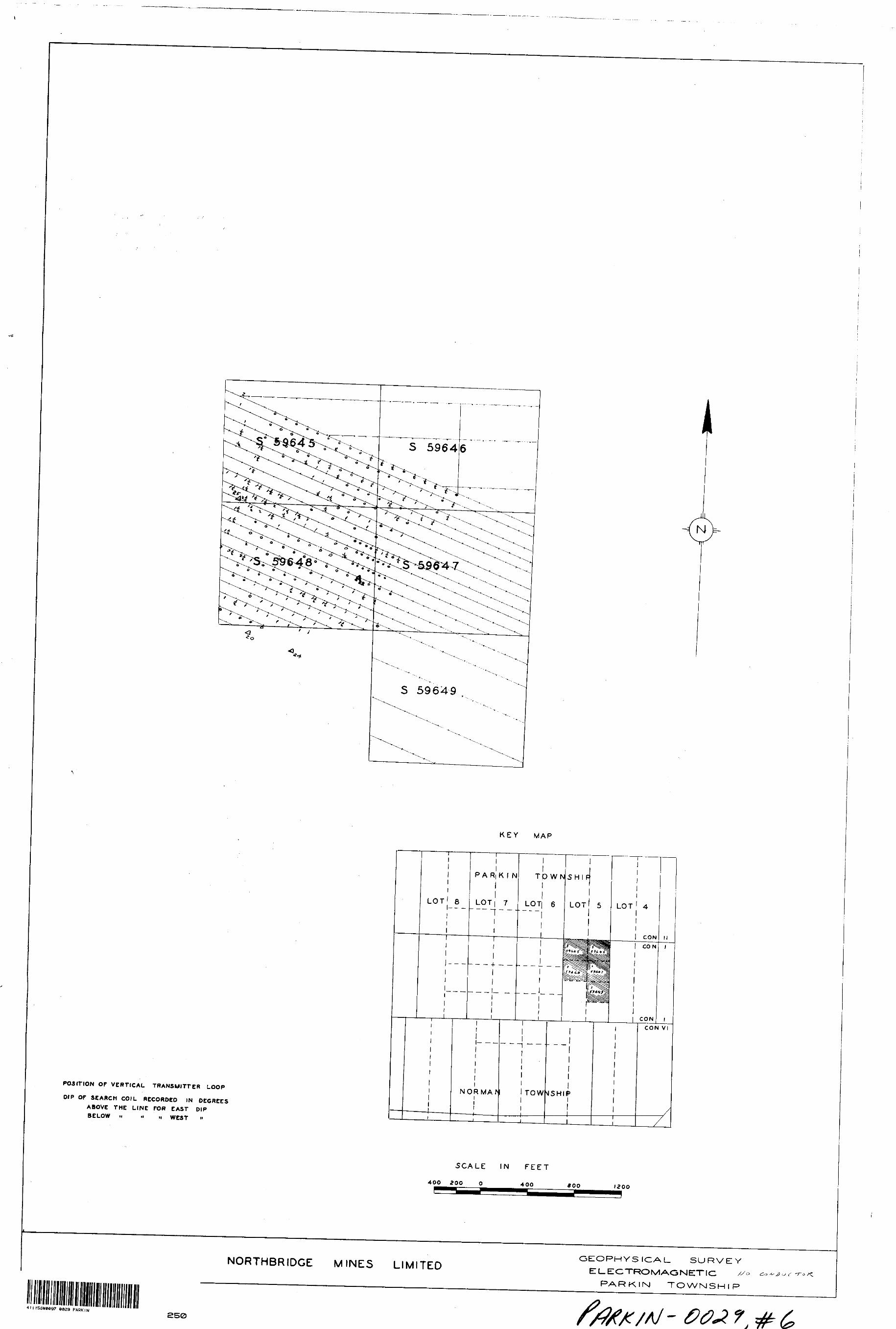
GEOPHYSICAL REPORT AMD MAPS TO
ACCOMPANY WORK
SUBMITTED FOR ASSESSMENT
Property:, *ive claims ( S 59645 - 59649) in concession l Parkin Twp.
Owner s t Northbridge Mines Ltd*
Survey, Date.s: January - April 1953.
Operators t Personnel of Talconb ridge Nickel Mines Ltd. Falconbridge, Ont.
Introduction:
The geophysical survey of this group of claims consisted of both
mac-net i c and electromagnetic work.
Mapne t omet eiyjjarvey:
7or this survey 45,000 feet of line were covered with the magnetometer. Readings were taken at 50 foot intervals on lines 100 feet
apart as shown on the accompanying map.
The instrument used was the Davidson Super Dip magnetometer with a sensitivity of 30 gammas scale division, in the normal range.
Electromagnetic Survey:.
In this work the transmitter was set up at the points marked on the
map and the lines traversed as shown (26,500 feet total). The apparatus con sisted of a motor generator transmitter operating on a frequency of 1000 cycles at l K.W. and a McPhar Davidson receiving loop and amplifier.
Maps:
Twp maps were submitted with this report.
1. Magnetic contour maps with contours plotted at 10 scale division
intervals. The uncontoured area has values between 180-190 scale divisions.
2. Electromagnetic map shows the lines actually traversed and the
stations occupied. Actual electromagnetic readings are shown on the accompanying
map.
Remarks:
The magnetic survey produced a wide zone of high values trending in
a NSO*^ direction throughout the proparty. This anomaly was investigated by the
electro-magnetic work and no indication of the presence of any conductor was given.
From geological mapping it was found that this anomaly coincided with a
wide band of shearing. There was no indication of any material in the shears that
would cause the anomaly.
D.H. Lochhead
41 l 1SSW8097 8829 PARKIN
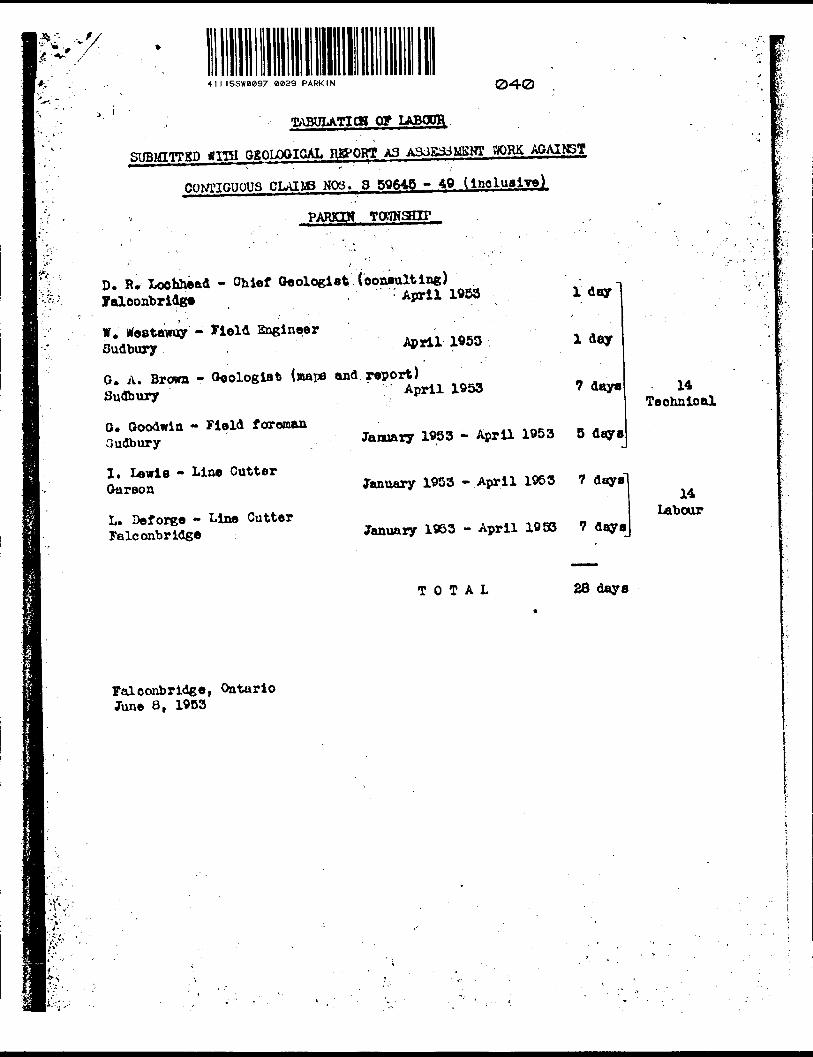
TABUlATICg OF LABODH
SUBMITTSD *ITH SSOLOGIOAL RgQRT A3 BOR& AGAINST
CONTIGUOUS CLAIIS N03. 3 5Q&45 - 40 ( inclusive)
PARKIN
D. R. locfchead - Ohief Oeologiat (eotxaulting) Faloonbrldg. - April 1953
W. Weatwoy -' Sudbury
EngineerApril W53
O. A. Brown - Oeologlat (mape and report) Sudbury A?rl1 1953
O. Goodwin - Field foreman 3udbury
1. Lewis - Line Cutter Garson
L. Deforge - Line Cutter Falconbridge
l day
l day
7 day*
January 1983 - April 1V53 5 daya
January 1953 -April 1953 7 days
January 1953 - April 1993 7 days
14Technical
14 Labour
TOTAL 28 days
Falconbridge, Ontario June 8, 1963
TABDLATICH OF LABCPR
3UB1OTCHP WITH (ISOPHYSICAL REPORT A3 A3SB33M8MT WORK AQAIHST
CONTIOUOP3 CLAIMS N03. 3 89645-49 ( ihol.)
' TOWNSHIP v' ;
D. R. Loohhead - .Chief Geologist (consulting report)falconbridge " . January - April 1963 3 days
O. A. Brown - geologist {tnapo) Sudbury Jferoh - April 1953 5 days
O. Ooodwia - XLftOtro-nagnetio operator and fiejld foremenSudbury
D* Fraser - Ibgnetometer operator falconbridge
D* Carr - electro magnetic operator Skead
I* Lewis - Line cutter Gkirson
L. Deforge - Line cutter falconbridge
D. Carr - Line Cutter Skead
January ** April 1953 8 days 33Technical
January - April 1953 12 days
Jonuai-y - ^prll 1953 4 days
January - April 1953 13 days
30 Pebruary - -^prll 1953 10 days Labour
January - April 1953 7 days
falconbridge, Ontario June 6, 1953
b
; ~ V
-llael.l
TT - April 1955
-April 1953 9 (Jay*
: tartama7 -April 1953 8
T - April 19S3 12 day.
33Toohnlcal
y - 1953
30
T - April 1953 13 day*
rr - -prll 1953 10 day* Labour
r - April 1953 7 day*
•v ;
, - i.!
s ©T6SV l J365 j 4(00 , 9326~^r
^yj^^fif^.*^W?3^f.]
•**?i"*** •'~**
Spfi^^;^-^,,,fj&^xte-ftite*^'^ ^ ,n^s
IS;;iifes4^ fci^^^^^••••^^^^^^^^^^^•^•^•^^
^.•^jr;^V7 ^-?F^ ,,,,-,,^Clf^*^---"^"-. ".••-••i .Jfi'
(X) 30N3YI19H9/Y/
N/
-t-
JopC*: g lfi
H
li)UJ
\Ox
TA
BL
E
OF
F
OR
MA
TIO
NS
QU
AR
TZ
ITE
(L
OR
RA
INE
f)
AL
TE
RE
D
GR
EE
NS
TO
NE
(M
ETA
CA
BB
RO
)
GR
AN
ITE
.
KE
EW
AT
IN
LA
VA
S
AN
D
SE
DIM
EN
TS
- G
RE
EN
STO
NE
S&
RK
1N
T
W
NO
RM
AN
-SO
'NJ
CO
N. V
I
o
LE
GE
ND
SW
AM
P
ALL
WE
AT
HE
R
RO
AD
.
LO
GG
ING
R
OA
D
(CO
RD
UR
OY
).
TR
AIL
.
STR
EAM
- (D
IREC
TIO
N O
F t
OUTCROP
PIT.
LAKE OR POND.
DIA
MO
ND
D
RIL
L
HO
LE
.
41llS
SW
0e97
80
29
P
AR
KIN
S00
KE
Y
MA
P
SH
OW
ING
PO
SIT
ION
O
F
CL
AIM
S
MIN
ES
2&
OO
P
E6
T
GE
OL
OG
ICA
L
MA
P
NO
RM
AN
- P
AR
KIN
T
OW
NS
HIP
S
CO
NC
ES
SIO
N
l
\
-\
J-' •f
KEY
MAP
SHOW
ING
POSI
TION
OF
CL
AIM
S
LEG
EN
D
SW
AM
P
ALL
WE
AT
HE
R
RO
AD
.
LOG
GIN
G
RO
AD
(C
OR
DU
RO
Y).
TR
AIL
.
STRE
AM,
(DIR
ECTI
ON O
F PL
OW)
OUTCROP
PIT.
LAKE OR POND.
DIA
MO
ND
D
RIL
L
HO
LE,
, ^ P
^1
LO
T
81 r-
-
i i
^ R
K 1
LO
T
N | 7
—
— -
| L
OT
1-
t
—
——
TO
W
1 6
- -
—
NJS
H 1r
LOT
j 5
1 i
5 5
9*4
5
3S
9t4
fe
S5
9tX
t6
L-
.1..:..;,.
' i
! :
i i
! -
i i
' 1 1 1 l
LO
T
' 6
1 i i l
LOT
7
NC
JRM
AN
l
L-
LOT|
e
T
~
iS?W
7
*5?M
9
1 l i i LO
T
) 4
| 1
i i
i i 1LO
Ti
5l 1
3W
NS
HIP
1 ..-
4.., 1
LOT
——
—
l 1 co
r4.
lil
CO
N.
l
l i t i i i l C
Of
4
- 1
CO
N V
I
CO
NC
ON
.V
J/
Y
AO
OZ
80O
F
EE
T
NO
RT
HB
RID
GE
MIN
ES
LTD
.
41I1
5S
W0097
0829
PA
RK
IN210
GE
OLO
GIC
AL
MA
P
NO
RM
AN
- P
AR
KIN
T
OW
NS
HIP
S
CO
NC
ES
SIO
N
l
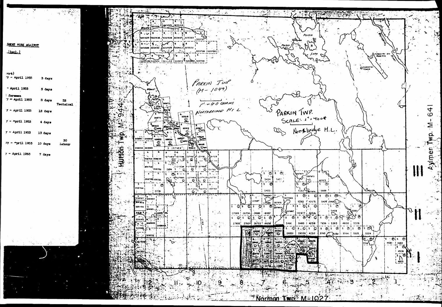
KEY MAP
READINGS R ECORDED IN SCALE DIVISIONS OF DAVIDSON MAGNETOMETER.
SCALE TACTOR FOR MID-SCALE I S JO GAMMAS PER SCALE DIVISION.
I2OO
NORTHBRIDGE MINES LIMITED
OEIO PHYSICAL. SURVEY
MAGNET 1C
PARKIN TOWNS H l P
11I15SW0*97 0029 PARKIN 220

O- ,S 59649^ j
KEY MAP
LOT' 8
P A Ri K l N
LOT i 7---f--
TP WNSHI
LOTI 6 LOT' 5 LOT ' 4
CON
CON
CON l
NORMAr TOW NSHIff
CON VI
7
READINGS RECORDED IN SCALE DIVISIONS OF DAVIDSON MAGNETOMETER.
SCALE FACTOR FOR MID-SCALE IS 30 GAMMAS PER SCALE DIVISION. SCALE IN FEET
400 200 400 *OO 1200
NORTHBRIDGE MINES LIMITEDGEOPHYSICAL SURVEY
MAGNET 1C.
PARKIN TOWNSHIP
0029 PARKIN 230
POSITION OF VERTICAL TRANSMITTER LOOP
KEY MAP
SCALE I N FEET
1200
NORTHBR1DGE MINES LIMITED
GEOPHYSICAL- S URVEY
ELECTROMAGNETIC
PARKIN TOWNSHI P
411155*0097 0029 PARKIN 240
KEY MAP
POSITION OF V ERTICAL TRANSMITTER LOOP
DIP OP SEARCH COIL ACCORDED IN DEGREES ABOVE T HE LINE TOR CAST DIP BELOW H M M WCST i'
LOT' 8
P A Ri K ( N
LOT i 7l
l- — -
TQ WN
LOT) 6
SHIP
LOT' s
-J — —
l NORMANl l TOW NSHIff*
l
LOT ' 4
CON
CON
CON
II
CON VI
X
SCALE IN FEET
400 200 40O (200
NORTHBRIDGE MINES LIMITEDGEOPHYS (CAL SURVEY
ELECTROMAGNETIC /PARKIN TOWN S H l P
4tll5SWeC97 0029 PARKIN
250