Embed Size (px)
Citation preview
Allnllal Geological Conference '96
~~~~~ Jllne 8-9,1996, [(ota [(illaballl, Sabah
Geology and hydrology of Tuaran
MAJEED M. FAISAL, SHARIFF A.K. OMANG AND SANUDIN HJ. TAHIR
University Malaysia Sabah Km 19, Jalan Tuaran Beg Berkunci 2073
88999 Kota Kinabalu, Sabah
Abstract: The study area located is in the western coast of Sabah between Telipok and Tuaran. The paper presents the geological setting and the hydrological condition ofthe study area and their relation, and attempts to determine the water balance based on available climatological data using Thornwaite method. Geological study indicates that the study area is underlain by Crocker Formation and Quaternary alluvium while hydrological condition based on water balance computation indicated that most of the water from precipitation fallover in the study area will be consumed by evapotranspiration leaving little water available for deep percolation and surface run off.
INTRODUCTION
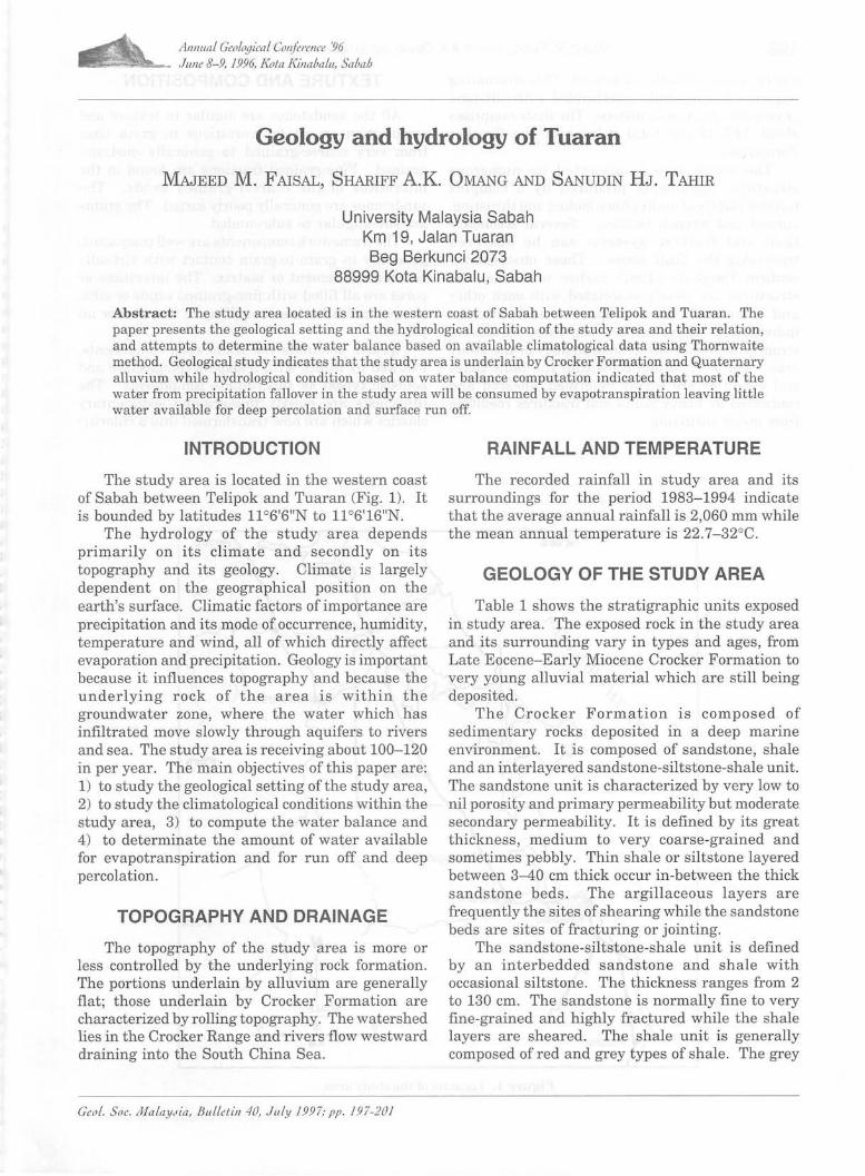
The study area is located in the western coast of Sabah between Telipok and Tuaran (Fig. 1). It is bounded by latitudes l106'6"N to llo6'16"N.
The hydrology of the study area depends primarily on its climate and secondly on its topography and its geology. Climate is largely dependent on the geographical position on the earth's surface. Climatic factors of importance are precipitation and its mode of occurrence, humidity, temperature and wind, all of which directly affect evaporation and precipitation. Geology is important because it influences topography and because the underlying rock of the area is within the groundwater zone, where the water which has infiltrated move slowly through aquifers to rivers and sea. The study area is receiving about 100-120 in per year. The main objectives of this paper are: 1) to study the geological setting of the study area, 2) to study the climatological conditions within the study area, 3) to compute the water balance and 4) to determinate the amount of water available for evapotranspiration and for run off and deep percolation.
TOPOGRAPHY AND DRAINAGE
The topography of the study area is more or less controlled by the underlying rock formation. The portions underlain by alluvium are generally flat; those underlain by Crocker Formation are characterized by rolling topography. The watershed lies in the Crocker Range and rivers flow westward draining into the South China Sea.
Geo!. Soc . III/alaYJia, BII.LLetin 40, JuLy 1997; pp . 197-201
RAINFALL AND TEMPERATURE
The recorded rainfall in study area and its surroundings for the period 1983- 1994 indicate that the average annual rainfall is 2,060 mm while the mean annual temperature is 22.7- 32°C.
GEOLOGY OF THE STUDY AREA
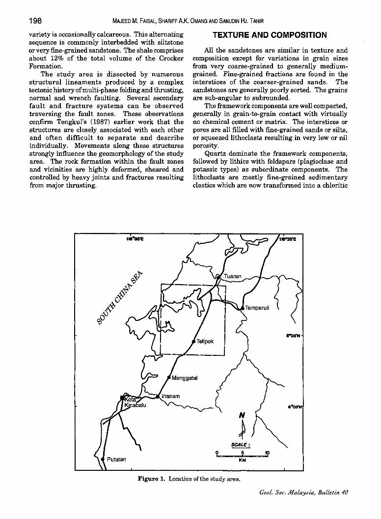
Table 1 shows the stratigraphic units exposed in study area. The exposed rock in the study area and its surrounding vary in types and ages, from Late Eocene-Early Miocene Crocker Formation to very young alluvial material which are still being deposited.
The Crocker Formation is composed of sedimentary rocks deposited in a deep marine environment. It is composed of sandstone, shale and an interlayered sandstone-siltstone-shale unit. The sandstone unit is characterized by very low to nil porosity and primary permeability but moderate secondary permeability. It is defined by its great thickness, medium to very coarse-grained and sometimes pebbly. Thin shale or siltstone layered between 3-40 cm thick occur in-between the thick sandstone beds. The argillaceous layers are frequently the sites of shearing while the sandstone beds are sites of fracturing or jointing.
The sandstone-siltstone-shale unit is defined by an interbedded sandstone and shale with occasional siltstone. The thickness ranges from 2 to 130 cm. The sandstone is normally fine to very fine-grained and highly fractured while the shale layers are sheared. The shale unit is generally composed of red and grey types of shale. The grey
198 MAJEED M. FAISAL, SHARIFF A.K. OMANG AND SANUDIN HJ. TAHIR
variety is occasionally calcareous. This alternating sequence is commonly interbedded with siltstone or very fine-grained sandstone. The shale comprises about 12% of the total volume of the Crocker Formation.
The study area is dissected by numerous structural lineaments produced by a complex tectonic history of multi-phase folding and thrusting, normal and wrench faulting. Several secondary fault and fracture systems can be observed traversing the fault zones. These observations confirm Tongkul's (1987) earlier work that the structures are closely associated with each other and often difficult to separate and describe individually. Movements along these structures strongly influence the geomorphology of the study area. The rock formation within the fault zones and vicinities are highly deformed, sheared and controlled by heavy joints and fractures resulting from major thrusting.
TEXTURE AND COMPOSITION
All the sandstones are similar in texture and composition except for variations in grain sizes from very coarse-grained to generally mediumgrained. Fine-grained fractions are found in the interstices of the coarser-grained sands. The sandstones are generally poorly sorted. The grains are sub-angular to subrounded.
The framework components are well compacted, generally in grain-to-grain contact with virtually no chemical cement or matrix. The interstices or pores are all filled with fine-grained sands or silts, or squeezed litho clasts resulting in very low or nil porosity.
Quartz dominate the framework components, followed by lithics with feldspars (plagioclase and potassic types) as subordinate components. The lithoclasts are mostly fine-grained sedimentary clastics which are now transformed into a chloritic
Figure 1. Location ofthe study area.
Geol. Soc. MalaYJia, Bulletin 40
AGE
Quaternary
Late Eocene to lower Miocene
ROCK FORMATION
Alluvium
Crocker Formation
GEOLOGY AND HYDROLOGY OF TUARAN
Table 1. Local stratigraphic column.
UNIT
Shale
Shalesandstone
Interbedded
GENERAL CHARACTER
Unconsolidated gravel, sand and silt with minor amounts of clay deposited along the rivers or streams and their tributaries. Includes natural levee and flood plain deposit.
This unit is composed of two types of shales, red and grey. It is a sequence of alteration of shale with very fine siltstone.
It is a sequence of interlayering of permeable sandstone with impermeable shale. The permeability of this unit is quite variable. Groundwater in this unit tend to be under semi-confine to confine system.
WATER-BEARING PROPERTIES
199
Gravelly and sandy, portions are highly permeable and yield large quantities of water. Importantto groundwater development.
It has no significance to groundwater development due to its impermeable characteristics.
Little importance to groundwater, provide some water but not enough for groundwater development.
Sandstone Light grey to cream colour, medium Importance to groundwater. to coarse grained and sometimes pebbly. It is highly folded, faulted, jointed, fractured, occasionally cavernous, superficially oxidized and exhibit spheroidal weathering.
or illitic or interlayered illite-smectite variety. The other lithoclasts consist of cryptocrystalline silica. The quartz framework are mostly monocrystalline, indicating a plutonic origin while others are polycrystalline suggesting a metamorphic derivative.
cryptocrystalline siliceous varieties. The development of chemical cement is likewise very retarded as shown by the low interstitial calcite component in only two samples. The pronouncedly minimal diagenetic changes suggest the absence or very restricted circulation of pore fluids because of the low to total absence porosity in the rocks. The overall texture (grain size, sorting,
angularity) and composition indicate that the sandstones have undergone very short transport from the plutonic/metamorphic provenance.
DIAGENESIS
The compacted nature of the sandstones resulting in very low to nil visual porosity of the sandstones indicate a thick overburden and/or a long history of burial.
Diagenetic effects are almost absent in the quartz sands except for rare overgrowths. On the other hand, the only diagenetic effects on the feldspar are the rare and partial alteration to calcite or clay. The effects on the lithoclasts are also minimal such as the alteration to finely-crystalline clay (chlorite, rare illite-smectite) or
July 1997
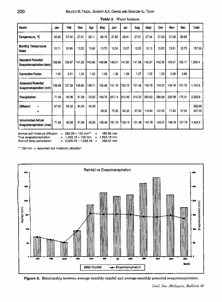
WATER BALANCE
Hydrological studies include collection of precipitation and temperature data from the major stations in the study area and its surrounding. These data were used to compute for water balance to show the amount of rainfall available for evapotranspiration and surface runoff and deep percolation.
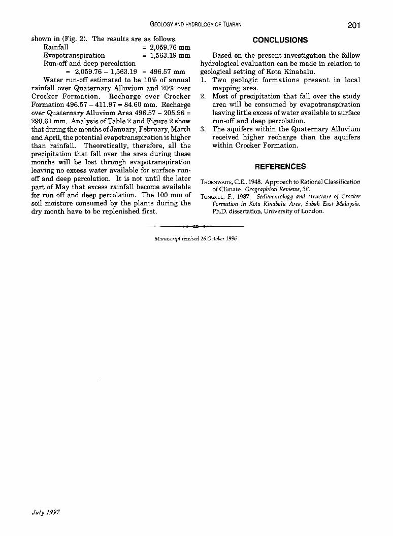
The values for potential evapotranspiration were computed using the Thornwaite method (Thornwaite, 1948). This method mainly required temperature and precipitation data. The water balance computation is shown in Table 2. The relation between average monthly rainfall and average monthly potential evapotranspiration are
200
Month Jan
Temperature, 'l:: 26.80
Monthly Temperature 12.71
Index
Standard Potential 138.96
Evapotranspiration (mm)
Correction Factor 1.00
Assessed Potential 138.98
Evapotranspiration (mm)
Precipitation 71.48
Different - 67.50
+
Uncorrected Actual 71.48
Evapotranspiration (mm)
Annual soil moisture diffusion True evapotranspiration Run-off deep percolation
MAJEED M. FAISAL, SHARIFF A.K. OMANG AND SANUDIN HJ. TAHIR
Feb Mar Apr
27.04 27.51 28.11
12.89 13.22 13.66
139.87 141.59 143.80
0.91 1.03 1.03
127.28 145.83 148.11
60.96 51.58 93.52
66.32 94.25 54.59
60.96 51.58 93.52
282.66 -100 mm** 1,463.19 + 100 mm 2,059.76 - 1 ,563.19
Table 2. Water balance.
May Jun
28.16 27.95
13.70 13.54
143.98 143.21
1.08 1.06
155.48 151.79
184.78 227.14
29.30 75.35
155.48 151.79
182.66 mm 1,563.19 mm
496.57mm
Jul Aug
29.81 27.51
13.27 13.22
141.82 141.58
1.08 1.07
153.16 151.48
213.48 219.33
60.32 67.85
153.16 151.48
Sept
27.34
13.10
140.97
1.02
143.78
260.62
116.84
143.78
** 100 mm = assumed soil moisture utilization
.00 Rainfall vs Evapotranspiration
110
mm
/ 1111111
r-- - / 10
o - MAY -mm Rainfall -+- Evapotranspiration I
Oct Nov Dec Total
27.33 27.08 26.86
13.02 12.91 12.75 157.99
140.56 139.97 139.17 1,695.4
1.02 0.98 0.99
143.37 148.78 137.79 1,745.8
280.98 220.58 175.31 2,059.8
282.66 137.61 71.80 37.52 597.09
143.37 148.78 137.79 1,463.2
--
"""-
10
o OCT NOV DEC
Figure 2. Relationship between average monthly rainfall and average monthly potential evapotranspiration.
Geol. Soc. iI1alaYJia, Bulletin 40
GEOLOGY AND HYDROLOGY OF TUARAN 201
shown in (Fig. 2). The results are as follows. Rainfall = 2,059.76 mm Evapotranspiration = 1,563.19 mm Run-off and deep percolation
= 2,059.76 - 1,563.19 = 496.57 mm Water run-off estimated to be 10% of annual
rainfall over Quaternary Alluvium and 20% over Crocker Formation. Recharge over Crocker Formation 496.57 - 411.97 = 84.60 mm. Recharge over Quaternary Alluvium Area 496.57 - 205.96 = 290.61 mm. Analysis of Table 2 and Figure 2 show that during the months of January, February, March and April, the potential evapotranspiration is higher than rainfalL Theoretically, therefore, all the precipitation that fall over the area during these months will be lost through evapotranspiration leaving no excess water available for surface runoff and deep percolation. It is not until the later part of May that excess rainfall become available for run off and deep percolation. The 100 mm of soil moisture consumed by the plants during the dry month have to be replenished first.
CONCLUSIONS
Based on the present investigation the follow hydrological evaluation can be made in relation to geological setting of Kota Kinabalu. 1. Two geologic formations present in local
mapping area. 2. Most of precipitation that fall over the study
area will be consumed by evapotranspiration leaving little excess of water available to surface run-off and deep percolation.
3. The aquifers within the Quaternary Alluvium received higher recharge than the aquifers within Crocker Formation.
REFERENCES
THORNWAITE, c.E., 1948. Approach to Rational Classification of Climate. Geographical Reviews, 38.
TONGKUL, F., 1987. Sedimentology and structure of Crocker Formation in Kota Kinabalu Area, Sabah East Malaysia. Ph.D. dissertation, University of London .
.. ., .. Manuscript received 26 October 1996
JuLy 1997