Embed Size (px)
Citation preview
Turkish Journal of Earth Sciences (Turkish J. Earth Sci.), Vol. 12, 2003, pp. 175-198. Copyright ©TÜB‹TAK
175
Geology and Hydrothermal Alteration of the Ayd›n-Salavatl› Geothermal Field, Western Anatolia, Turkey
‹SMA‹L HAKKI KARAMANDERES‹1 & CAH‹T HELVACI2
1 Maden Tetkik ve Arama Genel Müdürlü¤ü (MTA), Ege Bölge Müdürlü¤ü,TR-35042 Bornova, ‹zmir - Turkey
2 Dokuz Eylül Üniversitesi, Mühendislik Fakültesi, Jeoloji Mühendisli¤i Bölümü,TR-35100 Bornova, ‹zmir - Turkey (e-mail: [email protected])
Abstract: The Ayd›n-Salavatl› geothermal field is located in the middle part of the Büyük Menderes Graben, and ischaracterized by normal-fault structures. The stratigraphic sequence of the Ayd›n-Salavatl› geothermal fieldconsists of metamorphic rocks of the Menderes Massif and sedimentary rocks deposited during the rifting periodof the Menderes Massif in the Miocene. Geological data suggest that there is a connection between tectonicdevelopment and periods of hydrothermal alteration.
Hydrothermal alteration in the Ayd›n-Salavatl› geothermal field occurred in five distinct periods, and all arerelated to different stages of faulting systems, from the Middle Miocene up to the present. The first period ofhydrothermal alteration was characterized by mercury and antimony mineralization related to acidic intrusions, andby the occurrence of rutile mineralization within quartz veins. Gabbros and associated dykes developed in thesecond period. In this period, gneisses were subjected to hydrothermal alteration. The third period wascharacterized by granite intrusions. Specularite, talc, calcite, quartz, and aragonite mineralization and travertineformed along the margins of these intrusions. The fourth period was marked by albite and chlorite mineralizationthat developed during N–S faulting. Hydrothermal alteration zones which developed in the last period areassociated with active faults along which hot fluid is circulating. These faults have more than 100 m of downthrow,and formed during the final period of graben formation. Hydrothermal alteration products caused by thecirculation of geothermal fluids within these faults in Upper Miocene sediments include kaolinite, illite,montmorillonite, dickite, vermiculite, calcite, pyrite, dolomite and hydrobiotite. These minerals are stillprecipitating/forming in active circulation zones. Thermal waters of the Ayd›n-Salavatl› geothermal field are a Na-HCO3 type with high CO2 and B contents that are associated with metamorphic rocks of the Menderes Massif andhydrothermal alteration which developed via water-rock interactions. Geophysical studies were used to outlinetectonic structures and frames of the Salavatl› geothermal field.
Key Words: geothermal field, hydrothermal alteration, Büyük Menderes Graben, Salavatl›, western Anatolia,Turkey
Ayd›n-Salavatl› Jeotermal Sahas›n›n Jeolojisi ve HidrotermalAlterasyonu, Bat› Anadolu, Türkiye
Özet: Ayd›n-Salavatl› jeotermal sahas› Büyük Menderes vadisi orta bölümünde yer al›r ve normal fayl› bir yap› iletemsil edilir. Ayd›n-Salavatl› jeotermal sahas› stratigrafik kesiti Menderes Masifi metamorfik kayalar› ve bununüzerine Miyosen’den günümüze kadar devam eden dönemde çökelmifl sedimanter kaya topluluklar›ndanoluflmaktad›r. Jeolojik veriler Menderes Masifi’ndeki tektonik geliflim ve evreleri ile hidrotermal alterasyonlar›niliflkili oldu¤unu göstermifltir.
Ayd›n-Salavatl› jeotermal sahas›ndaki hidrotermal alterasyon befl farkl› evreye ayr›lm›flt›r. Bu evreler genleflmetektoni¤i faylar› ile belirlenmifl olup Orta Miyosen’den itibaren günümüze kadar devam etmifltir. ‹lk evrehidrotermal alterasyon civa ve antimuan mineralleflmesi ve bunlarla iliflkili asidik intrüzyonlar›n yerleflmesidir. Buevre fosil jeotermal sistemlerde gözlenen mineral parajenezleri, rutil mineralizasyonlar› ve kuvars çatlak dolgular›ile karakterize edilmektedir. Gabro ve onlara efllik eden dayklar ikinci evreyi oluflturur. Bu evrede gnayslar›nhidrotermal alterasyona u¤rad›¤› belirlenmifltir. Üçüncü evrede ise granit intrüzyonlar› yerleflmifltir. Buintrüzyonlar›n yan kayalar›nda spekülarit, talk, kalsit, kuvars, ve aragonit mineralleri ile üst boflal›m bölgelerindetraverten oluflumlar› görülür. Dördüncü evre albit-klorit mineralizasyonu ile kuzey–güney uzan›ml› fay hatlar›ndabelirlenmifltir. Son evre ise yüksek s›cakl›kl› jeotermal ak›flkan›n dolaflt›¤› fay zonlar›nda belirlenmifltir. Bu fayzonlar›ndaki hareket 100 metreden fazlad›r ve graben oluflumunu belirleyen son hareketlerdir. Üst Miyosen
Introduction
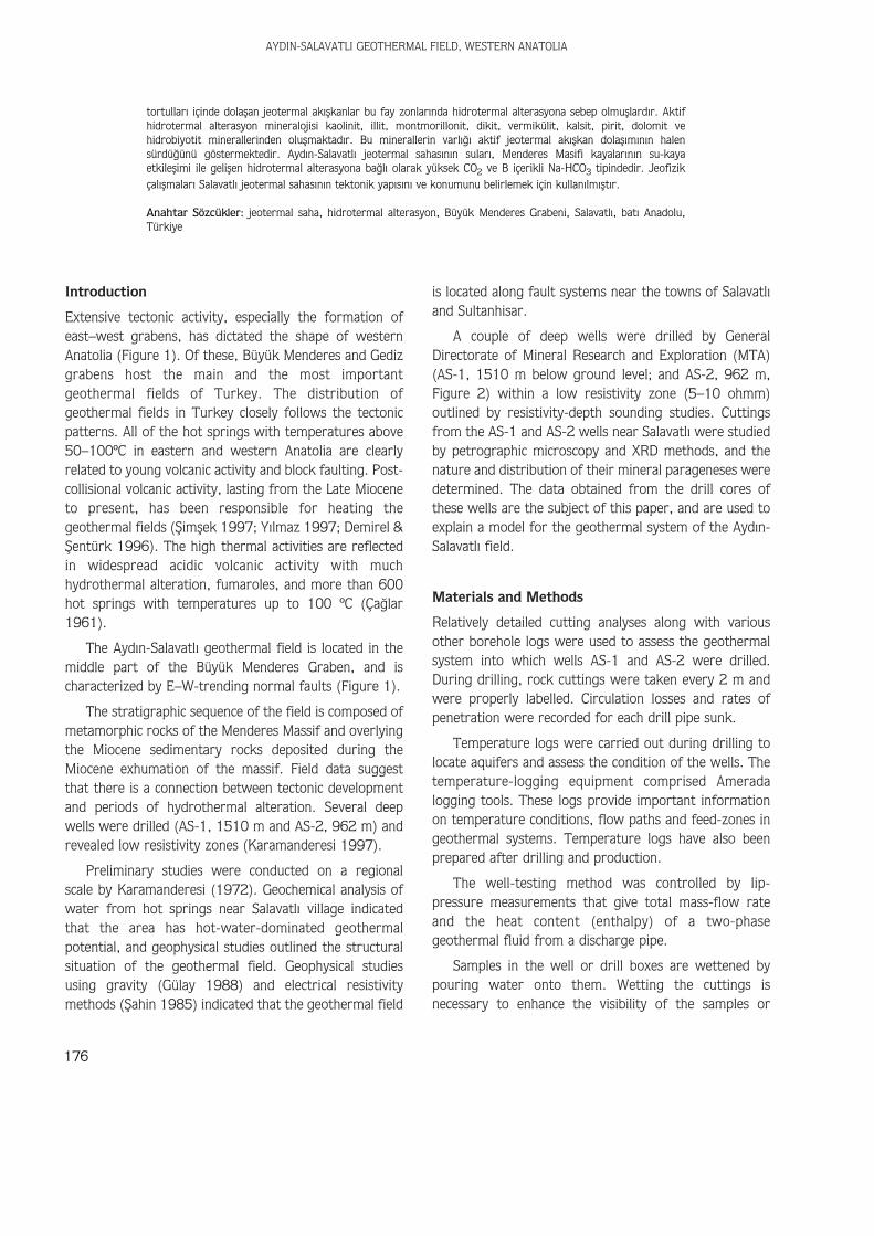
Extensive tectonic activity, especially the formation ofeast–west grabens, has dictated the shape of westernAnatolia (Figure 1). Of these, Büyük Menderes and Gedizgrabens host the main and the most importantgeothermal fields of Turkey. The distribution ofgeothermal fields in Turkey closely follows the tectonicpatterns. All of the hot springs with temperatures above50–100ºC in eastern and western Anatolia are clearlyrelated to young volcanic activity and block faulting. Post-collisional volcanic activity, lasting from the Late Mioceneto present, has been responsible for heating thegeothermal fields (fiimflek 1997; Y›lmaz 1997; Demirel &fientürk 1996). The high thermal activities are reflectedin widespread acidic volcanic activity with muchhydrothermal alteration, fumaroles, and more than 600hot springs with temperatures up to 100 ºC (Ça¤lar1961).
The Ayd›n-Salavatl› geothermal field is located in themiddle part of the Büyük Menderes Graben, and ischaracterized by E–W-trending normal faults (Figure 1).
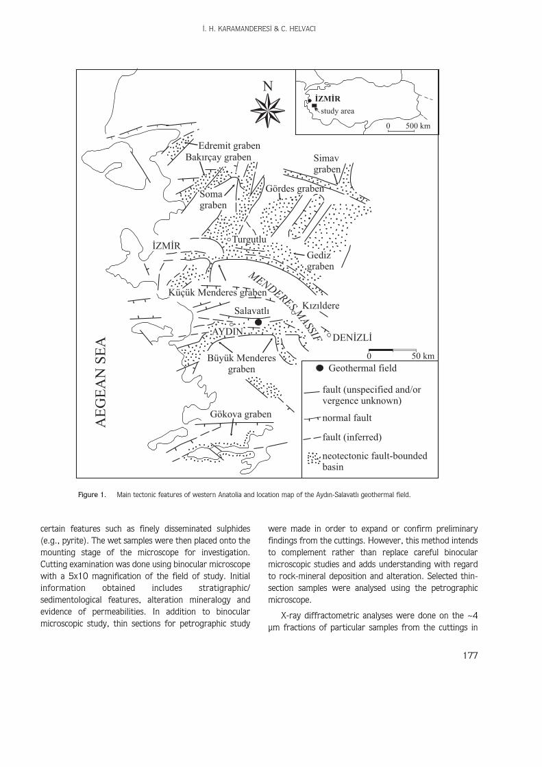
The stratigraphic sequence of the field is composed ofmetamorphic rocks of the Menderes Massif and overlyingthe Miocene sedimentary rocks deposited during theMiocene exhumation of the massif. Field data suggestthat there is a connection between tectonic developmentand periods of hydrothermal alteration. Several deepwells were drilled (AS-1, 1510 m and AS-2, 962 m) andrevealed low resistivity zones (Karamanderesi 1997).
Preliminary studies were conducted on a regionalscale by Karamanderesi (1972). Geochemical analysis ofwater from hot springs near Salavatl› village indicatedthat the area has hot-water-dominated geothermalpotential, and geophysical studies outlined the structuralsituation of the geothermal field. Geophysical studiesusing gravity (Gülay 1988) and electrical resistivitymethods (fiahin 1985) indicated that the geothermal field
is located along fault systems near the towns of Salavatl›and Sultanhisar.
A couple of deep wells were drilled by GeneralDirectorate of Mineral Research and Exploration (MTA)(AS-1, 1510 m below ground level; and AS-2, 962 m,Figure 2) within a low resistivity zone (5–10 ohmm)outlined by resistivity-depth sounding studies. Cuttingsfrom the AS-1 and AS-2 wells near Salavatl› were studiedby petrographic microscopy and XRD methods, and thenature and distribution of their mineral parageneses weredetermined. The data obtained from the drill cores ofthese wells are the subject of this paper, and are used toexplain a model for the geothermal system of the Ayd›n-Salavatl› field.
Materials and Methods
Relatively detailed cutting analyses along with variousother borehole logs were used to assess the geothermalsystem into which wells AS-1 and AS-2 were drilled.During drilling, rock cuttings were taken every 2 m andwere properly labelled. Circulation losses and rates ofpenetration were recorded for each drill pipe sunk.
Temperature logs were carried out during drilling tolocate aquifers and assess the condition of the wells. Thetemperature-logging equipment comprised Ameradalogging tools. These logs provide important informationon temperature conditions, flow paths and feed-zones ingeothermal systems. Temperature logs have also beenprepared after drilling and production.
The well-testing method was controlled by lip-pressure measurements that give total mass-flow rateand the heat content (enthalpy) of a two-phasegeothermal fluid from a discharge pipe.
Samples in the well or drill boxes are wettened bypouring water onto them. Wetting the cuttings isnecessary to enhance the visibility of the samples or
AYDIN-SALAVATLI GEOTHERMAL FIELD, WESTERN ANATOLIA
176
tortullar› içinde dolaflan jeotermal ak›flkanlar bu fay zonlar›nda hidrotermal alterasyona sebep olmufllard›r. Aktifhidrotermal alterasyon mineralojisi kaolinit, illit, montmorillonit, dikit, vermikülit, kalsit, pirit, dolomit vehidrobiyotit minerallerinden oluflmaktad›r. Bu minerallerin varl›¤› aktif jeotermal ak›flkan dolafl›m›n›n halensürdü¤ünü göstermektedir. Ayd›n-Salavatl› jeotermal sahas›n›n sular›, Menderes Masifi kayalar›n›n su-kayaetkileflimi ile geliflen hidrotermal alterasyona ba¤l› olarak yüksek CO2 ve B içerikli Na-HCO3 tipindedir. Jeofizikçal›flmalar› Salavatl› jeotermal sahas›n›n tektonik yap›s›n› ve konumunu belirlemek için kullan›lm›flt›r.
Anahtar Sözcükler: jeotermal saha, hidrotermal alterasyon, Büyük Menderes Grabeni, Salavatl›, bat› Anadolu,Türkiye
‹. H. KARAMANDERES‹ & C. HELVACI
177
certain features such as finely disseminated sulphides(e.g., pyrite). The wet samples were then placed onto themounting stage of the microscope for investigation.Cutting examination was done using binocular microscopewith a 5x10 magnification of the field of study. Initialinformation obtained includes stratigraphic/sedimentological features, alteration mineralogy andevidence of permeabilities. In addition to binocularmicroscopic study, thin sections for petrographic study
were made in order to expand or confirm preliminaryfindings from the cuttings. However, this method intendsto complement rather than replace careful binocularmicroscopic studies and adds understanding with regardto rock-mineral deposition and alteration. Selected thin-section samples were analysed using the petrographicmicroscope.
X-ray diffractometric analyses were done on the ~4µm fractions of particular samples from the cuttings in
NÝZMÝR
study area
Simavgraben
0 50 km
500 km0
Gördes graben
Turgutlu
Somagraben
Bakýrçay grabenEdremit graben
Gedizgraben
Kýzýldere
Geothermal field
fault (unspecified and/orvergence unknown)
normal fault
fault (inferred)
neotectonic fault-boundedbasin
Salavatlý
Büyük Menderesgraben
Küçük Menderes graben
Gökova graben
AYDIN
ÝZMÝR
AE
GE
AN
SE
A DENÝZLÝ
MEN
DERES
MASSIF
Figure 1. Main tectonic features of western Anatolia and location map of the Ayd›n-Salavatl› geothermal field.
AYDIN-SALAVATLI GEOTHERMAL FIELD, WESTERN ANATOLIA
178
Ovacýk Plateau
DEMÝRHAN
MALGAÇEMÝR
SALAVATLI
Bozköy overthrust
B. Menderes River
Q
Q
Kab
aklýd
ere
09
0 1 2 km
N
Q
A
A
Kara T.
AZAPDERESÝ
Q
AS-1
AS-2
YAVUZKÖY
KÖÞK
1680 20
40
10
86
SULTANHÝSAR
YENÝPAZAR
contactaugen gneissalluvium - travertine -terrace materials
clay - marl -sandstoneclay - marl -sandstone
quartz vein
gabbro
PRE
-MIO
CE
NE
.
PAL
EO
ZO
IC
MIO
C.
PLIO
.Q
UA
.
garnet-amphiboleschist
Demirhanmetagranite
chlorite schist
marble
Bozköy overthrust
Bozdað overthrust
fault
thrust orreverse faultcross-section
deep well
thermal spring
fumarole
Geo
elec
tric
prof
illin
e
ATÇA
Hamam(mevkii)
A
AS-1
A
ESKÝHÝSAR
GÜVENDÝK
Q Bey Daðý
OverthrustBozdað
Figure 2. Geological map of the Ayd›n-Salvatl› geothermal field.
order to confirm and identify the types of clay mineralspresent in the cuttings. Approximately two teaspoons ofdrill cuttings were placed into a test tube, and dust waswashed out with distilled water. The tubes were filled 2/3full with distilled water and plugged with rubberstoppers. The tubes were placed in a mechanical shakerfor 4–8 hours, depending on the alteration grade of thesamples. The contents were allowed to settle for 1–2hours until only particles finer than approximately 4microns were left in suspension. A few millilitres of liquidwas pipetted from each tube and about 10 drops placedon a labelled glass plate. An effort was made to avoidthick samples. A duplicate was made of each sample andleft to dry at room temperature overnight. One set ofsamples was placed in a desiccator containing glycol(C2O6O2) solution and the other into a desiccatorcontaining CaCl22H2O. The samples were stored at roomtemperature for at least 24 hours. Thick samples neededa longer time in the desiccator – at least 48 hours. Bothsets of samples were run from 2 to 15° on the XRD. Oneset of the samples (normally the glycolated one) wasplaced on an asbestos plate and heated in a preheatedoven at 550–600 °C. The oven temperature did notexceed 600 °C. The exact location on the asbestos ofindividual samples was established before heating becauselabelling disappears during the heating process. Thesamples were cooled sufficiently before furthertreatment. Then the samples were run from 2 to 15° onthe XRD.
Geologic Setting of the Menderes Massif
The Menderes Massif is a crustal-scale (covering morethan 40,000 km2), elongate (with its long axis trendingNE–SW) metamorphic core complex in western Turkey(Figure 1). It is structurally overlain by the Lycian Nappes(e.g., Graciansky 1972; Collins & Robertson 1997,1999; Oberhänsli et al. 2001) in the south and rocks ofthe ‹zmir-Ankara Neotethyan suture (e.g., fiengör &Y›lmaz 1981; Okay & Siyako 1993; Okay et al. 1996a) inthe north. There are claims that the massif can becorrelated with the Cycladic Massif in the Aegean (Dürr etal. 1978; Oberhänsli et al. 1998); but others argue thatthese massifs do not represent mutually lateralcontinuations (e.g., Ring et al. 1999; Okay 2001).
The massif forms one of the most importantgeological entities of the Turkish Alpine orogenic belt in
western Turkey, and has been under the influence of N–Scrustal extensional tectonics since the Early Miocene (e.g.,Koçyi¤it et al. 1999; Bozkurt 2001a, b; Bozkurt &Oberhänsli 2001a, b; Seyito¤lu et al. 2002; Sözbilir2002). It is dissected into northern, central and southernsubmassifs along the E–W-trending seismically activeGediz and Büyük Menderes grabens, respectively; thegrabens are the result of N–S extension whichcommenced by the Early Pliocene (~5 Ma) (e.g., Koçyi¤itet al. 1999; Bozkurt 2000, 2001a, 2002; Sar›ca 2000;Y›lmaz et al. 2000; Genç et al. 2001; Gürer et al. 2001;Sözbilir 2001, 2002; Y›lmaz & Karac›k 2001). It is nowagreed that each submassif represents a core complexformation in the footwall of presently low-angle normalfaults, but their exhumations have occurred at differenttimes (e.g., Bozkurt & Park 1994, 1997a, b; Verge1995; Hetzel et al. 1995a, b, 1998; Okay et al. 1996b;Koçyi¤it et al. 1999; Bozkurt & Sat›r 2000; Bozkurt2001b; Gessner et al. 2001a, b; Gökten et al. 2001; Ifl›k& Tekeli 2001; Sözbilir 2001).
The Menderes Massif is traditionally described as athick lithologic succession made up of: (1) a ‘core’consisting mostly of granitic augen gneiss withboundinaged layers of metagabbros – they showgranulite and eclogite relics and, (2) a ‘cover’ series oflow-grade metasediments comprising metapelites withsubordinate psammite, amphibolite and marbleintercalations (Palaeozoic ‘schist cover’) and a marble-dominated sequence (Mesozoic-Cenozoic ‘marble cover’)containing emery, metabauxite, and rudist fossils. Theage of the granitic protolith for the augen gneisses isassigned as Late Precambrian and Early Cambrian (c.521–572 Ma, averaging 550 Ma: U-Pb and Pb-Pb singlezircon evaporation methods) (e.g., Hetzel & Reischmann1996; Loos & Reischmann 1999; Gessner et al. 2001a).Fossil evidence indicates a Permian to Middle Palaeoceneage for the cover rocks (e.g., Phillipson 1918; Önay1949; Ça¤layan et al. 1980; Konak et al. 1987). Thereaders are referred to Okay (2001, 2002), Özer et al.(2001) and Güngör & Erdo¤an (2002) for furtherreading.
The contact relationship between the so-called ‘core’and ‘cover’ rocks is still debated. The views fall into threemajor categories: (1) the contact is a major unconformitycalled the supra Pan-African unconformity (fiengör et al.1984); (2) it is a south-facing extensional shear zone withpreserved local igneous contacts along which the corerocks are intrusive into cover rocks (Bozkurt et al. 1993,
‹. H. KARAMANDERES‹ & C. HELVACI
179
1995; Bozkurt & Park 1994, 1997a, b, 1999; Hetzel &Reischmann 1996; Bozkurt & Sat›r 2000; Lips et al.2001). These authors suggest that the so-called corerocks have been exhumed in the footwall of this shearzone during a top-to-the-SSW deformation; (3) whileothers confirm the tectonic nature of this contact butclaim that it is south-facing thrust fault with a top-to-the-south deformation (Ring et al. 1999; Gessner et al.2001a).
The literature suggests that the core rocks have beenaffected by granulite facies metamorphism followed by aneclogite facies event, then by an amphibolite faciesmetamorphic overprint (Candan 1995, 1996; Candan etal. 1997, 2001; Oberhänsli et al. 1997; Candan & Dora1998). The lack of eclogite and granulite relicts in theaugen gneisses suggests that these rocks were affectedonly by the latest amphibolite-facies metamorphism (e.g.,Candan et al. 2001 and references therein).
The most agreed-upon concept concerning theMenderes Massif is that the massif has acquired its massifcharacter during an Alpine regional HT/MP Barrovian-type tectono-metamorphic event termed “main Menderesmetamorphism (MMM)” during Eocene (Rb-Sr mica agesof 35±5 Ma, Sat›r & Friedrichsen 1986 and 62–43 Ma,Bozkurt & Sat›r 2000; 40Ar-39Ar mica age of 43–37 Ma,Hetzel & Reischmann 1996; and 40Ar-39Ar laser probemica age of 36±2, Lips et al. 2001). It is suggested thatthe MMM was a result of the burial of the massif areabeneath the southward moving Lycian nappes – rootedfrom the ‹zmir-Ankara Neotethyan suture zone, thuscausing regional metamorphism and deformation of themassif (fiengör & Y›lmaz 1981; fiengör et al. 1984). Onthe other hand, the existing structures formed during theMMM indicate a top-to-the-NNE tectonic transport(Bozkurt 1995; Hetzel et al. 1998; Bozkurt & Park1999; Bozkurt 2001b; Bozkurt & Oberhänsli 2001a).Temperatures during the ‘MMM’ reached ~550 °C whilepressure is estimated as ≤5 kbar (Whitney & Bozkurt2002). Subsequent exhumation occurred along originallyhigh-angle but presently low-angle normal faults duringMiocene time (e.g., Bozkurt & Park 1994, 1997a, b;Hetzel et al. 1995a, b, 1998; Verge 1995; Hetzel &Reischmann 1996; Koçyi¤it et al. 1999; Bozkurt 2000,2001a, b; Gessner et al. 2001a, b; Gökten et al. 2001;Ifl›k & Tekeli 2001; Lips et al. 2001; Bozkurt &Oberhänsli 2001a; Sözbilir 2001, 2002; Seyito¤lu et al.2002).
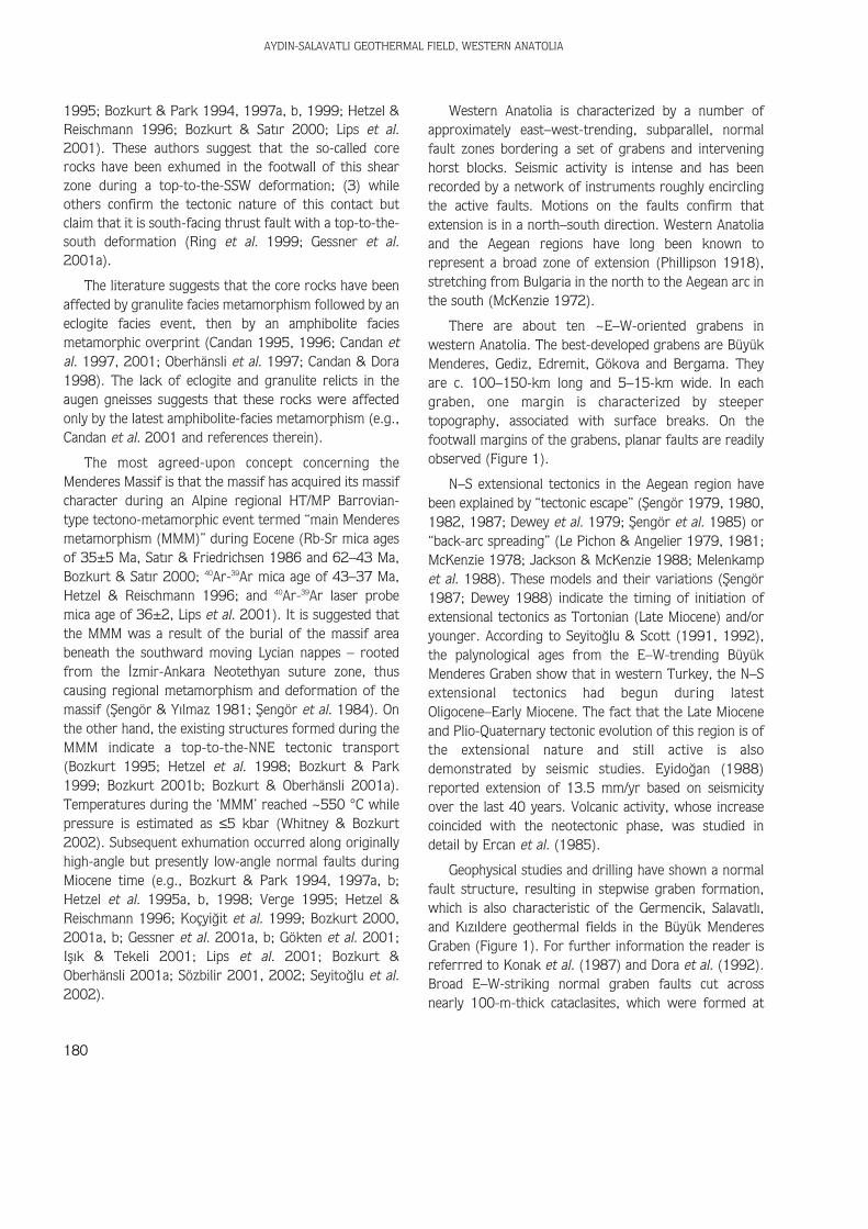
Western Anatolia is characterized by a number ofapproximately east–west-trending, subparallel, normalfault zones bordering a set of grabens and interveninghorst blocks. Seismic activity is intense and has beenrecorded by a network of instruments roughly encirclingthe active faults. Motions on the faults confirm thatextension is in a north–south direction. Western Anatoliaand the Aegean regions have long been known torepresent a broad zone of extension (Phillipson 1918),stretching from Bulgaria in the north to the Aegean arc inthe south (McKenzie 1972).
There are about ten ~E–W-oriented grabens inwestern Anatolia. The best-developed grabens are BüyükMenderes, Gediz, Edremit, Gökova and Bergama. Theyare c. 100–150-km long and 5–15-km wide. In eachgraben, one margin is characterized by steepertopography, associated with surface breaks. On thefootwall margins of the grabens, planar faults are readilyobserved (Figure 1).
N–S extensional tectonics in the Aegean region havebeen explained by “tectonic escape” (fiengör 1979, 1980,1982, 1987; Dewey et al. 1979; fiengör et al. 1985) or“back-arc spreading” (Le Pichon & Angelier 1979, 1981;McKenzie 1978; Jackson & McKenzie 1988; Melenkampet al. 1988). These models and their variations (fiengör1987; Dewey 1988) indicate the timing of initiation ofextensional tectonics as Tortonian (Late Miocene) and/oryounger. According to Seyito¤lu & Scott (1991, 1992),the palynological ages from the E–W-trending BüyükMenderes Graben show that in western Turkey, the N–Sextensional tectonics had begun during latestOligocene–Early Miocene. The fact that the Late Mioceneand Plio-Quaternary tectonic evolution of this region is ofthe extensional nature and still active is alsodemonstrated by seismic studies. Eyido¤an (1988)reported extension of 13.5 mm/yr based on seismicityover the last 40 years. Volcanic activity, whose increasecoincided with the neotectonic phase, was studied indetail by Ercan et al. (1985).
Geophysical studies and drilling have shown a normalfault structure, resulting in stepwise graben formation,which is also characteristic of the Germencik, Salavatl›,and K›z›ldere geothermal fields in the Büyük MenderesGraben (Figure 1). For further information the reader isreferrred to Konak et al. (1987) and Dora et al. (1992).Broad E–W-striking normal graben faults cut acrossnearly 100-m-thick cataclasites, which were formed at
AYDIN-SALAVATLI GEOTHERMAL FIELD, WESTERN ANATOLIA
180
the base of detachment faults, and non-metamorphicNeogene sediments on the crystalline basement (Hetzel etal. 1995b). Several intermediate to basic volcanicextrusions and geothermal springs in the central parts ofthe Menderes Massif are directly related to the grabensystem. Early fossil geothermal systems developed alongtectonic zones during the dome-forming period. Thedevelopment and evolution of these systems are relatedto neotectonic activity (Figure 2).
Although the Menderes Massif has been the subject ofintense research since 1990s there are still manyproblems concerning the lithology, age, structure,deformation and metamorphism of the Menderes Massif.We therefore suggest that readers refer to Bozkurt &Oberhänsli (2001a, b) for further reading.
Geology of the Ayd›n-Salavatl› Area
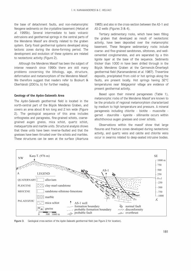
The Ayd›n-Salavatl› geothermal field is located in thenorth-central part of the Büyük Menderes Graben, andcovers an area about 8 km long and 2 km wide (Figure2). The geological sequence of this area includesorthogneiss and paragneiss, fine-grained schists, coarse-grained augen gneiss, mica schist, quartz schist,metaquartzite and marble units. Structural analysis showsthat these units have been reverse-faulted and that thegneisses have been thrusted over the schists and marbles.These structures can be seen at the surface (Akartuna
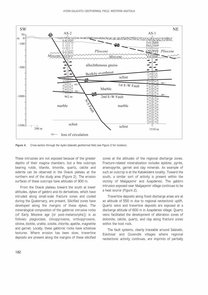
1965) and also in the cross-section between the AS-1 andAS-2 wells (Figures 3 & 4).
Tertiary sedimentary rocks, which have been fillingthe graben that developed as result of neotectonicactivity, have been deposited over the metamorphicbasement. These Neogene sedimentary rocks includecoarse- and fine-grained sandstones, siltstones, and well-cemented conglomerates, and are separated by a thinlignite layer at the base of the sequence. Sedimentsthicker than 1000 m have been drilled through in theBüyük Menderes Graben at the Germencik-Ömerbeyligeothermal field (Karamanderesi et al. 1987). Travertinedeposits, precipitated from cold or hot springs along thefaults, are present locally. Hot springs having 32°Ctemperatures near Malgaçemir village are evidence ofpresent geothermal activity.
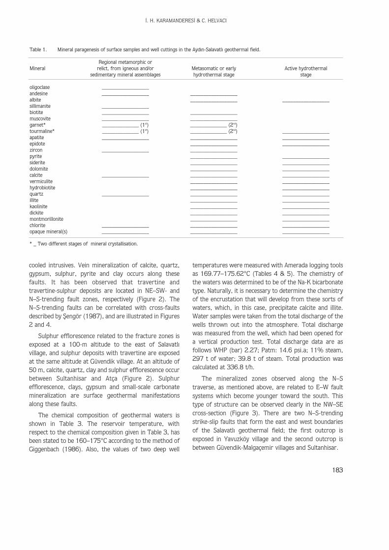
Based upon their mineral parageneses (Table 1),metamorphic rocks of the Menderes Massif are known tobe the products of regional metamorphism characterizedby medium to high temperature and pressure. A mineralparagenesis including chlorite - biotite - muscovite -garnet - staurolite - kyanite - sillimanite occurs withinallochthonous augen gneisses and cover schists.
Observations within the massif show that largefissures and fracture zones developed during neotectonicactivity, and quartz veins and calcite and chlorite veinsoccur in swarms related to deep-seated intrusive bodies.
‹. H. KARAMANDERES‹ & C. HELVACI
181
C
1000 m
750
500
250
0 s.l
-250
-500
-750
-1000F1 F2 F3
F4
normal faultformation boundaryAS-1 well
probable formation boundaryprobable fault
disconformityoverthrust
SENW
Kara T. (976 m)
AS-1
A
A
alluviumQUATERNARY
LEGEND
clay-marl-sandstonePLIOCENE
sandstone-siltstone-limestoneMIOCENE
PALAEOZOIC
marble
mica schist
gneiss
0 500 1000 m
Figure 3. Geological cross-section of the Ayd›n-Salavatl› geothermal field (see Figure 2 for location).
These intrusives are not exposed because of the greaterdepths of their magma chambers, but a few outcropsbearing rutile, titanite, limonite, quartz, calcite andsiderite can be observed in the Ovac›k plateau at thenorthern end of the study area (Figure 2). The erosionsurfaces of these outcrops have altitudes of 900 m.
From the Ovac›k plateau toward the south at loweraltitudes, dykes of gabbro and its derivatives, which haveintruded along small-scale fracture zones and cooledduring the Quaternary, are present. Silicified zones havedeveloped along the margins of these dykes. Themineralogical composition of the gabbroic intrusive rocks(of Early Miocene age [or post-metamorphic]) is asfollows: plagioclase, clinopyroxene, orthopyroxene,olivine, biotite, uralite, zoisite, chlorite, apatite, magnetiteand garnet. Locally, these gabbroic rocks have schistosetextures. Where erosion has been slow, travertinedeposits are present along the margins of these silicified
zones at the altitudes of the regional discharge zones.Fracture-related mineralization includes epidote, pyrite,arsenopyrite, garnet and clay minerals. An example ofsuch an outcrop is at the Kabakl›dere locality. Toward thesouth, a similar sort of activity is present within thevicinity of Malgaçemir and Azapderesi. The gabbrointrusion exposed near Malgaçemir village continues to bea heat source (Figure 2).
Travertine deposits along fossil discharge areas are atan altitude of 550 m due to regional neotectonic uplift.Quartz veins and travertine deposits are exposed at adischarge altitude of 600 m in Azapderesi village. Quartzveins facilitated the development of alteration zones ofdolomite, calcite, quartz, and clay along fracture zoneswithin the host rock.
The fault systems, clearly traceable around Salavatl›,Eskihisar and Güvendik villages where regionalneotectonic activity continues, are imprints of partially
AYDIN-SALAVATLI GEOTHERMAL FIELD, WESTERN ANATOLIA
182
AS-2SW NE
AS-1
PliocenePliocene
MioceneMiocene
allochthonous gneiss
schist
schistschist
Marble1st E-W Fault
2nd E-W Fault
N-S
Fault
marble
loss of circulation
marble
962 m
1510 m200 m-1500
-1000
-500
-100
500m
Bozköy overthrust
Figure 4. Cross-section through the Ayd›n-Salavatl› geothermal field (see Figure 2 for location).
cooled intrusives. Vein mineralization of calcite, quartz,gypsum, sulphur, pyrite and clay occurs along thesefaults. It has been observed that travertine andtravertine-sulphur deposits are located in NE–SW- andN–S-trending fault zones, respectively (Figure 2). TheN–S-trending faults can be correlated with cross-faultsdescribed by fiengör (1987), and are illustrated in Figures2 and 4.
Sulphur efflorescence related to the fracture zones isexposed at a 100-m altitude to the east of Salavatl›village, and sulphur deposits with travertine are exposedat the same altitude at Güvendik village. At an altitude of50 m, calcite, quartz, clay and sulphur efflorescence occurbetween Sultanhisar and Atça (Figure 2). Sulphurefflorescence, clays, gypsum and small-scale carbonatemineralization are surface geothermal manifestationsalong these faults.
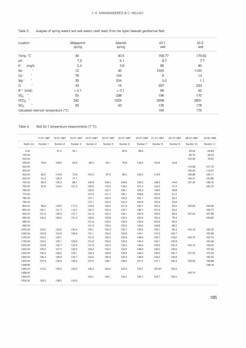
The chemical composition of geothermal waters isshown in Table 3. The reservoir temperature, withrespect to the chemical composition given in Table 3, hasbeen stated to be 160–175°C according to the method ofGiggenbach (1986). Also, the values of two deep well
temperatures were measured with Amerada logging toolsas 169.77–175.62°C (Tables 4 & 5). The chemistry ofthe waters was determined to be of the Na-K bicarbonatetype. Naturally, it is necessary to determine the chemistryof the encrustation that will develop from these sorts ofwaters, which, in this case, precipitate calcite and illite.Water samples were taken from the total discharge of thewells thrown out into the atmosphere. Total dischargewas measured from the well, which had been opened fora vertical production test. Total discharge data are asfollows WHP (bar) 2.27; Patm: 14.6 psi.a; 11% steam,297 t of water; 39.8 t of steam. Total production wascalculated at 336.8 t/h.
The mineralized zones observed along the N–Straverse, as mentioned above, are related to E–W faultsystems which become younger toward the south. Thistype of structure can be observed clearly in the NW–SEcross-section (Figure 3). There are two N–S-trendingstrike-slip faults that form the east and west boundariesof the Salavatl› geothermal field; the first outcrop isexposed in Yavuzköy village and the second outcrop isbetween Güvendik-Malgaçemir villages and Sultanhisar.
‹. H. KARAMANDERES‹ & C. HELVACI
183
Table 1. Mineral paragenesis of surface samples and well cuttings in the Ayd›n-Salavatl› geothermal field.
Regional metamorphic orMineral relict, from igneous and/or Metasomatic or early Active hydrothermal
sedimentary mineral assemblages hydrothermal stage stage
oligoclase __________________andesine __________________ __________________albite __________________ __________________sillimanite __________________biotite __________________ __________________muscovite __________________ __________________garnet* ______________ (1st) ______________ (2nd)tourmaline* ______________ (1st) ______________ (2nd) __________________apatite __________________ __________________ __________________epidote __________________ __________________zircon __________________ __________________pyrite __________________ __________________siderite __________________ __________________dolomite __________________ __________________calcite __________________ __________________ __________________vermiculite __________________ __________________hydrobiotite __________________ __________________quartz __________________ __________________ __________________illite __________________ __________________kaolinite __________________ __________________dickite __________________ __________________montmorillonite __________________ __________________chlorite __________________ __________________ __________________opaque mineral(s) __________________ __________________ __________________
* _ Two different stages of mineral crystallisation.
AYDIN-SALAVATLI GEOTHERMAL FIELD, WESTERN ANATOLIA
184
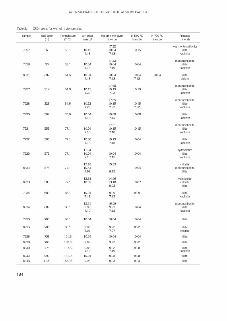
Table 2. XRD results for well AS-1 clay samples.
Sample Well depth Temperature Air-dried Mg-ethylene glycol K-550 °C K-700 °C Probable(m) (T °C) lines dÅ lines dÅ lines dÅ lines dÅ minerals
17.32 less montmorillonite7657 6 52.1 10.15 10.04 10.15 illite
7.18 7.13 kaolinite
17.32 montmorillonite7658 50 52.1 10.04 10.04 10.04 illite
7.13 7.19 kaolinite
8231 287 64.6 10.04 10.04 10.04 10.04 illite7.13 7.13 7.13 dickite
17.65 montmorillonite7927 312 64.6 10.15 10.15 10.15 illite
7.22 7.22 kaolinite
17.65 montmorillonite7928 328 64.6 10.22 10.15 10.15 illite
7.22 7.22 7.22 kaolinite
7930 502 70.9 10.04 10.08 10.08 illite7.13 7.15 kaolinite
17.51 montmorillonite7931 556 77.1 10.04 10.15 10.15 illite
7.13 7.18 kaolinite
7932 566 77.1 10.08 10.15 10.04 illite7.18 7.18 kaolinite
11.04 hydrobiotite7933 576 77.1 10.04 10.04 10.04 illite
7.15 7.13 kaolinite
13.18 15.23 chlorite8232 576 77.1 10.64 10.04 montmorillonite
9.92 9.82 illite
13.38 14.96 vermiculite8233 583 77.1 10.59 13.18 10.07 chlorite
9.93 illite
7934 682 88.1 10.04 9.99 9.99 illite7.18 7.13 kaolinite
12.61 16.99 montmorillonite8234 682 88.1 9.98 9.93 10.04 illite
7.10 7.13 kaolinite
7935 706 88.1 10.04 10.04 10.04 illite
8235 706 88.1 9.92 9.92 9.92 illite7.07 7.07 chlorite
7938 732 101.3 10.04 10.04 10.04 illite
8239 766 122.6 9.92 9.92 9.92 illite
8240 778 127.6 9.86 9.92 9.98 illite7.13 7.19 kaolinite
8242 990 131.9 10.04 9.98 9.98 illite
8243 1100 162.75 9.92 9.93 9.93 illite
‹. H. KARAMANDERES‹ & C. HELVACI
185
Table 3. Analyses of spring waters and well waters (well head) from the Ayd›n-Salavatl› geothermal field.
Location Malgaçemir Salavatl› AS-1 AS-2spring spring well well
Temp. °C 30 40.5 169.77 175.62
pH 7.3 6.1 8.7 7.7
K+ (mg/l) 2.4 3.6 85 90
Na+ " 12 45 1500 1100
Ca++ " 76 104 6 14
Mg++ " 35 204 0.0 1.1
Cl ¯ " 43 16 297 233
B+++ (total) < 0.1 < 0.1 66 42
SO4¯ ¯ " 50 298 196 170
HCO3¯ " 342 1025 3208 2831
SiO2 " 25 43 135 178
Calculated reservoir temperature (°C) 160 175
Table 4. Well AS-1 temperature measurements (T °C).
17.07.1987 19.07.1987 19.07.1987 19.07.1987 20.07.1987 20.07.1987 20.07.1987 21.07.1987 22.07.1987 28.07.1987 16.09.1996
Depth (m) Number 1 Number 2 Number 3 Number 4 Number 5 Number 6 Number 7 Number 8 Number 9 Number 10 Number 11
0.00 91.0 52.1 60.9 58.6 53.04 24.83
100.00 84.73 44.03
200.00 100.46 76.62
250.00 70.8 108.6 64.6 83.0 60.1 79.8 143.5 100.6 42.8
300.00 119.28 101.72
400.00 130.22 119.97
500.00 82.0 119.9 70.9 100.0 87.5 92.0 152.0 119.5 136.68 126.11
600.00 91.5 126.3 77.1 146.41 150.86
700.00 96.3 132.9 88.1 109.9 106.4 109.8 156.5 138.2 44.6 157.34 158.75
750.00 97.8 144.2 101.3 132.6 116.0 118.0 157.4 144.2 47.3 165.70
760.00 122.6 122.7 126.1 158.3 148.6 48.8
770.00 127.6 131.1 135.1 159.8 152.6 51.2
780.00 137.1 143.4 145.5 162.1 160.6 52.2
790.00 137.1 142.2 144.3 160.8 160.6 53.8
800.00 99.9 143.5 117.4 134.9 139.4 141.9 159.7 160.2 59.0 163.90 169.46
850.00 100.1 131.7 119.7 125.7 130.4 133.7 158.7 157.5 64.2 169.77
900.00 101.9 128.4 131.7 131.9 132.4 133.1 160.6 156.0 68.9 167.00 167.58
950.00 102.2 126.2 131.0 132.6 133.8 134.0 152.6 152.4 75.4 166.80
980.00 131.9 133.2 133.9 149.9 150.6 82.5
990.00 131.9 133.2 133.5 149.6 149.8 86.2
1000.00 103.2 125.5 130.4 132.1 133.3 133.7 149.2 149.1 90.4 165.16 165.33
1050.00 102.8 124.9 129.9 131.1 132.4 132.8 149.1 147.3 102.7 163.56
1100.00 103.2 125.1 131.5 132.3 132.8 148.9 145.7 118.6 162.75 162.70
1150.00 103.2 125.1 129.9 131.6 132.6 132.9 149.4 145.1 132.8 160.48
1200.00 103.8 125.7 130.5 131.8 132.3 133.2 149.6 145.6 145.3 160.10 159.22
1250.00 105.5 127.3 132.0 133.3 134.4 134.5 148.9 146.0 145.6 157.92
1300.00 106.4 128.2 133.1 134.4 135.8 135.8 148.4 145.5 145.7 157.00 157.03
1350.00 106.4 128.4 132.7 134.6 135.9 135.9 148.6 145.2 145.8 156.46
1400.00 107.9 130.9 135.6 137.0 138.1 138.6 151.2 147.1 146.4 155.50 156.88
1438.65 158.18
1450.00 113.2 136.5 140.9 142.3 143.4 143.3 153.7 150.97 150.9
1458.00 155.73
1494.00 144.1 145.1 145.2 155.7 153.7 152.5
1500.00 129.3 138.2 143.0
Evidence of surface mineralization is also present inthe cuttings of the AS-1 and AS-2 wells. Mineral productsof hydrothermal activity (Table 1), including quartz,calcite, dolomite, siderite, pyrite, kaolinite, dickite (seenat 378 m within Miocene sandstone of AS-1 borehole, asan acidic alteration), montmorillonite, illite, (seen abovethe lost circulation zone as the product of scaling and caprock in AS-1), hydrobiotite, vermiculite (seen at 583 m inAS-1), sericite, chlorite, albite, limonite, and opaqueminerals, have been noted in the AS-2 and AS-1 wells.
X-ray diffraction analyses were done on selected ≅ 4mm samples of cuttings to identify and confirm the typesof clay minerals present in the cuttings. Especially detailedstudy was done on well number AS-1. Relevant data aregiven in Table 2.
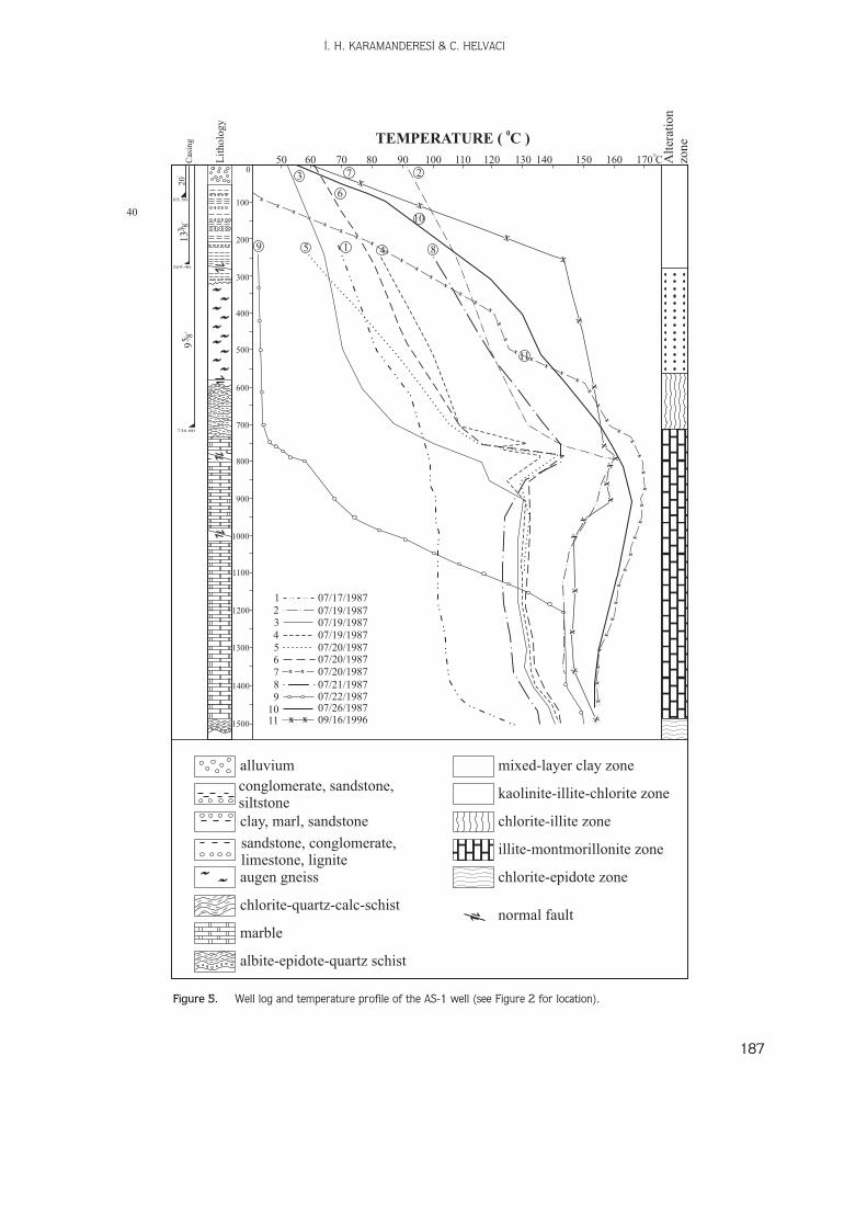
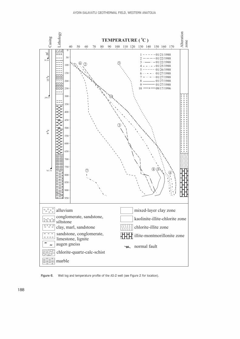
XRD analyses for clay minerals were done on samplestaken from several depths in the AS-1 and AS-2 wells,and indicate the presence of montmorillonite, illite,chlorite, vermiculite, hydrobitite and dickite. Figures 5and 6 show two well sections with five different clayzones distinguished. From top to bottom they are asfollows: a mixed-layer clay zone, an illite-kaolinite zone, achlorite-illite zone, an illite-montmorillonite zone and achlorite-epidote zone.
Albitization and chloritization in the metamorphicsequences of AS-1 and particularly in AS-2 were clearlyobserved. Miocene sediments in the same wells showacidic alteration such as dickite. Vermiculite, observed atthe base of the gneisses, indicates the presence of anearby intrusive body which apparently intruded the floor
AYDIN-SALAVATLI GEOTHERMAL FIELD, WESTERN ANATOLIA
186
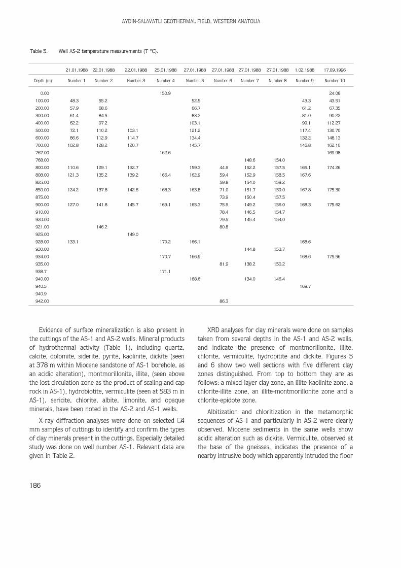
Table 5. Well AS-2 temperature measurements (T °C).
21.01.1988 22.01.1988 22.01.1988 25.01.1988 27.01.1988 27.01.1988 27.01.1988 27.01.1988 1.02.1988 17.09.1996
Depth (m) Number 1 Number 2 Number 3 Number 4 Number 5 Number 6 Number 7 Number 8 Number 9 Number 10
0.00 150.9 24.08
100.00 48.3 55.2 52.5 43.3 43.51
200.00 57.9 68.6 66.7 61.2 67.35
300.00 61.4 84.5 83.2 81.0 90.22
400.00 62.2 97.2 103.1 99.1 112.27
500.00 72.1 110.2 103.1 121.2 117.4 130.70
600.00 86.6 112.9 114.7 134.4 132.2 148.13
700.00 102.8 128.2 120.7 145.7 146.8 162.10
767.00 162.6 169.98
768.00 148.6 154.0
800.00 110.6 129.1 132.7 159.3 44.9 152.2 157.5 165.1 174.26
808.00 121.3 135.2 139.2 166.4 162.9 59.4 152.9 158.5 167.6
825.00 59.8 154.0 159.2
850.00 124.2 137.8 142.6 168.3 163.8 71.0 151.7 159.0 167.8 175.30
875.00 73.9 150.4 157.5
900.00 127.0 141.8 145.7 169.1 165.3 75.9 149.2 156.0 168.3 175.62
910.00 78.4 146.5 154.7
920.00 79.5 145.4 154.0
921.00 146.2 80.8
925.00 149.0
928.00 133.1 170.2 166.1 168.6
930.00 144.8 153.7
934.00 170.7 166.9 168.6 175.56
935.00 81.9 138.2 150.2
938.7 171.1
940.00 168.6 134.0 146.4
940.5 169.7
940.9
942.00 86.3
‹. H. KARAMANDERES‹ & C. HELVACI
187
11
10
4
Alt
erat
ion
zone
736.80
269.46
85.50
Lit
holo
gy
Cas
ing
2013
3 / 89
5 / 8X
X
X
X
X
X
X
X
X
X
X
X
X
X
X
X
XX
X
X
X
X
X
X
X
X
X
X
X
XX
XX
XX
XX
XX
X
X
X X
XX
XX
X
XX
XX
X
XX
X
X
X
X
X
X
X
XX
X X
3
5 1
6
7 2
89
07/17/198707/19/198707/19/198707/19/198707/20/198707/20/198707/20/198707/21/198707/22/198707/26/198709/16/1996
123456789
1011
50 60 70 80 90 100 110 120 130 140 150 160 170 C
TEMPERATURE ( 0C )
40
0
100
200
300
400
500
600
700
800
900
1000
1100
1200
1300
1400
1500
alluvium
conglomerate, sandstone,siltstone
kaolinite-illite-chlorite zone
chlorite-illite zone
illite-montmorillonite zone
chlorite-epidote zone
normal fault
mixed-layer clay zone
clay, marl, sandstone
sandstone, conglomerate,limestone, ligniteaugen gneiss
chlorite-quartz- schistcalc-
marble
albite-epidote-quartz schist
Figure 5. Well log and temperature profile of the AS-1 well (see Figure 2 for location).
AYDIN-SALAVATLI GEOTHERMAL FIELD, WESTERN ANATOLIA
188
X
X X
X
X
X
X
X
X
X
X
X
X
X
X
X
X
X
X
X
X
X
X
X
X
XX
XX
123456789
10
01/21/198801/22/198801/22/198801/25/198801/26/198801/27/198801/27/198801/27/198801/27/198809/17/1996
261 5
10
3
8 94
7
40
50
0
100
150
200
250
300
59.36
299.57
767.78
350
400
450
500
550
600
650
700
750
800
850
900
950
50 60 70 80 90 100 110 120 130 140 150 160 170
alluvium
conglomerate, sandstone,siltstone
kaolinite-illite-chlorite zone
chlorite-illite zone
illite-montmorillonite zone
mixed-layer clay zone
clay, marl, sandstone
sandstone, conglomerate,limestone, ligniteaugen gneiss
marble
Alt
erat
ion
zone
Lit
holo
gy
Cas
ing
2013
3 /8
95 /
8
TEMPERATURE ( 0C )
normal faultchlorite-quartz- schistcalc-
Figure 6. Well log and temperature profile of the AS-2 well (see Figure 2 for location).
of the graben (Boles 1977). Feldspar, garnet, muscovite,biotite, tourmaline, rutile, apatite, graphite, cristobaliteand epidote observed in the same zones are either earlyhigh-temperature products of hydrothermal alteration orrelict minerals from regional metamorphism (Table 1).Albite, chlorite, vermiculite, dickite, quartz, calcite,kaolinite, dolomite, montmorillonite, and illite areproducts of hydrothermal alteration and occur as veinfillings and in vesicules (Table 2). These minerals indicatea temperature range between 150°C and 300°C (Henley& Ellis 1983).
An NE–SW cross-section through the AS-1 and AS-2wells (Figure 4) suggests that the NE–SW fault systemspassing through marble are the production zone forgeothermal fluids in the region. Well-finishing testing wascompleted for the AS-1 well. Eleven temperaturemeasurements were taken during the well testing (Table4). These temperature measurements indicate that thereservoir of this field is a horizontal-flow type locatedwithin the fault zones between 750–780 m and990–1000 m. Temperature measurements are given inFigure 5. A negative thermal gradient was measured at1000 m depth in the AS-1 well. Stefansson &Steingrimsson (1981) showed that there is a negativegradient below the horizontal-flow zone in thehorizontal-flow system.
The AS-2 well was terminated at a depth of 962 mwhere complete loss of circulation was attained. Well-finishing testing was completed for the AS-2 well. Tentemperature measurements were taken during the welltesting (Table 5). These temperature measurementsindicate that the reservoir of this cross-fault zone islocated between 750 and 950 m. The temperaturemeasurements are given in Figure 6. Total discharge dataare as follows: WHP (bar.g) 2; Pc (psig) 11; totalproduction is calculated at 313.2 t/h. WHP (bar.g) is14.5. The maximum temperatures measured in the AS-1and AS-2 wells were 169.77ºC and 175.62ºC,respectively. These maximum temperatures wererecorded between 770 and 990 m in both wells. Belowthis level, the temperature in AS-1 decreased to 155ºC.These temperature data indicate that the fault systemscontrol the geothermal activity in the area, and that themaximum attainable reservoir temperature can be foundto the south where the normal-fault systems are bothyounger and deeper (see Figure 3).
Geophysical Survey
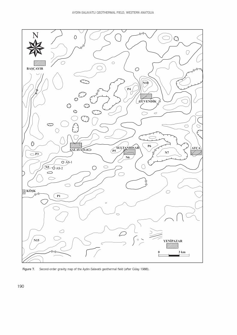
Gravity surveys were used to outline regional tectonicstructures such as the main fault systems along horst andgraben boundaries. Positive anomalies on the second-order derivative gravity map suggest that there arehidden horsts within the graben in the vicinity of Salavatl›,Sultanhisar and Köflk (Gülay 1988) (Figure 7).
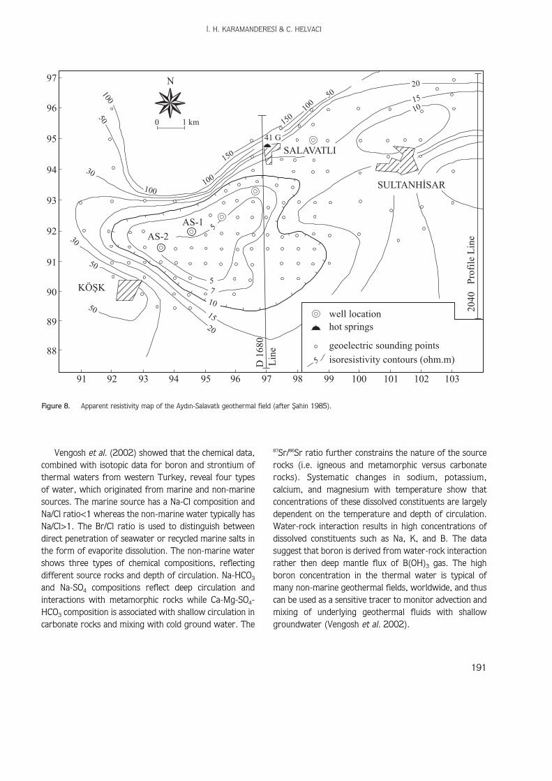
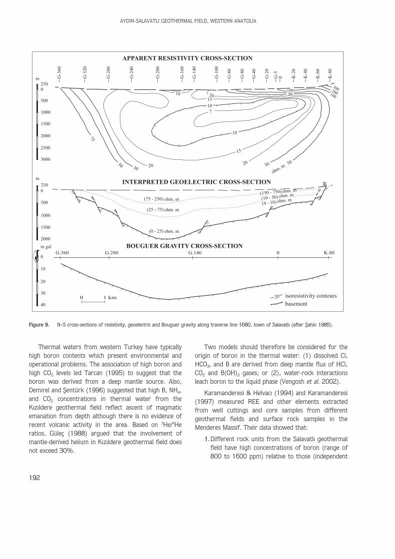
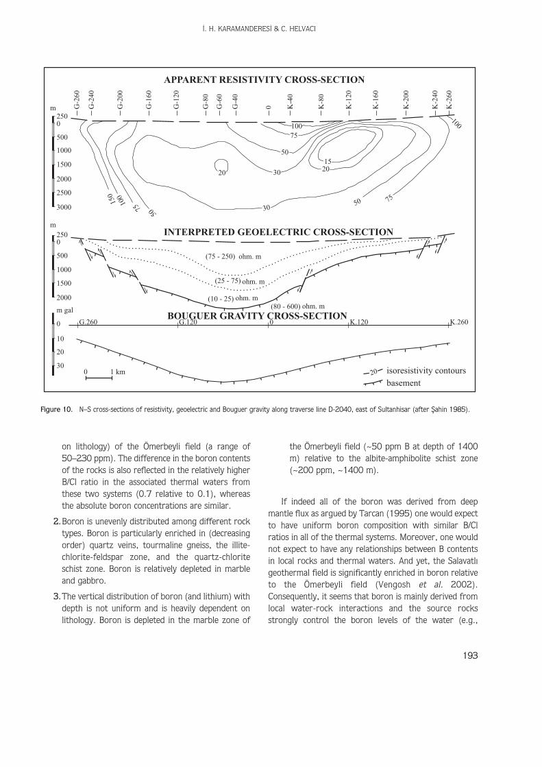
Resistivity surveys were completed to delineate thegeothermal reservoir system by means of its lowresistivity values (Griffiths & King 1969). An apparentresistivity map was plotted with a half electrode distanceof 700 m, which reflects the resistivity features at adepth of 700 m (Figure 8). It should be noted that thereare two distinct resistivity anomaly trends extending fromNE to SW and from NW to SE. These represent thenormal-faulted boundaries of the horst and grabenstructures between Salavatl› and Köflk. The resistivitymap frames a roughly triangular area characterized byvery low resistivity contours (5–10 ohm). Such areas,with resistivity values much lower than the backgroundresistivity, are generally classified as high-potential,geothermal energy target areas in the Büyük MenderesGraben (fiahin 1985).
Geoelectric and Bouguer gravity anomaly cross-sections along traverse lines D-1680 and D-2040(Figures 9 & 10) suggest a structural relationshipbetween the metamorphic basement and the Neogenecover. The lowest resistivity in this area is located on thenorthern flank of the graben above the step-faultedbasement. These lower resistivities apparently resultfrom the circulation of super-heated geothermal fluidalong the heavily fractured active fault zones in thebasement. Deep exploratory drilling to intersect thesesupposed active fault zones at deeper levels is suggestedfor the future assessment of the Ayd›n-Salavatl›geothermal field. It is obvious that more deep drilling isnecessary in order to explain the detailed characteristicsof this field.
Discussion and Conclusion
The thermal systems of western Turkey exhibit a widerange of chemical compositions that reflect the complexnature and different sources of thermal waters. Vengoshet al. (2002) distinguish four major groups that reflectdifferent origins and mechanisms of water-rockinteractions.
‹. H. KARAMANDERES‹ & C. HELVACI
189
AYDIN-SALAVATLI GEOTHERMAL FIELD, WESTERN ANATOLIA
190
YENÝPAZAR
0 3 km
KÖÞK
P5
P6
N6
N7
N10
P4
0+0
0+0
0+0
0+0
0+0
0+0
0+0
0+0
BAÞÇAYIR
ATÇASALAVATLI
AS-2
AS-1
P3
N5
P1
N15
0+0
N
0+0
GÜVENDÝK
SULTANHÝSAR
Figure 7. Second-order gravity map of the Ayd›n-Salavatl› geothermal field (after Gülay 1988).
‹. H. KARAMANDERES‹ & C. HELVACI
191
Vengosh et al. (2002) showed that the chemical data,combined with isotopic data for boron and strontium ofthermal waters from western Turkey, reveal four typesof water, which originated from marine and non-marinesources. The marine source has a Na-Cl composition andNa/Cl ratio<1 whereas the non-marine water typically hasNa/Cl>1. The Br/Cl ratio is used to distinguish betweendirect penetration of seawater or recycled marine salts inthe form of evaporite dissolution. The non-marine watershows three types of chemical compositions, reflectingdifferent source rocks and depth of circulation. Na-HCO3
and Na-SO4 compositions reflect deep circulation andinteractions with metamorphic rocks while Ca-Mg-SO4-HCO3 composition is associated with shallow circulation incarbonate rocks and mixing with cold ground water. The
87Sr/86Sr ratio further constrains the nature of the sourcerocks (i.e. igneous and metamorphic versus carbonaterocks). Systematic changes in sodium, potassium,calcium, and magnesium with temperature show thatconcentrations of these dissolved constituents are largelydependent on the temperature and depth of circulation.Water-rock interaction results in high concentrations ofdissolved constituents such as Na, K, and B. The datasuggest that boron is derived from water-rock interactionrather then deep mantle flux of B(OH)3 gas. The highboron concentration in the thermal water is typical ofmany non-marine geothermal fields, worldwide, and thuscan be used as a sensitive tracer to monitor advection andmixing of underlying geothermal fluids with shallowgroundwater (Vengosh et al. 2002).
10050
30
100100
150
150
41 G
100
50
30
50
50
20
10
75
5
5
SALAVATLI
SULTANHÝSAR
N
well location
isoresistivity contours (ohm.m)
geoelectric sounding points
hot springs
Pro
file
Lin
e
Lin
e
KÖÞK
AS-2
AS-1
0 1 km
D16
80
2040
97
96
95
94
93
92
91
90
89
88
91 92 93 94 95 96 97 98 99 100 101 102 103
15
20
1510
Figure 8. Apparent resistivity map of the Ayd›n-Salavatl› geothermal field (after fiahin 1985).
Thermal waters from western Turkey have typicallyhigh boron contents which present environmental andoperational problems. The association of high boron andhigh CO2 levels led Tarcan (1995) to suggest that theboron was derived from a deep mantle source. Also,Demirel and fientürk (1996) suggested that high B, NH4,and CO2 concentrations in thermal water from theK›z›ldere geothermal field reflect ascent of magmaticemanation from depth although there is no evidence ofrecent volcanic activity in the area. Based on 3He/4Heratios, Güleç (1988) argued that the involvement ofmantle-derived helium in K›z›ldere geothermal field doesnot exceed 30%.
Two models should therefore be considered for theorigin of boron in the thermal water: (1) dissolved Cl,HCO3, and B are derived from deep mantle flux of HCl,CO2 and B(OH)3 gases; or (2), water-rock interactionsleach boron to the liquid phase (Vengosh et al. 2002).
Karamanderesi & Helvac› (1994) and Karamanderesi(1997) measured REE and other elements extractedfrom well cuttings and core samples from differentgeothermal fields and surface rock samples in theMenderes Massif. Their data showed that:
1.Different rock units from the Salavatl› geothermalfield have high concentrations of boron (range of800 to 1600 ppm) relative to those (independent
AYDIN-SALAVATLI GEOTHERMAL FIELD, WESTERN ANATOLIA
192
250m
m
0
500
1000
1500
2000
2500
3000
2500
2000
m gal
0
10
20
30
40
1500
1000
500
:G.360 G.280 G.140 0 K.80
INTERPRETED GEOELECTRIC CROSS-SECTION
APPARENT RESISTIVITY CROSS-SECTION
BOUGUER GRAVITY CROSS-SECTION
G-3
60
G-2
00
G-3
20
G-2
80
G-2
40
G-1
60
G-1
00
G-1
40
0G-8
0
G-2
0
G-8
0
G-4
0
G-5
K-2
0
K-4
0
K-6
0
K-8
0
75
(75 - 250)
(0 - 25)
(150 - 750)
(10 - 50)
(4 - 10)
(25 - 75)
ohm. m
ohm. m
ohm. mohm. m
ohm. m
ohm. m
ohm. m20 2030 50
3050
15
10
10
10 2015
7
100100
200
30050
W
0 1 km
basement
isoresistivity contours20
Figure 9. N–S cross-sections of resistivity, geoelectric and Bouguer gravity along traverse line-1680, town of Salavatl› (after fiahin 1985).
on lithology) of the Ömerbeyli field (a range of50–230 ppm). The difference in the boron contentsof the rocks is also reflected in the relatively higherB/Cl ratio in the associated thermal waters fromthese two systems (0.7 relative to 0.1), whereasthe absolute boron concentrations are similar.
2.Boron is unevenly distributed among different rocktypes. Boron is particularly enriched in (decreasingorder) quartz veins, tourmaline gneiss, the illite-chlorite-feldspar zone, and the quartz-chloriteschist zone. Boron is relatively depleted in marbleand gabbro.
3.The vertical distribution of boron (and lithium) withdepth is not uniform and is heavily dependent onlithology. Boron is depleted in the marble zone of
the Ömerbeyli field (~50 ppm B at depth of 1400m) relative to the albite-amphibolite schist zone(~200 ppm, ~1400 m).
If indeed all of the boron was derived from deepmantle flux as argued by Tarcan (1995) one would expectto have uniform boron composition with similar B/Clratios in all of the thermal systems. Moreover, one wouldnot expect to have any relationships between B contentsin local rocks and thermal waters. And yet, the Salavatl›geothermal field is significantly enriched in boron relativeto the Ömerbeyli field (Vengosh et al. 2002).Consequently, it seems that boron is mainly derived fromlocal water-rock interactions and the source rocksstrongly control the boron levels of the water (e.g.,
‹. H. KARAMANDERES‹ & C. HELVACI
193
INTERPRETED GEOELECTRIC CROSS-SECTION
APPARENT RESISTIVITY CROSS-SECTION
BOUGUER GRAVITY CROSS-SECTION
25015
0
100
75
50
20
G-2
60
G-2
40
G-2
00
G-1
60
G-1
20
G-8
0
G-6
0
G-4
0
0 K-4
0
K-8
0
K-1
20
K-1
60
K-2
00
K-2
40
K-2
60
m
m
0
500
1000
1500
2000
2500
3000
250
ohm. m(75 - 250)
(25 - 75)
(10 - 25)(80 - 600)
ohm. m
ohm. mohm. m
0
0
10
20
300 1 km
2000
m gal
G.260 G.120 0 K.120 K.260
basement
isoresistivity contours
1500
1000
500
30
1520
50 75
100
30
50
75100
20
Figure 10. N–S cross-sections of resistivity, geoelectric and Bouguer gravity along traverse line D-2040, east of Sultanhisar (after fiahin 1985).
quartz vein or tourmaline gneiss versus marble).Nevertheless, the overall boron budget of a geothermalsystem can also be controlled by the original boronconcentrations in the rock or original parent magmafluids, as well as by the degree of maturation in whichwater-rock interactions can contribute boron to thethermal system.
In this study, an attempt has been made to clarify therelative timing of the neotectonic and palaeotectonicepisodes. Gabbroic and acidic dykes developed and wereemplaced during the neotectonic period. The approximatelocations of the heat source and alteration zones havebeen outlined within the study area.
The following alteration minerals are attributed togeothermal activity in the area: quartz, albite, chlorite,calcite, aragonite, dolomite, kaolinite, illite,montmorillonite, specular haematite, gypsum, dickite,vermiculite, pyrite, siderite and hydrobiotite.
The mineral paragenesis of chlorite, calcite, illite,kaolinite, dickite, montmorillonite, pyrite, andhydrobiotite in the area indicates a reservoir temperatureof approximately 200ºC, which is considerably higherthan the temperatures predicted by geothermometers forAS-1 (169.77ºC) and AS-2 (175.62ºC) wells. Geological
and geophysical studies indicate that geothermal activityin the area is closely related to active fault systems. Thefault systems and surrounding related fractures boundthe geothermal reservoir.
A new drilling site is suggested for future productiondrilling, in the southern part of the area where tectonicactivity is younger and deeper, and from which higherreservoir temperatures may likely be obtained.
Acknowledgements
Fieldwork was supported by the General Directorate ofMineral Research and Exploration (MTA) (Ankara) andthe MTA ‹zmir Branch Office. We thank the managementand technical staff of MTA for their assistance. We wouldlike to thank Steven K. Mittwede and Hasan Sözbilir forcritically reading the manuscript, and ‹brahim Arpal›yi¤itfor his assistance with writing and drafting. Weappreciate and thank the anonymous reviewers for theirthorough review of an earlier version of the manuscript.This study was also supported by a research project grant(Project Number AIF–0922.93.05.04) from Dokuz EylülUniversity, Graduate School of Natural and AppliedSciences.
AYDIN-SALAVATLI GEOTHERMAL FIELD, WESTERN ANATOLIA
194
AKARTUNA, M. 1965. Ayd›n-Nazilli hatt› kuzeyindeki versanlar›n jeolojisihakk›nda [About the geology of Ayd›n-Nazilli region]. GeneralDirectorate of Mineral Research and Exploration (MTA) Bulletin65, 1–10 [in Turkish with English abstract].
BOLES, J.R. 1977. Zeolite in low-grade metamorphic grades. Mineralogyand geology of natural zeolites. In: MUMPTON, F.A. (ed),Mineralogical Society of America Short Course Notes 4, 103–135.
BOZKURT, E. 1995. Deformation during main Menderes metamorphism(MMM) and its tectonic significance: evidence from southernMenderes Massif, western Turkey. Terra Abstracts 7, p. 176.
BOZKURT, E. 2000. Timing of extension on the Büyük Menderes Graben,western Turkey and its tectonic implications. In: BOZKURT, E.,WINCHESTER J.A. & PIPER, J.D.A. (eds), Tectonics and Magmatismin Turkey and the Surrounding Area. Geological Society, London,Special Publications 173, 385–403.
BOZKURT, E. 2001a. Neotectonics of Turkey – a synthesis. GeodinamicaActa 14, 3–30.
BOZKURT, E. 2001b. Late Alpine evolution of the central MenderesMassif, western Anatolia, Turkey. International Journal of EarthSciences 89, 728–744.
BOZKURT, E. 2002. Discussion on the extensional folding in the Alaflehir
(Gediz) Graben, western Turkey. Journal of the GeologicalSociety, London 159, 105–109.
BOZKURT, E. & OBERHÄNSL›, R. 2001a. Menderes Massif (western
Turkey): structural, metamorphic and magmatic evolution – a
synthesis. International Journal of Earth Sciences 89, 679–708.
BOZKURT, E. & OBERHÄNSL›, R. (eds) 2001b. Menderes Massif (western
Turkey): structural, metamorphic and magmatic evolution.
International Journal of Earth Sciences Special Issue 89,
679–882.
BOZKURT, E. & PARK, R.G. 1994. Southern Menderes Massif: an incipient
metamorphic core complex in western Anatolia, Turkey. Journalof Geological Society, London 151, 213–216.
BOZKURT, E. & PARK, R.G. 1997a. Evolution of a mid-Tertiary
extensional shear zone in the southern Menderes Massif, Western
Turkey. Societe Geologique de France Bulletin 168, 3–14.
BOZKURT, E. & PARK, R.G. 1997b. Microstructures of deformed grains in
the augen gneisses of the southern Menderes Massif and their
tectonic significance. Geologische Rundschau 86, 103–119.
References
BOZKURT, E. & PARK, R.G. 1999. The structure of the Palaeozoic schistsin the southern Menderes Massif, western Turkey: a newapproach to the origin of the main Menderes metamorphism andits relation to the Lycian Nappes. Geodinamica Acta 12, 25–42.
BOZKURT, E. & SAT›R, M. 2000. New Rb-Sr geochronology from thesouthern Menderes Massif (southwestern Turkey) and its tectonicsignificance. Geological Journal 35, 285–296.
BOZKURT, E., PARK, R.G. & W›NCHESTER, J.A. 1993. Evidence against thecore/cover interpretation of the southern sector of the MenderesMassif, west Turkey. Terra Nova 5, 445–451.
BOZKURT, E., W›NCHESTER, J.A. & PARK, R.G. 1995. Geochemistry andtectonic significance of augen gneisses from the southernMenderes Massif (West Turkey). Geological Magazine 132,287–301.
ÇA⁄LAR, K.Ö. 1961. Türkiye maden sular› ve kapl›calar› [Mineral watersand thermal springs of Turkey]. General Directorate of MineralResearch and Exploration (MTA) Bulletin 107, l–4, Ankara [inTurkish with English abstract].
ÇA⁄LAYAN, M.A., ÖZTÜRK, E.M., ÖZTÜRK, Z., SAV, H. & AKAT, U. 1980.Menderes Masifi güneyine ait bulgular ve yap›sal yorum [Evidencefrom the southern Menderes Massif and structuralinterpretation]. Jeoloji Mühendisli¤i 10, 9–19 [in Turkish withEnglish abstract].
CANDAN, O. 1995. Menderes Masifinde kal›nt› granulit fasiyesimetamorfizmas› [Relict granulite facies metamorphism in theMenderes Massif]. Turkish Journal of Earth Sciences 4, 35–55 [inTurkish with English abstract].
CANDAN, O. 1996. Çine Asmasifindeki (Menderes Masifi) gabrolar›nmetamorfizmas› ve di¤er asmasiflerle karfl›laflt›r›lmas›[Metamorphism of gabbros in the Çine submassif (MenderesMassif) and comparison with other submassifs]. Turkish Journalof Earth Sciences 5, 123–139 [in Turkish with English abstract].
CANDAN, O. & DORA, O.Ö. 1998. Granulite, eclogite and bluschist relics inthe Menderes Massif: an approach to Pan-African and Tertiarymetamorphic evolution. Geological Society of Turkey Bulletin 41,1–35 [in Turkish with English abstract].
CANDAN, O., DORA, O.Ö., OBERHÄNSL›, R.,OELSNER, F.C. & DÜRR, S. 1997.Blueschist relics in the Mesozoic series of the Menderes Massif andcorrelation with Samos island. Schweizerische Mineralogische undPetrographische Mitteilungen 77, 95–99.
CANDAN, O., DORA O.Ö., OBERHÄNSL›, R., ÇET‹NKAPLAN, M., PARTZSCH, J.H.,WARKUS, F.C. & DÜRR, S. 2001. Pan-African high-pressuremetamorphism in the Precambrian basement of the MenderesMassif, western Anatolia, Turkey. International Journal of EarthSciences 89, 793–811.
COLL›NS, A.S. & ROBERTSON, A.H.F. 1997. Processes of Late Cretaceousto Late Miocene episodic thrust-sheet translation in the LycianTaurides, SW Turkey. Journal of the Geological Society, London155, 759–772.
COLL›NS, A.S. & ROBERTSON, A.H.F. 1999. Evolution of the Lycianallochthon, western Turkey, as a north-facing Late Palaeozoic riftand passive continental margin. Geological Journal 34, 107–138.
DEM‹REL, Z. & fiENTÜRK, N. 1996. Geology and hydrogeology of deepthermal aquifers in Turkey. In: AL-BEIRUTI, S.N. & BINO, M.J. (eds),Integration of Information Between Oil Drilling and Hydrogeologyof Deep Aquifers. The Inter-Islamic Network of Water ResourcesDevelopment and Management, Royal Scientific Society PrintingPress, Amman, Jordan, 387–403.
DEWEY, J.F. 1988 Extensional collapse of orogens: Tectonics 7,1123–1139.
DEWEY, J.F. & fiENGÖR, A.M.C. 1979 Aegean and surrounding regions:complex multiplate and continium tectonics in a convergent zone.Geological Society of America Bulletin 90, 84–92.
DORA, O.Ö., KUN, N. & CANDAN, O. 1992. Metamorphic history andgeotectonic evolution of the Menderes Massif. In: SAVASÇ›N, M.Y.& ERONAT, A.H. (eds), IESCA–1990 Proceedings, InternationalEarth Science Congress on Aegean Regions, ‹zmir, 102–115.
DÜRR, S., ALTHERR, R., KELLER, J., OKRUSCH, M. & SE›DEL, E. 1978. Themedian Aegean crystalline belt: stratigraphy, structure,metamorphism and magmatism. In: CLOSS, H., ROEDER, D.R. &SCHMIDT, K. (eds) Alps, Apennines, Hellenides, 455–477.Schweizerbart, Stuttgart.
ERCAN, T., SAT›R, M., KREUZER, H., TÜRKECAN, A., GÜNAY, E., ÇEV‹KBAfl, A.,ATEfl, M. & CAN, B. 1985. Bat› Anadolu Senozoyik volkanitlerineait yeni kimyasal, izotopik, ve radyometrik verilerin yorumu[Interpretation of new geochemical, isotopic and radiometric datafrom Cenozoic volcanics of west Turkey]. Geological Society ofTurkey Bulletin 28, 121–136 [in Turkish with English abstract].
EY‹DO⁄AN, H. 1988. Rates of crustal deformation in western Turkey asdeduced from major earthquakes. Tectonophysics 148, 83–92.
GENÇ, fi.C., ALTUNKAYNAK, fi., KARAC›K, Z. YAZMAN, M. & Y›LMAZ, Y. 2001.The Çubukda¤ graben, south of ‹zmir: its tectonic significance inthe Neogene geological evolution of the western Anatolia.Geodinamica Acta 14, 45–56.
GESSNER, K., P›AZOLO, S., GÜNGÖR, T., R›NG, U., KRÖNER, A. & PASSCH›ER,C.W. 2001a. Tectonic significance of deformation patterns ingranitoid rocks of the Menderes nappes, Anatolide belt, southwestTurkey. International Journal of Earth Sciences 89, 766–780.
GESSNER, K., R›NG, U., CHR›STOPHER, J., HETZEL, R., PASSCH›ER, C.W. &GÜNGÖR, T. 2001b. An active bivergent rolling-hinge detachmentsystem: Central Menderes metamorphic core complex in westernTurkey. Geology 29, 611–614.
G›GGENBACH, W.F. 1986. Graphical techniques for the evaluation ofwater/rock equlibration conditions by use of Na, K, Mg and Ca-contents of discharge waters. Proceedings of the 8th GeothecnicalWorkshop, Auckland, New Zealand, 37–44.
GÖKTEN, E., HAVZAO⁄ULU, fi. & fiAN, Ö. 2001. Tertiary evolution of thecentral Menderes Massif based on structural investigations ofmetamorphics and sedimentary cover rocks between Salihli andKiraz (western Turkey). International Journal of Earth Sciences89, 745–756.
‹. H. KARAMANDERES‹ & C. HELVACI
195
GRAC›ANSKY, P.C. 1972. Reserches gèologiques dans le Taurus Lycienoccidental. Thèse, University de Paris-Sud, Orsay.
GR›FF›THS, D.H. & K›NG, R.F. 1969. Applied Geophysics. PergamonPress, Great Britain.
GÜNGÖR, T. & ERDO⁄AN, B. 2002. Tectonic significance of mafic volcanicrocks in a Mesozoic sequence of the Menderes Massif, WestTurkey. International Journal of Earth Sciences 91, 386–397.
GÜLAY, O. 1988. Ayd›n-Nazilli Yöresi Jeofizik Gravite Etüdleri[Geophysical Investigation (Gravity Measurements) of Ayd›n-Nazilli Region]. General Directorate of Mineral Research andExploration (MTA) Report No. 8322 [in Turkish, unpublished].
GÜLEÇ, N. 1988. The distribution of helium-3 in Western Turkey.General Directorate of Mineral Research and Exploration (MTA)Bulletin 108, 35–42.
GÜRER, F.Ö., BOZCU, M., Y›LMAZ, K. & Y›LMAZ, Y. 2001. Neogene basindevelopment around Söke-Kufladas› (western Anatolia) and itsbearing on tectonic development of the Aegean region.Geodinamica Acta 14, 57–70.
HENLEY, R.W. & ELL›S, A.J. 1983. Geothermal systems, ancient andmodern: a geochemical review. Earth Science Reviews 19, 1–50.
HETZEL, R. & RE›SCHMANN, T. 1996. Intrusion age of Pan-African augengneisses in the southern Menderes Massif and the age of coolingafter Alpine ductile extensional deformation. Geological Magazine133, 565–572.
HETZEL, R., PASSCH›ER, C.W., R›NG, U. & DORA, O.O. 1995a. Bivergentextension in orogenic belts: The Menderes Massif (southwesternTurkey). Geology 23, 455–458.
HETZEL, R., R›NG, U., AKAL, C. & TROESCH, M. 1995b. Miocene NNE-directed extensional unroofing in the Menderes Massif,southwestern Turkey. Journal of Geological Society, London 152,639–654.
HETZEL, R., ROMER, R.L., CANDAN, O. & PASSCH›ER, C.W. 1998. Geology ofthe Bozda¤ area, central Menderes Massif, SW Turkey: Pan-African basement and Alpine deformation. Geologische Rundschau87, 394–406.
Ifl›K, V. & TEKEL‹, O. 2001. Late orogenic crustal extension in thenorthern Menderes Massif (western Turkey): evidence formetamorphic core complex formation. International Journal ofEarth Sciences 89, 757–765.
JACKSON, J. & MCKENZ›E, D. 1988. The relationship between platemotions and seismic moment tensors, and the rate of activedeformation in the Mediterranean and Middle East. GeophysicalJournal 93, 45–73.
KARAMANDERES‹, ‹.H. 1972. Ayd›n-Nazilli Çubukda¤ Aras› BölgeninJeolojisi ve Jeotermal Enerji Potansiyeli [Geology of the Ayd›n-Nazilli-Çubukda¤ Area and Geothermal Energy Potential]. GeneralDirectorate of Mineral Research and Exploration (MTA) ReportNo. 5224 [in Turkish, unpublished].
KARAMANDERES‹, ‹. H. 1997. Geology of and Hydrothermal AlterationProcesses of the Salavatl›-Ayd›n Geothermal Field. PhD Thesis,Dokuz Eylül Üniversity Graduate School of Natural and AppliedSciences, ‹zmir, Turkey [unpublished].
KARAMANDERES‹, ‹. H. & HELVAC›, C. 1994, Geology and hydrothermalalteration of the Ayd›n-Salavatl› geothermal field, WesternAnatolia, Turkey. IAVCEI, 1994 Ankara, Abstract, Theme-9Experimental Petrology.
KARAMANDERES‹, ‹.H., GÜNER, A. & Ç‹ÇEKL‹, K. 1987. Ayd›n-Germencik-Ömerbeyli Jeotermal Sahas› ÖB-8 Derin Arama Kuyusu BitirmeRaporu [Final Report on the ÖB-8 Deep-Well of Ayd›n-Germencik-Ömerbeyli Geothermal Field]. General Directorate of MineralResearch and Exploration Institute of Turkey (MTA) Report No.8688 [in Turkish, unpublished].
KOÇY‹⁄‹T, A., YUSUFO⁄LU, H. & BOZKURT, E. 1999. Evidence from theGediz graben for episodic two-stage extension in Western Turkey.Journal of the Geological Society, London 156, 605–616.
KONAK, N., AKDEN‹Z, N. & ÖZTÜRK, E.M. 1987. Geology of the south ofMenderes Massif. Correlation of Variscan and pre-Variscan Eventsof the Alpine Mediterranean Mountain belt (Guide Book for theField Excursion Along Western Anatolia, Turkey) IGCP Project No.5, 42–53.
LE P›CHON, X. & ANGEL›ER, J. 1979. The Hellenic arc and trench system:a key to the neotectonic evolution of the eastern Mediterreneanarea. Tectonophysics 60, 1–42.
LE P›CHON, X. & ANGEL›ER, J. 1981. The Aegean sea. PhilosophicalTransaction of Royal Society, London, Serie A 300, 357–372.
L›PS, A.L.W., CASSARD, D., SÖZB‹L‹R, H. & Y›LMAZ, H. 2001. Multistageexhumation of the Menderes Massif, western Anatolia (Turkey).International Journal of Earth Sciences 89, 781–792.
LOOS, S. & REISCHMANN, T. 1999. The evolution of the southernMenderes Massif in SW Turkey as revealed by zircon datings.Journal of the Geological Society, London 156, 1021–1030.
MCKENZ›E, D.P. 1972. Active tectonics of the Mediterranean Region.Geophysical Journal of Royal Astronomical Society 30, 109 p.
MCKENZ›E, D.P. 1978. Active tectonics of the Alpine-Himalayan belt; TheAegean Sea and surrounding regions. Geophysical Journal ofRoyal Astronomical Society 55, 217–254.
MEULENKAMP, J.E., WORTEL, M.J.R., VAN WAMEL, W.A., SPAKMAN, W. &HOODGERDUYN STRAT›NG, E. 1988. On the Hellenic subduction zoneand the geodynamic evolution of Crete since the late middleMiocene. Tectonophysics 146, 203–215.
OBERHÄNSL›, R., CANDAN, O., DORA, O.O. & DÜRR, S. 1997. Eclogiteswithin the Menderes Massif, western Turkey. Lithos 41,135–150.
OBERHÄNSL›, R., MON›E, P., CANDAN, O., WARKUS, F.C., PARTZSCH, J.H. &DORA, O.Ö. 1998. The age of blueschist metamorphism in theMesozoic cover series of the Menderes Massif. SchweizerischeMineralogische und Petrographische Mitteilungen 78, 309–316.
OBERHÄNSL›, R., PARTZSCH, J., CANDAN, O. & ÇET‹NKAPLAN, M. 2001. Firstoccurrence of Fe-Mg-caroholite documenting high-pressuremetamorphism in metasediments of the Lycian Nappes, SWTurkey. International Journal of Earth Sciences 89, 867–873.
OKAY, A.‹. 2001. Stratigraphic and metamorphic inversions in thecentral Menderes Massif: a new structural model. InternationalJournal of Earth Sciences 89, 709–727.
AYDIN-SALAVATLI GEOTHERMAL FIELD, WESTERN ANATOLIA
196
OKAY, A.‹. 2002. Reply: Stratigraphic and metamorphic inversions in thecentral Menderes Massif: a new structural model. InternationalJournal of Earth Sciences 91, 173–178.
OKAY, A.‹. & S‹YAKO, M. 1993. The new position of the ‹zmir-AnkaraNeo-Tethyan suture between ‹zmir and Bal›kesir. In: TURGUT, S.(ed) Tectonics and Hydrocarbon Potential of Anatolia andSurrounding Regions. Proceedings of Ozan Sungurlu Symposium,333–355.
OKAY, A.‹., SAT›R, M., MALUSK›, H., S‹YAKO, M., MONIE, P., METZGER, R. &AKYÜZ, S. 1996a. Palaeo- and Neo-Tethyan events in northwestTurkey: geological and geochronological constraints. In: YIN, A. &HARRISON, M. (eds), Tectonics of Asia. Cambridge University Press,Cambridge, 420–441.
OKAY, A.‹., TEKEL‹, O., AKKÖK, R. & BOZKURT, E. 1996a. Pre-Neogenegeology and tectonics of the Aegean region. TÜB‹TAKUniversities-MTA National Marine Geological and GeophysicalProgramme, Workshop-1, p.1–4.
ÖNAY, T.S. 1949. Über die Smirgelgesteine SW-Anatoliens.Schweizerische Mineralogische und Petrographische Mitteilungen29, 359–484.
ÖZER, S., SÖZB‹L‹R, H., ÖZKAR, ‹., TOKER, V. & SAR›, B. 2001. Stratigraphyof Upper Cretaceous-Palaeogene sequences in the southern andeastern Menderes Massif (western Turkey). International Journalof Earth Sciences 89, 852–866.
PH›LL›PSON, A. 1918. Kleinasien. In: STE›NMANN, G. & W›LCKENS, O. (eds),Handbuch der Regionalen Geologie 5, 1–183.
R›NG, U., GESSNER, K., GÜNGÖR, T. & PASSCH›ER, C.W. 1999. TheMenderes Massif of western Turkey and the Cycladic Massif in theAegean – do they really correlate? Journal of Geological Society,London 156, 3–6.
fiAH‹N, H. 1985. Ayd›n-Sultanhisar-Salavatl› Sahas› Jeotermal EnerjiAramalar›: Rezistivite Etüdü [Exploration for Geothermal Energyin Ayd›n-Sultanhisar-Salavatl› Field: Resistivity Study]. GeneralDirectorate of Mineral Research and Exploration (MTA) ReportNo. 7921 [in Turkish, unpublished].
SAR›CA, N. 2000. The Plio-Pleistocene age of Büyük Menderes and Gedizgrabens and their tectonic significance on N-S extensionaltectonics in West Anatolia: mammalian evidence from thecontinental deposits. Geological Journal 35, 1–24.
SAT›R, M. & FR›EDR›CHSEN, H. 1986. The origin and evolution of theMenderes Massif, W-Turkey: a rubidium/strontium and oxygenisotope study. Geologische Rundschau 75, 703–714.
fiENGÖR, A.M.C. 1979. The North Anatolian transform fault: its age,offset and tectonic significance. Journal of the Geological Society,London 136, 269–282.
fiENGÖR, A.M.C. 1980. Türkiye’nin Neotektoni¤inin Esaslar›(Fundamentals of the Neotectonics of Turkey]. Publication ofGeological Society of Turkey [in Turkish with English Abstract].
fiENGÖR, A.M.C. 1982. Ege’nin neotektonik evrimini yöneten etkenler[Factors controlling the neotectonic evolution of Aegean]. In:EROL, O. & OYGÜR, V. (eds), Bat› Anadolunun Genç Tektoni¤i veVolkanizmas› Paneli. Geological Congress of Turkey [in Turkishwith English abstract].
fiENGÖR, A.M.C. 1987. Cross-faults and differential stretching ofhanging walls in regions of low-angle normal faulting: examplesfrom western Turkey. In: COWARD, M.P., DEWEY, J.F. & HANCOCK,P.L. (eds), Continental Extensional Tectonics. Geological Society,London, Special Publications 28, 575–589.
fiENGÖR, A.M.C. & Y›LMAZ, Y. 1981. Tethyan evolution of Turkey: a platetectonic approach. Tectonophysics 75, 181–241.
fiENGÖR, A.M.C., GÖRÜR, N. & fiARO⁄LU, F. 1985. Strike-slip faulting andrelated basin formation in zones of tectonic escape: Turkey as acase study. In: BIDDLE, K. & CHRISTIE-BLICK, N. (eds), Strike-slipDeformation, Basin Formation and Sedimentation. Society ofEconomic Paleontologists and Mineralogists, Special Publication37, 227–264.
fiENGÖR, A.M.C., SAT›R, M. & AKKÖK, R. 1984. Timing of tectonic eventsin the Menderes Massif, western Turkey: implications for tectonicevolution and evidence for Pan-African basement in Turkey.Tectonics 3, 693–707.
SEY‹TO⁄LU, G. & SCOTT, B.C. 1991. Late Cenozoic crustal extension andbasin formation in west Turkey. Geological Magazine 128,155–166.
SEY‹TO⁄LU, G. & SCOTT, B.C. 1992. The age of the Büyük Menderesgraben (west Turkey) and its tectonic implications. GeologicalMagazine 129, 239–242.
SEY‹TO⁄LU, G., TEKEL‹, O., ÇEMEN, ‹., fiEN, fi. & Ifl›K, V. 2002. The role ofthe flexural rotation/rolling hinge model in the tectonic evolutionof the Alaflehir graben, western Turkey. Geological Magazine 139,15–26.
fi‹MflEK, fi. 1997. Geochemical potential in Northwestern Turkey. In:SCHINDLER, C. & FISTER, M.P. (eds), Active Tectonics ofNorthwestern Anatolia - The Marmara Poly-Project, VdfHochschulverlag A Gander ETH Zürih, 111-123.
SÖZB‹L‹R, H. 2001. Geometry of macroscopic structures with theirrelations to the extensional tectonics: field evidence from theGediz detachment, western Turkey. Turkish Journal of EarthSciences 10, 51–67.
SÖZB‹L‹R, H. 2002. Geometry and origin of folding in the Neogenesediments of the Gediz graben, western Anatolia, Turkey.Geodinamica Acta 15, 277–288.
STEFANSSON, V. & STE›NGR›MSSON, B. 1981. Geothermal Logging I: AnIntroduction to Techniques and Interpretation (2nd Edition).Reykjavik, National Energy Authority Report OS-80017/JHD-09.
TARCAN, G. 1995. Hydrogeological Study of the Turgutlu Hot Springs.PhD Thesis, Dokuz Eylül Üniversity Graduate School of Naturaland Applied Sciences, ‹zmir, Turkey [unpublished].
VENGOSH, A., HELVAC›, C. & KARAMANDERES‹, ‹.H. 2002. Geochemicalconstraints for the origin of thermal waters from western Turkey.Applied Geochemistry 17, 163–183.
VERGE, N.J. 1995. Oligo-Miocene extensional exhumation of theMenderes Massif, western Anatolia. Terra Abstracts 7, p. 117.
WH›TNEY, D.L. & BOZKURT, E. 2002. Metamorphic history of thesouthern Menderes Massif, western Turkey. Geological Society ofAmerica Bulletin 114, 829–838.
‹. H. KARAMANDERES‹ & C. HELVACI
197
Y›LMAZ, Y. 1997. Geology of western Anatolia. In: SCHINDLER, C. &FISTER, M.P. (eds), Active Tectonics of Northwestern Anatolia-TheMarmara Poly-Project. Vdf Hochschulverlag A Gander ETH Zürih,31–53.
Y›LMAZ, Y. & KARAC›K, Z. 2001. Geology of the northern side of the Gulfof Edremit and its tectonic significance for the development of theAegean grabens. Geodinamica Acta 14, 31–40.
Y›LMAZ, Y., GENÇ, S.C., GÜRER, O.F., BOZCU, M., Y›LMAZ, K., KARAC›K, Z.,ALTUNKAYNAK, fi. & ELMAS, A. 2000. When did the westernAnatolian grabens begin to develop? In: BOZKURT, E., WINCHESTER
J.A. & P›PER, J.D.A. (eds), Tectonics and Magmatism in Turkeyand the Surrounding Area. Geological Society, London, SpecialPublications 173, 353–384.
AYDIN-SALAVATLI GEOTHERMAL FIELD, WESTERN ANATOLIA
198
Received 11 March 2002; revised typescript accepted 02 April 2003