Embed Size (px)
Citation preview
Lightning Ridge Geological Tour Page 1
From Bob and Nancy's Geotourism Site http://ozgeotours.110mb.com
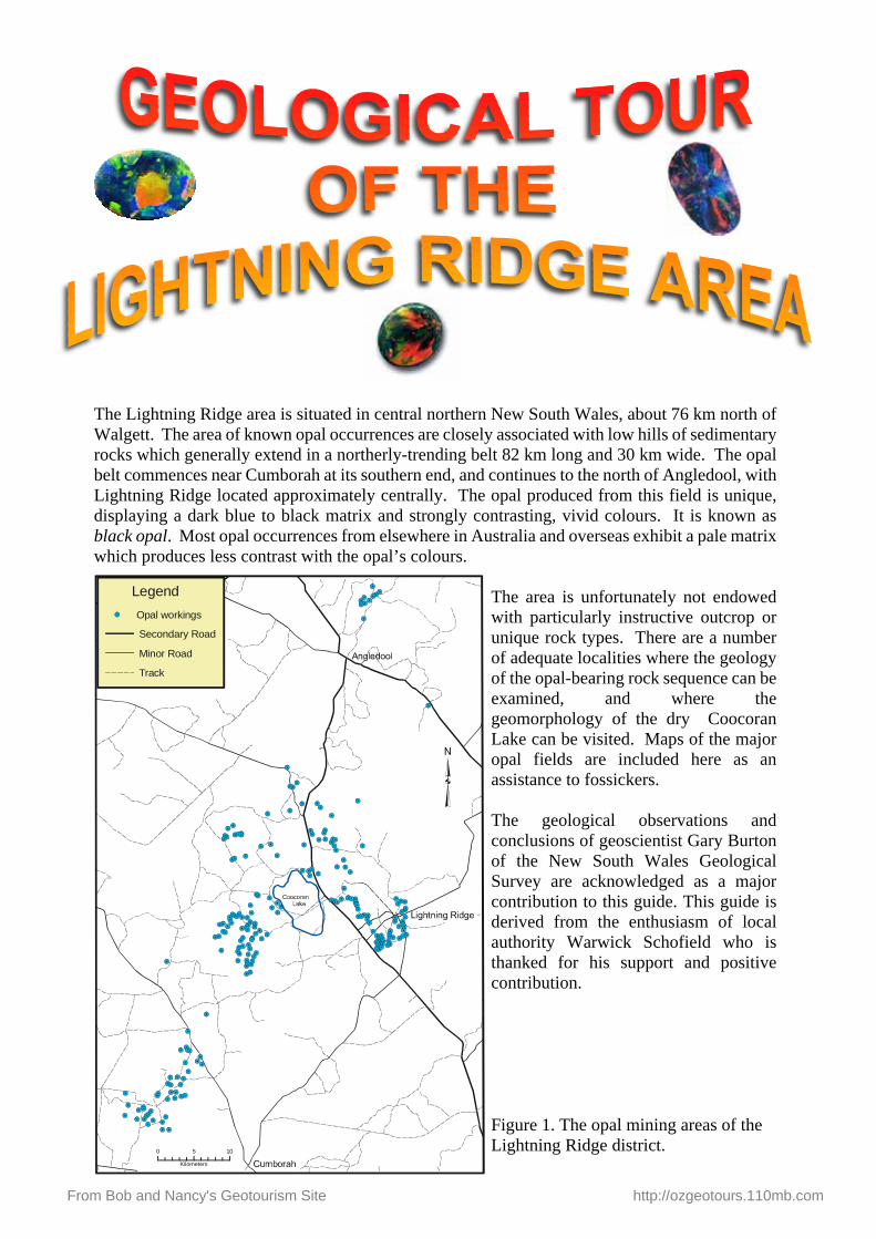
The Lightning Ridge area is situated in central northern New South Wales, about 76 km north of Walgett. The area of known opal occurrences are closely associated with low hills of sedimentary rocks which generally extend in a northerly-trending belt 82 km long and 30 km wide. The opal belt commences near Cumborah at its southern end, and continues to the north of Angledool, with Lightning Ridge located approximately centrally. The opal produced from this field is unique, displaying a dark blue to black matrix and strongly contrasting, vivid colours. It is known as black opal. Most opal occurrences from elsewhere in Australia and overseas exhibit a pale matrix which produces less contrast with the opal’s colours.
The area is unfortunately not endowed with particularly instructive outcrop or unique rock types. There are a number of adequate localities where the geology of the opal-bearing rock sequence can be examined, and where the geomorphology of the dry Coocoran Lake can be visited. Maps of the major opal fields are included here as an assistance to fossickers.
The geological observations and conclusions of geoscientist Gary Burton of the New South Wales Geological Survey are acknowledged as a major contribution to this guide. This guide is derived from the enthusiasm of local authority Warwick Schofield who is thanked for his support and positive contribution.
Figure 1. The opal mining areas of the Lightning Ridge district.0 5 10
Kilometers
LegendOpal workings
Secondary Road
Minor Road
Track
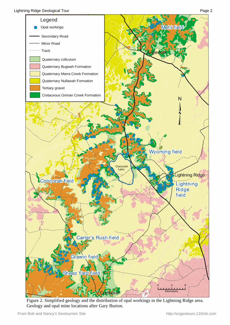
Lightning Ridge Geological Tour Page 2
From Bob and Nancy's Geotourism Site http://ozgeotours.110mb.com
Figure 2. Simplified geology and the distribution of opal workings in the Lightning Ridge area. Geology and opal mine locations after Gary Burton.
0 4 8
Kilometers
LegendOpal workings
Secondary Road
Minor Road
Track
Quaternary colluvium
Quaternary Bugwah Formation
Quaternary Marra Creek Formation
Quaternary Nullawah Formation
Tertiary gravel
Cretaceous Griman Creek Formation
Lightning Ridge Geological Tour Page 3
From Bob and Nancy's Geotourism Site http://ozgeotours.110mb.com
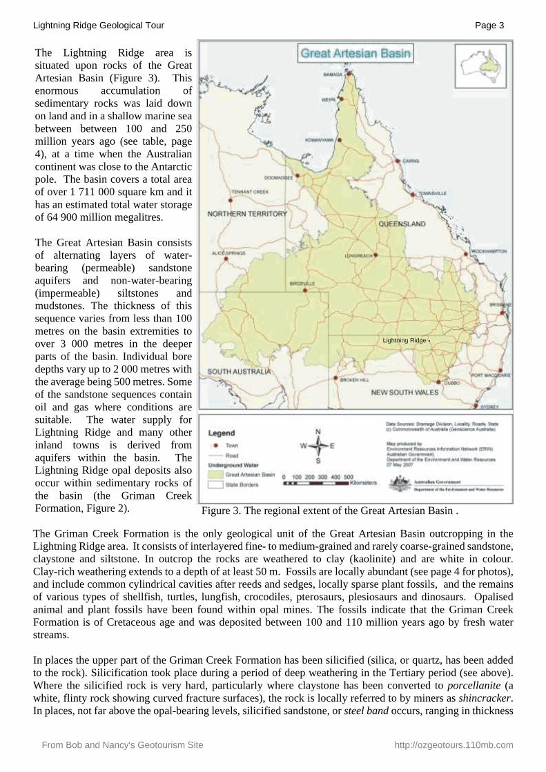
The Lightning Ridge area is situated upon rocks of the Great Artesian Basin (Figure 3). This enormous accumulation of sedimentary rocks was laid down on land and in a shallow marine sea between between 100 and 250 million years ago (see table, page 4), at a time when the Australian continent was close to the Antarctic pole. The basin covers a total area of over 1 711 000 square km and it has an estimated total water storage of 64 900 million megalitres.
The Great Artesian Basin consists of alternating layers of water-bearing (permeable) sandstone aquifers and non-water-bearing (impermeable) siltstones and mudstones. The thickness of this sequence varies from less than 100 metres on the basin extremities to over 3 000 metres in the deeper parts of the basin. Individual bore depths vary up to 2 000 metres with the average being 500 metres. Some of the sandstone sequences contain oil and gas where conditions are suitable. The water supply for Lightning Ridge and many other inland towns is derived from aquifers within the basin. The Lightning Ridge opal deposits also occur within sedimentary rocks of the basin (the Griman Creek Formation, Figure 2).
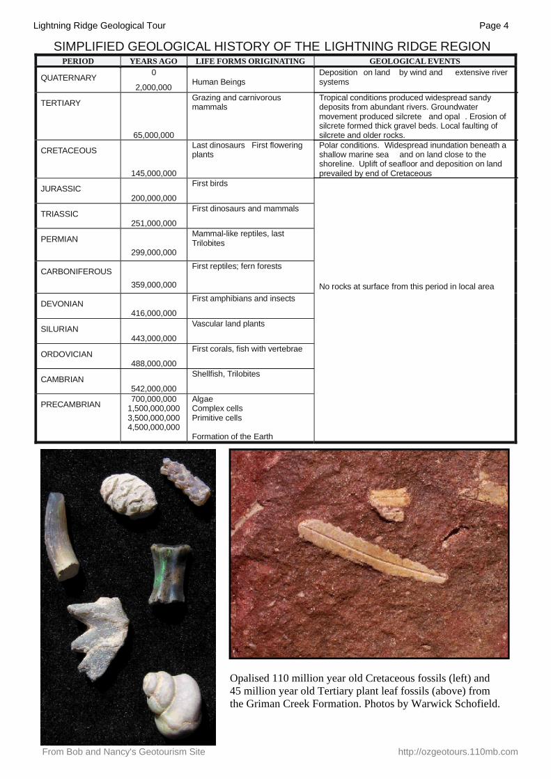
The Griman Creek Formation is the only geological unit of the Great Artesian Basin outcropping in theLightning Ridge area. It consists of interlayered fine- to medium-grained and rarely coarse-grained sandstone,claystone and siltstone. In outcrop the rocks are weathered to clay (kaolinite) and are white in colour.Clay-rich weathering extends to a depth of at least 50 m. Fossils are locally abundant (see page 4 for photos),and include common cylindrical cavities after reeds and sedges, locally sparse plant fossils, and the remainsof various types of shellfish, turtles, lungfish, crocodiles, pterosaurs, plesiosaurs and dinosaurs. Opalisedanimal and plant fossils have been found within opal mines. The fossils indicate that the Griman CreekFormation is of Cretaceous age and was deposited between 100 and 110 million years ago by fresh waterstreams.
In places the upper part of the Griman Creek Formation has been silicified (silica, or quartz, has been addedto the rock). Silicification took place during a period of deep weathering in the Tertiary period (see above).Where the silicified rock is very hard, particularly where claystone has been converted to porcellanite (a white, flinty rock showing curved fracture surfaces), the rock is locally referred to by miners as shincracker. In places, not far above the opal-bearing levels, silicified sandstone, or steel band occurs, ranging in thickness
Lightning Ridge
Figure 3. The regional extent of the Great Artesian Basin .
Lightning Ridge Geological Tour Page 4
From Bob and Nancy's Geotourism Site http://ozgeotours.110mb.com
SIMPLIFIED GEOLOGICAL HISTORY OF THE LIGHTNING RIDGE REGIONPERIOD YEARS AGO LIFE FORMS ORIGINATING GEOLOGICAL EVENTS
QUATERNARY 0
2,000,000 Human BeingsDeposition on land by wind and extensive river systems
TERTIARY
65,000,000
Grazing and carnivorous mammals
Tropical conditions produced widespread sandy deposits from abundant rivers. Groundwater movement produced silcrete and opal . Erosion of silcrete formed thick gravel beds. Local faulting of silcrete and older rocks.
CRETACEOUS
145,000,000
Last dinosaurs First flowering plants
Polar conditions. Widespread inundation beneath a shallow marine sea and on land close to the shoreline. Uplift of seafloor and deposition on land prevailed by end of Cretaceous
JURASSIC200,000,000
First birds
TRIASSIC251,000,000
First dinosaurs and mammals
PERMIAN299,000,000
Mammal-like reptiles, last Trilobites
CARBONIFEROUS359,000,000
First reptiles; fern forests
DEVONIAN416,000,000
First amphibians and insects
SILURIAN443,000,000
Vascular land plants
ORDOVICIAN488,000,000
First corals, fish with vertebrae
CAMBRIAN542,000,000
Shellfish, Trilobites
PRECAMBRIAN 700,000,0001,500,000,0003,500,000,0004,500,000,000
AlgaeComplex cellsPrimitive cells
Formation of the Earth
No rocks at surface from this period in local area
Opalised 110 million year old Cretaceous fossils (left) and 45 million year old Tertiary plant leaf fossils (above) from the Griman Creek Formation. Photos by Warwick Schofield.
Lightning Ridge Geological Tour Page 5
From Bob and Nancy's Geotourism Site http://ozgeotours.110mb.com
from several millimetres to about one metre. Steel band is not always associated with opal, but it probablyformed at the same time as opal deposits.
In places throughout the Griman Creek Formation linear zones of angular, fractured rock (breccia) occur.Local miners refer to these as blows. The blows are generally vertical and range from a few millimetres toabout two metres in width and extend to over twenty metres in depth. They consist of fragments of the GrimanCreek Formation and/or silcrete and/or quartz pebbles, supported by a matrix of white, quartz-rich sand andgrey clay. Blows are exposed at the surface at numerous localities and are commonly observed within mine workings. Some opal miners believe that blows are good indicators for opal. However, research has shownthat blows post-date both opal formation and the silicification event. Some blows cross-cut opal/potch seamsand contain angular opal/potch fragments confirming that they post-date the seams. The fact that the ‘blows’are rich in present-day surface material indicates that they are recent features. Their origin is uncertain, butthey may represent deep surface fractures which have repeatedly opened by small amounts, allowing the infilling by surface sand and gravel.
Opal occurs within the Griman Creek Formation in distinct areas or fields (see Figures 2, 4, 5, 6, 7). The main fields where opal is mined are the Coocoran, Lightning Ridge, Carters Rush–Grawin–Glengarry, Wyoming,Muttabun–Allawah and Mehi areas. Opal occurs as horizontal seams, nodules (nobbies) and as replacementsand cast fillings after fossils. It is commonly developed within the upper parts (approximately the upper onemetre) of claystone lenses which are referred to by miners as levels and the claystone itself is referred to as opal dirt. The opal-bearing claystone is always overlain by a thick sandstone layer. Recoverable opal is foundwithin 30 m of the surface and has been worked mainly by underground methods, though some open cutmining has been carried out. Generally a single claystone layers is mined, although in some places two ormore opal-bearing claystones (referred to as levels by miners) are present.
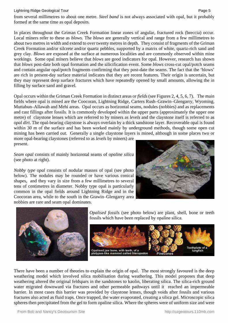
Seam opal consists of mainly horizontal seams of opaline silica (see photo at right).
Nobby type opal consists of nodular masses of opal (see photo below). The nodules may be rounded or have various conical shapes, and they vary in size from a few millimetres to several tens of centimetres in diameter. Nobby type opal is particularly common in the opal fields around Lightning Ridge and in the Coocoran area, while to the south in the Grawin–Glengarry area nobbies are rare and seam opal dominates.
Opalised fossils (see photo below) are plant, shell, bone or teethfossils which have been replaced by opaline silica.
There have been a number of theories to explain the origin of opal. The most strongly favoured is the deepweathering model which involved silica mobilisation during weathering. This model proposes that deepweathering altered the original feldspars in the sandstones to kaolin, liberating silica. The silica-rich groundwater migrated downward via fractures and other permeable pathways until it reached an impermeablebarrier. In most cases this barrier was provided by claystone lenses, though voids after fossils and variousfractures also acted as fluid traps. Once trapped, the water evaporated, creating a silica gel. Microscopic silicaspheres then precipitated from the gel to form opaline silica. Where the spheres were of uniform size and were
Lightning Ridge Geological Tour Page 6
From Bob and Nancy's Geotourism Site http://ozgeotours.110mb.com
regularly packed, precious opal was formed. Where the spheres were variable in size and not regularly packed,potch, or common opal, developed.
The opal-bearing Griman Creek Formation is overlain locally by silicified sandstone and conglomerate ofTertiary (Eocene) age. This sandstone, the Eyre Formation, was deposited between about 37 and 55 millionyears ago across much of inland central Australia by creeks and in lakes similar to those in the ChannelCountry of southwest Queensland. The pebbles are characterised by their small size, high degree of rounding,dominance of white quartz, and very glossy surfaces. The sandstone and conglomerate was subjected to atleast one deep weathering event during the Tertiary (about 33 million years ago) which resulted in themovement of large volumes of dissolved silica. Some of this silica formed opal within the underlyingCretaceous rocks, whilst the bulk of the silica precipitated closer to the surface in porous sandstone andconglomerate layers. The resulting, hard, silica-rich rock is known as silcrete. The natural erosion-resistant qualities of this rock has resulted in its preservation on the crests of hills and ridges.
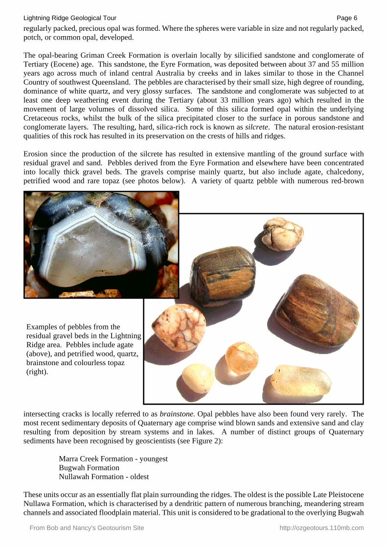
Erosion since the production of the silcrete has resulted in extensive mantling of the ground surface withresidual gravel and sand. Pebbles derived from the Eyre Formation and elsewhere have been concentratedinto locally thick gravel beds. The gravels comprise mainly quartz, but also include agate, chalcedony,petrified wood and rare topaz (see photos below). A variety of quartz pebble with numerous red-brown
intersecting cracks is locally referred to as brainstone. Opal pebbles have also been found very rarely. Themost recent sedimentary deposits of Quaternary age comprise wind blown sands and extensive sand and clayresulting from deposition by stream systems and in lakes. A number of distinct groups of Quaternarysediments have been recognised by geoscientists (see Figure 2):
Marra Creek Formation - youngestBugwah FormationNullawah Formation - oldest
These units occur as an essentially flat plain surrounding the ridges. The oldest is the possible Late PleistoceneNullawa Formation, which is characterised by a dendritic pattern of numerous branching, meandering streamchannels and associated floodplain material. This unit is considered to be gradational to the overlying Bugwah
Examples of pebbles from theresidual gravel beds in the LightningRidge area. Pebbles include agate(above), and petrified wood, quartz, brainstone and colourless topaz (right).
Lightning Ridge Geological Tour Page 7
From Bob and Nancy's Geotourism Site http://ozgeotours.110mb.com
Lake Coocoran
Long's Rush (Kellie's Western Fall)
T Bone (part)
Warrengulla
Steen's (part)
Steen's (part)
Old Coocoran
KK
CC
Olga's
Cody's
Tyrones
Smith's
Sceek's
Red Eye
Rainbow
Marie's
Klaus's
Kevin's
Joyce's
Jenny's
The Nest
Red Post
Martin's
Dawson's
White Peg
The Rocks
Moonshine
Hard Hill
Molyneux's
Kellie's 6
Kellie's 5
Kellie's 1
Greenacres
Three Trees
Rainbow West
Ormie's Luck
New Coocoran
Greenacres 2 Emu's (part)
Emu's (part)
T Bone (part)
Ken's Retreat
Granny's Flat
Norway (north)
Natalies Dream 2Natalies Dream 1
Dead Bird (part)
Kellie’s 4 Extension
Greenacres 3 (part)Greenacres 3 (part)
T Bone 2 extension (part)
Allah's Rush (Kellie's 3)
570000
570000
580000
580000
6740
000
6740
000
0 0.7 1.4
Kilometers
LegendOpal workings
Secondary Road
Minor Road
Track
Quaternary colluvium
Quaternary Bugwah Formation
Quaternary Marra Creek Formation
Quaternary Nullawah Formation
Tertiary gravel
Cretaceous Griman Creek Formation
T Bone (part)T Bone (part)
Norway (south)
Cheryl’s (Kellie’s 4)
T Bone 2 extension (part) Dead Bird (part)
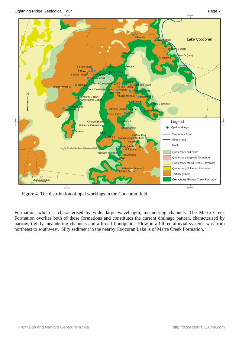
Figure 4. The distribution of opal workings in the Coocoran field.
Formation, which is characterised by wide, large wavelength, meandering channels. The Marra CreekFormation overlies both of these formations and constitutes the current drainage pattern, characterised bynarrow, tightly meandering channels and a broad floodplain. Flow in all three alluvial systems was fromnortheast to southwest. Silty sediment in the nearby Coocoran Lake is of Marra Creek Formation.
Lightning Ridge Geological Tour Page 8
From Bob and Nancy's Geotourism Site http://ozgeotours.110mb.com
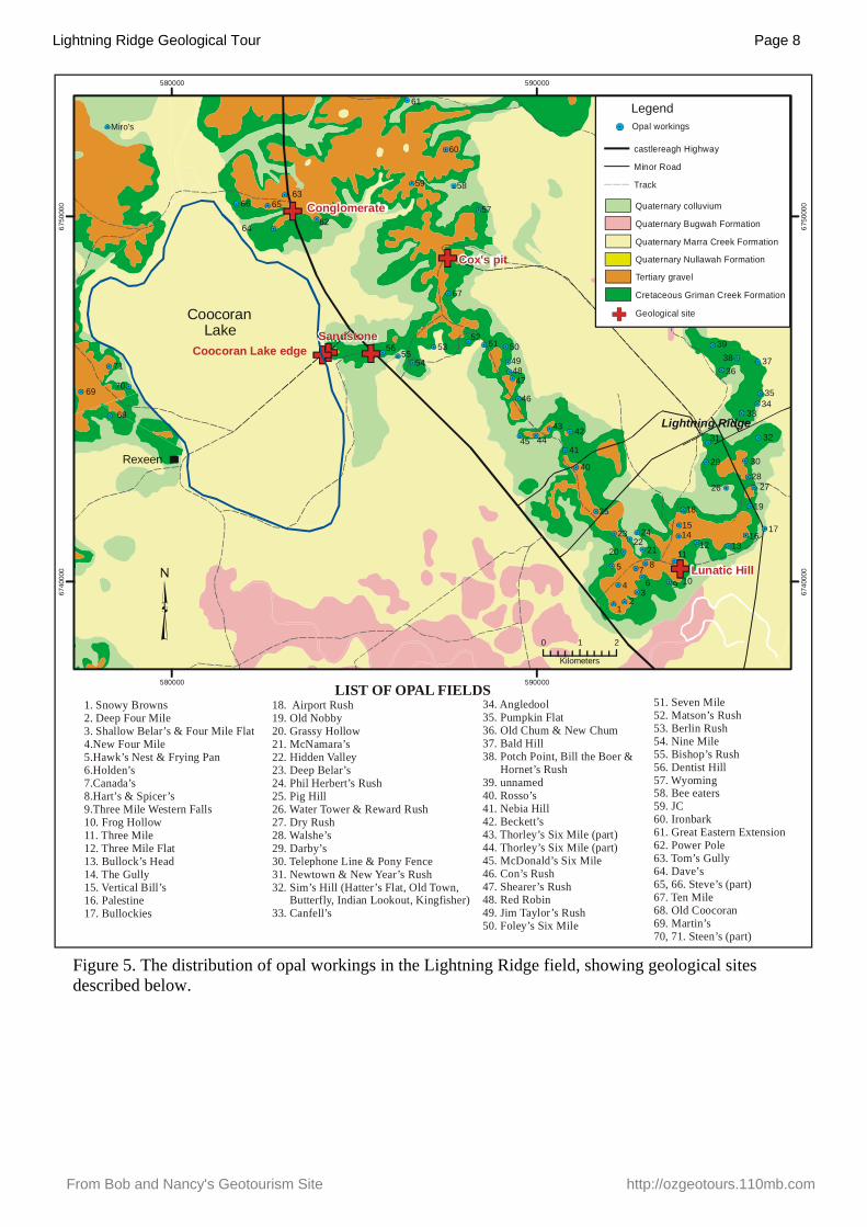
Figure 5. The distribution of opal workings in the Lightning Ridge field, showing geological sites described below.
Lightning Ridge
Coocoran edgeLake
Conglomerate
59
Miro's
57
39
40 2928
67
25
69
60
6
14
48
16
54
42
11
51
62
41
46
5863
10
23
53
1
56
18
47
2
13
15
5049
61
43
Cox's pit
Lunatic Hill
580000
580000
590000
590000
6740
000
6740
000
6750
000
6750
000
0 1 2
Kilometers
LegendOpal workings
castlereagh Highway
Minor Road
Track
Quaternary colluvium
Quaternary Bugwah Formation
Quaternary Marra Creek Formation
Quaternary Nullawah Formation
Tertiary gravel
Cretaceous Griman Creek Formation
LakeCoocoran
Rexeen
71
68
70
66 65
64
55
Sandstone 52
45 44
3638 37
3534
33
31
30
32
26 27
34
5 7 8
9
12
17
19
20 2122
24
1. Snowy Browns2. Deep Four Mile3. Shallow Belar’s & Four Mile Flat4.New Four Mile5.6.Holden’s7.Canada’s8.Hart’s & Spicer’s9.Three Mile Western Falls10. Frog Hollow11. Three Mile12. Three Mile Flat13. Bullock’s Head14. The Gully15. Vertical Bill’s
Hawk’s Nest & Frying Pan
16. Palestine17. Bullockies
18. Airport Rush19. Old Nobby20. Grassy Hollow21. McNamara’s22. Hidden Valley23. Deep Belar’s 24. Phil Herbert’s Rush25. Pig Hill26. Water Tower & Reward Rush27. Dry Rush28. Walshe’s29. Darby’s30. Telephone Line & Pony Fence31. Newtown & New Year’s Rush32. Sim’s Hill (Hatter’s Flat, Old Town, Butterfly, Indian Lookout, Kingfisher)33. Canfell’s
34. Angledool35. Pumpkin Flat36. Old Chum & New Chum37. Bald Hill38. Potch Point, Bill the Boer & Hornet’s Rush39. unnamed40. Rosso’s41. Nebia Hill42. Beckett’s43. Thorley’s Six Mile (part)44. Thorley’s Six Mile (part)45. McDonald’s Six Mile46. Con’s Rush47. Shearer’s Rush48. Red Robin49. Jim Taylor’s Rush50. Foley’s Six Mile
51. Seven Mile52. Matson’s Rush53. Berlin Rush54. Nine Mile55. Bishop’s Rush56. Dentist Hill57. Wyoming58. Bee eaters59. JC60. Ironbark61. Great Eastern Extension62. Power Pole63. Tom’s Gully64. Dave’s65, 66. Steve’s (part)67. Ten Mile68. Old Coocoran69. Martin’s70, 71. Steen’s (part)
LIST OF OPAL FIELDS
Geological site
Lightning Ridge Geological Tour Page 9
From Bob and Nancy's Geotourism Site http://ozgeotours.110mb.com
Mehi 7
Spiders
Rainah's
Mehi (part)
Mehi (part)
Eagle's Nest
Watson's Reward
Billy Goat Hill
Itchy and Scratchy
The Springs and Harrison's Folly
590000
590000
6790
000
6790
000
0 0.25 0.5
Kilometers
LegendOpal workings
Secondary Road
Minor Road
Track
Quaternary colluvium
Quaternary Bugwah Formation
Quaternary Marra Creek Formation
Quaternary Nullawah Formation
Tertiary gravel
Cretaceous Griman Creek Formation
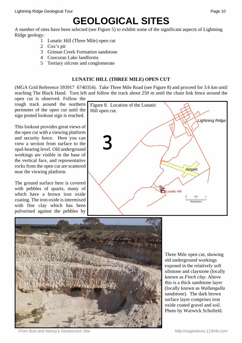
Figure 7. The distribution of opal workings in the Mehiarea.
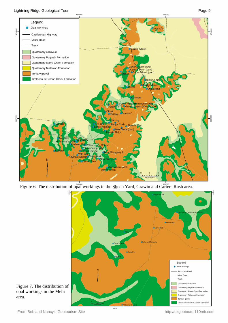
Figure 6. The distribution of opal workings in the Sheep Yard, Grawin and Carters Rush area.
560000
560000
570000
570000
6720
000
6720
000
6730
000
6730
000
0 1 2
Kilometers
LegendOpal workings
Castlereagh Highway
Minor Road
Track
Quaternary colluvium
Quaternary Bugwah Formation
Quaternary Marra Creek Formation
Quaternary Nullawah Formation
Tertiary gravel
Cretaceous Griman Creek Formation
Lightning Ridge Geological Tour Page 10
From Bob and Nancy's Geotourism Site http://ozgeotours.110mb.com
GEOLOGICAL SITESA number of sites have been selected (see Figure 5) to exhibit some of the significant aspects of Lightning Ridge geology:
1 Lunatic Hill (Three Mile) open cut2 Cox’s pit3 Griman Creek Formation sandstone4 Coocoran Lake landforms5 Tertiary silcrete and conglomerate
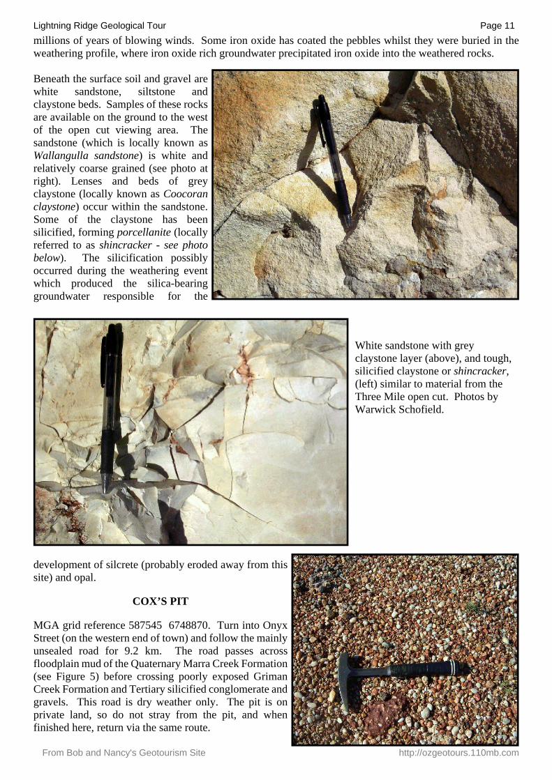
LUNATIC HILL (THREE MILE) OPEN CUT
(MGA Grid Reference 593917 6740354). Take Three Mile Road (see Figure 8) and proceed for 3.6 km untilreaching The Black Hand. Turn left and follow the track about 250 m until the chain link fence around theopen cut is observed. Follow the rough track around the northern perimeter of the open cut until the sign posted lookout sign is reached.
This lookout provides great views of the open cut with a viewing platform and security fence. Here you can view a section from surface to the opal-bearing level. Old underground workings are visible in the base of the vertical face, and representative rocks from the open cut are scattered near the viewing platform.
The ground surface here is covered with pebbles of quartz, many of which have a brown iron oxide coating. The iron oxide is intermixed with fine clay which has been pulverised against the pebbles by
GF
Lightning Ridge
Airport
Lunatic Hill0 0.5 1
Kilometers
³
Figure 8. Location of the LunaticHill open cut.
Three Mile open cut, showingold underground workingsexposed in the relatively softsiltstone and claystone (locally known as Finch clay. Abovethis is a thick sandstone layer (locally known as Wallangulla sandstone). The dark brown surface layer comprises iron oxide coated gravel and soil. Photo by Warwick Schofield.
Lightning Ridge Geological Tour Page 11
From Bob and Nancy's Geotourism Site http://ozgeotours.110mb.com
millions of years of blowing winds. Some iron oxide has coated the pebbles whilst they were buried in theweathering profile, where iron oxide rich groundwater precipitated iron oxide into the weathered rocks.
Beneath the surface soil and gravel are white sandstone, siltstone and claystone beds. Samples of these rocks are available on the ground to the west of the open cut viewing area. The sandstone (which is locally known as Wallangulla sandstone) is white and relatively coarse grained (see photo at right). Lenses and beds of grey claystone (locally known as Coocoran claystone) occur within the sandstone. Some of the claystone has been silicified, forming porcellanite (locally referred to as shincracker - see photo below). The silicification possibly occurred during the weathering event which produced the silica-bearing groundwater responsible for the
development of silcrete (probably eroded away from this site) and opal.
COX’S PIT
MGA grid reference 587545 6748870. Turn into Onyx Street (on the western end of town) and follow the mainly unsealed road for 9.2 km. The road passes across floodplain mud of the Quaternary Marra Creek Formation (see Figure 5) before crossing poorly exposed Griman Creek Formation and Tertiary silicified conglomerate and gravels. This road is dry weather only. The pit is on private land, so do not stray from the pit, and when finished here, return via the same route.
White sandstone with grey claystone layer (above), and tough,silicified claystone or shincracker, (left) similar to material from the Three Mile open cut. Photos byWarwick Schofield.
Lightning Ridge Geological Tour Page 12
From Bob and Nancy's Geotourism Site http://ozgeotours.110mb.com
This road material pit is developed in Tertiary conglomerate. The site covers a large area, and offers thepotential to fossick for agate, chalcedony, attractive quartz pebbles, and possibly topaz. Note the iron oxideveneer on many pebbles, and the boulders of silicified quartz pebble conglomerate.
GRIMAN CREEK FORMATION
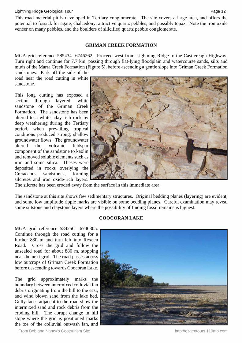
MGA grid reference 585434 6746262. Proceed west from Lightning Ridge to the Castlereagh Highway.Turn right and continue for 7.7 km, passing through flat-lying floodplain and watercourse sands, silts andmuds of the Marra Creek Formation (Figure 5), before ascending a gentle slope into Griman Creek Formationsandstones. Park off the side of the road near the road cutting in white sandstone.
This long cutting has exposed a section through layered, white sandstone of the Griman Creek Formation. The sandstone has been altered to a white, clay-rich rock by deep weathering during the Tertiary period, when prevailing tropical conditions produced strong, shallow groundwater flows. The groundwater altered the volcanic feldspar component of the sandstone to kaolin and removed soluble elements such as iron and some silica. Theses were deposited in rocks overlying the Cretaceous sandstones, forming silcretes and iron oxide-rich layers. The silcrete has been eroded away from the surface in this immediate area.
The sandstone at this site shows few sedimentary structures. Original bedding planes (layering) are evident,and some low amplitude ripple marks are visible on some bedding planes. Careful examination may revealsome siltstone and claystone layers where the possibility of finding fossil remains is highest.
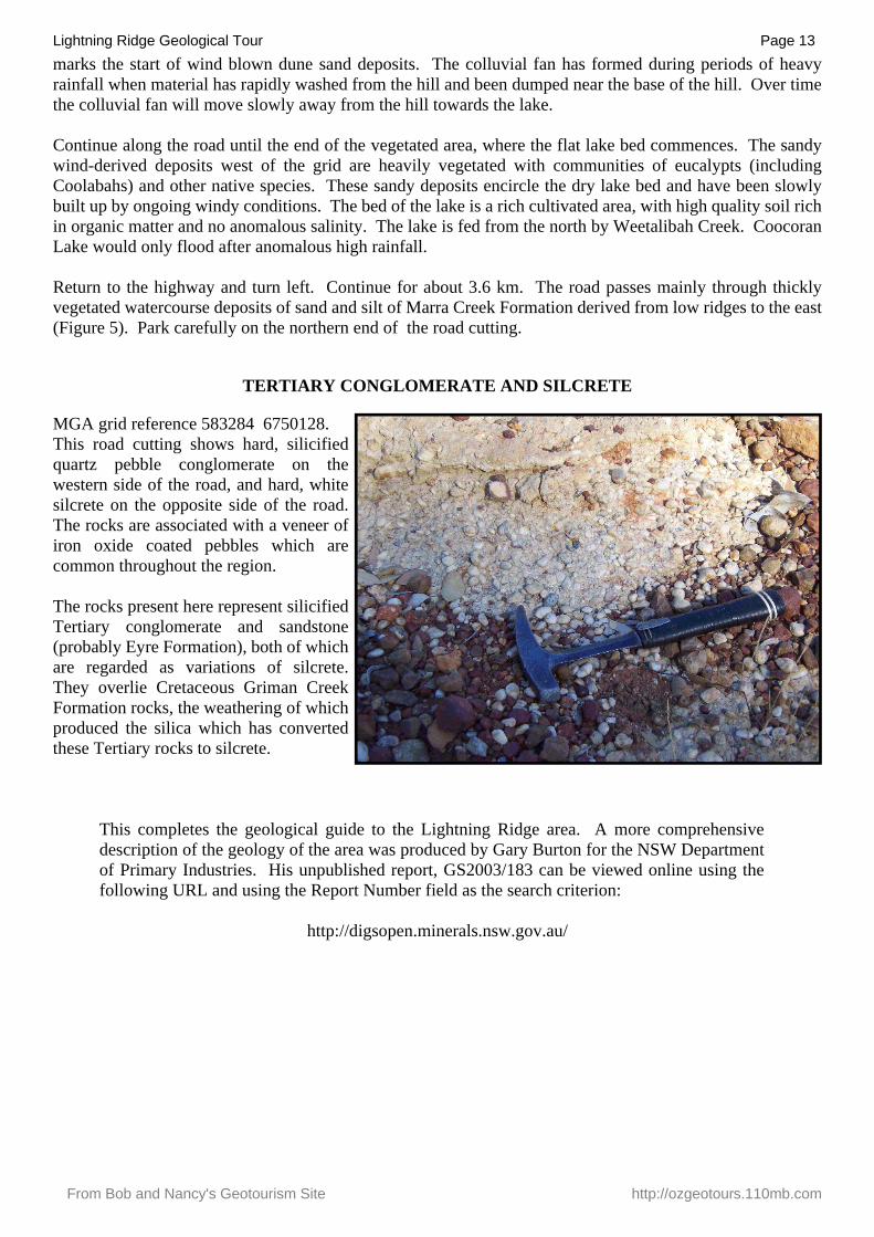
COOCORAN LAKE
MGA grid reference 584256 6746305. Continue through the road cutting for a further 830 m and turn left into Rexeen Road. Cross the grid and follow the unsealed road for about 880 m, stopping near the next grid. The road passes across low outcrops of Griman Creek Formation before descending towards Coocoran Lake.
The grid approximately marks the boundary between intermixed colluvial fan debris originating from the hill to the east, and wind blown sand from the lake bed. Gully faces adjacent to the road show the intermixed sand and rock debris from the eroding hill. The abrupt change in hill slope where the grid is positioned marks the toe of the colluvial outwash fan, and
Lightning Ridge Geological Tour Page 13
From Bob and Nancy's Geotourism Site http://ozgeotours.110mb.com
marks the start of wind blown dune sand deposits. The colluvial fan has formed during periods of heavyrainfall when material has rapidly washed from the hill and been dumped near the base of the hill. Over timethe colluvial fan will move slowly away from the hill towards the lake.
Continue along the road until the end of the vegetated area, where the flat lake bed commences. The sandywind-derived deposits west of the grid are heavily vegetated with communities of eucalypts (includingCoolabahs) and other native species. These sandy deposits encircle the dry lake bed and have been slowlybuilt up by ongoing windy conditions. The bed of the lake is a rich cultivated area, with high quality soil richin organic matter and no anomalous salinity. The lake is fed from the north by Weetalibah Creek. CoocoranLake would only flood after anomalous high rainfall.
Return to the highway and turn left. Continue for about 3.6 km. The road passes mainly through thicklyvegetated watercourse deposits of sand and silt of Marra Creek Formation derived from low ridges to the east(Figure 5). Park carefully on the northern end of the road cutting.
TERTIARY CONGLOMERATE AND SILCRETE
MGA grid reference 583284 6750128.This road cutting shows hard, silicified quartz pebble conglomerate on the western side of the road, and hard, white silcrete on the opposite side of the road. The rocks are associated with a veneer of iron oxide coated pebbles which are common throughout the region.
The rocks present here represent silicified Tertiary conglomerate and sandstone (probably Eyre Formation), both of which are regarded as variations of silcrete. They overlie Cretaceous Griman Creek Formation rocks, the weathering of which produced the silica which has converted these Tertiary rocks to silcrete.
This completes the geological guide to the Lightning Ridge area. A more comprehensive description of the geology of the area was produced by Gary Burton for the NSW Department of Primary Industries. His unpublished report, GS2003/183 can be viewed online using the following URL and using the Report Number field as the search criterion:
http://digsopen.minerals.nsw.gov.au/