Embed Size (px)
Citation preview
UNITED STATES DEPARTMENT OF THE INTERIOR
GEOLOGICAL SURVEY
Geology and petroleum resources of central and east-central Africa
By
James A. Peterson*
Open-File Report 85-589
This report is preliminary and has not been reviewed for conformity with U.S. Geological Survey editorial standards and stratigraphic nomenclature
Missoula, Montana
1985
CONTENTS
Page
Abs tract 1Introduction 2
Sources of Information 2Geography 2
Acknowledgment s 2Regional geology 5
Structure 5Horn of Africa 5Plateau and rift belt 11Red Sea and Gulf of Aden Basins 13Central Africa interior basins 13
Upper Nile Basin (Sudan trough) 13Chad, Doba-Doseo (Chari), and lullemmeden (Niger)
Basins 13Benue trough 15
Stratigraphy 15Precambrian 19Paleozoic 19Mesozoic 21East-central Africa 21
Jurassic 21Cretaceous 22Tertiary 22
Central Africa interior basins 26Benue trough 27
Petroleum geology 27Somali basin 28
Res ervo i r s 2 9Source rocks 29Seals 29Traps 2 9Estimated resources 30
Plateau and rift belt 30Red Sea Basin (western half) 30
Reservoirs 30Source rocks 34Seals 34Traps 34Estimated resources 34
Central Africa interior basins 34Reservoirs, source rocks, seals 36Traps 36Estimated resources 36
Benue trough 40Res er voi r s 4 0Source rocks 40Seals 40Traps 40Estimated resources 40
CONTENTS (continued)Page
Resource assessment 42Procedures 42As s es smen t 4 3Comments 43
Selected references 45
ILLUSTRATIONS
Figure 1. Index map of north and central Africa 32. Generalized structural map of central and east Africa 43. Correlation chart, central and east-central Africa 64. Approximate thickness of sedimentary cover in thousands
of meters 75. North-south structural-stratigraphic cross-section A-A ! ,
southeast Kenya to Gulf of Aden 8 6-10. West-east structural-stratigraphic cross-section:
6. B-B T , northern Kenya to Indian Ocean 97. C-C T , western Ethiopia to Indian Ocean 128. D-D T , southern Red Sea Basin 149. F-E-C, Doba-Doseo and Upper Nile Basins 16
10. G-F, lullemmeden and Chad Basins 1711. Southwest-northeast structural-stratigraphic cross-section
H-H T , Niger Delta to southern Chad 18
12. Approximate thickness of Jurassic sedimentary rocks inthousands of meters 20
13. Approximate thickness of Cretaceous sedimentary rocks inthousands of meters 23
14. Approximate thickness of Tertiary sedimentary rocks inthousands of meters 25
15-26. Unconditional estimates of undiscovered recoverable:15. Oil in the Somali Basin 3116. Total gas in the Somali Basin 3117. Oil in the Red Sea Basin 3518. Total gas in the Red Sea Basin 3519. Oil in the Upper Nile Basin (Sudan trough) 3720. Total gas in the Upper Nile Basin (Sudan trough) 3721. Oil in the Chad and Doba-Doseo (Chari) Basins 3822. Total gas in the Chad and Doba-Doseo (Chari) Basins 3823. Oil in the lullemmeden (Niger) Basin - 3924. Total gas in the lullemmeden (Niger) Basin 3925. Oil in the Benue trough 4126. Total gas in the Benue trough 41
TABLES
Table 1. Assessment of undiscovered conventionally recoverablepetroleum resources of central and east-central Africa 32
2. Supplemental and comparative data supporting theresource assessment for central and east-central Africa 33
ii
GEOLOGY AND PETROLEUM RESOURCES OF CENTRAL AND EAST-CENTRAL AFRICA
By James A. Peterson
ABSTRACT
The petroleum provinces of central and east-central Africa include the Somali Basin, the Ethiopian plateau and rift belt, the Red Sea Basin, and the central African rift basins. The east African shelf (Somali Basin) in the "Horn of Africa" contains a sedimentary cover 1,000 to 10,000 m (3,000 to 35,000 ft) thick of Mesozoic and Tertiary marine and continental clastic, carbonate and evaporite deposits with good reservoir and potentially adequate source-rock properties. To date, approximately 85 exploratory wells have been drilled in this province and no commercial oil or gas discoveries have been made. Most of the drilling has been on fold and fault structures, many of which were inadequately mapped by geophysical means. Testing for stratigraphic traps has been minimal.
Offshore drilling on the western shelf of the Red Sea Basin has encountered numerous indications of gas from sandstones in the 5,000 m (16,000 ft) or more of Miocene and younger marine and continental clastic and evaporite beds. The Red Sea shelf probably is a gas-prone province of high exploration risk because of high geothermal gradients and uncertain structural conditions, particularly below the salt, probably related to spreading and rifting and to severe flowage of the thick Miocene salt deposits.
The Ethiopian plateau and rift belt is a very high exploration risk area that has minimum potential for commercial oil and gas deposits because of high geothermal gradients in the rift areas, extensive volcanism, and inadequate marine deposits and petroleum source rocks, in part related to the Neogene rifting origin of the province.
The interior basins of central Africa are rifted cratonic depressions in which Late Cretaceous and Tertiary fluvial and lacustrine clastic beds, as thick as 6,000 m (20,000 ft) or more, intertongue with nearshore marine clastic and carbonate deposits in the western basins. Since the middle 1970's, approximately 13 oil discoveries in the Upper Nile, Doba-Doseo (Chari), and Chad Basins are producing from fluvial and lacustrine sandstone reservoirs. Source rocks are lacustrine organic shale beds of Cretaceous age.
The Benue trough is a rifted depression of middle Cretaceous age adjoined on the southwest by the prolific Niger Delta petroleum province. The trough is filled with 6,000 m (20,000 ft) or more of clastic and carbonate marine and continental rocks of late Early Cretaceous and early Cenozoic age. Very few exploratory wells have been drilled, and no commercial discoveries have been made, although good reservoir and source rocks are present. The Benue trough is a high exploration risk province because of its complicated structural and thermal history.
USGS estimates of original recoverable petroleum resources (ultimate) of the central and east-central Africa provinces as of December 1982 are approxi mately 21 billion barrels of oil (BBO) and 83 trillion cubic feet (Tcf) of gas, most of which is in the Upper Nile, Chad, and Doba-Doseo (Chari) Basins.
INTRODUCTION
Sources of Information
Data and information used in preparing this report were compiled from many sources, particularly the reports of Barnes (1976), Kamen-Kaye and Barnes (1979), Whiteman (1971a, 1981), Fetters (1978a, 1979a, b, 1981), Turner, (1971a, b), Walters and Linton (1973), Mohr (1971), Nairn (1978), Beltrandi and Pyre (1973), Burke and others (1972), Furon (1963), articles in The Oil and Gas Journal and World Oil, and the information files of Petroconsultants, S.A. Additional sources are listed in the selected references. Work on the assessment study was completed in December 1982, and in most cases the report does not include available information after that date.
Geography
The petroleum provinces described and assessed in this report include (1) the Somali, Ogaden, Mandera-Lugh, and Lamu Basins in Somalia, eastern Ethiopia and eastern Kenya; (2) the central Ethiopian rift basins; (3) the Red Sea Basin; (4) the Upper Nile Basin (Sudan trough) in southern Sudan; (5) the Doba-Doseo (Chari) Basin in southern Chad and Central African Republic; (6) the Chad Basin in west-central Chad; (7) the lullemmeden (Niger) Basin in western Niger; and (8) the Benue trough in eastern Nigeria (figs. 1 and 2). The topography of this region ranges from the relatively flat, eastward-sloping plain of Somalia and eastern Kenya and the high plateau and rift valley region of central Ethiopia to the generally low-lying basin and hill area of Sudan, Chad, and Niger. Elevations in the central Africa basins region generally are less than 500 m (1,500 ft), with bordering uplift areas of Precambrian rocks 1,000 to 2,000 m (3,000 to 6,000 ft), rarely to 3,000 m (10,000 ft), in elevation. Climate of the region ranges from the dry desert areas of coastal northeast Somalia, the Gulf of Aden, and the Red Sea to the desert to semidesert regions of central Sudan, Chad, and Niger. Southernmost Sudan and Chad and eastern Nigeria lie on the northern border of the equatorial rain forest belt, and their precipitation is 40 in (100 cm) or more per year.
ACKNOWLEDGMENTS
This report benefited from constructive reviews and discussions by J. Kingston, C. D. Masters, W. C. Butler, and J. W. Clarke, Jr.; members of the Resource Appraisal Group, U.S. Geological Survey; J. M. Beall, Shell Oil Co.; M. Kamen-Kay, consultant; S. W. Petters, University of Calabar, Nigeria; and R. G. H. Raynolds, Amoco Production Co.
BOP
id"-
Bos
erne
nt
Roc
ks
Exp
osed
at
S
urf
ace
Bo
un
do
ry
of
Ass
essm
ent
Are
aco
'mm
etci
all
0
100
200
^ 590
BOO
mi.
t E
xp|o
roto
r
lOO
OU
m
Figu
re 1. Index ma
p of north
and
central
Afri
ca showing
asse
ssme
nt provinces,
oil
fiel
ds,
gas
disc
over
ies,
and
expl
orat
ion wells
in ce
ntra
l and
east-central Af
rica
. Assessment pr
ovin
ces
as fo
llow
s:
I, Somali
Basin; II
, Pl
atea
u an
d ri
ft be
lt;
III,
Re
d Se
a Basin; IV
, Upper
Nile Basin
(Sudan trough); V,
Doba-
Doseo
(Chari)
Basi
n; VI,
Chad Ba
sin;
VI
I lu
llem
mede
n (Niger Basin);
and
VIII
, Benue
trough.
/N
1\
I U
\\
X
A T
O \
/7 A
T
.rfV
) R
M
100
2jCX)
59
0
Figure 2. Generalized st
ruct
ural
ma
p of central
and
east Africa showing
main structural features,
basins,
and
uplifts.
Data primarily
from Bar
nes
(197
6),
Belt
rand
i and
Pyre (1
973)
, Bl
ant
(197
3),
Kame
n-Ka
ye and
Barn
es
(197
9),
Mohr (1
971)
, Ol
ade
(197
5),
Pallister
(197
1),
Turner (1
971)
, Vail (1978),
Walters
and Li
nton
(1973),
Whiteman (1971a,
b),
Lowell and
Genik
(197
2),
and
Ahmed
(1972).
REGIONAL GEOLOGY
Structure
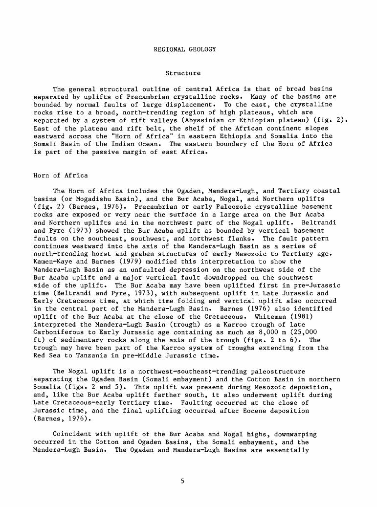
The general structural outline of central Africa is that of broad basins separated by uplifts of Precambrian crystalline rocks. Many of the basins are bounded by normal faults of large displacement. To the east, the crystalline rocks rise to a broad, north-trending region of high plateaus, which are separated by a system of rift valleys (Abyssinian or Ethiopian plateau) (fig. 2) East of the plateau and rift belt, the shelf of the African continent slopes eastward across the "Horn of Africa" in eastern Ethiopia and Somalia into the Somali Basin of the Indian Ocean. The eastern boundary of the Horn of Africa is part of the passive margin of east Africa.
Horn of Africa
The Horn of Africa includes the Ogaden, Mandera-Lugh, and Tertiary coastal basins (or Mogadishu Basin), and the Bur Acaba, Nogal, and Northern uplifts (fig. 2) (Barnes, 1976). Precambrian or early Paleozoic crystalline basement rocks are exposed or very near the surface in a large area on the Bur Acaba and Northern uplifts and in the northwest part of the Nogal uplift. Beltrandi and Pyre (1973) showed the Bur Acaba uplift as bounded by vertical basement faults on the southeast, southwest, and northwest flanks. The fault pattern continues westward into the axis of the Mandera-Lugh Basin as a series of north-trending horst and graben structures of early Mesozoic to Tertiary age. Kamen-Kaye and Barnes (1979) modified this interpretation to show the Mandera-Lugh Basin as an unfaulted depression on the northwest side of the Bur Acaba uplift and a major vertical fault downdropped on the southwest side of the uplift. The Bur Acaba may have been uplifted first in pre-Jurassic time (Beltrandi and Pyre, 1973), with subsequent uplift in Late Jurassic and Early Cretaceous time, at which time folding and vertical uplift also occurred in the central part of the Mandera-Lugh Basin. Barnes (1976) also identified uplift of the Bur Acaba at the close of the Cretaceous. Whiteman (1981) interpreted the Mandera-Lugh Basin (trough) as a Karroo trough of late Carboniferous to Early Jurassic age containing as much as 8,000 m (25,000 ft) of sedimentary rocks along the axis of the trough (figs. 2 to 6). The trough may have been part of the Karroo system of troughs extending from the Red Sea to Tanzania in pre-Middle Jurassic time.
The Nogal uplift is a northwest-southeast-trending paleostructure separating the Ogaden Basin (Somali embayment) and the Cotton Basin in northern Somalia (figs. 2 and 5). This uplift was present during Mesozoic deposition, and, like the Bur Acaba uplift farther south, it also underwent uplift during Late Cretaceous-early Tertiary time. Faulting occurred at the close of Jurassic time, and the final uplifting occurred after Eocene deposition (Barnes, 1976).
Coincident with uplift of the Bur Acaba and Nogal highs, downwarping occurred in the Cotton and Ogaden Basins, the Somali embayment, and the Mandera-Lugh Basin. The Ogaden and Mandera-Lugh Basins are essentially
NIG
ER
11'
(IULL
EM
ME
DE
N)
BA
SIN
NU
BIA
N
SS
YIR
OL
FM
.1
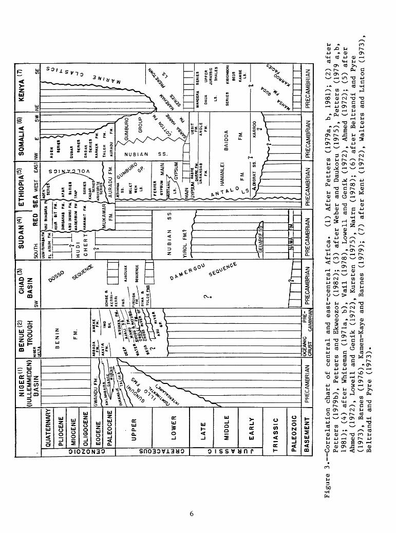
Figure 3. Correlation ch
art
of central
and
east
-cen
tral
Af
rica
. (1
) After
Fett
ers
(1979a,
b, 19
81);
(2)
after
Fett
ers
(197
9b),
Fetters
and
Ekwe
ozor
(1
982)
; (3)
afte
r Weber
and
Daukoru
(197
5),
Fetters
(197
9 a,b,
1981); (4
) af
ter
Whiteman (1
971a
, b),
Vail
(1978),
Lowell and
Genik
(197
2),
Ahmed
(1972);
(5)
after
Ahme
d (1972),
Lowell and
Genik
(197
2),
Kursten
(1975),
Nairn
(1978);
(6)
after
Belt
rand
i and
Pyre
(197
3),
Barn
es (1
976)
, Kamen-Kaye an
d Ba
rnes
(1
979)
; (7)
after
Kent
(1
972)
, Walters
and Li
nton
(1973),
Belt
rand
i an
d Py
re (1
973).
EX
PLA
NA
TIO
N
Bas
emen
t R
ocks
E
xpos
ed
at
Surf
ace
Thic
knes
s of
S
edim
enta
ry
Cov
er
In
Thou
sand
s of
M
eter
s
App
roxi
mat
e S
outh
ern
Lim
it of
P
aleo
zoic
R
ocks
100
200
500
.'> ..'
.',.'.
I .'.
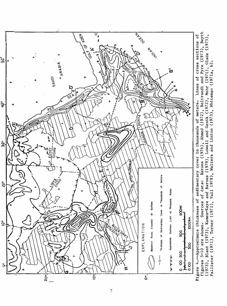
Figure 4. Approximate thickness
of sedimentary
cover
in th
ousa
nds
of me
ters
. Li
nes
of cr
oss
sections of
figu
res
5-10 are
shown.
Sources
of da
ta:
Barn
es (1976),
Ahmed
(1972),
Beltrandi
and
Pyre (1973),
Beyth
(197
3),
Blan
t (1
973)
, Ka
men-
Kaye
and
Barn
es (1979),
Lowell and Genik
(197
2),
Mohr (1
971)
, Ol
ade
(197
5),
Pall
iste
r (1
971)
, Turner (1971),
Vail
19
78),
Walters
and
Linton (1973),
Whit
eman
(1
971a
, b)
.

List of abbreviations used on figures 5-11
Q - Quaternary
T - Tertiary
Tin - Miocene
To - Oligocene
Te - Eocene
Et - Taleh Formation
Ea - Auradu Formation
Tp - Paleocene
K - Cretaceous
Ku - Upper Cretaceous
Kl - Lower Cretaceous
Kg - Gumburo Group
Kc - Cotton Formation
Km - Mustahil Limestone
Kb - Belet Wen Limestone
Kj - Jessoma Sandstone
J - Jurassic
Jg - Gabre Derre Formation
Ju - Urandab Formation
Jh - Hamanlei Formation
Ja - Adregrat Sandstone
Tr - Triassic
PC - Precambrian
S.L - Sea Level
7a
nctu-t-r «
B
MA
ND
ER
A
LU
GH
B
AS
IN
B1
i t
135
i3om
i.
Figu
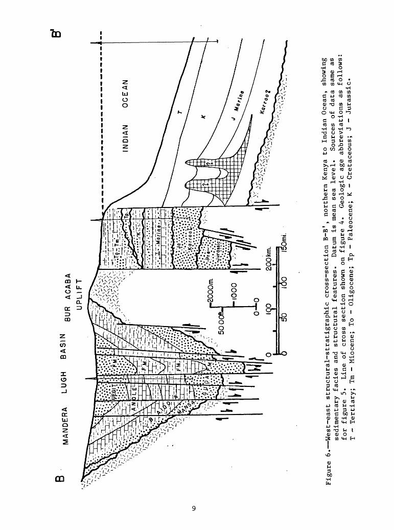
re 6. West-east structural-stratigraphic cross-section
B-B'
, no
rthe
rn Kenya to Indian Ocean, sh
owin
g se
dime
ntar
y facies and
stru
ctur
al fe
atur
es.
Datum
is mean se
a level.
Sources
of da
ta same as
for
figu
re 5.
Line
of cr
oss
section
shown
on fi
gure
4.
Geologic age
abbreviations
as follows
T -
Tert
iary
; Tm - Miocene; To -
Oligocene; Tp -
Paleocene; K -
Cretaceous;
J -
Jura
ssic
.
a continuous downwarp, and perhaps they should be considered a single basin. Possible differences are indicated by geophysical work that shows a greater extent of vertical faulting in the floor of the Mandera-Lugh Basin (Beltrandi and Pyre, 1973; Whiteman, 1981). Similarly, the Ogaden Basin tends to merge eastward with the Somali embayment, although a north-south trend of sedimentary thinning separates the two (fig. 4).
The Lamu embayment in southern Somalia and eastern Kenya appears to be a southern continuation of the Ogaden and Mandera-Lugh depressions, although geophysical work has identified an east-west basement ridge, which separates the Lamu embayment from the Mandera-Lugh Basin (Whiteman, 1981). The structural pattern of the Lamu embayment, as well as those along the Somalia coast, is obscured by flat-lying coastal-plain deposits. In the subsurface, however, geophysical work has identified northeast-southwest- trending faults and pre-Tertiary highs in the Lamu embayment (Walters and Linton, 1973; Whiteman, 1981). Salt-assisted structures also may be present. Older fault troughs of Karroo age (Carboniferous to Triassic) may be present in the basement floor of the basin, and these may extend northward into the Mandera-Lugh Basin or possibly farther.
Whiteman (1979) recognized four distinct periods of faulting in Kenya: (1) Karroo faulting (Carboniferous to pre-Middle Jurassic) - affecting the southern coastal belt of Kenya, parts of Tanzania, the Mandera-Lugh Basin, and possibly the deep part of the Lamu Basin with two major trends extending offshore; (2) latest Cretaceous faulting; (3) Oligocene faulting; and (4) Pliocene faulting.
The basins and uplifts described above occupy the Mesozoic and Tertiary continental shelf along the passive margin of east Africa adjacent to the offshore Somali Basin (Seychelles Basin of Kamen-Kaye and Barnes, 1979) in the northwestern Indian Ocean between the Horn of Africa and the Seychelles Islands (fig. !) The Somali Basin is a continental margin (extra-continental) downwarp basin (Klemme, 1980). Some question has arisen on whether or not the downwarp is an open or closed basin; whether or not the basin is closed depends on interpretation of Precambrian granites in the Seychelles Islands and Madagascar on the east side of the Somali Basin abyssal plain where oceanic crust is also present (Blant, 1973; Nairn, 1978; Kamen-Kaye, 1978; Kamen-Kaye and Barnes, 1979).
The sedimentary section in the Somali Basin is thickest along the African coastline through Kenya and Somalia (figs. 4 to 6) on the east side of a major fault system, downdropped on the ocean side and extending along the coastline southwestward at least as far as the Bur Acaba uplift and possibly through Kenya (Barnes, 1976; Kamen-Kaye and Barnes, 1979; Whiteman, 1981). Major movement on this regional fault system took place in Tertiary time, but it may have been active also as early as Jurassic time. Downthrow on the fault system is reported to be at least 4,000 m (14,000 ft) on the seaward side, where more than 9,000 m (30,000 ft) of marine and continental sediments of Tertiary, Cretaceous, Jurassic, and probably Karroo (Carboniferous-Triassic) age are preserved.
10
The Cotton Basin, Somali embayment, and Lamu embayment are shoreward extensions of regional subsidence associated with growth of the Mesozoic and early Tertiary Somali Basin. The relatively narrow belt of thick Tertiary and older sediments east of the shoreline fault system (figs. 4 and 6) was referred to as the Tertiary coastal basin by Barnes (1976) and as the Somali or Mogadishu Coastal Basin by Whiteman (1981).
Plateau and Rift Belt
The plateau and rift belt of Ethiopia and northern Kenya forms the northern part of the central plateau and rift province that extends for approximately 3,000 km (2,000 mi) from the province of Zambezia in Mozambique to the Red Sea. The belt is characterized by a broad, uplifted plateau of Precambrian crystalline rocks, largely mantled by Cenozoic volcanics, referred to as the Central Plateau or East Africa Swell south of Lake Turkana (Lake Rudolf) in northwest Kenya and as the Ethiopian-Somalian Plateau or Ethiopian Swell to the north (fig. 2). The central part of the regional plateau is cut by systems of rift valleys about 40 to 50 km (25 to 30 mi) wide, most of them trending north-northeast or north-northwest and some north-south. The main valleys are elongate and are several hundred kilometers long, but associated with them are shorter branching and en-echelon fault systems. In northwest Kenya, the regional plateaus are separated near Lake Turkana by a depression, which may have provided an ancestral connection between the depositional basins of Somalia and Kenya and those of Sudan (Holmes, 1965).
The Central and Ethiopian-Somalian Plateaus underwent several stages of uplift that began in late Mesozoic time and extended into Pliocene-Pleistocene time (Mohr, 1971). Faulting and rifting of the plateau probably occurred in Miocene and later time. The Tertiary uplift and rift system may have followed lines of weakness related to older mobile belts in east Africa, for example the Mozambique belt of late Precambrian-early Paleozoic age (Holmes, 1965; McConnell, 1972; Pilger and Rosier, 1976; Kamen-Kaye and Barnes, 1979). Volcanic activity associated with development of the plateau and rift system began as early as Late Cretaceous time and continued in several episodes through Pleistocene and Holocene time.
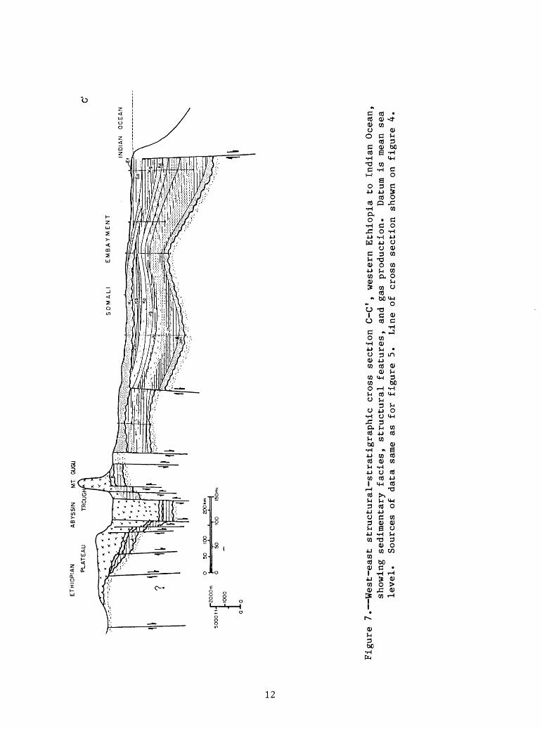
Growth of the final and major phase of the rift systems progressed from north to south, beginning in the northern part near the Red Sea in late Oligocene to early Miocene time and becoming progressively younger to the south, mainly of Miocene and younger age in the main Ethiopian rift system and the Central plateau and rift system to the south (Pilger and Rosier, 1976). During development of the rift systems, basaltic and other volcanic flows and tuffs as much as 2,000 m (6,500 ft) or more in thickness accumulated along the central rifted part of the Ethiopian plateau (fig. 7). The floors of the rift blocks apparently are underlain by relatively flat-lying Mesozoic marine sediments. Fault displacement along the grabens 1 borders may be as much as 1,000 to 2,000 m (3,000 to 7,000 ft) in some cases (fig. 7).
11
ETHI
OPI
AN
ABYS
SIN
Ml
GUGU
PL
ATEA
U TR
OUG;
C'
EM
BA
Y W
EN
T
IND
IAN
O
CE
AN
0
50
100
20
0km
I '
. '
'.
' I
Figu
re 7. West-east st
ruct
ural
-str
atig
raph
ic cr
oss
section
C-C
1, we
ster
n Ethiopia to Indian Ocean,
show
ing
sedimentary
facies,
structural fe
atur
es,
and
gas
prod
ucti
on.
Datum
is mean sea
leve
l.
Sources
of da
ta sa
me as fo
r fi
gure
5.
Li
ne of cr
oss
sect
ion
show
n on
figure 4.
Red Sea and Gulf of Aden Basins
The northern part of the Africa-Middle East plateau and rift belt is occupied by the Red Sea and Gulf of Aden Basins and the smaller depressions of the Suez, Gulf of Aqaba, and Dead Sea farther north.
The pre-rift growth of this region took place in latest Cretaceous and early Tertiary time. The Red Sea and Gulf of Aden areas may have been depressed during Jurassic and Cretaceous time (Whiteman, 1968), but the main subsidence of the grabens probably began in the early Tertiary. Uplift and arching of the African-Arabian shield culminated near the close of Eocene time; widespread volcanism occurred; and the African-Arabian shield began to spread apart, resulting in the initial Red Sea rift (Lowell and Genik, 1972). Sea-floor spreading followed, and vertical faulting with displacements of several thousand meters ultimately occurred on both sides of the rift (figs. 2 and 8). This activity continued through Oligocene time, and by early Miocene time the Red Sea margins essentially had attained their present form, although sea- floor spreading, volcanism, and sedimentary infilling have continued to the present. The Gulf of Aden followed a sequence of events similar to that of the Red Sea, but the initiation of rifting was later than that of the Red Sea.
The present-day structure of the Red Sea Basin is that of a deep rift complicated by extensive faulting of the floor and overlying sediments, draping of sediments over fault blocks, and a complex of salt structures (fig. 8).
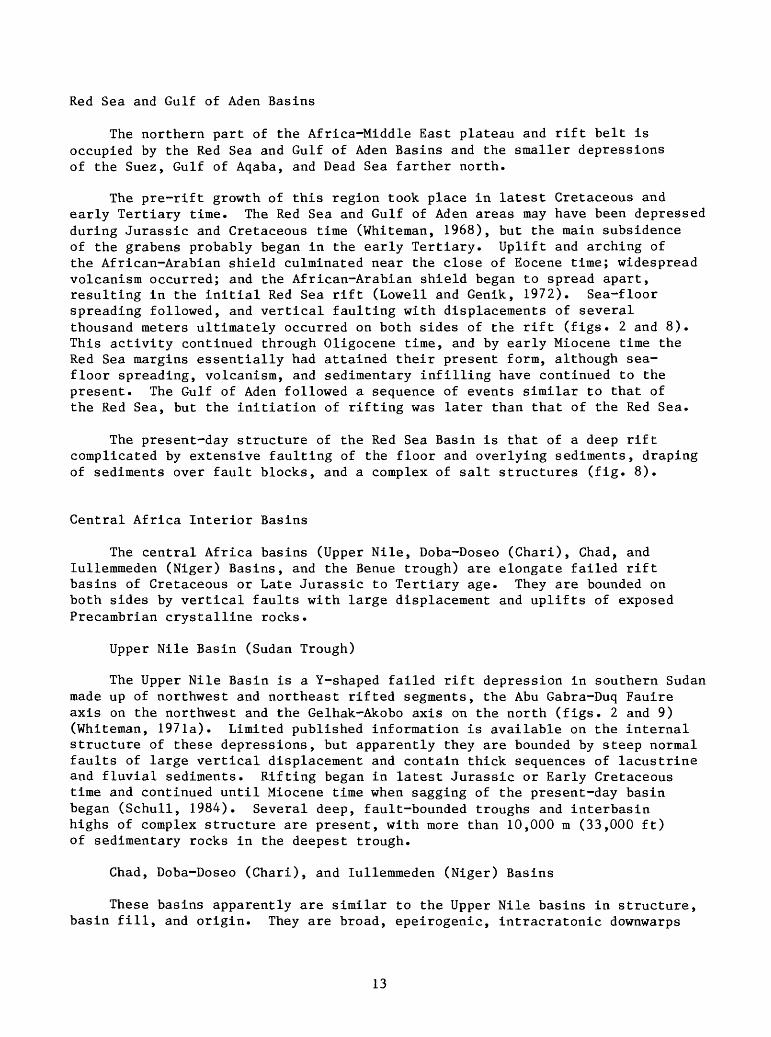
Central Africa Interior Basins
The central Africa basins (Upper Nile, Doba-Doseo (Chari), Chad, and lullemmeden (Niger) Basins, and the Benue trough) are elongate failed rift basins of Cretaceous or Late Jurassic to Tertiary age. They are bounded on both sides by vertical faults with large displacement and uplifts of exposed Precambrian crystalline rocks.
Upper Nile Basin (Sudan Trough)
The Upper Nile Basin is a Y-shaped failed rift depression in southern Sudan made up of northwest and northeast rifted segments, the Abu Gabra-Duq Fauire axis on the northwest and the Gelhak-Akobo axis on the north (figs. 2 and 9) (Whiteman, 1971a). Limited published information is available on the internal structure of these depressions, but apparently they are bounded by steep normal faults of large vertical displacement and contain thick sequences of lacustrine and fluvial sediments. Rifting began in latest Jurassic or Early Cretaceous time and continued until Miocene time when sagging of the present-day basin began (Schull, 1984). Several deep, fault-bounded troughs and interbasin highs of complex structure are present, with more than 10,000 m (33,000 ft) of sedimentary rocks in the deepest trough.
Chad, Doba-Doseo (Chari), and lullemmeden (Niger) Basins
These basins apparently are similar to the Upper Nile basins in structure, basin fill, and origin. They are broad, epeirogenic, intracratonic downwarps
13
5000ft-
0-*
-0
SU
DA
NR
ED
S
EA
SA
UD
I A
RA
BIA
D'
Figu
re 8. West-east structural-stratigraphic cr
oss
section
D-D
f, southern Re
d Sea
depression,
showing
sedimentary
faci
es,
stru
ctur
al features,
and
gas
disc
over
ies.
Datum
is mean se
a le
vel.
Sources
of da
ta:
Lowe
ll an
d Genik
(1972) and
Ahmed
(1972).
Line of cr
oss
sect
ion
show
n on fi
gure
4.
Geol
ogic
age
abbr
evia
tion
s as follows:
Q -
Quat
ernary;
Tm - Mi
ocen
e;
Te -
Eocene;
K -
Cretaceous;
J -
Jura
ssic
.
characterized by buried rifts in the basin floor associated with Mesozoic spreading and opening of the south Atlantic Ocean (Fetters, 1981) (figs. 2, 9, and 10). The Doba-Doseo Basin trends east-west in southeastern Chad and the northern part of the Central African Republic. The central depression of the Chad Basin trends northwest-southeast in west-central Chad and southeast Niger. The central depression of the lullemmeden Basin has a north-south trend and is located along the border between northwest Niger and Mali. These basins, along with the Upper Nile basins, form a network of rifted intracontinental basins that extend across Africa and have generally similar structural and depositional histories.
The small Sokoto Basin, a southern arm of the lullemmeden Basin (fig. 2), contains a generally undisturbed section of relatively thin (about 1,000 m or 3,300 ft) Upper Cretaceous to Eocene beds, part of which are marine (Fetters, 1979a, b).
The Bornu Basin, which is a southwest arm or sub-basin of the Chad Basin, contains a deep (greater than 3,000 m or 10,000 ft) northeast-southwest trough (fig. 4) having several smaller basement ridges and lows at angles to the main trough, which are thought to be a result of rifting or folding in latest Cretaceous time (Turner, 1971b).
Benue Trough
The Benue trough is a rifted craton-edge basin or aulacogen, open on the southwest into the Niger Delta Basin (figs. 3 and 11). Development of the Benue trough is thought to have begun with middle Cretaceous (Albian-Aptian) rifting and spreading probably associated with the opening of the south Atlantic Ocean (Turner, 1971b; Weber and Daukoru, 1975; Burke and others, 1972). These authors interpreted this depression as a rift valley originating under tensional stresses in middle Cretaceous time, followed by volcanism and infilling of the trough by latest Cretaceous time, after which compressional stresses caused folding of the Cretaceous beds (Turner, 1971a, b). The small Nupe Basin (fig. 2), a narrow northwest-trending arm of the Benue trough, is a probable rift basin which contains a thin section of relatively undisturbed uppermost Cretaceous clastic deposits (Turner, 1971b). The Niger Delta Basin, which adjoins the Benue trough on the southwest, is primarily a Tertiary basin with 10,000 m (33,000 ft) or more of fill mainly of post-Paleocene age (figs. 2, 3 and 11).
Stratigraphy
The sedimentary cover of central Africa is confined to a series of isolated large rift basins containing mainly Mesozoic and Tertiary continental deposits, except for the Benue trough, which contains thick marine and conti nental sediments mainly of Late Cretaceous age (figs. 3 and 4). The continental basins are limited on the east by the Ethiopian plateau and rift valley province, where the Precambrian basement is exposed in broad, high plateaus. In this region, the rift valleys and adjacent areas are covered by thick volcanics of Late Cretaceous to Holocene age that are underlain by a thin section of Jurassic and Cretaceous marine and continental carbonate and
15
clastic beds. The Red Sea Basin to the north contains as much as 5,000 m (15,000 ft) or more of middle and late Cenozoic clastic, carbonate, and evaporite deposits. To the east of the plateau and rift valley province, the coastal basins of east-central Africa contain thick marine deposits and some continental deposits along the western shelf of the Somali Basin or the eastern passive margin of Africa (figs. 2, 5, 6, and 7).
Precambrian
Precambrian crystalline and igneous rocks are exposed in many uplifted regions of the African craton and form the basement rocks of the central and east-central Africa basins. Published works on Precambrian geology in central and east Africa include those by Holmes (1965), Anhaeusser and others (1969), Pallister (1971), Turner, (1971a, b), Choubert and Faure-Muret (1971a, b), Tanner (1973), Kroner (1977), Vail (1978), El-Raba'a (1978), and Engel and others (1980).
The thick section of late Precambrian sedimentary rocks present in the Taoudeni Basin of western Africa thins eastward and is not reported east of approximately longitude 5° E. Thus, these rocks probably are not present in the subsurface of the central Africa basins, except for possible remnants in the western part of the lullemmeden Basin.
Paleozoic
During most of Paleozoic time, the interior of the African continent was largely emergent, and Paleozoic rocks are reported to be generally absent in the subsurface of the central African basins, although part of the basal beds overlying basement could be of probable late Paleozoic age (Fetters, 1979a, b, 1981). The extensive Paleozoic deposits of the north African Sahara platform are absent south of a line running through southern Egypt, northern Sudan, central Chad, and northern Niger (fig. 4). Coarse clastic rocks of Carboniferous, Permian-Triassic, and perhaps Early Jurassic age are present in the Karroo facies of southeastern and eastern Africa, which extends north ward into Kenya and possibly southern Ethiopia and southwest Somalia (figs. 5 and 6). In the subsurface of the African coastal basins bordering the Indian Ocean north of Madagascar, the Karroo continental coarse clastic facies is interbedded with marine fine clastic rocks and evaporites, including salt of Permian-Triassic age. The evaporite beds may extend north as far as the Mandera-Lugh Basin in northern Kenya and southwestern Somalia (figs. 5, 6, and 12).
The Nubian sandstone facies of the African Sahara, which extends south ward into northern Sudan and northern Ethiopia, is probably present in the subsurface in parts of the Red Sea Basin, Afar depression, and northernmost Somalia. In Egypt and Libya, the Nubian contains beds of probable Carboniferous age, some of which may be present in the Nubian beds of east- central Africa. Sandstones of Ordovician age also are reported in northern Ethiopia (Beyth, 1973).
19
\J
Sudan
K.
IM.Y.
\ N
\
EXPLANATION
Main Sedimentary, Facies
I Oolitic and fossiliferous carbonate
Anhydritic-gypsiferous
"irJn}! Marine shale
Mixed marine carbonate and clastic
0 300mi.Ir^> I0 500km.
'Somalia
JURASSIC
Figure 12. Approximate thickness of Jurassic sedimentary rocks in thousands of meters, partly restored, with main sedimentary facies shown. Sources of data same as for figure 5. Cities shown - SUDAN: (NY) Nyala, (K) Khartoum, (P.S.) Port Sudan - ETHIOPIA: (A.A.) Addis Ababa - SOMALIA: (M) Mogadishu - KENYA: (N) Nairobi.
20
Mesozoic
Mesozoic rocks are present in all of the main central and east African basins but represent a wide range of depositional environments, including shelf carbonate and clastic beds of Jurassic and Cretaceous age in Somalia and Ethiopia, deep-water marine clastic and evaporite beds in Kenya, continental fluvial-lacustrine beds in the central Africa interior basins, and marine elastics in the Benue trough.
East-central Africa
Jurassic
Rocks of Jurassic age are present in all of the east-central Africa basins in Somalia, Kenya, and Ethiopia (fig. 12). These rocks represent a primarily marine carbonate and fine clastic facies deposited on the western shelf of the Somali Basin, which may be a southern arm of the Mesozoic Tethyan Middle East Arabian Basin. This facies reaches a western zero edge that runs approximately north-south in central Ethiopia (figs. 7 and 12). Thickness is approximately 1,000 to 4,000 m (3,000 to 13,000 ft) in Somalia, eastern Ethiopia, and eastern Kenya but is less than 300 m (1,000 ft) on the Nogal uplift and in the vicinity of the Bur Acaba uplift (figs. 5 and 12).
The basal Jurassic unit (Adigrat Sandstone), ranging from less than 25 m (80 ft) to more than 100 m (325 ft) thick, represents the initial deposits of the widespread Tethyan marine transgression of the east African and Arabian shelf. This unit is probably latest Triassic and Early Jurassic age in the coastal basins of Somalia and is younger to the northwest, becoming uppermost Jurassic in age near its western limits in central Ethiopia where it grades upward into sandstone beds of Early Cretaceous age. To the south, in the Mandera-Lugh Basin and Lamu embayment, the Adigrat probably merges into the upper part of the Karroo facies or the Mansa Guda Formation (Figs. 5 and 6). In the shelf area, the Adigrat grades upward into the Hamanlei Formation (Antalo Limestone of northern Ethiopia), primarily a Tethyan marine shelf carbonate facies of Middle and Upper Jurassic age (figs. 5 and 7). The Hamanlei is composed of fossiliferous limestone, some gray shale, and minor amounts of siltstone or fine sandstone. Oolitic and coralline limestone beds are present in southern Somalia and parts of Ethiopia, and anhydrite is interbedded with dolomite and limestone in northern Somalia. The carbonates become more shaly and are interbedded with dark gray marine shale in the Somali embayment and the Mandera-Lugh Basins and Lamu embayment (figs. 5 to 7). The Hamanlei Formation ranges in thickness from less than 300 m (1,000 ft) to more than 2,000 m (6,500 ft) in Somalia and eastern Ethiopia and thins and becomes more sandy to the west toward the depositional limit in Ethiopia.
The Hamanlei Formation is overlain by the Late Jurassic Uarandab Formation, a marine unit primarily of marly or shaly limestone and gray shale. Gypsum beds also are present in northern Somalia and in eastern Ethiopia. The upper most Jurassic is represented by the Gabre Darre Formation, a marine gray shale and limestone unit less than 25 m (80 ft) to about 500 m (1,600 ft) thick that is widely distributed in Somalia and eastern Ethiopia.
21
Cretaceous
The Jurassic-Cretaceous boundary is unconformable in parts of the Horn of Africa (Somalia, eastern Ethiopia, and Kenya), particularly in the vicinity of major uplifts such as the Nogal and Bur Acaba highs and to the west in Ethiopia (figs. 5 and 7). In basinal areas such as the Lamu embayment and the Mandera-Lugh and Ogaden Basins, however, the unconformity may be absent or greatly diminished (Kamen-Kaye and Barnes, 1979). Further evidence of regression at the close of the Jurassic is represented by the presence of extensive deposits of gypsum or anhydrite (Main Gypsum) in the uppermost Jurassic- Lower Cretaceous section in eastern Ethiopia and parts of northern Somalia (figs. 5, 7, and 13). In coastal Somalia, Lower Cretaceous beds are primarily shaly limestone and limestone, some of which is reefoid (Cotton and Garba Harre Formations). In the Lamu embayment, Lower Cretaceous rocks are primarily marine gray shale and shaly limestone underlain by sandstone and shale beds, which also may be of Early Cretaceous age (fig. 5).
Rocks of Late Cretaceous age are represented by the Gumburo Group in Ethiopia and Somalia and by marine shale, sandstone, and minor limestone in the Lamu embayment in Kenya (figs. 3 and 5-7). The lower unit of the Gumburo is a marine sequence of marly limestone and shale (Mustahil Limestone) that contains lenticular rudist reefs; it seems to be best developed in the vicinity of the Bur Acaba uplift and is not distinguishable in all places in the subsurface (Barnes, 1976). The Mustahil is gypsiferous in the upper part and grades into the overlying Ferfer Gypsum Formation on the north flank of the Bur Acaba uplift. Elsewhere in Somalia and eastern Ethiopia, the Upper Cretaceous section comprises the undifferentiated Gumburo Group, which is primarily marine fossiliferous limestone, reefoid in places, and dark gray marine shale. To the south, rocks of Late Cretaceous age are primarily marine shale with minor limestone. In the vicinity of the Bur Acaba uplift and extending northwestward into Ethiopia, a tongue of the Gumburo limestone and gray shale facies (Belet Wen Formation) is overlain by the Jesomma Sandstone of latest Cretaceous to Paleocene age.
Rocks of Cretaceous age are approximately 1,000 to 1,500 m (3,000 to 5,000 ft) thick along the Somalia coastal belt and thin westward and northward to less than 500 m (1,600 ft) in much of eastern Ethiopia. In southern and eastern Kenya, 3,000 m (10,000 ft) or more of Cretaceous rocks are present.
Tertiary
In Somalia and eastern Ethiopia, Tertiary rocks are represented by the upper part of the Jesomma Sandstone and the Auradu, Taleh, and Karkar Formations of Paleocene and Eocene age. The Jesomma Sandstone is of latest Cretaceous and Paleocene age (Kamen-Kaye and Barnes, 1979) and is widely distributed in eastern Ethiopia and central Somalia (figs. 3 and 7). The Auradu of Paleocene and early Eocene age is a marine fossiliferous limestone unit as thick as 500 m (1,600 ft) or more in northern Somalia but changes to a deeper water facies of marine shale and argillaceous limestone to the east and southeast in Somalia. The Auradu is overlain by a sequence of interbedded gypsum, limestone, and shale (Taleh Formation), which changes eastward and northward to primarily dolomite and to the south and southeast to sandstone, red and green shale,
22
X..J
.--J
\
da / Kenya
0 300mi. CRETACEOUS. . .
0 ' ' : 500km.
Figure 13. Approximate thickness of Cretaceous sedimentary rocks in thousands of meters, partly restored, showing main sedimentary facies. Sources of data same as for figure 5.
23
gypsum, and limestone. The Karkar Formation, overlying the Taleh Formation, consists of limestone, gypsum, and shale in northern Somalia and changes to sandstone and varicolored shale toward the southeast.
Post-Eocene sedimentary rocks generally are absent in northern Somalia and eastern Ethiopia but are present in east-central and southeast Somalia along the coastline, where they are represented by 1,000 m (3,300 ft) or more of marine sandstone, shale, and limestone in the Lamu embayment. Rocks of Tertiary age are approximately 500 to 1,000 m (1,600 to 3,300 ft) thick in most of Somalia north of the Bur Acaba uplift and reach thicknesses of 3,000 to 5,000 m (10,000 to 16,000 ft) in parts of the Lamu embayment to the south (figs. 5, 6, 7, and 14).
Tertiary sedimentary rocks generally are absent or very thin in the vicinity of the Bur Acaba uplift and in Ethiopia approximately west of 45° E except for beds of probable early Tertiary age in the upper part of the Jesomma Sandstone. A substantial amount of the lower Tertiary section may have been removed by post-Eocene uplift and erosion on the Somalia-Ethiopia shelf so that complete sections of Tertiary rocks are present only along the Somalia coast, in the Lamu embayment, and in the offshore areas of the Somali Basin.
In central Ethiopia, Tertiary rocks are primarily of volcanic origin associated with growth of the rift valley system. As much as 2,000 m (6,500 ft) or more of basaltic and other volcanic flows, tuffs, and tuffaceous sediments are preserved in highlands bordering the rift valleys. The volcanic rocks are probably interbedded with continental and lacustrine tuffaceous sediments in the subsurface of the rift valleys.
Tertiary rocks exposed in the Afar depression, which adjoins the southern Red Sea and Gulf of Aden Basins, are primarily Pliocene-Pleistocene fluvial and lacustrine gravels, sands, clays, tuffs, and other volcanic rocks and some lacustrine limestones or marls (Taieb, 1975; Kursten, 1975) as thick as several hundred meters. These rocks intertongue northward with Pliocene- Pleistocene evaporitic beds 1,000 m (3,300 ft) or more thick (Danakil Formation and basalt of Hutchinson and Engels, 1972).
As much as 5,000 m (16,000 ft) or more of Oligocene and younger Tertiary marine and continental clastic, evaporite, and carbonate sediments are present in the Red Sea Basin (figs. 8 and 14) (Lowell and Genik, 1972; Ahmed, 1972). Oligocene and lower Miocene rocks consist primarily of continental and marine sandstone and shale, in places interbedded with volcanic rocks. Near the center of the Basin, middle and upper Miocene rocks are mainly evaporites and fine elastics that include thick deposits of salt and grade westward to marine sandstone and siltstone, shale, and Globigerina marl. Upper Miocene- Pliocene beds (Desset series) are primarily marine elastics with coral reefs overlain by Quaternary evaporites (including salt) and marine elastics.
24
EXPLANATION
Basement
Main Rock Facies
Sandy
Anhydrit i c- gypsiferous
Mixed continental and marine clasticyx
and carbonate
0 300mi.I * -,I ; : i
500km.
TERTIARY
Figure 14. Approximate thickness of Tertiary sedimentary rocks in thousands of meters, partly restored, showing main sedimentary facies and volcanic rocks. Sources of data same as for figure 5.
25
Central Africa Interior Basins
Limited information is available on the internal stratigraphy of the central Africa interior basins (Upper Nile, Doba-Doseo (Chari), Chad, and lullemmeden (Niger) Basins). Wells drilled in these basins have penetrated a sedimentary section 3,000 to 4,000 m (10,000 to 13,000 ft) or more thick, reportedly mainly continental and lacustrine elastics of Cretaceous and Tertiary age, little of which is exposed in outcrops on basin borders. Most of the stratigraphic section apparently is of Cretaceous age. Sedimentary thickness is 6,000 m (20,000 ft) or more in the main rift troughs. The basal part of the section may be of Jurassic or earlier age, and rocks probably of Carboniferous and Devonian age are reported in a well drilled in the northwest part of the lullemmeden Basin (Fetters, 1981). On the southeast border of the lullemmeden Basin, an outcropping sequence of Late Jurassic, Cretaceous, and early Tertiary age contains marine clastic and carbonate rocks of latest Cretaceous and Paleocene age (Fetters, 1979a, b), which is also present in the basin interior. The basal unit (Damergou sequence) is composed of conglomerate, sandstone, and clay of Late Jurassic and Early Cretaceous age (Gundumi and Illo Formations of northwest Nigeria, "Continental Intercalaire" of southwest Niger) that is also present in the Chad Basin. The basal clastic unit is overlain by the Ajaouk sequence, a Late Cretaceous (Maestrichtian) marine cycle of sandstone, siltstone, and mudstone with some lignite (Taloka Formation), overlain by mudstone, gypsiferous shale, and marl (Dukamaje Formation). The Maestrichtian cycle is overlain by beds of the Paleocene marine cycle, which in ascending order consist of the Wurno Formation (silt- stone, fine sandstone and carbonaceous mudstone), the Dange Formation (marine phosphatic shale), and the Kalambaina Formation (marl and phosphatic shale). On the outcrop, the Paleocene cycle is overlain by continental beds of clay and sandstone (Gwandu Formation or Dosso sequence) of Eocene age.
A somewhat similar sequence is present in the southwest part of the Chad Basin (Fetters, 1979a, 1981) where the basal continental redbed unit (Damergou sequence or "Continental Intercalaire") is approximately 2,000 m (6,500 ft) thick in the graben floor of the basin and thins to 1,000 m (3,300 ft) or less on the basin borders. These beds are mainly of Early Cretaceous age; the basal part may be partly of Permian to Jurassic age. The overlying Ajaouak sequence (Late Cretaceous-Paleocene) of marine and continental sandstone, siltstone, green and gray shale, and some limestone is approximately 1,000 m (3,300 ft) thick. The post-Paleocene Dosso sequence consists of approximately 400 m (1,300 ft) to 600 m (2,000 ft) of coarse fluvial sandstone and lacustrine clay beds. Detailed descriptions of the lithology, fossil content, and distribution of these units are given by Fetters (1979a, b, 1981).
Limited information is available on the subsurface geology of the Upper Nile Basin. Wells drilled in the basin interior are reported to have penetrated a continental and lacustrine clastic section approximately 4,000 m (13,000 ft) thick of Cretaceous and Tertiary age similar in lithology to that of the Chad and Doba-Doseo Basins. Most of the stratigraphic section is Cretaceous in age and consists of lacustrine, fluvial, alluvial, and floodplain sandstone, conglomerate, and shale. In much of the basin, 6,000 m (20,000 ft) or more of sedimentary rocks are present, and the deepest trough contains more than
26
10,600 m (35,000 ft) (Schull, 1984). Organic-rich lacustrine shales of Aptian- Albian age are present in the central parts of the basin. Rocks of late Paleozoic age, mainly sandstone, are present at outcrop localities in parts of Sudan, particularly to the north, and could be present in the floor of the Upper Nile Basin. The Gedaref and Eritrean sandstone of Jurassic age and the Yirol Formation (sandstone, shale and conglomerate) of latest Jurassic-Early Cretaceous age crop out near the borders of the Upper Nile Basin (Whiteman, 197la, b). Equivalents of these beds also may be present in the basin sub surface. Outcropping rocks of Tertiary age in the vicinity of the Upper Nile Basin are represented by the Hudi Chert of lacustrine origin, equivalents of which may make up much of the relatively thick Tertiary section in the sub surface. Late Tertiary and Pleistocene deposits in central and southern Sudan are represented by the Uum Ruwaba Formation gravel and sand beds, which may be as thick as 500 m (1,600 ft) or more in downfaulted depressions (Setlow, 1982). Lake Sudd, a proposed Pleistocene lake, was believed by some authors to have occupied parts of the area of the Upper Nile Basin (Whiteman, 1971a, b).
Benue trough
The Benue trough contains more than 6,000 m (20,000 ft) of clastic and carbonate marine and continental rocks of late Early Cretaceous through Cenozoic age (figs. 3, 4, and 11). As much as 3,000 m (10,000 ft) of late Early Cretaceous (Albian) arkosic and quartzose sandstones, marine shale, and limestone (Asu River Group) overlie Precambrian basement rocks in the trough (Albian depositional cycle) (Petters and Ekweozor, 1982). The Asu River beds beds are overlain unconformably by gray and black marine shale, limestone, and sandstone of the early Late Cretaceous Cross River Group, which is as thick as 2,000 m (6,500 ft). In the southwest part of the trough, near the Niger delta, the Cross River Group is overlain unconformably by nearshore marine and deltaic-fluvial sandstone, gray shale, and coaly beds of latest Cretaceous and early Tertiary age.
The Benue trough is separated by the Zambuk ridge (figs. 2 and 11) from the southeast part of the Chad Basin (Bornu subbasin), which contains a sequence of about 2,000 m (6,500 ft) of Lower and Upper Cretaceous sandstone, dark gray shale, and minor limestone, part of which is marine, and Cenozoic clastic deposits (Petters and Ekweozor, 1982). The southwest part of the Benue trough merges into the prolific Niger Delta petroleum province where at least 10,000 m (33,000 ft) of Cenozoic deltaic and alluvial sediments were deposited by an ancestral Niger River.
PETROLEUM GEOLOGY
Until recent years, petroleum exploration in central and eastern Africa has centered largely on the Horn of Africa (Somalia, eastern Ethiopia, and eastern Kenya), where a thick marine sedimentary section is present, similar in some respects to that of the prolific Arabian Basin petroleum province to the north. Active exploration programs in the Horn of Africa began shortly after World War II, and by 1982 approximately 50 exploratory wells had been drilled in Somalia, 17 in Kenya (Whiteman, 1981), and 20 in eastern Ethiopia
27
(fig. 1). Most of these were drilled to depths less than 3,000 m (10,000 ft), but at least 25 were drilled deeper. The deepest well (4,925 m) (16,023 ft) is the Sinclair No. 1 Obbia on the central Somalia coast. Thus far, despite several indications of hydrocarbons, no commercial oil or gas discoveries have been made in the Horn of Africa region, with the possible exception of the Calub well in eastern Ethiopia, reported as a possible gas discovery (fig. 1) (Kamen-Kaye and Barnes, 1979).
Exploration activity in the central Africa interior basins began in the middle 1970's, and since that time several oil fields have been discovered in the Upper Nile, Doba-Doseo, and Chad Basins (figs. 1, 2, 9, and 10). Production in these fields is from continental and lacustrine sandstone reservoirs of Cretaceous and Tertiary age. No discoveries have been made in the lullemmeden Basin, the Benue trough, the Red Sea Basin, or the Gulf of of Aden Basin. Most of the central Africa basins subsided in Jurassic, Cretaceous, and Tertiary time, as shown by unconformities in the vicinity of the flanking uplifts and thickening of the sedimentary cover in the basins (figs. 4, 9, and 10).
Information on petroleum geology for this report was acquired from several sources, including publications by Barnes (1976), Kamen-Kaye and Barnes (1979), Whiteman (1981), Weber and Daukor (1975), Fetters and Ekweozor (1982), Agagu and Ekweozor (1980), articles from The Oil and Gas Journal and World Oil, and the information files of Petroconsultants, S.A.
Somali Basin
Most of the Horn of Africa is covered by carbonate, clastic, and evaporite sedimentary rocks of Mesozoic and Cenozoic age that were deposited on the east African passive margin. Much of the section is made up of (1) shallow-water marine limestone and dolomite and (2) quartzose nearshore sandstones of Middle and Upper Jurassic, Cretaceous, and early Tertiary age, which change eastward to deeper-water argillaceous carbonate, fine sandstone or siltstone, and shale in the deeper part of the Somali Basin (figs. 6 and 7). Gypsum or anhydrite is present in parts of the western shelf.
The northwest Somali Basin shelf assessment region covers an area of about 1,300,000 km2 (530,000 mi 2 ), including the offshore area to 1,000 m (3,300 ft) water depth, and contains approximately 5,000,000 km3 (1,200,000 mi3 ) of Mesozoic and Cenozoic sedimentary cover. The sedimentary wedge thickens from less than 1,000 m (3,300 ft) in parts of Somalia and eastern Ethiopia to more than 5,000 m (16,000 ft) in the Lamu embayment and Mandera-Lugh Basin and in the coastal and offshore areas of Somalia (figs. 4 to 7). Tectonic develop ment, continuing since late Paleozoic (Karroo) time, has resulted in separation of the region into several large uplifts and sedimentary basins or troughs, which have been described in detail by Barnes (1976), Kamen-Kaye and Barnes (1979), and Whiteman (1981). The more important of these are the Bur Acaba, Nogal, and Northern uplifts; the Cotton, Ogaden, Mandera-Lugh, and Mogadishu (Tertiary coastal) Basins; and the Lamu embayment (fig. 2). South of the Bur Acaba uplift, Cretaceous and early to late Tertiary marine and coastal marine gray shale and coaly beds are of interest, primarily as possible source rocks and also reservoirs for gas.
28
Reservoirs
Carbonate and sandstone rocks with good reservoir properties are present in several parts of the sedimentary column. In Somalia and eastern Ethiopia, the basal Jurassic Adigrat Sandstone up to several hundred meters thick is porous at several well locations, as is the underlying Karroo sandstone and conglomerate facies where drilled in the Mandera-Lugh Basin. The thick Jesomma Sandstone of latest Cretaceous and Paleocene age contains porous quartzose sandstone beds in eastern Ethiopia and central to northern Somalia. Large thicknesses of porous limestone and equivalent dolomitized beds are present in the Middle Jurassic Hamanlei Formation oolitic-fossiliferous facies and the fossiliferous-reefoid facies of the Upper Cretaceous Gumburu Group, both of which are widespread in Somalia and eastern Ethiopia (figs. 5, 6, 13, and 14). Porous limestone and dolomite beds are present in the upper Tertiary section in the coastal and offshore regions of Somalia. South of the Bur Acaba uplift, rocks of known or potential reservoir quality are mainly sandstone beds of Cretaceous and Tertiary age and Miocene carbonate beds.
Source rocks
Geochemical data on source-rock quality is not available, but the stratigraphic and sedimentary environmental characteristics of the rock section and the presence of numerous indications of oil and gas, including at least one important oil seep (Barnes, 1976; Kamen-Kaye and Barnes, 1979), suggest that some source rocks should be present. In Somalia and eastern Ethiopia, rocks of potential source-rock quality include marine gray shale and argilla ceous limestone in the Jurassic, Cretaceous, and lower Tertiary sections, particularly those associated with shelf-deposited back-reef or evaporitic facies (figs. 5-7 and 12-14). Inadequate maturation and depth of burial probably are important aspects affecting source-rock quality in parts of eastern Ethiopia and Somalia. In the Mandera-Lugh Basin, Lamu embayment, and Tertiary coastal basins, much of the Tertiary section probably is gas prone, and much of the potentially favorable Mesozoic section is buried deeply enough to be in the gas window.
Seals
Widespread shale and evaporite beds of Jurassic, Cretaceous, and Tertiary age provide adequate regional and local seals.
Traps
Regional and local structures are common, including normal faults, anti clinal draping over buried and rejuvenated basement blocks, possible salt or shale swells, and igneous intrusives. Compressional folding generally is absent, and most faults are associated with late Paleozoic and Neogene tensional processes. According to Barnes (1976) and Kamen-Kaye and Barnes (1979), most of the wildcats in central and northern onshore Somalia have been drilled on identified or suspected anticlinal structures without success. However, closure identification also may have been a serious problem. Probable
29
stratigraphic pinchout and variations of porosity in fossiliferous-reefal carbonate facies and nearshore marine or deltaic sandstone beds have not been adequately explored and are important considerations for future exploration, along with greater attention to older structures (Barnes, 1976; Kamen-Kaye and Barnes, 1979; Whiteman, 1981). Many structures may be related to Neogene tensional movements and spreading associated with origin of the Red Sea and Gulf of Aden Basins. Time of generation and migration of hydrocarbons in relation to structural history thus are important considerations.
Estimated resources
USGS estimates of undiscovered petroleum resources are approximately 3.8 billion barrels of oil (BBO) and 18.6 trillion cubic feet (Tcf) of gas (figs. 15 and 16; tables 1 and 2).
Plateau and Rift Belt
The thick cover of Cenozoic volcanic rocks present in the plateau and rift belt has prevented active exploration for petroleum in this province. Adequate reservoir beds and possibly beds of potential source-rock quality may be present in the Jurassic and Cretaceous marine section underlying the volcanics. However, the severe faulting and the high temperature gradients associated with rifting and volcanic activity are strongly negative aspects. The possibility of preserved gas accumulations is of interest, but overall the region is one of very high exploration risk.
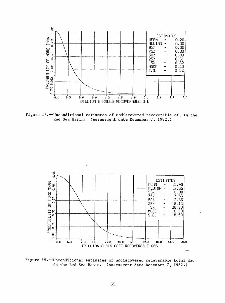
Red Sea Basin (western half)
The Red Sea Basin contains a thick section (5,000 m (16,000 ft) or greater) of Miocene and later marine and continental clastic, carbonate, and evaporite facies (figs. 3, 4, 8, and 14) deposited concurrently with the spreading and Neogene opening of the Red Sea. The western shelf includes an area of approximately 335,000 km2 (125,000 mi 2 ) extending offshore to 1,000 m (3,300 ft) water depth, with a sedimentary cover of approximately 520,000 km-^ (125,000 mi-^). Approximately 25 exploratory wells have been drilled along and offshore of the western Red Sea coast in Ethiopia and Sudan, with no success to date except for possible gas discoveries at Agip Durwara No. 2, Total Bashayer No. 1, 1A, Chevron Suakin No. 1 in Sudan; and the Mobil C-l in Ethiopia, plus indications of gas in many other exploratory wells. Major deterrents are excessively high-temperature gradients and the complicated structural history associated with Neogene rifting and spreading and salt flowage. The region is highly gas prone probably because of high temperature gradients and the humic nature of potential source rocks.
Reservoirs
Rocks with adequate reservoir potential are present in nearshore marine and fluvial sand bodies of Oligocene, Miocene, and Pliocene age and possibly
30
(CDCc-
UJa;
o >-
en(Hen o a: n.
0
to u>o
ir>0
<r- - too
t^.
o
0o o
"\
\v\
x- -^__ __
ESTI MEflN MEDIflN - 95X 75X 50X 25X
5X MODE 5.0.
NflTES 3.02 3.35 0.00 1.39 3.35 5.55 9.00 2.92 3.23
0.0 2.0 1.0 6.0 Q.O 10.0 12.0 H.O
BILLION OflRRELS RECOVERABLE OIL16.0 20.0
Figure 15. Unconditional estimates of undiscovered recoverable oil in the Somali Basin. (Assessment date December 7, 1982.)
1 d"
LJ 0£
oLi- 0
PROBflBILI0.0 0.2 0 , . , i ...
X
0.0 8
\\\
,
V"^- ^
- _
ESTI MEflN MEDIflN - ^'/. 757. 5W. 2^'L
^'/. MODE S.D.
.0 16.0 24.0 32.0 40.0 48.0 50. 0 64.0
TRILLION CUBIC FEET RECOVERABLE GflS
MflTES 10.61 16.57 3.05
10.30 16.57 24-. 56 40.30 12.90 11.50
72.0 80.0
Figure 16. Unconditional estimates of undiscovered recoverable total gas in the Somali Basin. (Assessment date December 7, 1982.)
31
Table 1. Assessment of undiscovered conventionally recoverable petroleumresources of central and east-central Africa (Niger, eastern Nigeria, Chad, Central African Republic, Sudan, Ethiopia, Somalia, and southeast Egypt). Resource assessment by USGS as of December 7, 1982; see also figures 15 through 26.
Region (fig. 1)
Crude oilin billions of barrels
(BB)
LowT? I/F95_
High MeanT? I/
Natural gasin trillions of ft 3 (Tcf)
and billions of barrels of oil equivalent (BBOE) @ 6,000 ft3 /bbl
Low High Mean
I. Somali Basin of northeastern Africa 0.00 9.8 3.82 3.85 40.3 18.61
II. Ethiopian plateau and rift belt
III. Red Sea Basin of northeastern Africa (western shelf)
Very low potential
0.00 0.82 0.20 0.00
Very low potential
28.9 13.4
IV. Upper NileBasin (Sudan) of central Africa 1.62 14.1 7.27 4.96 38.4 19.37
V, VI. Doba-Doseo and Chad Basins of central Africa 1.16 10.0 4.84 4.50 32.1 16.25
VII. lullemmeden (Niger) Basin of central Africa 0.00 0.46 0.07 0.00 2.77 0.46
VIII. Benue trough - Nupe Basin of central Africa 0.00 4.05 1.41 0.06 18.49 7.33
' Fg^ denotes the 95th f ractile; the probability of more than the amount is 95 percent. F5 is defined similarly.
32
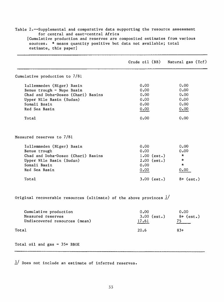
Table 2. Supplemental and comparative data supporting the resource assessmentfor central and east-central Africa
[Cumulative production and reserves are composited estimates from various sources. * means quantity positive but data not available; total estimate, this paper]
Crude oil (BB) Natural gas (Tcf)
Cumulative production to 7/81
lullemmeden (Niger) BasinBenue trough - Nupe BasinChad and Doba-Doseo (Chari) BasinsUpper Nile Basin (Sudan)Somali BasinRed Sea Basin
Total 0.00
0.000.000.000.000.000.00
0.00
Measured reserves to 7/81
lullemmeden (Niger) BasinBenue troughChad and Doba-Doseo (Chari) BasinsUpper Nile Basin (Sudan)Somali BasinRed Sea Basin
Total
0.000.001.00 (est.)2.00 (est.)0.000.00
3.00 (est.)
0.000.00***
0.00
8+ (est.)
Original recoverable resources (ultimate) of the above provinces _L'
Cumulative production Measured reserves Undiscovered resources (mean)
Total
0.003.00 (est.) 17.61
20.6
0.008+ (est.)
75_____
83+
Total oil and gas = 35+ BBOE
±J Does not include an estimate of inferred reserves.
33
in carbonate reefal beds of late Tertiary age. Pre-Tertiary fractured Nubian and older sandstone or quartzite beds of pre-rift age on buried and tilted fault blocks are also of interest.
Source rocks
Wells drilled on both sides of the Red Sea have encountered oil and gas shows, and several oil seeps are reported along both the east and west shorelines (Ahmed, 1972). Geochemical data on source-rocks are not available. Neogene marine and nearshore marine shales interbedded with sandstone and carbonate reservoirs and Miocene Globigerina shale and marl beds are potential source rocks, particularly in the northern part of the Red Sea.
Seals
Adequate regional and local seals are the Miocene salt and other evaporite facies, which intertongue westward with nearshore clastic and carbonate facies Shales interbedded with Tertiary clastic facies also are potential seals.
Traps
Fault traps, anticlinal traps associated with faults, salt swells, and draping over faulted and fractured basement blocks are common in the Red Sea Basin. Stratigraphic traps associated with sandstone pinchouts, carbonate reefoid bodies, and pinchouts against salt diapirs also are of interest. The Red Sea Basin appears to contain adequate reservoir and seal rocks but is a high-risk gas-prone exploration province because of problems in seismic mapping under the salt, unusually high temperature gradients, and questionable source-rock quality.
Estimated Resources
USGS estimates of undiscovered petroleum resources in the western Red Sea shelf region are approximately 0.2 BBO and 13.4 Tcf gas (figs. 17 and 18; tables 1 and 2).
Central Africa Interior Basins
(Upper Nile, Chad, Doba-Doseo (Chari), and lullemmeden (Niger) Basins)
The Central Africa interior basins contain a sedimentary section 1,000 to more than 6,000 m (3,300 to more than 20,000 ft) in thickness, primarily of continental and lacustrine elastics of Cretaceous and Tertiary age (figs. 3, 4, 9, and 10). The presence of intertonguing marine rocks is documented only in the latest Cretaceous-Paleocene beds of the lullemmeden and southwestern Chad Basins (Fetters, 1979a, b, 1981). The Upper Nile Basin (Sudan trough)
34
o
Z?a £ >
o L.Jor91?2- fM_
(^ dO
£~
PR03RBILIQ.OOO O.OS2 0.
\
\
\
\
V--^_
E5TI MERN MED1RN 95X 75X 50X 25X
5X. MODE S.D.
MFITES 0.20 0.00 0.00 0.00 0.00 0.31 0.82 0.20 0.32
0.0 0.3 0.6 0.9 1.2 1.5 1.8 2.1
BILLION BRRRELS RECOVERRBLE OIL2.1 2.7 3.0
Figure 17. Unconditional estimates of undiscovered recoverable oil in the Red Sea Basin. (Assessment date December 7, 1982.)
o
Zor con K*-cTUJor0 ^x: wiu_° o>- oo h- «. o _J
m or o" QQ ~-0 oa:" s:
CD_
^N\
\\
\
\
^-^-
ESTI MERN MEDIRN - 95X 75X 50X. 25X.
5X MODE S.D.
MRTES 13.40 12.35 0.00 7.53
12.35 18.13 28.90 10.50 8.50
0.0 6.0 12.0 18.0 2-J.O 30.0 36.0 -12.0 18.0
TRILLION CUBIC TEET RECOVERRBLE GRS.D 60.0
Figure 18. Unconditional estimates of undiscovered recoverable total gas in the Red Sea Basin. (Assessment date December 7, 1982.)
35
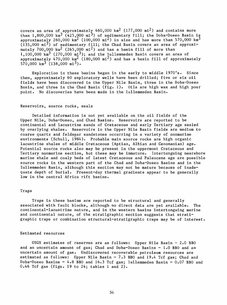
covers an area of approximately 460,000 km2 (177,000 mi2 ) and contains more than 1,800,000 km3 (425,000 mi^) of sedimentary fill; the Doba-Doseo Basin is approximately 260,000 km2 (100,000 mi2 ) in size and has more than 570,000 km3 (135,000 mi3 ) of sedimentary fill; the Chad Basin covers an area of approxi mately 700,000 km2 (265,000 mi2 ) and has a basin fill of more than 1,100,000 km3 (270,000 mi3 ); and the lullemmeden Basin covers an area of approximately 470,000 km2 (180,000 mi2 ) and has a basin fill of approximately 570,000 km3 (138,000 mi3 ).
Exploration in these basins began in the early to middle 1970 f s. Since then, approximately 60 exploratory wells have been drilled; five or six oil fields have been discovered in the Upper Nile Basin, three in the Doba-Doseo Basin, and three in the Chad Basin (fig. 1). Oils are high wax and high pour point. No discoveries have been made in the lullemmeden Basin.
Reservoirs, source rocks, seals
Detailed information is not yet available on the oil fields of the Upper Nile, Doba-Doseo, and Chad Basins. Reservoirs are reported to be continental and lacustrine sands of Cretaceous and early Tertiary age sealed by overlying shales. Reservoirs in the Upper Nile Basin fields are medium to coarse quartz and feldspar sandstones occurring in a variety of nonmarine environments (Schull, 1984). Probable main source rocks are high organic lacustrine shales of middle Cretaceous (Aptian, Albian and Cenomanian) age. Potential source rocks also may be present in the uppermost Cretaceous and Tertiary nonmarine section, but these may be immature. Intertonguing nearshore marine shale and coaly beds of latest Cretaceous and Paleocene age are possible source rocks in the western part of the Chad and Doba-Doseo Basins and in the lullemmeden Basin, although this section may not be mature because of inade quate depth of burial. Present-day thermal gradients appear to be generally low in the central Africa rift basins.
Traps
Traps in these basins are reported to be structural and generally associated with fault blocks, although no direct data are yet available. The continental-lacustrine nature, and in the western basins intertonguing marine and continental nature, of the stratigraphic section suggests that strati- graphic traps or combination structural-stratigraphic traps may be of interest
Estimated resources
USGS estimates of reserves are as follows: Upper Nile Basin - 2.0 BBO and an uncertain amount of gas; Chad and Doba-Doseo Basins - 1.0 BBO and an uncertain amount of gas. Undiscovered recoverable petroleum resources are estimated as follows: Upper Nile Basin - 7.3 BBO and 19.4 Tcf gas; Chad and Doba-Doseo Basins - 4.8 BBO and 16.3 Tcf gas; lullemmeden Basin - 0.07 BBO and 0.46 Tcf gas (figs. 19 to 24; tables 1 and 2).
36
z£.1 ci-
lOor g»
0 LL. 0
£ "
, _ , o
_J
OQ CC r\i CD -0°orCL.
o .0
"^\
N\
\^^-^
~
E5TI MERN MEDIRN - ^57. 757. 5V/. 257.
57. MODE - S.D.
MRTES 7.27 6.92 1.62 1.55 6.92 9. 61
14.10 6.25 3.83
0.0 2.5 5.0 7.5 10.0 12.5 15.0 17.5
BILLION BRRRELS RECDVERRBLE OIL20.0 22.5 25.0
Figure 19. Unconditional estimates of undiscovered recoverable oil in the Upper Nile Basin (Sudan trough). (Assessment date December 7, 1982.)
|Lt o-
LJ OCg'»
o U. O
£-
PROSRBILI0.0 0.2 01 ... i ...
^
^\
\\l
x^^__
EST1 MERN MED1RN - ^57. 75Y. 5V/. 2S7.
57. MODE S.D.
MRTES 19.37 18.02 4.96
11.95 18.02
- 25.30 38.40 15.45 10.39
0.0 7.0 H.O 21.0 20.0 35.0 12.0 19.0 56.0
TRILLION CUBIC TEET RECOVERRBLE GR563.0 70.0
Figure 20. Unconditional estimates of undiscovered recoverable total gas in the Upper Nile Basin (Sudan trough). (Assessment date December 7, 1982.)
37
z§=« 1 o"
LJa:
PROBFI3ILITY OF0.0 0;2 0.4 0
^
).0 1
\
\\
\^^__
ESTI MEflN MEDIflN 95X 75X 50X 25X
5X MODE - S.D.
.0 3.6 5M 7.2 9.0 10.0 12.6 \i.i
.BILLION BflRREL.S RECOVERflBLE OIL
MflTES 4-. 04 4-. 40 1.16 2.86 4.40 6.34-
10.00 3.60 2.78
16.2 ie .0
Figure 21. Unconditional estimates of undiscovered recoverable oil in theChad and Doba-Doseo (Chari) Basins. (Assessment date December 7, 1982.)
1-f-« 0"
UJa: i«'
PROBflBILITY OF 0.0 0.2 0.4 0 i , . . i , , . i . . ,
^Y\
\
\
\V^^__
ESTI MEflN MEDIflN - 95X 75X 50X 25X 5X
MODE S.D.
MflTES 16.26 15.06 4.50 10.11 15.06
- 21.08 32. 10
12.80 8.61
0.0 6.0 12.0 10.0 2-1.0 30.0 36.0 42.0 -18.0
TRILLION CUBIC FEET RECOVERflQLE GflS5-1.0 60.0
Figure 22. Unconditional estimates of undiscovered recoverable total gas in the Chad and Doba-Doseo (Chari) Basins. (Assessment date December 7, 1982.)
38
o
Zor « ilSi .-
oUJ
/ ) U>°
u_ °0
>~£f- 0.5°CO ^a: 2CO o_g dQ_g.
a o
\\\\v--^
ESTI MEflN MEDIflN 95X 75X 50X 25X
5X MODE S.D.
MflTES 0.07 0.00 0.00 0.00 0.00 0.00 0.46 0. 15 0. 19
0.00 0.25 0.50 0.75 1.00 1.25 1.50 1.75
BILLION BflRRELS RECOVERflBLE OIL2.00 2.25 2.50
Figure 23. Unconditional estimates of undiscovered recoverable oil in the lullemmeden (Niger) Basin. (Assessment date December 7, 1982.)
0
1$o
IlJ or§:.V ° O
z%u°SP°>(n » g dQ_ Q
O_
\
\
\
>\
"--- __ __
. - _
ESTI MEflN MEDIRN 95X 75X 50X 25X
5X MODE S.D.
MflTES 0.4-6 0.00 0.00 0.00 0.00 0.00 2.77 1.09 1.05
0.0 1.0 2.0 3.0 1.0 5.0 6.0 7.0 0.0
TRILLION CUBIC FEET RECOVERABLE GflS9.0 10.0
Figure 24. Unconditional estimates of undiscovered recoverable total gasin the lullemmeden (Niger) Basin. (Assessment date December 7. 1982.)
39
Benue Trough
Between the Zambuk ridge on the northeast border and the Niger Delta on the southwest, the Benue trough covers an area of approximately 157,000 km^ (60,000 mi2) and contains approximately 500,000 km3 (120,000 mi3 ) of sedi mentary fill. Several exploratory wells have been drilled in the southwest part of the region adjacent to the Niger Delta province without success to date. Much of the stratigraphic section is potentially of interest for petroleum exploration, but the complicated structural and thermal history of the trough are major factors affecting its petroleum potential.
Reservoirs
Thick marine and continental sandstones of middle and Late Cretaceous age are of reservoir quality in much of the trough region. However, these beds are exposed in several parts of the area because of Tertiary uplift and erosion, and adequate trapping may be a problem.
Source Rocks
Shales of source-rock quality are present in the Cretaceous and lower Tertiary section, with as much as 7 percent organic content in the Cross River Group of Cenomanian-Santonian age (figs. 3 and 11) (Fetters and Ekweozor, 1982). However, much of the younger stratigraphic section may be immature, whereas much of the total section is likely to be overmature because of the high temperature gradient in the trough in places. Coaly beds in the uppermost Cretaceous and lower Tertiary section offer some promise for biogenic gas accumulations. Basaltic intrusives and lead-zinc mineralization in several parts of the trough have adversely affected the maturation aspects of source rocks in these areas.
Seals
Cretaceous and lower Tertiary shales provide potentially adequate regional seals, although post-Cretaceous folding, faulting, and erosion have exposed these beds in many parts of the trough.
Traps
Anticlinal and fault structures are common. However, in much of the interior part of the trough, these are associated with basaltic intrusions and lead-zinc mineralization (Turner, 1981b) and undoubtedly unusually high thermal gradients.
Estimated resources
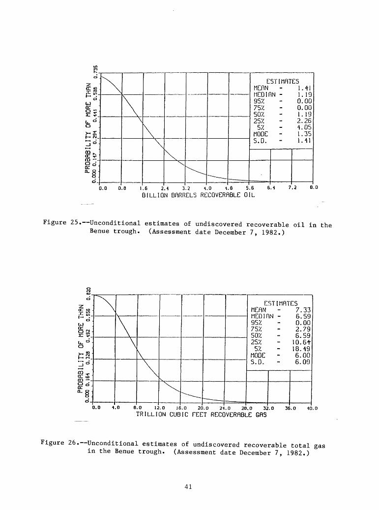
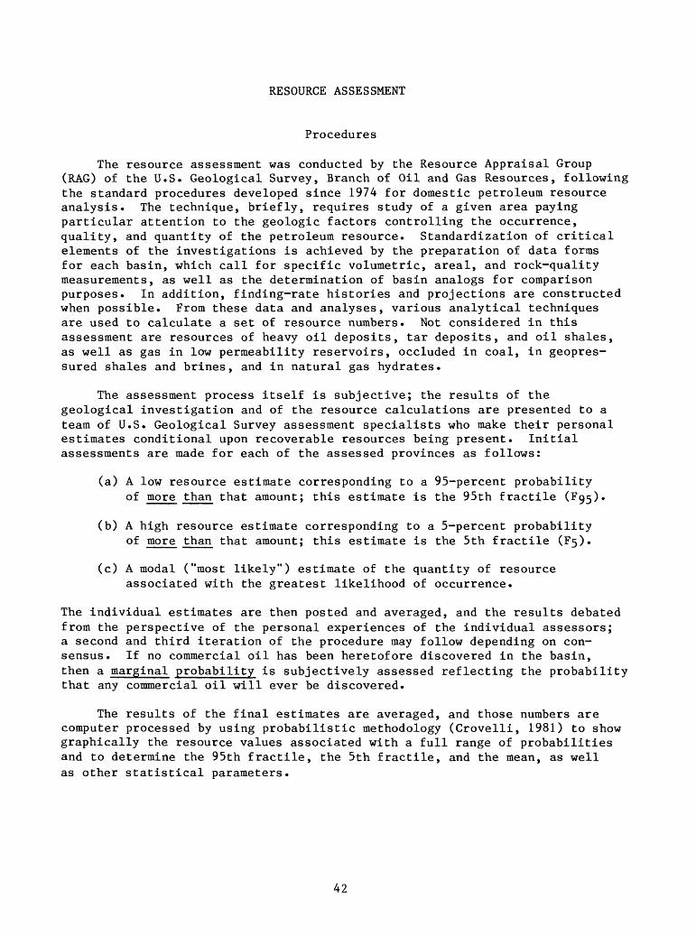
USGS estimates of undiscovered petroleum resources are 1.4 BBO and 7.3 Tcf gas (figs. 25 and 26; tables 1 and 2).
40
0
2or «-r- tot~>
0UJa:P5"u_ °0 .>- o» 1 M-n°
£*ra -8°fL. Q
0_
^1\\
\\\
\^ -^__
ESTI MEflN HEDinN - 957. 757. 507. 25X
5X MODE - 5.0.
MflTES 1.41 1. 19 0.00 0.00 1.19 2.26 4.05 1.35 1.41
0.0 0.0 1.6 2.4 3.2 1.0 4.0 5.6BILLION BfiRRELS RECOVERABLE OIL
7.2 0.0
Figure 25. Unconditional estimates of undiscovered recoverable oil in the Benue trough. (Assessment date December 7, 1982.)
o
Z
O
kJ
Cx_O
^ d
CD . a: 503 .O o*a:
"\
\\\
IN.
^~-
ESTI MEflN MEDIflN 95X 757. 507. 25X
57. MODE S.D.
MflTES 7.33 6.59 0.00 2.79 6.59
10. 6t 18.49 6.00 6.09
0.0 4,0 6.0 12.0 16.0 20.0 24.0 20.0 32.0
TRILLION CUBIC FEET RECOVERflBLE GflS36.0 40.0
Figure 26. Unconditional estimates of undiscovered recoverable total gas in the Benue trough. (Assessment date December 7, 1982.)
41
RESOURCE ASSESSMENT
Procedures
The resource assessment was conducted by the Resource Appraisal Group (RAG) of the U.S. Geological Survey, Branch of Oil and Gas Resources, following the standard procedures developed since 1974 for domestic petroleum resource analysis. The technique, briefly, requires study of a given area paying particular attention to the geologic factors controlling the occurrence, quality, and quantity of the petroleum resource. Standardization of critical elements of the investigations is achieved by the preparation of data forms for each basin, which call for specific volumetric, areal, and rock-quality measurements, as well as the determination of basin analogs for comparison purposes. In addition, finding-rate histories and projections are constructed when possible. From these data and analyses, various analytical techniques are used to calculate a set of resource numbers. Not considered in this assessment are resources of heavy oil deposits, tar deposits, and oil shales, as well as gas in low permeability reservoirs, occluded in coal, in geopres- sured shales and brines , and in natural gas hydrates .
The assessment process itself is subjective; the results of the geological investigation and of the resource calculations are presented to a team of U.S. Geological Survey assessment specialists who make their personal estimates conditional upon recoverable resources being present. Initial assessments are made for each of the assessed provinces as follows:
(a) A low resource estimate corresponding to a 95-percent probability of more than that amount; this estimate is the 95th fractile
(b) A high resource estimate corresponding to a 5-percent probability of more than that amount; this estimate is the 5th fractile (F5).
(c) A modal ("most likely") estimate of the quantity of resource associated with the greatest likelihood of occurrence.
The individual estimates are then posted and averaged, and the results debated from the perspective of the personal experiences of the individual assessors; a second and third iteration of the procedure may follow depending on con sensus. If no commercial oil has been heretofore discovered in the basin, then a marginal probability is subjectively assessed reflecting the probability that any commercial oil will ever be discovered.
The results of the final estimates are averaged, and those numbers are computer processed by using probabilistic methodology (Crovelli, 1981) to show graphically the resource values associated with a full range of probabilities and to determine the 95th fractile, the 5th fractile, and the mean, as well as other statistical parameters.
42
Assessment
The locations of the central and east-central Africa basins are shown on figures 1 and 2. Unconditional estimates by the U.S. Geological Survey of oil and gas resources in these basins are given in table 1 and figures 15 to 26. Data and summary information supporting these estimates are supplied in table 1. Assessments include data and calculations for offshore areas to 1,000 m (3,300 ft) water depths, where applicable.
Comments
I. Somali Basin
Basin appears to be gas prone with probable lack of good oil source rocks.
Many of the good onshore structures have been tested. Fault troughs in south part of area contain a very thick section of
Mesozoic and Tertiary beds that may be prospective for gas. Jurassic and Cretaceous carbonate mounds or reefs and unconformities
offer possibilities for stratigraphic traps, although freshwater flushing may be a problem.
Offshore area is relatively untested, but size of area with less than 1,000-m water depth is limited.
II. Ethiopian plateau and rift belt
Province is of high exploration risk. Potential is low because ofsevere rifting, volcanic activity, thermal history, and thin sedimentary section.
III. Red Sea Basin
Basin is gas prone. Thermal gradient is very high. Structure is very complex because of faulting, salt movement, and
difficulty in seismic interpretation beneath the salt.
IV. Upper Nile Basin (Sudan trough)
Explored section is continental and lacustrine Cretaceous and Tertiary clastic beds. Pre-Cretaceous beds are probably metamorphosed. Source rocks are Cretaceous lacustrine beds. Thermal gradient is probably moderate to low.
Oils are high wax, high pour point.
V,VI. Doba-Doseo (Chair) and Chad Basins
Existing fields may not be commercial at present because of lack of ready market and refining facilities.
Oils are high wax, high pour point.
43
Explored section is continental and lacustrine Cretaceous and Tertiary clastic beds with Cretaceous source rocks. Pre-Cretaceous beds are probably metamorphosed. Thermal gradient is probably moderate to low.
VII. lullemmeden (Niger) Basin
Most of the basin contains less than 2,000 m of explorable sedimentary section, which is primarily continental and lacustrine Cretaceous beds.
VIII. Benue trough
Sedimentary section, much of which is exposed at the surface, consists primarily of marine and continental Cretaceous clastic beds.
Temperature gradient is probably high in all of the Benue trough, with hot springs and geothermal deposits in eastern part of trough.
44
SELECTED REFERENCES
Adeleye, D. R., 1972, Nigerian Late Cretaceous stratigraphy and paleogeography:American Association of Petroleum Geologists Bulletin, v. 59, p. 2302-2313.
Agagu, 0. K., and Ekweozor, C. M., 1980, Petroleum geology of Senoniansediments in Anambra syncline southeast Nigeria (abs.): AmericanAssociation of Petroleum Geologists Bulletin, v. 64, p. 668.
Ahmed, S. S., 1972, Geology and petroleum prospects in eastern Red Sea:American Association of Petroleum Geologists Bulletin, v. 56, p. 707-719.
Anhaeusser, C. R., Mason, R., Viljoen, M. J., and Viljoen, R. P., 1969, Areappraisal of some aspects of Precambrian shelf geology: GeologicalSociety of America Bulletin, v. 80, p. 2175-2200.
Baker, B. H., and Miller, J. H., 1963, Geology and geochronology of theSeychelles Islands and structure of the floor of the Arabian Sea: Nature,v. 199, p. 346-348.
Barnes, S. U., 1976, Geology and oil prospects of Somalia, east Africa:American Association of Petroleum Geologists Bulletin, v. 60, p. 389-413.
Beltrandi, M. D., and Pyre, A., 1973, Geological evolution of southwestSomalia, in Sedimentary basins of the African coasts, part 2:Association of African Geological Surveys, p. 159-178.
Beyth, M., 1973, The Paleozoic-Mesozoic sedimentary basin of the MekeleOutlier, north Ethiopia, in Blant, B., ed., Sedimentary basins of theAfrican coasts: Association of African Geological Surveys, p. 179-190.
Blandford, W. T., 1870, Observations on the geology and zoology of Abyssinia,made during the progress of the British expedition of that country in1867-68: Macmillan and Co., London, 487 p.
Blant, G., 1973, Structure et paleogeographie du littoral meridional etoriental de 1'Afrique (Structure and paleogeography of the southeasternAfrican coast), in Sedimentary basins of the African coasts, part 2:Association of African Geological Surveys, p. 192-231.
Burke, K., Dessauvagie, T. F. J., and Whiteman, A. J., 1972, Geological historyof the Benue Valley and adjacent areas, ^.n_ Dessauvagie, T. F.J., andWhiteman, A. J., eds., African Geology: Ibadan, Nigeria, University ofIbadan, p. 187-205.
Cahen, L., and Snelling, L. J., 1966, The geochronology of equatorial Africa:Amsterdam, North Holland Publishing Co., 195 p.
Choubert, G., and Faure-Muret, A., 1971a, Chaines plissees du Precambriensuperior (Folded ranges of the upper Precambrian), In Tectonics of Africa:UNESCO, Paris, p. 295-349.
________ 197Ib, Conclusions sur le rajeunessement du craton de 1'Afriqueoccidentale (Conclusions on the restoration of the west African craton),In Tectonics of Africa: UNESCO, Paris, p. 261-264.
Crovelli, R. A., 1981, Probabilistic methodology for oil and gas resourceappraisal: U.S. Geological Survey Open-File Report 81-1151, 77 p.
Dingle, R. V., 1978, South Africa, in Moullade, M., and Nairn, A. E. M., eds.,The Phanerozoic geology of the world, the Mesozoic, A: Amsterdam,Elsevier, p. 401-434.
El-Raba'a, S. M., 1978, Structural and metamorphic evolution of the basementcomplex of Sudan: Precambrian Research, v. 6, p. A-17.
Engel, A. E. J., Dixon, T. H., and Stern, R. J., 1980, Late Precambrianevolution of Afro-Arabian crust from ocean arc to craton: GeologicalSociety of America Bulletin, v. 91, p. 699-706.
45
Franks, S., and Nairn, A. E. M., 1973, The equatorial marginal basins of WestAfrica, ^.n. Nairn, A. E. M., and Stehli, F. G., eds., The ocean basins andmargins: New York, Plenum Press, p. 301-350.
Furon, R., 1963, Geology of Africa: London, Oliver and Boyd, 377 p. Haughton, S. H., 1963, The stratigraphic history of Africa south of the Sahara:
London, Oliver and Boyd, 365 p. Holmes, A., 1965, Principles of physical geology: New York, Ronald Press,
1288 p. Hutchinson, R. W., and Engels, G. G., 1972, Tectonic evolution in the southern
Red Sea and its possible significance to older rifted continental margins:Geological Society of America Bulletin, v. 83, p. 2989-3002.
Kamen-Kaye, M., 1972, Permian Tethys and Indian Ocean: American Associationof Petroleum Geologists Bulletin, v. 56, p. 1984-1999.
________ 1978, Permian to Tertiary faunas and paleogeography: Somalia,Kenya, Tanzania, Mozambique, Madagascar, South Africa: Journal ofPetroleum Geology, v. 1, p. 79-101.
________ 1982, Mozambique-Madagascar geosyncline, 1. Deposition andarchitecture: Journal of Petroleum Geology, v. 5, p. 3-30.
Kamen-Kaye, M., and Barnes, S. U., 1979, Exploration geology of northeasternAfrica-Seychelles basin: Journal of Petroleum Geology, v. 2, p. 23-45.
Kent, P. E., 1965, An evaporite basin in southern Tanzania, in Salt basinsaround Africa: Institute of Petroleum, London, p. 41-74.
________ 1972, Mesozoic history of the east coast of Africa: Nature, v. 238,p. 147-148.
Klemme, H. D., 1980, Petroleum basins classification and characteristics:Journal of Petroleum Geology, v. 3, p. 187-207.
Kroner, A., 1977, The Precambrian geotectonic evolution of Africa: Plateaccretion versus plate destruction: Precambrian Research, v. 4, p. 163-213.
Kursten, M. 0. C., 1975, Stratigraphic units of northern Afar, in_ Pilger, A.,and Rosier, A., eds., Afar between continental and oceanic rifting, Inter- Union Commission on Geodynamics, Scientific Report No. 16, v. II:E. Schweizerbart'sche Verlagsbuchhandlung, Stuttgart, p. 168-170.
Laughton, A. S., 1966, The Gulf of Aden: Royal Society of London PhilosophicalTransactions, Series A, v. 259, p. 150-171.
Laughton, A. S., Whitmarsk, R. B., and Jones, M. T., 1970, The evolution ofthe Gulf of Aden: Royal Society of London Philosophical Transactions,v. 267A, p. 227-265.
Lowell, J. D., and Genik, G. J., 1972, Sea-floor spreading and structuralevolution of southern Red Sea: American Association of Petroleum GeologistsBulletin, v. 56, p. 247-259.
McConnell, R. B., 1972, Geological development of the rift system of easternAfrica: Geological Society of America Bulletin, v. 83, p. 2549-2572.
McKenzie, D. P., Davies, D., and Molnar, P., 1970, Plate tectonics of the RedSea and east Africa: Nature, v. 226, p. 243-248.
Mohr, P. A., 1971, Outline tectonics of Ethiopia, in_ Tectonics of Africa:UNESCO, Paris, p. 447-458.
Nairn, A. E. M., 1978, Northern and eastern Africa, ±n_ Moullade, M., and Nairn,A. E. M., eds., The Phanerozoic geology of the world, the Mesozoic, A:Amsterdam, Elsevier, p. 329-370.
Nwachukwu, S. 0., 1972, The tectonic evolution of the southern part of theBenue trough, Nigeria: Geological Magazine, v. 109, p. 411-419.
46
Olade, M. A., 1975, Evolution of Nigeria's Benue trough (aulacogen): GeologicalMagazine, v. 112, p. 575-583.
Pallister, J. W., 1971, The tectonics of east Africa, ^n_ Tectonics of Africa:UNESCO, Paris, p. 511-542.
Fetters, S. W., 1978a, Stratigraphic evolution of the Benue trough and itsimplications for the Upper Cretaceous paleogeography of west Africa:Journal of Geology, v. 86, p. 311-322.
________ 1978b, Mid-Cretaceous paleoenvironments and biostratigraphy of theBenue trough, Nigeria: Geological Society of America Bulletin, v. 89,p. 151-154.
________ 1979a, Stratigraphic history of the south-central Sahara region:Geological Society of America Bulletin, v. 90, p. 753-760. ____ 1979b, West African cratonic Stratigraphic sequences: Geology,v. 7, p. 528-531. ____ 1981, Stratigraphy of Chad and lullemmeden basins (West Africa):Eclogae Geol. Helv., v. 74, p. 139-159.
Fetters, S. W., and Ekweozor, C. M., 1982, Petroleum geology of Benue troughand southeastern Chad basin, Nigeria: American Association of PetroleumGeologists Bulletin, v. 66, p. 1141-1149.
Pilger, A., and Rosier, A., 1976, Temporal relationships in the tectonicevolution of the Afar Depression (Ethiopia) and the adjacent Afro-Arabianrift system, jji Pilger, A., and Rosier, A., eds., Afar between continentaland oceanic rifting, Proceedings of International Symposium on the Afarregion and related problems, v. 2: E. Schweizerbart'sche Verlagsbuchhand-lung, Stuttgart, p. 1-25.
Saint-Marc, P., 1978, Arabian peninsula, in The Phanerozoic geology of theworld, the Mesozoic, A: Amsterdam, Elsevier, p. 435-462.
Schull, T. J., 1984, Oil exploration in nonmarine rift basins of interior Sudan(abs.): American Association of Petroleum Geologists Bulletin, v. 68,p. 526.
Setlow, L. W., 1982, Geologic assessment of the fossil energy and geothermalpotential of the Sudan: U.S. Geological Survey, Project Report SudanInvestigation (IR) Su-2, 56 p.
Taieb, M., 1975, Evolution of Plio/Pleistocene sedimentary basin of the centralAfar (Awash Valley, Ethiopia), in. Pilger, A., and Rosier, A., eds., Afarbetween continental and oceanic rifting, Inter-Union Commission onGeodynamics, Scientific Report No. 16, v. II: Schweizerbart'scheVerlagsbuchhandlung, Stuttgart, p. 80-87.
Tanner, P. W. G., 1973, Orogenic cycles in East Africa: Geological Societyof America Bulletin, v. 84, p. 2839-2850.
Turner, D. C., 1971a, Nigeria, .in Tectonics of Africa: UNESCO, Paris, p. 255-260.
________ 197lb, The sedimentary cover in Nigeria, in Tectonics of Africa:UNESCO, Paris, p. 403-405.
UNESCO, 1971, Tectonique de 1'Afrique (Tectonics of Africa): UNESCO, Paris602 p.
Vail, J. R., 1978, Outline of the geology and mineral deposits of theDemocratic Republic of the Sudan and adjacent areas: Institute ofGeological Sciences, Overseas Geology and Mineral Resources, no. 49,London, 68 p.
47
Walters, R., and Linton, R. E., 1973, The sedimentary basins of coastal Kenya,in Sedimentary basins of the African coasts, part 2: Association ofAfrican Geological Surveys, p. 133-158.
Weber, K. J., and Daukoru, E., 1975, Petroleum geology of the Niger Delta:World Petroleum Congress, 9th, Proceedings, v. 2, Geology, p. 209-222.
Whiteman, A. J., 1971a, The geology of the Sudan Republic: Oxford, ClarendonPress, 289 p.
________ 1971b, Structural geology of Sudan, in Tectonics of Africa: UNESCO,Paris, p. 433-444.
________ 1981, East Africa basins: reserves, resources and prospects, inPetroleum exploration strategies in developing countries: United Nations meeting, Hague, Proceedings, United Nations Natural Resources and Energy Division, p. 51-98.
48