Embed Size (px)
Citation preview
Abh. Geol. B.-A. 26e C. G. I.
34 p. 197—255 52 figures Wien 1. 5. 1980
International Geological Congress
26 th Session
Excursion 035 A
Geology and Tectonics of the Eastern Alps
(Middle Sector)
by
ALEXANDER TOLLMANN
With contributions from A. FENNINGER, W. FRANK, B. PLÖCHINGER, S. PREY, J.-M. SCHRAMM & G. TICHY
Author's address: Geologisches Institut, Universität, Universitätsstraße 7, A-1010 Wien, Austria.
©Geol. Bundesanstalt, Wien; download unter www.geologie.ac.at
Contents
Summary 198 A) General introduction (A. TOLLMANN) . . . . 198
1. Literature 198 2. The geological position of the region visited
within the European framework . . . . 198 3. The geological peculiarity of the Eastern Alps . 200 4. The main structure of the Eastern Alps in the
section visited 200 5. Paleogeography and orogenic cycles . . . 202 6. Characteristics of the main units of the Eastern
Alps in the region visited 204 7. Remarks to the mineral deposits in the scope
of the excursion 209
B) Excursion description 210 1st day: Ultrahelvetikum and Flysch in Upper
Austria near Gmunden (S. PREY) . . 210 2nd day: The Hallstatt Zone and its framework
near Hallstatt (A. TOLLMANN) . . . 214 3rd day: Tectonics and facies of the Hallstatt
Zone in the eastern Salzkammergut (A. TOLLMANN) 219
4th day: The Lower Austroalpine of the central Radstadt Tauern (A. TOLLMANN) . . 222
5th day: Lower Austroalpine unit in the southern part of the Radstadt Tauern (A. TOLL-MANN) 229
6th day: Middle Austroalpine and Gurktal nappe east of the Tauern Window (A. TOLL-MANN) 233
7th day: The late Paleozoic of the Nassfeld Area in the Carnic Alps (A. FENNINGER) . . 238
8th day: The Penninic System along the Groß-glockner road (W. FRANK) . . . . 241
We can restrict the general in t roduct ion to this excursion, because you wil l receive a short "Einführung in die Geologie Österreichs" on the occasion of this congress. Therefore you wil l f ind in the following pr i mar i ly those special instructions, concerning the middle sector of the Eastern Alps, visited by this excursion.
In the following some newer books and papers concerning this matter are mentioned: In English: E. OXBURGH: The Eastern Alps — a geological excursion guide, Proceed, geol. Assoc, 79/1, p. 47—124, Colchester 1968. — In French:
The Eastern Alps represent a sector of the nor thern branch' of the young, alpidic Medi te r ranean mounta in system. In this p a r t of the Alps the tectonic movements
9th day: The Grauwackenzone and the Northern Limestone Alps in Salzburg (B. PLÖCHIN-GER, J.-M. SCHRAMM & G. TICHY) . 246
S u m m a r y The excursion into the middle sector of the Eastern Alps
will demonstrate by selected examples along two cross-sections the stratigraphy, the different facies regions, metamorphosis, nappe structure and microtectonics. The sequence of nappes will be shown along the meridian of Salzburg and of Hallstatt. The P e n n i n i c nappe system appears as the deepest tectonic unit in the center of the Eastern Alps in the region of the window of the Hohe Tauern. It is characterised by an eugeosynclinal facies and by a high degree of metamorphosis. Above this lowermost unit follows the vast system of Austroalpine nappes ("Ostalpin"), devided into three distinct tectonic units: At the base the L o w e r A u s t r o a l p i n e nappe system, which is represented by the Radstädter Tauern; the M i d d l e A u s t r o a l p i n e system, which forms especially the large masses of Alt-kristallin in the central axial region of the Eastern Alps beyond the Tauern Window only with a thin and uncomplete mesozoic cover under specific facies; the U p p e r A u s t r o a l p i n e nappe system, which comprises firstly the Northern Limestone Alps marked by a typical Tethys facies (aristo-geosynclinal facies) rich in fossils, then the Grauwackenzone, furthermore rests of this sheet in the Central Alps like the Gurktal nappe and a remainder near the root zone, the Drauzug in the Gailtal mountains. In its southernmost point the excursion reaches the northern margin of the Carnic Alps, part of the S o u t h e r n A l p s . The northern rim of the Alps is shown in the H e l v e t i c Z o n e with its series under miogeosynclinal facies, overthrust by the F l y s c h n a p p e .
J. GEYSSANT & A. TOLLMANN: Alpes autrichiennes, C. r. Soc. geol. France, 1966/11, p . 413—472, Paris 1966. — In German: H. BÖGEL & K. SCHMIDT: Kleine Geologie der Ostalpen, 231 p., Thun (Ott-Verlag) 1976; W. D E L - N E G R O : Abriß der Geologie von Österreich, 138 p., Wien (Geol. Bundesanstalt) 1977; M. GWINNER: Geologie der Alpen, 477 p., Stuttgart (Schweizerbart) 1971; A. TOLLMANN: Monographie der Nördlichen Kalkalpen, vol. 1—3, Wien (Deuticke) 1973, 1976; Geologie von Österreich, vol. 1: Die Zentralalpen, 766 p., Wien (Deuticke) 1977.
in the alpidic era indicate a general n o r t h w a r d direction. The main structures were bui l t during U p p e r Cre ta ceous and Lower Ter t ia ry . The orogenesis diminished
A) General Introduction By A. T O L L M A N N
1. Literature
2. The geological position of the region visited by the excursion within the European framework
(Fig- 1)
198
©Geol. Bundesanstalt, Wien; download unter www.geologie.ac.at
| area visited by the excursion
| direction of movement
P R E C A M B R I A N
B A S E M E N
V A R I SC I D E 5
TAURIDE<iE
Fig. 1: The position of the Eastern Alps and the excursion route within the geological framework in Europe.
the width of the geosyncline from nearly 1000 km during the middle Mesozoic to approximate 150 km today.
The northern branch of this young Eurasiatic mountain system, built up of rests of the floor of the Mesozoic Tethys ocean, leads from the Betic Cordillera in Spain, from the Alps, Carpathians and the Balkans
in Europe to the Pontides in northern Anatolia and to the Elburs. The southern branch of this Mediterranean system, mooving generally southwards, is comprised of the Rif, the Maghrebides within the Atlas, the Apennines, Southern Alps, Dinarides, Hellenides in Europe, Taurides in the Turkey, and leads to the Himalayas.
This mountain system arised from the wide Tethys
199
©Geol. Bundesanstalt, Wien; download unter www.geologie.ac.at
ocean, which also contained the longish Kreios Plate with its continental crust, and a lot of younger micro-continents. The orogenesis was produced by the collision of the African and the Euroasiatic plates during the Cretaceous and the Tertiary. In the Eastern Alps a part of the former, older mountain system, the Variscides, are preserved with its old tectonic structures, e. g., in
the Carnic Alps and in the Altkristallin of the Middle Austroalpine system. This Variscic system is preserved in a width of about 600 km maintaining a continuity in the alpin foreland in middle Europe. In front of the Eastern Alps we find it in the form of the Bohemian Massif with internal Variscic nappe structure, with a southeastern direction of movement.
3. The geological peculiarity of the Eastern Alps
The Eastern Alps are dominated by nappe structure. Six nappe systems are piled up in this chain. Each nappe system in itself consists of individual nappes. The width of the main nappe transport vary from some ten kilometers up to 165 km (Upper Austroalpine nappe system). Already during the stage of geosyncline in the Mesozoic these units had individual facies. There are also differences in the distribution of the non-meta-morphic Paleozoic in the different nappe systems. Most of the nappes also contain crystalline rocks as remainders of a continental crust; only in the southern part of the Penninic nappe system are hints of a direct sedimentation of Mesozoic on oceanic crust.
The considerable shortening of the crust in the Eastern Alps during the alpidic orogenesis produced a crustal thickness of 50 km in comparison with 33 km thickness of the crust of the Central European foreland. Only in its eastern part the crust beneath the Alps thins to 27 km, as below the Pannonic Basin in Hungary. This attenuation is a young effect in connection with the exaggeration of the Carpathians bend according to the principle of back arc basin forming.
The piling of the alpine nappes took place in various phases. Shortening of the crust and subduction began already in the younger part of the Lower Cretaceous: Austroalpine phase of the Barreme-Aptian, Austrian phase of the Upper Albian-Cenomanian. During this time the main central nappe systems began their migration. The main nappe building in the Upper Austroalpine system may be fixed by the Gosau formation, superposing in disconformity the limits of the nappes in the Northern Limestone Alps. Therefore the thrusting of the nappes in this part of the Eastern Alps
can be dated as pregosauic, that is equal to the Mediterranean phase in the upper Turonian 90 million years ago. This data is in accordance with the radiometric age of the metamorphosis in the Austroalpine system ("Schneeberg crystallisation"). In this time the Penninic system of the Hohe Tauern was subducted beneath the Austroalpine units. The younger main phase of transport of the nappe systems is the Illyric-Pyreneen phase at the end of the Eocene. During this time the central units of the Eastern Alps were transported above the marginal units. In this way vast parts of these marginal zones (Flysch Zone, Helvetic Zone) were covered and the sedimentation was finished in this region. A new foredeep formed. The Alps entered their Molasse stage: Beginning with the Upper Eocene the debris from the Alps and the foreland accumulated in the Molasse Zone.
The younger phase of metamorphosis in the Eastern Alps, dated in the Penninic system, occured in the Lower Tertiary and is perhaps in connection with the second main thrust mentioned above at the end of the Eocene. In the lower part of the Penninic system in the Hohe Tauern the metamorphosis then just attains the amphibolite facies.
After the reduction of the tangential pressure within the upper Tertiary the orogenesis, characterized by nappe building, is replaced by vertical isostatic movements. This late phase of mountain building is called "montigenesis", leading to the morphological forming of mountains: big masses rise to considerable hights, on the other hand great basins are formed. In the Pliocene the chain of high mountains is nearly complete and will be finished in the Pleistocene by the activity of the vast glaciation.
4. The main structure of the Eastern Alps in the section visited
(Fig. 2, 3)
In the middle sector of the Eastern Alps we find the following main tectonic units, advancing from north to south, from the frontal part of the mountain chain to the lower units of the Central Alps:
a) Helvetic Zone b) Flysch Zone
marginal units
c) Upper Austroalpine nappe system: Northern Limestone Alps (Mesozoic) and Grauwackenzone (Paleozoic)
d) Middle Austroalpine nappe system: Altkristallin and Stangalm Mesozoic in centralalpine facies
e) Lower Austroalpine nappe system: Crystalline por-
200
©Geol. Bundesanstalt, Wien; download unter www.geologie.ac.at
. MÜNCHEN
_^ + • M t t t . t . t ^ m ^ M t j BUOUJEIS > * • * • * • * * • • * »
+ + + 4 - * + 4 4 + + + -»--t- + + + + + - * + + 4 + +
+ + 4 4 4 4 + 4 + -* + + 4 - + + + * + + + + + + + -
+ + ß o h t m i a n M a s s i f * + + + • + + + + + +. + + + + + + + + + + + + + +
+ 4 4 4 4 4 4 4 4 4 4 4 4 + 4 4 + + 4 + 4 4 4 *
PASSAU, • * •
JIEN ^ Ä
••SALZBURG:
BREGENZ
Kadsladterf [ I I . 'ol t , fa
i*V« 3!fliT
• * * • fey-jfe
Tf8, tnl
tep^>. KLAGE.NFURT
'GRAZ
»MARBUR6
hiddle Aostroalpine-, |Sr5d Pennine-Schieferhülle BUH L o " ? r A u s , r ° = • • Sedimentary rocks l V V | Pennine-centralgneisses a p " l e ' H I H I Crystalline
ft old crystall ine
Upper Austroalpin e : EESj Mesoxoic u t H | Pale-ozoic ^jl}f C rys ta l l i ne
P a r i a d r i a t i c s G*l. Gurktat Nappe 6P Paleozoic of Grar, K Pennine of Rechnitx
Fig. 2: Tectonic sketch of the Eastern Alps (A. TOLLMANN, 1978) with the excursion route.
tion, Paleozoic and metamorphic Mesozoic in cen-tralalpine facies in the Radstadt Tauern
f) Penninic Zone: Tauern Window with Crystalline portion, Central Gneiss, Schieferhülle with Paleozoic and Mesozoic parts.
Figures 2 and 3 show the arrangement of this nappe pile.
The P e n n i n i c s y s t e m appears as the lowermost unit in the large culmination in the center of the Eastern Alps, namely in the Tauern Window.
Flysch zone Grauwacken zone SURKTAL NAPPE
Helvetikum Northern Calcareous Alps
T r a u n s t e i n Hohe S c h r o t t D a c h s t e i n
X I Molasse zone
M. and Lower Austroalpine Upper Austroalpine Drau unit
S t a n g a l m D o b r a t s c h
x x x x x x x x x x x x x x x x x x x x x x x x x x x
D DACHSTEIN NAPPE HA HALLSTATT ZONE T TIR0L1KUM & BAJUVARIKUM
L L L. L L
25 — I —
P E N N I N I C TAUERN WINDOW
50 = 1
Fig. 3: Cross section in the middle sector of the Eastern Alps (A. TOLLMANN, 1976, fig. 9).
201
©Geol. Bundesanstalt, Wien; download unter www.geologie.ac.at
The units of the A u s t r o a l p i n e s y s t e m originate from the region south of the Tauern and were thrust on and above the Tauern Pennine towards the north. The Lower Middle Austroalpine unit rested in the Central Alps, covers the Pennine and shows specific, slight metamorphic Mesozoic series in "central-alpine" facies, poor in fossils. The Drauzug southern-ward of the Tauern Window and the Northern Limestone Alps thrust far above the Hohe Tauern, belong to the Upper Austroalpine unit. These two comprise a
Figure 4 shows the pattern of the main facies regions during the time of geosyncline prior to the orogenesis.
a) A specific zone developed in the cental part of the Tethys during the U p p e r P e r m i a n in the Northern Limestone Alps, characterized by the Haselgebirge, rich in salt, gypsum and anhydrite.
b) During T r i a s s i c time distinct differences existed between the facies zones of the Alps, generally arranged in longitudinal direction: The Helvetic zone still did not exist; the Penninic realm shows miogeosyncli-nal facies with variegated schists and sandstones in the Upper Triassic; in the Austroalpine region the Triassic contains sediments of a carbonate plattform type, whereby the thickness increases southward up to some kilometers. The northern part of this region include the "centralalpine" facies, the southern one the "nord-alpine" facies. To the latter belong the Northern Limestone Alps, which show the Hauptdolomit facies (with the Norian Hauptdolomit) in the north, and the Dachsteinkalk facies (with the Norian-Rhaetian Dachstein limestone) in the south. In the last-mentioned region the Hallstatt facies (with thin red Hallstatt limestone in the Middle and Upper Triassic) is intercalated in some narrow channels.
c) While the continental crust of the geosyncline attenuated in the Triassic by fracturation and the first vulcanites appeared, it began to burst during the J u r a s s i c time. In the northern and southern part of the Penninic realm an ocean floor built up the basement for the following sedimentation (Glockner nappe in the southern Pennine, perhaps of the Flysch Zone in the northern Pennine). As a consequence of attenuation and the opening of the continental crust, the floor of the Tethys ocean subsided in accordance with the lows of isostasy. Therefore in the Jurassic sediments like marl, clay, chert and pelagic limestone dominated, accompanied by red nodular limestones. Carbonate platform sediments like reef limestone (Plassenkalk) only reappear in the Northern Limestone Alps toward the end of the Jurassic.
In the eugeosynclinal Penninic realm of the Hohe Tauern during the Jurassic and Lower Cretaceous big
famous non-metamorphic Mesozoic series, rich in formations and fossils, e. g., the Hallstatt Limestone with the great number of ammonites. The internal nappe structure of the Limestone Alps offers eminent complications. The Palaeozoic basement of the Limestone Alps appears in the Grauwackenzone, built up of low metamorphic series of fossiliferous formations. As an important remainder in the same position as the Grauwackenzone we see the Paleozoic mass of the Gurktal nappe within the central zone of the Eastern Alps.
series of marly and detritic sediments, also with graded bedding are produced, alternating with submarine basic effusiva with pillow structure — today metamorphosi-zed to blueschists, greenschists and eclogites. Masses of breccias in the Penninic and Lower Austroalpine area demonstrate the high mobility of the crust.
d) At the end of the L o w e r C r e t a c e o u s the geosyncline was transformed to the orogen. During the M i d d l e C r e t a c e o u s the subduction started. The sedimentation in the present lowermost tectonic units in the Central Alps ended, because they were covered by thrusts of higher nappe sheets. In the uppermost tectonic unit, the Upper Austroalpine system, the sedimentation during the Cretaceous became very incomplete. It ends early in the Drauzug and in the southern part of the Limestone Alps, continuing only in the northern part of the latter. After the revolution by the nappe formation in the course of the Mediterranean pre-gosauic phase marine sediments were deposited in the Limestone Alps only in some local "Gosau" basins during Senonian and Lower Tertiary. In the Eocene the sedimentation terminates definitely in the Northern Limestone Alps.
e) The coherent sedimentation during the T e r t i a r y at first was restricted to the Flysch Zone and Helvetic Zone in the north of the Alps, joining the Cretaceous series of these units. The Helvetic realm contains the sediments of the shallow shelf of the Bohemian Massif, rich in macro- and microfossils, divided into a northern subzone, rich in limestone (corresponding to the Helvetic Zone of Switzerland) and a southern one, rich in variegated marls (named Ultrahel-vetic Zone). Adjoining to these marginal zones in the south, we find the Flysch belt, a long and deep trough, produced by the beginning subduction in the region of northern Pennine. The series of this trough are partially preserved in the Rhenodanubian Flysch Zone. Here
Fig. 4: Paleogeographic sketch of the main facies zones of the Eastern Alps during geosynclinale stage in the Triassic and
Jurassic (A. TOLLMANN, 1978, fig. 2).
5. Paleogeography and orogenic cycles
202
©Geol. Bundesanstalt, Wien; download unter www.geologie.ac.at
+• t +• +
©Geol. Bundesanstalt, Wien; download unter www.geologie.ac.at
RECENT: Deep Mountain roots
BM Bohemian Massif rIO Molasse HE He.lve.Kcum Fy Flysch Zone NP North Pennine UP Ultrapienidic Rise MP Middle Pennine 5P South Pennine LA Lower Austroalpine MA Middle Austroalpine UA Upper Austroalpine 5A Southalpine PA Penadriatic Suture
N
MIOCENE: tfolasse stage
MO HE UA _ -
LATE EOCENE: Subductionof the Nor thern zones MOL
U.CRETACEOUS'. Nappe Formation mithin the Austroalp ine HE Fy UA
M. CRETACEOUS: Begin of the Penninic Subduct ion LA
^ I H ^ .
MA UA SA
1 U.JURASSIC/L.CRETACEOUS: Oceanfloor spreading
(NP) MP SP
UTRIASSIc: Extens ion of the Crust VORLAND | NORTHERN ALPS
E / U P MP \SP / L A / ' ^ M A T ^JZU^MSZ
SOUTHE.RN A L P S
233
Fig. 5: Model of the genesis of the Eastern Alps shown by the sequence of stages from geosyncline to orogene in schematic sections (A. TOLLMANN, 1978, fig. 3).
we find a typical flysch sediment with all characteristics of this type of sediment as graded bedding, flute casts, specific ichnofacies etc. Furthermore this trough with his typical "orogenic" sediments, formed a new element in the Eastern Alps, established oblique to the older zones, running from the Northern Penninic region in the west to the Helvetic region in the east, so that the sedimentation took place on different basement.
The change from the Helvetic stage to the Molasse stage mentioned above occured within the Upper Eocene. The exogeosyncline of the Molasse received marine sediments till the Karpatian at the end of Lower Miocene.
Figure 5 shows the tectonic development of the Eastern Alps.
6. Characteristics of the main units of the Eastern Alps in the region visited by the excursion
In the following the tectonic units mentioned above will be characterized by stratigraphic range, tectonic style and degree of metamorphosis. Figure 6 gives an orientation about the stratigraphic sequences of all units, visited by the excursion — therefore, a description in the text is unnecessary.
The description below treats the units in the order of north to south, that is, from the units in higher tec
tonic positions to those in lower ones — except for the marginal units in the north.
a) The H e l v e t i c unit contains a Mesozoic series from the Liassic Gresten beds to the pelagic limestones and marls of the Cretaceous and the marly Lower Tertiary. The thickness of these series is moderate. The influence of the German foreland in litho- and biofacies is evident. The younger part of the sequence, comprising
204
©Geol. Bundesanstalt, Wien; download unter www.geologie.ac.at
Cretaceous and Tertiary, shows a distinct difference between a northern subfacies rich in limestones and a southern one rich in marls. The contrast between the abundance of pelagic foraminifera in the Cretaceous and Tertiary formations in the Helvetic realm, and the poverty of those in the neighbouring and overthrust Flysch nappe (which contains especially arenaceous foraminifera) is striking.
The Helvetic Zone is almost totally thrust by the flysch nappe. It appears only with frontal parts and by slit-like tectonic windows on the surface. It was also found in boreholes beneath the Flysch.
b) F l y s c h Z o n e : This unit is totally stripped from its basement, which was built by the older Meso-zoic beds of the northern Pennine and the southern Helvetic Zones. The series of the Flysch unit ranges from Albian to Eocene. The Upper Cretaceous part presents in the best way the particularities of flysch facies. The participation of Tertiary formations diminishes toward the west and increases toward the Carpathians in the east. The flysch sediments were deposited in the deep sea, dominating below the CCD. The paleocurrents were directed westward.
In this sector the Flysch Zone forms only one nappe, strongly folded internally. This sheet is divided into three nappes only far in the east, in the Vienna Forest. The flysch, overthrusting the Helvetic Zone, is itself overthrust by the Northern Limestone Alps. One can find flysch windows in two thirds of the Limestone Alps. The beds of flysch rest in an un-metamorphic state.
c) N o r t h e r n L i m e s t o n e A l p s (Calcareous Alps): The sequence of this unit passes from Permian up to Eocene. The morphological features are determined by thick carbonate masses of Triassic age, which form large massifs of dolomite and limestone, while the Jurassic marls and slates are insignificant for rock face formation. Figures 4 and 6 show the Triassic facies zones of the Limestone Alps. Some remarks on this complicated matter: the Hauptdolomit facies includes in this region in the Middle Triassic Ladinian Wetterstein limestone, in the Upper Triassic Hauptdolomit and the marly and calcareous, fossiliferous Rhaetic Kössen beds. The Dachsteinkalk facies, adjoining to the south, comprises vice versa the (Ramsau-)dolomite in the Middle Triassic and thick limestone (Dachstein limestone) in the Upper Triassic. The reefzone of this carbonate platform in the Upper Triassic appear in the southern region of Dachsteinkalk facies, divided into many individual reefs, while the northern part is formed by thick bedded Dachstein limestone of lagoon type. A detailed reconstruction of the original position of the channels with Hall-statt limestone in between the platform sediments is still to be made.
Now one supposes three channels with Hallstatt facies within the Dachsteinkalk area: The northern one in the region Ischl—Grundlsee is characterized by a facies rich in marls in the Upper Triassic; rests of the middle chan
nel can be seen in the Mandlingzug near Radstadt; the southern channel joins at the southern rim of the Dachstein massif — tectonical outliers of this southern channel are preserved near Mitterndorf in the Styrian Salz-kammergut. Mount Plassen near Hallstatt also seems to derive from this channel.
This middle part of the Northern Limestone Alps was divided by the orogenesis during the Mediterranean phase in Turonian time into the following nappes, piled from bottom (north) to top (south): Lunz nappe with the Langbath Mass, the Staufen-Höllengebirge nappe, the Totengebirge nappe. These three units show mainly Hauptdolomit facies (only the latter passes to the Dachsteinkalk facies), followed by the Zlambach Mass (Hall-statt facies), the Warscheneck nappe, the Mandling Mass, the important Dachstein nappe and finally isolated outliers of the southernmost Hallstatt unit, that is, the Mitterndorf nappe. The contrast in facies and thickness of the latter units is striking.
The great rock-masses of the Limestone Alps did not suffer a metamorphosis. However in the southern third of the mountain one can see an anchimetamorphic transformation. Finally, in the basal beds of the southern margin one can find low graded greenschist metamorphosis.
d) G r a u w a c k e n z o n e . It forms the strati-graphic basement of the Limestone Alps and therefore occurs along the southern margin of these mountains bordering the Altkristallin of the Central Alps. This zone comprises a sequence from the Ordovician to the Upper Carboniferous. In the Lower Palaeozoic slates dominate. Vulcanites of basic or acid character and carbonates also participate in the composition of the Grauwackenzone. Coarse detritic Upper Carboniferous is reduced in this middle part. Variscan and Alpine tectonics affected this zone. During both orogenesis the meta-morphism attained only the greenschist facies.
In the Central Alps, the excursion arrives at the western border of the G u r k t a l n a p p e , which represents a part of the Upper Austroalpine. It consists of a very thick mass of slates of Ordovician and Devonian age (Eisenhut slates), few carbonates and a thick Upper Carboniferous mass of sandstones and conglomerates. This nappe with a width of 60 km is thrust far in a northern direction, in consequence of the west-east orientation of its fold axis, combined with the underlying Stangalm Mesozoic along its western rim.
e) M i d d l e A u s t r o a l p i n e : The vast and thick Altkristallin of the Central Alps outside the Tauern Window, which is touched during the excursion in the Schladming Tauern near Radstadt, along the Lieser valley in Carinthia and between Kreuzeck and the Schober mountain NE of Lienz, does not form the normal basement of the Paleozoic mentioned above. It represents — as decided only twenty years ago — an independent tectonic unit, a typical basement nappe with only few remnants of its own Mesozoic cover in
205
©Geol. Bundesanstalt, Wien; download unter www.geologie.ac.at
ZONE MOLASSE ZDNE HELVETIKUM ULTRAHELVET. FLY5CH ZONE PENNINE ZONE LOWER AUSTRO-A. MIDDLE AUSTRO-A
.FACIES
T I M E
Germanic f a c i a s
wi th in
the b a s e m e n t
M i o g e o s y n d i n a l e f a c i e s E u g e o s y n c l i n a l a f a c i e s C e n t r a l a l p i n e f a c i e s
Flqsch f a c i e s p a r t . b e l o u i CCD
Hochsteg f a d e s (r ise)
P e n n i n i c f a c i e s
Glockner Brennkgl fac ies fac ies
Hochfeind facies
Pleisling f a c i e s
S t a n g a l m (GurktaL Alps')
NE06ENE
PALEOGENE
M.-U. MIOCENE
Fresh-water series
L.MIOCENE
- U . EOCENE
Molassc marine ti.fcöc. stockleHen M.EOC. Addhol2-,£rz-bcds L.EOC. Mi1hil-,Roterz bads PALEQC. Litholhamn.lst.
marls, sandst.
UPPER CRET. U.CAMFANIAN-l.TURON.
Marls,sandstones CENOMANlAN:t
Green sandstone
SENuNIANiGreuJvarie-gated marls
rURON:Redmnrls,lst, gum: Spotted limest. ALSIEN: Black marls
LOWER CRET.
MALM Massive limestone
and dolomite p.p.oolitic
Glauconitic sandstone
DOGGER
LIAS
RHAETIAN
N0R1AN
Keuper:
Variegated
shales and
sandstone
CARNIAN
LADINIAN
AN15IAN
5KYTH1AN
ZECH5TEIN
ROTLIEGEND
SILE5IAN WESTFALIAN:
sandstone,conglo:
merate, schists
DINANTIAN
DEVONIAN
SILURIAN
ORDOVICIAN
CAMBRIAN
EDCEME-PALEDCENE Variegated mart Numrnulitic limest.
SENONIAN-ALBIAN Variegated and spotted marls
LPALEQ6ENE--U.CAMPANIAN: Soft sandstone
Uppermost va negated shales
Zementmergel series Uppervaneq. shales Reiselsberq sandst.
U.NEQCOM.-.BIack marls L.NEDCDM.-.Aptychus
Gault quartzite U-Nepcom. Husch
Kaserer series Bünden shists
Aptychus limestones, Vulcanites
Ruhpolding chert
Waidhoten and
Neuhaus beds
Gresten beds ("Limest., marls, •rkose t coa l )
Hochsteg limestone-, dolomite
Phyilite
Hochsteg
quartzite
II n
l!
5chmarz= eck -ser ies:
breccia, quartz.
"Aptych'lst., Chert mit-h manganese
.(Aptychus" Limest.
Chert with mangan.
Türken -kogel -se r ies : s la tes , breccias
Violett Crinoid. limest.
Black calc = slates
Siliceous
calc-shales
Sandy shales
Limestone tCrinoides
U.Rhaetian limestone
Kassen beds
Calcphyllites
Platfenkalk
Hauptdolomit Hauptdolomit
Local ly
remnants
of
Permotr'iassic
sediments
(analogous
to
the other
Penninic
s e r i e s )
3 E
Marble Rauh-
Luacke
Locally remnants of analog. Permo = triassic sedim.
Camion dolomite Breccias, shales
Partnach dolomite
Dolomite, breccia, Cidans limestone * Black shales
Wetterstein
do lomi te
Tuffs LdeHerstein
dolomite
TrDchites dolomite Dot, streaky limest, Sanded limestone Rauhiuacke
Dolomite Banded
limestone Rauhiuacke
Alpine f?Dt shales Lontschfeid
qua r t z i t e
Alpine Rötshaies 5emmenng
quar tz i te
A lp ine Verrucano-.
5 e n z J t - a n d
Phengite schists
Alp ine Verrucono:
Q u a r t z i t e ,
Quartzkera« tophyre
BASEMENT Bohemian Crystall ine
Buch-monument
granite
Northpenninic and Ul t rahelvet ic socle
C e n t r a l g n e i s s III! T m e n q Crys ta l l ine .
L ieser ta l Crys ta l l ine
Fig. 6: Stratigraphical sequences of the main units of the Eastern Alps in its middle sector.
206
©Geol. Bundesanstalt, Wien; download unter www.geologie.ac.at
V UPPER AU5TR0ALPINE UNIT Ar i s t ogeosync l i na l e facias
H
N o r t h a l p i n e f a c i c s
N o r t h e r n L i m e s t o n e A l p s
Ba juvar ikum and Tirol ikum Nordtirol fac.(Hauptdql, fao)
LotüerJuvavikum Zlambachfac.
Hallstatt Facies Salzberqfac.
U.Juvav. Dachst.k.f.
Gosau f o r m a t i o n : Vpresian marls of Schorn Zwicse la lm beds (Paleocene-U. Macstricht.): marls, sst.,cDnqlomerate Nierental beds (Maes t r i ch t . -U .Campan) : red pe laq .mar l s , sands tone Qo&au r ieh in foss i l s (L .Campan . - L.Coniac.) -.marls, sst7Rudistelst.,congl-
Losenstein beds (Alb.-Tbron.) Conglorn., sandst .mar l
Tannheim beds fU.Apl.-Alb.) dark grey and red marls
Rossfeld beds(Valendis:Apt.):sst.,congl. Schramhachbeds(Berrias.-Apt)CQlcmarls
Oberalrn-,Aptychus-,&armstein-and Tressenstein limestone
Haselberg-and Agatha Limestone (red nodulose Ammonite limest.)
Ruhpolding radiolar i te (chert)
Strubberq beds (slates,cherts ujith manqane&e,breccias)
Klaus limest. (red nodulose (imest.)
Aligau ibeds (spotted marls) Hier lat i limestone (Crinaidal limest.) Adnet limestone (red nodulose
Ammonite tirne-stone)
U.Rhaetian ( ree f ) l imestone Kassen beds (dark marls and
ümestones)
P la t tenka l k
Hauptdolomit
Opponitz beds (dol.,Ist.) Lunzbeds (sands t ) Trachyceras beds (slates)
Northalpine Raibl beds
Uetterste in l imestone and dolomite.
Reifling ( imestonefnodul. chertylsl.) Steinalm l imestoneanddolomite Gutenstein l imest. (black, bedd-M.) Reichenhall rauhwacke
Werfen beds Cred and green sandq shales and sandstones)
Haselqebi rqe + gypsum .g £
Mitterberg beds ^ "g1
/ • •> = p, (green senes) c* ü
Fellersbach beds £ S •£ "S
(violett series) o £ x o.
GRAUUACKEN ZONE Ldestfalian sandstone Gainfeld conglomerate
Visean sandstone
U. DEVON.-, limest., red chert, s lates MDEVON.: black dolomite L.DEVDN.-. red moHIed limest, dolomite
U.5ILUR.: grey and black dolomites Steiqwand. Lst. ; Langeck lyd i te
M.-L.-SIL: Upper Idildschbnauphyllite
Porphyroide Lower Ui ldschonau phyl l i te lu i th
metadiabase and tu f fs
Crys fa l l i ne preserved only by pebbles
Allgäu beds (marl)
Zlambach beds
(marl , l imestone)
P&tschen limestone
Peda+a lime&t. and
dolomite
U. s lates Cidaris l imest, dol . Lum beds
Black Reifung limest
Reif l ing limestone
Steinalm limestone
Anisian dolomite
Gutenstein limestone
Ulerfen l imestone
Werfen shales
Plassen (reef) limest Oberalm-, Tressenstein;
Agatha limestone Ruhpoldinq radial.
Cherty slates
Al igau beds (spotted marls)
Adnet l imestone
Zlambach mar l
Hal lstatt l imest.
(Sevat ian -
M. A n i s i a n ) :
ujhite massif Ist,,
red,grey
bedded limesl.
Reifung Lf.1
,violet
Hallstatldol
Lodindol.
Steinalm Limest.
and dolom. &utan&tein Limestone Reicnanhcill rauhiu.
Lderfen l imes tone
Lüerfen shales
Haselqebirge ujith
sal i ; metaphyre
Oberalm limest.
Radial.
Klaus
1 imest.
SpDtted marls
Hierlatz, limest.
Dachstein limest. (and dolom.)
Cardita
beds
Ramsau dolomite
Wettetstein limest.
Stein alrn ümest.
Gutenstein dol.,Ist.
Lüerfen beds
Hase l :
qebirge
Licium Gurktal nappe
ujifh Krappfeld Trias.
Miocene; qravel j sand,day,coaL
Krappfeld Fbleoqene: Nummulitic limest.,marl,clay
Krappfeld Cratae. Gosau beds
Hauptdo lomi t
Northalp. Raibl beds: Fossilif-Hrnesfone Calcmarls Black marls
Reiflinqlst UiHh tuffs
tiktterstem
dolomite
Anisian dolomite Luiihtiny horizons of sst.,dol. brecc.
Reichenhall rauhwacks
Werfen beds uj i th
qypsum Buntsandste in
Gr i f fen beds
congl.j sandst.
Ulerchzirmbeds: red shales,sandst.
Stangalm-Carbonif. conglom.,sandst-, Stefan-ldcstphal D.
Murau l imestone, Althofen beds, shales
Shales, quarrzites lyd i tes , Ümestones
Quartzporphyroide Mpgdalensberg ser-
Eisenhutshales, Metadiabase series
Acker l rnfeaschis+s
Pfannock Luedge (ÖurktalAlps)
Kössen beds
Plat tenkalk
Hauptdolomit
Cardita beds
LUefterstein
dolomite
Anisian dolomite
Pfannock beds fsandston es")
Lderfen beds
Graden b e d s
Pfannock orthogneiss
Drau Range-
Lavant flusch (U.-Albian)
Calpionella l imest.
( M - U . M a l m )
Red nodular Limestone
Adnet limestone (M.-U.Llas)
Spotted marls (L.Lfas)
U R h a e t i a n reef l imestone
Kössen beds
P l a t t e n k a l k
Haup tdo lomi t
Nor tha lp ine
Raibl beds
Uetterstein limest. and dolomite
Partnach limestone, Porphyrite tu f f s Red l imestone Zwische-ndolomit Modulose limestone terrigen. infl.seri«s Mo+Ved limestone
Lderfen beds uj i th gypsum
Buntsands te in
Gröden beds sandstone, conglomerate
Gluartzporphyre Lderchzirm beds
Nötsch qraup (sandst.,co nqbm., shales) üJestphal -U.Tournais
Caicphyll i te of Z l a n / Goldeck
Shales, grayuiackes quartz i tes and
Metavulcanites (Diabase, t u f f s etc.) Df the Goldeck
Qa i i ta i c rys ta l l ine
SOUTHERN ALP5
S o u t h a l p i n e f a c i e s
Carnic A lps
Schiern dolomite
Anisian limestone Tu f f s ; Richthofen congl.
Campi l beds
Seis beds
BallarDphan dolom.
Gröden beds
Tarv is io brecc ia
Troqkofel l imest .
Rattandorf beds
Auernig beds
HDchwipfel f lysch
Cephalopodes limest.
Goniatites L, Reef-1 Red
i<=+ n t Jd. l s L I Ist.
Bedded limestone shales
Lydite
Jli Crinoides limestone,
Nodulose limest. Himmelberg sandst.,
lydite,tuffs,shales Visdende beds,
Fleon beds
Brixen phyllite
ZONE/
FAC./
/TIME
NE06.
PALEO.
L.
1 U
. C
RET
AC.
MALM
DOG.
LIAS
RHAET.
NOR
CARN.
LAD.
ANIS.
SKYTH
ZECHST.
ROTL.
5ILE5.
DINANT.
DEV.
SILUR.
ORDOV.
CAMB.
BASEM.
207
©Geol. Bundesanstalt, Wien; download unter www.geologie.ac.at
a facies typical for the Central Alps but by no means identical to those of the Northern Limestone Alps. In contrast to the Permomesozoic of the latter these sediments of the Middle Austroalpine unit in its lower tectonic position always show a slight metamorphism, specific tectonic deformation and an individual facies. It rests without intercalations of Paleozoic rocks directely on the Altkristallin. From all remainders of Middle Austroalpine Mesozoic particularly the Stangalm Meso-zoic, underlying the Gurktal nappe, was of great importance to proove the tectonic independency of this unit. The formation of the Middle Austroalpine crystalline mass is long and complicated and better known from the Saualpe in the east and the Oetztaler Alps in the west of the Tauern Window. Tectonics and metamorphosis there reach back to the Caledonian and Varis-cic era. In Variscic time an important nappe structure developed in this crystalline sheet, with a distance of thrusts more than 35 km in the region east of the Tauern. In the Alpidic era this crystalline mass was transported as a vast nappe without young internal nappe building, but only with a Schuppen structure in the frontal part. A considerable metamorphosis affected this crystalline mass in Alpidic time. Along the thrust on the top of this Middle Austroalpine Crystalline (and some remainders of its own cover) diaphthoresis took place by the transport of the Upper Austroalpine nappe system during the Cretaceous orogenic phases.
f) L o w e r A u s t r o a l p i n e u n i t : The Rad-stadt Tauern, which form a part of the framework built up by this unit around the Pennine of the Tauern Window, gives the best insight into the Lower Austroalpine nappe system. This Radstadt Tauern shows an intensive nappe structure, directed towards the north and built up of some Altkristallin (Twenger Kristallin), a monotonous series of phyllitic Lower Paleozoic and a thicker mass of Permomesozoic, with formations up to the Lower Cretaceous. Five nappes are piled up in a normal, non reversed order, only the uppermost sixth unit, the Quartzphyllit nappe, is an example of a gigantic inversed nappe, rolled off by the "traineau ecraseur" of the Middle Austroalpine mass.
The Alpidic metamorphosis caused diaphthoresis in the Tweng crystalline and a progressive transformation of the Mesozoic formations into greenschist facies. At 450° conditions were such that flow folds formed in limestone and quartzites and huge recumbent folds with thick reversed limbs were built. The face of the anticlinal fold is directed towards the north — a proof of the general overthrusting of the Tauern Window from south and therefore also a proof of the existence of this window, a fact, which has been contradicted for many decades.
g) P e n n i n i c s y s t e m : The culmination of the axis of the Central Alps in the region of the Hohe Tauern exposed the Penninic system, which runs below the Austroalpine nappes from the Western Alps to
the east. It is characterized by Mesozoic rocks in facies of "Bündner Schiefer", of "schistes lustres". Recently the Penninic system also has been detected on the eastern border of the Alps in the region of Rechnitz, which means that this unit passes through the whole basement of the Eastern Alps.
The excursion crosses the Tauern Window along the Glockner route only in its upper part, the Schieferhülle. The Tauern Window extends from the Brenner pass in the west to the Katschberg pass in the east, is 170 km long and nearly 50 km wide. The central gneiss, intruded during the Upper Carboniferous and Permian, transformed in the Alpidic era, appears in the lowest position. Above this one finds remainders of Altkristall-lin, and finally the Paleozoic (Habach Series) and Permomesozoic covers, called Schieferhülle. The relation of Schieferhülle and central gneiss is similar to that of the Upper Austroalpine sedimentary series and the Austroalpine crystalline mass; it is a tectonic, not a sedimentary ensemble, affected by vast thrusts — both phenomena were discovered recently. . Only the thin sedimentary cover in Hochsteg facies belongs primarily to the central gneiss. The latter probably shows an Alpidic fold nappe structure. Above this socle in the region of the Glockner route we find first the Lower Schieferhülle nappe (Rote-wand nappe) with Brennkogel facies rich in breccias followed by the Upper Schieferhülle nappe (Glockner nappe) with Glockner facies, rich in "Kalkglimmerschie-fer" and greenschists. The uppermost unit is the Matrei Schuppenzone, already garnished by Lower Austroalpine tectonic slices.
The older Alpidic metamorphosis of the Pennine was characterized by high pressure (8—11 kbar, 400—500°). Perhaps it was connected with the Cretaceous orogenesis. The younger "Tauernkristallisation" during the Lower Tertiary was marked by higher temperatures (550—600°), leading to (epidote-)amphibolite facies.
h) S o u t h e r n A l p s : In the C a r n i c A l p s the northern rim of the Southern Alps will be reached. They are built up of Paleozoic and Mesozoic formations. The facies difference to the Northern Alps is striking. The non-metamorphic series of this mountain range show a distinct division into two tiers. 1. The variscic basement consists of marine series from Caradocian to the Westfalian in several facies. It is famous for its abundance of fossils. This basement was folded by the Sude-tic and Asturic phases (at the boundary of the Westfalian and the Stefanian) and formed into a pile of nappes in a northern direction. 2. The uppermost Paleozoic, comprising Stefanian to Permian and the Mesozoic in south alpine facies, rests above all with transgressive contact as the superior tier. This cycle begins with the Variscic "Molasse", the Auernig formation of the Stefanian. The difference between the facies of the Northern and Southern Alps is also augmented by the dextral wrench fault along the Periadriatic line.
208
©Geol. Bundesanstalt, Wien; download unter www.geologie.ac.at
7. Remarks on the mineral deposits in the scope of the excursion
As a consequence of the very complex structure and a composition of many individual units formed in different orogenic cycles the Eastern Alps are rich in various mineral deposits, generally not of important dimensions. The classic dogma of an unitaristic origin, i. e. that all ore deposits in the Eastern Alps were built in the younger period of the alpine orogenesis, has now been abandoned in favor of a theory of origins different in time (prealpidic and alpidic era) and in kind of formation (syngenetic and epigenetic).
Since 1956 a lot of oil- and gas fields has been discovered and exploitated in the M o l a s s e Z o n e of Upper Austria. The main oil bearing horizon appears in the basal sandstone formation of the Upper Eocene at the base of the Molasse Zone. Some important gas fields can be found in this unit in the Oligocene and Lower Miocene.
In the H e l v e t i c Z o n e coal has been exploitated in the Gresten formation of Liassic age.
The N o r t h e r n L i m e s t o n e A l p s include in their lowermost formation, the Permian Haselgebirge, deposits of salt. They have been exploitated in the region of Hallstatt for 4500 years. Along the route of the excursion one finds salt mines at Ischl, Hallstatt, Aussee, Hallein and Berchtesgaden, which show complicated Alpine tectonics. Gypsum and anhydrite, accompanying the Permian salt, is also frequent (e. g. Grundl-see).
In past times deposits of sedimentary iron ores in the Permian and Werfenian, sedimentary Pb-Zn-ore in Lower Carnian Wetterstein limestone and manganese ore in the Upper Jurassic were interesting for practical use. Bauxite of Turonian age can be found in some places at the base of the Gosau formation. Coal-seams of slight thickness in the Carnian Lunz beds and in the Senonian Gosau formation have been exploitated in many places in the past. Bitumina have been found in the Norian Hauptdolomit: Ichthyol in shales, accompanying this dolomite, oil and gas in this formation as reservoir rock — namely in the basement of the Vienna basin.
The G r a u w a c k e n z o n e contains the most important ore deposits of our country. Since the Bronze Age (1800—700 b. c.) copper ore has been gained in mines near Mitterberg and Kitzbühel. In the Middle Ages Schwaz in Tyrolia was the center of silver mining, one obtained this metal in good quantities out of Fahl-
erz (total output in Schwaz: 250.000 t of silver). Magnesite is still produced in the Grauwackenzone, in the west in Lower Paleozoic formations, in the east from Lower Carboniferous — here of synsedimentary origin. Also of Paleozoic age is the sedimentary iron-metallization of the Devonian limestone, which has been exploitated at the Eisenerz Erzberg in Styria since Roman times — producing today 3,5 Million tons of ore per year. Deposits of talcum and graphite in the Carboniferous are utilized today. The bulk of other ores in this zone, like Fahlerz, oxidic iron ore, manganese, nickel, cobalt, uranium etc. can not be discussed in detail. The main part of these ore deposits is — in contrast to older opinions — of prealpidic age and mainly of sedimentary origin.
In the Lower Austroalpine system the uranium metallization in the Permian Alpine Verrucano near Forstau in Styria is interesting. It belongs to an eastern spur of the Radstadt system in the Schladming Tauern. The uranium ore was accumulated in a coal substance in Permian quartzites. The ore deposit has a lenght of 15 km with an estimated content of 0,08% Uranium, so that one has deduced a reservoir of 1500 tons of Uranium — too much with respect to the real average ore content.
In the neighbouring crystalline of the Middle Austroalpine of the Schladming Tauern the silver-copper-lead-cobalt-nickel-deposits of Zinkwand and Vöttern have been exploited intensively and are now exhausted. The town Schladming owes her wealth to these mines.
The two most important ore deposits of the Tauern Pennine are gold and tungsten. The alpidic epigenetic gold together with arsenical pyrites in quartz veins has been known as "Tauern gold" since 4000 years. A first rush for this Tauern gold took place by the Romans about 130 b. c. The main period of exploitation was during the Middle Ages after 1300 and between the 15 th and 17th centuries with a yearly production of 2600 kgs of gold. The gold mining was determinated by the advance of glaciers in some places.
The giant deposits of tungsten in the Penninic Schieferhülle in the Felber valley were discovered as late as 1967. The content of this Scheelite deposit, named "Mit-tersill", with a syngenetic sedimentary origin in the Lower Paleozoic is valued at 2,5 million tons of ore with 0,7% WOa. The exploitation expects an annual production of 250.000 t ore.
14 Geol. Bundesanst., Abh., Bd. 34 209
©Geol. Bundesanstalt, Wien; download unter www.geologie.ac.at
B) Excursion description
Day 1
Ultrahelvetikum and Flysch in Upper Austria near Gmunden (S. PREY) *)
R o u t e : Salzburg-Rehkogelgraben E of Gmunden-Gschliefgraben-Hatschek Quarry in Gmunden—Ischl.
S u b j e c t : Stratigraphy, facies and tectonics of the Ultrahelvetic Zone and of the Flysch Zone at the northern border of the Alps near Gmunden.
R e f e r e n c e s PREY, S. (1951): Zur Stratigraphie von Flysch und Helveti-
kum im Gebiete zwischen Traun- und Kremstal. — Verh. Geol. B.-A., 1949, 123—127, Wien.
PREY, S. (1951): Helvetikum und Flysch. — Geol. Führer zu den Exkursionen. Geol. B.-A., 1951, 38—48, Wien.
PREY, S. (1953): Der Gschliefgraben in der Flyschzone bei Gmunden (Vortragsbericht). — Mitt. geol. Ges. Wien, 44 (1951), 263—265, Wien.
PREY, S. (1975): Bemerkung zur Paläogeographie des Eozäns im Helvetikum — Ultrahelvetikum in Ostbayern, Salzburg und Oberösterreich. — Sitzber. österr. Akad. Wiss., math.-naturw. Kl., Abt. I, 184, 1—7, Wien.
T o p o g r a p h i c a l m a p s : österreichische Karte 1 : 50.000: Sheet Gmunden (66), sheet Grünau i. Almtale (67).
G e o l o g i c a l m a p s : Sheet Gmunden-Schafberg (4851), sheet Kirchdorf (4852) (the Flysch Zone is out of date).
Introduction The dominating feature of the Flysch Zone ist the
contrast, resulting from the fundamentally different facies of Flysch and Ultrahelvetikum. The first one is a formation of real flysch deposits consisting of sandstones (turbidites), marls and shales, reaching a thickness of a few thousand meters. In contrast the Ultrahelvetikum is a relatively thin formation of pelagic marls rich in foraminifers, comprising only Paleocene to Lower Middle Eocene members, showing a distinct terrestric influence. The Ultrahelvetikum changes to the northwest into the real Helvetikum, developed typically in the Helvetikum of Switzerland. This Helvetikum dips eastwards below the Rhenodanubian Flysch Zone. Flysch and Helvetikum s. 1. are both overthrust over the Molasse of the Alpine Foreland.
The great facial difference points out an enormous distance between the geosynclinal through. Nevertheless the author believes, that the flysch trough was situated immediately south of the ultrahelvetic realm. The substratum of this zone is built up by the Gresten
*) Geologische Bundesanstalt, Rasumofskygasse 23, A-1031 Wien.
Klippen Zone. Other geologists have the opinion that the Flysch originates in a southernmore area, belonging to the Penninic realm. The St. Veit Klippen Zone near Vienna is proved as a witness of the flysch basement.
In consequence of the facial contrast, we observe a different tectonic style. A big flysch nappe has over-thrust a small nappe of Ultrahelvetikum. Being folded and slightly sliced, even not arranged in nappes, the flysch unit has sliced and tectonically squeezed the Ultrahelvetikum intensively. In the Gschliefgraben near Gmunden we can see, that two various facies of Paleo-cene-Eocene have been closely approached. Narrow ultrahelvetic tectonic windows appear in disturbed zones in and below the flysch nappe, surrounded by lower members of the flysch series and arising from disturbed anticlines.
Concerning the structures of the Flysch Zone in the section near Gmunden there are interesting tectonic windows of Ultrahelvetikum in the northernmost part near Ohlsdorf as well as in the southernmost in the Gschliefgraben SSE Gmunden. In the middle region two strip-like windows appear: in the Dürre Laudach Valley, poorly exposed, and in the Rehkogelgraben, 2 km southwards, wider and better exposed.
In the R e h k o g e l g r a b e n W i n d o w we can see ultrahelvetic series of Albien to Santonian, while surrounding Gault Flysch and Variegated Shales are tectonically squeezed and in the west accumulated in a complicated anticline. The flysch is steeply overthrust in the south.
The area between the windows is marked by Upper Cretaceous flysch, covered in the north and in the vicintiny of the Traun River by diluvial deposits.
The G s c h l i e f g r a b e n W i n d o w on the northern border of the Northern Limestone Alps is lifted up as a anticlinal structure below the flysch nappe containing about three strips of Eocene rocks with intensively folded and sliced ultrahelvetic marls. In the southern flank the flysch is squeezed out, the northern flank is dipping north and in the east the anticline is closed. The flysch in the northern framework of this window on the top of the Grünberg mountain comprises a series from Gault to Maastrichtian.
The q u a r r y o f t h e H a t s c h e k c e m e n t f a c t o r y near Gmunden is situated in the middle of the Flysch Zone. This Maastrichtian Brittle Sandstone Member shows typical flysch character.
Stop 1.1. Rehkogelgraben east of Gmunden Traversing diluvial morains and gravel terrasses the
road reaches the Dürre Laudach valley SE Kirchham near the region of small northern tectonic windows of Ultrahelvetikum. We will not visit them. Close to this window the borehole Kirchham 1 is located.
210
©Geol. Bundesanstalt, Wien; download unter www.geologie.ac.at
Quaternary
Morainewalls(W-Würm,R-Riß l a n d H)
FLYSCH ZONE
Flysch. Upper Cretaceous (San tonian- Ma as t rich tian (-Lowermost Terciary
Flysch.Middle Cretaceous-Coniacian
•RAHELVETICUM
Ultrahelveticum { Heiveticum).AIbian-Middle Eocene
KLIPPEN ZONE
Ultrahelvetic Upper Cretaceous +Mesozoic, Klippen
LIMESTONE ALPS
Bajuvaricum
1,2
O
Staufen-Hollengebirge Nappe (Tirolicum)
Borings- Kirchham 1,2
Localities of Excursion (1-Rehkogelgraben, 2-Gschliefgraben, 3-Hatschek Quarry)
The Excursion Area around Gmunden
inUpperAustria
Fig. 7: General view of the region of the Flysch Zone near Gmunden (S. PREY).
The mountains of the neighbourhood consists of Maastrichtian Brittle Sandstone Member with a small anticline of Cementmergel Member. We see little outcrops of the Maastrichtian flysch along the river south of the Hagenmühle.
The northern border of the Rehkogel Window is not exposed. There are outcrops where the river approaches the left slope of the valley (fig. 9).
T h e u l t r a h e l v e t i c s e q u e n c e i n t h e R e h k o g e l g r a b e n : At first we find red and white Senonian marls with Globotruncana ex gr. lapparenti, seldom Gl. ventricosa, Gl. cretacea, Gl. lapparenti tri-carinata, Hedbergella infracretacea, Giimbelina and some others. Thalmanninella ticinensis proves Ceno-manian age for the two small tectonical intercalations of spotted marly limestones and the layers of marly slates. These red marls turn to red Turonian marls with white and reddish limestone beds (containing two-keeled Globotruncanas), exposed in the river and on the left shore. After a fault with remainders of Cenomanian spotted limestones there follows dark spotted and black marls about 30 m thick with Hedbergella infracretacea, Anomalina lorneiana and Bigenerina complanata of the Albian. Slices of Cenomanian spotted limestones are intercalated. Here is the centre of an anticline. In the south there are again red and greenish marls of Lower Senonian age of nearly 30 m.
The overthrust by Maastrichtian flysch beds, dipping southward, can bee observed in the south. Blocks of Gault quartzite remember at older flysch beds. Ad-jointing, in the south a flysch anticline built by the Variegated Shales and Cementmergel Member is poorly exposed.
Stop 1.2. Gschliefgraben SSE Gmunden We can reach this locality either by car over the
Grünberg Mountain, or better by using a forest path. The way crosses the southern part of the Flysch Zone built up by some northward overturned folds consisting of Cementmergel Member and Brittle Sandstone Member. Even N Radmoos Sattel (about 800 m high) below the Cementmergel Member emerges the lower part of flysch series (Gault Flysch, Reiselsberg Sandstone, Variegated Shales) — fig. 10.
Entering the Gschlief graben (the name "Gschlief" derives from sliding) we walk into a district, where ultrahelvetic marls are outcropping up to 600 m. The impermeable underground and the high quantity of rain on the northern side of the Traunstein mountain (1691 m), marking the front of the Limestone Alps, is responsible for many slides. In historical time many mud flows reached the Traunsee.
14» 211
©Geol. Bundesanstalt, Wien; download unter www.geologie.ac.at
i>. u
u
H
o
60
0
tac
tt C
re
a &
t i > .
!*§ 3 ö §
Middle Eocene
Lower Eocene
to
Paleocene
Maastrichtian
Campanian
Santonian to Coniacian
Turonian
Cenomanian
Albian to Aptian
Neocomian
Northern Ultrahelvetikum
Stockletten and Lithothamnium Limestone
Northern border: Clavulina
s^aboi Beds
Roterz Nummuli-tic Limestone
Sandy glau-conitic marls
Gap
Middle part:
Gap
Very seldom Lithothamnium
Gap
Rote Kirche
Nummulitic Limestone (Adelholz Facies)
Numm. Limest. (only similar Adelholz Facies)
?
Gap
Gap
Dark grey marls. Gerhardsreut Member
Light grey, sometimes spotted marls. Pattenau Member
Variegated, often brick-red marls
Red marls with reddish, below with limestone layers
Whithish limestone layers and marls, often spotted
Dark grey spotted to black soft marls
Southern Ultrahelvetikum and Klippen Zone
Mostly red, sometimes marly clay slates with Reussella s^ajnochae
Flysch Nappe
Brittle Sandstone Member („Mürbsandsteinführende") Upper Cretaceous and Lower Tertiary
Uppermost Variegated Shales Cementmergel Member
(„Zementmergelserie") Upper Variegated Shales
(„Obere Bunte Schiefer")
Reiseisberg Sandstone accompanying flysch
Gault Flysch
Neocomian Flysch
Fig. 8: The sequences in the Flysch Zone and the Ultrahelvetic unit in Upper Austria near Gmunden (S. PREY, original).
NNW / / s V F L Y S C H H E L V E T I K U M \ \ F
U 1 \ V \ *• 499 m i ft
L Talgabel
yVy s \ . c H V,
SSE
\ca520m
7
ca100m
Fig. 9: The Ultrahelvetic sequence along the Rehkogelgraben (S. PREY, 1951, Tab. 7). Ultrahelvetikum: 1 = Red and white marls (Coniacian — Santonian); 2 = Red marls with reddish and white limestone layers (Turonian); 3 = White spotted limestones and marls (Cenomanian); 4 = Dark marls (Albian). Flysch: 5 = Brittle Sandstone Member (Maastrichtian); 6 = Cementmergel Member (Santonian — Campanian); 7 = Variegated Shales (Coniacian), Reiselsberg Sandstone, Gault Flysch.
212
©Geol. Bundesanstalt, Wien; download unter www.geologie.ac.at
The marls are mainly of Cretaceous age. Incorporated are three different thin rows of Paleocene-Eocene rocks. We visit two of them. On the southern border there is a little narrow remainder of Klippen Zone with Liassic Gresten Beds, Aptychus Limestone and red Cretaceous clays. A lower unit of the Limestone Alps, composed of Rhaetic dark limestones and Liassic spotted marls, is enclosed in the Klippen Zone, overlaid by the big Trias-sic mass of the Limestone Alps. This incorporation can
rich in Globotruncanas (G. stuarti, G. contusa). There are dark sandy and glauconite bearing brown weathering marls with limestone layers exposed in rocks up to 20 m high. There we find microfaunas as well as mega-fossils (Grypbaea. pseudovesicularis, Exogyra eversa, (?) Linthia insignis, small Nummulites, Crabs). Globo-rotalia aragonesis and G. soldadoensis appear in basal beds. A thin layer of Nummulitic limestone rich in Fe-ooids disappeared by erosion.
Traun beim Wasserwerk Gmunden
Moränengebiet NE Gmunden
NORDLICHE K A L K A L P E N :
| l |£sö|§ | | Kalkalpen i A . ( K l - K l i p p e der Antonshöhe)
FLYSCHDECKE:
r^.. ; . ^ » Mürbsandsteinführende Oberkreide u.Alttert iai t p ^ r H (HK- Höhere Kahienberger u.Sieveringer Seh. i.w.s ;
t> • ^T A-Al t iengbacherSchichten)
1 Oberste bunte Schiefer
F ^ ^ J Zementmergelserie (TK-T ie fe re Kahienberger Seh.)
I - ^ X — H Tiefe Flyschschichten 1500-i
[ r v ^ r ^ z i (K - KaumbergerSch. Uk- Kalkeinschaltungen)
ULTRAHELVETIKUM UND GRESTENER KLIPPENZONE : 1 0 0 °
S Nord-uSüdul t rahelvet ikum. Buntmergelserie 500
^ 5 ? Klippenmesozoikum"
MOLASSEZONE:
E^ ^ C T S Molassei.A ( R-Mol .v .Rogatsboden) ; ^ : - X ' 1 Miozän d. Wiener Beckens
BÖHMISCHE MASSE:
x x x Kristallin und autochthones Mesozoikum
QUARTÄR
Quartär i.A
Traun bei Reinthal
•ESE Ohlstorf
ENE Steineck
HochriedlP.1083rr
Schrattenau
Fig. 10: Survey of the marginal zone of the Eastern Alps in the region of Gmunden by generalized sections, a) Section Gschliefgraben-Ohlsdorf. b) Section E of Gschliefgraben-Kirdiham (S. PREY, 1980).
be seen on the western end of the Gschliefgraben near the shore of the Traun Lake. Red clays with Reussella szajnochae as a cover of klippen are exposed here. All these marls and clays are summarized as the Northern and Southern Ultrahelvetic Buntmergelserie (Variegated Marls Series).
At the upper end of the Gschliefgraben we survey outcrops of diluvial breccias. Their blocks moove down with mud flows.
S t o p 2 a : On the road in the Gschliefgraben on the Gaisriicken we find variegated Lower Senonian to Lower Campanian marls. Further on this way there are different marls mostly of Cretaceous age.
S t o p 2 b : The "Rote Kirche" ("Red Church", fig. 11) is situated 400 m WSW of the road.
As a conspicuous rock Paleocene to Lower Eocene beds rest with a gap on dark marls of Maastrichtian age,
The sequence is terminated by about 2 m nummulitic limestone bearing Fe-ooids and glauconite. Prenaster alpinus proves a Lower Eocene age, while Middle Eocene is lacking.
S t o p 2 c : Descending about 200m in northwestern direction we see an outcrop of small nummulitic limestone in Adelholz facies, consisting mainly of large Nummulites and Assilinas (Assilina exponens) of Middle Eocene age. The basal beds are dark, rich in glauconite, containing small Nummulites and resting on Paleocene or even tectonical on Albian beds. Dark Maastrichtian marls enclosing a fine grained sandstone lense have been found south of these rock. Red marls in the vicinity belong to Lower Senonian.
S t o p 2 d : Ascending the northern slope we find above the Gaisriicken path a small block of whitish Lithothamnian limestone with quartz grains and small
213
©Geol. Bundesanstalt, Wien; download unter www.geologie.ac.at
„ Rote Kirche in the
upper Gschliefgraben
S. Prey
Sketch
without accurate measure
Fig. 11: Sketch of the "Red Church" in the Gschliefgraben SSE Gmunden (S. PREY, original).
Discocyclinas. In the vicinity there are whitish marls of Middle Eocene age (Stockletten). From this point we have a nice view at the Gschliefgraben area.
By the Gaisriicken path we return to the Radmoos Sattel.
Stop 1.3. "Hatschek" Quarry This quarry of the Hatschek cement factory is esta
blished on top of the Pinsdorf mountain W Gmunden. The Brittle Sandstone Member (Maastrichtian) of Rheno-danubian Flysch is very good exposed here.
Thick- and thin-bedded sandstone beds (turbidites) alternate with layers of dark grey and grey marls (with rare Chondrites). Graded beeding, different kinds of flysch bedding and sole marks are common. Characteri-stical intergredients are soft weathering marly sandstones (greywackes; "Mürbsandstein"; Brittle Sandstone) mostly without graded bedding, but rich in mica, plant rests and sometimes in fragments of shales. The micro-fauna is characterized by big representatives of the genera Dendropkyra, Trochamminoides and Rzehakina epigona. In some types of coarser grained basal layers of calcareous sandstones Orbitoides have been found.
The beds, representing a typical flysch, are dipping to the south; the position is upright.
In fine weather one has an instructive view at the southern surroundings of Gmunden and the Traun Lake
(Flysch Zone: Gschliefgraben, Grünberg mountain and mountains west of the lake. Limestone Alps: Traunstein mountain and Höllengebirge Mountains).
Day 2
The Hallstatt Zone and its framework near Hallstatt (A. TOLLMANN)
R o u t e : Ischl — Hallstatt — Sommeraukogel — Salt mine — Hallstatt — Gosausee — Hallstatt.
S u b j e c t : Stratigraphy and tectonics of the Hall-statt zone above Hallstatt. Litho- and biofacies of reef and lagoon in the carbonate platform of the Dachstein massif at the Gosau lake, Upper Austria.
R e f e r e n c e s : E. FLÜGEL (1975): Guide book int. symp. on fossil Algae, p. 117 ff., Erlangen (Univ.); O. GANSS et al. (1954): Erläut. geol. Karte Dachsteingruppe, Wiss. Alpenver. h. 15, 82 p., geol. map, Innsbruck; T. GATTINGER (ed.): Arbeitstagung Geol. Bundesanst., 1976, 48 p., Wien (Geol. B.-A.); W. KLAUS (1953—1972): Verh. Geol. B.-A., 1953, 161—175, Wien; Z. dt. geol. Ges., 105 (1953), 776—788, Hannover 1955; Verh. Geol. B.-A., 1972, p. 33 f., Wien; E. KRISTAN—TOLLMANN et al. (1976): Int. Sympos. Ecol. Zoogeogr. rec. fossil Ostracoda, 6—28, Wien (Limnol. Inst. Ak. Wiss.); L. KRYSTYN et al. (1971,1972): N. Jb. Geol. Pal.
214
©Geol. Bundesanstalt, Wien; download unter www.geologie.ac.at
Abh., 137, 284—304, Stuttgart; Ann. Inst. geol. publ. hungar., 54, fasc. 2, 607—629, Budapest; Exk.-Führer Tagg. Paläont. Ges., 61—106, Graz; W. MEDWENITSCH (1958): Mitt. geol. Ges. Wien, 50 (1957), 133—200, Wien; J. SCHADLER (1951): Verh. geol. Bundesanst., Sdh. A, 49—64, Wien; O. SCHAU-BERGER (1949, 1955): Berg- hüttenm. Mh., 94, 46—56, Wien; Z. dt. geol. Ges., 105 (1953), 736—751, Hannover; W. SCHLAGER (1967): Mitt. Ges. Geol. Bergbaustud., 17 (1966), 205— 282, Wien; A. TOLLMANN (1976): Monogr. d. Nördl. Kalkalpen, vol. 2, p. 169 ff., p. 501 ff., vol 3, p. 331 ff., Wien (Deuticke); A. TOLLMANN et al. (1970): Geologica et Palaeont., 4, 87—145, Marburg.
Geolog, map: 1 : 75.000, sheet Ischl—Hallstatt; 1 : 25.000 E. SPENGLER in Wiss. Alpenvereinsh., 15 (1954). Topogr. map: österr. Karte l : 50.000, sheet 95, 96.
Introduction In the region of Ischl and Hallstatt in Upper Austria
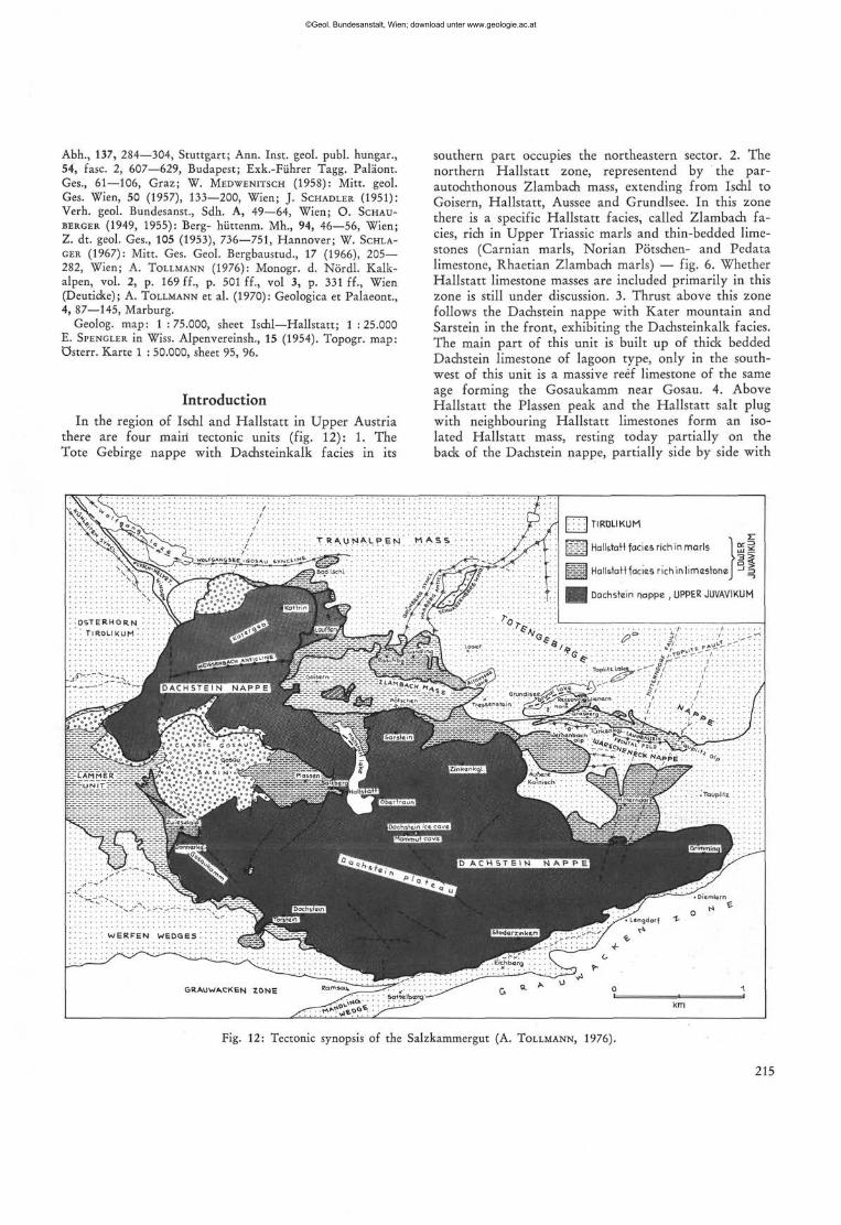
there are four mairi tectonic units (fig. 12): 1. The Tote Gebirge nappe with Dachsteinkalk facies in its
southern part occupies the northeastern sector. 2. The northern Hallstatt zone, representend by the par-autochthonous Zlambach mass, extending from Ischl to Goisern, Hallstatt, Aussee and Grundlsee. In this zone there is a specific Hallstatt facies, called Zlambach facies, rich in Upper Triassic marls and thin-bedded limestones (Carnian marls, Norian Pötschen- and Pedata limestone, Rhaetian Zlambach marls) —- fig. 6. Whether Hallstatt limestone masses are included primarily in this zone is still under discussion. 3. Thrust above this zone follows the Dachstein nappe with Kater mountain and Sarstein in the front, exhibiting the Dachsteinkalk facies. The main part of this unit is built up of thick bedded Dachstein limestone of lagoon type, only in the southwest of this unit is a massive reef limestone of the same age forming the Gosaukamm near Gosau. 4. Above Hallstatt the Plassen peak and the Hallstatt salt plug with neighbouring Hallstatt limestones form an isolated Hallstatt mass, resting today partially on the back of the Dachstein nappe, partially side by side with
[ ] TIRDLIKUM
s a HalMoM facia* rich in marls 25*
S S I Hallstatt facias nch in limestone J =>
Dachstein nappe , UPPER JUVAVIKUM
0 5 I E R H O R N
• ! T IROLIkUM
««rrreaaoswa»
I D A C H S T E I N N A P P E f Gryndl &eC /£•<>*•Z^~W.»
Tre%ser>st«irv f Z ~ / ^
:• --fr; ibpi.itloity.-f!". SA • -
:4S?\::y.Sj:::
- , o ~ ^ '
; O » C L A , 5 5 . C G O S A U
WSSSSSB&SSEL ül-.'i'iTitfUvüJ
W E R F E N W E D Q E S '. SSBSS8S
• Langdor f >
Fig. 12: Tectonic synopsis of the Salzkammergut (A. TOLLMANN, 1976).
215
©Geol. Bundesanstalt, Wien; download unter www.geologie.ac.at
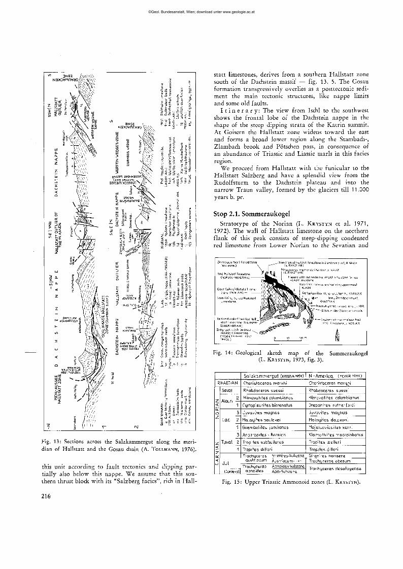
Fig. 13: Sections across the Salzkammergut along the meridian of Hallstatt and the Gosau chain (A. TOLLMANN, 1976).
this unit according to fault tectonics and dipping partially also below this nappe. We assume that this southern thrust block with its "Salzberg fades", rich in Hall-
statt limestones, derives from a southern Hallstatt zone south of the Dachstein massif — fig. 13. 5. The Gosau formation transgressively overlies as a posttectonic sediment the main tectonic structures, like nappe limits and some old faults.
I t i n e r a r y : The view from Ischl to the southwest shows the frontal lobe of the Dachstein nappe in the shape of the steep dipping strata of the Katrin summit. At Goisern the Hallstatt zone widens toward the east and forms a broad lower region along the Stambach-, Zlambach brook and Pötschen pass, in consequence of an abundance of Triassic and Liassic marls in this facies region.
We proceed from Hallstatt with the funicular to the Hallstatt Salzberg and have a splendid view from the Rudolfsturm to the Dachstein plateau and into the narrow Traun valley, formed by the glaciers till 11.000 years b. pr.
Stop 2.1. Sommeraukogel
Stratotype of the Norian (L. KRYSTYN et al. 1971, 1972). The wall of Hallstatt limestone on the northern flank of this peak consists of steep-dipping condensed red limestone from Lower Norian to the Sevatian and
Fig. 14: Geological sketch map of the Sommeraukogel (L. KRYSTYN, 1973, fig. 3).
RHAETIAN
NO
RIA
N
z < z DC
<
Sevat
£
1
3
Lac 2
1
3
Tuva I 2
1
Ju l
(Cordevol)
Sa lzkammergut (KRVSTVNI979)
Choristoceras marshi
Rhabdoceras suessi
Himavatites columbianus
Cyrtopleurites bfcrenatus
Juvavites magnus
Malayites paulckei
Guembeütes jandianus
Anatropites - Bereich
Tropites subbullatus
Tropites dilleri
Trachyceras Sirenites-Subzone austnacum Austriacum- -» -
Trachyceras Aonoides-Subzone aonoides Aon-Subzone
N - America C T O Z E R W O
Choristoceras marshi
Rhabdoceras suessi
Himavatites columbianus
Drepanites rutherfordi
Juvavites magnus
l ia layi tes daujsoni
Mojsisovicsites kerri
Klamathites macrolobatus
Tropites UJelleri
Tropites dilleri
5irenites nansene Trachyceras obesum
Trachyceras desatoyense
Fig. 15: Upper Triassic Ammonoid zones (L. KRYSTYN).
216
©Geol. Bundesanstalt, Wien; download unter www.geologie.ac.at
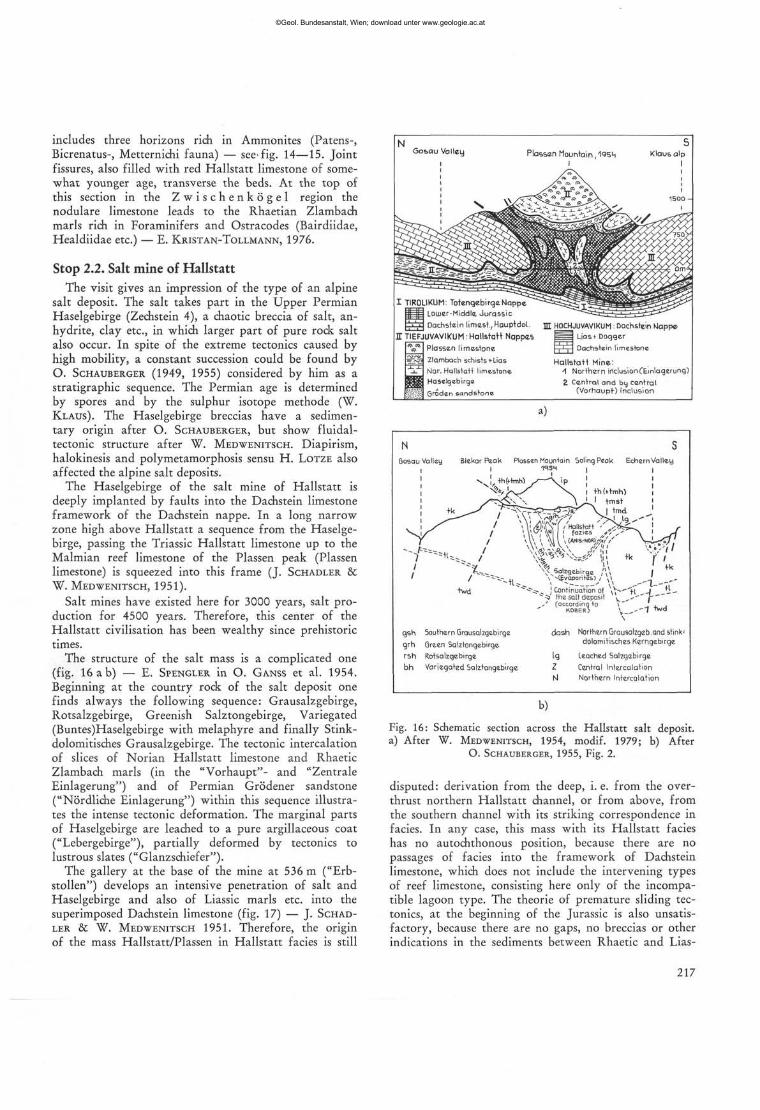
includes three horizons rich in Ammonites (Patens-, Bicrenatus-, Metternichi fauna) — see-fig. 14—15. Joint fissures, also filled with red Hallstatt limestone of somewhat younger age, transverse the beds. At the top of this section in the Z w i s c h e n k ö g e l region the nodulare limestone leads to the Rhaetian Zlambach marls rich in Foraminifers and Ostracodes (Bairdiidae, Healdiidae etc.) — E. KRISTAN-TOLLMANN, 1976.
Stop 2.2. Salt mine of Hallstatt The visit gives an impression of the type of an alpine
salt deposit. The salt takes part in the Upper Permian Haselgebirge (Zechstein 4), a chaotic breccia of salt, anhydrite, clay etc., in which larger part of pure rock salt also occur. In spite of the extreme tectonics caused by high mobility, a constant succession could be found by O. SCHAUBERGER (1949, 1955) considered by him as a stratigraphic sequence. The Permian age is determined by spores and by the sulphur isotope methode (W. KLAUS). The Haselgebirge breccias have a sedimentary origin after O. SCHAUBERGER, but show fluidal-tectonic structure after W. MEDWENITSCH. Diapirism, halokinesis and polymetamorphosis sensu H. LOTZE also affected the alpine salt deposits.
The Haselgebirge of the salt mine of Hallstatt is deeply implanted by faults into the Dachstein limestone framework of the Dachstein nappe. In a long narrow zone high above Hallstatt a sequence from the Haselgebirge, passing the Triassic Hallstatt limestone up to the Malmian reef limestone of the Plassen peak (Plassen limestone) is squeezed into this frame (J. SCHADLER & W. MEDWENITSCH, 1951).
Salt mines have existed here for 3000 years, salt production for 4500 years. Therefore, this center of the Hallstatt civilisation has been wealthy since prehistoric times.
The structure of the salt mass is a complicated one (fig. 16 a b) — E. SPENGLER in O. GANSS et al. 1954.
Beginning at the country rock of the salt deposit one finds always the following sequence: Grausalzgebirge, Rotsalzgebirge, Greenish Salztongebirge, Variegated (Buntes)Haselgebirge with melaphyre and finally Stink-dolomitisches Grausalzgebirge. The tectonic intercalation of slices of Norian Hallstatt limestone and Rhaetic Zlambach marls (in the "Vorhaupt"- and "Zentrale Einlagerung") and of Permian Grödener sandstone ("Nördliche Einlagerung") within this sequence illustrates the intense tectonic deformation. The marginal parts of Haselgebirge are leached to a pure argillaceous coat ("Lebergebirge"), partially deformed by tectonics to lustrous slates ("Glanzschiefer").
The gallery at the base of the mine at 536 m ("Erb-stollen") develops an intensive penetration of salt and Haselgebirge and also of Liassic marls etc. into the superimposed Dachstein limestone (fig. 17) — J. SCHADLER & W. MEDWENITSCH 1951. Therefore, the origin of the mass Hallstatt/Plassen in Hallstatt facies is still
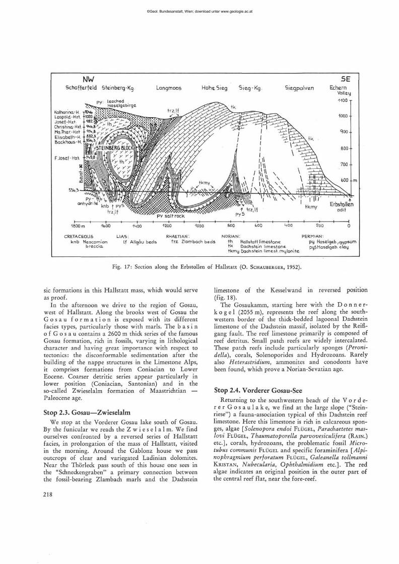
Gosau Valley Plassen Mountain tosh Klaus alp
I TIR0LIKUM: Totengebirge Nappe Loiuer-Middle Jurassic Dachstein limest, Hauptdol
I TIEFJUVAVIKUM: Hallstatt Nappes Plassen limestone
=I~Z] Zlambach schists «-Lias Nor. Hallstatt limestone Haselgebirge Groden sandstone
m HOCHJUVAVIKUM . Dachstein Nappe [ | Lias t Dogger I | I | l Dachstein limestone
Hallstatt Mine: -1 Northern iriclusionCEmlagerung)
Z Cantral and by central (Vorhaupt) inclusion
»)
qsh Southern Grausalzgebirgc grh Green Salztangebirge
rsh Rotsalzgebirge bh Variegated Salz+ongebirge
+h(trmh> tmst | tmd '
i NcdMaH | fazies J?''
® ^ N W ' «J! * N^^5alzgebirgc j\ \
^ ^ j Continuation of \S-,/" f i J t i --•*» the salt deposit ^ ^ ' " f ' J (occordinq +0 \" , . ,
KOBER) V — - " ' ^ \ dash Northern Grausalzgeb.and stink-
dolornttisches Kemgebirge
lg Leached Salzgebirge
Z Central Intercalation M Northern Intercalation
b)
Fig. 16: Schematic section across the Hallstatt salt deposit. a) After W. MEDWENITSCH, 1954, modif. 1979; b) After
O. SCHAUBERGER, 1955, Fig. 2.
disputed: derivation from the deep, i. e. from the over-thrust northern Hallstatt channel, or from above, from the southern channel with its striking correspondence in facies. In any case, this mass with its Hallstatt facies has no autochthonous position, because there are no passages of facies into the framework of Dachstein limestone, which does not include the intervening types of reef limestone, consisting here only of the incompatible lagoon type. The theorie of premature sliding tectonics, at the beginning of the Jurassic is also unsatisfactory, because there are no gaps, no breccias or other indications in the sediments between Rhaetic and Lias-
217
©Geol. Bundesanstalt, Wien; download unter www.geologie.ac.at
NW Schaffexfeld Steinberg-Kg. Langmoos Höh«. Sieg
Katharina- H. Leopold-Hzt Josef-Hzt. Christina-Hzt Ma.lher.-Hzt. Elisabeth-H. Backhaus-H.
F.Josef-Hzt
55b ,-b
1600 m
CRETACEOUS knb Ncocomian
breccia.
-moo
LIAS: Lf Allqäu beds
RHAETIAN' trz. Zlambach beds
NORIAN: PERMIAN'. th Hallstatt limestone py Haselgeb.,gypsum tk Dachstein limestone puS Haselgab. clay tkmy Dachstein limest. mylonite
Fig. 17: Section along the Erbstollen of Hallstatt (O. SCHAUBERGER, 1952).
sic formations in this Hallstatt mass, which would serve as proof.
In the afternoon we drive to the region of Gosau, west of Hallstatt. Along the brooks west of Gosau the G o s a u f o r m a t i o n is exposed with its different facies types, particularly those with marls. The b a s i n o f G o s a u contains a 2600 m thick series of the famous Gosau formation, rich in fossils, varying in lithological character and having great importance with respect to tectonics: the disconformable sedimentation after the building of the nappe structures in the Limestone Alps, it comprises formations from Coniacian to Lower Eocene. Coarser detritic series appear particularly in lower position (Coniacian, Santonian) and in the so-called Zwieselalm formation of Maastrichtian — Paleocene age.
Stop 2.3. Gosau—Zwieselalm We stop at the Vorderer Gosau lake south of Gosau.
By the funicular we reach' the Z w i e s e l a l m . We find ourselves confronted by a reversed series of Hallstatt facies, in prolongation of the mass of Hallstatt, visited in the morning. Around the Gablonz house we pass outcrops of clear and variegated Ladinian dolomites. Near the Thörleck pass south of this house one sees in the "Schneckengraben" a primary connection between the fossil-bearing Zlambach marls and the Dachstein
limestone of the Kesselwand in reversed position (fig. 18).
The Gosaukamm, starting here with the D o n n e r -k o g e 1 (2055 m), represents the reef along the southwestern border of the thick-bedded lagoonal Dachstein limestone of the Dachstein massif, isolated by the Reißgang fault. The reef limestone primarily is composed of reef detritus. Small patch reefs are widely intercalated. These patch reefs include particularly sponges (Peroni-della), corals, Solenoporides and Hydrozoans. Rarely also Heterastridium, ammonites and conodonts have been found, which prove a Norian-Sevatian age.
Stop 2.4. Vorderer Gosau-See Returning to the southwestern beach of the V o r d e
r e r G o s a u l a k e , we find at the large slope ("Stein-riese") a fauna-association typical of this Dachstein reef limestone. Here this limestone is rich in calcareous sponges, algae [Solenopora endoi FLÜGEL, Paracbaetetes mas-lovi FLÜGEL, Thaumatoporella parvovesiculifera (RAIN.)
etc.], corals, hydrozoans, the problematic fossil Micro-tubus communis FLÜGEL and specific foraminifera [Alpi-nophragmium perforatum FLÜGEL, Galeanella tollmanni KRISTAN, Nubecularia, Ophthalmidium etc.]. The red algae indicates an original position in the outer part of the central reef flat, near the fore-reef.
218
©Geol. Bundesanstalt, Wien; download unter www.geologie.ac.at
Carnian Halobia beds
Ladinian Reifling limestone
Anisian-Ladinian dolomite
Sky+hian Werfen beds
Faults
• • •
Fig. 18: Geological sketch map of the Zwieselalp area at the Vorderer Gosau Lake (mainly after W. SCHLAGER, 1967).
(1960, 1976): Jb. Geol. Bundesanst., 103, 37—131, Wien; Monographie d. Nördl. Kalkalpen, vol. 2, p. 501—577; vol. 3, p. 352 ff., Wien (Deuticke). Geol. map 1 : 75.000, sheet Ischl—Hallstatt and Liezen; Topogr. map 1 : 50.000, sheet 96, 97, 126, 127, 128.
Introduction In the region of the eastern Salzkammergut in Styria
one finds east of Bad Aussee the series of two in its fades different Hallstatt zones between the carbonate platform sediments. Because thrusting and faulting characterize this region, the home and origin of the Hallstatt zones has been a subject of fervent disput.
Recently the origin, stratigraphy and tectonics of this region largely has been clarified by new mapping, facies analysis and paleontological survey. The northern Hallstatt zone with its facies rich in Upper Triassic marls have been originated in a northern channel-like basin, the northern Juvavian channel, running from
\&L
Terr, ^S
Quaternary, Pleistocene and Alluvial deposits
Talus slope Senonian toLouuer Tertiary ,Gosau formation
(mar ls, sandstones, conglomerates) Rhaetian, Zlambach beds Dachstein reef limestone Carnian-Norian, Hallstatt l imestone Carnian Cfdaris limestone and Norian
0
Day 3
Tectonics and facies of the Hallstatt Zone in the eastern Salzkammergut
(A. TOLLMANN)
R o u t e : Hallstatt — Mitterndorf — walk across Feuerkugel and Weissenbach alp to Grundlsee — Schlad-ming — Radstadt — Obertauern.
S u b j e c t : The differences between Hallstatt facies rich in limestones and in marls and Dachstein limestone facies are striking in the eastern Salzkammergut because of the strong contrasts within a narrow limited space between Mitterndorf and Grundlsee. Furthermore nappe tectonics and parautochthony of masses in Hallstatt facies can be demonstrated.
R e f e r e n c e s : L. KRYSTYN (1973): Verh. Geol. Bundesanst., 1973, 113—153, Wien; W. SCHÖLLNBERGER (1973): Mitt. Ges. Geol. Bergb. Wien, 22, 95—153, Wien; A. TOLLMANN
219
©Geol. Bundesanstalt, Wien; download unter www.geologie.ac.at
o
Quarternary
Qosau limest.1
+ sandstone
Gosau marl • Senonian
Gosau conql.
Plassen limest. (M.-) U.Malm
Malm limest., io = 0beralm Limestone itr*Tressenstein 1st, ia> Agatha 1st.
Ruhpolding radiolarite (L Malm) and cherty shqies (Dogger)
Klaus limestone (Dogger)
Lias (Allqäu shales, Hierlatz-, Adnet limest.)
Dachstein limest. (Norian-Rhaetian)
Hauptdolomit (Norian)
Zlambach marls (Khaetian)
Pedatabeds, thpk= Ped.limestone, thpd = Pedata dolomite
Hallstatt limest. (Ladin.-Sevatian)
Cidaris limest. (U.Carnian)
Cam. dolomite
Luni sandstone (L.Carnian) Reingraben shales (Halobia-
shales, L.Carnian) Reifung limestone CM.Trias.-L.Cam.)
Schreyeralm limest. (Anisian)
\y/;Yi\ tiud Ramsau dolomite (Ladinian)
| \ j i | i | tmst(k) Steinalm limestone (Anisian)
*»V»| tmd Anisian dolomite
* * * * | tmdz Mineralized Anisian dolomite
Gutenstein limestone (Anisian)
Reichenhall rauhwacke (L.Ani'b.?)
Werfen beds (Skythian)
Haselgebirge (U.Permian)
Route
T N Totengebirge Nappe DN Dachstein N.
I B Zlambach Block (M)HN (Mitterndorf) WN Ldarscheneck Nappe Hallstatt N.
Fig. 19: Geological sketch map of the region between Kainisch and Grundl Lake in Styria (A. TOLLMANN, 1960 and W. SCHÖLLNBERGER, 1974).
©Geol. Bundesanstalt, Wien; download unter www.geologie.ac.at
Goisern to Aussee and Grundlsee. The series of this zone in its specific facies is shown in figure 6. The characteristics of this series in Zlambach facies is the Middle Triassic with Anisian dolomite, Anisoladinian Reifling limestone and the Upper Triassic with a Carnian sequence of shales, sandstone and dolomite (as in the Lunz facies), beginning however with the Norian stage, with typical Hallstatt facies (Putschen- and Pedata limestone), few Hallstatt limestone and Zlambach marls.
In contrast to this development in the northern Juvavian channel are the thrust slices in the region of Mitterndorf, which one can deduce from the southern Juvavian channel. These tectonic outliers, which overly the Warscheneck nappe with its Dachsteinkalk facies, include a series from Permian Haselgebirge to Hallstatt limestone and up to Upper Jurassic limestone. The red Hallstatt limestone starts in this southern channel with the Middle Anisian and shows namely in Carnian and Norian eminent condensation.
The tectonic position of the series of the northern Hallstatt Zone today is explained as parautochthonous, isolated by faults or local thrusts. Facies transitions between the Rhaetic Dachstein limestone of the neighbouring Totes Gebirge and the Zlambach formation of this
northern Hallstatt Zone in Zlambach facies prooves this hypothesis.
I t i n e r a r y : The route from Hallstatt across the P ö t s c h e n p a s s and Aussee to Mitterndorf leads at first along the northern Hallstatt Zone. The view from the curve north of the Pötschen pass shows the Hallstatt limestone mass of Raschberg and the more complete series up to the Malm of the Sandling mountain. Close to the Pötschen pass, in the north one can see the type locality of Pötschen limestone, a typical formation of the Norian in the Zlambach facies zone.
View from the route NW of Aussee to the northern and southern framework of the Hallstatt Zone, the Totes Gebirge with Triassic and Jurassic carbonates in the North and Sarstein and Dachstein as parts of the higher tectonical unit, the Dachstein nappe, in the south.
Stop 3.1. Feuerkogel-Röthelstein March from Äußere Kainisch or Mitterndorf to the
Feuerkogel-Röthelstein-peak, a part of a thrust Hall-statt slice, deriving from the southern Hallstatt channel with Salzberg facies (fig. 19). The base of this massif consists of Jurassic of the Warscheneck nappe, the higher
NNW SSE
scree, soil
Massive light HollslaH limestone (L.NORIAN)
Red bedded Hallstatt limestone (LANGOBARD-L.NORIAN)
Red nodular Hallstatt limestone (LANGObARD, U. LADINIAN)
Grey violett bedded Hallstatt limestone (FASSAN^L.LADINIAN)
Marls (UPPER ANISIAN )
Reifling and Schreyeralm beds (ANISIAN)
M5°
30°
15°
f lat- ly ing
fault
quarry
Position of the section
100 m =J
Fig. 20: Sketch map of the Feuerkogel near Kainisch (L. KRYSTYN, 1979).
221
©Geol. Bundesanstalt, Wien; download unter www.geologie.ac.at

part of a sequence starting with Permowerfenian and reaching up to the Malmian Plassenkalk of the Rötheistein. The Carnian-Norian sequence of Hallstatt Limestone in extreme condensation is exposed in a little quarry on the summit of the Feuerkugel (fig. 20). A section of 2 m thickness offers Julian, Tuvalian and Lower Norian, the latter with a level of Halobia styriaca Mojs. This quarry represents one of the most famous places at all, were ammonites have been found. Already in the classic era of investigation 464 species of cephalopodes, 78 of gastropodes and many other elements have been described from this locality.
The quarry on the northern side of the Feuerkogel (fig. 21, 22) shows similar to the summit a condensed Hallstatt limestone sequence of Upper Carnian and Lower Norian with sedimentary tilting and discordance.
Fig. 21: Stratigraphic sequence of the Hallstatt limestone in the quarry F 1 on the Feuerkogel near Kainisch (L. KRYSTYN,
1979).
m 2 -
1 -
0 -
<NJ
i! T -
Lac
o •>
t±
(M
—• ~3
<*1 c-> H •
.. c ort
P -•.o
Z < K O Z
2 a: <• u => Z < ? < u _J
2 < Z
o < _ i
1
sn -
1
1
SSL
-
1
1
r\
\
1
i
B f
1
• 70/79
• 70/50 Halobia styriaca
Halobia austriaca
• 70/78
' 7 ° / f e 7 Subsolution Horizon Luith
Trachyceras austriacum Ammonites layer
Reaf of Foraminifera
Condensation horizon Luith Trdchyceras aanoidcs + Daonella tommeli
auARRy P I
Fig. 22: The quarry F 4 on the Feuerkogel (L. KRYSTYN, 1979).
Stop 3.2. Weißenbach alp The following way across the Weißenbach alp crosses
the basal conglomerate of the Gosau formation. The equivalent of this Lower Senonian (Coniacian) conglo-merat covers with transgressive contact the nappe limits and prooves so the pre-Senonian age of nappe formation in the Limestone Alps.
Stop 3.3. Grasberg pass Northeast of the Weißenbach alp we meet the thick
bedded Upper Triassic Dachstein limestone of the underlying Warscheneck nappe. This type of lagoonal formation, today in the tectonic vicinity of the basin-type of Hallstatt limestone gives a good impression of facies contrast, intensified by tectonics. We see the third facies of the same age, the Zlambachfacies with the Norian Pedata limestone just beyond the Tiirkenkogel ridge near the G r a s b e r g p a s s . Finally, before reaching the Grundlsee, we cross near Wienern the Haselgebirge rich in gypsum and anhydrite, which forms the base of a next tectonic outlier (fig. 23).
Our bus passes Irdning, Schladming and Radstadt. It turns round the Dachstein massif. The G r i m m i n g mountain W of Irdning offers a nice frontal lobe in thick bedded Dachstein limestone. The view from the Enns valley includes to the north at the base the shales of the Grauwackenzone, characterized by the gentle morphology, and above the steep walls of the Dachstein massif, formed mainly by Ramsau dolomite and Dachstein limestone. At Mandling one crosses a slice (Mandlingspan) of the Limestone Alps, technically planted into the Grauwackenzone.
The route from R a d s t a d t to Obertauern reaches the Lower Austroalpine unit soon after leaving the Enns valley. Before reaching Untertauern we drive through the monotonous masses of Paleozoic quartz phyllite of the uppermost nappe of this system. The lower nappes of the Lower Austroalpine with masses of Mesozoic carbonates appear southward from Untertauern, at first with a dark, thick bedded Anisian dolomite.
Day 4
The Lower Austroalpine of the central Radstadt Tauern in the Pleisling range
(A. TOLLMANN)
R o u t e : Obertauern — Wisenegg — Felseralm — Wildsee — Teufelskar — Obertauern/Lungau, Salzburg. Mainly march.
S u b j e c t : Stratigraphy, fossils, facies, metamorphosis and tectonic style of the Lower Austroalpine system as shown by the Pleisling nappe in the Pleisling range near Obertauern. Excellent outcrops in rocky
222
©Geol. Bundesanstalt, Wien; download unter www.geologie.ac.at
© WAR5CHENE.CK NAPPE
ZLAMBACH . WEDGE . .]> Tirkankogal
Grasbcrg .. \\ , '
TOTENGEBIRGE N . ZLAMBACH ( W A R S C H E N E C K N . ^ M I T T E R N D O R F E R HALLSTATT N A P P E UNIT WaifScnbachkg. Schnötaritzkg.-ty
Fig. 23: Sections between Kainisch and Grundl Lake (A. TOLLMANN 1960 and W. SCHÖLLNBERGER 1974).
terrain. The huge recumbent folds directed toward the north, here in the framework of the Tauern window, have been of great importance improoving the existence of this window.
R e f e r e n c e s : W. SCHWAN (1965): Verh. geol. Bundesamt., Sdh. G, 214—245, Wien; A. TOLLMANN: Ibid., 1956, 146—164; Mitt. geol. Ges. Wien, 57 (1964), 49—56; Geologie v. Österreich, vol. 1, p. 101—131, Wien (Deuticke) 1977. — Topogr. maps: österr. Karte l : 50.000, sheet 156, 157.
Introduction The Radstadt Tauern (Fig. 24) are the best exposed
and most extensively studied region of the Lower Austroalpine system in Austria, with a series most plentiful in formations and fossils. The Mesozoic sequence represents the type of the wide spreaded, so-called "Centralalpine" facies, a development in distinct contrast to the "Northalpine" facies of the Limestone Alps. It is possible to determine the fossils inspite of the alpidic metamorphosis in greenschist facies, however, the mobility attained was such, that today impressive tectonic structures can be studied. The highest temperature during this metamorphosis was 450° at 4— 4,5 kbar, as indicated by the development of cyanite and chloritoide.
Fig. 6 shows the stratigraphic sequence. The Pleisling nappe includes in the central part of the Radstadt Tauern a Permomesozoic series approximately 1750 m thick, which comprises formations from Permian Alpine Verrucano to the Upper Jurassic radiolarite. The main rocks, determining the morphological character as rocky, are the 300 m thick Ladinian Wetterstein dolomite and the 500 m thick Norian Hauptdolomit.
Of interest is the facies of this series. In comparison with the facies of the Northern Limestone Alps the centralalpine facies is characterized by the following facts: less thickness, less fossiliferous, more paradia-genetic breccias in Triassic and Jurassic demonstrating an increased mobility of crust. These are the specific differences: the Permian consists of quartzites and seri-citic-phengitic schists and not of Haselgebirge (with salt and gypsum); the Werfenian consists of Lantschfeld quartzites instead of "Werfen schists; the Middle Triassic shows throughout the whole of the Central Alps a striking uniformity instead of the great variability of this epoch in the Limestone Alps. The Lower Jurassic shales are very typical, resembling the Penninic "Schistes lustres", which comprises, in contrast to the Limestone Alps, generally a considerable amount of dolomite sand and dolomite breccias. Jurassic sand-
223
©Geol. Bundesanstalt, Wien; download unter www.geologie.ac.at
Preunegg Schladming
UPPER AU5TR0-ALPINE: '—~1 Brauwackenzone.LouierPaleazoi
MIDDLE AUSTRO-ALPINE: Permo-Triassic Crystalline
**zz?
LOWER AUSTRO-ALPINE: Quartz Phyllite Nappe: Permo-Triassic Quartz Phyllite Nappe. Quartz Phyllite
Kesselspitz Nappe: Crystalline and Permo-Triassic Pleisling Nappe: Perrno-Mesozoic Rauhwacken Uzdge: Tnassic Hofalm Slice: Crystalline and Permo-Triassic Lantschfeld Nappe: Permo-Tnassic Lantschfeld Nappe:Crystalline
I I I I I I Hochfeind Nappe: Permo-Mesozoic JjSfflJ Hochfeind Nappe: Crystalline imiUU Speiereck Nappe and lowermost wedges
PENNINE: l ~ ~ l Schieferhülle.: Post-Triassic
Fig. 24: Position and nappe structure of the Lower Austroalpine unit in the Radstadt Tauern (A. TOLLMANN, 1977, fig. 30).
stones and sandy slates are very rare in the Limestone Alps and bear only quartzsand.
Furthermore facies differences of subordinate importance can be found between the nappes within the Radstadt Tauern, so that the "Hochfeind facies" in the south includes a much higher content of breccias in Jurassic and Lower Cretaceous than the "Pleisling facies" in the central part of these mountains.
From the tectonic point of view the generally position is remarkable at first: the masses of light Mesozoic dolomites are in strong contrast to the dark shales of Penninic Schieferhülle below (SW) and to the dark crystalline sheet of the overthrust Middle Austroalpine above (NE, E) — surprisingly not only for the geologist. This specific position can only be explained by the nappe theory. The splendid survey of the regional
depression of the Lower Austroalpine system below the Altkristallin here at the northeastern corner of the Tauern Window must be stressed. The Middle Austroalpine unit is thrust in an upright, non-inverted position and with diaphthoresis of its base above the Radstadt Tauern. The huge recumbent folds in the Pleisling nappe, especially those of the Schwarze Wand (see fig. 31), show the movement towards the north.
Position and structure of the Radstadt Tauern are shown by figure 24, 25. One distinguishes six nappes from bottom (S) to top (N): Speiereck-, Hochfeind-, Lantschfeld-, Pleisling-, Kesselspitz- and Quarzphyllit nappe. All these sheets — except the last — have series of upright, non-inverted position, although some show huge recumbent folds as internal structure. NE of the Tauern pass the Middle Austroalpine crystalline pierces
224
©Geol. Bundesanstalt, Wien; download unter www.geologie.ac.at
SI9NÄTUKE: E3SchieforhüllefPerminlc) ! • »lTw«wa Crnsipllint\:.'-::\ ikyfhian l ~ - I rriassicPPZr S ä Nteeamlan l " l Ouarti phtjllite \* + \ Crystallina
Fig. 25: Schematic section of the Radstadt Tauern in Salzburg (A. TOLLMANN, 1964).
by digitation into the tectonic substratum, which formes a great bads fold in the Kalkspitzen peaks — with bright dolomites contrasting to the surrounding dark crystalline rocks.
The difference in plasticity between the more rigid dolomite and the more mobile limestones, shales and quartzites in this lower level of alpine orogenesis is manifested clearly by the varability of fold structures, attaining in some cases flow fold characteristics. The fault structures have no importance.
Stop 4.1. Felser alp
The path from Wisenegg to Felser alp leads along a Carnian series rich in dolomites, breccias, shales, accompanied in the south by a reversed younger series above. The outlook towards north shows the superposition of the reversed quartz phyllite nappe (Scheck, Spatzeck) and Middle Austroalpine crystalline (Seekar-spitze) above the Pleisling nappe.
SPARTZ PHYLLITE NAPPE 17fc9(ScneclO Johannes eaicad«
P L E S L I N G moin crest luoo
E|NW
N A P P E Zehner karsp 2575 6om5le.ilensp.2i57
5E
KESSELSPITZ NAPPE Schwarze Wand Kesselsp 2Sfa2.
D o g g e r - ? sch is ts tc r ino ida l l imesione Lias pyr i t - i ferous s h a l e
L ias L imes tone . Upper ß h a e t ' i a n l i m e s t o n e R h a e t i q n , Kossen b e d s
H a u p t d o l o m i t e O d ) C a r n i a n / R a i b l b r e c c i a Carnian, d o l . « do l . sc ln is ts CRaibl b e d s )
Ca rn ian , p y r i t i f e r o u s s h a l e Cordevo l , R q r t n a c h M r 1 b e r g d o l o m i t e
l a d i n i a n , U e t t e r & t e i n d o l . Upper A n i s i a n , T r a c h H « s d o l . o l a c k - g r e y A n l s i a n d o l o m i t e A n i s ' t a n , l i m e s t o n e A n i s i a n , p y r i V i f e r o u s s h a l e
R a u h i u a c k e U.Skyth-, /UpRho«.t ian Shale 5ky th ian ,LaMscU{e ld quart* F o s s i l e s
Fig. 26: Section across the Pleisling nappe in the central Radstadt Tauern (A. TOLLMANN, 1956).
15 Geol. Bundesamt., Abh., Bd. 34 225
©Geol. Bundesanstalt, Wien; download unter www.geologie.ac.at
226
©Geol. Bundesanstalt, Wien; download unter www.geologie.ac.at
v,ra
A
kb
kq
ia
ih
ihS
iS
id
lib
lis
lb
iq
IS
IkS
Ik
Talus, Alluvium
Moraines
Malm/Loiuer Cretaceous Schu>arz= eck breccia
Loiuer Cretaceous Schiuarzeck quartzite schists
LotuerMalm „Aptychus" limestone
LoiüerMalm radiolarite Cchert)
Loiuer Malm quartzite schists
Dogger/LMalm banded slates
Dogger Crinoideslimestone
Lias/Dogger breccia
Lias/ Dogger banded slates
Lias breccia
Lias quartzite
Lias shales/slates
Lias calc-slates
Lias calk-marble
rdS
to
td
trkd
trk
tr
tdk
td
tlrh
tld
tldS
tlk
tIS
tpd
tpS
tuid
Triassic dolomite-schists
Triassic dolomite
Triassic limestone
Upper Rhae+ian dolomite
Upper Rhaeti an limestone
Rhaetian kössen beds
Norian Plattenkalk
Norian Hauptdolomit
Carnian rauhiuacke
Carnian dolomite
Carnian dolomitic schists
Carnian limestone
Carnian slates
LouierCarnian Partnach/Arlberg dolomite
LoiuerCarnian Rartnach slates
Ladinian Ldetterstein dolomite
tmd
tmdS
tmk
tmS
t rh
tqS
fq
ts
pq
Krist
9
Dip
Anisian Trochites dolomite
Anisian dolomitic schists
Anisian banded limestone („Muschelkalk")
Loiuer Anisian basal slates
Loiuer Anisian rauhiuacke
Upper Skythian Alpine Röt schists
Skythian Lantschfeld quartzite
Permoskythian quartzite-schists
Permian Alpine Verrucano
Tuuengcrystallineislfces of sedimentary rocks
Fossils
angles of beds: a "15°
- f 4 - - i - 4 - ^ - A - ^ - - t -
Dip angles of axis'.
Fig. 27: Geological sketch map of the area visited in the Pleisling massif (Original). PN = Pleisling Nappe, KN = Kesselspitz nappe. Legend to figs. 27—34.
Stop 4.2. Wildsee The ascent from the Felseralm to Wildsee passes
through a reversed series (Fig. 26). Along the path one can study the reversed section with Liassic shales with an impression of Penninic "schistes lustres" at the bottom, followed by fossiliferous Rhaetic limestones of Koessen beds, then the tectonical reduced Norian Hauptdolomit, finally the Carnian dolomites and sandstones on top. The Cordevolian (lowermost Carnian) is represented by well-bedded dolomites, the Ladinian by Wetterstein dolomite full of remainders of the algae Diplopora annulata (SCHAFH.). The Anisian comprises cherty limestones, banded limestones and such with dolomite nodules. At the bottom of the Anisian dark dolomitic schists with Costatoria costata (ZENKER) appear. The uppermost Werfenian consists of sericite schists of Alpine Roet, the rest of this stage of Lantschfeld quart-zites. Along the lake Wildsee the intensive folding of basal Triassic formations is impressing.
Stop 4.3. Teufelshörner Rising from Wildsee to the Teufelshörner circus one
surveys the better developed Upper Triassic of the
following non-reversed series of the next recumbent fold. It consists in the region of Teufelshörner (fig. 27) and in the circus east of this peak of Hauptdolomit, fossiliferous Koessen beds of Rhaetic age, fossiliferous greyblue thick-bedded Upper Rhaetic limestones with Thecosmilia, gasteropodes and megalodontes, yellowish Liassic marble with Isocrinus cf. basaltiformis (MILL.), and finally, very thick Liassic shales, containing dolomitic sand and some belemnites. The Koessen beds in the Teufelshorn circus bear the most abundant fauna with Thecosmilia clathrata EMMR., Tb. oppeli Rss., Th. bavarica FRECH, Astraeomorpha crassisepta Rss., Oppelismilia rudis (EMMR.), Stylophyllum paradoxum FRECH, St. irreguläre FRECH, St. zitteli FRECH, "Stepha-nocoenia" schafhäutli WINKL., Isocrinus bavaricus WINKL., Triadocidaris lungauensis TOLLM. etc.
In the walls of the socle of Z e h n e r k a r s p i t z e one distinguishes the fold structure of the Teufelshorn syncline and a thrust sheet consisting of Ladinian-Carnian dolomit of the Kesselspitz nappe, forming the top of this peak (fig. 28—29). Dolomite slices of this Kesselspitz nappe are scattered in the Jurassic shales below the thrust plane. At the Mitterriegel one notices an isolated upfold of Hauptdolomit, dividing the big
15* 227
©Geol. Bundesanstalt, Wien; download unter www.geologie.ac.at
Fig. 28: The Teufelshörner in the Radstadt Tauern, view from west (A. TOLLMANN, 1977). Legend see fig. 27.
Fig. 29: The Teufelshörner, view from east (Original). Legend see fig. 27.
228
©Geol. Bundesanstalt, Wien; download unter www.geologie.ac.at
Garnsspitze Zehnerkarspitze Teufalskar
K E S S E L S P I T Z N A P P E
GIOCKNERIN syiMCL.
= 0
JEUFELSHORN SYNCUNE
r ioand
m o r a i n e A A A
Fig. 30: The western wall of the Zehnerkar peak in the Radstadt Tauern (A. TOLLMANN, 1958). Legend see fig. 27.
Teufelshörner syncline into two parts. The prolongation of this dolomite lamella can be seen on the top of the Teufelshörner.
Stop 4.4. Zehnersattel Advancing to the Zehnersattel pass one sees the
beautiful panorama of the Zehner circus, which shows the upper part of the folded Pleisling nappe and remains of the Kesselspitz nappe (fig. 30) — compare also fig. 26. The recumbent fold of S c h w a r z e W a n d with bright dolomite and black shales of Carnian in its core demonstrates the main direction of tectonic transport towards the north (fig. 31). This fact is important, because for decades the autochthonists, who refused the existence of the Tauern Window, postulated a southward direction of movements to explain the supperposition of units here in the northeastern framework of the Tauern Window by local overwhelming. On the summit of the Kesselspitze as on the Zehner-karspitze an analogous remain of the Kesselspitz nappe is preserved. This Anisian portion of the dolomite is proven by Encrinus liliiformis (LAM.) and Entrochus silesiacus BEYRICH.
Day 5
Lower Austroalpine unit in the southern part of the Radstadt Tauern within the Hochf eind range
(A. TOLLMANN)
R o u t e : Obertauern — Tweng — Lantschfeld valley Schwarzsee cirque Re-— Fuchs alp — Schwarzsee cirque — Obertauern.
gion of Lungau in Salzburg. Mainly march.
S u b j e c t : Characteristic breccias and "Wildflysch" of the late stage of gepsyncline, Hochfeind facies in the lowermost tectonic units of the Radstadt Tauern, Jurassic and Cretaceous sedimentation in the Lower Austroalpine unit. Micro- and macrotectonics.
R e f e r e n c e s : E. CLAR (1937): Sitzber. Akad. Wiss. Wien, math.-natw. Kl., I, 146, 249—316, Wien; A. TOLL-MANN: Verh. geol. B.-A., 1959, A 91—95; Mitt. geol. Ges. Wien, 53 (1960), 117—131; Geologie v. Österreich, vol. 1, p. 108 ff. (Wien 1977). Topogr. map: österreichische Karte 1 : 50.000, sheet 156.
Introduction The southern range of Radstadt Tauern indicates the
individual facies of the lowermost unit of the Lower
229
©Geol. Bundesanstalt, Wien; download unter www.geologie.ac.at
Austroalpine. In contrast to the Pleisling facies mentioned above one finds here an enormous abundance of breccias within the Jurassic and Lower Cretaceous. In fact, this part of the Lower Austroalpine system resembles the Penninic trough wich formerly adjoined it and was divided partially by the Lungau rise.
The stratigraphic development within the Triassic sequence of the Hochfeind range resembles that of the Pleisling range, up to the Upper Rhaetic limestone rich in megalodonts, which will be demonstrated in the background of the Schwarzsee circus (see fig. 6). Vigorous movements at the beginning of Liassic lead to eminent unconformities, so that locally the Liassic breccias directly overly Hauptdolomit. Above all the Liassic is marked by a thick mass of breccias, called Türken-kogel breccies. It comprises coarse types with components and blocks of dolomite, limestone and quartzite with indications of mass-flow mechanism, but also levels of dolomitic and quartzitic sandstone. The formation of this type of breccias continues during the Dogger. Within the Lower Malm laminated radiolarites with manganese ore were formed, which characterize a deep sea basin. Inspite of the metamorphism the structure and also the red colour of this radiolarites is preserved locally, radiolarians have been identified in thin sections. A layer of marble within this radiolarite is called "Aptychenkalk".
The series beyond, belonging to the higher Malm and the lower Cretaceous, consist of an alternation of immature sandstones and coarse breccias. The content of crystalline components increase in the upper part more and more. The most impressive phenomena of this late-and post-malmian "Schwarzeck breccias" are gigantic sedimentary blocks in dimensions of houses or hills, mostly composed of dolomites. The sedimentary (and not tectonic — as believed in the past) origin is docu-mentated by a scattering of the marginal zone of these blocks, deposited in the clastic sediment. This phenomenon demonstrates the important role of the young-Kimmerian phase.
Also in the Hochfeind range the main tectonic feature aside from nappe structure is folding in a northern direction. At the Hochfeind and Schwarzeck peak the younger series are preserved in huge synclines, closed to the south. In the sector visited around the lake Schwarzsee the microtectonic structure shows a distinctly selective character depending on the lithofacies: the radiolarite of high mobility forms impressive flow folds; the differences between the soft shales and the brittle dolomites strike just in this tectonic position. Back folding towards SE is only of local importance.
Stop 5.1. Lantschfeld valley Along the route from Tweng to the Lantschfeld valley
one finds outcrops of Werfenian and Anisian of the Lantschfeld nappe north of Ambroshiitte. The ascent to the Fuchsalm crosses the Altkristallin at the base of
©Geol. Bundesanstalt, Wien; download unter www.geologie.ac.at
Vsscree A= moraine 1 -*
Fig. 32: Geological map of the Fuchs circus in the southern range of Radstadt Tauern (Original). H N = Hochfeind nappe, LN = Lantschfeld nappe. Legend see fig. 27.
©Geol. Bundesanstalt, Wien; download unter www.geologie.ac.at
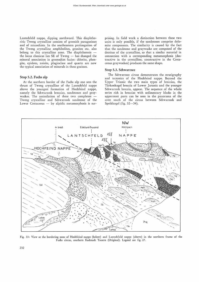
Lantschfeld nappe, dipping northward. This diaphtho-ritic Tweng crystalline consists of greenish paragneisses and of micaschists. In the southeastern prolongation of the Tweng crystalline amphibolites, granites etc. also belong to this crystalline zone. The diaphthoresis — the locus classicus lies SE of Tweng — has changed the mineral association in greenschist facies: chlorite, phen-gite, epidote, zoisite, plagioclase and quartz are now the typical association of minerals in these gneisses.
Stop 5.2. Fuchs alp
At the northern border of the Fuchs alp one sees the thrust of Tweng crystalline of the Lantschfeld nappe above the youngest formation of Hochfeind nappe, namely the Schwarzeck breccias, sandstones and gray-wackes. The assimilation of these two complexes — Tweng crystalline and Schwarzeck sandstone of the Lower Cretaceous — by alpidic metamorphosis is sur
prising. In field work a distinction between these two units is only possible, if the sandstones comprise dolomite components. The similarity is caused by the fact that the sandstone and graywacke are composed of the detritus of the crystalline, so that a similar material in connection with a corresponding metamorphosis (destructive in the crystalline, constructive in the Cretaceous graywackes) produces the same shape.
Stop 5.3. Schwarzsee The Schwarzsee circus demonstrates the stratigraphy
and tectonics of the Hochfeind nappe. Beyond the Upper Triassic the two main types of breccias, the Tiirkenkogel breccia of Lower Jurassic and the younger Schwarzeck breccia, appear. The sequence of the whole series rich in breccias with sedimentary blocks in the uppermost parts can be seen in the panorama of the crest south of the circus between Schwarzeck and Speikkogel (fig. 32—34).
-4-mbO Edaliiieilbiuqnd
\ L A N T 5 C H F E L D m
NW Kämpen
N A P P E
Fig. 33: View at the bordering zone of Hochfeind nappe (below) and Lantschfeld nappe (above) in the northern frame of the Fuchs circus, southern Radstadt Tauern (Original). Legend see fig. 27.
232
©Geol. Bundesanstalt, Wien; download unter www.geologie.ac.at

Day 6
CM
J3
Middle Austroalpine and Gurktal nappe east of the Tauern Window
(A. TOLLMANN)
R o u t e : Obertauern — Mauterndorf — St. Michael — Katschberg — Innerkrems — Eisentalhöhe — Karlbad — Innerkrems — Spittal/Drau — Villach —
% Hermagor. Provinces: Salzburg, Carinthia. Bus drive "g and a march near Innerkrems. ä> S u b j e c t : Eastern border of the Tauern Window.
>-j Prolongation of the Lower Austroalpine in the Katsch-^ berg zone. Middle Austroalpine crystalline and its sedi-•gj, m e n t a r y cover of the S tanga lm Mesozoic. The western £ border of the Upper Austroalpine Gurktal nappe and ""*• the tectonic slice of Lician facies, representing an in-"| voluted Upper Austroalpine chip of the Drauzug near
Innerkrems. Drauzug and Gailtal fault.
R e f e r e n c e s : N. ANDERLE: Geolog. Karte von öster-"u reich 1 : 50.000, sheet 200 Arnoldstein; R. v. BEMMELEN "3 (1961): Jb. Geol. B.-A., 104, 213—237, Wien; E. COLINS et al. "8 (1979): Mitt. Ges. Geol. Bergbaustud. österr., 25 (1978), 1— g 10, Wien; Ch. EXNER (1954, 1971): Jb. Geol. B.-A., 97,
•g 17—37; Ib id . 114 (1971), 1—119, W i e n ; E. K R I S T A N - T O L L -U M A N N et al . (1963) : Mi t t . geol. Ges. Wien, 56, 539—589 , W i e n ;
JB K. LIEGLER (1970): Carinthia II, 160, 27—44, Klagenfurt; J. PISTOTNIK (1974): Mitt. geol. Ges. Wien, 66—67, 127—141, Wien; H. STOWASSER (1956): Jb. Geol. B.-A., 99, 75—199,
53 Wien; A. TOLLMANN: Mitt. Ges. Geol. Bergbaustud. österr. , 3 9 (1958), 57—73; N . Jb. Geol. Pal. Abh., 150 (1975), 19—43,
Stuttgart; Geologie von Österreich, vol. 1 (Wien, Deuticke, "3 1977), p. 131 ff., 309—329, 588—643. — Topogr. maps: I österr . Karte 1 : 50.000, sheet 157, 182, 183!, 199, 200. n
5 Introduction
3 This day gives insight into the situation along the eastern framework of the Tauern Window. It gives a
"g review about the three nappe systems of the Austro-*g alpine unit, which succeed one the other like the peels of gjj an onion, visible here in consequence of the eastward § dipping culmination of the Tauern. a The first part of the excursion route leads exactly | along the narrow Lower Austroalpine zone at the <u eastern border of the Tauern Window. The nappe sy
stem of the Radstadt Tauern is prolongated in its Meso-° zoic series beyond Mauterndorf still to St. Michael, 5 where is ends by tectonic lamination. Only the reverts sed highest unit, the Quartzphyllite nappe, continues •+ with its monotonous phyllites and few lenses of Pa
leozoic dolomites and limestones (with conodonts of E Upper Silurian) southward across the Katschberg pass
to Rennweg and further on to Gmünd in Carinthia. This prolongation of the Lower Austroalpine is called the Katschberg Zone.
It is overthrust by the vast mass of Middle Austroalpine crystalline, which joins at the east. NE of Mauterndorf this Altkristallin consists mainly of paragneis-
233
©Geol. Bundesanstalt, Wien; download unter www.geologie.ac.at
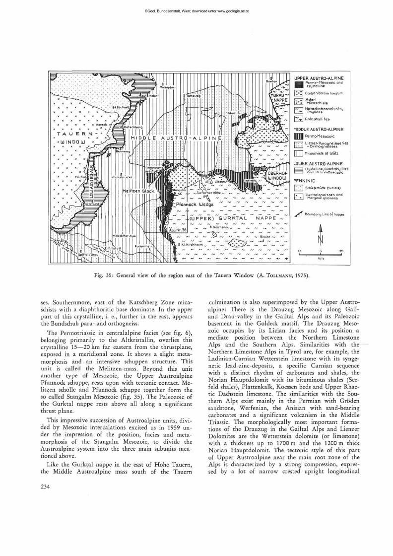
UPPER AUSTRO-ALPINE
•Pcrmo-Mesozoic ond Crystalline
[o°ol Carboniferous Conglom.
fr~71 Acktrl \ ' * ' \ Micaschists
f~ I Mafadiabqsschists, I i d Phyllitzs
l ^ l Calcphyllitas
MIDDLE AUSTRO-ALPINE
| [Tl Rzrmo-rlesozciic-
FFT7] Lieser~Paragn<ziS5cries l'l-l-l + Orthogneisses
• T\ tlicaschists of Wälz
LOUER AUSTRO-ALPINE I l Crystqlhna, EluarUphyHiles I I ond Pcrrno-Mcsozoic
P E N N I N I C
[ '. • 1 | Schief er hO tie (Schist*)
f"i | Zcn t ra lqne isses and I * I Marginal gneissas
j * ^ Boundary Lina, of nappe-
A
N i . i
Fig. 35: General view of the region east of the Tauern Window (A. TOLLMANN, 1975).
ses. Southernmore, east of the Katschberg Zone mica-schists with a diaphthoritic base dominate. In the upper part of this crystalline, i. e., further in the east, appears the Bundschuh para- and orthogneiss.
The Permotriassic in centralalpine facies (see fig. 6), belonging primarily to the Altkristallin, overlies this crystalline 15—20 km far eastern from the thrustplane, exposed in a meridional zone. It shows a slight metamorphosis and an intensive schuppen structure. This unit is called the Melitzen-mass. Beyond this unit another type of Mesozoic, the Upper Austroalpine Pfannock schuppe, rests upon with tectonic contact. Me-litzen schölle and Pfannock schuppe together form the so called Stangalm Mesozoic (fig. 35). The Paleozoic of the Gurktal nappe rests above all along a significant thrust plane.
This impressive succession of Austroalpine units, divided by Mesozoic intercalations excited us in 1959 under the impression of the position, facies and metamorphosis of the Stangalm Mesozoic, to divide the Austroalpine system into the three main subunits mentioned above.
Like the Gurktal nappe in the east of Hohe Tauern, the Middle Austroalpine mass south of the Tauern
culmination is also superimposed by the Upper Austroalpine: There is the Drauzug Mesozoic along Gail-and Drau-valley in the Gailtal Alps and its Paleozoic basement in the Goldeck massif. The Drauzug Mesozoic occupies by its Lician facies and its position a mediate position between the Northern Limestone Alps and the Southern Alps. Similarities with the Northern Limestone Alps in Tyrol are, for example, the Ladinian-Carnian Wetterstein limestone with its synge-netic lead-zinc-deposits, a specific Carnian sequence with a distinct rhythm of carbonates and shales, the Norian Hauptdolomit with its bituminous shales (See-feld shales), Plattenkalk, Koessen beds and Upper Rhae-tic Dachstein limestone. The similarities with the Southern Alps exist mainly in the Permian with Gröden sandstone, Werfenian, the Anisian with sand-bearing carbonates and a significant volcanism in the Middle Triassic. The morphologically most important formations of the Drauzug in the Gailtal Alps and Lienzer Dolomites are the Wetterstein dolomite (or limestone) with a thickness up to 1700 m and the 1200 m thick Norian Hauptdolomit. The tectonic style of this part of Upper Austroalpine near the main root zone of the Alps is characterized by a strong compression, expressed by a lot of narrow crested upright longitudinal
234
©Geol. Bundesanstalt, Wien; download unter www.geologie.ac.at
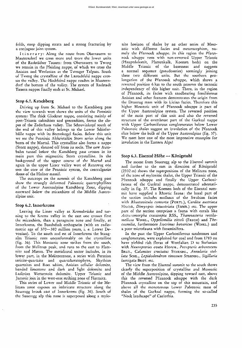
folds, steep dipping strata and a strong fracturing by a conjugate joint system.
I t i n e r a r y : Along the route from Obertauern to Mauterndorf we cross more and more the lower units of the Radstädter Tauern: from Obertauern to Tweng we remain in the Pleisling nappe, of which, we cross the Anisian and Werfenian at the Twenger Talpass. South of Tweng the crystalline of the Lantschfeld nappe crosses the valley. The Hochfeind nappe reaches in Mauterndorf the bottom of the valley. The system of Radstadt Tauern nappes finally ends at St. Michael.
Stop 6.1. Katschberg Driving up from St. Michael to the Katschberg pass
the view towards west shows the units of the Penninic system: The thick Glockner nappe, consisting mainly of post-Triassic calcschists and greenschists, forms the slopes of the Zederhaus valley. The Schrovinkopf south of the end of this valley belongs to the Lower Schieferhülle nappe with its Brennkogel facies. Below this unit we see the Penninic Altkristallin Storz series along the bents of the Murtal. This crystalline also forms a nappe (Storz nappe), sheared off from its socle. The new Autobahn tunnel below the Katschberg pass crosses in its main part this migmatitic Storz crystalline. In the background of the upper course of the Murtal and again in the upper Lieser valley west of Rennweg one sees the core of the Penninic system, the centralgneiss dome of the Hafner massif.
The outcrops on the summit of the Katschberg pass show the strongly deformed Paleozoic quartzphyllites of the Lower Austroalpine Katschberg Zone, dipping eastward below the micaschists of the Middle Austroalpine unit.
Stop 6.2. Innerkrems Leaving the Lieser valley at Kremsbrücke and tur
ning to the Krems valley in the east one crosses first the micaschists, than a paragneiss zone and finally, at Innerkrems, the Bundschuh orthogneiss (with an radiometric age of 370—380 million years, i. e. Lower Devonian). To the south and est of Innerkrems the Stang-alm Triassic rests unconformably on the crystalline (fig. 36). This Mesozoic zone strikes from the south, from the Melitzen peak, and runs to the east to Flatt-nitz and Murau. The meridional sector includes, in its lower part, in the Melitzenzone, a series with Permian sericite-quartzite and quartzkeratophyre, Skythian quartzites and Roet schists, Anisian cellular dolomite, banded limestone and dark and light dolomite and Ladinian Wetterstein dolomite. Upper Triassic and Jurassic join in the west-east striking zone of Flattnitz.
This series of Lower and Middle Triassic of the Melitzen zone exposes an imbricate structure along the Saueregg brook east of Innerkrems (fig. 36). South of the Saueregg alp this zone is superposed along a mylo-
nite horizon of shales by an other series of Mesozoic with different facies and metamorphism, namely the Pfannock schuppe. In this region the Pfann-nock schuppe rests with non-reversed Upper Triassic (Hauptdolomit, Plattenkalk, Koessen beds) on the Middle Triassic of the basement and suggests a normal sequence (pseudoseries) seemingly joining these two different units. But the southern prolongation of the Pfannock schuppe, which shows a reverted position 6 km to the south prooves the tectonic independency of this higher unit. There, in the region of Pfannock, its facies with sandbearing fossiliferous Anisian and other features demonstrates the origin from the Drauzug mass with its Lician facies. Therefore this higher Mesozoic unit of Pfannock schuppe is part of the Upper Austroalpine system. The reversed position of the main part of this unit and also the reversed structure of the overthrust part of the Gurktal nappe with Upper Carboniferous conglomerates below Lower Paleozoic shales suggest an involution of the Pfannock slice below the bulk of the Upper Austroalpine (fig. 37). We meet here one of the most impressive examples for involution in the Eastern Alps!
Stop 6.3. Eisental Höhe — Königstuhl The ascent from Saueregg alp to the Eisental summit
and farther to the east in direction of Königstuhl (2332 m) shows the superposition of the Melitzen zone, of the zone of mylonitic shales, the Upper Triassic of the Pfannock schuppe and finally the Upper Carboniferous of the Gurktal nappe, demonstrated schematically in fig. 37. The Koessen beds of the Eisental summit have supplied a Rhaetic fauna: the basal part of the section includes molluscs of the Swabian facies with Rhaetavkula contorta (PORTL.), Cardita austriaca HAUER, Dimyopsis intusstriata (EMMR.) etc. The upper part of the section comprises a fauna with corals like Astracornorpha crastisepta RSS., Thamnasteria rectila-mellosa WINKL., Oppelismilia zitteli (FRECH) and The-cosmilia, furthermore Isocrinus bavaricus (WINKL.) and a poor microfauna with foraminifera.
In the past the Upper Carboniferous sandstones and conglomerates, were exploited for coal and from 1783 on have yielded rich floras of Westfalian D to Stefanian with Neuropteries ovata HOFFM., Pecopteris arborescens BRGT., Calarnites cruciatus STERNBG., Annularia stel-lata SCHL., Lepidodendron rimosum STERNBG., Sigillaria laevigata BRGT. etc.
The view from the Eisental summit to the south shows clearly the superposition of crystalline and Mesozoic of the Middle Austroalpine, dipping toward east, above this the reversed Pfannock schuppe with the dark Pfannock crystalline on the top of this mountain, and above all the monotonous Lower Paleozoic mass of shales of the Gurktal nappe, forming the so-called "Nock landscape" of Carinthia.
235
©Geol. Bundesanstalt, Wien; download unter www.geologie.ac.at
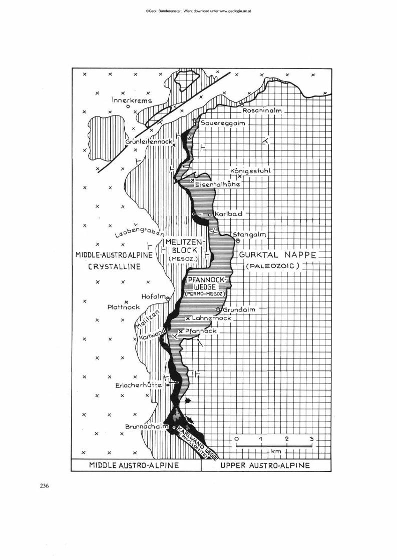
X X X j
I n n e r k r e m s >f 0 ^rrXffWQf
'Hl Grunleifennocl lr;J
X X i
x x x l l , \
X X v >
MIDDLE-AU5TR0ALPINE\i [ CRYSTALLINE ^J
Hofalnrus X x — r r f
P laHnock /fTTT
X x i S * S |
X X \
1 /l * x * 1 \
Erlach<zrhüH<z •
X x x | H x * * Jiji Brunnachaln^
x x U f
X X X \ \
MIDDLE AUSTRO-ALPir
/<1^|üJJf^_ \ X
u>̂ x ^-fpr
x rfTTU/T Rosa ni na L_
f f j j | Sauer izaaalm .
1— ]^^ET3
c K 3
B h
,rs=£| Jfe^ L ^L jEr*>< i " "^_ Eiscntc
Kon A
a lhöhe
^^==relKariPci<-J
i P^
X
igssTuhl
1 S+angalrn
Fl IT7PN - j " )• BLOCK 'JL j
.MESOZ.) | ^ (
\ wmESk { fPFANNOCK \ fcUEDGE / M(PERMO-MES 17 f ^ g
3
p i 1 1 I
m
GURKTAL NAPf
( P A L E O Z O I C ;
J t y p run d a im ^ ^ = x Lahnernock
p = x Pfannock " ^ ^ ^ ssT
B H
wV
B^IÄ*. S$s3l -nfcSSL 'tip
^i ?
. O 1 P •"> 1 1 1
- k m J i I
JE UPPER AUSTRO-ALPINE
©Geol. Bundesanstalt, Wien; download unter www.geologie.ac.at
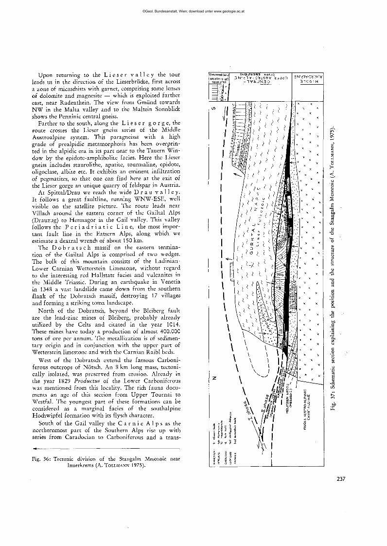
Upon returning to the L i e s e r v a l l e y the tour leads us in the direction of the Lieserbrücke, first across a zone of micaschists with garnet, comprising some lenses of dolomite and magnesite — which is exploited farther east, near Radenthein. The view from Gmünd towards NW in the Malta valley and to the Maltein Sonnblick shows the Penninic central gneiss.
Farther to the south, along the L i e s e r g o r g e, the route crosses the Lieser gneiss series of the Middle Austroalpine system. This paragneisss with a high grade of prealpidic metamorphosis has been overprinted in the alpidic era in its part near to the Tauern Window by the epidote-amphibolite facies. Here the Lieser gneiss includes staurolithe, apatite, tourmaline, epidote, oligoclase, albite etc. It exhibits an eminent infiltration of pegmatites, so that one can find here at the exit of the Lieser gorge an unique quarry of feldspar in Austria.
At Spittal/Drau we reach the wide D r a u v a l l e y . It follows a great faultline, running WNW-ESE, well visible on the satellite picture. The route leads near Villach around the eastern corner of the Gailtal Alps (Drauzug) to Hermagor in the Gail valley. This valley follows the P e r i a d r i a t i c L i n e , the most important fault line in the Eatsern Alps, along which we estimate a dextral wrench of about 150 km.
The D o b r a t s c h massif on the eastern termination of the Gailtal Alps is comprised of two wedges. The bulk of this mountain consists of the Ladinian-Lower Carnian Wetterstein Limestone, without regard to the interesting red Hallstatt facies and vulcanites in the Middle Triassic. During an earthquake in Venetia in 1348 a vast landslide came down from the southern flank of the Dobratsch massif, destroying 17 villages and forming a striking toma landscape.
North of the Dobratsch, beyond the Bleiberg fault are the lead-zinc mines of Bleiberg, probably already utilized by the Celts and citated in the year 1014. These mines have today a production of almost 400.000 tons of ore per annum. The metallization is of sedimentary origin and in conjunction with the upper part of Wetterstein limestone and with the Carnian Raibl beds.
West of the Dobratsch extend the famous Carboniferous outcrops of Nötsch. An 8 km long mass, technically isolated, was preserved from erosion. Already in the year 1829 Productus of the Lower Carboniferous was mentioned from this locality. The rich fauna documents an age of this section from Upper Tournai to Westfal. The youngest part of these formations can be considered as a marginal facies of the southalpine Hochwipfel formation with its flysch character.
South of the Gail valley the C a r n i c A l p s as the northernmost part of the Southern Alps rise up with series from Caradocian to Carboniferous and a trans-
Fig. 36: Tectonic division of the Stangalm Mesozoic near Innerkrems (A. TOLLMANN 1975).
©Geol. Bundesanstalt, Wien; download unter www.geologie.ac.at
gressive second stage from uppermost Carboniferous to Triassic.
Day 7
The Late Paleozoic of the Nassfeld Area in the Carnic Alps
(A. F E N N I N G E R ) *)
R o u t e : He rmagor — Nassfeld — Gugga, Flora, Garni tzenberg — H e r m a g o r — Gailberg pass — Lienz.
S u b j e c t : The Late Paleozoic of the Carnic Alps shows its widest extent in the area a round the Naßfe ld and the Straniger Aim. The Carboniferous up to West-falian B can not be studied wi thin the scope of the excursion and is therefore not t reated in this account.
O n the one hand the area a round the Naßfe ld is known by the development of the Auernig G r o u p containing the famous sections of Auernig, Garn i tzen and Krone , on the other h a n d by Permian sections as R e p p -w a n d , Tressdorferhöhe, Grenz l andkamm and Schulter.
R e f e r e n c e s
BUGGISCH, W., FLÜGEL, E., LEITZ, F. & TIETZ, G.-F. (1976):
Die fazielle und paläogeographische Entwicklung im Perm der Karnischen Alpen und in den Randgebieten. —• Geol. Rdsch., 65, 649—690, Stuttgart.
*) Doz. Dr. A. FENNINGER, Geologisch-Paläontologisches
Institut, Universität, Heinrichstraße 26, A-8010 Graz.
GAURI, K. (1965): Uralian Stratigraphy, Trilobites, and Brachiopods of the Western Carnic Alps (Austria). — Jb. Geol. B.-A., SB 11, 94 p., Wien.
GORTANI, M. (1924): Nouve ricerche geologiche nelle Alpi Carniche. — Boll. Soc. geol. ital., 43, 101—111, Roma.
HERITSCH, F., KAHLER, F. & METZ, K. (1934): Die Schicht
folge von Oberkarbon und Unterperm. — In: HERITSCH, F.: Die Stratigraphie von Oberkarbon und Perm in den Karnischen Alpen. — Mitt. geol. Ges. Wien, 26 (1933), 163—180, Wien.
KAHLER, F. (1974): Fusuliniden aus T'ien-schan und Tibet. Mit Gedanken zur Geschichte der Fusuliniden-Meere. — Rep. Sei. Exped. North-Western. Prov. China. Sven Hedin, Sino Swedish Expl., Publ., 52, V, X + 147 p., Invert. Paleont., 4, Stockholm.
KAHLER, F. & PREY, S. (1963): Erläuterungen zur Geologi
schen Karte des Naßfeld-Gartnerkofel-Gebietes in den Karnischen Alpen. — Geol. B.-A., 116 p., Wien.
SELLI, R. (1963): Schema geologica delle Alpi Carniche e Giulie Occidentali. — Giorn. Geol., 30, 1—136, Bologna.
WATERHOUSE, J. B.: World Correlations for Permian Marine Faunas. — Univ. Queensland Pap., Dept. Geol., 7, St. Lucia 1976.
I n t r o d u c t i o n
The A u e r n i g G r o u p transgresses over the Car boniferous flysch (Hochwipfel Format ion) and represents the final-stage of the Variscan geosyncline in the form of a cyclothemic Molasse. A t the Carboniferous/ Permian bounda ry this environment changes to an in-
Trogko fel
T*S«I
•??/.•'.
i§j?i
' A l luv ium
Triassic
Permian
Upper Carboniferous
Löwer Carboniferous-Si lur ian
Other Lower Falaeozoic
Gailtal „ Metamorphics
Foul t
Fig. 38: Sketch map of the Naßfeld Area in the Carnic Alps (F. KAHLER & S. PREY, 1963; after E. R. OXBURGH, 1968).
238
©Geol. Bundesanstalt, Wien; download unter www.geologie.ac.at
ner-shelf facies which gradually passes into a carbonate platform (Rattendorf Group, Trogkofel Limestone and Tressdorf Limestone). Synsedimentary tectonic activities at the Lower/Middle Permian boundary lead to a destruction of this carbonate platform. Conglomerates and breccias were deposited in local depessions (Tarvis Breccia). The A l p i d i c c y c l e starts in the Middle Permian with the clastic Gröden Formation which in the Carnic Alps is mainly developed in marine facies. The increasing transgression during the Upper Permian results in the deposition of the basal evaporitic Bellero-phon Formation (BUGGISCH et al. 1976) (Fig. 39).
The A u e r n i g G r o u p , up to 700 m in thickness, represents a sequence of shales, siltstones, sandstones, conglomerates, and different types of limestones and dolomites. Locally small coal seams are intercalated. The characteristic elements of fauna and flora are Dasycla-dacea, Rhodophycea, fusulinids, small foraminifers, Sphinctozoa, brachiopods, corals, conulates, lamelli-branchs, gastropods, bryozoans, trilobites, and echino-dermats. Elements of terrestrial flora are abundant in single layers, predominantly in finer-clastic rocks. In accordance to the frequency and thickness of carbonates the Auernig Group is divided into five formations (HERITSCH et al. 1934) (Fig. 40). SELLI 1963 registered these lithologic names and proposed formational designations based on local (topographic) names. The correlation is shown in the following table.
SELLI 1963
Formazione del Carnizza Formazione del Auernig Formazione del Corona Formazione del Pizzul Formazione di Meledis
HERITSCH et al. 1934
Upper kalkarme Formation Upper kalkreiche Formation Middle kalkarme Formation Lower kalkreiche Formation Lower kalkarme Formation
The Auernig Formations are partly retained as in German for the sake of brevity.
The Lower kalkarme Formation in the Naßfeld area is sparsely exposed. It is typically developed, however, in the area of the Straniger Alm (Waschbühel Section). There the Waidegger Fauna (GAURI 1965) has been famous for long times. The distinct development starts with the Lower kalkreiche Formation. The so called "Geröllschiefer", representing a contemporary development to the Lower kalkarme Formation and being deposited in depressions, are not exposed in the area of the Naßfeld. They transgressively overly the Variscan basement and are interpreted as continental debris flows and fluviatile sediments.
The Auernig Group may be subdivided into a series of cyclothems, the Lower kalkarme Formation representing a cyclothem with dominantly marine shales. The Lower kalkreiche as well as the Upper kalkreiche Formations are balanced cyclothems, whereas the Middle kalkarme Formation represents a cyclothem type with basal sandstones and conglomerates dominating. The Upper kalkarme Formation seems to claim a transitional
Paläo-fusulina
Codono-fusiella
Lepidolina •< Yabeina
Neo-schwagerina •
simplex
Cancellina
Misellina
Pseudo-fusulina vulgaris
Pseudo-schwagerina
Zellia
Pseudoschwagerina confinii
Pseudoschwagerina alpina
Bellerophon Formation
Gröden Formation
Tressdorf Lmst.
Trogkofel Limestone
Upper Pseudoschwagerina Lmst.
Grenzland Formation
Lower Pseudoschwagerina Lmst.
Fig. 39: Fusulinide stratigraphy of the Permian in the Naßfeld area, Carnic Alps (F. KAHLER, 1974, W. BUGGISCH et al.,
1976).
Pseudofusulina
r" Daixina
Rugosofusulina
Triticites
Protriticites
Upper kalkarme Fm.
Upper kalkreiche Fm.
Middle kalkarme Fm.
Lower kalkreiche Fm.
Fig. 40: Fusulinid stratigraphy of the Carboniferous Auernig Group (F. FRANCAVILLA & G. B. VAI, 1980).
position between balanced and shale-dominated cyclothems.
239
©Geol. Bundesanstalt, Wien; download unter www.geologie.ac.at
Concerning biostratigraphy some items are not quite clear:
1. The Cantabrian is not definitely distinguished; 2. The Carboniferous/Permian boundary is open to
question.
WATERHOUSE (1976) — referring to the worldwide correlation of brachiopod faunas — assigned parts to the Middle kalkarme Formation (?) and the upper Formations to the Asselian, putting them all into the Permian. Referring to fusulinid stratigraphy (KAHLER SC PREY 1963, KAHLER 1974, FRANCA VILLA & VAI in press)
the Carboniferous/Permian boundary is defined by the first appearance of Pseudoschwagerina alpina, and the first unit of Asselian thus in the Lower Pseudoschwagerina Limestone. The evolution of the flora corresponds with the fusulinid stratigraphy.
The excursion route is only crossing a part of the Garnitzen Section (Fig. 41), the Middle kalkarme Formation and the Upper kalkreiche Formation. Compared with other sections the great thickness of the Garnitzen Section is a remarkable phenomenon. It is caused by tectonic repetitions of the Middle kalkarme and the Upper kalkreiche Formation, which are clearly proved by mapping, fossil-bearing horizons and sedimentologi-cal parameters.
Stop 7.1. Road Junction Kötschach/Hermagor — Naßfeld
View of the Permian/Triassic section of the Repp-wand and the Gartnerkofel.
Stop 7.2. End of chair-lift at Pt. 1902 The limestones and marls, which belong to the up
per parts of the Lower kalkreiche Formation, can be devided into three horizons: a basal pebbly, sometimes dolomitic limestone, a middle layer consisting of marls, and an upper crinoidal breccia. The fauna was determined by WINKLER PRINS and comprises: Stropho-
menida indet., Proteguliferina ? sp., Chaoiella sp., Rhyn-chonellida indet., Stenoscisma sp., Zaissania ? cf. coronae (SCHELLW.), Martinia karawanica VOLGIN, "Martinia"
cf. carinthiaca SCHELLV., Duplophyllum sp., Amplexo-carinia smithi HERITSCH, Wilkingia} cf. elegantissima (STUCKENB.), Annuliconcha sp., Conocardium cf. urali-cum de VERNEUIL, Gastropoda, Colospongia sp. A
spinctozoan faunula was published by LOBITZER 1975: Sollasia ? sp., Girtyocoelia cf. beedei (GIRTY), Girtyo-coelia ? sp., Colospongia typica (KING), Colospongia sp., Colospongia ? sp., Amblysiphonella cf. barroisi STEINMANN, Amblysiphonella sp., Cystauletes ? sp.
-wsw ~ E N E ~NNW
FENNINGER FRANCAVILLA&VAI
~ N N E
Upper kalkreiche Fm
\ M i d d i e kalkarme Fm
Lower \ 1902
kalkreiche Fm.
1900
1800
1700
1600
1500-
1400
1300
1200
Tröpolach Gartnerkofe A
2195
AUSTRIA
Naßfei llGarnitzenBerg
n ip * *
Limestones
I.''.-;:-..'! Shales-Sandstones
Conglomerates
/ • v\." Bombaso t •.<.'•>
Bombaso\Hochwiptel
ITALY/ Auern|9 (b ) Stop
Pontebba
Fig. 41: The Garnitzen section in the Carnic Alps, simplified.
240
©Geol. Bundesanstalt, Wien; download unter www.geologie.ac.at
Shales with Isogramma paotechowensis CHAO: The limestones and marls mentioned above are overlain by partly carbonatic sandstones and mica-rich shales containing Isogramma paotechowensis. Beside Isogramma paotechowensis one can find: Orbicuolidea, Derby a sp., Linoproductus sp., Brachythyrina sp. Isogramma paotechowensis can be found in different places of the Naßfeld area and is thus useful for local correlation. In Eurasia this species ranges up to the Permian. GORTANI 1924 described Orthotethes expansus which seems to be a younger synonym of Isogramma paotechowensis.
First we cross the Middle kalkarme Formation one part of which' shows a tectonic repetition. The outcrops are sometimes rather sparse, especially along the path.
Stop 7.3. Gugga
Beginning with the Upper kalkreiche Formation the conditions of exposure are better. In this part the Gar-nitzen Section shows a tectonic repetition of the whole Upper kalkreiche Formation. The limestone horizon of Gugga gradually passes into marls rich in fusulinids (Quasifusulina tenuissima (SCHELLW.)) and contains a brachiopod-fauna with: Rhynchoporacea indet., Phri-codothyris sp., Strophomenida indet., Urushtenial. sp., Proteguliferina? sp., Kozlovskia sp., Karavankina cf. praepermica RAMOVS, Karavankina sp.
The overlying sandstones with brachiopods and conu-lariids are characterized by: Orthida indet., Linoproductus cf. cora (d'ORB.), Rhynchonellida indet., Phricodothyris} sp.
Stop 7.4. Pt. 1914
After a fault the section begins with pebbly sandstones and conglomerates and is overlain by a sandstone horizon passing into shales and siltstones with a rich flora of Middle and Upper Stefanian age: Pecopteris polymorpha, P. unita, P. hemitelioides, P. (?) obliquener-vis, Crossotheca sp., fructifications comparable Aci-theca, Odontopteris brardii, Alethopteris subelegans, Cordaites cf. borassifolius, Cordaites sp., Rhabdocarpus sp., ? Frigonocarpus sp., Annularia sphenophylloides, Sigillariophyllum sp.
Stop 7.5. Garnitzenberg Following the path to the Garnitzenberg we cross
algae-rich marls (mainly with Anthracoporella spectabilis and phylloid algae). Beside the algae one can find: Enteletes lamarckii (FISCHER V. WALDH.), Strophomenida indet., Urustenia sp., Proteguliferina ? sp., Avonia (Quasiavonia) cf. echinidiformis (CHAO), Avonia ? cf. curvirostris (SCHELI/W.), Kozlowskia sp., Alexnia cf. gratiodentalis (GRABAU), Cancrinella sp., Karavankina praepermica RAMOVS, Rhynchonellida indet., Stenoscis-ma cf. alpina (SCHELLW.), Cleiothyridina cf. pectinifera (Sow.), Brachythyrina cf. carnica (SCHELLW.), Neospiri-fer sp., Zaissania ? cf. coronae (SCHELLW.), „Martinia"
carinthiaca SCHELLW., Phricodothyris sp., Lophocarino-phyllum sp., Annuliconcha sp., Conocardium cf. urali-cum VERNEUIL, Trachydomia sp., Straparollus lutugini JAKOW.
After a fault the Upper kalkreiche Formation sets in again. Along the path once more above mentioned marls occur with: Heteralosia sp. ?, Urushtenia ? sp., Proteguliferina ? sp., Kozlowskia sp., Rhynchonellida indet., Cleiothyridina cf. pectinifera (Sow.), Neospiri-fer sp., Spiriferella ? sp., „Martinia" cf. carinthiaca SCHELLW., Phricodothyris ? sp., Conocardium uralicum VERNEUIL, Trachydomia sp., Microdoma sp.
Day 8
The Penninic System along the Großglockner Road
(W. FRANK) *)
R o u t e : Lienz — Heiligenblut — Großglockner Road — Zell am See.
R e f e r e n c e s : BRACK, W. (1977): Diss. Univ. München; CORNELIUS, H. P. & CLAR, E. (1939): Abh. Reichsst. f. Bo-denf. (Geol. B.-A.), 25, Wien; EXNER, Ch. (1964): Erl. Sonn-blickgruppe, Geol. B.-A., Wien; FRASL, G. (1958): Jb. Geol. B.-A., 101, Wien; FRASL, G. & FRANK, W. (1969): Wiss. AV-Hefte, 21, Innsbruck; HOCK, V. (1974): Karinthin, 71, Klagenfurt; Mitt. öst. geol. Ges., 72 (1980); HOCK, V. & HOSCHEK, G. (1980): Mitt. öst. geol. Ges., 72, Wien; HOCK, V. & MILLER, Ch. (1980): Mitt. öst. geol. Ges. 72, Wien; MILLER, Ch. (1977): Tsdiermaks miner, petrogr. Mitt., Wien.
G e o l o g i c m a p s : CORNELIUS, H. P. und CLAR, E. (1939): Geologisdie Karte des Großglocknergebietes, Geol. B.-A., Wien; EXNER, Ch. (1962): Geologisdie Karte des Sonnblickgebietes, Geol. B.-A., Wien; TH. OHNESORGE et al. (1935): Geologisdie Karte von Kitzbühel und Zell am See, 1 : 75.000, Geol. B.-A., Wien.
T o p o g r . m a p s : Alpen vereinskarte 1 :25.000, Bl. 40, Großglockner; österr. Karte 1 : 50.000, Bl. 153, 154.
Introduction Along the route a complete section through the Pen
ninic Tauern Window is studied. Coming from the south (Lienz) one has first to cross the Middle Austro-alpine Crystalline of the Schobergruppe. The internal pre-Alpine structures of this medium grade metamorphic Crystalline (paragneisses, micaschists, amphibolites, eclo-gites and orthogneisses of different origin, partly with proved Caledonian metamorphism) have been well preserved in general. But whereas Hercynian mineral ages are known from the southern and tectonically higher levels, a pronounced heating during the Cretaceous is proved in deeper levels (cf. BRACK 1978). This heating took place when the Austroalpine was still south of the
*) Doz. Dr. W. FRANK, Institut für Geologie, Universität, Universitätsstr. 7, A-1010 Wien.
16 Geol. Bundesamt., Abh., Bd. 34 241
©Geol. Bundesanstalt, Wien; download unter www.geologie.ac.at
Pennine and the metamorphism interfered with the consumption of the Penninic ocean. The existence of this paired metamorphic belt (high pressure, Pennine — intermediate pressure regime) was most probably terminated as a result of large scale overthrusting of the Austroalpine onto the Pennine in the Upper Cretaceous (80—76 my). In this section the same pre-Alpine Crystalline was only at its immediate base and much less affected by the Tertiary metamorphic and structural events, intensely developed in the underlying Penninic schists. At the northern side of the Tauern cupola the continuation of this Crystalline is missing and the window is separated by a steep mylonitic fault from the Upper Austroalpine Grauwackenzone.
T a u e r n W i n d o w : L i t h o s t r a t i g r a p h y a n d P a l e o g e o g r a p h y :
T h e p r e - M e s o z o i c s e q u e n c e s are developed in the lower tectonic units in the western and eastern part of the window. They comprise a strongly overprinted pre-Alpine polyphase metamorphic Crystalline which has partly a close relationship with the usual western Austroalpine Crystalline. Also few early Paleozoic orthogneisses are incorporated here. An early Paleozoic geosynclinal sequence with large volumes of mainly basic, but also intermediate and acid volcanic material is another important rock series. Paleozoic carbonates are essentially missing, some Paleozoic sequences with a pronounced sedimentary graded bedding (e. g. parts of the Greiner schists in the west) possibly represent Late Paleozoic flysch deposits. The typical Carboniferous Molasse type gravel sediments are missing. All these Paleozoic series are intruded by large Hercynian meta-granitoids and metatonalites. Partly they are associated with high grade Hercynian metamorphism and deformation. However, the magmatic activity continued until
LITHOSTRATIGRAPHIC SEQUENCE OF THE SEIDLWINKL-TRIASSIC W.R1964
C^300-400m)
KEUPER . - , - . . __ - ^_ - "0.uartcnschicfer" = f T-1~".'J'T ' ' . E ' ^ " V 5 liqhtcoloured chloritoidschists Aquartzites
grey dolomite
rquhiuacUes luith gypsum
caceous dolomites '^TJp^l'^l^Js a««»«" mi
ANISIAN ST—'
SKYTH^AN .
PERMIAN
^ banded dol ..alternating with wi th marble * ~ Lenses
r^_J_^- ' — - A ^ ^ rauhujacke horizon, marbles with phyll ite •r*v •, J*J" I M fcgsi components
platy,light greenquartzites
? * ^ \ phengitearcosic gneisses -schists,partly " y J W '^ quartzporphyry pebbles
Fig. 42: The sequence of the Seidlwinkl Triassic in the area of the Glockner road.
the Upper Permian. From this respect, the basement in the Tauern Window can be regarded as one of the youngest tectonically active zones in the Varican orogen.
These pre-Mesozoic rock series are only developed west and east of the excursion route, which entirely lies in the N—S striking Großglockner axial depression zone of Permomesozoic sediments.
P e r m o s c y t i a n : East of the Hochtor on top of the Großglockner road is the type locality of the Permo-scythian Wustkogelserie (FRASL 1958). The lower member consists of arcosic gneisses with boulders of the older basement and from acid volcanics. A high amount of the clastic material was derived from acid volcanics respectively shallow granitic intrusions. The higher member (probably mostly Scythian) is a uniform quart-zite horizon. Fig. 42 shows also the Middle Triassic carbonate rocks of the S e i d l w i n k l t r i a s , which exhibits the typical Germanic Keuper facies. The Seidlwinkltrias is stratigraphically overlain by the so-called B r e n n k o g e l S e r i e s , one of the different evolutions of Bündnerschiefer. The Brennkogel Series is characterized by a alternation of black phyllites and different quartzites with several horizons of reworked Triassic carbonates; also few prasinites are incorporated.
This Triassic — Jurassic sequence of the later Seidl-winklnappe was deposited south of the gneiss cores exposed today. The rifting, which led to the opening of the Penninic ocean started in the Liassic and caused a marked change in sedimentation and a pronounced facies variation. South of the Brennkogel Bündnerschiefer with their clastic terregeneous influence the main mass of B ü n d n e r s c h i e f e r of the Glockner-nappe developed. They are composed of a several km thick sequence of marls alternating with some pelites and large masses of basaltes (mainly tuffs, some pillow lavas . . .) deposited mostly on oceanic crust (e. g. the Heiligenblut serpentinites). The stratigraphy is uncertain, generally it is assumed that Upper Jurassic to Lower Cretaceous rocks are exposed in the Glockner region. Still further in the south the so-called F u s c h e r f a c i e s of Bündnerschiefer developed, characterized again by a distinct terregeneous influence: mainly pelites and some flysch type sediments derived from a metamorphic crystalline basement covered by Triassic carbonates. They obviously developed along the southern margin of the Penninic ocean close to the well known breccias of the Lower Austroalpine.
Detailed geochemical investigations (HOCK & MILLER 1980) have shown that the ophiolites of the Glockner facies resemble closely to midocean ridge basaltes, whereas the variable basic intrusions and volcanics in the Fuscher facies show close affinities to withinplate basaltes.
On the northern margin of the Penninic ocean two more post-Triassic sequences are developed in the western Hohe Tauern on the Hercynian basement which
242
©Geol. Bundesanstalt, Wien; download unter www.geologie.ac.at
corresponds to the Brianconnais of the Western Alps. They are the H o c h s t e g e n s e r i e s , an Upper Jurassic — Lower Cretaceous carbonate zone transgressing on the basement and the Lower Cretaceous Kaserer series (FRISCH, 1980) with partly very coarse clastic influence from the underlying basement. They are not exposed in the Glockner area. But it is assumed that a uniform pelitic sequence south of Fusch represents the post-Triassic cover north of the Brennkogelschists.
T e c t o n i c a n d s t r u c t u r e s :
The N—S sections in the Glöckner region (Fig. 43) clearly show the north-vergent transport in the Schieferhülle. The main feature is the giant recumbent fold of Glockner- and Seidlwinklnappe which developed at the base of the Glocknernappe after the Seidlwinklnappe was overridden. Although the southern part and especially the inverted limb is extremely thinned, the core and both limbs of the fold can be traced more than 25 km to the SE.
The base of the Glocknernappe can be regarded as a tectonic melange horizon with lenses of serpentinites and Triassic rocks. Overlying the giant arch of the Glocknernappe s. str. we find a tectonically higher complicated wedge system: the thick Fuscher Schieferhülle, which forms a part of the Glocknernappe system in the north. In the south the highly tectonized Matreier Zone corresponds at least partly with this unit.
The three-dimensional structure of the whole system is very complicated. The northwestern end of the large-scale recumbent fold is overprinted by a pronounced N-S fold zone which caused also the N-S trending axial Glockner-depression. These N-S striking fold axes, mineral lineations and elongations exhibit a very distinct preferred N-S-orientation in the middle part and opens to fan structures in the north and in the south, where the neighbouring gneiss cores have no more influence. The author thinks that this "cross folding" developed contineously over a considerable time span (some 10 my). The first event probably was a elongation by simple shear in connection with subduction and formation of eclogites. Later then, when the oceanic sediments were thrust on the sialic basement, the elongation of this basement in the E-W direction caused the intense N-S folding in the inner part of the Glockner axial depression (fig. 44). We recognize also a remarkable Stockwerkstektonik as the N-S structures are developed from the southern margin of the window only to the northern border of the Glocknernappe s. str. The overlying Fuscher Schieferhülle show no relics of these N-S lineations, only E-W striking, gently west-dipping structures, which overprinted the whole outer part of the internal cupola.
A l p i n e m e t a m o r p h i s m :
Two main metamorphic events can be distinguished. The relatively older h i g h p r e s s u r e e v e n t is preserved as relics of eclogites and glaucophaneschists
(e. g. Gamsgrube NW Franz-Josefs-Höhe) at or near the southern base of the Glocknernappe and as form relics of lawsonite, widespread in higher horizons of the same unit (HOCK 1976). MILLER 1977 was able to distinguish five stages in the evolution of the eclogites to the prasinite mineral assemblages in the southern Venediger area which are also valid in the Glöckner region. The formation of the high pressure event at 8—10 kb and up to 500° C is correlated with subduction during the closure of the Penninic ocean. Due to widespread Ar40 overpressure no really conclusive radiometric data exist about the time of formation of the HP-event. In analogy to the results of HUNZIKER in the Western Alps and from the existing data a Cretaceous age is assumed.
The present mineral assemblages show the metamorphic zonation of the Early Tertiary T a u e r n k r i s -t a 11 i s a t i o n. In the outermost parts of the Schieferhülle this metamorphism had its thermal peak around 30—40 my, whereas biotit cooling ages in the neighbourhood cluster around 20—17 my. In general the Tertiary metamorphism show a concentric pattern (HOCK 1980) with low grade stages in the outermost horizons of the Schieferhülle (stilpnomelane NE Fusch) and highest grade greenschist facies in the central part. Only east of the Großglocknerroad a single occurrence of staurolite was reported (EXNER 1964). The characteristic white mica is phengite, biotite is usually absent or rare in metasedimentary rocks due to chemical reasons. Useful isogrades are the albite/oligoclase boundary in prasinites and the incoming of garnet and margarite in calcareous metasediments which' have been studied by HOCK & HOSCHEK 1980. Tremolite is common in the Triassic dolomites. From this mineral distribution metamorphic conditions of 500° C and approximately 5 kb can be deduced in the central part of the section especially in the Hochtor area.
In the whole central part of the Tauern Window the crystallisation postdated the deformation, whereas in the outer parts, especially in the north crystallisation and deformation took place simultaneously.
Stop 8.1. Kasereck, north of Heiligenblut Antigorite-serpentinite and ophicalcite together with
calcmicaschists at the base of the Glöckner nappe. View on the geology of upper Moll valley.
Stop 8.2. Franz-Josefs-Höhe Foot walk to Gamsgrube. Prasinites; highest meta
morphic Bündnerschist of Glöckner nappe with grossu-lar, margarite, eclogites and glaucophaneschists and their retrograde equivalents in the Gamsgrube.
243
©Geol. Bundesanstalt, Wien; download unter www.geologie.ac.at
SECTIONS THROUGH THE MIDDLE PART OF THE TAUERN UJINDOLU GEOLOGY SHOWN AS SEEN ON THE FLANKS OF THE VALLEYS UJ. FRANK,C5
Sonnbl ick gneiss core SEIDLLJINKL NAPPE £
rv*"-£"] central gneisses
arnphibolite scries
,^2*v series of the "old gneisses"
pre-Alpine Crystalline
|^VV;:vj Habach series (Ordouician-Silurian?)
:;| wustkogel series (Permo-Scythian)
Triassic
technically higher wedges of the Glöckner nappe
Brennkogel series mainly phyllites and quarizi + es
Parautochthonous phyllite series
\^>C^I Glockner series \ W \ \ 1
o c n tn
o > 3 r-« T.
Z fn
mainly calcareous mica schists and ophiolites scher series mainly phylliteSjCalcareous micaschists andophioliles
Fuscher series
Fig. 43
©Geol. Bundesanstalt, Wien; download unter www.geologie.ac.at
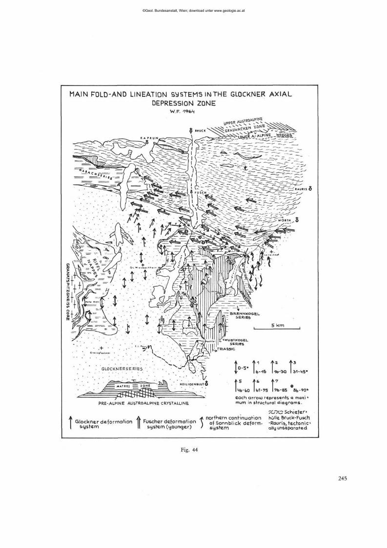
MAIN RDLD-AND LINEATION SYSTEMS INTHE GLOCKNER AXIAL DEPRESSION ZONE
W.F. 19fcM
$ ^ U W 6 1 A ? _ A L ? l N E _ _ W g D G E s :
"^KAURIS 5
PRE-ALPINE AUSTROALPINE CRYSTALLINE
to.5.r r t3
4- lfe-15 1-lb-T.Q I J1-M5*
p r r . Kb-faO Ib1-7S 176-85 8b-each arrou) represents a maxi • mum in structural diagrams.
A A _ .* northern continuation holla Bruck-Fus Glöckner deformation [ Fuscherdeformation \ of Sonnblick deform- -Raoris.tecron
s-ystem II system (younger) / system ally unseparate,
Fig. 44
©Geol. Bundesanstalt, Wien; download unter www.geologie.ac.at
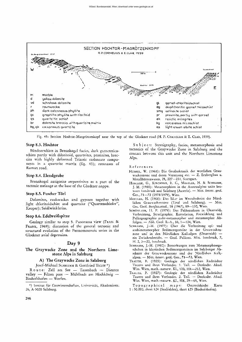
5ECT10N HOCHTOR-MAGROTZENKOPF H. P.CORNELIUS & E.CLAR -1939
marble
d yellow dolomite
vd schistose dolomite
r rauhujacke
ph dark ca lcareous phyl l i te
gc g raph i t i c phy l l i te u j i th clori toid
qs qua r t z i t i c schist
br dolomite b r e c c i a u i i th qua r t z i t e matr ix
kg ,qk ca lcareous qua r t z i t e
g l garnet-chlor i toidschist
dg d iaphthor i t ic garnet mfcaschi'st
smg actinolite. schist
pr p ras in i te ,par t ly w i th ga rne t
ek ra l ic t ic ec log i t es
kg calcareous mfcaschist
as l ight g reen a lb i te schist
Fig. 45: Section Hochtor-Margrötzenkopf near the top of the Glockner road (H. P. CORNELIUS & E. CLAR, 1939).
Stop 8.3. Hochtor Biindnerschists in Brennkogel facies, dark garnetmica-
schists pa r t l y wi th chloritoid, quartzites, prasinites, breccias wi th highly deformed Triassic carbonate components in a quar tz i te mat r ix (fig. 45) ; remnants of R o m a n road.
S t o p 8 .4 . E l e n d g r u b e
Brennkogel ant igori te serpentinites as a pa r t of the tectonic melange at the base of the Glockner nappe .
S t o p 8 .5 . Fuscher T o r i
Dolomites, rauhwackes and gypsum together wi th light chloritoidschist and quar tz i te ("Quartenschiefer", Keuper ) ; Seidlwinkltr ias .
S t o p 8.6. E d e l w e i ß s p i t z e
Geology similar to stop 5. Pano rama view (FRASL & F R A N K , 1969); discussion of the general tectonic and structural evolution of the Permomesozoic series in the Glockner axial depression.
Day 9 The Graywacke Zone and the Northern Lime
stone Alps in Salzburg
A) The Graywacke Zone in Salzburg Josef-Michael SCHRAMM & Gottfr ied T I C H Y *)
R o u t e : Zell am See — Taxenbach — Dienten valley — Filzen pass — Mühlbach am Hochkönig — Bischofshofen — Werfen.
*) Institut für Geowissenschaften, Universität, Akademiestr. 26, A-5020 Salzburg.
S u b j e c t : S t ra t igraphy, facies, metamorphosis and tectonics of the Graywacke Zone in Salzburg and the contact between this unit and the N o r t h e r n Limestone Alps.
R e f e r e n c e s HEISSEL, W. (1968): Die Großtektonik der westlichen Grau
wackenzone und deren Vererzung etc. — Z. Erzbergbau u. Metallhüttenwesen, 21, 227—231, Stuttgart.
HOSCHEK, G., KIRCHNER, E. C , MOSTLER, H. & SCHRAMM,
J.-M. (1980): Metamorphism in the Austroalpine units between Innsbruck and Salzburg (Austria). — Mitt, österr. geol. Ges., 71—72 (1978/1979), Wien.
MOSTLER, H. (1968): Das Silur im Westabschnitt der Nördlichen Grauwackenzone (Tirol und Salzburg). — Mitt. Ges. Geol. Bergbaustud., 18 (1967), 89—150, Wien.
SCHÖNLAUB, H. P. (1979): Das Paläozoikum in Österreich. Verbreitung, Stratigraphie, Korrelation, Entwicklung und Paläogeographie nicht-metamorpher und metamorpher Abfolgen. — Abh. Geol. B.-A., 33, 1—124, Wien.
SCHRAMM, J.-M. (1977): Über die Verbreitung epi- und anchimetamorpher Sedimentgesteine in der Grauwackenzone und in den Nördlichen Kalkalpen (Österreich) — ein Zwischenbericht. — Geol. Paläont. Mitt. Innsbruck, 7, H. 2, 3—20, Innsbruck.
SCHRAMM, J.-M. (1980): Bemerkungen zum Metamorphosegeschehen in klastischen Sedimentgesteinen im Salzburger Abschnitt der Grauwackenzone und der Nördlichen Kalkalpen. — Mitt. österr. geol. Ges., 71—72, Wien.
TRAUTH, F. (1925): Geologie der nördlichen Radstädter Tauern und ihres Vorlandes. 1. Teil. — Denkschr. Akad. Wiss. Wien, math.-naturw. KL, 100, 101—212, Wien.
TRAUTH, F. (1927): Geologie der nördlichen Radstädter Tauern und ihres Vorlandes. 2. Teil. — Denkschr. Akad. Wiss. Wien, math.-naturw. KL, 101, 29—65, Wien. T o p o g r a p h i c a l m a p s : österreichische Karte
1 : 50.000, sheet 124 (Saalfelden), sheet 125 (Bischofshofen).
246
©Geol. Bundesanstalt, Wien; download unter www.geologie.ac.at
Introduction The Graywacke Zone (part of the Upper Austro-
alpine Unit) is completely detached from its original crystalline basement and thrust over deeper Austroalpine units and the Penninic belt to the north. Therefore, deeper tectonic units border the Graywacke Zone on its southern side, whereas in the north rocks of the overlying Northern Limestone Alps are adjacent (see tectonic sketchmap, fig. 46). Compared with the Graywacke Zone in Tyrol and Styria the western part is simpler tectonically, has a more monotonous lithology and has fewer fossils. Stratigraphic details concerning the excursion route may be understood from figure 47. The stratigraphy is based mainly on conodonts and lithologic correlation. The base of the Northern Limestone Alps was affected by Alpine metamorphic events, and the Graywacke Zone additionally by Variscan meta-morphism. Due to equal intensities of metamorphism the Alpine stage cannot be distinguished from the older ones. Metamorphic minerals such as chloritoid, para-gonite and pyrophyllite, and illite crystallinity values below 4.0 (index sensu KUBLER) indicate low to very low grade metamorphism. The intensity decreases northwards. Thus, very low grade alterated Werfen beds can be detected as far as twenty kilometers north of the border between Graywacke Zone and Northern Limestone Alps (illite crystallinity values between 7.5 and 4.0).
The area visited is an old mining region. Iron ores have been exploited near Dienten and Werfen, crystalline magnesite in the areas of Goldegg, Dienten, and Hintertal, and copper ore at Mühlbach am Hochkönig. All mines are abandoned now.
Stop 9.1. Road cut in the southern part of the Dienten valley
Driving eastward through the Salzach valley we pass the narrow portion of Taxenbach and the slide area of Embach and reach the confluence with the Dienten Bach. The E-W running Salzach Valley Fault which determines the course of the Salzach valley, separates the Penninic Schieferhülle (S) from the Graywacke Zone (N). The fault was active at least up to Miocene and is manifested as a more or less wide zone. Therefore, the rocks of the southernmost part of the Graywacke Zone were strongly strained again after their tectonism during Variscan and Alpine orogenesis.
The cross section shows a typical sequence of Lower Wildschönau schists (Ordovician). Grey coloured phyl-lites and sericitic quartzites pass into calc-phyllites and also greenschists. The latter rocks represent syngenetic intercalations of formerly fine-grained diabases, fine layered diabasic tuffs and tuffites. Blastoids of stilp-nomelane (near Ferolisäge; visible only in thin section) and green biotite (S of Mühlwirt) in those rocks indicate greenschist facies. This corresponds with data from
the metasediments. The intensity of metamorphism is similar to that of the Bünden schists of the Penninic Tauern window. Minute folding, mainly steeply northward dipping s-surfaces, and gently WNW plunging B-axes determine the tectonic feature (figure 48). The course of the Dienten valley follows a NNW-SSE running system of Alpine faults.
R e f e r e n c e s BAUER, F. K., LOACKER, H. & MOSTLER, H. (1969): Geo-
logisch-tektonische Übersicht des Unterpinzgaues, Salzburg. — Veröff. Univ. Innsbruck, 13, Alpenkdl. Stud. VI, 1—30, Innsbruck.
EXNER, C. (1979): Geologie des Salzachtales zwischen Taxenbach und Lend. — Jb. Geol. B.-A., 122, 1—73, Wien.
FRASL, G., HOCK, V., KIRCHNER, E., SCHRAMM, J.-M. & VETTERS, W. (1975): Metamorphose von der Basis der Nördlichen Kalkalpen bis in die tiefsten Einheiten der Ostalpen im Profil Salzburg — mittlere Hohe Taueren. — Geol. Tiefbau Ostalpen, 2, 6—8, Wien (Zentralanst. Met.) 1974.
Stop 9.2. Road cut N of inn "Ronachbäck" We drive northward to Ronachbäck, where a series
of lenticular crystalline magnesite bodies cross the Dienten valley. The banded grey magnesite and the adjacent dark phyllites strike WNW and the s-surfaces dip steeply northward. Probably the magnesites are of Upper Silurian (Ludlovian-Pfidolian) age. However, their stratigraphical position could not be determined in detail. Fine-grained layers change to coarsely-crystalline pinolite (at the northern part of the outcrop). Based on investigations of the structure HADITSCH supposed a postdiagenetic and metasomatic origin of the magnesite. A system of fissures (partly infilled with younger dolomite, and quartz) dissects the magnesite body.
R e f e r e n c e s HADITSCH, J. G. (1969): Beiträge über das Gefüge von Spat
lagerstätten. Untersuchungen an Bändermagnesiten von Asturreta (Spanien) und Dienten (Salzburg). — Radex-Rdsch., 1969, 426—438, Radenthein.
MOSTLER, H. (1973): Alter und Genese ostalpiner Spatmagnesite unter besonderer Berücksichtigung der Magnesitlagerstätten im Westabschnitt der Nördlichen Grauwackenzone (Tirol, Salzburg). — Veröff. Univ. Innsbruck, 86, 237—266, Innsbruck.
REDLICH, K. A. (1935): Über einige wenig bekannte kristalline Magnesitlagerstätten Österreichs. — Jb. Geol. B.-A., 85, 101—133, Wien.
Stop 9.3. Road cut at the western ascent to the Filzensattel
Continuing the excursion we pass the village Dienten, whose church hill is underlain by Dienten schists (Silurian). North of Dienten we enter the Northern Limestone Alps.
247
©Geol. Bundesanstalt, Wien; download unter www.geologie.ac.at
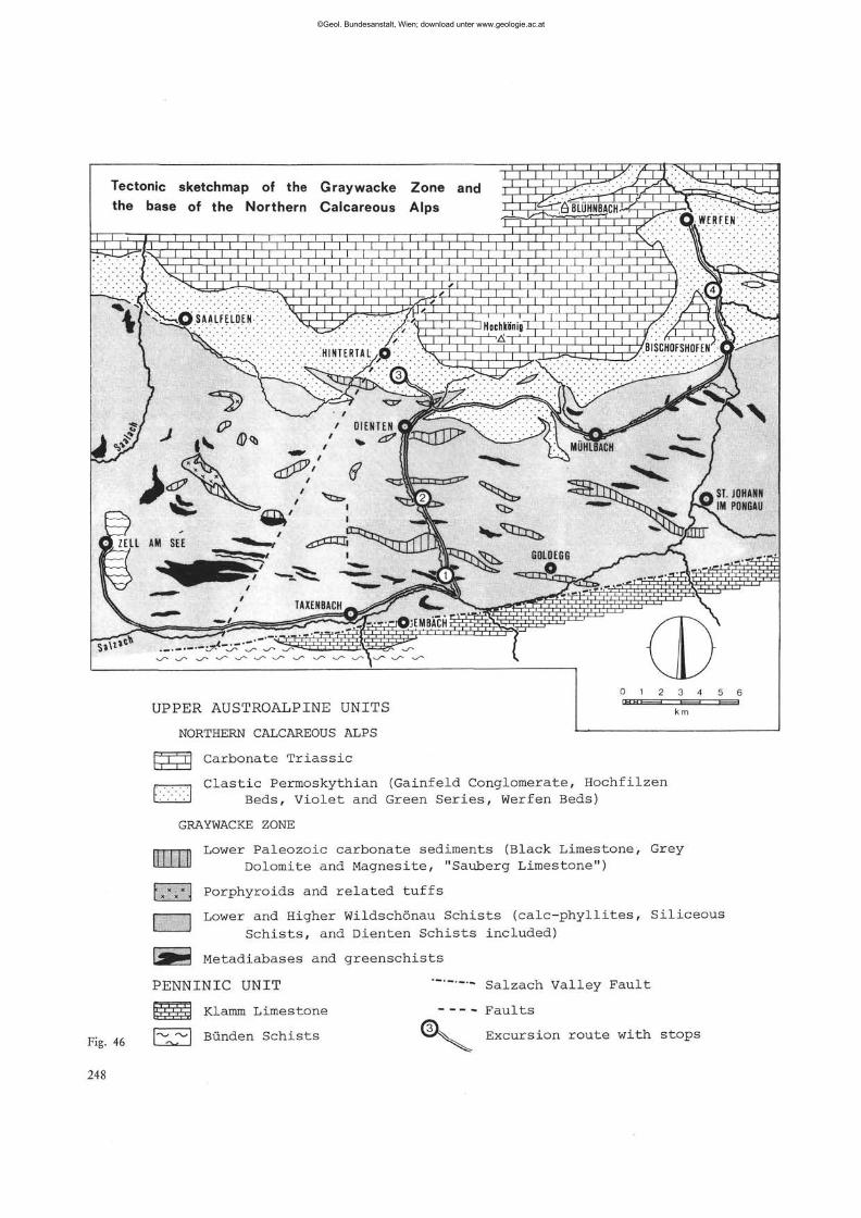
UPPER AUSTROALPINE UNITS
NORTHERN CALCAREOUS ALPS
Carbonate Tr i a s s i c TZL
Clastic Permoskythian (Gainfeld Conglomerate, Hochfilzen Beds, Violet and Green Series, Werfen Beds)
GRAYWACKE ZONE
Effl] *x*J Porphyroids and related tuffs
Lower Paleozoic carbonate sediments (Black Limestone, Grey Dolomite and Magnesite, "Sauberg Limestone")
I 1 Lower and Higher Wildschönau Schists (calc-phyllites, Siliceous Schists, and Dienten Schists included)
Fig. 46
248
üSBü3 Metadiabases and greenschis t s
PENNINIC UNIT
Klamm Limestone
Bünden Schists
Salzach Valley Fault
Faults
>-^. Excursion route with stops
©Geol. Bundesanstalt, Wien; download unter www.geologie.ac.at
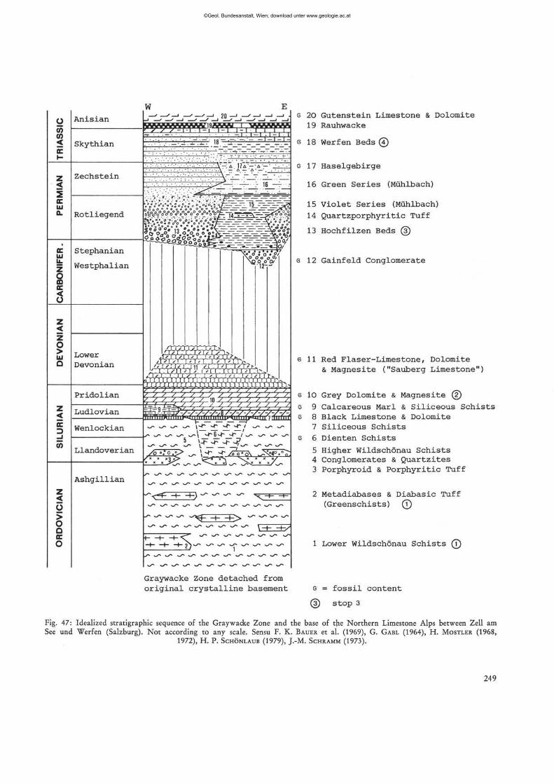
z < E D _J CO
> O Q
o
Pridolian
Ludlovian
Wenlockian
Llandoverian
Ashgillian
y^U i <,&&&& •tiinimr
\-f* *r - t* •*• i • •^r- ^ »\ ^6*4"* *̂ ~ / *s* **r* v̂ ^
,-c* - r -r *y*s* _<- ^~ ^r 5 \_i~ .
-<**• ± s>
"*9- H- -K>
5. Graywacke Zone detached from original crystalline basement
6 20 Gutenstein Limestone & Dolomite 19 Rauhwacke
s 18 Werfen Beds 0
G 17 Haselgebirge
16 Green Series (Mühlbach)
15 Violet Series (Mühlbach)
14 Quartzporphyritic Tuff
13 Hochfilzen Beds (3)
s 12 Gainfeld Conglomerate
6 11 Red Flaser-Limestone, Dolomite & Magnesite ("Sauberg Limestone")
s 10 Grey Dolomite & Magnesite ©
Siliceous Schists Calcareous Marl Black Limestone & Dolomite Siliceous Schists Dienten Schists
Higher Wildschönau Schists Conglomerates & Quartzites Porphyroid & Porphyritic Tuff
2 Metadiabases & Diabasic Tuff (Greenschists) (T)
1 Lower Wildschönau Schists (?)
G = fossil content
(D Stop 3
Fig. 47: Idealized stratigraphic sequence of the Graywacke Zone and the base of the Northern Limestone Alps between Zell am See und Werfen (Salzburg). Not according to any scale. Sensu F. K. BAUER et al. (1969), G. GABL (1964), H. MOSTLER (1968,
1972), H. P. SCHÖNLAUB (1979), J.-M. SCHRAMM (1973).
249
©Geol. Bundesanstalt, Wien; download unter www.geologie.ac.at
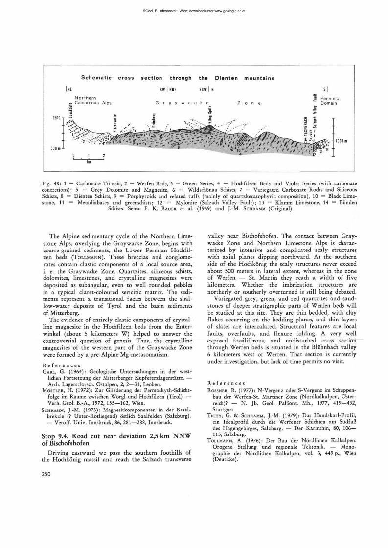
Fig. 48:1 = Carbonate Triassic, 2 = Werfen Beds, 3 = Green Series, 4 = Hochfilzen Beds and Violet Series (with carbonate concretions); 5 = Grey Dolomite and Magnesite, 6 = Wildschönau Schists, 7 = Variegated Carbonate Rocks and Siliceous Schists, 8 = Dienten Schists, 9 = Porphyroids and related tuffs (mainly of quartzkeratophyric composition), 10 = Black Limestone, 11 = Metadiabases and greenschists; 12 = Mylonite (Salzach Valley Fault); 13 = Klamm Limestone, 14 = Bünden
Schists. Sensu F. K. BAUER et al. (1969) and J.-M. SCHRAMM (Original).
valley near Bischofshofen. The contact between Graywacke Zone and Northern Limestone Alps is characterized by intensive and complicated scaly structures with axial planes dipping northward. At the southern side of the Hochkönig the scaly structures never exceed about 500 meters in lateral extent, whereas in the zone of Werfen — St. Martin they reach a width of five kilometers. Whether the imbrication structures are northerly or southerly overturned is still being debated.
Variegated grey, green, and red quartzites and sandstones of deeper stratigraphic parts of Werfen beds will be studied at this site. They are thin-bedded, with clay flakes occurring on the bedding planes, and thin layers of slates are intercalated. Structural features are local faults, overfaults, and flexure folding. A very well exposed fossiliferous, and undisturbed cross section through Werfen beds is situated in the Bliihnbach valley 6 kilometers west of Werfen. That section is currently under investigation, but lack of time permits no visit.
R e f e r e n c e s ROSSNER, R. (1977): N-Vergenz oder S-Vergenz im Schuppen
bau der Werfen-St. Martiner Zone (Nordkalkalpen, Österreich)? — N. Jb. Geol. Paläont. Mh., 1977, 419—432, Stuttgart.
TICHY, G. & SCHRAMM, J.-M. (1979): Das Hundskarl-Profil, ein Idealprofil durch die Werfener Schichten am Südfuß des Hagengebirges, Salzburg. — Der Karinthin, 80, 106— 115, Salzburg.
TOLLMANN, A. (1976): Der Bau der Nördlichen Kalkalpen. Orogene Stellung und regionale Tektonik. — Monographie der Nördlichen Kalkalpen, vol. 3, 449 p., Wien (Deuticke).
The Alpine sedimentary cycle of the Northern Limestone Alps, overlying the Graywacke Zone, begins with coarse-grained sediments, the Lower Permian Hochfil-zen beds (TOLLMANN). These breccias and conglomerates contain clastic components of a local source area, i. e. the Graywacke Zone. Quartzites, siliceous schists, dolomites, limestones, and crystalline magnesites were deposited as subangular, even to well rounded pebbles in a typical claret-coloured sericitic matrix. The sediments represent a transitional facies between the shallow-water deposits of Tyrol and the basin sediments of Mitterberg.
The evidence of entirely clastic components of crystalline magnesite in the Hochfilzen beds from the Enterwinkel (about 5 kilometers W) helped to answer the controversial question of genesis. Thus, the crystalline magnesites of the western part of the Graywacke Zone were formed by a pre-Alpine Mg-metasomatism.
R e f e r e n c e s GABL, G. (1964): Geologische Untersuchungen in der west
lichen Fortsetzung der Mitterberger Kupfererzlagerstätte. — Arch. Lagerstforsch. Ostalpen, 2, 2—31, Leoben.
MOSTLER, H. (1972): Zur Gliederung der Permoskyth-Schicht-folge im Räume zwischen Wörgl und Hochfilzen (Tirol). — Verh. Geol. B.-A., 1972, 155—162, Wien.
SCHRAMM, J.-M. (1973): Magnesitkomponenten in der Basal-brekzie (? Unter-Rotliegend) östlich Saalfelden (Salzburg). — Veröff. Univ. Innsbruck, 86, 281—288, Innsbruck.
Stop 9.4. Road cut near deviation 2,5 km NNW of Bischofshofen
Driving eastward we pass the southern foothills of the Hochkönig massif and reach the Salzach transverse
250
©Geol. Bundesanstalt, Wien; download unter www.geologie.ac.at
B) The Northern Limestone Alps in Salzburg B. PLÖCHINGER *)
R o u t e : Werfen — Golling — Hallein — Gartenau/ St. Leonhard — Adnet — Salzburg.
S u b j e c t : Stratigraphy and tectonics of the Northern Limestone Alps, Malmian-Lower Cretaceous series, intra-Malmian gliding of a Hallstatt outlier, Liassic Adnet Limestone.
R e f e r e n c e s : AMPFERER, O. (1936): Die geologische Bedeutung der Halleiner Tiefbohrung. — Jb. Geol. B.-A., 86, Wien; DEL NEGRO, W. (1970): Salzburg. — Verh. Geol. B.-A., Bundesländerserie, Heft Salzburg, 2. Aufl., 102 p., Wien; FAUPL, P. & TOLLMANN, A. (1979): Die Roßfeldschichten: Ein Beispiel für Sedimentation im Bereich einer tekto-nisch aktiven Tiefseerinne aus der kalkalpinen Unterkreide. — Geol. Rdsch., 68, H. 1, Stuttgart; HUDSON, J. D. & JENKYNS, H. C. (1969): Conglomerats in the Adnet Limestones of Adnet (Austria) and the origin of the "Scheck". — N. Jb. Geol. Pal. Mh., 1969, Stuttgart; HÄUSLER, H. (1979): Zur Geologie und Tektonik der Hallstätter Zone im Bereich des Lammertales zwischen Golling und Abtenau (Sbg.). — Jb. Geol. B.-A., 122, H. 1, Wien; MEDWENITSCH, W. (1963): Zur Geologie des Halleiner Salzberges (Dürrnberg). — Exk. führer 8. Europ. Mikropal. Koll. österr., Wien; PETRASCHECK, W. E. (1947): Der tektonische Bau des Hallein-Dürrnberger Salzberges. — Jb. Geol. B.-A., 90 (1945), Wien; PLÖCHINGER, B. (1955): Zur Geologie des Kalkalpenabschnittes vom Torrener Joch zum Ostfuß des Untersberges. — Jb. Geol. B.-A., 98, Wien; PLÖCHINGER, B. (1974): Gravitativ transportiertes permisches Haselgebirge in den Oberalmer Schichten (Tithonium, Salzburg). — Verh. Geol. B.-A., Wien; PLÖCHINGER, B. (1976): Die Oberalmer Schichten und die Platznahme der Hallstätter Masse in der Zone Hallein—Berchtesgaden. — N. Jb. Geol. Pal. Abh., 151, Stuttgart; PLÖCHINGER, B. (1977): Die Untersuchungsbohrung Gutrathsberg B I südlich St. Leonhard im Salzachtal (Salzburg). — Verh. Geol. B.-A., H. 2, Wien; PLÖCHINGER, B. (1977): Argumente für die intramalmische Ein-gleitung von Hallstätter Schollen bei Golling (Salzburg). — Verh. Geol. B.-A., H. 2, Wien; SCHLAGER, W. & SCHLAGER, M. (1973): Clastic sediments associated with radiolarites (Tauglboden-Schichten, Upper Jurassic, Eastern Alps). — Sedimentology, 20, Amsterdam; TOLLMANN, A. (1973): Grundzüge der alpinen Deckentektonik. — Wien (Deuticke), 404 p.; TOLLMANN, A. (1976): Analyse des klassischen nordalpinen Mesozoikums. — Wien (Deuticke), 580 p.; TOLLMANN, A. (1976): Der Bau der Nördlichen Kalkalpen. — Wien (Deuticke), p. 449, ZANKL, H. (1962): Die Geologie der Torrener Joch-Zone in den Berchtesgadener Alpen. — Z. dt. geol. Ges., 113, Hannover.
Geological maps: Hallein—Berchtesgaden (A. BITTNER, E. FUGGER) 1 : 75.000, Geol. R.-A. Wien, 1906; Adnet und Umgebung (M. SCHLAGER) 1 :10.000, Geol. B.-A. Wien, 1960; Umgebung der Stadt Salzburg (S. PREY) 1 :50.000, Geol. B.-A. Wien, 1969.
Topographie maps: österr. Karte 1 : 50.000, sheet 94 (Hallein), 125 (Bischofshofen).
*) Dr. B. PLÖCHINGER, Geologische Bundesanstalt, Rasu-mofskygasse 23, A-1031 Wien.
Introduction The miogeosynclinal marine series of the Northern
Limestone Alps were deposited during the general subsidence of the shelf environment in the Upper Austroalpine sedimentation area. Upon the evaporitebearing Permian sediments Triassic sediments in different facies are developed. According to their position there are mainly sediments of the lagoonal, reef or open sea environment. The sedimentation area of the Jurassic is characterized by the existence of more accentuated and differentiated longitudinal depressions and elevations. From the Jurassic up to the Middle Cretaceous important olistolithic glidings occurred. During the Intra-Cretaceous orogeny the sediments of the Northern Limestone Alps together with their normal Paleozoic base — the Grauwackenzone — were detached from the basement and moved towards north over the Lower Austroalpine and Penninic Zones. At the same time they were folded and divided into nappes. The Cenomanian sediments, especially the Senonian to Eocen Gosau Beds are overlying unconformably the folds and thrust slices. The nappes from the bottom to the top are ordered into three major systems, the Bajuvarikum, the Tirolikum and the Juvavikum (fig. 49). During the older Tertiary, in Oligocene, the pile of nappes was brought over the Flysch and the Helvetikum.
I t i n e r a r y
After the visit of the locus typicus of the Werfen Formation, Werfen, the excursion route enters the "W e r f e n S c h u p p e n l a n d", where ridges of Middle Triassic limestones and dolomites alternate with Werfen Beds. The route follows the Salzach valley and crosses the nappe of Staufen-Höllengebirge (Tirolikum), which here reaches almost to the northern border of the Limestone Alps. It forms the "Tirolian arc". Within or upon this dish-shaped Tirolikum Juvavian masses are embedded (figs. 49, 50).
The thick carbonate-sequence of the H a g e n g e-b i r g e in the west and the T e n n e n g e b i r g e in the east are separated by the narrow gorge of the Salzach (Salzachöfen). From Golling towards the north the valley is widening. During the Mindel-Riß Inter-glacial it was filled by a lake. Close to Golling the route crosses the E-W striking zone of the L a m m e r m a s s (Lower Juvavikum) which in its extent and position is not yet explored completely. To this mass belong outliers with Hallstatt facies in the Lammer valley region and in the zone of the Torrener Joch (H. ZANKL, 1962), moreover the series with normal facies of the Gollinger Schwarzenberg (A. TOLLMANN, 1976 a, b, H. HÄUSLER, 1979) and the Hohe Göll (PLÖCHINGER).
The syncline north of the front of the Hohe Göll is filled by the 380 m thick Neocomian Schrambach- and Roßfeld Formations. Small Hallstatt outliers are overlying the Roßfeld Beds as olistoliths. Towards the north
251
©Geol. Bundesanstalt, Wien; download unter www.geologie.ac.at
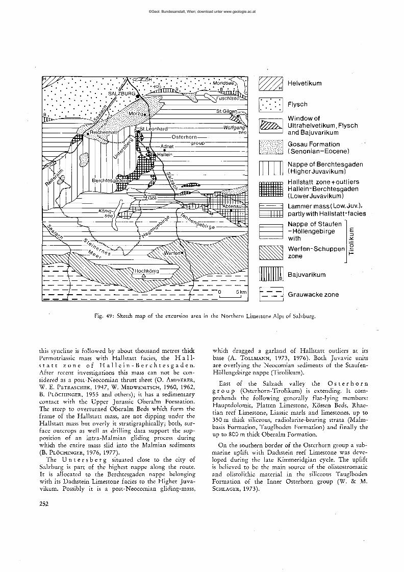
Helvetikum
Flysch
Window of Ultrahelvetikum, Flysch and Bajuvarikum
Gosau Formation (Senonian-Eocene)
Nappe of Berchtesgaden (Higher Juvavikum)
Hallstatt zone-t-outliers Hallein-Berchtesgaden (LowerJuvavikum)
Lammer mass(Low.Juv.), partly with Hallstatt-facies
Nappe of Stauten -Höllengebirge with
-
Werfen-Schuppen zone
Bajuvarikum
Grauwackezone
Fig. 49: Sketch map of the excursion area in the Northern Limestone Alps of Salzburg.
this syncline is followed by about thousand metres thick Permotriassic mass with Hallstatt facies, the H a 11-s t a t t z o n e of H a l l e i n - B e r c h t e s g a d e n . After recent investigations this mass can not be considered as a post-Neocomian thrust sheet (O. AMPFERER, W. E. PETRASCHEK, 1947, W. MEDWENITSCH, 1960, 1962,
B. PLÖCHINGER, 1955 and others); it has a sedimentary contact with the Upper Jurassic Oberalm Formation. The steep to overturned Oberalm Beds which form the frame of the Hallstatt mass, are not dipping under the Hallstatt mass but overly it stratigraphically; both, surface outcrops as well as drilling data support the supposition of an intra-Malmian gliding process during which the entire mass slid into the Malmian sediments (B. PLÖCHINGER, 1976, 1977).
The U n t e r s b e r g situated close to the city of Salzburg is part of the highest nappe along the route. It is allocated to the Berchtesgaden nappe belonging with its Dachstein Limestone facies to the Higher Juvavikum. Possibly it is a post-Neocomian gliding-mass,
which dragged a garland of Hallstatt outliers at its base (A. TOLLMANN, 1973, 1976). Both Juvavic units are overlying the Neocomian sediments of the Staufen-Höllengebirge nappe (Tirolikum).
East of the Salzach valley the O s t e r h o r n g r o u p (Osterhorn-Tirolikum) is extending. It comprehends the following generally flat-lying members: Hauptdolomit, Platten Limestone, Kössen Beds, Rhae-tian reef Limestone, Liassic marls and limestones, up to 350 m thick siliceous, radiolarite-bearing strata (Malm-basis Formation, Tauglboden Formation) and finally the up to 800 m thick Oberalm Formation.
On the southern border of the Osterhorn group a submarine uplift with Dachstein reef Limestone was developed during the late Kimmeridgian cycle. The uplift is believed to be the main source of the olistostromatic and olistolithic material in the siliceous Tauglboden Formation of the Inner Osterhorn group (W. & M. SCHLAGER, 1973).
252
©Geol. Bundesanstalt, Wien; download unter www.geologie.ac.at
Stop 9.5. Quarry of the Gartenau Portland cement work "Gebrüder Leube" (fig. 51)
Within the only 60 m thick series of Oberalm Formation (Tithonian-Berriasian) of the quarry one can observe a NNW-SSE striking anticline, in the center of which a 1 km long body of Haselgebirge (Upper Permian) could be mapped. This Haselgebirge characterizes the beginning of a cyclothem, which reaches over allodapic limestones (Barmstein Limestone) to a pelagic limestone (clayey Oberalm Limestone). The two higher cyclothems in the Oberalm Formation begin with a coarse allodapic sediment (Tonflatschen breccia) which shows a striking content of components of Upper Permian Haselgebirge and of Malmian shallow-water limestones. Thus, the cyclothems consist of mud-current breccia (Tonflatschen breccia), fluxoturbidites and turbi-dites. They indicate a rhythmic decrease of allodapic material towards the more pelagic sediments of the clayey Oberalm Formation in the coccolith-tintinnid-radiolarian facies.
A deep-drilling project proved the assumption that the Haselgebirge-body, which is to be found now in the center of the anticline, once glided into the Malmian sediment (B. PLÖCHINGER, 1969). An intercalated body of Triassic-Liassic rocks found by the drilling shows Hallstatt development. The process of synsedimentary gliding of Hallstatt outliers obviously began in the Tithonian and ended with the outliers of the Roßfeld mountain which are overlying the Upper Roßfeld Formation. The allodapic components indicate, that this process began with an undersea-updoming caused by a salt diapirism (fig. 53).
The Schrambach Formation (Lower Valanginian) in the quarry consists of aptychus- and ammonite-bearing gray limy marls and marly limestones. Above a thin layer of reddish marly limestones (Anzenbach Formation) the Lower Roßfeld Formation is developed by gray sandy marls (Upper Valanginian — Lower Hau-terivian). The sandstone member of the Lower Roßfeld Formation is missing here. Above the reduced sandy marls the conglomerate-(olistostrome-)rich Upper Roßfeld Formation of the higher Hauterivian is beginning. The Roßfeld Formation can be interpreted as a proceeding deep sea channel facies, the coarse-grained sediments of the Upper Roßfeld Formation as a small fan-deposit and slump-deposit (P. FAUPL & A. TOLLMANN, 1979).
Stop 9.6. Liassic Adnet Limestone (Adneter Kalk) in the Plattenquarry of Adnet (fig. 52)
On the western border of the Osterhorn group, at the village of Adnet, the Adnet Limestone has its type locality. Here the Adnet Limestone with its varieties follows the Rhaetian Limestones after a stratigraphic gap (M. SCHLAGER, 1960, map). The ammonite content proves its Lower Liassic to Middle Liassic age. The red
©Geol. Bundesanstalt, Wien; download unter www.geologie.ac.at
yf ^7
ambach Formation
SCHNEID / / / /
I ^-'
1
J with ' cyciothems / c,_4
ERWALD-ANTICLINE X
, - < \ C 3 \ \ /
^ Y Y Y °3 / \ \
/ \ \ / Haselgebirge \ ^ i t i t i o n \ 1 \ cyciothems \
1 /^~N \ c'"4 1 / Li.»„ic \ \
i i ^- Y 1/
/ ^ " ^ ' / Oberalm Formation \
\ Schrambach Formation
\ \ \ \ \ \ \
50 m
mill Gutrathsberg
\ v \ \
\ ^ \ \ V
\ \ \ \
- s
Lower Roßfeld
Formation
\ \ \ \ \ \ \
Fig. 51: Section through the area of the cement-quarry Gutrathsberg south of St. Leonhard in the Salzach-valley.
Quarternary
Adnet Limestone
s Vd. Storach
Rhätian Limestone (mostly Upper j Rhätian reef Lst.)
0 100 200 300 m I i . i I
Fig. 52: Sketch map of the Adnet area with the excursion point 9.6. (Platten quarry). After M. SCHLAGER, 1960.
254
©Geol. Bundesanstalt, Wien; download unter www.geologie.ac.at
nodular Adnet Limestone s. Str., up to 15 m thick, belongs to the Sinemurian and Lower Pliensbachian and may have been deposited in a relatively flat sea. Sub-solution which may have influenced the formation of the red Liassic Limestone certainly is also due to the condensation of the sediment. It is supposed, that the nodules were already present when the sediment was still unconsolidated. The nodules are considered as products formed by gliding during the diagenesis.
The up to 6 m thick overlying conglomeratic rock (Knollenbrekzie) of the Upper Pliensbachian contains fragments of different rock types: the Adnet Limestones and the crinoidal Hierlatz Limestone of the same age; the matrix is a pink crinoidal calcilutite (J. D. HUDSON & H. C. JENKYNS, 1969). The highest sediment of the quarry is formed by the so-called about 2 m thick "Scheck", which belongs to the Middle Liassic. It consists almost entirely of ovoid clasts of red calcilutite, cemented by white calcspar. After HUDSON & JENKYNS
it may be considered as a resedimented conglomerate in a continuously subsiding region.
S Sea of the Lower Cretaceous N
Fig. 53: Schematic section through a laterally deformed submarine salt-diapir, which caused olistolithic gliding during the Jurassics and the Lower Neocomian; n = Neocomian deposits, jo = Oberalm Formation, jp = Plassen Limestone, jr = siliceous radiolarite bearing Formation of the Lower Malmian, jd = Dogger deposits, jl = Liassic deposits, t = Triassic deposits in general, tw = Werfen Formation (Sky-thian), py = Haselgebirge (Upper Permian) with salt-dia-
pirism.
255
©Geol. Bundesanstalt, Wien; download unter www.geologie.ac.at