Embed Size (px)
Citation preview

1
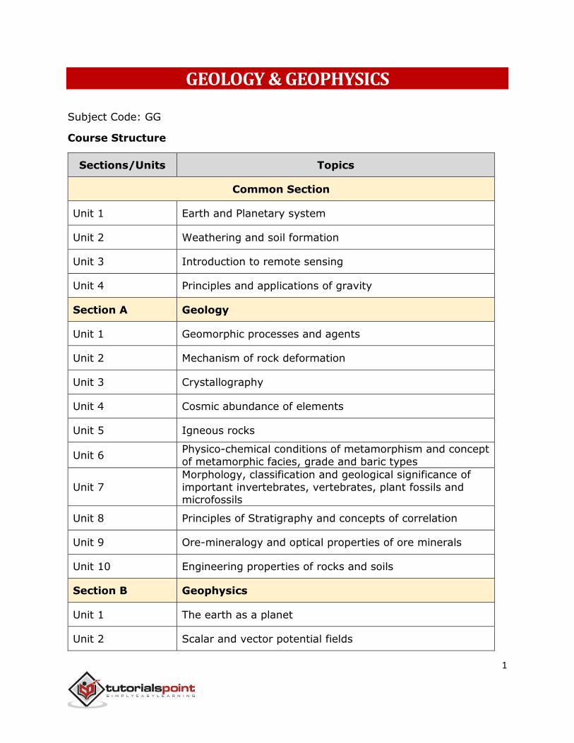
GEOLOGY & GEOPHYSICS
Subject Code: GG
Course Structure
Sections/Units Topics
Common Section
Unit 1 Earth and Planetary system
Unit 2 Weathering and soil formation
Unit 3 Introduction to remote sensing
Unit 4 Principles and applications of gravity
Section A Geology
Unit 1 Geomorphic processes and agents
Unit 2 Mechanism of rock deformation
Unit 3 Crystallography
Unit 4 Cosmic abundance of elements
Unit 5 Igneous rocks
Unit 6 Physico-chemical conditions of metamorphism and concept
of metamorphic facies, grade and baric types
Unit 7
Morphology, classification and geological significance of
important invertebrates, vertebrates, plant fossils and microfossils
Unit 8 Principles of Stratigraphy and concepts of correlation
Unit 9 Ore-mineralogy and optical properties of ore minerals
Unit 10 Engineering properties of rocks and soils
Section B Geophysics
Unit 1 The earth as a planet
Unit 2 Scalar and vector potential fields
2
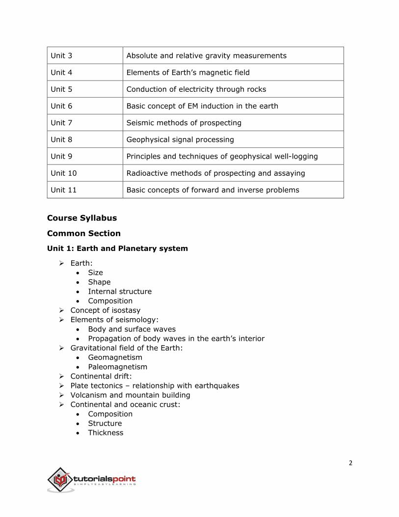
Unit 3 Absolute and relative gravity measurements
Unit 4 Elements of Earth’s magnetic field
Unit 5 Conduction of electricity through rocks
Unit 6 Basic concept of EM induction in the earth
Unit 7 Seismic methods of prospecting
Unit 8 Geophysical signal processing
Unit 9 Principles and techniques of geophysical well-logging
Unit 10 Radioactive methods of prospecting and assaying
Unit 11 Basic concepts of forward and inverse problems
Course Syllabus
Common Section
Unit 1: Earth and Planetary system
Earth:
Size
Shape
Internal structure
Composition
Concept of isostasy
Elements of seismology:
Body and surface waves
Propagation of body waves in the earth’s interior
Gravitational field of the Earth:
Geomagnetism
Paleomagnetism
Continental drift:
Plate tectonics – relationship with earthquakes
Volcanism and mountain building
Continental and oceanic crust:
Composition
Structure
Thickness
3
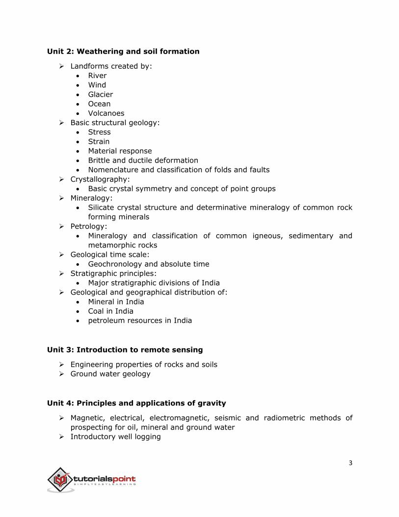
Unit 2: Weathering and soil formation
Landforms created by:
River
Wind
Glacier
Ocean
Volcanoes
Basic structural geology:
Stress
Strain
Material response
Brittle and ductile deformation
Nomenclature and classification of folds and faults
Crystallography:
Basic crystal symmetry and concept of point groups
Mineralogy:
Silicate crystal structure and determinative mineralogy of common rock
forming minerals
Petrology:
Mineralogy and classification of common igneous, sedimentary and
metamorphic rocks
Geological time scale:
Geochronology and absolute time
Stratigraphic principles:
Major stratigraphic divisions of India
Geological and geographical distribution of:
Mineral in India
Coal in India
petroleum resources in India
Unit 3: Introduction to remote sensing
Engineering properties of rocks and soils
Ground water geology
Unit 4: Principles and applications of gravity
Magnetic, electrical, electromagnetic, seismic and radiometric methods of
prospecting for oil, mineral and ground water
Introductory well logging
4
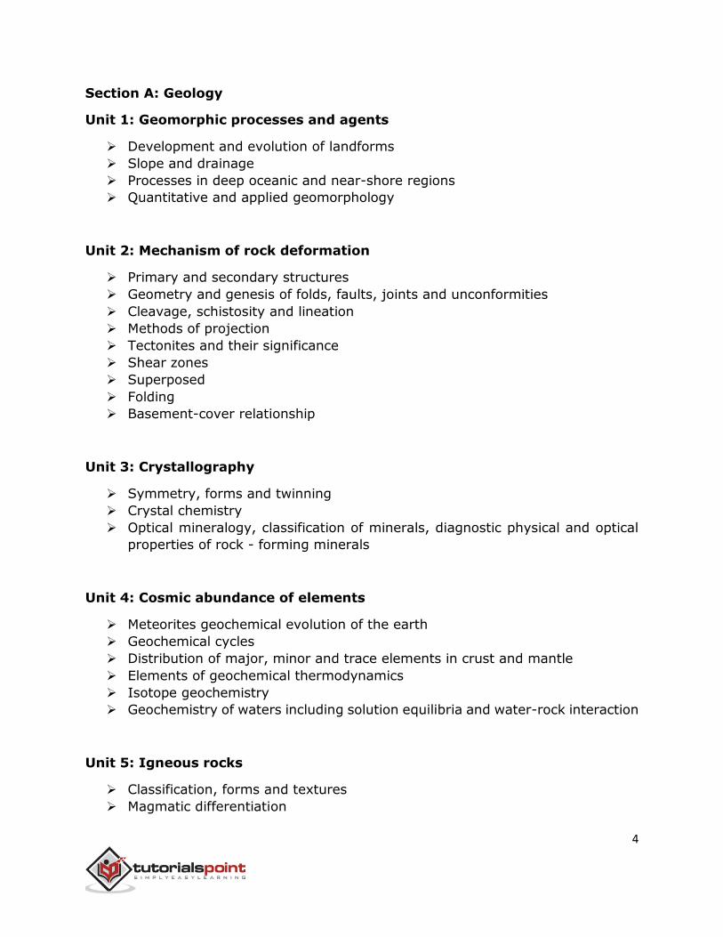
Section A: Geology
Unit 1: Geomorphic processes and agents
Development and evolution of landforms
Slope and drainage
Processes in deep oceanic and near-shore regions
Quantitative and applied geomorphology
Unit 2: Mechanism of rock deformation
Primary and secondary structures
Geometry and genesis of folds, faults, joints and unconformities
Cleavage, schistosity and lineation
Methods of projection
Tectonites and their significance
Shear zones
Superposed
Folding
Basement-cover relationship
Unit 3: Crystallography
Symmetry, forms and twinning
Crystal chemistry
Optical mineralogy, classification of minerals, diagnostic physical and optical
properties of rock - forming minerals
Unit 4: Cosmic abundance of elements
Meteorites geochemical evolution of the earth
Geochemical cycles
Distribution of major, minor and trace elements in crust and mantle
Elements of geochemical thermodynamics
Isotope geochemistry
Geochemistry of waters including solution equilibria and water-rock interaction
Unit 5: Igneous rocks
Classification, forms and textures
Magmatic differentiation
5
Binary and ternary phase diagrams
Major and trace elements as monitors of partial melting and magma
evolutionary processes
Sedimentary rocks – texture and structure
sedimentary processes and environments, sedimentary facies, provenance and
basin analysis
Metamorphic rocks – structures and textures
Unit 6: Physico-chemical conditions of metamorphism and concept of
metamorphic facies, grade and baric types
Metamorphism of pelitic, mafic and impure carbonate rocks
Role of fluids in metamorphism
Metamorphic P-T-t paths and their tectonic significance
Association of igneous, sedimentary and metamorphic rocks with tectonic
setting
Igneous and metamorphic provinces and important sedimentary basins of
India
Unit 7: Morphology, classification and geological significance of important:
Invertebrates
Vertebrates
Plant fossils
Microfossils
Unit 8: Principles of Stratigraphy and concepts of correlation
Lithostratigraphy, biostratigraphy and chronostratigraphy
Indian stratigraphy:
Precambrian
Phanerozoic
Overview of Himalayan Geology
Unit 9: Ore-mineralogy and optical properties of ore minerals
Ore forming processes vis-à-vis ore-rock association (magmatic,
hydrothermal, sedimentary, supergene and metamorphogenic ores)
Fluid inclusions as an ore genetic tool
Coal and petroleum geology:
Marine mineral resources
6
Prospecting and exploration of economic mineral deposits:
Sampling
Ore reserve estimation
Geostatistics
Mining methods
Ore dressing and mineral economics
Origin and distribution of mineral:
Fossil and nuclear fuel deposits in India
Unit 10: Engineering properties of rocks and soils
Rocks as construction materials
Role of geology in the construction of engineering structures including:
Dams
Tunnels
Excavation sites
Natural hazards
Ground water geology:
Exploration
Well hydraulics
Water quality
Basic principles of remote sensing:
Energy sources and radiation principles
Atmospheric absorption
Interaction of energy with earth’s surface
Aerial-photo interpretation
Multispectral remote sensing in visible
Infrared, thermal IR and microwave regions
Digital processing of satellite images
GIS:
Basic concepts
Raster and vector mode operations
Section B: Geophysics
Unit 1: The earth as a planet
Different motions of the earth
Gravity field of the earth, clairaut’s theorem, size and shape of earth
Geomagnetic field, paleomagnetism
Geothermics and heat flow
Seismology and interior of the earth
7
Variation of density, velocity, pressure, temperature, electrical and magnetic
properties of the earth
Earthquakes:
Causes and measurements
Magnitude and intensity
Focal mechanisms
Earthquake quantification
Source characteristics
Seismotectonics and seismic hazards
Digital seismographs
Unit 2: Scalar and vector potential fields
Laplace, Maxwell and Helmholtz equations for solution of different types of
boundary value problems in Cartesian, cylindrical and spherical polar
coordinates
Green’s theorem
Image theory:
Integral equations in potential theory
Eikonal equation
Ray theory
Unit 3: Absolute and relative gravity measurements
Gravimeters, land, airborne, shipborne and bore-hole gravity surveys
Various corrections for gravity data reduction – free air, bouguer and isostatic
anomalies
Density estimates of rocks
Regional and residual gravity separation
Principle of equivalent stratum
Data enhancement techniques, upward and downward continuation
Derivative maps, wavelength filtering; preparation and analysis of gravity
maps
Gravity anomalies and their interpretation – anomalies due to geometrical and
irregular shaped bodies, depth rules, calculation of mass
Unit 4: Elements of Earth’s magnetic field
Units of measurement
Magnetic susceptibility of rocks and measurements
Magnetometer land, airborne and marine magnetic surveys
8
Various corrections applied to magnetic data
IGRF
Reduction to pole transformation
Poisson’s relation of gravity and magnetic potential field
Preparation of magnetic maps
Upward and downward continuation
Magnetic anomalies-geometrical shaped bodies
Depth estimates
Image processing concepts in processing of magnetic anomaly maps
Interpretation of processed magnetic anomaly data
Applications of gravity and magnetic methods for mineral and oil exploration
Unit 5: Conduction of electricity
Conduction of electricity through:
Rocks
Electrical conductivities of metals
Nonmetals
Rock forming minerals
Different rocks
Concepts of D.C. Resistivity measurement
Various electrode configurations for resistivity sounding and profiling
Application of filter theory
Type-curves over multi-layered structures
Dar-zarrouck parameters
Reduction of layers
Coefficient of anisotropy
Interpretation of resistivity field data
Equivalence and suppression
Self-potential and its origin
Field measurement
Induced polarization
Time and frequency domain ip measurements
Interpretation and applications of ip, ground-water exploration, mineral
exploration, environmental and engineering applications
Unit 6: Basic concept of EM induction in the earth
Skin-depth
Elliptic polarization
In phase and quadrature components
9
Various EM methods, measurements in different source-receiver
configurations
Earth’s natural electromagnetic field
Tellurics, magneto-tellurics
Geomagnetic depth sounding principles
Electromagnetic profiling
Time domain EM method
EM scale modeling
Processing of EM data and interpretation
Geological applications including groundwater, mineral and hydrocarbon
exploration
Unit 7: Seismic methods of prospecting
Elastic properties of earth materials
Reflection, refraction and CDP surveys
Land and marine seismic sources
Generation and propagation of elastic waves
Velocity – depth models, geophones, hydrophones, recording instruments
(DFS), digital formats, field layouts
Seismic noises and noise profile analysis, optimum geophone grouping, noise
cancellation by shot and geophone arrays, 2D and 3D seismic data acquisition,
processing and interpretation
CDP stacking charts, binning, filtering, dip-move out, static and dynamic
corrections
Digital seismic data processing
Seismic deconvolution and migration methods
Attribute analysis
Bright and dim spots, seismic stratigraphy
High resolution seismic
VSP
AVO
Reservoir geophysics
Unit 8: Geophysical signal processing
Sampling theorem
Aliasing
Nyquist frequency
Fourier series
Periodic waveform
Fourier and Hilbert transform
10
Z-transform and wavelet transform
Power spectrum
Delta function
Auto correlation
Cross correlation
Convolution
Deconvolution
Principles of digital filters
Windows, poles and zeros
Unit 9: Principles and technique
Principles and technique of:
Geophysical well-logging
SP
Resistivity
Induction
Gamma ray
Neutron
Density
Sonic
Temperature
Dip meter
Caliper
Nuclear magnetic
Cement bond logging
Micro-logs
Quantitative evaluation of formations from well logs
well hydraulics and application of geophysical methods for groundwater study
application of bore hole geophysics in ground water, mineral and oil exploration
Unit 10: Radioactive methods
Radioactive methods of:
Prospecting and assaying of mineral (radioactive and non-radioactive)
deposits
Half-life
Decay constant
Radioactive equilibrium
G M counter
Scintillation detector
Semiconductor devices
11
Application of radiometric for exploration
Assaying and radioactive waste disposal
Unit 11: Basic concepts of forward and inverse problems
Ill-posedness of inverse problems, condition number, non-uniqueness and
stability of solutions
L1, L2 and LP norms, overdetermined, underdetermined and mixed
determined inverse problems
Quasilinear and non-linear methods including Tikhonov’s regularization
method, Singular Value Decomposition, Backus-Gilbert method, simulated
annealing, genetic algorithms and artificial neural network


![Geology Geophysics in Oil Exploration[1]](https://img.pdfslide.net/doc/110x75/55258648550346f36e8b48a1/geology-geophysics-in-oil-exploration1.jpg)