Embed Size (px)
Citation preview

<V o/«J
ILLINOIS STATE GEOLOGICAL SURVEYChampaign, Illinois
ISGS Guidebook 27
33rd Annual Meeting, April 1999
North-Central Section
Geological Society of America

Meeting Organizers
Dennis R. Kolata, Chair
Ardith K. Hansel, Vice Chair
Field Trip Coordinators
Janis D. TreworgyMyrna M. Killey
Scientific Editors
Janis D. TreworgyMyrna M. Killey
Jonathan H. Goodwin
Publications Coordinator
Ellen M. Wolf
Graphics
Cynthia A. Briedis
Pamella K. Carrillo
Jacquelyn L. HannahMichael W. Knapp
Photography
Joel M. Dexter
Editors
Thomas N. McGearyR. Stuart Tarr
William W. Shilts, Chief
Illinois State Geological Survey615 East Peabody Drive
Champaign, IL 61820-6964(217)333-4747http://www.isgs.uiuc.edu
ILLINOIS
DEPARTMENT OF
NATURALRESOURCES
printed with soybean ink on recycled paper
Printed by authority of the State of Illinois/1999/600

Geology, Hydrogeology, and Water Quality
of the Karst Regions of Southwestern Illinois
and Southeastern Missouri
Samuel V. Panno and C. Pius Weibel
Illinois State Geological Survey
Carol M. WicksDepartment of Geological Sciences, University of Missouri
James E. VandikeDivision of Geology and Land Survey, Missouri
ISGS Guidebook 27
Geological Field Trip 2: April 22-23, 1999North-Central Section, Geological Society of America33
rdAnnual Meeting, Champaign-Urbana, Illinois
April 24-25, 1999
sponsored by ^Illinois State Geological Survey +1***
q,615 East Peabody Drive ~* \<^PChampaign, IL 61820-6964
r\C\\ %S>
University of Illinois, Department of Geology %v^^*v
1301 West Green Street
Urbana, IL 61801-2999
U.S. Geological Survey, Water Resources Division221 North Broadway AvenueUrbana, IL 61801
w

Cover photo Falling Spring, a small cave spring near Dupo, Illinois, is shown as it appeared in 1998
(main photo) and in 1900 (inset photo). The spring discharges from a bedding-plane cave in the St. Louis
Limestone and was originally used as a water supply for domestic use and for steam locomotives (water
towers). The water towers disappeared with the steam locomotive, and the spring now provides water
for a nearby fishing pond.

CONTENTS
INTRODUCTION 1
Geology 1
Hydrogeology 4
Water Quality 4
Agrichemicals 4
Garbage 5
Private Septic Systems 5
KARST TERRAIN OF SOUTHWESTERN ILLINOIS 5
Stop 1: Falling Spring 6
Stop 2: Pond Collapse Sinkhole and Sparrow Creek Cave Spring 9
A. Pond Collapse Sinkhole 9
B. Sparrow Creek Cave Spring 10
Stop 3: Camp Vandeventer Karst Area 14
Stop 4: Illinois Caverns 18
HYDROGEOLOGY OF SHALLOW KARST GROUNDWATERSYSTEMS IN SOUTHEASTERN MISSOURI 25
Stop 5: St. Peter Sandstone Outcrop 25
Stop 6: Jerry Lawrence Sink 29
Stop 7: Doc White Spring 33
Stop 8: Ball Mill Resurgence 34
REFERENCES 36
FIGURES
1 Map showing field trip route, field trip stops, bedrock, sinkhole areas, Mississippi
and Missouri River flood plains, and Ste. Genevieve Fault Zone 2
2 Generalized stratigraphic column of middle Ordovician and middle Mississippian strata 3
3 Falling Spring, near Dupo, St. Clair County, Illinois (Stop 1) 7
4 Map showing geological and karst features of the sinkhole plain of Illinois 8
5 Sinkhole that formed during a heavy rainfall (Stop 2A) 10
6 Aerial view of Illinois' sinkhole plain 1
1
7 The entrance to Sparrow Creek Cave Spring (Stop 2B) 1
2
8 Solution-enlarged fissure entrance of Stemler Cave 1
3
9 The karst window at Camp Vandeventer near the Apache Campground (Stop 3) 1
5
1 Camp Vandeventer Spring (Stop 3) 1
6
1
1
Small cave spring adjacent to Camp Vandeventer Spring (Stop 3) 1
7
12 Outcrop of St. Louis Limestone along Fountain Creek (Stop 3) 17
13 Map of Illinois Caverns (Stop 4) 18
14 Stalagmites and flowstone in passages of Illinois Caverns (Stop 4) 19
15 Entrance to Illinois Caverns ( Stop 4) 21
16 Upper half of the original conduit that became Illinois Caverns (Stop 4) 22
17 Sinuous cave passages lined with flowstone in Illinois Caverns (Stop 4) 23
18 An abandoned upper passage in Illinois Caverns (Stop 4) 24
19 Scallops in Illinois Caverns (Stop 4) 25
20 Potholes in the top of limestone beds (Stop 4) 26
21 A series of rimstone pools in Cascade Canyon (Stop 4) 2722 Geologic map and field trip stops for the Perryville sinkhole plain 28

23 Exposure of Ordovician St. Peter Sandstone in a large sinkhole (Stop 5) 2924 Jerry Lawrence Sink (Stop 6) 30
25 Major springs, resurgences, and caves in the Perryville karst area 31
26 Cross section of Doc White Spring (Stop 7) 3427 Bottom of hemispherically-shaped Ball Mill Resurgence (Stop 8) 35

INTRODUCTION
The broad belt of the sinkhole plains of southwestern Illinois and southeastern Missouri straddles
the Mississippi River from roughly Cape Girardeau to north of St. Louis. As in most karst land-
scapes of the world, residents here confront sinkhole and water quality problems, sometimes on a
daily basis. This field trip will acquaint participants with the geology, hydrogeology, groundwater
geochemistry, and water quality of this karst terrain.
Geology
The karst terrain of southwestern Illinois and southeastern Missouri occurs primarily on Ordovi-
cian and Mississippian carbonate bedrock. The terrain generally developed on the uplands that
rise 60 to 100 m on either side of the broad valley of the Mississippi River and its floodplain (fig. 1).
Pleistocene glacial deposits are thin or absent in the area, although thick deposits of loess are
present.
In southwestern Illinois, karst landscapes formed on Mississippian carbonate (mostly limestone)
bedrock that subcrops beneath the Pleistocene deposits and is exposed in parts of St. Clair,
Monroe, Randolph, and Jackson Counties. In Missouri, the karst landscapes formed on Ordovician
and Mississippian carbonate bedrock in St. Louis, Jefferson, Ste. Genevieve, Perry, and CapeGirardeau Counties and in the city of St. Louis. The Ste. Genevieve Fault Zone traverses the karst
terrain in Perry County (fig. 1) and separates Mississippian carbonates to the north and northeast
from Ordovician carbonates to the south and southwest.
This band of shallow karst development extends from northeastern St. Louis County southeast-
ward to Cape Girardeau County, a distance of about 180 km, and ranges from about 24 km to
35 km wide. North of this area, the terrain continues to Alton, Illinois, and to the Lincoln Hills
(between the Mississippi and Illinois Rivers, just north of the area shown on figure 1).
Karst features are very common throughout this area, but intense karst development occurs in
Missouri primarily in the city of St. Louis, extreme northeast and southeast St. Louis County,
northeastern Ste. Genevieve County, and eastern Perry County, and in Illinois in west-central
St. Clair County and western Monroe County (fig. 1).
This karst terrain of Illinois and Missouri broadly delineates the boundary between the Ozark
Uplift to the southwest and the Illinois Basin to the east and northeast. The St. Francois Mountains,
a subdued range of mountains about 120 km south-southwest of St. Louis, Missouri, forms the
core of the Ozark Uplift. The deepest part of the Illinois Basin is in western Kentucky, more than
200 km to the southeast from St. Louis. Total structural relief in the Ozarks, where the Precam-
brian is exposed, is greater than 1 .5 km, but the top of the Precambrian in the Illinois Basin lies
more than 6 km below land surface (Bertagne and Liesing 1991). The average structural dip on
the east and southeast sides of the Ozark Uplift is about 20 m/km; steeper dips are generally
associated with faulting, local folds, or solution-induced collapse features. Major fault systems,
such as the Ste. Genevieve Fault Zone (fig. 1), generally reflect the Precambrian basementstructure and trend predominantly northwest and, to a lesser degree, northeast (Vineyard et al.
1981). The area has a long tectonic history, and, as a result of multiple tectonic deformation events
(Kolata and Nelson 1991), jointing (fracturing without displacement) is very common in the bedrock.
Joints are important in the karstification process because they allow surface water and ground-
water to move down into and through the bedrock, particularly the carbonate bedrock in the field
trip area. In addition to water and joints, carbon dioxide is necessary for the formation of karst.
As rainwater or snow melt seeps through the soil, carbon dioxide from the atmosphere and soil
bacteria dissolves in the water to form relatively small amounts of carbonic acid, which reacts
with and dissolves carbonate rock. Over tens to hundreds of thousands of years, this process has

Figure 1 Location map showing field trip route, field trip stops, and generalized occurrences of predominantly carbon-ate bedrock, sinkhole areas, Mississippi and Missouri River flood plains, and Ste. Genevieve Fault Zone.

~ZL
1 ,1, 1,/
ZZL
T~T
Aux Vases Sandstone
Ste. Genevieve Limestone
St. Louis Limestone
Salem Limestone
Warsaw Shale
Keokuk Limestone
Burlington Limestone
Fern Glen Formation
>ooenoUJ
1oo
crca
Q_ECO
1 1 1 1
1 1 1
1 1 1 1
1 1 1
1 1 1
1 1 1
1 I
—' I
I I — I—1 1 1
1 1
-I
1 1 1
1 1
1 1 1
1*
1""
1
1 1
1 / 1
/ 1 /1 1 1
1 1 1
ri 1 1 1
/ /- //-/—/
'/ /' ''/' ?/ '/•'/• *" ** •• *1. •••*"- •./. /. /./ / /
Kimmswick Formation
Decorah Formation
Plattin Formation
Joachim Dolomite
St. Peter Sandstone
Everton Formation
dissolved significant volumes of carbonate rock
as water migrated down vertical joints and along
bedding plane partings. Overtime, this process
enlarges the joint openings at the bedrock surface
and creates sinkholes in the overlying sediment.
Sinkholes are topographic depressions that charac-
teristically form in landscapes with internal drain-
age (drainage that occurs underground within the
bedrock instead of on land surface in streams).
They are abundant in the karst terrains of Illinois
and Missouri (fig. 1). These sinkholes typically
are nearly circular in plan view and range in width
from less than 1 m with a single drain into the
bedrock, to nearly 1 km in diameter with multiple
drains. Sinkholes act as natural drains for rainfall
and snow melt and concentrate the large volumeof water that flows rapidly into the underlying bed-
rock. Most groundwater in karst aquifers of this
area ultimately flows through fissures and conduits
that range from about 1 cm wide to more than 7 min diameter.
Fissures and conduits drain a large percentage
of the karst aquifer (Quinlan 1988). In addition to
enlarging joint openings at the bedrock surface,
dissolution enlarges the bedding plane partings
to form horizontal conduits and caves. Theseconduits and caves provide lateral routes for the
movement of the infiltrating water to springs, where
it discharges. In many respects, the karst "plumb-
ing" of sinkholes, conduits, and caves mimics
manmade storm sewer systems.
Karst development can be found in nearly any of
the many carbonate formations cropping out in
both southwestern Illinois and in southeastern
Missouri, but intense karst development is limited
to specific stratigraphic units. Of near-surface
bedrock units in southwestern Illinois, upper-middle
Mississippian (Meramecian) strata (fig. 2) are most
susceptible to karst development, particularly in
west-central St. Clair and west-central MonroeCounties. Karst features occur more commonlyin the St. Louis Limestone than in any other strati-
graphic unit, but the underlying Salem Limestone
and the overlying Ste. Genevieve Limestone (fig. 2)
also contain many karst features. The longest
caves in Illinois occur in the St. Louis Limestone
Figure 2 Generalized stratigraphic column of middle
Ordovician and middle Mississippian strata in the field
trip area (modified after Thacker and Satterfield 1977
and Weibel and Panno 1997; not to scale).

in Monroe and St. Clair Counties. In Missouri, intense karst development in northeastern and
southeastern St. Louis County occurs primarily in the St. Louis Limestone. In eastern Ste. Gene-
vieve County, the Ste. Genevieve Limestone hosts many sinkholes and caves. In eastern Perry
County, the middle Ordovician (Champlanian) Joachim Dolomite and Plattin Formation (fig. 2)
underlie extensive sinkhole plains and are host to hundreds of caves, including several of the longest
caves in the United States.
Hydrogeology
Groundwater flow in shallow karst aquifers consists of both diffuse flow and conduit flow (White
1988). Groundwater flow systems can be divided into discrete groundwater basins, which are
analogous to watersheds. Each basin consists of an area whose bedrock is rife with solution-enlarged
fractures, bedding planes, and conduits; some conduits may be large enough to be caves that drain
a specific recharge area. Groundwater is controlled, for the most part, by secondary permeability
features, including near-vertical fractures, bedding-plane partings, and solution-enlarged crevices
and conduits. Because of the abundance of sinkholes, recharge to shallow karst aquifers is rapid
(often minutes to hours) as surface water enters solution-enlarged crevices and the conduit systems.
The karst terrains of Illinois and Missouri include numerous groundwater basins whose karst aquifers
are open systems with water levels that are typically about 10 m below the soil-bedrock interface.
The distal end of a groundwater basin is characterized by one or more springs that discharge to, and
generally are the headwaters of, surface streams, which in this area ultimately discharge to the
Mississippi River.
Water Quality
Groundwater in this karst terrain is a calcium-bicarbonate-type water and is particularly suscepti-
ble to contamination through the extensive honeycombed system of conduits in carbonate bed-
rock. Recharge to, and movement of water within, karst aquifers is often comparable to surface
stream flow rates, and both entrained and dissolved contaminants are readily carried into the
aquifer. Shallow groundwater in karst landscapes does not have the benefit of the slow filtering
that is afforded to water infiltrating thick sequences of clay- and silt-rich glacial till or low-permeability
bedrock in other landscapes.
Most of the springs in southwestern Illinois and probably southeastern Missouri are contaminated
with bacteria and pesticides from agricultural activities, private septic systems, and natural sources
(Panno et al. 1996). Unfortunately, little data on water quality in this part of Missouri are available.
Contaminants from the land surface that are transported into shallow karst aquifers may include
relatively high concentrations of nitrate, bacteria, and organic chemicals. Water quality data for
the Perryville, Missouri, karst area are sparse. Limited data on major cations and anions in nine
springs are reported by Vandike (1985a).
Because of the relatively high bacterial counts in most springs in the sinkhole plain, drinking spring
water or allowing it to come in contact with an open wound is strongly discouraged. Visitors with
compromised immune systems are discouraged from coming in contact with the water because
of the presence of opportunistic pathogens.
Agrichemicals
Land use in the sinkhole plains of southwestern Illinois and southeastern Missouri is predominantly
agricultural. Row crops grown in the area are dominantly soybeans and com, but include milo,
alfalfa, wheat, and barley. Atrazine and alachlor are the most common herbicides used in this
area; other chemicals applied to the soils include anhydrous ammonia, potash, and phosphate
(Panno et al. 1996). Livestock operations are generally small hog and cattle raising facilities.

The herbicides atrazine and alachlor and elevated concentrations of nitrate are routinely found in
spring water in southwestern Illinois. The highest concentrations are present during the spring
season immediately following field applications. Herbicide concentrations in springs range from
0.1 to 98 ng/L; nitrate (as nitrogen) concentrations typically range from 4 to 6 mg/L. Herbicides were
found in as many as 55% of private wells sampled in April 1995 (Panno et al. 1996). Like that in
the springs, the occurrence of herbicides in wells is also seasonal.
Nitrate concentrations in water from bedrock wells of southwestern Illinois ranged from less than 0.1
to 30 mg/L (as nitrogen). Elevated concentrations of nitrate (above background) and concentrations
of nitrate exceeding the USEPA's MCL of 10 mg/L standard were found to occur in 17% and 10%of the wells, respectively (Panno et al., unpublished manuscript).
Garbage
Sinkholes have always been tempting sites for disposing of trash, household garbage, old appliances,
dead animals, and disabled vehicles. These materials contain contaminants, such as oil, gasoline,
bacteria, toxic chemicals from home cleaners and agricultural chemicals, that pollute the ground-
water. For example, water pumped from a karst window near Illinois Caverns and used as water
source for livestock was found to contain what appeared to be used motor oil (B. Schuckhardt,
personal communication, 1993). In addition, large objects discarded into sinkholes can plug the
sinkhole and alter the established drainage pattern. Localized flooding and/or accelerated erosion
can result.
Private Septic Systems
Recent improvements to Monroe County infrastructure, primarily along Illinois Route 3, have led
to a rapid increase in development and a rapid increase in the number of private septic systems.
Septic systems in southwestern Illinois commonly drain directly into sinkholes and introduce sep-
tic effluent into the groundwater. Panno et al. (1997a, b) demonstrated that drainage probably
from most of the private septic systems in Illinois' sinkhole plain exceeded state and local health
codes for fecal coliform content. For example, the effluent from 63% of 19 professionally-maintained
aeration-type septic systems in Monroe County did not meet state regulations for less than 400colonies of fecal coliform/100 mL water. Ten percent of the septic systems in the county were
actually cesspools (no treatment) with illegal overflows (Panno et al. 1997a). Such conditions
introduce poorly treated to untreated human waste directly into the shallow karst aquifer. At
least in part because of this practice, 55% of wells sampled in Monroe County in July 1995 tested
positive for coliform bacteria (Panno et al. 1996).
KARST TERRAIN OF SOUTHWESTERN ILLINOIS
Road Log
Miles Miles
from from last
start point
0.0 0.0 Road log begins at Exit 13, I-255 South and IL-157, between Centerville and
Dupo, St. Clair County, Illinois. Turn left (southeast) onto IL-157.
Turn right onto Triple Lakes Road.
Turn right onto Stolle Road.
Pass Stolle Quarry on left.
0.2 0.2
0.5 0.3
0.9 0.4

2.6 1 .7 Turn left onto McBride Avenue. Near the bluff, the road turns to the right and
becomes LePere.
3.8 1.2 Turn left onto Falling Spring Road.
3.9 0.1 Enter Falling Spring Park.
Stop 1: Falling Spring (Section 15, T1N, R10W, St. Clair County)
Falling Spring is a conduit spring and a waterfall that discharges from the steep limestone bluff
(fig. 3) at the eastern edge of the Mississippi River Valley. Most of the bluff, including the strata
within view, consists of St. Louis Limestone. The top of the bluff is capped by several meters of
Ste. Genevieve Limestone, which are not visible from this vantage point (Z. Lasemi and R. Norby,
personal communication, 1998). The spring discharges from a small cave opening, about 1 m high
by 2 m wide, along a bedding plane about 1 1 .5 m up from the base of this 50-meter bluff. This
cave spring is typical of southwestern Illinois caves, which formed along bedding plane partings
within limestone. Early explorers of this cave were able to follow the cave passage for several
hundred meters without having to crawl (Bowman and Reeds 1907). Falling Spring is one of a few
sites in this karst terrain that includes a scenic waterfall and a large deposit of tufa precipitated
beneath the cave spring entrance. Tufa is a porous deposit of calcium carbonate that is associ-
ated with calcareous springs and seeps.
The spring was used as a source of fresh water. Among other uses, early in this century, it sup-
plied water to steam locomotives that served nearby quarries. An iron trough near the base of
the tufa apron has supplied water to an adjacent fish pond. Other small cave openings are visible
in the bluff at approximately the same stratigraphic horizon. With the exception of the one immedi-
ately to the left (north) of the spring, most of these openings reportedly have little or no flow even
after a heavy rainfall (Bowman and Reeds 1907). Beneath the dry cave opening immediately to
the right (south) of the spring is a tufa deposit that is larger than that of the presently flowing
Falling Spring.
Falling Spring represents a discharge point for the small groundwater basin on the plateau above
(fig. 4). Because drainage of rainfall and snow melt is primarily through bedrock conduits, few
streams are present in the western part of this upland area.
The chemical composition of water from the spring is controlled by the dissolution of limestone.
This calcium-bicarbonate groundwater is saturated for most of the year with respect to calcite,
aragonite, dolomite, and quartz (Panno and Weibel, unpublished manuscript). The aeration,
agitation, and change in pressure (particularly from the spring to the base of the bluff) of the
calcium-bicarbonate-saturated water as it cascades down the bluff promotes the release of car-
bon dioxide from the water and causes tufa to precipitate along the bluff (Herman and Lorah 1987).
The aeration of the spring water along the bluff causes iron oxyhydroxide to precipitate (in a man-
ner similar to the precipitation of scale in water-well plumbing), which darkens the apron of tufa
along the bluff.
Davis et al. (1989) examined the tufa deposit and its biota in detail and described the deposit as
occurring as a 1 -meter-high, cone-shaped mound on a ledge above the base, and as a curtain
between the ledge and the base, 5 m wide and 5 cm thick at the top, and 7 m wide and up to 55 cmthick at the bottom. They reported that the most dominant organism in the apron was blue-green
algae, with the most abundant species being Phormidium incrustatum. Moss and a bacteria-laden
mucilage were also observed on the tufa. The strands of algae and moss are apparently being
encrusted by calcite and forming tangled clusters of parallel to subparallel, finger-like projections

Figure 3 Falling Spring, near Dupo, St. Clair County, Illinois, is a
small cave spring that discharges from the St. Louis Limestone about
midway up the high bluff. The spring is depositing tufa along the bluff
face. (Stop 1)
that make up the apron. X-ray fluorescence analysis determined that Ca, Mg, Si02 , and Fe were
dominant at the surface of the tufa (Davis et al. 1989).
Discharge from the spring at base flow is clear and was measured by Panno and Weibel at approxi-
mately 38 L/sec. During and/or following heavy rains, discharge typically is laden with suspended
solids, and the volume of discharge appears to be one or more orders of magnitude greater than
that at base flow. As with most springs in Illinois' sinkhole plain, the water quality of Falling Spring is
poor. The water is contaminated with a variety of coliform, fecal coliform (including Escherichia coli),
and fecal streptococcus bacteria derived from natural and anthropogenic sources. Given the
approximate recharge area for this spring (fig. 4), the likely sources of the fecal bacteria include
livestock, pets, private septic systems, and natural sources. Bacterial concentrations of water samples
from the spring (measured in colony-forming units per 100 mL of water) contained total aerobic
bacteria counts of 300,000 cfu, total coliform counts of 4,000 cfu, and fecal coliform and strepto-
coccus counts of 12 and 120 cfu, respectively (Panno et al., unpublished manuscript).

MISSOURI Non-carbonate bedrock
Warsaw & Burlington
-Keokuk Formations
Carbonate bedrock
Sinkhole areas
Mississippi River valley
Quaternary deposits
A Spring
/\' Sinkhole density
> 100 per square mile
rS/ Groundwater basin
boundary
\ ST. CLAIR CO.\\
\V
Waterloo * x
\
V L
MONROE CO.
I
RANDOLPH. CO.
Figure 4 Map showing generalized pertinent geological and karst features of the sinkhole plain of Illinois. Elongate
polygons indicate approximate groundwater basin boundaries (FS = Falling Spring basin, S = Stemler Cave basin,
KDR = Kruger's Dry Run basin, IC = Illinois Caverns basin, FP = Fogelpole Cave basin). Arrows within basin bounda-ries indicate general flow directions of ground water to discharge springs. Map modified after Mylius (1927), Weller andWeller (1939), and Weibel and Panno (1997).

3.9 0.0
4.0 0.1
5.2 1.2
6.8 1.6
9.4 2.6
11.0 1.6
Leave parking lot at Falling Spring Park.
Turn right onto LePere (turns into McBride Avenue).
Turn right onto Stolle Road and proceed east.
Proceed north onto Triple Lakes Road at fork. The road continues up onto
the highlands and the sinkhole plain.
Stop sign at Zion Church. Continue south.
Park along road next to sinkhole pond and recently formed sinkhole.
Stop 2: Pond Collapse Sinkhole and Sparrow Creek Cave Spring
A. Pond Collapse Sinkhole (Section 35, T1N, R10W, St. Clair County) In the northern half of
a larger, figure eight-shaped, 0.2-hectare sinkhole pond, a relatively new sinkhole drain formed
during a storm that dropped 23 cm of rain over a two-day period in April 1996 (fig. 5). Hydrostatic
pressure from the deepening pond initiated failure in the northern half of the pond, and water
rapidly drained into a small cave at the bottom of the new collapse zone. Immediately after it formed,
the cover-collapse sinkhole was characteristically cylindrical, 5.4 m in diameter, and 7.0 m deep.
The snow-white, tooth-like projections of the epikarst have formed in the fossiliferous, oolitic
Ste. Genevieve Limestone and are covered by reworked loess, mostly deposited as lacustrine
sediments.
Attempts by the owner to seal and fill the sinkhole have failed because a concrete plug wasinstalled after most of the hole was filled with soil and demolition debris. In spite of this effort,
water continues to drain through pathways that formed around the concrete plug. Ideally, grouting
of the bedrock conduit and the installation of a grouted-in-place, vertical drain pipe to the land sur-
face should have been completed prior to backfilling the hole (Sowers 1984). Presently, the sink-
hole is partially filled with demolition debris, and a pile of additional debris is adjacent to it awaiting
final remediation.
Sinkholes similar to this one are characteristic of the sinkhole plain of southwestern Illinois (fig. 6).
The largest sinkhole clusters by area and densest concentrations occur where the bedrock is the
middle Mississippian limestone sequence composed of the Salem, St. Louis, and Ste. Genevieve
limestones. The sinkhole plain is very large (fig. 4), and sinkhole densities are as great as 230 sink-
holes per township section (approximately equal to 1 mi2or 2.6 km2
)(Panno 1996).
In addition to the presence of soluble limestone bedrock, several other factors contribute to the
occurrence of sinkholes. The elevated upland of the Mississippi River Valley provides the topo-
graphic relief for water to percolate downward to the level of the Mississippi River. Where the
bluffs are steep, the area near the bluff edge commonly contains sinkholes and springs. To the
south of the village of Columbia, a steep bluff is absent, and there is a gap between the sinkhole
plains of St. Clair and Monroe Counties (fig. 4). This gap is underlain by the Columbia Syncline,
which contains a Pennsylvanian outlier dominated by noncarbonate shale. Sinkholes are virtually
absent within this area, except near the edge of the outlier, because the Pennsylvanian bedrock
inhibits karst formation in the underlying Mississippian carbonate rocks. A parallel structure, the
Waterloo-Dupo Anticline, occurs just east of the Columbia Syncline (fig. 4). Bedrock occurring
along the crest of this structure consists of Warsaw Shale and the stratigraphically lower Burlington
and Keokuk Limestones (Mylius 1 921 , Weller and Weller 1 939). Sinkholes are absent where the
Warsaw subcrops beneath the Quaternary mantle because the shale precludes karst formation.
Karst features occur in the Burlington and Keokuk Limestones in other areas (Panno et al. 1997c,

Figure 5 A roughly 5-meter-diameter sinkhole that formed literally overnight during a particularly heavy
rainfall. The white rock at the top of bedrock is the Ste. Genevieve Limestone and forms the epikarst.
(Stop 2A)
Wicks 1997), but have not been seen in this area. These limestone formations are noted for the
abundance of chert nodules and chert beds, which can have an arresting effect on epikarst forma-
tion. The area in which these units subcrop may be very small.
B. Sparrow Creek Cave Spring (Section 36, T1N, R10W, St. Clair County) Sparrow Creek
Cave Spring is a partially submerged, 5-meter-wide, 2-meter-high opening at the base of a steep,
loess-covered, blind stream valley (fig. 7). The stream issuing from the cave opening is the head-
water of Sparrow Creek and is one of the largest springs (by discharge) in the state. Sparrow Creek
Cave has a 245-meter-long, northward-trending main passage that leads to a sump, and a 300-meter-
long side passage that becomes constricted at its distal end (Sherrill 1989).
On the basis of the chemical composition of water samples and maps of Stemler and Sparrow
Creek Caves, this spring is believed to be the resurgence, or discharge point, of Stemler Cave(Panno and Weibel, unpublished manuscript). The entrance to Stemler Cave is at the bottom
of a relatively large, 23-meter-deep sinkhole, located about 3.5 km to the south. To the south of
the cave entrance, the passages are not accessible. Sherrill (1989) described the cave as having
over 1 .6 km of passages. The main passages in both Sparrow Creek and Stemler Caves are rela-
tively large with flowing streams that are filled with pebbles, cobbles, and imbricated limestone
slabs.
The Stemler Cave groundwater basin (fig. 4) is an elongate basin about 7 km long and 2 km wide
with an area of approximately 18 km 2. Recent dye tracing indicates that its boundaries extend even
farther south than shown on figure 6 (T. Aley, personal communication, 1998). The volume of ground-
water flowing through Stemler Cave at the southern entrance was measured at about 150 Useeat base flow. About three times that amount, approximately 470 L/sec, was measured discharging
at Sparrow Creek Spring. Sherrill (1989) measured a discharge of 1 1 ,360 L/sec from the spring
following a heavy rainfall. The cross-section morphology of the cave passages—for example,
10

11

Figure 7 Sparrow Creek Cave Spring is the distal end of Stemler Cave groundwater basin and is one of the
largest springs in Illinois. (Stop 2B)
they are elliptical in the deeper parts of Stemler Cave—and descriptions by the cave owners sug-
gest that during periods of high water, many parts of the cave system are completely flooded.
Illinois Caverns and Sparrow Creek, Stemler, Kruger's Dry Run, and Fogelpole Caves are
branchwork-type caves that occur primarily within the St. Louis Limestone. These caves initially
formed along bedding plane partings. Attempts to define some of the groundwater basins of these
caves have indicated that the local structural geology has a strong influence on the basin bounda-
ries and groundwater flow direction. The long axis of the shape of both the Falling Spring and
Stemler Cave groundwater basins parallels the axis of the Waterloo-Dupo Anticline (fig. 4). In
addition, the general northward direction of groundwater flow in these basins parallels the north-
ward plunge of this structure, whose crest is near Waterloo. In the southern part of Monroe County,
the groundwater basins of Kruger's Dry Run Cave, Illinois Caverns, and Fogelpole Cave are influ-
enced by the Valmeyer Anticline, a southeast-plunging fold (fig. 4). The Fogelpole Cave ground-
water basin parallels the anticlinal plunge to the southeast in both the long axis of its shape and
its general groundwater flow direction. The long axes of the two other groundwater basins are
oriented eastward and have groundwater flows in that direction, which suggests influences by
both the axial plunge and the dip of the northeast limb of the structure.
11.0 0.0
12.6 1.6
14.2 1.6
14.8 0.6
Leave Stop 2 and continue south on Triple Lakes Road.
Turn right onto Columbia Road.
Turn right onto Stemler Road.
To the right is the sinkhole entrance to Stemler Cave (fig. 8).
12

I '
21.1
m^ *
*.*" v.*" i «£ '~^1S
15.8 1.0
17.8 2.0
20.4 2.6
20.5 0.1
0.6
26.3 5.2
27.7 1.4
30.6 2.9
31.2 0.6
Figure 8 View of the solution-enlarged fissure entrance of Stemler Cave.
Water in the cave stream is just below geochemist Ivan Krapac.
Turn right onto Bluffside Road.
Turn right onto IL-158.
Stay to left to get to ramp for IL-3 south.
Cross over IL-3; entrance ramp curves sharply to the right. The exposures in
the roadcut are limestones in the upper Warsaw Formation.
Roadcut reveals an exposure of Salem Limestone with soil-mantled epikarst
features.
The highway becomes Business IL-3 entering Waterloo, IL.
Turn right onto IL-156
Turn right onto Trout Camp Road
Turn right onto lane that is entrance to Camp Vandeventer
13

32.0 0.8 Stop at Apache Campground
32.1 0.1 Continue on camp road through gates to parking area.
Stop 3: Camp Vandeventer Karst Area (Section 21, T2S, R10W,Monroe County)
Camp Vandeventer is owned by the Boy Scouts of America and provides camping, swimming,
hiking, and other outdoor activities amidst an intensely karstified and picturesque landscape. Thecamp straddles Fountain Creek, a relatively large stream that has dissected the sinkhole plain. TheBoy Scouts rented this site along the creek until 1928, when Judge Wilton M. Vandeventer, of
East St. Louis, purchased about 27.5 hectares for a permanent camp (Voris 1998). The camp is
in a truly unique geological setting, one that contains many sinkholes, a karst window, several
caves and springs, and a seasonally sinking and resurgent stream.
The winding entrance road passes by numerous sinkholes that display a wide range of size, depth,
and type (ponded and wetland). Across from the Apache Camp site is a karst window (fig. 9). Akarst window is a special type of sinkhole that results from the total collapse of the cave roof up to
the land surface. The water flowing through this "window to the underground" continues as an un-
derground cave stream and discharges at the spring at the base of the bluff just below the CampVandeventer mess hall (Aley and Aley 1998). The beds of limestone that crop out at the bottom of
the karst window are St. Louis Limestone. After heavy precipitation events, this sinkhole fills and
overflows its rim at the north edge into a small channel that flows under the entrance road and
cascades down a ravine to Fountain Creek. Recent slumping along the edges of this sinkhole
indicates that during these periods of high water, significant erosion of the overlying Quaternary
deposits occurs. During our visit to this site, a tracer test will demonstrate the connection between
this karst window and the mess hall spring.
Fountain Creek is the largest stream in Monroe County and, as is typical for fluvial channels in
karst terrains, has a reputation for being transformed into a raging torrent in a short period of time.
At times of low flow, Fountain Creek is a sinking (losing) stream. Voris (1998) reported that during
particularly dry periods, the stream may flow completely underground a few hundred meters
downstream from the mess hall. The creek water returns to the surface channel about 0.4 kmdownstream and eventually flows into the Mississippi River, about 16 km west of the camp. This
creek, which has dissected the limestone plateau, is the primary channel for small, unmappedgroundwater basins that drain the surrounding limestone bedrock. Rainfall and snow melt on the
plateau flows into nearby sinkholes and discharges into Fountain Creek at numerous springs at
the base of the bluffs along the creek (fig. 4), including the springs at Camp Vandeventer.
The spring at the base of the 12- to 14-meter-high bluff below the mess hall is relatively large and
discharges from a small cave in the St. Louis Limestone (fig. 10). The discharge of this spring,
known as Camp Vandeventer Spring, was measured at about 35 L/sec at near base flow (Aley
and Aley 1998). The spring flows directly into Fountain Creek through an entrenched channel that
at one time was a water source for the camp. As with most springs in the sinkhole plain, the water
from this spring is contaminated with fecal coliform bacteria; the spring is among the most severely
contaminated ones in the sinkhole plain. The dominance of Escherichia coli'in the spring water
suggests that private septic systems are a primary source of the contaminants (Panno et al.,
unpublished manuscript). The presence of optical brighteners in the spring water supports these
findings (Joan Bade, personal communication, 1997).
Another cave spring is located just to the west of this spring along the same bluff. Usually, the
discharge from this spring is almost negligible. The spring, however, is an overflow for Camp
14

Figure 9 The karst window at Camp Vandeventer near the Apache Camp-
ground. This feature formed when the roof of the cave through which the
water flows collapsed. The cave stream discharges in Fountain Creek
below the camp mess hall at Camp Vandeventer Spring. (Stop 3)
Vandeventer Spring during flooding events (Panno et al. 1996), when the discharge is a charac-
teristically high-energy, turbulent flow, and both the former and the latter springs discharge manyhundreds to over a thousand liters per second (fig. 11).
Across Fountain Creek from both of the springs is a spectacular, natural exposure of St. Louis
Limestone that displays numerous karst dissolution features (fig. 12). The upper portion of the
bluff contains vertical joints that allow surface water to move downward into the bedrock. Small
amounts of water move laterally along bedding planes and can be seen discharging from the bluff
wall and flowing down the bluff face. A small, sediment-filled cave passage is visible at the base
of the bluff.
15
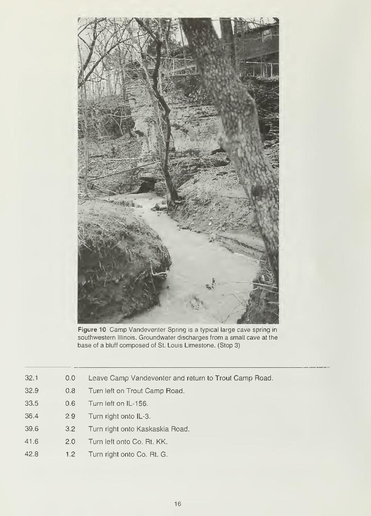
Figure 10 Camp Vandeventer Spring is a typical large cave spring in
southwestern Illinois. Groundwater discharges from a small cave at the
base of a bluff composed of St. Louis Limestone. (Stop 3)
32.1 0.0
32.9 0.8
33.5 0.6
36.4 2.9
39.6 3.2
41.6 2.0
42.8 1.2
Leave Camp Vandeventer and return to Trout Camp Road.
Turn left on Trout Camp Road.
Turn left on IL-156.
Turn right onto IL-3.
Turn right onto Kaskaskia Road.
Turn left onto Co. Rt. KK.
Turn right onto Co. Rt. G.
16

Figure 11 A small cave spring adjacent to Camp Vandeventer Spring is hydraulically connected to the
larger spring, but only during periods of high rainfall. At the time of this photograph, the water was at flood
stage and both caves were completely filled with water. (Stop 3)
Figure 12 View of outcrop of St. Louis Limestone along Fountain Creek, opposite Camp Vandeventer Spring.
Incipient vertical and horizontal conduits that have developed along joints and bedding planes in the bluff.
(Stop 3)
17

L0W Entrance
Crawl stoPs
?6 8
Lunch -r
Rroom 6
Canyon
Passage
Waterfall
Passage
i\12MushroomPassage
.20
HiddenPassage 15
Breakdown
RoomT Junction •
Capitol'
DomeMarvin's
Misery
—* stream flow
8 passage height
Cascade 10
Canyon
2
500 1000 ft
SE 1/4 NE 1/4 NW 1/4 Section 31
T3S R9W Renault quadrangle
Surveyed: compass and tape
April-May 1979 Windy City Grotto
15,850 (3.00 miles)
Passage Continuesto Sump
Figure 13 A map of Illinois Caverns, Monroe County, Illinois, showing features of interest within the cave (modified from
Department of Natural Resources 1996). Numbers along passages indicate cave height in feet. (Stop 4)
44.7
45.1
1 .9 Turn right at Illinois Caverns entrance lane.
0.4 Parking lot.
Stop 4: Illinois Caverns (Section 31, T3S, R9W, Monroe County)
Monroe County is the home of three of the largest caves in Illinois. Illinois Caverns is the second
largest of the three and the only cave in the state ever to have been commercially developed. Thecave is also known as Mammoth Cave of Illinois; the more famous Mammoth Cave in Kentucky
occurs in lithologically and stratigraphically similar strata. Illinois Caverns was a tour stop of the
1904 St. Louis World's Fair and was reportedly visited by President Theodore Roosevelt. Attempts
in 1901 and 1947 to make the cave into a commercial tourist attraction failed. The cave was sold
to the State of Illinois in 1985 and is now a State Natural Area that is open to self-guided tours
throughout the year. The cave has approximately 9.6 km of mapped passages (fig. 13); most contain
streams that are actively enlarging passages. The cave contains various types of speleothems,
dissolution features, and numerous cave-adapted biota that crawl, fly, and swim within the pas-
sages. Approximately 6,000 people visited the cave in 1997, and the number of visitors, which
include student groups from Illinois and Missouri, has been increasing annually.
Illinois Caverns was initially mapped by Bretz and Harris (1961). It is a branchwork-type cave that
formed along bedding planes within the St. Louis Limestone. It has a large trunk cave passage
and numerous tributary channels, some of which are locally controlled by joint orientations. Thecave entrance is at the bottom of an elliptical sinkhole that measures about 35 by 45 m; the floor
of the cave is about 33 m below the rim of the sinkhole. A stream flows down the center trunk of
the cave and discharges from Dye Spring, 5 km to the southeast (Wightman 1967), before flowing
into Horse Creek and eastward into the Kaskaskia River. The land surface above Illinois Caverns
contains many sinkholes. Land use is dominantly agricultural (primarily row crops and, to a lesser
extent, livestock).
Water enters Illinois Caverns from three sources: surface runoff through sinkholes, soil water or
groundwater temporarily perched on top of bedrock (the epikarst), and the shallow karst aquifer.
Runoff into sinkholes is episodic and occurs during and after significant rainfall events. Water
18

Figure 14 Stalagtites, stalagmites, and flowstone are abundant in the passages of Illinois Caverns. Speleothems
of this size may take thousands to tens of thousands of years to form and are evidence of the infiltration of
groundwater saturated by calcium carbonate. Top photo taken at the Lunch Room, bottom photo taken just east
of the Mushroom passage.
19

entering the cave system in this manner typically is laden with suspended solids and floods the
cave passages. Soil water or groundwater perched on top of limestone bedrock (within the epi-
karst) in some areas of the sinkhole plain may extend into the soil zone up to about 1 m or moreabove the soil-bedrock interface. The perched groundwater is channeled to areas of lower eleva-
tion where it may find a crevice or fracture through which it will seep (Panno et al. 1998). Wherewater seeps into Illinois Caverns, it either dissolves the cave ceiling to form chimneys or forms
flowstone within the passages (fig. 14). Groundwater seeping into the cave from the shallow karst
aquifer provides base flow for the cave stream and Dye Spring and is an approximation of the
overall water quality for the shallow karst aquifer within the Illinois Caverns groundwater basin
(Quinlan 1988).
The temperature of the stream and air in the cave is about 1 1 ° to 1 2°C and lacks significant sea-
sonal variation. Stream water is clear most of the time, but turns to a cloudy or coffee-brown color
during or immediately following a large rainfall. All water entering the cave may be contaminated
with relatively high counts of fecal coliform and other types of bacteria from natural sources, live-
stock, and private septic systems and is not fit to drink. Nitrate concentrations (as N) in cave stream
water rarely exceed 6.5 mg/L and average 5.4 mg/L. Although these concentrations exceed the
natural background of approximately 1 .4 mg/L (Panno et al. 1 996), they do not exceed the 1 mg/L
regulatory limit for drinking water set by the U.S. Environmental Protection Agency (U.S. EPA 1991).
The entrance to Illinois Caverns is a good example of a joint-controlled, solution-enlarged fracture
(fig. 15). It originally was a narrow joint in the limestone bedrock through which soil water and rain
water flowed down the approximately 26 m to reach the conduit system that is now Illinois Caverns.
Initially, the fracture probably was paper-thin in width. Over thousands to tens of thousands of
years, the limestone walls of the fracture dissolved as the slightly acidic water from the land surface
flowed past them. As the fracture widened, the volume of infiltrating water and the dissolution rate
of the fracture walls increased. When the fracture enlarged enough to allow soil to fall into it, sink-
hole formation was initiated. The fracture eventually widened to more than 1 to 1 .5 m, and as it
did so, the sinkhole grew to its present depth of approximately 26 m.
The original conduit, or protocave, that formed when slightly acidic, surface-derived water slowly
enlarged a channel between bedding planes is preserved in the ceiling in some parts of the cave
(fig. 16). One of the best examples in this cave is in Canyon Passage, where the original conduit
is visible in the ceiling. This protocave is about 10 to 15 cm wide and is the upper half of a tu-
bular conduit that follows the general trend of the cave. Over tens to hundreds of thousands of
years, as water migrated through the conduit, it enlarged downward and laterally to form the muchlarger passage that is present today.
Rectangular, elliptical, and canyon-shaped passages are present in Illinois Caverns. The cross-
sectional shapes of cave passages tell much about the origin and history of a cave. The shape
of a conduit or cave passage depends on hydrodynamic forces of groundwater flowing through
the cave (White 1988). Circular or elliptical passages form when conduits are completely filled with
groundwater during formation. Water then dissolves wall rock equally in all directions to form
"phreatic" cave passages. The downcutting of a free-surface cave stream forms sinuous canyon
passages with near-vertical walls (fig. 17). All other passage geometries are modifications or
combinations of elliptical and canyon-shaped passages (White 1988), although abundant stalac-
tites, stalagmites, flowstone, and breakdown tend to obscure these geometries.
Cave passages above the present stream passage can be seen in several places in the cave
(fig. 18). Excellent examples are located just above the first waterfall and where the path follows
a ladder to the dry upper passage and avoids the lower, wetter stream passage. The ceiling of the
upper passage also contains a remnant of the original bedding plane conduit.
20

Figure 15 The entrance to Illinois Caverns (looking up from the cave) is a solution-enlarged fracture at the
bottom of a sinkhole at Illinois Caverns State Natural Area. (Stop 4)
Scallops are smooth, shallow, concave indentations that are common along the walls of cave
stream passages (fig. 19). Scallops look as though an ice cream scoop was used to remove
portions of the rock. They are common where the stream flows across rock faces and are best
observed during periods of low water. Because they are dissolved out of the the limestone by
flowing, turbulent water, the geometry and size of the scallops can be used to determine the
direction of water flow and its velocity. A steeper face occurs on the upstream side. The larger
the size of the scallops (some exceed 30 cm in diameter), the slower the velocity of the water
flow that formed them, and vice versa (White 1988). The scallops in Illinois Caverns average
about 6 cm in diameter.
Throughout the cave are numerous bowl-shaped depressions that formed in the bedrock just
above and adjacent to the stream (fig. 20). Several are adjacent to the first downstream waterfall.
These "potholes" are the result of cobbles and pebbles being trapped within small depressions in
the stream bed. Eddy currents from flowing water during high-flow events cause the limestone or
chert cobbles and pebbles to swirl in a circular motion. This swirling, over time, creates hemi-ellipsoid
or bowl-shaped depressions that may range from 10 to 30 cm in diameter and 10 to 15 cm deep.
Many of the rocks that created these features have either been pulverized or removed from the
bottom of the potholes along the path by visitors.
Rimstone pools are among the most picturesque features in Illinois Caverns (fig. 21). Examples include
Cascade Canyon and Rimstone River, which are side passages made up of a series of pools.
Rimstone pools are small pools of water surrounded by dams of precipitated calcite. The pools
typically form within and near the point where side passages enter the main cave passage. Ground-
water that is saturated to supersaturated with calcite flows through small pools within natural
depressions and across relatively rough surfaces at the margins. The agitation at the margins
accelerates loss of carbon dioxide from the water and initiates precipitation of calcite (Hermanand Lorah 1987, White 1988). The calcite deposits form smooth, flowstone dams at the edges of
the pools. Rimstone pools are usually found in series, with one pool spilling into adjacent pools.
21

Figure 16 The upper half of the original conduit (protocave) that becameIllinois Caverns is preserved in the ceiling of Canyon Passage. (Stop 4)
Rubble zones, also referred to as breakdown, are piles of slab-shaped rocks that, prior to collaps-
ing, formed part of the ceiling of the cave. In Illinois Caverns, the best examples can be examined
in Breakdown Room. White (1988) stated that "the weight of rock above a solution cavity causes the
beds to sag slightly into the opening. If the beds are flat-lying, there is a concentration of shear
stress at the passage walls. ... If the beds do not have sufficient strength, they shear and collapse
into the cavity." Given enough time, groundwater flowing through and over the jumbled slabs of
limestone will eventually dissolve them. Collapse of rock slabs from the roof can reduce the spans
of individual beds and create a more arch-shaped roof that is structurally more stable than a wide
expanse of a single bed.
Twelve species of bats are found in caves and abandoned mines in Illinois. These subterranean
habitats are used for daytime roosts during the summer and serve as hibernacula in the winter.
Four state-listed and two federally-listed endangered species of bats occur in the state; the
federally-listed species are the Indiana bat (Myotis sodalis) and the gray bat (M. grisescens)
(Hofmann and Gardner 1990). The bats typically found in Illinois Caverns include the little brown
22

Figure 17 Sinuous cave passages, lined with flowstone, are typical of
the canyon passages of Illinois Caverns. This particular area contains
large stalactities. (Stop 4)
bat (M. lucifigus) and the eastern pipistrelle (Pipistrellus subflavus) (J. E. Gardner, personal com-munication, 1993). Cave salamanders are also plentiful in pools and on the walls of Illinois Caverns.
The cave salamander (Eurycea lucifiga), which is relatively small and orange with black spots, is
a true troglophile—its entire life cycle takes place in caves (Taylor and Webb 1998).
45.1 0.0
47.0 1.9
47.8 0.8
48.7 0.9
57.8 9.1
Leave Stop 4, turn left onto Co. Rt. G.
Turn right onto Co. Rt. KK.
Turn left onto Sportsman Road.
Turn right onto IL-3.
Enter Redbud; turn right and continue on IL-3.
23

63.1
67.6
73.5
82.2
83.4
89.7
95.0
98.5
Figure 18 An abandoned upper passage in Illinois Caverns, about 1 msquare and 8 m long, occurs just above the first small waterfall downstream
of the cave entrance. (Stop 4)
5.3 Enter Ruma.
4.5 Cross Kaskaskia River. Evansville is to the left.
5.9 Enter Ellis Grove.
8.7 Enter Chester. Turn right on by-pass road to bridge.
1 .2 Mississippi River bridge (MO-51 ).
6.3 Cross Ste. Genevieve Fault Zone.
5.3 Intersection of Business MO-51 and By-Pass MO-51. Proceed straight
on By-Pass MO-51.
3.5 I-55 overpass.
24

Figure 19 Scallops are common features through the cave; their size is an indicator of relative stream velocity
(Stop 4).
HYDROGEOLOGY OF SHALLOW KARST GROUNDWATERSYSTEMS IN SOUTHEASTERN MISSOURI
o.o 0.0
1.0 1.0
1.4 0.4
2.2 0.8
2.3 0.1
Road log resumes at Exit 129, I-55 and MO-51 at Perryville, Missouri. Turn
left (north) onto MO-51
.
Turn right (east) onto Edgemont Boulevard.
Turn right (south) onto Big Spring Boulevard.
Turn left (east) onto Veterans Drive.
Enter Perryville Country Club parking lot.
Stop 5: St. Peter Sandstone Outcrop (Perryville Country Club, T35N, R10E,
Perry County)
Stops in the Perryville karst area will explain the complex nature of its subsurface drainage, the
interrelationships between many of the area karst features, and the problems of urbanization in
this unique karst area (fig. 22).
25

Figure 20 Potholes in the top of limestone beds just above the stream channel formed when the stream
channel was not so deeply entrenched or at times of high water. Natural depressions in the rock trapped
cobbles and pebbles that spun and scoured the bowl-shaped features. (Stop 4)
Perryville is in the western part of Perry County where lower Ordovician (Canadian) dolomites and
sandstones are well below land surface, and younger Ordovician (Champlanian) strata crop out.
The St. Peter Sandstone generally forms the base for karst development in the Perryville karst
area. The St. Peter is a fine- to medium-grained quartzose sandstone that ranges from 20 to 60 mthick, and averages about 23 m at Perryville.
The St. Peter is unconformably overlain by the Joachim Dolomite, which forms the bedrock sur-
face throughout the central part of the Perryville karst area. The Joachim is about 76 m thick in
the area, and is yellow brown, silty dolomite containing limestone interbeds and minor shale. ThePlattin Formation, which overlies the Joachim, is about 106 m thick and forms the bedrock surface
throughout most of the eastern part of the Perryville karst area. It is a gray, finely crystalline to
sublithographic limestone with minor shale. The Joachim and Plattin both thicken to the east.
Although the Plattin is the youngest bedrock unit exposed in the Perryville karst area, a short
distance northeast of Perryville, extensive faulting along the Ste. Genevieve Fault system has
moved Mississippian rocks down enough to abut Ordovician Champlanian strata.
Both the Joachim and Plattin contain numerous karst features. Many sinkholes are found in the
Plattin, but the Joachim is host to the major caves and springs of the area. Perry County currently
has 622 known caves; most are in the Joachim Dolomite. Four major caves in eastern Perry County,
all within 8 km of Perryville, contain more than 1 12 km of mapped passages.
At this stop, the St. Peter Sandstone exhibits sinkhole development, which is unusual for the for-
mation (fig. 23). The sinkholes in the St. Peter are due more likely to solution activity and collapse
in the underlying Everton Formation than to dissolution of the St. Peter itself. About 10 hectares
on the west side of Big Spring Boulevard drain into the ephemeral stream that flows into a conduit
developed in the St. Peter Sandstone. The water is channeled underground a short distance to Big
26

Figure 21 A series of rimstone pools occurs in Cascade Canyon. (Stop 4)
Spring, which is one of the smaller springs in the Perryville karst area. Drainage through the conduit is
somewhat sluggish, though, and water floods over Big Spring Boulevard after heavy rainfall. (Note
to geologists who also golf: The sinkhole is played as a hazard and is filled with golf balls.)
Leave Stop 5; backtrack to Edgemont Boulevard by way of Big Spring Boulevard.
Turn right (east) onto Edgemont Boulevard.
Turn left (north) onto Waters Street.
Turn left (west) onto Grand Street.
Turn right (north) onto Bruce Street.
2.3 0.0
3.6 1.3
4.9 1.3
5.3 0.4
5.6 0.3
27

Figure 22 Geologic map and field trip stops for the Perryville sinkhole plain portion of the field trip (modified
from Vandike et al. 1989).
28

Figure 23 An exposure of Ordovician St. Peter Sandstone in a large sinkhole at the Perryville Country
Club shows dissolution features. (Stop 5)
5.7
5.8
0.1 Turn right (east) onto Star Street.
0.1 Park at end of Star Street.
Stop 6: Jerry Lawrence Sink (Perryville, T35N, R10E, Perry County)
Jerry Lawrence Sink is an eastward extension of a large shallow uvala in the Joachim Dolomite
in the western part of Perryville. Before extensive modification and drainage improvement, the
sinkhole flooded after heavy rainfall. During construction activity in the sinkhole, Streiler City Cavewas rediscovered. The entrance of the cave, which was choked with accumulated debris and brush,
was excavated. A 1 -meter-diameter concrete pipe was laid from the entrance to about 60 m south-
west. Two storm-water drainage wells were constructed to channel water from the sinkhole into
the upstream reaches of the cave (fig. 24A). The pipe leading into the mouth of the cave is nowan overflow inlet and only functions when storm-water drainage wells are overwhelmed by heavy
runoff (fig. 24B). A once-planned subdivision that would have been subject to flooding during
heavy rainfall is now a storm-water retention and disposal basin. In addition, Perryville has recrea-
tional facilities in the sinkhole.
Jerry Lawrence Sink continues to the west on the other side of Bruce Street. This westward exten-
sion drains nearly 1 .2 km 2. The water is channeled into the subsurface through a throat just west of
Bruce Street. Water enters a conduit related to the Streiler City Cave and eventually emerges at
several karst resurgences to the east.The hydrogeology of the Perryville karst area is complex.
Vandike (1985b) used extensive dye tracing to determine the outflow points of runoff in the karst
area (fig. 25). The Perryville sinkhole plain covers about 41 km 2
and has continuous internal
29

.
*5«%?$N#i
Figure 24 Jerry Lawrence Sink is a large sinkhole that is used to dispose of surface runoff via Streiler City Cave.
Water is channeled through exposed segments of the cave (top photo) and cascaded down caged entrances
(bottom photo) to the main part of the cave system. (Stop 6)
30

Figure 25 Major springs, resurgences, and caves in the Perryville karst area (modified from Vandike 1985b).
%%**'»**
00^
31
01 \$$
w fcfitfw2$

drainage. Springs and karst resurgences along the land surface drain to the northwest and south-
east. Discharge water that had entered the subsurface through sinkholes in the sinkhole plain is
drained to the northwest (Blue Spring Branch) and southeast (Cinque Hommes Creek). Twomajor cave systems transport the water. The Crevice Cave system, which consists of several
hydrologically connected caves (including Crevice, Mertz, Klump , Streiler City, and Zahner Caves),
drains approximately the eastern two-thirds of the Perryville sinkhole plain. The Moore CaveSystem, which includes Berome Moore Cave, Tom Moore Cave, and other smaller caves, drains
approximately the western third. These cave systems are among the largest in Missouri. Crevice
Cave alone has more than 43 km of mapped passages and is strongly joint controlled. The MooreCave system has more than 27 km of mapped passages.
Dye tracing has shown that water entering sinkholes in Perryville primarily drains through a south-
ern branch of the Crevice Cave system and emerges at several hydrologically connected springs
and karst resurgences. The base-flow outlet of the system is the Mertz Resurgence, about 5 kmeast of Perryville on the north side of Cinque Hommes Creek. Mertz Resurgence discharges
much of the runoff entering the karst groundwater system in Perryville; but upstream from the
resurgence are at least four other groundwater outlets that can, depending on hydraulic head in
the cave system, discharge a portion of the water. Mertz Resurgence drainage in Perryville is
divided into three subbasins: Circle Drive Resurgence, Heberlie Resurgence, and Dry Run Branch
Estavelle. Circle Drive Resurgence and Heberlie Resurgence are essentially overflow outlets for
the subsurface drainage network and discharge water only after heavy rainfall. Depending on run-
off levels, Dry Run Branch Estavelle can function as a spring or sinkhole.
Only a portion of the karst recharge discharges from Circle Drive and Heberlie Resurgences and
Dry Branch Estavelle. The remainder continues downstream in the conduit system toward the
Mertz Resurgence. Doc White Spring, an intermittent spring between Perryville and Mertz Resur-
gence, is another overflow outlet for this karst groundwater system. It is dry much of the time, but
begins discharging water after moderate runoff occurs and before the other overflow outlets in
Perryville begin discharging. Like other upstream resurgences, it discharges only a portion of the
water entering the conduit system. The remainder is transported on to Mertz Resurgence.
Jerry Lawrence Sink and Streiler City Cave are near the upstream end of this karst drainage
system. Dye introduced into Jerry Lawrence Sink is recovered only at the Mertz Resurgence
during relatively dry weather. If there is ample runoff to cause discharge at Doc White Spring,
dye will also emerge there. After very heavy rainfall, dye will also be recovered from Circle Drive
Resurgence.
Problems with sinkhole drainage date back to the early days of the city. For years, private individu-
als installed drainage wells in the bottoms of sinks. Storm-water drainage wells placed in Jerry
Lawrence Sink are a common sight in Perryville. Today, the city has easements on many of the
drainage wells and installs most of the new ones. Sinkhole modification is controlled by city ordi-
nance, which requires a permit before modifications can take place. Most of the drainage wells
are less than 6 m deep and consist of large-diameter concrete pipe. The sinkholes are excavated
until bedrock openings are encountered. Precast concrete pipe is set over the bedrock openings,
a gravel pack is placed around the lower part of the concrete pipe, and the hole is backfilled to
original grade. A trash rack completes the installation (Vandike 1987).
Further development in sinkholes will soon be limited. In a study funded by the city of Perryville,
Vandike (1988) calculated expected water levels in 58 sinkholes in the city under various rainfall,
runoff, and outflow conditions. This information will be used by the city to establish minimum con-
struction elevations for sinkholes in Perryville.
32

5.8 0.0
5.9 0.1
6.2 0.3
7.5 1.3
8.1 0.6
9.2 1.1
9.3 0.1
Leave Stop 6.
Turn left (south) onto Bruce Street.
Turn left (east) onto MO-51 . Stay on MO-51
Turn right (south) onto MO-61.
Turn left (north) onto St. Rt. E.
Turn right (east) onto unnamed lane.
Park at end of lane near barn.
Stop 7: Doc White Spring (Section 16, T35N, R11E, Perry County)
Doc White Spring (fig. 26) is about 1 .6 km east of Perryville, in the upper watershed of an unnamedtributary of Cinque Hommes Creek. Like many karst groundwater outlets, it is intermittent. Thewater rises at the base of a low bluff of Joachim Dolomite from a sub-vertical cave opening. Water
originally flowed through breakdown and debris. In 1984, a backhoe was used to remove debris
blocking the spring opening in hopes of finding an entrance for exploring and mapping this portion
of the Crevice Cave conduit system. The spring was found to rise from a submerged opening at
the side of an oblong room about 6 m long and 2 m wide. Even during dry weather, there is insuf-
ficient air space for exploration in the conduit. Discharge from the spring is highly variable. Thespring ceases to flow during dry summer weather, but after heavy rainfall will discharge an esti-
mated 1,100 L/sec.
Perhaps more fascinating than the spring itself is the geomorphology of the immediate setting. Thearea near the spring and part of the spring branch are collapsed cave passages. A bedrock pillar,
some tens of meters in diameter, 3 m high, and less than 1 m from the spring, appears to be a rem-
nant of cave wall between intersecting cave passages. At the base of the pillar, on the spring side, is a
small, vertical-sided sinkhole about 1.2 m in diameter and depth. Even after the spring stops
flowing in dry weather, water continues to flow through the bedding-plane opening at the base of
the sink. Dye introduced into this small sinkhole was recovered in the cave stream of Mertz Cave,
1.4 km to the northeast, and Mertz Resurgence, 1.9 km northeast of Doc White Spring.
Doc White Spring is a middle-level overflow outlet for the conduit system that channels water from
the western part of the Perryville sinkhole plain to Mertz Resurgence. Like Circle Drive Resurgence
and Dry Run Branch Estavelle, it discharges only a portion of the water flowing through the conduit
system. Mertz Resurgence is the outflow point for the water remaining in the system downstream
from Doc White Spring.
Mertz Resurgence is the downstream entrance of Mertz Cave. A completely water-filled passage
in lower Mertz Cave prevents entry from the resurgence. The only usable entrance to Mertz
Cave is through a deep sinkhole 1 .3 km northeast of Doc White Spring. Mertz Cave contains about
3.6 km of mapped passages. It is actually a downstream continuation of Crevice Cave. Dye tracing
has proved the hydraulic connection, but a flooded passage prevents cavers from making a
physical connection. Water from the Circle Drive Resurgence, Dry Run Branch Estavelle, Heberlie
Resurgence, and the Doc White Spring recharge area is thought to enter Mertz Cave about 0.7 kmupstream from the sinkhole entrance.
At Mertz Resurgence, water flows from a horizontal cave passage in the Joachim Dolomite. Plattin
Formation caps the hill at the top of the 30-meter-high bluff above the spring outlet. The cave can
33

ft
10-
20 ft
Doc White Spring abandoned stream channel
to Cinque Hommes Creek/ sinkhole
i'
i i i i- i *~r;r~i i t t
C_I i — r r
recharge from much of
Perryville and surrounding areato Mertz Cave andMertz Resurgence
Figure 26 Diagrammatic cross section of Doc White Spring, looking north-northeast (from Vandike et al. 1989).
Groundwater discharges from the spring, flows on the land surface for a short distance, and disappears into a sink-
hole. (Stop 7)
be followed upstream only a short distance until the passage siphons. This resurgence is the only
perennial spring of the Crevice Cave system. It is about 24 m lower than Doc White Spring and
46 m lower than Circle Drive Resurgence. Flow from Mertz Resurgence during very dry weather
may decline to less than 6.3 Usee, but after very heavy rainfall flow has been visually estimated at
more than 1 80 L/sec.
9.3 0.0
10.5 1.2
12.9 2.4
13.5 0.6
15.7 2.2
16.3 0.6
17.1 0.8
Leave Stop 7; backtrack to MO-61 along St. Rt. E.
Turn right (west) onto MO-61
.
Turn right (north) onto St. Rt. V.
Bear right.
Bear right at fork in road.
Bear left at fork in road.
Park at Ball Mill Resurgence parking area.
Stop 8: Ball Mill Resurgence (Section 24, T36N, R10E, Perry County)
The previously discussed Perryville karst area groundwater outlets drain into Cinque Hommes Creek,
which bounds the area to the southeast. Blue Spring Branch forms the northwest boundary of the
karst area, and along its reach are several important and interesting springs and karst resurgences.
The most unusual karst resurgence draining the Perryville sinkhole plain is Ball Mill Resurgence
(fig. 27), located at the base of a 12-meter-high bluff of Joachim Dolomite, a short distance south
of Blue Spring Branch. The feature is a very large pothole and topographically looks more like a
34
Figure 27 C.P. Weibel and S.V. Panno stand at the bottom of hemispherically-shaped Ball Mill Resurgence.
The cobbles that line the resurgence scoured the feature in a manner similar to that of the bowl-shaped features
of Illinois Caverns. (Stop 8)
sinkhole than a spring. The rise basin, about 6 m in diameter and 2.4 m deep, is completely dry
most of the time. After light rainfalls, it probably channels a minor amount of runoff into the ground-
water system. After a very heavy rainfall, its function, although brief, cannot be mistaken. Water
surges through the well-rounded cobbles at the bottom of the basin and flows down to Blue Spring
Branch. The natural milling of rocks striking each other when flood water rushes upward through
the cobbles creates the rock "balls" covering the floor of the resurgence. Fresh rock spalling from
the bluff above keeps the mill supplied with abrasives and raw materials to replace the dolomite
cobbles as they are ground away.
The very brief functioning of the resurgence after heavy precipitation indicates that its recharge
area is fairly small but very open and interconnected. Vineyard (personal communication, 1984)
visited it after a heavy rainfall and estimated the observed resurgence discharge at 0.5 L/sec.
Vandike (1985b), using high-water marks and channel characteristics, estimated peak flow at
over 1.5 L/sec. Ball Mill Spring, another groundwater outlet between Ball Mill Resurgence and
Blue Spring Branch, has a well-sustained base flow and may be a lower level outlet for the con-
duit system that channels water to Ball Mill Resurgence.
17.1 0.0
23.7 6.6
26.0 2.3
28.9 2.9
Leave Stop 8, return to MO-61
Turn right (east) onto MO-61.
Turn left (south) onto MO-51.
Turn left (north) onto I-55.
35

REFERENCES
Aley, T., and C. Aley, 1998, Groundwater tracing and recharge area delineation study for twokarst study areas in Monroe County, Illinois: Unpublished report to the Mississippi Karst
Resource Planning Committee, Waterloo, IL, 66 p.
Bertagne, A.J., and T.C. Liesing, 1991 , Interpretation of seismic data from the Rough Creek Grabenof western Kentucky and southern Illinois, in M.W. Leighton, et al., eds, Interior Cratonic Basins:
American Association of Petroleum Geologists, Memoir 51, p. 199-208.
Bowman, I., and C.A. Reeds, 1907, Water Resources of the East St. Louis District: Illinois State
Geological Survey Bulletin 5, 128 p.
Bretz, J.H., and S.E. Harris, Jr., 1961, Caves of Illinois: Illinois State Geological Survey Report
of Investigation 215, 87 p.
Davis, J.S., D.G. Rands, and M.K. Hein, 1989, Biota of the tufa deposit of Falling Springs, Illinois,
U.S.A.: Transactions of the American Microscopical Society , v. 108, no. 4, p. 403-409.
Department of Natural Resources, 1996, Illinois Caverns, State Natural Area: Illinois Department
of Natural Resources brochure.
Herman, J. S., and M.M. Lorah, 1987, CO2 outgassing and calcite precipitation in Falling Spring
Creek, Virginia, U.S.A.: Chemical Geology, v. 62, p. 251-262.
Hofmann, J.E., and J.E. Gardner, 1990, Bats—Remarkable creatures of the night: Spectrum
—
The Journal of the Illinois Science Teachers Association, v. 16, p. 15-18.
Kolata, D.R., and W.J. Nelson, 1991, Tectonic history of the Illinois Basin, in M.W. Leighton,
et al., eds., Interior Cratonic Basins: American Association of Petroleum Geologists,
Memoir 51, p. 263-285.
Mylius, L.A., 1921, Oil and Gas in Monroe County, Illinois: Illinois State Geological Survey, Press
Bulletin no. 7, 8 p.
Panno, S.V., 1996, Water quality in karst terrain: The Karst Window, v. 2, no. 2, p. 2-4.
Panno, S.V., I.G. Krapac, C.P. Weibel, and J.D. Bade, 1996, Groundwater Contamination in
Karst Terrain of Southwestern Illinois: Illinois State Geological Survey Environmental
Geology 151, 43 p.
Panno, S.V., E.C. Storment, C.P. Weibel, and I.G. Krapac, 1997a, Bacterial species isolated from
groundwater from springs, caves and wells in southwestern Illinois' sinkhole plain and their
potential sources: Proceedings of the Annual Environmental Laboratories Seminar, October 2-3,
Springfield, IL, p. 1-4.
Panno, S.V., C.P. Weibel, and I.G. Krapac, 1997b, Bacterial contamination of groundwater from
private septic systems in Illinois' sinkhole plain—Regulatory considerations, inThe Engineering
Geology and Hydrogeology of Karst Terrains, B.F. Beck and J.B. Stephenson, eds., Proceedings
of the Sixth Multidisciplinary Conference on Sinkholes and the Engineering and Environmen-
tal Impacts of Karst, Springfield, MO, April 6-9, 1997, p. 443-447.
Panno, S.V., C.P. Weibel, and W. Li, 1997c, Karst Regions of Illinois: Illinois State Geological Survey
Open File Series 1997-2, 42 p.
Panno, S.V., K.C. Hackley, and C.P. Weibel, 1998, The chemical and isotopic composition of
groundwater associated with a demolition landfill in a karst terrain: Illinois State Geological
Survey Final Report to the City of Columbia, 15 p.
36

Panno, S.V., E.C. Storment, C.P. Weibel, and I.G. Krapac, unpublished manuscript. The role of karst
terrain, private septic systems and agricultural activities on bacterial contamination of ground-
water in southwestern Illinois.
Panno, S.V., and C.P. Weibel, unpublished manuscript. The delineation of four large groundwater
cave basins in lllinois's sinkhole plain.
Quinlan, J.F., 1988, Protocol for reliable monitoring of groundwater quality in karst terrains: Proceed-
ings from the International Association of Hydrologists 21st Congress, Guilin, China, p. 888-893.
Sherrill, J., 1989, Stemler Cave-Sparrow Spring drainage basin, in Southern Illinois MVOR 89
Decca Mecca: Mississippi Valley-Ozark Region, National Speleological Society, Windy City
Grotto, p.15-16.
Sowers, G.F., 1984, Correction and protection in limestone terrain, in B.F. Beck, ed., Sinkholes
—
Their Geology, Engineering and Environmental Impact: Proceedings of the First Multidiscipli-
nary Conference on Sinkholes, Rotterdam, Netherlands, A.A. Balkema, p. 373-378.
Taylor, S.J., and D.W. Webb, 1998, The fragile fauna of Illinois caves: The Illinois Steward, p. 2-6.
Thacker, J.L., and I.R. Satterfield, 1977, Guidebook to the Geology along lnterstate-55 in Missouri:
Missouri Department of Natural Resources, Geological Survey, Report of Investigations 62, 137 p.
U.S. Environmental Protection Agency, 1991, National primary drinking water regulations, final
rule: U.S. Federal Register, 40 CFR, Parts 141, 142 and 143, v. 45, no. 20, p. 3526-3594.
Vandike, J.E., 1985a, Movement of shallow groundwater in the Perryville karst area, southeastern
Missouri: Missouri Department of Natural Resources, Division of Geology and Land Survey,
Water Resources Report No. 40, 52 p.
Vandike, J.E., 1985b, Movement of shallow groundwater in the Perryville karst area, southeastern
Missouri: Missouri Department of Natural Resources, Division of Geology and Land Survey,
Misc. Pub. No. 44, 57 p.
Vandike, J.E., 1987, Use of stormwater drainage wells in Missouri, in International Symposium on
Class V Injection Well Technology: Proceedings, Underground Injection Practices Council,
Oklahoma City, OK, 73105, p. 160-178.
Vandike, J.E., 1988, Using digital watershed modeling to estimate sinkhole-flooding potential at
Perryville, Missouri: Missouri Department of Natural Resources, Division of Geology and Land
Survey, Open File report OFR-88-73-WR, 1 17 p.
Vandike, J.E., C. Endicott, and P. Blanchard, 1989, Hydrogeology of shallow karst systems in south-
eastern Missouri (Field Trip No. 7), in J.D. Vineyard and W.K. Wedge, compilers, Geological
Society of America, 1989 Field Trip Guidebook: Missouri Department of Natural Resources,
Division of Geology and Land Survey, Special Publication 5, p. 69-86.
Vineyard, J.D., J.E. Vandike, and D. Hoffman, 1981, Guidebook to the karst and caves of the
Ozark region of Missouri and Arkansas, in B.E. Beck, ed., Guidebook to the Karst and Caves
of Tennessee and Missouri: Eighth International Congress of Speleology, Bowling Green, Kentucky,
p. 33-68.
Voris, B., 1998, The early days of Camp Vandeventer: Unpublished report prepared for the Mississippi
and Okaw Valley Councils of the Boy Scouts of America, 42 p.
Weibel, C.P., and S.V. Panno, 1997, Karst Terrains and Carbonate Bedrock in Illinois: Illinois State
Geological Survey, Illinois Map 8.
Weller, S., and J.M. Weller, 1939, Preliminary Geological Maps of the Pre-Pennsylvanian Formations
of Southwestern Illinois: Illinois State Geological Survey Report of Investigations No. 59, 15 p.
37
White, W.B., 1988, Geomorphology and Hydrology of Karst Terrains: Oxford University Press,
New York, 464 p.
Wicks, CM., 1997, Origins of groundwater in a fluvioikarst basin—Bonne Femme Basin in Central
Missouri, USA: Hydrogeology Journal, v. 5, no. 3, p. 89-96.
Wightman, P., 1967, Monroe County's Cellar, in H.R. Klein, ed., Arrowheads to Aerojets: MyronRoever and Associates, Valmeyer, IL, p. 71-73.
38


MADISON CO.
ST. LOUIS CO.
k44y
\J
JEFFERSON CO.
-~)
'/
CITY
OF
fST. LOUIS l*a*l
'Xlf' 2
Columbia
Collinsville
Belleville
^Waterk^oST. CLAIR CO
^
Festus 4 ^, RedBud
MONROE CO.
I
\
Ruma
15X ^_, Evansville
RANDOLPH CO.
Ellis Grove
">
Chester
STE. GENEVIEVE CO.
Field trip route
y\vf Interstate highways
/%/ U.S. highways
State highways
JACKSON CO.
(3)
Perryville
5 81 I I I I I
inMiles Kilometers
PERRY CO~)
CAPE\GIRADEAUCtr.
Field trip route map showing stops (by number) and selected roads and municipalities.

HJI5 A H.vvt.ru
olden*$f¥
wL$LCharles
o
woraen ijy* }" v" """»•"-
33 Old
,j3Alhambraf 22Rfpley
rwc iffBI ' "r—%f """ * KiSo'Arporf | 5 Zri2
', - i :-- " Gruenville
22VWjpodRivfer f^f/f 30 Qeo
„.Gr.Greenville 9 £i> Co//.
p .Ro>S- ///
45
20 [94;
228
CreveCoeur
iUniv a( Af
Edwardsville*.
St.
>/-s 2 StW Jacob;
5-*TT2Highl
STOP1Falling Spring
2(12J-,.
"IT4
* ColTinsville
i^^, * CJBseyviile McKendree^2 4:Fairview Co// * Lebanon!
^sJP^&iHtslis
^5Yj3s^|Swansfe&•^ BEMeflMg^Ge?*
^STOP 2 -T^' .. »">*^r?u2?„.U4_
Mi, Q77J—"^New
^rocanonia;
fNj43>
iqhlanBTl
J.
pTeasaiftHambur9
Pf.Moun|d
Bluff 68'^Hag/rstov n City
Tamalcd25
Jamestown^tJ
Lc
TfioBonier
5
Vernon
3127
oSt
tRose
J
I
30.
18
r^o-Ff
,f ™ 5 I 4 iGermantown
MlScort^.f.g
Pond-Collapse Sinkhole
Patoka
Keyesport
t Boulder
5
Alma
Hue\Ll£l„ Sandoval
\
>>...* HueVj4» 4 J
Icarlyll
Odin r<|
lbersXi6i) $% e
*de " Bartel^Tose34
-«_Central'
^llfjai'^centralia5 I
"l^"*\»wi*W*
p
Floraville
. and Sparrow Creek CaveV/O U Pal oipuiituiif
/Hew^ Hanove
stop 3 iLJ4MHw& J2t New^vj^2^"a™st,™*>\ ** *a Athens
[mi Camp Vandeventer ggy-™^ Hecker
Karst Area /S^T" t-erkbun
/Burksli!leJ\ \Marissa* •STOP 4 h-
illinois Caverns|
Renault ft) Baldwin*
40
,
n<m>
fNewMindenl
Wamac,
18
1
Irvingto
Walnut'Hill
109
50 fHoyleton 103
ayetteviile6 15
,St. Libor\|»r
Darmstac
Lively
Grove 1
JJ£) Oakdale
Ftlder
"*~\.
,Coulterville
Swanwick
61
Nashville 4
Ash!Woodlawnf
g|
-*Radom
Dubois
15 12
1116
SalenT
»Kell
Texic
I Ml Vem9| Outtand /
j58ooi
||4SprinGarde
170
FrenchColonial—JLRuma\ District,{1S$J\
•* Prairie a
\DuRocher f /Walsh'*-».. 17
Desloge
Rivera
Elvins
157
Ste1
Genev
1odoc>vftcj
/Pierre
j MenardIHome
^Esther!
'5
'ils/. ««fSie>^3S!2en
if ^-Chester^Ka$ka$kjJj/H£\^Gov Bond State
Set! J&& Htah^V Mem.
8|Steele- ;i50
i^l/'cutl3erc
Tamaroa
45i
L Sunfield
St. Johns
Nason^a#t»^"*t-
J2_.41
Willisvilleil(4) Campbell
np^^DuQuoin
^B.smarck © Farmington,
STOP 8
Ball Mill Resurgence
STOP 6
23 jOt
M3J27,
Vergennes JJ~|"j^
OravilleV3J|3 "
SourtemIII
Arpt
—J5
Valierf-* ,(
North! 7 WestCity 4 7
CityMulkeytown3 I ^^~-~*
"" § 71
Christopher
)nerrt,
'erryvill
Jerry Lawrence Vi STOP 7Sinkhole •"y?r\ Doc White
/ STOP 5
f St. Peter Sandstone
/ Outcrop
c Murphysbtio
•vjRoyaltoi 3 l g\
8 If f2ei9ler
Hursw sfftittyviHe
m) f^Cambnal En^rgy^2 59,
""
7Cafterjile | 2| ^-K
^7Ev
^Whittii
?Bent[Ste
w.Frankf)
-<149?'65
1 6JohnstoCitv
jWillmmsiniCo.Arpd
Carbonda!e»«i3 a 415 ft
.. 12 w*
Southern l -"i«ftCH4i?0;
///. tto/v. JL-Boskydlf* wfl|9
«f Carboidaie
W
23<
Makartd^
4 Alto
,
8#/<f •! Pass3C 24y
.Mill
jreville
• 7
,M25:
30 A
10
10 15 20 km
15 mi y|
i' N
X
105«
'Jackson!
/arel 10"1
Reync
"**vCape Girardi
41 1463 ^ Millcreeki
iBalcorrr
VOongolaj
MarbleHill
93 4
:iureE,l7WetauE
* Ullir
Advance 1
^^
Aran
Th^
it. is7<^2; l».,3i
Pleasant
>16^
r24
7 £
30 ^
isremrtnial
1 Dam
'idNo. S3
Met

> I
.