Embed Size (px)
Citation preview

Geology of Qatarجيولوجيا قطــــــرA Brief Introdution مقدمة مختصرة
2جيولوجيا قطر
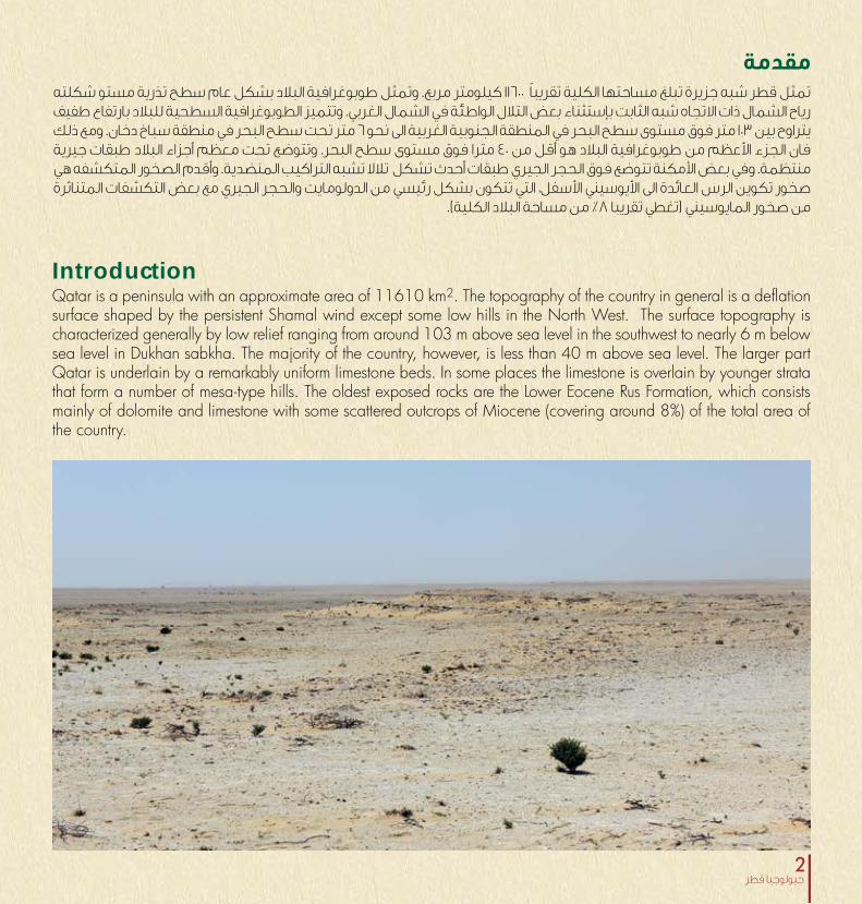
Introduction
مقدمةتمثل قطر شبه جزيرة تبلغ مساحتها الكلية تقريباً 11600 كيلومتر مربع. وتمثل طوبوغرافية البلاد بشكل عام سطح تذرية مستو شكلته رياح الشمال ذات الاتجاه شبه الثابت بإستثناء بعض التلال الواطئة في الشمال الغربي. وتتميز الطوبوغرافية السطحية للبلاد بارتفاع طفيف يتراوح بين 103 متر فوق مستوى سطح البحر في المنطقة الجنوبية الغربية الى نحو 6 متر تحت سطح البحر في منطقة سباخ دخان. ومع ذلك فان الجزء الأعظم من طوبوغرافية البلاد هو أقل من 40 مترا فوق مستوى سطح البحر. وتتوضع تحت معظم أجزاء البلاد طبقات جيرية منتظمة. وفي بعض الأمكنة تتوضع فوق الحجر الجيري طبقات أحدث تشكل تلالا تشبه التراكيب المنضدية. وأقدم الصخور المتكشفه هي صخور تكوين الرس العائدة الى الأيوسيني الأسفل، التي تتكون بشكل رئيسي من الدولومايت والحجر الجيري مع بعض التكشفات المتناثرة
من صخور المايوسيني )تغطي تقريبا 8% من مساحة البلاد الكلية(.
Qatar is a peninsula with an approximate area of 11610 km2. The topography of the country in general is a deflation surface shaped by the persistent Shamal wind except some low hills in the North West. The surface topography is characterized generally by low relief ranging from around 103 m above sea level in the southwest to nearly 6 m below sea level in Dukhan sabkha. The majority of the country, however, is less than 40 m above sea level. The larger part Qatar is underlain by a remarkably uniform limestone beds. In some places the limestone is overlain by younger strata that form a number of mesa-type hills. The oldest exposed rocks are the Lower Eocene Rus Formation, which consists mainly of dolomite and limestone with some scattered outcrops of Miocene (covering around 8%) of the total area of the country.

3Geology of Qatar

4جيولوجيا قطر

5Geology of Qatar
Structural configuration The Arabian plate is formed of two major tectonic units; the Arabian Shield and the Arabian Platform. Although the Arabian Shield is an isolated craton made up of a complex igneous and metamorphic rocks but it affected significantly the geologic history of Qatar. Qatar is located in the stable shelf of the Arabian Plate, with few local tectonic features. The Arabian Shelf, including Qatar, was occupied by eastward deepening basin during most of the Phanerozoic accumulating more than 14 km of sediments.The whole country is considered to be situated on the broad part of the interior platform of the Arabian Shelf forming a part of a regional NNE-SSW trending high (the Qatar-South Fars Arch). Towards the north of the country, the Qatar Arch is bounded by the Zagros Fold Belt. A very broad N-S elliptic-shaped anticline forms the major parts of the country exposing the Middle Eocene Upper Dammam Formation. In the western side of the country, tighter NNW-SSE trending folds are formed such as Dukhan anticline and Zekrit and Salwa synclines. The Dukhan anticline exposed the older lower Dammam and Rus formations to the surface. The domal structure is around 80 km long, of which the northern 50 km are oil productive, and with average width of about 4.5 km. Younger Tertiary sediments belonging to the Miocene and Pliocene Dam and Hofuf formations crop out in the form of mesas that survived the wind erosion in some parts of synclinal regions on both sides of the southern extensions of Dukhan anticline, and unconformably overlies its flanks. These mesas consist mainly of carbonate, marl, clay and gypsiferous rocks of the Dam Formation and surmounted by conglomerates and clastic materials of the Hofuf Formation. They form the only conspicuous relief features in the southern and southwestern part of the country, where relatively thick sections of the Dam and Hofuf formations were reported in the Gulf of Salwa) with extensive outcrops occurring further to the west along the eastern coast of Saudi Arabia.
الجيولوجيا التركيبيةتتكون الصفيحة العربية من وحدتين بنيويتين )حركتيين( هما الدرع العربي والمنصة العربية. ورغم أن الدرع العربي هو راسخ منعزل مكون من خليط معقد من الصخور النارية والمتحولة غير أنه أثر كثيرا في التاريخ الجيولوجي لدولة قطر. تقع قطر على الجرف المستقر من الصفيحة العربية فضلا عن بعض المظاهر الحركية المحلية القليلة. وكان الجرف العربي وبضمنه قطرا جزءا من بحر يزداد عمقا صوب الشرق خلال
معظم حقبة الحياة الظاهرة حيث تراكم فيه ما يزيد على 14 كيلومتر من الترسبات.ويفترض أن معظم أجزاء البلاد تقع على الجزء الواسع من المنصة الداخلية للجرف العربي مشكلة جزءا من مرتفع اقليمي ذي اتجاه شمال شمال غرب الى جنوب جنوب شرق )وهو ما يطلق عليه قوس قطر جنوب فارس(. وبإتجاه شمال البلاد يتحدد قوس قطر بنطاق طيات زاجروس. وثمة طية واسعة بيضوية الشكل تمتد من الشمال نحو الجنوب تشكل معظم أجزاء البلاد كاشفة صخور تكوين الدمام العلوي التي تعود الى الإيوسيني الوسيط. أما في الجانب الغربي من البلاد، فثمة طيات أضيق تتجه من الشمال الشمال الغربي الى الجنوب والجنوب شرق من أمثال طية دخان ومنخفضات زكريت وسلوى. وتكشف طية دخان المحدبة تكوينات الدمام الأسفل والرس الأقدم وتظهرها على السطح. ويبلغ طول التركيب المقبب نحو 80 كيلومتر تكون الخمسين الشمالية منها منتجة للنفط ويبلغ معدل عرض التركيب نحو 4,5 كيلومتر. وتتكشف صخور أحدث من العصر الثلاثي تعود الى تكويني الدام والهفوف من عصري الميوسيني والبليوسيني على هيئة مناضد قاومت تعرية الرياح في بعض مناطق المنخفضات على جانبي الامتدادات الجنوبية لطية دخان المحدبة وتتواضع على نحو غير متوافق على جناحيه. تتكون هذه المناضد من الصخور الجيرية والمارل والطين والصخور الجبسية العائدة لتكوين الدام وهي محاطة بحجر حصوي ومواد فتاتية تعود لتكوين الهفوف. وتشكل هذه المظاهر الطوبوغرافية الوحيدة الظاهرة للعيان في الأجزاء الجنوبية والجنوبية الغربية من البلاد حيث تم العثور على مقاطع سميكة نسبية من تكويني الدام والهفوف في خليج سلوى مع تكشفات واسعة تحدث الى الغرب على امتداد
السواحل الشرقية للملكة العربية السعودية.

6جيولوجيا قطر
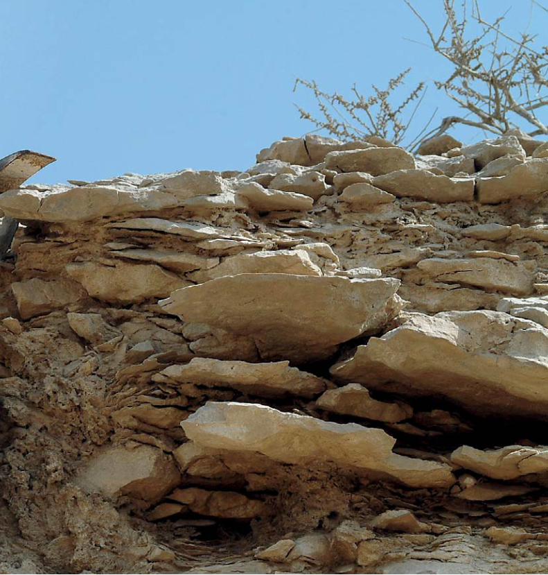
PhysiographyThere are several classifications for the physiographic features of Qatar. The most detailed among them is that of Ashour 1987 which will be summarized here. He classified these features into eight groups. These are:Hamada Plain sedimentsSurface sediments of the Hamada are usually formed of relatively angular, coarse-grained clastic materials that are derived from the underlying rocks with minimum transportation. The Arabic root Hamad means nice or blessed and so probably this part of the desert is better compared to the fully sandy part because the hamad plain may contain scattered plants and some ephemeral water sources. Exfoliation, i.e. peeling of the rock surfaces by weathering is the main mechanism for their formation which eventually would lead to the formation of stone pavement. Most of the clastic materials are formed of limestone and dolomitic and silicified limestone.
التضاريس
ترسبات سهول الحماد
قطر. تضاريس لوصف المستعملة التصنيفات من العديد هنالك 1987 عام عاشور نشره الذي التصنيف هو تفصيلا أكثرها ولعل بتقسيم قام إذ السطور. هذه في باستعراضه نقوم سوف والذي
هذه التضاريس الى ثمان مجموعات وهي:
خشنة فتاتية مواد من عادة السطحية الحماد ترسبات تتكون لها يتوفر أن دون التحتية الصخور تعرية من تنتج مزواة الحبيبات الحمد هو الحماد لكلمة العربي والجذر طويلة. لمسافة تنتقل أن الجزء هذا أن يعني مما اللطيف تعني التي الحميد أو الشكر وتعني الحماد قد الرملي لأن سهل من الصحراء هو أفضل مقارنة بالجزء يحتوي على نباتات متناثرة وبعض الموارد المائية الموسمية. ويعد الرئيسية الآلية هي بالتجوية الصخور سطوح تقشير أي التقشر، تتكون الصخرية. الأرصفة الى تكوين النهاية لتكونها مما يؤدي في معظم المواد الفتاتية من الحجر الجيري والحجر الدولوميتي والحجر
الجيري السليكي.

7Geology of Qatar
التراكمات الرمليةتقريباً 15% من العديد من الأشكال وتغطي الرملية التراكمات تتخذ المساحة السطحية لقطر. ومن أهم أنواع التراكمات الرملية ما يلي:
الفريش الرملي: الذي يتكون من ترسبات رملية أحدث عمرا ويمثل من تتكون وهي البلاد. في الرملية الكثبان لحقول الرمال مصدر صفائح رملية منبسطة مع بعض الكتل الرملية المتناثرة وترسبات منطقتين في التطور جيدة الترسبات وهذه فضالية. حصوية وتبلغ البلاد من الشرقي الشمالي الجزء في الأولى رئيسيتين
مساحتها زهاء 200 كيلومتر مربع والثانية الى الشرق من تلال دخان.
تم رملية ترسبات النبخات تمثل المثبتة(: )الكثبان النبخات منطقة في الترسبات هذه وتوجد النباتي. الغطاء بواسطة ثبيتها العادة من حجر زكريت وعلى حافات بعض السباخ. وهي تتكون في
رملي ناعم جيد الفرز ونادرا ما يتجاوز ارتفاعها الخمسين سنتمترا.
الكثبان الرملية: تعد الكثبان الرملية أكثر أنواع التراكمات الرملية الكثبان ولكن منعزلة كثبانا يكون وبعضها البلاد. في شيوعا الأخرى قد تشكل حقولا. ويمكن العثور على حقول الكثبان الرملية البلاد 10% من مساحة نحو الشرقية مغطية الجنوبية المنطقة في
وكذلك في المناطق الشمالية الغربية.
Sand accumulation takes many different forms and cover around 15% of the surface area of Qatar. The major sand landforms are:Sand sheets which are relatively more recent sediments and they form the source of sand dune fields of the country. They are formed of flat-lying sheets with some patchy sand drifts and residual gravel deposits. They are well-developed in two areas, the first is in the northeastern part of the country with a total area of around 200 km2 and the second one is to the east of Dukhan hills. Nebkhas on other side are sand deposits that accumulate due to the baffling action of vegetation. There are reported from Zikrit area and on the margins of some sabkhas. They are formed of relatively well-sorted, fine sand and rarely exceed 50 cm in height. Sand dunes are the most prevalent form of sand accumulation in the country. Some of them are isolated individuals but barchans also occur containing longitudinal are reverse dunes. Sand dune fields can be found in the southeast covering around 10% of the total area of the country as well as in the southwestern areas.
Sand accumulation

8جيولوجيا قطر
Depression soil (Rauda)
Duricrusts
Rauda soil is accumulation of relatively thick sediments in shallow depressions that punctuate the topography and believed to be the result of surface water erosional-depositional effects as it gets localized changing from sheet flow to small, short-living channels after heavy rain. The term Rauda means garden to indicate the flowering plants that flourish at such local, relatively thick and fertile soil during the short rainy season.
Duricrusts is a collective term to indicate all the sediments that are deposited from the upward movement of groundwater. Under arid climate, surface sediment moisture is lost by evaporation. If the groundwater is near to the surface as it is the case in Qatar, groundwater will move upward to compensate for the lost water content by capillary action. During their upward movement, groundwater becomes concentrated and starts to deposits minerals along their paths. Some of the deposited materials will break the soil others bind them together forming duricrusts. The mineralogy of duricrusts depends on the chemistry of the groundwater. Calcrete (calcite), dolocrete (dolomite), silicrete (silica) and ferrocrete (iron oxides) are examples of such sediments. A grey calcareous duricrusts were reported from Zikrit hills, which still cap some of the hills.
تربة المنخفضات )الروضات(
القشور الصخرية
في نسبيا سميكة ترسبات تراكم من الروضات ترب تتكون أنها ويعتقد الدولة تضاريس في تنتشر التي ضحلة منخفضات أن تنحصر السطحية بعد المياه التي تحدثها التعرية تترسب بفعل الأعمار قصيرة صغيرة قنوات الى الصفيحي الانسياب من متحولة الغناء الحديقة الروضة كلمة وتعني الغزيرة. الأمطار هطول بعد التربة هذه مثل في تزدهر التي المزهرة النباتات على للدلالة
الموضعية الخصبة السميكة نسبيا أثناء موسم الأمطار القصير.
القشور الصخرية مصطلح جمعي يدلل على كل الترسبات التي تنتج تفقد القاحلة المناخات ففي الأعلى. نحو الجوفية المياه حركة من الترب السطحية رطوبتها بواسطة التبخر، فإذا كانت المياه الجوفية سوف الجوفية المياه فأن قطر، في الحال كما السطح من قريبة الخاصية بفعل المفقودة المياه عن للتعويض الأعلى نحو تتحرك الجوفية المياه تصبح الأعلى صوب الحركة هذه وخلال الشعرية. تقوم مسارها. امتداد على المعادن بترسيب وتبدأ تركيزا أكثر بعض المواد المترسبة بكسر التربة في حين تقوم بعض الترسبات وتعتمد الصخرية. بالقشور يسمى ما مكونة بعضها مع بربطها فهنالك الجوفية المياه كيمياء على الصخرية القشور معدنية القشور الجيرية أو الدولوميتية أو السليكيه أو الحديدية. ولقد وصفت قشور صخرية جيرية من تلال زكريت التي تتخذ شكل قبعات تغطي
التلال الموجودة هناك.

9Geology of Qatar
Fluvial sediments
Fluvial sediments are those laid down by surface waters. They are divided according to their age into two groups; the pre-Pleistocene deposits and the Recent Wadi sediments. The pre-Pleistocene sediments consists of around 12m of gravel, sand and silt and found mainly in the southwestern areas of Qatar and thought to be transported to Qatar by a major river system sourced in Saudi Arabia. Recent Wadi sediments are formed mainly of gravel that is believed to be eroded from the Hofuf Formation. These are of limited distribution indicating limited fluvial processes in modern times.
الترسبات النهريةمن الترسيب بواسطة النهرية الترسبات تتكون الأسم، يدلل كما المياه السطحية. وهي تقسم اعتمادا على عمرها الى مجموعتين: الحديثة. الوديان وترسبات الجليدي العصر قبل ما ترسبات تتكون ترسبات ما قبل العصر الجليدي من نحو 12 مترا من الحصى والرمل والغرين، وتوجد بشكل رئيسي في المناطق الجنوبية الغربية رئيسية أنهار بواسطة قطر الى نقلت قد بأنها ويعتقد قطر، من الحديثة الوديان ترسبات أما السعودية. الأراضي من تنبع كانت فهي تتكون بشكل رئيسي من تعرية تكوين الهفوف. وتكون هذه في النهرية العمليات محدودية على يدلل مما الانتشار محدودة
الأزمنة الحديثة.

10جيولوجيا قطر
Sabkhas
Umm Said sabkha is one of the first studied sabkhas in the region. The usual supratidal zone changes gradually into well-developed microbial mat belt in the upper intertidal zone with some mangrove stands.
Dukhan sabkha is more like a salina rather than typical sabkha. It consists of a 130 km2 depression and ranges in elevation between 1.8 m above sea level and 3 m below it. Most of the area is covered with thin crust of salt (5-10 cm) and sometimes with a mixture of clastic sediments and salt crystals that formed in the intervening spaces by direct evaporation.
السباخبسبب وذلك القطن ندف الأصل في تعني عربية كلمة السبخة مقارنة الصيف فصل خلال سطحها تغطي التي الملحية الطبقة عادة. بها تحيط التي الفاتحة البنية أو الصفراء الرملية بالكثبان المغطاة المنبسطة الأرض لتعني العالمية المعاجم الى ودخلت القاحلة المناطق في تتكون مائية أنظمة هي والسباخ بالملح. الجبس مثل تبخرية معادن بوجود وتتميز الجافة، المناخات ذات
والأنهيدرايت والملح. وهنالك سبختان مهمتان في قطر وهما:
المنطقة. في دُرست التي السباخ أول من وهي مسيعيد: سبخة الى التبخرية بالمعادن المغطى المدي فوق النطاق فيها ويتحول نطاق مغطى بمنبسط أحيائي في النطاق بين المدي كما أن هنالك
بعض المناطق المغطاة بأشجار القرم )المنجروف(.
كونها من ملحي مستنقع الى اقرب السبخة هذه دخان: سبخة 130 نحو مساحته تبلغ منخفض من تتكون وهي اعتيادية. سبخة البحر مستوى فوق متر 1,8 بين الإرتفاع في وتتراوح مربع كيلومتر الملح من رقيقة بقشرة مغطى المنطقة ومعظم تحته. متر 3 و مغطاة تكون الأحيان بعض وفي سم( 10-5 بين سمكها )يتراوح بخليط من الترسبات الفتاتية وبلورات الملح التي تتكون في الفراغات
الموجودة بينها بفعل التبخر المباشر.
The Arabic word sabkha means salt-encrusted flat land. The original word means cotton flock because sabkhas usually appear white in the horizon compared to the yellowish brown colored deserts. Sabkhas are hydrological regimes developed under arid climatic conditions with shallow water table and characterized by the presence of evaporate minerals such as gypsum, anhydrite and halite. There are two main sabkhas in Qatar. These are:

11Geology of Qatar


14جيولوجيا قطر

15Geology of Qatar
الترسبات الساحليةالترسبات الساحلية هي تلك الترسبات التي ترتبط بالبيئة البحرية الضحلة وتنتج من التأثيرات المترابطة للترسيب والتعرية.وتقسم عادة الى
الأقسام التالية:منبسطات المد: تمثل منبسطات المد المناطق التي تغطيها مياه البحر أثناء المد العالي وتتراجع عنها أثناء المد الواطئ. وهي تتراوح في العرض من بضعة أمتار الى عدة كيلومترات اعتمادا على مقدار المد والطوبوغرافية المحلية. وتتميز هذه المناطق بوجود منبسطات أحيائية وبساتين القرم )المنجروف(. وتتكون ترسباتها عادة من الرمل الجيري والغرين والطين ذي الأصل الكيميائي أو الكيميائي الأحيائي مع بعض
الكائنات الحية اعتمادا على نسبة ملوحة المياه.النطاق تحت المدي: يمثل النطاق تحت المدي ذلك الجزء من البيئة البحرية الذي يكون مغطى بالمياه طوال الوقت. وتتكون الترسبات فيه بشكل رئيسي من ترسبات جيرية بحجم الغرين والطين فضلا عن الحبيبات الهيكلية مثل كسارة الأصداف وقطع المرجان مع بعض تتاثر التي الرسوبية البيئات من واسعا مدى العربي الخليج في المدي تحت الناطق ويمثل والبلتات. الأوليتات مع الهيكلية غير الحبيبات
بالعوامل البرية في الكثير من الحالات.
Coastal sedimentsCoastal sediments are these sediments associated with the shallow marine environment and resulted from the combined effect of accumulation and erosion. Intertidal flats are the areas covered by seawater during high tide and exposed during the low tide. They range in width from few meters to several kilometers depending on the tidal range and local topography. They are characterized by the presence of microbial mats and mangrove stands. The sediments are formed of carbonate sand, silt and mud of either chemical or biochemical origin with some organisms depending on the salinity level.Subtidal zone is that part of the marine environment covered with water all the time. They are formed mainly of silt and clay-sized carbonate sediments with skeletal grains such as shell fragments and coral debris with non-skeletal grains such as ooliths and pellets. The subtidal zone of the Arabian Gulf is a complicated mixture of different sedimentary environments that are influenced by terrestrial factors in some cases.

16جيولوجيا قطر
الدحول )مظاهر الكارست(الدحول هي منخفضات أو مظاهر تهدم موجودة في العديد من المناطق السطحية في قطر. وتنتج الدحول من التأثير المشترك للعديد من العوامل مثل تاثير المياه والشد على أنواع مختلفة من الصخور ذات قدرات ذوبان وتحمل مختلفة. وتمثل الدحول مشاكل تقنية أرضية في
العديد من المناطق العمرانية والسكنية في البلاد.

17Geology of Qatar
Depressions and collapse features are common features in the surface topography of Qatar. They are the net result of the combined action of water and mechanical stress on different types of rocks with different coherence and solubility. They represent a serious geotechnical problem in many of the residential areas of the country.
Dohool (Karst features)

18جيولوجيا قطر

19Geology of Qatar
Surface GeologyThe surface geology of Qatar is covered by two contrasting lithological regimes; carbonates and clastics. The Miocene-Pliocene and Pleistocene strata are formed of clastic materials while the rest are formed of carbonate sediments and strata. The following is a short summary of the marine exposed formations forming the surface geology of the country.
الجيولوجيا السطحيةيغطى سطح دولة قطر بنوعين رئيسيين من الترسبات هما المواد الجيرية والفتاتية. وتتكون طبقات المايوسيني-البليوسيني والجليدي البحرية للتكوينات سريع عرض يلي وفيما جيرية. وطبقات ترسبات من الباقية البقية تتكون حين في فتاتية مواد من )البليستوسيني(
المتكشفة التي تشكل الجيولوجيا السطحية لدولة قطر.


22جيولوجيا قطر
Hofuf Formation (Late Miocene-Pleistocene)The Hofuf Formation represents the youngest Neogene deposits in the Qatar Peninsula and forms about 3% of the exposed rocks. The name is taken after the village of Hofuf in Saudi Arabia. The Hofuf Formation consists of three distinct facies: clast-supported conglomerate, coarse-grained sandstone, and fine-grained sandstone.
تكوين الهفوف )المايوسيني المتأخر-البليستوسيني(يمثل تكوين الهفوف أحدث ترسبات النيوجيني في دولة قطر ويشكل نحو 3% من مجموع الصخور المتكشفة فيها. والأسم مأخوذ من اسم قرية الهفوف في المملكة العربية السعودية. يتكون تكوين الهفوف من ثلاث وحدات متميزة هي: الحجر الحصوي وحجر رملي خشن
وحجر رملي ناعم.
23Geology of Qatar
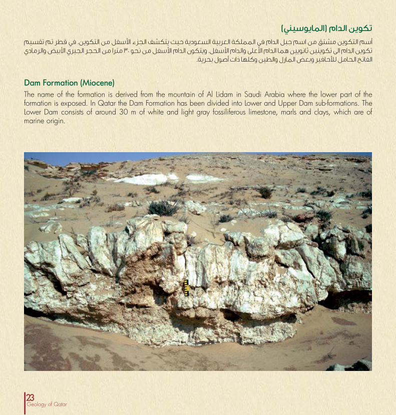
Dam Formation (Miocene)The name of the formation is derived from the mountain of Al Lidam in Saudi Arabia where the lower part of the formation is exposed. In Qatar the Dam Formation has been divided into Lower and Upper Dam sub-formations. The Lower Dam consists of around 30 m of white and light gray fossiliferous limestone, marls and clays, which are of marine origin.
تكوين الدام )المايوسيني(أسم التكوين مشتق من اسم جبل الدام في المملكة العربية السعودية حيث يتكشف الجزء الأسفل من التكوين. في قطر تم تقسيم تكوين الدام الى تكوينين ثانويين هما الدام الأعلى والدام الأسفل. ويتكون الدام الأسفل من نحو 30 مترا من الحجر الجيري الأبيض والرمادي
الفاتح الحامل للأحافير وبعض المارل والطين وكلها ذات أصول بحرية.

24جيولوجيا قطر
Dammam Formation (Lower-Middle Eocene)In Qatar, the formation is divided into upper and lower parts. Each part is divided into several members with different names by different authors. The most common nomenclature is that the Lower Dammam is divided into the Midra Shale and Dukhan members, while the Upper Dammam is divided into the Umm Bab (which is also called Simsima) and Abaruq members. The Midra Shale consists of gypsiferous shale with shark teeth, while the Dukhan member consists of large-foraminifera bearing limestone. The Umm Bab (Simsima) member covers most parts of Qatar and consists of neomorphosed chalky limestones, locally dolomitized or silicified. The Abaruq Member is formed of silicified dolomite and dolomitic marly limestones. This member is of local distribution only and found mainly in the low areas bordering Dukhan anticline and Zekrit area.
تكوين الدمام )الأيوسيني الأسفل – الأيوسيني الأوسط(يقسم التكوين في دولة قطر الى جزئين علوي وسفلي. ويقسم كل جزء إلى عدة أعضاء باسماء مختلفة من قبل كتاب مختلفين. ومن أكثر التسميات استعمالا هو تقسيم الدمام الأسفل الى عضوي مدره ودخان، في حين يقسم الدمام الأعلى الى عضو أم باب )ويسمى أيضا الدخان من بينما يتكون عضو القرش المدرة من سجيل جبسي مع بعض أسنان سمك أبرق. ويتكون سجيل السمسمة( وعضو عضو حجر جيري حامل للفورامنفيرا الكبيرة. ويغطي عضو أم باب )السمسمة( معظم أجزاء قطر ويتكون من حجر جيري معاد التبلور وقد يكون متدلمتا أو محتلا بالسليكا. ويتكون عضو الأبرق من دولومايت محتل بالسليكا وحجر جيري مارلي متدلمت. ويتميز هذا العضو بمحدودية
انتشاره ويوجد بشكل رئيسي في المناطق المنخفضة التي تجاور طية دخان المحدبة ومنطقة زكريت.

25Geology of Qatar
تكوين الرس )الإيوسيني الأسفل(اسم هذا التكوين مأخوذ أيضا من المقاطعة الشرقية من المملكة العربية السعودية. وفي قطر، يتكشف الجزء الأعلى من التكوين فقط حيث يتكشف نحو 25 مترا منه على مسافة كيلومتر واحد من محطات قطر للبترول في الفحاحيل في منطقة دخان. ويقسم التكوين الى عضوين هما الخور وترينة. ويتكون عضو الخور من نحو 25 كيلومتر من الحجر الجيري الطباشيري دقيق الحبيبات مع بعض المارل والطين في الجزء العلوي. ويتكون الجزء الأسفل من عضو ترينة من تبادل من المارل والحجر الجيري الدولوميتي، في حين يتكون الجزء العلوي من
حجر جيري خشن مع كرات طينية.
Rus Formation (Lower Eocene)The term is also derived from the eastern province of Saudi Arabia. In Qatar, only the upper part of the formation is exposed, where around 25 m of the formation are exposed at around 1 km from the Qatar Petroleum plants at Fhahil in Dukhan area. The formation is divided into two members namely Al Khor and Traina. Al Khor Member consists of around 25 m of fine-grained chalky limestone alternation with marl and clay at top. The Lower part of the Traina member consists of alternations of marls and dolomitic limestone, while the upper part is formed of coarse limestone with mud balls.

26جيولوجيا قطر
Water ResourcesAll fresh water in Qatar is coming from desalination plants and groundwater. The groundwater system of Qatar is that of Eastern Arabia and aquifers are found mainly in the Tertiary strata. Most of the groundwater are found in three aquifers. These are:
الموارد المائيةتأتي كل كميات المياه العذبة في دولة قطر أما من المياه الجوفية أو محطات التحلية. ونظام المياه الجوفية في قطر هو ذلك الموجود بشكل المائية الخزانات تتواجد حيث العربية الصفيحة شرق في رئيسي في طبقات العصر الثلاثي. وتوجد معظم المياه الجوفية في
ثلاثة خزانات هي:

27Geology of Qatar
Umm er Radhuma Aquifer (Paleocene)
The Rus Aquifer (Eocene)
The Umm er Radhuma Formation consists of 300-500 m of alternating limestones and dolomites. The top 30-50 m is characterized by the presence of karstic dolomite. The marl content of the formation increases downwards. This aquifer contains brackish water beneath the whole country.
The Rus Formation is formed of tight evaporitic zone ranging in thickness between 10-100m of anhydrite with marl and some thin limestones. This zone is overlain and underlain by a succession of around 10-20m composed of limestone, dolomite and some marl. The anhydrite facies represents an aquiclude, while the carbonate facies is important aquifer containing large reserves of freshwater, and is in hydraulic continuity with Umm er Radhuma formation below.
خزان الرس )الأيوسيني(
خزان أم الرضومة )الباليوسيني(
يتكون تكوين الرس من نطاق تبخري كثيف يتراوح في السمك بين الجيري الحجر طبقات وبعض المارل مع الأنهايدرايت من متر 100-10سمكه يتراوح تتابع وتحته التكوين فوق ويتوضع السمك. قليلة بين 10-20 متر من الحجر الجيري والدولومايت وبعض المارل. ويمثل الأنهايدرايت الطبقة العازلة في حين تمثل الصخور الجيرية خزانا مائيا اتصال على وهو العذبة المياه من كبيرة كميات على يحتوي هاما يتوضع الذي الرضومة أم خزان مع مائي( )حركي داينميكي هايدرو
تحته.
الجيري الحجر من متر 500-300 من الرضومه أم تكوين يتكون والدولومايت. وتتميز 30-50 متر العليا بوجود دولومايت كارستي )أي حاوي على التجاويف(. وتزداد كمية المارل في التكوين نحو الأسفل. والمالحة( العذبة المياه من )مزيج مجة مياه على الخزان ويحتوي
تحت معظم أنحاء البلاد.
Dammam Aquifer (Eocene)
The lower Dammam Formation consists of about 12m of compact, fossiliferous, chalky limestone with laminated fossiliferous shale. This shale unit has confined the Rus groundwater. The absence of shale from northern Qatar has great recharge significance and represents a controlling factor in the solution of gypsum from the underlying Rus Formation. The Upper Dammam ranges in thickness between 10-65m and composed of dolomitic limestone, it is an important artesian aquifer in southwestern Qatar only, but unimportant elsewhere. The Dammam aquifer is connected to the Umm er Radhuma aquifer, and contains old water (10,000 to 17,000 years).
خزان الدمام )الأيوسيني(يتكون جزء تكوين الدمام الأسفل من نحو 12 متر من الحجر الجيري المصمت الحامل للأحافير مع رقاقات من السجيل الحامل للأحافير. وقد حصرت وحدة السجيل مياه الرس الجوفية.. أن غياب السجيل في شمال قطر له أهمية عالية في إعادة تغذية الخزان ويمثل عامل مؤثر في ذوبان الجبس في تكوين الرس الذي يتوضع تحته. أما جزء تكوين الدمام الأعلى فيتراوح في السمك بين 1-65 متر وهو يتكون المنطقة في مهما ارتوازيا خزانا ويمثل دولوميتي، جيري حجر من في تذكر أهمية له ليس ولكن فقط البلاد من الغربية الجنوبية الرضومة أم خزان مع اتصال على الدمام وخزان الأخرى. المناطق
ويحتوي على مياه قديمة )يتراوح عمرها بين 10000 الى 17000 سنة(.

28جيولوجيا قطر
Hydrocarbon ResourcesThe search for oil in Qatar started in 1937. At that time, the accepted conception is that hills represent the best places to look for oil, and so the long, narrow anticline of Dukhan was selected as the best available option. In October 1938, well Dukhan-1 was drilled and became the first discovery well after reaching a depth of 1,777 m in January 1940. Production started at Dukhan field in 1947 and the first shipment of its oil was exported in December 1949. Oil was found in the Jurassic Qatar Formation (equivalent to the Arab Formation in Saudi Arabia). Subsequently, oil was discovered also in the Middle Jurassic Uwainat Member of the Araej Formation. Gas was found in the Permian Khuff Formation.
الموارد النفطيةبدأ البحث عن النفط عام 1937. وفي ذلك الوقت كانت الفكرة المقبولة بين المختصين أن التلال تمثل أفضل الأماكن لتواجد النفط، لذلك تم اختيار طية دخان الطولية الضيقة باعتبارها الخيار الأفضل. وفي أكتوبر )تشرين الأول( من عام 1938 حفرت البئر الأولى دخان 1 وأصبحت الإكتشاف النفطي الأول بعد أن وصلت الى عمق 1777 متر في يناير )كانون الثاني( عام 1940. وعثر على النفط في تكوين قطر الجوراسي )الذي الجوراسي من العريج تكوين من العوينات عضو في كذلك النفط اكتشف ولاحقا السعودية(. العربية المملكة في العرب تكوين يكافئ
الوسيط ، كما عثر على الغاز في تكوين الخف من العصر البرمي.

29Geology of Qatar

30جيولوجيا قطر
Main reservoir rocks
Tabuk Formation (Ordovician)
Sharawra Formation (Silurian)
Tawil Formation (Lower Devonian)
Haushi Formation (Lower Permian)
Reservoir rocks are these rocks that have the capacity to store hydrocarbons in them due, among other properties, to their porosity (i.e. the percentage of voids between their grains) and permeability (their ability to allow oil and gas to pass through them through the connected pores). The most important reservoir rocks in Qatar arranged from the older ones are:
Tabuk Formation has been drilled only in few wells in Qatar. It consists of partially dissolved sandstone with some moldic porosity which is around 10% with a permeability of less than 1 md. The formation is found to contain gas in well Matbakh-2.
The Sharawra Formation is composed of fine- to coarse-grained sandstone with solution porosity. It has a moderate reservoir potential and also has some gas in well Matbakh-2.
The Lower Devonian Tawil Formation is made up of sandstone with porosity values that range between 7-24% and a permeability that may reach 4000 md. The formation has good reservoir characteristics and was found to be gas-bearing in well Matbakh-2.
The Haushi Formation is formed of sandstone and shale with intergranular and moldic porosity. The porosity values are between 3 -18%, with permeability that ranges from less than 1 to 3000 md. The formation is gas-bearing in wells of Ras Qirtas-1 and Matbakh-2 wells.
المكامن النفطية الرئيسية
تكوين تبوك )الأوردوفيشي(
تكوين شارورة )السيلوري(
تكوين الطويل )الديفوني الأسفل(
تكوين الحوشي )البرمي الأسفل(
تعُرف المكامن النفطية بأنها تلك الصخور التي لها على القدرة على خزن الهايدروكربونات وذلك بسبب، من بين عوامل أخرى، مساميتها ونفوذيتها الحبيبات( بين الموجودة للفراغات المئوية النسبة )أي مساماتها خلال من بالمرور والغاز للنفط السماح على قدرتها )أي المتصلة مع بعضها(. أن أهم المكامن النفطية الموجودة في قطر
مرتبة من الأقدم الى الأحدث هي:
تم حفر تكوين تبوك في عدد محدود من الآبار فقط، وهو يتكون من التي القالبية المسامية بعض مع جزئي لذوبان متعرض رملي حجر تبلغ نحو 10% مع نفوذية لا تتجاوز 1 ملي دارسي. ولقد وجد أن التكوين
يحتوي على الغاز في بئر مطبخ-2.
الناعم من الحجم في يتراوح رملي حجر من التكوين هذا يتكون مكمنية مواصفات له ذوبانية. مسامية مع الحبيبات خشن الى
متوسطة واحتوى على بعض الغاز أيضا في بئر مطبخ-2.
يتكون تكوين الطويل من الديفوني الأسفل من حجر رملي مع قيم دارسي. ملي 4000 الى تصل قد ونفوذية %24-7 بين تتراوح مسامية للتكوين مواصفات مكمنية جيدة ووجد أنه يحتوي على الغاز في بئر
مطبخ-2.
الحجر من تبادل من الحوشي لتكوين الصخاري التكوين يتسم الرملي والسجيل مع مسامية بينية وقالبية. وتتراوح قيم المسامية بين 3-18% مع قيم نفوذية تتراوح بين اقل من واحد و 3000 ملي دارسي.
التكوين حامل للغاز في آبار راس قرطاس أ و مطبخ-2.

31Geology of Qatar

32جيولوجيا قطر
Khuff Formation (Upper Permian)
Araej Formation (Middle Jurassic)
The Upper Permian Khuff Formation is the main gas reservoir in the North Field and has important reserve in Dukhan Field. It is the main gas reserve all over the Eastern Arabian Plate including Iran. The Formation consists of dolomitized, bioclastic limestone, dolomite and anhydrites. It is characterized by the presence of moldic, intergranular and intercrystalline porosities where porosity exceeds 30%, with permeability around 3000 md.
This formation has important oil reserves in the fields of Dukhan, Bul Hanine, Maydan Mahzam and Idd El Shargi. The middle limestone unit of the formation is the main reservoir and it is called the Uwainat limestone reservoir. This unit has a considerable porosity but the permeability is generally rather poor. For example, in the Dukhan Field, the average porosity of the unit is around 18% but its permeability is only 15 md. In the Idd el Shargi North Dome, the reservoir has porosity values that range between 5-20% with permeability of 1-1600 md. In the Maydan Mahzam and Bul Hanine fields, the porosity and permeability values for the Uwainat reservoir are 10-23% and 2-300 md and 5-21% and 500 md, respectively.
تكوين الخف )البرمي الأعلى(
تكوين العريج )الجوراسي الأوسط(
الشمال حقل في الرئيسي الغازي المكمن الخف تكوين يمثل أن والحقيقة ايضا. دخان حقل في هامة احتياطات على ويحتوي الشرقية الأجزاء أنحاء كل في الرئيسي الغازي المكمن هو الخف من الصفيحة العربية وإيران. وهو يتكون من حجر جيري فتاتي أحيائي بوجود المكمن هذا يتميز وأنهايدرايت. دولومايت مع متدلمت مع %30 أحيانا تتجاوز مسامية وله وبلورية وبينية قالبية مسامية
نفوذية قد تصل الى 3000 ملي دارسي.
يحتوي التكوين على احتياطيات نفطية مهمة في حقول دخان وأبو الجيري الحجر وحدة وتمثل الشرقي. والعد محزم وميدان الحنين مكمن وتسمى فيه الرئيسي المكمن التكوين من الوسطى النفوذية ولكن متوسطة مسامية وللوحدة الجيري. العوينات واطئة بشكل عام. فعلى سبيل المثال يبلغ معدل مسامية الوحدة في حقل دخان نحو 18% ولكن نفوذيته أقل من 15 ملي دارسي. وفي القبة الشمالية من حقل العد الشرقي يحتوي المكمن على مسامية تتراوح بين 5-20% مع نفوذية تتراوح بين 1-1600 ملي دارسي. وفي حقلي ميدان محزم وأبو الحنين، تتراوح مسامية مكمن العوينات بين 10-
500 ملي النفوذية بين 2-300 ملي دارسي و 5-12% و 23% بينما تتراوح دارسي على التتابع.
Shuaiba Formation (Aptian)The Shuaiba Formation is one of the most important oil reservoirs in the Arabian Plate. In Qatar it was found to contain oil in the Idd El Shargi North Dome. Large part of the formation is made up of rudist fragments and chalky limestone. The porosity values of the formation range between 6-25% and permeability values that may reach 50 md.
تكوين الشعيبة )الأبتي(يعد تكوين الشعيبة أحد أهم المكامن النفطية في الصفيحة العربية. من الشمالية القبة في النفط على التكوين يحتوي قطر دولة وفي حقل العد الشرقي. ويتكون الجزء الأعظم من التكوين من كسارة أصداف الرودست والحجر الجيري الطباشيري. تتراوح قيم المسامية
بين 6-25% وقد تصل النفوذية الى نحو 50 ملي دارسي.

33Geology of Qatar
Arab Formation (Upper Jurassic)
Mauddud Formation (Albian)
The Upper Jurassic Arab Formation (Also called the Qatar Formation) is the main carbonate reservoir in the southern parts of the Arabian Basin. It hosts the largest oil reserves in the world including the major part of the Saudi reserve. The formation is made up of variable alternations of limestone, dolomite with some evaporites. The main porosity types are either intergranular in the oolitic limestone or intercrystalline in the dolomite reservoirs. Porosity is up to 30% were found in some horizons of the formation with permeability values of up to 500 md.
The Mauddud Formation which is an important reservoir rocks in many parts of the Arabian Basin represents only moderate to poor reservoir in the North Field. The formation is composed of limestone containing large benthic foraminifera with some rudist fragments and dolomite. The rudist-bearing limestone has porosity values that range between 12-24% with low permeability values that range between 0.1-70 md.
تكوين العرب )الجوراسي الأعلى(
تكوين المودود )الألبي(
يمثل تكوين العرب من الجوراسي الأعلى )يسمى ايضا بتكوين قطر( العربي. الحوض من الجنوبية الأجزاء في الرئيسي الجيري المكمن وهو يحتوي على أكبر الإحتياطيات النفطية في العالم بضمنها الجزء الأساسي من الإحتياطي السعودي. ويتكون هذا التكوين من تبادلات مختلفة من الحجر الجيري والدولومايت مع بعض المتبخرات. ومن في البينية المسامية هي المكمن في الرئيسية المسامية أنواع المكامن في البلورية المسامية أو )الأوليتي( السرئي الجيري الحجر أنطقة بعض في %30 تتجاوز مسامية على عثر ولقد الدولوميتية.
التكوين مع قيم نفوذية تتجاوز 500 ملي دارسي.
من العديد في هاما نفطيا مكمنا يعد الذي المودود تكوين يمثل حقل في فقير الى متوسطا نفطيا مكمنا العربي الحوض أجزاء فورامنفيرا على يحتوي جيري حجر من التكوين ويتشكل الشمال. قيم وتتراوح والدولومايت. الرودست كسارة مع كبيرة قاعية المسامية في الحجر الجيري الحامل للرودست بين 12-24% مع قيم
نفوذية واطئة تتراوح بين 0.1-70 ملي دارسي.

34جيولوجيا قطر
Oil and Gas FieldsSince the exploration started in Qatar in 1940 five important commercial oilfields were discovered in the country.
حقول النفط والغازمنذ بدء التنقيب عن النفط عام 1940 في قطر تم اكتشاف خمسة
حقول تجارية في البلاد.
This field was discovered in 1940 and started production in late 1949. The structure is a long, salt-induced anticline with a gentle, north-south trend with an overall teardrop shape. It is around 70 km (43.5 mi) long and from 4-6 km (2.5-3.7 mi) wide. The field is characterized by a low structural relief and was recognized by the surface expression of its Tertiary rocks. The structure is asymmetric, and has four culminations along strike at the level of the Jurassic Arab reservoirs. The deepest drilled well in the field until the end of 1990 was Dukhan DKG-27 with a total depth of 4,975 m (16,318 ft) and penetrated the Ordovician elastics. All the reservoirs are carbonate rocks and the field is producing from producing horizons in the Arab, Araej (Uwainat Member) and Khuff formation. The initial recoverable oil reserve is estimated at 2.3 billion barrels with a recoverable gas reserves exceed 1.2 TCF.
حقل دخان أكتشف هذا الحقل عام 1940 وبدأ الإنتاج عام 1949. ويمثل التركيب ميلان مع السطحي تحت الملح دفع بتأثير تكونت طولانية قبة طفيف باتجاه الشمال- الجنوب ويكون شكله العام شبيها بالدمعة. يبلغ طول التركيب زهاء 70 كيلومتر )43,5 ميل( ويتراوح عرضه بين واطئ تركيبي بارتفاع الحقل ويتميز ميل(. 3,7-2,5( كيلومتر 6-4وتم تمييزه من هيئة توزيع صخور العصر الثلاثي المتكشفة فوقه. وهو غير متناظر وله أربعة تقببات على امتداد مضرب التركيب عند في حفرت بئر أعمق وبلغت الجوراسية. العرب مكامن مستوى الحقل بنهاية عام 1990 وهي بئر دخان 27 عمقا كليا بلغ نحو 4975 مترا )16,318 قدما( واخترقت فتاتيات العصر الأوردوفيشي. ومعظم الجيرية وينتج الحقل النفطية في الحقل هي من الصخور المكامن من أنطقة في تكوين العرب والعريج )عضو العوينات( وتكوين الخف. ولقد قدر الاحتياطي المبدئي القابل للإستخراج نحو 2,3 مليار برميل
مع احتياطي غازي قابل للإستخراج يتجاوز 1,2 ترليون قدم مكعب.
Dukhan Field
The field is the oldest offshore field and it is composed of two faulted domes aligned in a north-south direction which is believed to be resulted from salt pillowing that was active since the Triassic. The field was discovered in May 1960, and started production in 1964 from the Shuaiba, Araej and Arab reservoirs.
حقل العد الشرقيقبتين من يتكون وهو البحرية الحقول أقدم الحقل هذا يمثل قد ذلك أن ويعتقد الشمال-الجنوب، باتجاه تصطفان متفلقتين الترياسي. العصر منذ بالتحرك بدأ الذي الملح لحركة نتيجة حدث أكتشف الحقل في مايو )أيار( 1960 وبدأ الإنتاج عام 1964 من تكوينات
الشعيبة والعريج والعرب.
Idd El Shargi Field
This field has a flat, domal structure about 8x5 km in size. It was discovered by Shell-Qatar in 1963 and started production in 1965. The main reservoir is in Arab D carbonates with porosity and permeability values that range between 12-13% and 5-400 md.
حقل ميدان محزمكيلومتر. 8x5 بأبعاد منبسط قبوي بتركيب التركيب هذا يتميز أكتشف الحقل من قبل شركة شل قطر عام 1963 وبدأ الإنتاج منه الذي الجيري العرب د الرئيسي فيه في النفطي عام 1965. والمكمن 400-5 بين تتراوح ونفوذية %13-12 بين تتراوح مسامية بقيم يتميز
ملي دارسي.
Maydan Mahzam Field

35Geology of Qatar

36جيولوجيا قطر
This represents a dome elongated in a north-south direction with dimensions of 8x16 km. The field was discovered in 1965 in the northwest part of the field by Abu Dhabi Marine Area (ADMA); however, the first development well was not drilled until 1971 after the demarcation of the marine boundary with Abu Dhabi in 1969 and production started in 1972 mainly from the Arab D carbonate reservoir. The original recoverable oil reserve is estimated at 680 million barrels.
حقل ابو الحنين يتكون هذا الحقل من قبة تمتد طوليا باتجاه الشمال-الجنوب مع الشمالي الجزء في 1965 عام الحقل أكتشف كيلومتر. 8x16 أبعاد )أدما( ولكن لم البحرية أبو ظبي البلاد من قبل منطقة الغربي من أبو ظبي الحدود مع 1971 بعد ترسيم الأولى حتى عام البئر يتم حفر عام 1969 وبدأ الإنتاج من الحقل عام 1972 من مكمن العرب د الجيري للإستخراج القابل الأصلي النفطي الاحتياطي ويقدر رئيسي. بشكل
بنحو 680 مليون برميل.
Bul Hanine Field
This field was discovered in 1964 with a total area of about 20 sq. km. It extends across the marine borderline between Qatar and Abu Dhabi and its production is divided between the two countries.
حقل البندقأكتشف هذا الحقل عام 1964 وتبلغ مساحته الكلية نحو 20 كيلومتر ويقسم ظبي وابو قطر بين البحرية الحدود عبر يمتد وهو مربع.
انتاجه بين البلدين.
Al Bandaq Field
This field was discovered by the French company Elf Aquitaine in 1991. In 1997, the daily production capacity at this field was about 10 thousand barrels.
حقل الخليجأكويتان ألف الفرنسية البترول شركة قبل من الحقل هذا أكتشف عام 1991. وفي عام 1997 بلغت طاقة الانتاج اليومي من الحقل زهاء
10 الآف برميل من النفط.
AlKhaleej Field
The field was discovered in 1971 by Shell Qatar and is considered to be the largest gas reservoir in the world, with proven reserves of more than 300 TCF and estimated total reserves of 500 TCF. The field is huge, gentle, dome-shaped anticline trending north-south 130 km long and 75 km wide with a total area of more than 6,000 sq km which is nearly equivalent to half the area of Qatar.The main reservoir of the field is the Permian Khuff Formation, from which gas and condensate are produced. The thickness of this formation is around 854 m (2800 ft), and consists of five reservoir units, K1-K5, separated by layers of anhydrite. The Khuff Formation is formed of a sequence of carbonate rock of limestone and dolomite.
حقل الشمالأكبر يعد وهو قطر شل شركة قبل من 1971 عام الحقل اكتشف 300 من أكثر يبلغ مثبت باحتياطي العالم في مكتشف غازي حقل ترليون 500 نحو يبلغ مقدر كلي احتياطي مع مكعب قدم ترليون تتجه الميل واطئة هائلة طية عن عبارة والحقل مكعب. قدم 75 وعرضه كيلومتر 130 زهاء طوله ويبلغ الشمال-الجنوب صوب مما مربع كيلومتر 6000 من أكثر الكلية مساحته وتتجاوز كيلومتر
يعادل تقريبا نصف مساحة البلاد الكلية.المكمن الرئيسي في الحقل هو تكوين الخف من العصر البرمي الذي متر 854 نحو التكوين هذا سمك يبلغ والمكثفات. الغاز منه ينتج عليها يطلق مكمنية وحدات خمس من يتكون وهو قدم( 2800(ويشكل الأنهايدرايت. من بطبقات بعضها عن وتُفصل ك1-ك5
تكوين الخف من تتابع من الحجر الجيري والدولومايت.
North Field

37Geology of Qatar
This field was discovered by Maersk in 1992 with an estimated reserve of about 780 million barrels of oil as in 2003. Production started in 1994 with an average daily production capacity of 30 thousand barrels a day. Horizontal well technology has been used since 1994, drilling wells up to 31,000 ft in length.
حقل الشاهينويبلغ 1992 عام ميرسك شركة قبل من الشاهين حقل أكتشف الاحتياطي المقدر بنحو 780 مليون برميل حسب تقديرات عام 2003. بدأ الإنتاج من الحقل عام 1994 وبطاقة انتاجية تبلغ 30 ألف برميل في اليوم. أستعملت تقنية الحفر الأفقي في الحقل منذ عام 1994 وذلك
لحفر آبار يصل طولها الى نحو 31,000 قدم.
Al Shaheen Field
This field was operated at the beginning by Wintershall Consortium with ARCO, and then BP as operators before Anadarko finally took over operation in 2002. Production from the field is expected to jump to 25 thousand barels per day.
حقل الريانطور هذا الحقل في البداية من قبل اتحاد شركات ونترشل مع أركو ثم قامت شركة النفط البريطانية بتشغيله قبل أن تستولي شركة الانتاج يقفز أن المتوقع ومن .2002 عام وذلك عملياته على أنداركو
من الحقل الى 25 الف برميل في اليوم.
Al Rayyan Field


المنسق العام: خالد البكري اليافعي )مدير قسم المعلومات(
المحتوى العلمي: أ.د. فاضل السعدوني ) أستاذ جيولوجيا البترول(
التصميم والتصوير العلمي: أحمد عبدالعزيز إبراهيم )أخصائي التصوير العلمي(
Coordinator:Khalid Al-Bakri AL-Yafei (Information Manager)
Design & Scientific Images:Ahmed Abdulaziz (Scientific Photography Specialist)
Scientific content by:Fahil N. Sadooni, Ph. D (Professor of Petroleum Geology)
Publication of The Environmental Studies Center 2014من إصدارات مركز الدراسات البيئية
E.S.Center P.O. Box 2713 Doha-Qatar Tel.+974 44033939 Fax:+974 44033940 E-mail: [email protected] مركز الدراسات البيئية-جامعة قطر
![Untitled-1 [] · 2019-09-23 · rasgas qdvc . projects doha-qatar . cooling list of ongoing projects 2. wakra stadium qatar university pearl qatar lpw pearl qatar bvs 56 pearl qatar](https://img.pdfslide.net/doc/110x75/5e53388898cc9834405de475/untitled-1-2019-09-23-rasgas-qdvc-projects-doha-qatar-cooling-list-of.jpg)