Embed Size (px)
Citation preview
GENERAL GEOLOGY ANI) PHYSICO-
CHEMICAL PROPERTIES OF SOIL FROM
SIPADAN ISLAND AND MABt1L ISLAND
BHAVANI POOPALAN
GEOLOGY PROGRAMME
SCHOOL OF SCIENCE AND TECHNOLOGY
UNIVERSITI MALAYSIA SABAH
PERPUSTAKAAM UNIVERSIT I MALM SIA SARAH
2005
PERPUSTAKAAN UMS
IIIfII. IIIVIIIV'lillll9
UMVERSITI MALAYSIA SABAH
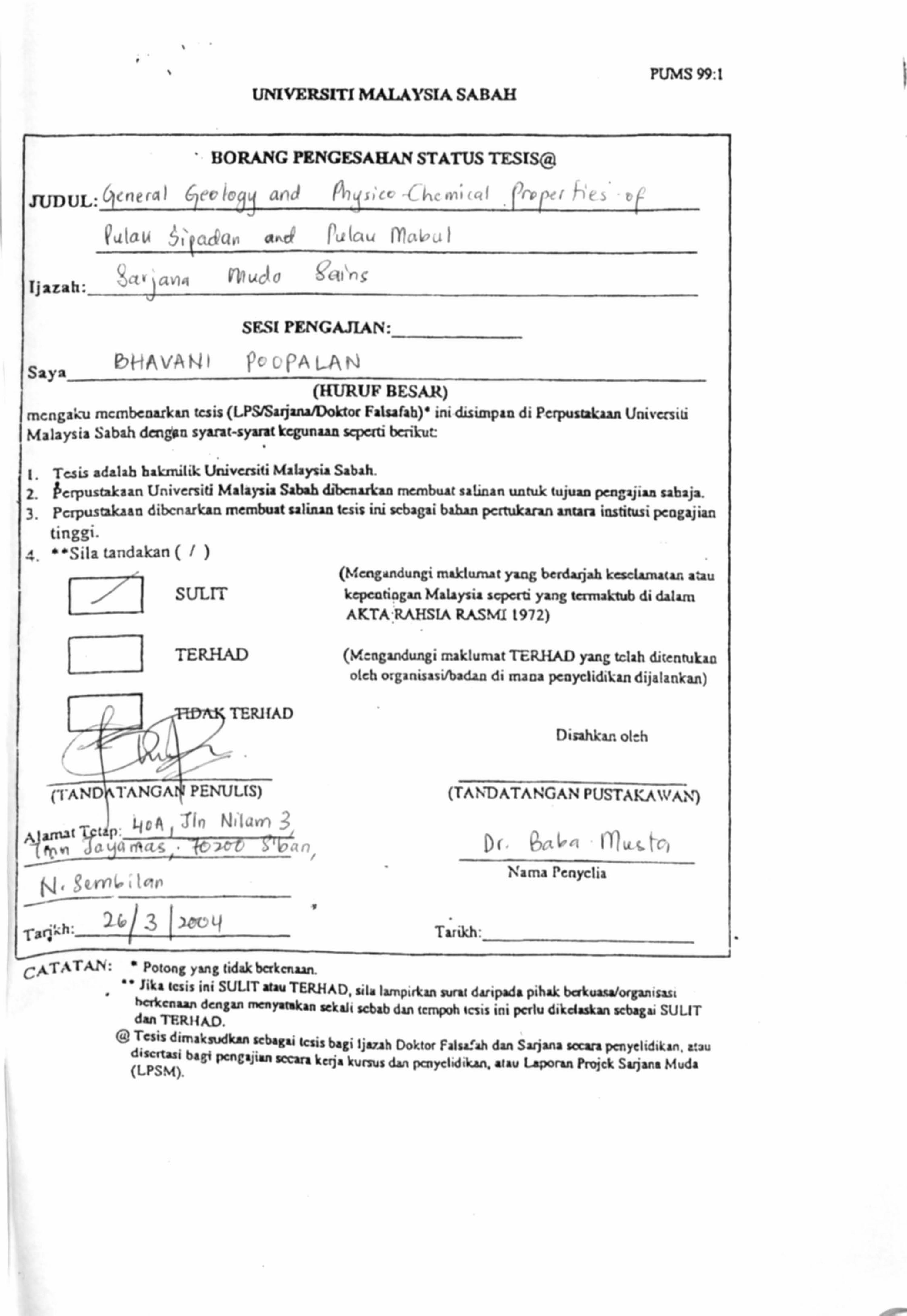
JUDUL: irlrral
tjlLah: __
BORANG PBNGESABAN STATUS TESIS, al
alau a,. ct ('ýlau Ir ,4ýI
4,7ý ýGiº1,1
r1uC10 ýcu'rS
SF-S[ PLNGAJIAN:
ý__. _ 6HA VA Ni }'c c. C, A L-A rv
Jaya
PUMS 99: 1
(HURUF BESAM)
mcngawv mcmbcnarkan tuis (LPS/Sarjuta/)oktor Falsafah)" ini disintpan di Perpusul'aan Univusiti
Malaysia Sabah dengtn syarat-syarat kcgunun scpctti bcrikut:
t, Tesis adalab hakmilik, Univctsiti Malaysia Sabah.
2. ýcrpustakaan Universiti Malaysia Sabah dibenukan rnembuat salinan untuk tujuan pengajian sahaja. 3, pcrpustakaan dibcnarkin membuat salinan tuis ini scbagai bahan pcrtukann anura institusi pcogajian
tinggi. ý. 0 "Sila tandakan (/)
Lk1 SULTT
TERHAD
(MScngrndungi makluniat yang berdarjah kesclarnuar, a tau kepcatiogan Malaysia scpcrti yang termak-wb di dalam AKTA RAHSIA RASM1 t972)
(Mcngandungi rraklumat TERHAD yang tclah ditentukan
olch organisasi/badan di maca peoyclidikan dijalankan)
Disahkan olth
(TAND\ITANGAJ PENULTS) (TAN'DATANGAN PUSTAKAWA\')
I 4cg Tin N'Ium -3 ý arýl ttp. 11 5' kt 1 1yamct; 0" z r,,, Ilýuýtýý
Nama Penyclia N. gemtý ý lgr
-T-
Ld-41q, k h26 3Tutkh:
CATAT, 1, N: " Potong yang tidakbakenaan.
. '" Jika tcsis ini SULZT atau TERHAD, silo lampirkan tarrat daripada pihak bakuaaa/organisui
I+akenaan dcngan menyatahan sekalt scbab clan tempvh tcsis ini pcrlu dikdaskan sebaaai SULIT din TF. RIIAD.
tu Tesis dimaksudkan scbagai tcsis bagi Ijauh Doktor Falsafah dan Satjana seam penyelidtkan. atau disertasi bagi pcngajian accara kerja kursus dan parycldikan, atau Laporan Proick Satjana Muda (LPSM).
M
J

II
DE('LARA'I'1ON
I hereby declare that this dissertation is based on my original work except for quotations
and citations which have been duly acknowledged. I also declare that it has not been
previously or concurrently submitted for any other degree at UMS or other institutions.
Date :
NS 2002-3972
VERIFICATION
1. SUPERVISOR
(DR. BABA MUS IA)
2. EXAMINER I
( PROF DR. SANUDIN IIJ. TAIIIR )
3. EXAMINER 2
(PROF. MADYA DR. SIiARIFF A. K. OMANG )
4. DEAN
Signature
III
(PROF. MADYA DR. AMRAN AIIMED )
IV'
A('KNOWLEGNlENT
I would like to thank my supervisor, Dr. ßaha Musta, who really helped and
guided me whenever I consulted him, even during his busiest hour he it here in Malaysia
or in Antartica.
Not forgetting too lecturers who willingly helped and guided not only to complete
this project, but shared their geological expertise throughout these three years of course.:
Prof Dr. Sanudin Tahir, Prof. Madya Dr. ShariflOmang, Prof. Dr. Felix Tongkul, En.
Adong Laming dan En. Sahat Sadikun. Special thanks to lab assistants, especially Encik
Jalaludin, En. Panjiman (SKIM). En. Mat and En Rahman.
Without friends, who am 1? Note of appreciation and many thanks to all who are
dearest to me: Bala, GP, Mala, Kanages, Punitha, Rani, the Magudianz: Kalis, Hari,
Vicky, Anand, Mog, Kitkat ,
Yugen, Zuraini, Am, Fizi and the rest of my coursemates
To my family, my father who always prays for me, my sister and brother who
never failed to support me in any way all the time
Lastly, to all those people who helped me to make it successfully so far, but
incase of my forgetting, thank you to you too.
ý
ABSTItA('T
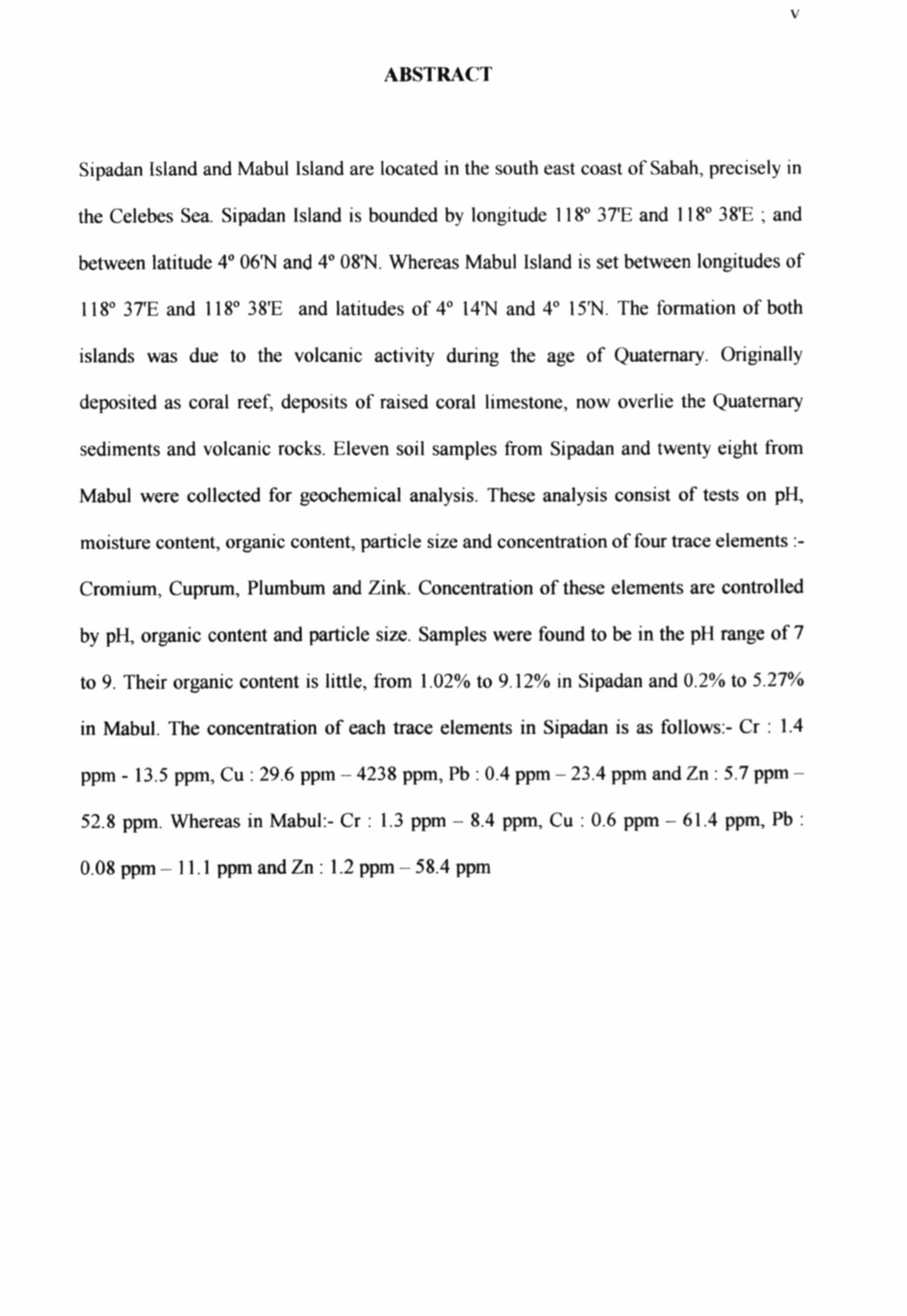
Sipadan Island and Mabul Island are located in the south east coast of Sabah, precisely in
the Celebes Sea. Sipadan Island is bounded by longitude 118° 3TE: and 118° 38'E: , and
between latitude 4° 06'N and 4° 08'N. Whereas Mabul Island is set between longitudes of
118° 3TE and 118° 38'E and latitudes of 4° 14'N and 4° 15'N. The formation of both
islands was due to the volcanic activity during the age of Quaternary. Originally
deposited as coral reef; deposits of raised coral limestone, now overlie the Quaternary
sediments and volcanic rocks. Eleven soil samples from Sipadan and twenty eight from
Mabul were collected for geochcmical analysis. These analysis consist of tests on pH,
moisture content, organic content, particle size and concentration of four trace elements : -
Cromium, Cuprum, Plumbum and Zink. Concentration of these elements are controlled
by pH, organic content and particle size. Samples were found to be in the p11 range of 7
to 9. Their organic content is little, from 1.02% to 9.12% in Sipadan and 0.2% to 5.27%
in Mabul. The concentration of each trace elements in Sipadan is as follows: - Cr : 1.4
ppm - 13.5 ppm, Cu : 29.6 ppm -- 4238 ppm, Pb : 0.4 ppm - 23.4 ppm and Zn : 5.7 ppm
52.8 ppm. Whereas in Mabul: - Cr : 1.3 ppm - 8.4 ppm, Cu : 0.6 ppm -- 61.4 ppm, Pb :
0.08 ppm 11.1 ppm and Zn : 1.2 ppm - 58.4 ppm
'i
ABti7'RAk
Pulau Sipadan dan Pulau Mahul terletak di hahagian pantai tenggara Sabah, iaitu di Laut
Celebes. Pulau Sipadan terletak di antara longitud 118° 37E dan 118° 38'1: ; dan di antara
latitud 4° 06'N and 4° O8'N. Manakala Pulau Mabul pula adalah di antara longitud 118°
3TE dan 118° 38'E: serta latitud 4° 14'N dan 4° 15'N. Pembentukan kcdua dua pulau
im dikailkan dengan aktiviti gunung berapi pada usia Kuatener. Karang batu kapur, yang
pada mulanya merupakan deposit hatu karang, kini terletak di atas sedimen Kuatemari
dan batuan volakanik. Sebelas sampel diambil dari Pulau Sipadan dan dua puluh lapan
lagi dari Pulau Mabul untuk dibuat analisa geokimia. Analisa-analisa yang dimaksudkan
adalah terhadap p11, kandungan kelembapan, kandungan organik, salz partikel tanah dan
kepekatan empat unsur surih, iaitu Kromium, Kuprum, Plumbum dan Zink. Kepekatan
unsur-unsur ini dipengaruhi oleh p1i, kandungan organik dan salz partikel. pH sampel-
sampel adalah dalam julat 7 9. Kandungan organik pula berjulat 1.02 °b - 9.12 % di
Sipadan dan 0.02 %-5.27 % di Mabul. Kepekatan unsur-unsur surih di Sipadan adalah
seperti berikut :- Cr : 1.4 ppm - 13.5 ppm, Cu : 29.6 ppm - 4238 ppm, Pb : 0.4 ppm
23.4 ppm and Zn : 5.7 ppm - 52.8 ppm. Manakala di Mabul :- Cr : 1.3 ppm - 8.4 ppm,
Cu : 0.6 ppm 61.4 ppm, Pb : 0.08 ppm 11.1 ppm and Zn : 1.2 ppm 58.4 ppm
vii
CONTENTS
PAGES
DECLARATION ii
VERIFICATION iii
ACKNOWLEDGEMENT iv
ABSTRACT V
ABSTRAK vi
LIST OF CONTENTS vii
LIST OF TABLES x
LIST OF FIGURES xi
LIST OF PHOTOGRAPHS xv
LIST OF MICROPHOTOGRAPHS xvi
CHAPTER 1 INTRODI'CTION I
1.1 LOCATION OF STUDY AREA I
1.2 OBJECTIVE 7
1.3 METHODOLOGY 7
1.3.1 Early Reseach and Literature Review 8
1.3.2 Fieldwork and Sampling 8
1.3.3 Laboratory Analysis 9
1.3.3 Report Writing 15
1.4 LITERATURE REVIEW 16
CHAPTER 2 GEOGRAPHY AND GEOMORPHOLOGY
2.1 INTRODUCTION
2.2 GEOGRAPHY OF THE STUDY AREA
2.2.1 Climate
2.2.2 Flora and Fauna
21
21
21
22
23
2.2.3 People 26
% 111
2.3 GEOMORPIIOLOGY 29
2.3.1 Topography and Drainage System
2.3.2 Geomorphological Evolution
2.3.3 Island Morphology
a. Sandy Beach
b. Coral Reef Zone
2.3.4 Mainland Morphology
a. Igneus Morphology
b. Sedimentary Morphology
30
34
35
35
39
41
42
44
CHAPTER 3 GENERAL GEOLOGY AND S'I'RA'TIGRAPIIY 47
3.1 INTRODUCTION 47
3.2 STRATIGRAPHY 48
3.3 REAGIONAL TECTONIC SETTING AND FORMATION 53
OF THE STUDY AREA
CHAPTER 4 GEOCHEMISTRY 57
4.1 INTRODUCTION 57
4.2 pH ANALYSIS 58
4.3 MOISTURE CONTENT ANALYSIS 60
4.4 ORGANIC CONTENT ( BOT %) 64
4.5 PARTICLE SIZE ANALYSIS 67
4.6 ANALYSIS OF TRACE EI. FMFNTS 81
4.6.1 AAS Results for Sipadan Island 82
4.6.2 AAS Results of Mabul Island 83
4.7 DISCUSSION 94
4.7.1 Introduction 94
4.7.2 Organic Content's (BOT%) Relation with pH 94
4.7.3 Relation between Percentage of Clay with Moisture Content 96
4.7.4 Relation of Trace Element's Concentration with Organic Content 98

ix
4.7.5 Relation of Trace Elements' Concentration with pH 103
4.7.6 Relation of Trace Elements' with Percentage of Clay 108
('HAPTER 5 CONCLUSION AND PROPOSAL 113
5.1 CONCLUSION 113
5.2 PROPOSAL 115
REFERENCE
APPENDIX
116
119
x
LIST OF TABLES
Table 2.1 : Ethnics in Semporna Island
Table 4. I: pH analysis for Sipadan Island
Table 4.2 : pH analysis for Mabul Island
Table 4.3 : Moisture content analysis for Sipadan Island
Table 4.4 : Moisture content analysis for Mabul Island
Table 4.5 : °'o of BOT in Sipadan
'f'able 4.6 °o of 13(Yf in Mabul
Table 4.7 : Distribution of particle size for Sipadan Island
Table 4.8 Distribution of particle size for Mabul Island
Table 4.9 : Concentration of trace elements in Sipadan Island
Table 4.10 Concentration of trace elements in Mabul Island
\1
LIST OF FIGURES
Figure 1.1
Figure 1.2
Figure 1.3
Figure 1.4
Figure 1.5
Figure 1.6
Figure 1.7
Figure 2.1
Figure 2.2
Figure 2.3
Figure 2.4
Figure 2.5
Figure 2.6
Figure 2.7
Figure 2.8
Figure 2.9
Figure 3.1
Figure 3.2
Figure 3.3:
Figure 4. I:
Figure 4.2
General map showing the study area
Map of Sipadan
Map of Mabul
Map of Semporana
Map of Sipadan with its Sampling Stations
Map of Mabul with its Sampling Stations
Basic structure of Sipadan and Mabul
Monthly data of highest rainfall in Sipadan Island
Rainfall data for Semporna
Location of reef around Sipadan
Location of reef around Mabul
Pie chart of population in Semporna Island
Drainage system in Semporna Peninsula
Topographical features of Semporna Peninsula
legends of Figure 2.7
Depth zones around Mabul
Summary of Reagional Startigraphy (modified from Kirk, 1962)
Formation and Subduction of Borneo, (Balaguru and Nichols, 2004)
Basin and subduction system of Borneo (Atmadja, 1999)1
USDA chart for soil classification
Classification for S1, S3, S7 and S1 I in Sipadan
X11
Figure 4.3
Figure 4.4
Figure 4.5
Figure 4.6
Figure 4.7
Figure 4.8
Figure 4.9
Figure 4.10
Figure 4.11
Figure 4.12
Figure 4.13
Figure 4.14
Figure 4.15
Figure 4.16
Figure 4.17
Figure 4.18
Figure 4.19
Figure 4.20
Figure 4.21
Figure 4.22
Figure 4.23
Classification for S2, S4, S5, S6, S8 and S 10 in Sipadan
Classification for M20, M2A, M213, M2C, M3, M5, M60, M7, M8, M 10,
M11, M13, M14, M15 in Mabul
Classification for M1, M40, M4A, M4[3, M4C, M6A, M613, M6C, M61),
M 12, M 16 and M 17 in Mabul
Soil grading for some samples in Sipadan : Uniform
Soil grading for some samples in Sipadan : Uniform
Soil grading for some samples in Mabul Uniform
Soil grading for some samples in Mabul Uniform
Soil grading for some samples in Mabul Uniform
Soil grading for some samples in Mabul Uniform
Soil grading for some samples in Mabul : Uniform
Soil grading for some samples in Mabul Uniform
Concentration of Cr in Sipadan
Concentration of Cu in Sipadan
Concentration of Pb in Sipadan
Concentration of Zn in Sipadan
Concentration of Cr in Mabul
Concentration of Cu in Mabul
Concentration of Pb in Mabul
Concentration of Zn in Mabul
Relation of BOT% with pH in Sipadan
Relation of BOT% with pH in Mabul
xlll
Figure 4.24
Figure 4.25
Figure 4.26
Figure 4.27
Figure 4.28
Figure 4.29
Figure 4.30
Figure 4.31
Figure 4.32
Figure 4.33
Figure 4.34
Figure 4.35
Figure 4.36
Figure 4.37
Figure 4.38
Figure 4.39
Figure 4.40
Figure 4.41
Figure 4.42
Figure 4.43
Figure 4.44
Figure 4.45
Figure 4.46
Relation of % of Clay with Moisture Content in Sipadan
Relation of % of Clay with Moisture Content in Mabul
Relation of Cr's Concentration with BOi'°/o in Sipadan
Relation of Cu's Concentration with BO"f°, o in Sipadan
Relation of Pb's Concentration with BOT I/o in Sipadan
Relation of Zn's Concentration with BOT% in Sipadan
Relation of Cr's Concentration with BOT% in Mabul
Relation of Cu's Concentration with BOT% in Mabul
Relation of Pb's Concentration with BOT°/o in Mabul
Relation of Zn's Concentration with BOP/4) in Mabul
Relation of Cr's Concentration with p}1 in Sipadan
Relation of Cu's Concentration with pH in Sipadan
Relation of Pb's Concentration with p11 in Sipadan I
Relation of Zn's Concentration with pH in Sipadan
Relation of Cr's Concentration with p11 in Mabul
Relation of Cu's Concentration with pH in Mabul
Relation of Pb's Concentration with pH in Mabul
Relation of Zn's Concentration with pH in Mabul
Relation of Cr's Concentration with % of Clay in Sipadan
Relation of Cu's Concentration with % of Clay in Sipadan
Relation of Pb's Concentration with % of Clay in Sipadan
Relation of Zn's Concentration with % of Clay in Sipadan
Relation of Cr's Concentration with % of Clay in Mabul

xlv
Figure 4.47 : Relation of Cu's Concentration with % of Clay in Mabul
Figure 4.48 : Relation of Pb's Concentration with % of Clay in Mabul
Figure 4.49 : Relation of Zn's Concentration with % of Clay in Mabul
X%*
LIST OF PHOTOGRAPHS
Photo 1.1 Overall view of Sipadan Island
Photo 1.2 : Overall view of Mabul Island
Photo 2.1
Photo 2.2
Photo 2.3
Photo 2.4
Photo 2.5
Photo 2.6
Photo 2.7
Photo 2.8
Photo 2.9
Photo 2.10
Photo 2.11
Photo 2.12 :
Photo 2.13 :
Photo 2.14:
Photo 2.15 :
Photo 2.16:
Photo 4.1 :
General plant type of Sipadan Isaland
General plant type in Mabul Island
Beach in Sipadan Island
Sandy beach of Sipadan Island
Exposed coconut tree roots in Mabul Island
Exposed soil profile at the shore in Mabul Island
Fine sand of Sipadan Island
Soil composed of organic material at Sipadan's Island
Sand dunes at Sipadan Island's beach
View of coral rocks fro S4 by the beach in Sipadan Island
Coral rocks by the beach in Mabul Island
Conal and steep hill of Semporna
Boulder of volcanic rock being aground 8km from Sempoma
Wetland with mangrove trees by the coastline in Semporna
Deposit of coral rock at Kampung Simunul, Semporna.
Coral deposit in Kampung Bubul, Semporna
Station M4
Photo 4.2 : Station M6
XYI
LIST OM MI('ROPIIOTOGRAPIIS
Microphotographs 3.1 Seen here is Microcline, Quartz,
Pheldspar and Matrix.
Scale of 10 x
Microphotographs 3.2 : Seen here is andesine and other
matrix minerals
('HAPTEK I
INTRODUCTION
1.1 LOCATION OF STUDY AREA
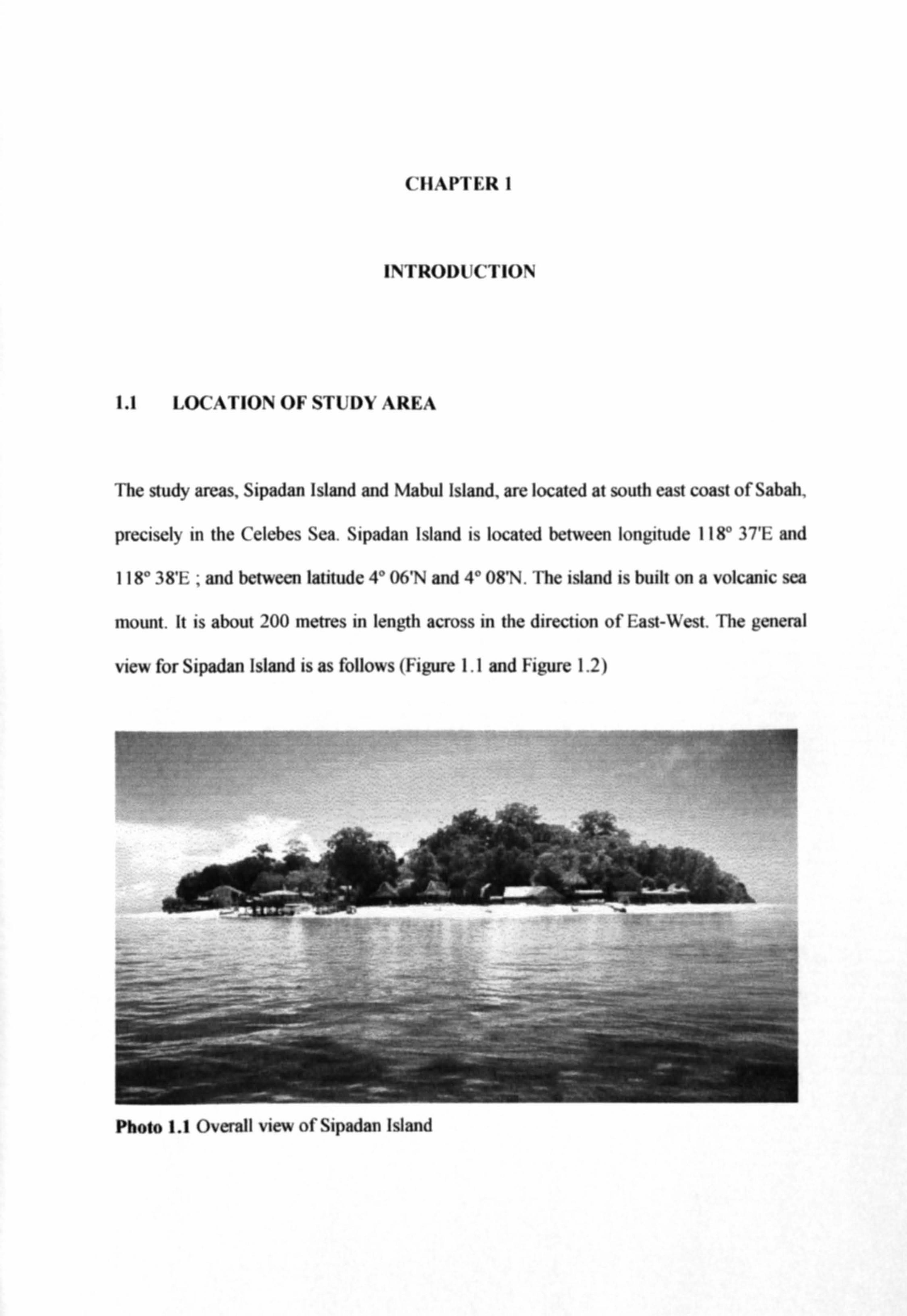
The study areas, Sipadan Island and Mabul Island, are located at south east coast of Sabah,
precisely in the Celebes Sea. Sipadan Island is located between longitude 118° 37'E and
1 18° 38'E , and between latitude 4° 06'N and 4° OWN. The island is built on a volcanic sea
mount. It is about 200 metres in length across in the direction of East-West. The general
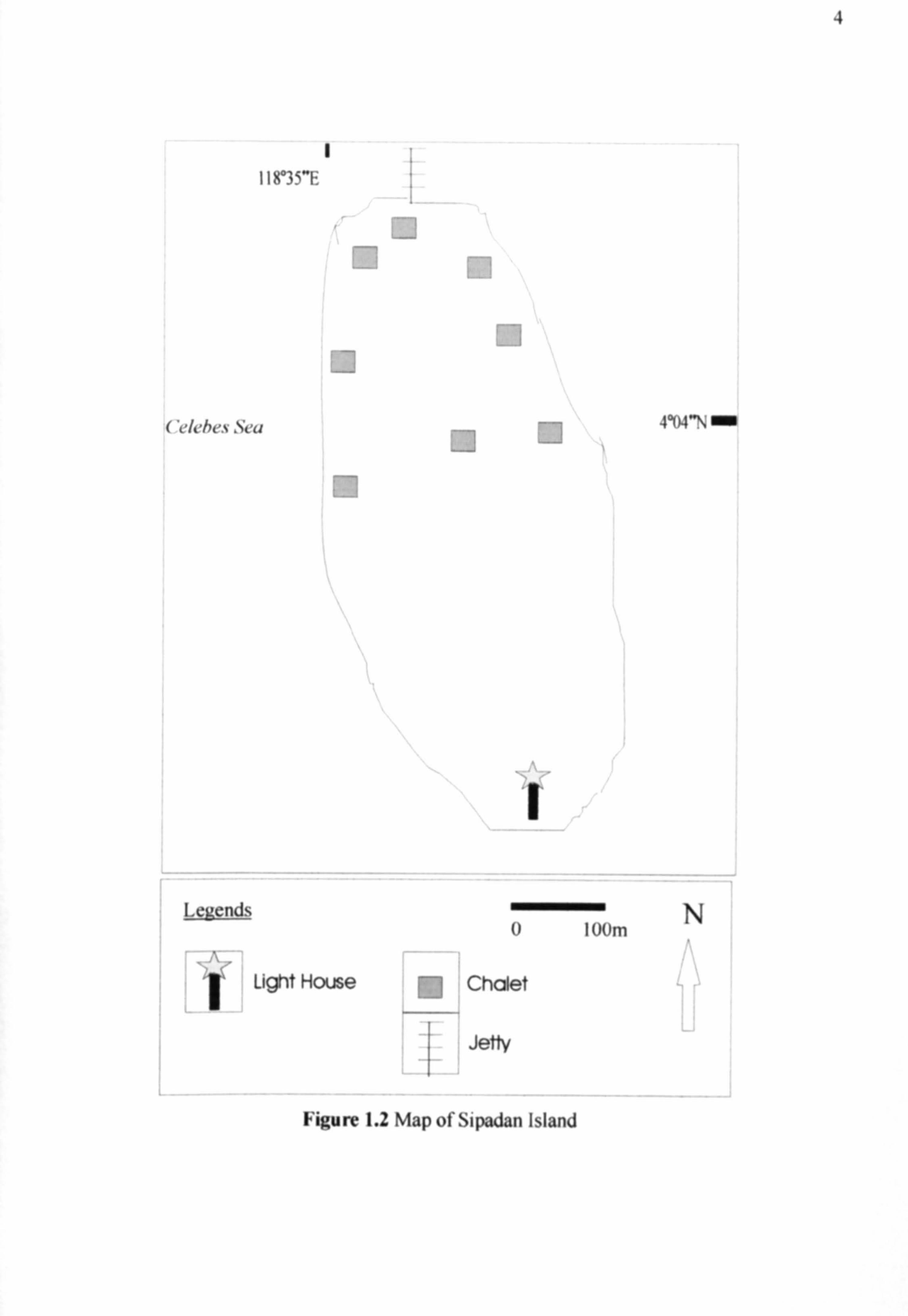
view for Sipadan Island is as follows (Figure 1.1 and Figure 1.2)
Photo 1.1 Overall view of Sipadan Island
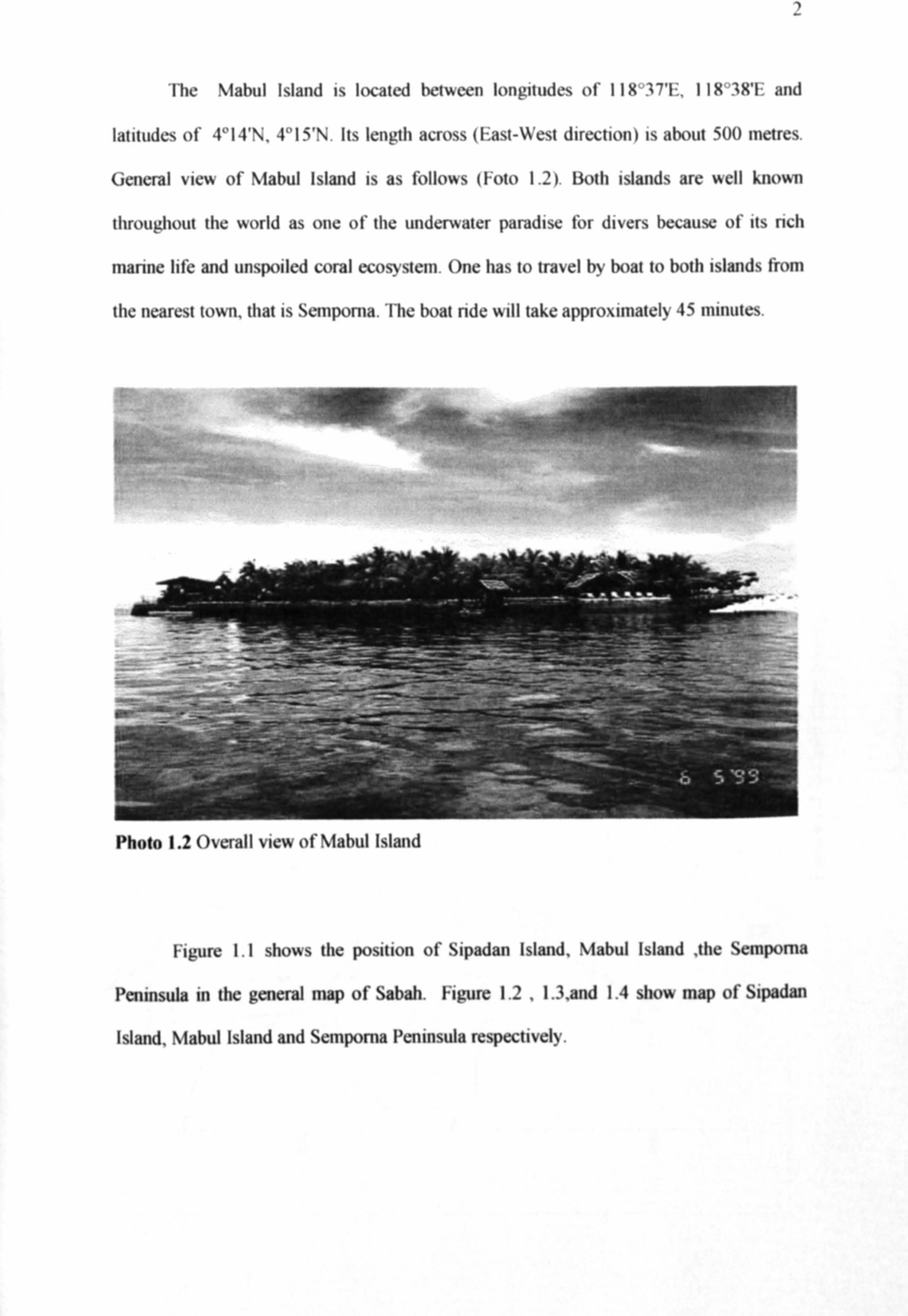
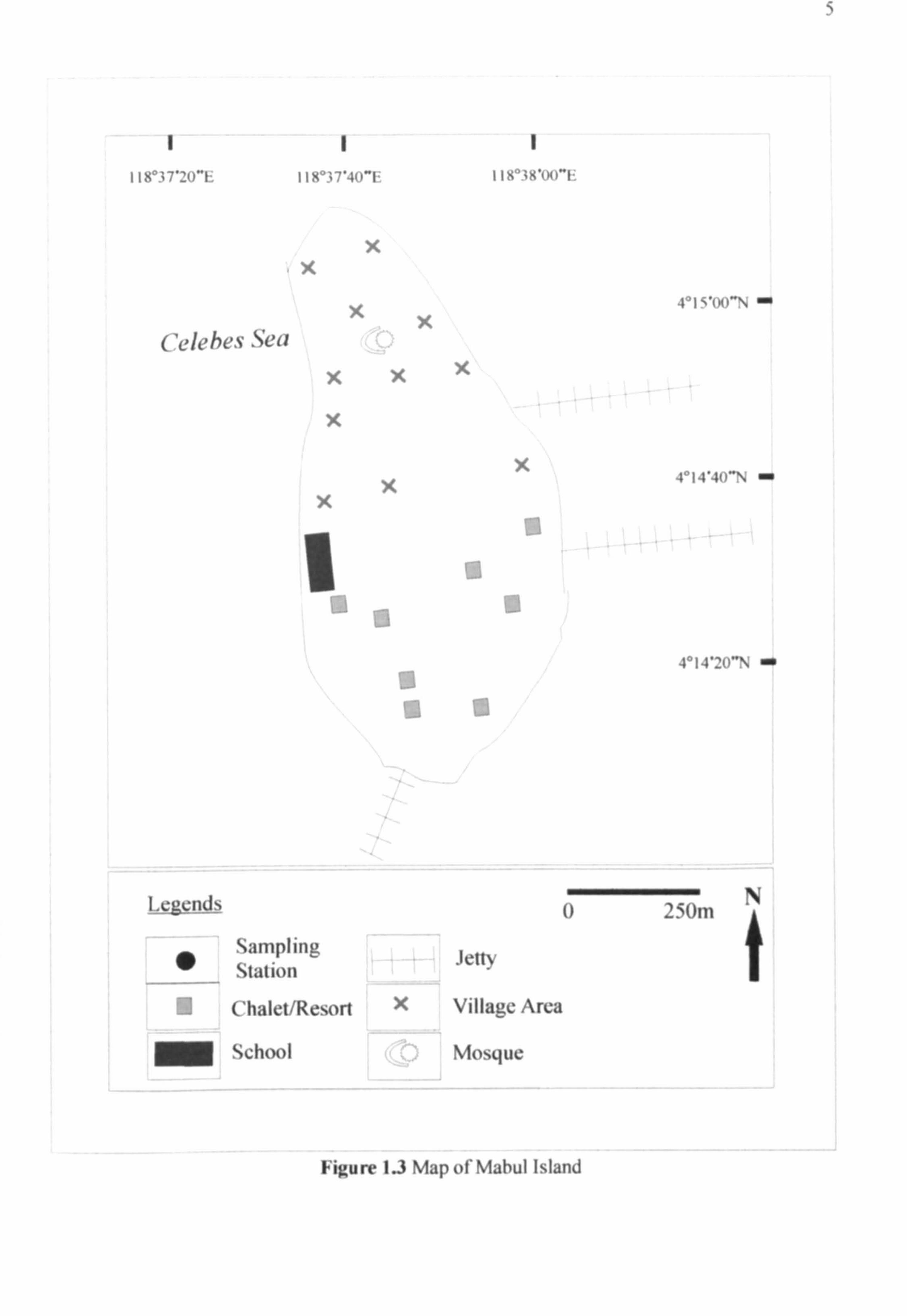
The Mabul Island is located between longitudes of 118°37'E. 118°3WE and
latitudes of 4°14'N, 4°15'N. Its length across (East-West direction) is about 500 metres.
General view of Mabul Island is as follows (Foto I. 2). Both islands are well known
throughout the world as one of the underwater paradise for divers because of its rich
marine life and unspoiled coral ecosystem. One has to travel by boat to both islands from
the nearest town, that is Semporna. The boat ride will take approximately 45 minutes.
_---- ý-- ý__- _-_ý, -_ -ý. -=s ;, ý - `r' " __ -ý7- - -" ý-ý-_-!
ý's
, _ý- c_' - -_ ýý' --... _ý-- --.. ý ý%, -
.-- -jr- --- 7-4ý i -ýýý'. i
- _-
s.. "'. ý =a- aý ý- ---. --
Photo 1.2 Overall view of \lahul Island
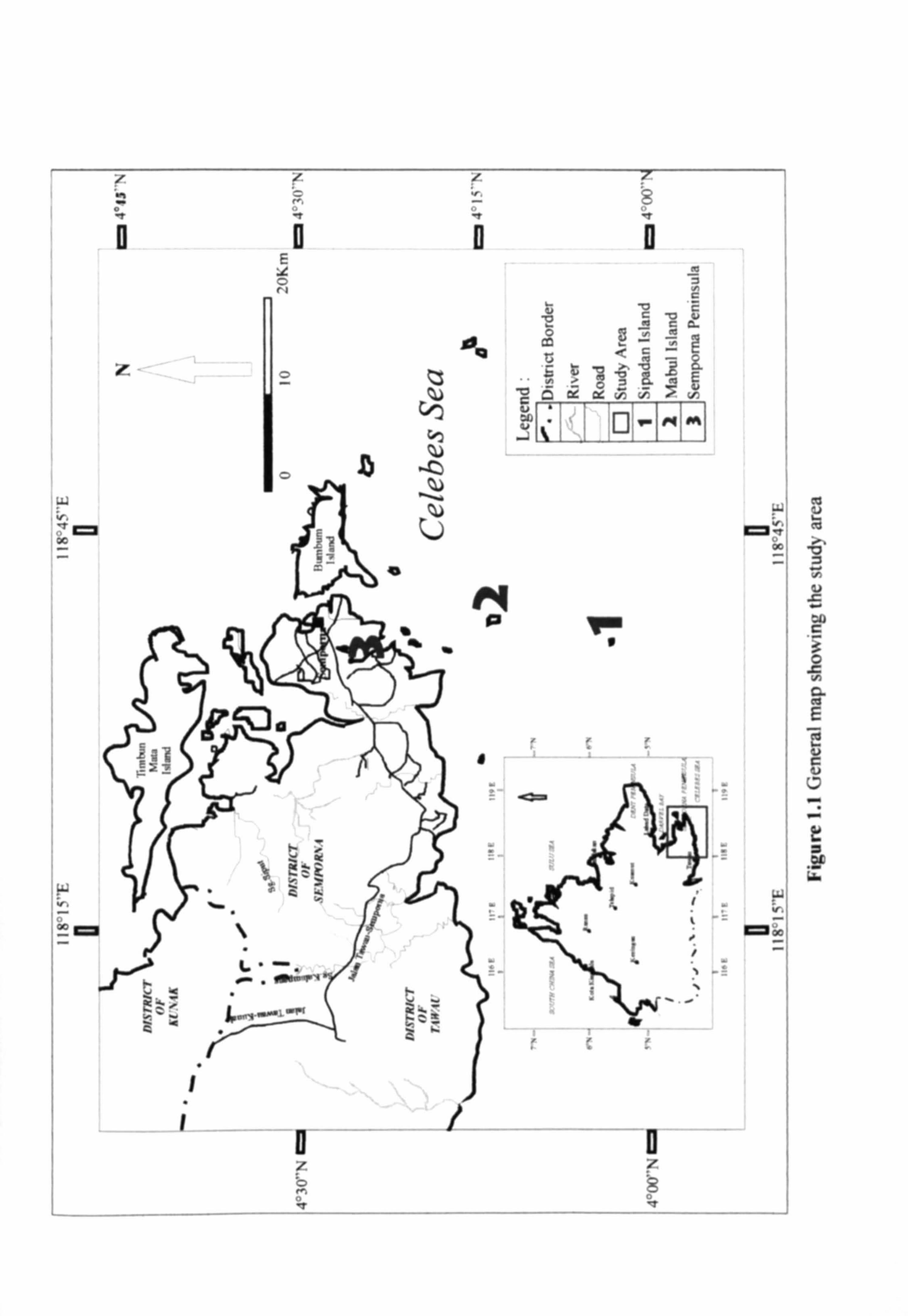
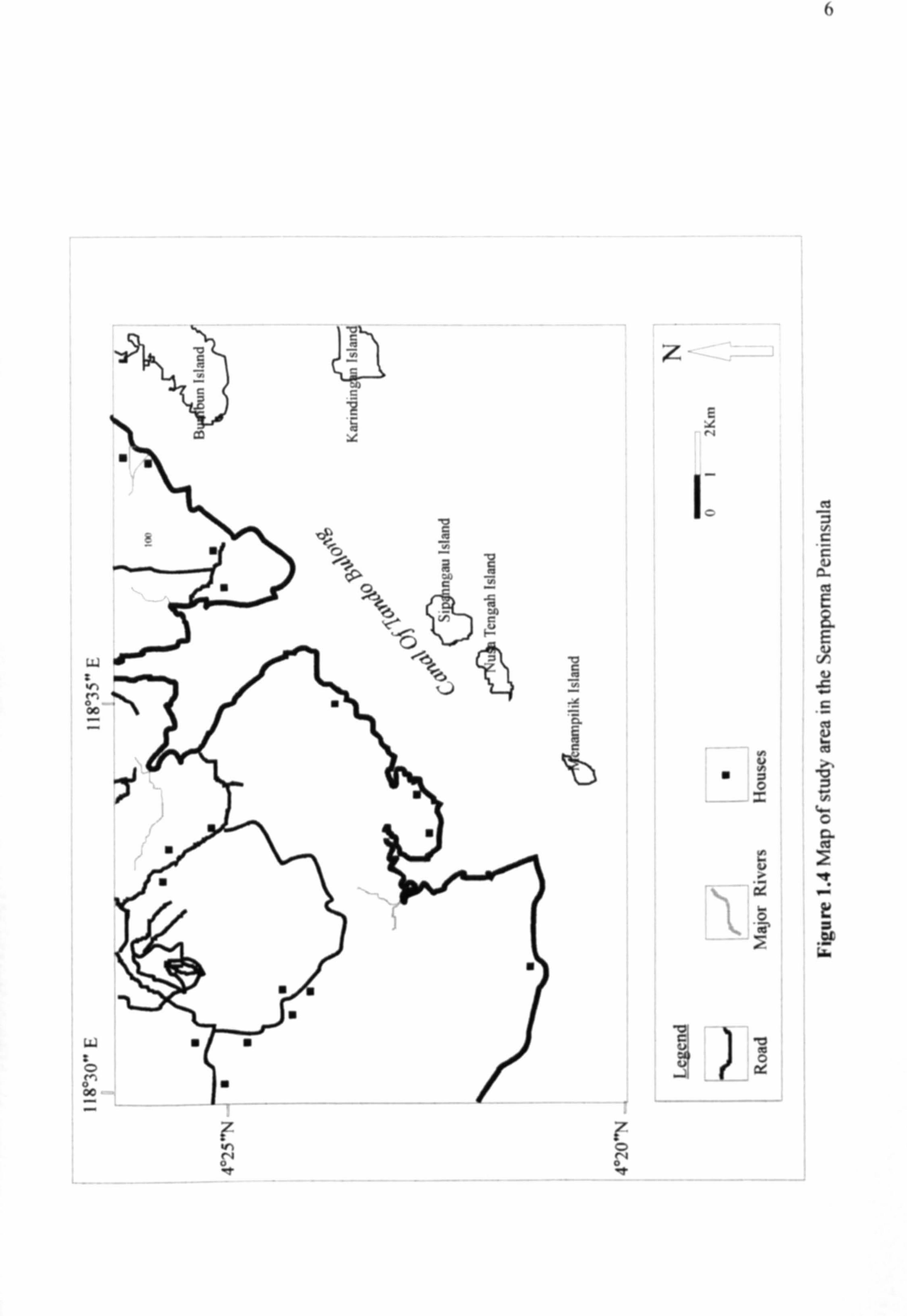
Figure 1.1 shows the position of Sipadan Island, Mabul Island the Sempoma
Peninsula in the general nap of Sabah. Figure 1.2 , 1.3, and 1.4 show map of Sipadan
Island, Mabul Island and Semporna Peninsula respectively.
! .M
II
!
C-. ý ý
F_ 1 0 f!
/ b ý 0 ý
7___--__-- -7 - Y. ý
yy
01
ý c a :L a,
ý > ý
ý C ý
ý ää c
-a 7ý ä y
ý 5 v. ý
ý ý Q ý c ý ý
E. ý ý7
VM 9
M M
7
a !
ý
0 ý
O -t
00
o60
ý
00 Z
4
1 118°35"E
Celebes Sea
m
El EI
i Legends
0I oUm
Light House 0 Chalet
4 Jetty
l. ýý ý
0
4°04"N
N
Figure 1.2 Map of Sipadan Island
5
II 118'3 7'20"E I 12i° i 7'40"F
x
Celebes Sea
X
X
XX
X
X
4° 1 S'00"ti ý
4°14'4()": ` - X
I
iix°; x'(X)"ý
X
I
Legends
W
a aa
5
" Sampling Jetty Station
Chalet/Resort X Village Area
School Mosque
4° 14'20"\ ý
l) 2 sl)m
Figure 1.3 Map of Mabul Island
X
X
N
w i
ý O 00
ý S 0 r, 0 00
ý r N 0 ý
ä N
f
I
lb
, 7. 0 O
z £
:t N
r
N
v ý Uý 0
ý ~ U
ý I-
0 ý
!
-v G' ý J ýý
6
7
1.1 OBJE('7'1VE
There are two main objectives to be achieved in this project :
Firstly, to study the basic geological aspects of Sipadan Island, Mabul Island and the
Semporna Peninsula. The geological aspects will be focused on the geomorphology,
lithology, petrography and structural geology of the study area. to study the geochemistry
distribution of trace and major elements and the mineralogy of the soil in both islands.
Other than that, this project is one of the terms and conditions set by the
university in order to get a degree in Bachelors of Science (Geology)
1.2 METHODOLOGY
There are a few methods that were used as guidelines to complete this project, as stated
below :
Early Research and Literature Review
1 Fieldwork and Sampling
I Laboratory Analysis
I Report Writing
II
R ERE
Abdullah M. H., Mo htar M. B. Tahir . 1., Awaludin A. T., t
water quality in th upper Phraetic zone f a mall oceani ialand ipadan I land
Mala ia .. Journal of Fnvironmenlal G ology 29, I.
Abdullah, Musta, Ari and Annamala, 20 . of Mabul I land,
mporna abah:
Japan, 117 - 120
can Public Health A iati n APHA), I 5. For liz
. aminal ion ofWaler and Wa 'Iewaler.
Allagu, . and Nich I , . 2004. Tertiary tratigraph and basin e oluti n, uth · r
abah Mala ia B m ). J urnal if A ian Earlh iell e 23,537·554.
Saba Mu ta and anudin Hj. abir I . Kajian g kirnia un ure·un ur dalam urn pur
dan tanah di Pulau Tig in.f; 5 47·56.
angar, K. M., I 95, Texlb k if eolo : Gen ral and Ell ill ering. tandard
Publish rs Oi tribut rs
Brian M and Carleton B.M., 1989, hemi. try. J hn Wil
of Til Je selton Kola
Kinabalu Ar a. • In
117
Herbert, . A. hin P. H., W. B. and Alan R. W. I 4. M lal
'on/am ina/ion of oil. Lew. Publi h r
}(jrk. H. J. C., 1962. The ology and Mineral Re. our e. ofTh
orth Borneo Kucing, •
Konrad, B. K. and enni, K. ., 1 5. 1111rc du lion to h mi'try.3rd d. Me- ra
Hill. New York
Lin, H. S., 1992. oral R efi of . KuaJa Lumpur, Mala ia.
Musta, B., Raya, Z. and ahibin Abd. Rahim 2004. limpahan Logam rat
da1am anih dan edimen Pantai di ekitllr Kota Kinabalu, • ',a
Journal if Analytical ienc 8 I, -104
Reinhard, M., and Wenk, ., 1951. OfTh 01 11 Of North Born Q. Hi
Maj • tat I n ry
Rinhadr M., and W nk E., 1951. of th colon of n rth
Atm dja, R., Noeradi, D. and Priadi ., 1 9. en i magmati m in
Kalimantan and its related giodynamic volution. Journal ian Earth
17 25-45.
I 1
on Pulau
ipadan. A inal Report to he tate 0 emm nt f ahah
Tan, T. H. . 1989. Kaedah okimia unaan. ahasa dan Kuala
Lumpur.
n of ahah, Malay ia. Journal of.. uth Ea. I A ian
Earth
Wit n~ M . J., bamber, J. L. •• an M. J" Mo , . 1. and . . , ] •
tudic from · Kalimantan. J umal
of A ian Earlh ienc 17 , 183-20] .