Embed Size (px)
Citation preview

- ST, -1 '". " • :• • ,• .. - "1!0·
UNITED STAT~ DEP A.R'l\fEm' OF 1'HB INTERIOR
GEOLOOIClL SUR~
WlDSIJl)E COl'iDITlONS AIDNG THL l"Etml COUNTY HIGHWAY PARALLELING UKF. ROOSWF.LT FRO~ KErtL1l. FAU.S
'1'0 TRE JS:)UTH OF THE SPOKANJ:~ RIV ER WASHINGTON
Fred o. J one•
M&I"Ch 1954
C"~··l" ~ ~' This report he~ b ('n prepared fer onen .i.e c 1~l .. . .-: ~· ! l :.; , - ~ !: . :n s:: : ~::::d forc.o:1forr:l i ly w-.,'1 U.S. G;::Qlogi-:-dl .Surv«Y &la.ndarcia aDil nocencl.ature.
-c- . ,..-- " R. 1-, ·-: - , , c. ,_ - ~-
APR 16 1154
U. 5 . G ~- -5POI'.A L. WAStt.

..
COOKIITS
nrrROOUCTica 4
.BaCt~ ot ~ 1nnaticat.101W aleag t.be vppU' Columbia River 6
General •t.ting 8
Olacial history 9
General effect or Lake RooeeYelt on l.aodal1dea U
IJe•cript.ion of landsllcle areas , potential :slide areas, and aate _... along preaent bigba7. 12
s~ 33
REFF.P ~NCF.S .)4
2

ILLUSTRATIOKS
Page
Pla~ 1. RMtd Te:mace landalide area - - )'.&7 lS, 1951. 14
2. ~ Teft'Me landslide area • AU1'18t 1, 1952 15
). LaD 8hore beMen Jlonwnent. 9 and 10 19
4. Aerial oblique looking down lake abam.nc tbe bi~7 in the falls ,reek area betasen alan-Ullenta 19 and 20 24
s. Aerial oblique looking up lake shOid.Dg tbe biBb-ay in the Fal.ls creek area between ~umenu 19 and 20 2S
6. Landslide which cut higt.&T 1D spriDg ot 1951 ill the Falls CJ'eek area bstween Monument. 19 and 20 2o
7. Landalide at Nine•U• CNek whicb coapletel7 cut highfa7 Gil Jul7 31 1949 29
s. NiJMeile Cnek landaUde on Na7 161 1951 :J)
9 • tandaUde juat south ot Ninea1le 1Ja7 wbicb .nered h1gba7 in the winter of 1952 31
MAPS
Quadrangle mapa ot' let.tle :FaU.1 l nchellmn, Hunters, ITilmont creek, and Linooln In pockat
)
I~"TROTl. C'l'ION
As part of the pi'Ogram of tbe U. s . Geological ~)ur1ey 1 land-
slides are being studied in aereral localities i n the nited States.
'l'heae atudiea are directed toward assembling criteria for recognition
o.t lru.dslides1 classii'icat.ion, a xi ca1.alo;;il'l€ of remedial or control
metboda that hav been eifttctivc. In tOt: gorge oi too COlumbia
Hiver 1n v~uhington, landslides of large magnitude have been active
internii.tter. tly &j nee the valley was first incised. Closure of L:ratxi
Coulee Lam, '"'i th the consequent riae of water forming .i'rar.klin l ~ .
Hoosevelt Lake, bas introd ced the factor of a r .:.sing and fluctuating
water t.able that accc:1tuatee tr.e incidence of la:·dslidir~g. 'Ihis area
was s lect.ed for atudy because of the magnltude o1 the l :il'!dslides and
the unknown but signti'ioant in.fluc nce of a nuctuat ing water table.
l.:ata resultine from the atuc-' ice ·.rt.ll be sl..lllmllrbed in a final report.
This report deacy·ibcs brie.Oy the lallClslide conditions aloT>.g the
hig hway on the west &hore oi' Fra::klin D. Roosevelt T.ake in i'er~J
County, :;ashingt.on 1 betwef.'" n t he KcttJ.e t·alls bridge a r.J a point
opposite the mouth of the Spok&r:e River. Areas which have bee r
affected by lancisliJ.es are outli: .cd; area~~ \'lhere landslides may
occur in tne fut~e due to the effect of the reservoir are pointed
out; a nd those areas which are considered safe .from lartdslide action
an delineated.
4
'• ·.

Prior to the conatl'Ucti on ot· Gra.'ld. Coulee Dam and t he crea tian
oi Franklin D. Roosevelt Lake in the Columbia Hi.ver Valley, ~·erry
County maintained a law-lwel road alor~ tbe right bank ot the Colum
bia River. The position of thi e original road can be examined on tt.
Col~unbia ili.Yer maps, .,-hich vnH·e pu~- lished by the u. s. Geologioal
SurY~Y in 19.)01 in coopt;rati on vti t h the COI"J'B of lk.gineers, e d tt.led
"Plan ar!<i Prof ile of t he Columbia !\iver trom the Internatio:~al Boundar,y
to 'i'c'e natchee, ashington.n Sheetll 3 a::d C aha. the area in Fer17
County under conaidei'Qtion. These mapa are not an essential part ot
this report eo eopiea are not included in it.
The creation of the reservoir necessitated the relocation of th11
vi tal county' transportation route above maximum •ter leYcl at
eleYation ~90. The position of the relocated route may be examined
on the fiye quadrangle abeet.B incl uded in this report (Kettle .Falla•
Incheliun, Hu:1t.ers, \ il.mont Creek, and Lincoln quadr~gle sheet.
in pocket). For the rr.oat part, an entirely new route •s selected
a nd the highway buUt, b:.tt in a few places short sections of exiating
roads were improved a r.d uaed.

Background of landslide iDYeat igati ona along the upper Columbia fliver
OWing to the u,.lq)eeted and gnat tnqueney Wi tb lib ich
l~dalidee occw-recl along Franklin u. Roosevelt I.ake in tlvl first
tew years of 1te operation, a atudy of landslides waa begun in 1942
by the . .mreau of Haclamatian. This atu<iy led to a p~li.'Ttinary
landalide classi !icattoo of most o.r the 000 to 700 miles of lake-
shore land. The geologic condi tiona a.·ui 1.opograpbic relat.i.onahipe
1--ere studied, nn<i t,he res~rv oir shoreline was classifl.ed ceuerall.y
in to live groups & 11lan~li<ies likely 111 "landslides unlikely 1 11
"slido areas, n '' l:e· rock, 11 or n i dot.crm.iua ~.e. 11 'lnc maaLi.ng oJ. t he
class .i.i'icat ion is sel!-evidm t. The indetenuiJlate categor.f ..
neces&4r'J because thE- re were mailY places where it waa impossi ;)le
t o hllik1t a vali detennination of i.he la rdsl i de poter!tia1 frolil the
data wt>ich existed at the ti11e. Jn the course of the study,
partic~lar attention was directed to areas where lar~~lidea mi5ht
destroy private pr'lperty or e ldanger lives.

In 1948 tbe Geological Survey llnclertook research s t udies
of the landslides in cooperation lfitb the Bureau of Reclanation,
tbe Nat:l.onal Park Sei"V'ic~, and tbe COI"pll of EDeineen. oot.b the
early investigations of the Jureau of Recl.anati.ao and the later
studies by the oeologiaal SU!"Ie:Y were under the ciireotion of the
writer. he &tud)• now in progress extends frOCil the Interna t-ional
Bourdary downatream almost to Lnief Joseph I*t11 which is under
corl8truct1on by the Corpe of !..ng:l.noera. 'rhe purposes of thia
investipation are to oontribute to t.he underata .. ding of' la:ld
sliding aEi a geologic process, and to develop criteri a for
predict ing the probaule arno"l4nt o.f lakeshore land whicb wUl be
ai'1 c c;ted 'jy landslides ao that I:l8Ximum t illiaati on cat be made
of areas Llelir:ved 1.o be stable.
7

General setting
'l'he Columbia ~iver ·; alley ! r·oa the International 3oundary to
ita connuence w: tb tbe Spokane i 'ler lies in the Okanogan Highland
physiographic province (Pardee, 19181 Culver, 1936, and l·lint, 19)o1
P• 1849-1884). Thie province oeeupiea that part of the state north
of the Columbia ar.d ·pokane Hi.'fera, betlreen the Caaoade !1ountaina
on tbe weet. and the mountains of' Idaho 011 the eaat (J..andes, 1902).
1 t is made up ot north-south trer.uin ,. valley• bet.we;_n low, parallel
mountain ra; ges. fhe most comtpict.:.ous oi these north-south valleys
are the Okanoga n 1 .jan f'oil1 (. olu.mhia, anci ·end oreille •
Luring the Paleolltoic and :P.sozoie eraa1 the area. CClmprisi.ng
this provi1:ee waa • sea ( i ·ea re r , 1918) . em the floor oi this seta
weN deponl t.ed sedime :•ts of mud, sand 1 gravel, a nd other n.atcriala
which latc1· upor. consolidation becane shale, sandstoz·e, co~glomerate,
a nd limeator:e. late in the . ~eaosoic era great. quantiti es o.f r.ranite
were intr1..ded i nto these rocka (?a rdec , op. c1 t.) ar:d (Weaver, ~920) 1
and the land waa elevated to form mountaina hie her thl.~ those which
8X'i3t today. ! hese processes re:ttllted in the !Mltamorphi em of some
of toe sedime:1tary format~ ona to a rgillite, quartsite1 g 1eis& 1 aehi.at,
anti marble.
8

The inti" .lsi ona ot granite and t he regional uplii't f olded the
roeka ao that at the preaent time th87 aN not in a bol"isontal
poai tion but tU ted at varioua angles.
Beilreen the time of theae geological w nta and the Ice Age,
the chief proana. affecting t he Okanogan Highland prorinee waa
erc.ion of rock valle711 now occupied by pneent atl'eatr:l.
; laqial. hiet.ory.- The CollU!lbia aiver ·;alley throughout thia
nortb-aouth eection waa glaciated and influenced gNatly by glacial
damming farther downstream in the Big Jend. As the ice sheet !omed
1n the north, tbe ,olumbia River becaroo swollen 11l.tb glacial melt-
water and scoured the lower part of ita valley nearly cl<!an ot' saud
and gravel ~ · lint and lnrin, 1"391 p. ool..080) . 'l'he l obes o.t' the ice
sheet ac.Wancecl southward along the Okanogan, San PoU, Columbia, and
Pend OreUle /alleys of this phy s iot:raphi c pr'W ~.nce • Prior to the
filling of the Columbia Ialley by ice, the l obe moving down the Okano-
gan ·ralley crossed t.he columbia valley in the northern part of the
llig Uend a nd formed a dam ( !:!1'8\z 1 192) 1 p • 57.31 Willis, 18871 p. 4 71-
' 4801 nint, 193~, P• 169-1941 a nd Flint, 19.3b1 op. cite) • I nto the
lake thUI created the swollen Columbia River carri ed great quantiti es
ot glacial nour ltlicb eettlcd to rona br.ds or light-colored silts and
clays known ae tbe i~espelern silt (Pardee , op. cit., and •lint, op. cit. ) .
9

Ai'ter thia initi al atage of deposi tio , t.he icc advanced and f l llttd
the Yalley. It has bee .. eatimated t hat the i co was more than 41000 feet.
thick oYer t e floor of t r.e Colwnbia Hiver ·'alley at the norther .: edge
of the Colville I ndian Reael"'lati on (Pa rdee, op. cit.} • The overriding
ice masht_d1 pusheu, and consolidated the unde1·1ying lake beda. In
wasting away, the ice releas~o great quanti ties of s i lt, ~id1 grayel,
boulden, ar.d a ngular rubble. Depos · ta we re laid down alongside tbe ice
tongues a :1d in tempor ary lakes created uy local ice d~ a. l n 11108t placea
theee materials were 5orted into beds of silt, s and, a nd t,rravel, but
locall;( t. nsorted de posits of t :i 11 are f ound. 'fhe details of the ~lae:tal
hist ory ha\·c r.ot bee n completely worked o ut. The ice may have advanced
a nd •sted away more than once, each such stage being accompanied by
!eparate stage& of da; tminr. a nd lake depoai tion . The formation of a
lake in wilich sllt deposition took place followed t}1.e fUling of the
'Iall ey by ice (Flint and l i'Win, op. cit., .tlint, op. cit., a nd Walker
a nd Irwin, 1952) • jjuring and f ollowing the mclti nJ; of the ice dam
dowrl8tl'eata, the s t1ll-awollen .olumbia cut ito. way tnrou·. n the so1't
allta, aanda1 and era.V' ls so rapidly tbat it did not exoaV'ate all
t hese materials alor,g thE! 3i des oi· tnc valley. ';'beae remai r.i ne de
posi~ now compose terraces oJ silt a t:d clay with occasional interbeds
ot aa~.d and gra ·el. Some oi' the beds have bet:n greatly de!ormedJ
ot.hers appear to have been only sli!~tl.y deformed; b t basically they
are all similar in thia north-south secti on of the river. Sn~1ds and
graYels and a thin J.a ·er of soU cap most of the terracr·s.
10
studies of the terraoee and fill ~ta show that landllidee
wre YaJ7 actiYe in glacial times and that they have continued ever
ainoe. Aa the river eroded into tbe fill., 1t.eep slopes developed and
landslid-.a fed thei r oharge ot material• into the river. 'l'erraoee at .....
Jll&ny le•tels show the topographic (orms ot old landalidea • Thay Rppoar
to have (:CJnati tuted one ot tbe major proceasea in the dissection of tho
f ill into i t1 p~ent fol"'le
ueneral effect ot I.ake .. oosevel t on landolidee
Several largo lanclslidea haYo be<-JD recorded in thia p uoral
north-s (Jut.h aectian of tbe Columbia River in Matorl o t i l:.es prior to
the exiatence of Lake Rooeevelte At leut two of the landalidee nave
been large enough to clam partially tho !low ot the Columbia 1Uve1· i'or
short peri oda •
The creation oi' Lake n.ooetrf'elt by Grand Coulee Dam cauae~d naw
landsl ides along the lake shore. New areas became act.iYe a r d old
landalide areaa ahowed renewed ac t iY'i ty. The saturatt on of the bank1
and t.ha buUding up ot the •ter table that acccq>ani~d too i'Uling ot
the lake introduce new load factors whe neY'fJ r the lake lwel ia loWt'trctd
during the operati on o! the reservoir. ~ater ia retaint!d in the liltl
and clays because it eannot drain out as quickly aa the lake level Ol\n
be lowered. 'l'he additi onal water, pll~& etructural •akr ess o1' the
clay, silt, and aand bads due to aaturati on, makes ateep banka unotable,
Bedrock in the Col1VIbia .IU.ver valley ie general.l¥ •tabl e 1 and
landaU des take place w.:.. tnin tne unconsolidated terrace &ncl tUl do-
poaita1 or at their coutact with tlw ndorlying bedrock aur.facoe
11

Landslides have occurred at many places along the Ferry County
hig~ due to the effect of Lake ! ~ooeen~lt on the geologic environment.
Deacription o.f la1dslide areas, potential slide areas, and safe areas along the p1"6sent higlway
!/ Foz· reference purposes numbered monuments have bc~n oatabliabed
L' 1 he monuments are 411 x 4" posts painted white ar.d located aa .follows&
l!om:ment Mileage !rom junction Location of monument with number of State Hi~hway .3 a rd respect to c ntar line of
.hemar c re,?k Highway road.. erocedio,& aouthwarg
1 ~.S2 .30' left 2 11.41 20• left J u.su JO• right i, 11.90 20• right 5 u.oo 201 lett 0 12.10 20• rigllt 7 12.)0 20• lett b 12.50 20• J"ight (;) u.oo 20• right
10 1).91 20• loft ll 14.22 2S• right 12 ]4.40 25' right 13 u .. 53 )Ot right 14 15 • .38 20• right 15 15.59 20• right 16 lo.61 20' right 17 17.41 20• right 18 1s.rn 20 1 right 19 42.?4 20• right 20 44.84 20 1 pght 21 45.40 u• right 22 4be8? 20 1 right 23 ')5.47 20• right 24 S6.16 201 right 25 61.00 u• right 2(.) o2.)2 15' right 2? ?4.02 20• right 28 ?s.os 25• right
along t he highway to show locatior~ at' tbf; sec tions to be described
(see enclo•ed mapa). 'l'he ~J secti ooa described in the !ollowill(S JXlra
graphs begin at tne we•t e nd oi' t!le Kettle Falls bridge i n the Kettle
.~.o ·alla quadrangle and cxte11Ci downstream to a point opJ:;osi te the mouth of
t.be Spokane id.YW in the Linc'lln quadrangle. The .t'irat two aectionB
&1'8 north of ... fonUinent 1.

Pndictiona o! landallde poe~:;,ili tiea are bu.U on obaernU008
o1' bwKinda of J..and8lide• and ot alopetl in uncOMolidated materi.aJAI
that nan not been atteotecl u yet by land8J.ide81 \bat baft been
ill progna• through a 12-year penod throughout, \be extent ot tot.
ftMJToil'. o'*'..atioM hue been made ot the nature of tne un
cooaolidatecl •ediaent81 the surface dnina&e and g~Gund atar
condi tiona, the poai t1on and •hape or tbe buried bedrock •urtace 1
and t.he height. L"ld liteepnees of the p~eHnt •lope ot the unconaolidated
d~i ta 1 both tbe submerged po~··t.iooa a f.ld thoee a bore lake lwel.

Kttt.le FJ1ll pride! to SIPfW! cnek • J!tt.le lalla q!lldnncte,
The hist-7 in tb18 eection cl"OI._ an ana whiab 1a underlain b7
bedrook at. a relaUYely aballow depth, ~Jut in 0111.7 a In plaoea 1a
rook actualq expoHd in hS.g~y euta. Tbe glacial Oftl"burden eonai•te
of silt, clay, And, graYel, and till. The road grade cut. pointa and
ridgea or all tbeae material.a aoo the t1lla are constructed on tbn,
It is not like]¥ that lamalidea due t.o the intluence o£ Lake Ro~nelt,
111ll develop in tn1a aeotion. rlecause grourd •t.er 1a preaent noar the
aurface on the valley aide above tbe higbAy aorae failures or the tUlll
may be a r.licipatod wbon fill reate on aUt arx1 clq,
ubeman creek to .rJonpnt No. 1, Kettle i-alls guadrang1e·-
In thia aectioD t.be highway cro.8M one ot the 1108t acrtiYe landslide
areaa 1n the upper Columbia R:ber Valle7e Thia aroa ia kn01m u the
Reed terrace, and ia CCIIIpOIIed chiefi7 ot lacu8trine allt and clq.
A large aection of th hiebny •• taken out c~le\e~ on t.h18
terrace in the apl"ing of 1952 (see Platea 1 and 2), . The elide
neoeaaitated a t.lpor&1'7 relocation ot thiD higa.ay, Det.aUecl dt.e
atudin would be necessary to relocate ttda section permanent.17,
Uonument No, 1, Kettle f alls quadrangle, to liClllpnt. No. 2,
Incnell• quadrapgl.e.- Throughout thia aeotian tbe big~ ia tar
enough &laQ' £rom tbe lake, or the geologie condi tiona an such that
lanclalidea will not affect the safety of t.be highway •
13

PL\'!'E 1
il.eed Terrctce Landslide Area• 'l&ay 15• 1~1. Between Sherman Greek and .t.r.onument. 1
Kettle Falls qWidra ugle
Photograph 127~

R f'cd Tt· rrac c L.1 n ds li de re:.1 ,
} · 1 d. t
M a y 1 5 , 1 95 1, betwe en Sherman Cre e k a nd M onum e nt N o. 1, Ke ttle Fa lls Q u ....td r a n g l e
.i-' hotogrctph 1278

PT.ATF: 2
!iced Terrace landslide t\rea, At: •"Ust 1, l r)52. Between Shernan ·" r et!< ar!d .• lonument 2
r.l.:' t ~le r al l s quadrangl e
: hotor;raph 1279

~\e e d Ter r ace Lan d sli d e . \. red , A u g ust 1, 19 5 2 , b e tween Sherman C r eek a n d Monumt.nt No. 2 ,
K e ttl e F dlls ~ uw. d r...1ngh:
l- hotog r a ph 12 79

!ionument f~ o. 2 to Ltonu..-ent io. ) 1 Inchelium quadrangle.
Along this secti on the highway is founded partly oo bedrock and
partly on beds of unconsolidated silt, clay, sar.d, and gravel •
.l n several places tJ1e road dips slightly and one s.all al ide occurred
about 194b. 1 t is likely that a part of this road will be lost by
small l a ndslides. lf this secti on of the road were widened an
average of one-half the highway w.l. dth on the rock-cut s .Lde, a safe
foundation would be provided.
!.~o u:r ent !~ o. J to tonument No. 4, lncheliuL'I quadrangle.-
I . this sect.ior. t he highway crosses a n area wtd ch is predomi.nautly
interbed led silt a rid clay. Above t he hJ. ~~ ·lWClY, ground water is cloae
e nough to the s urface to subi.rriita te a steep hillside fleld. This
section is likel y to slide out, ar~ additional studies would be
necessa ry eithe r to r elocate t he highway or to establish a system of
drains of adequate :Ji ze to safeeuard the prese!lt locati on.
~onument ho. 4 t o · ·onument '•o. 5, lncnelium guadraog].e.-
The fourdatl on f or t!~ hi Yhway i s on bedr ock between thea . two points,
all(l t.here1 ore i s .1ot a •b ject to sliding .
16

Jonumc n t r.;o . 5 to !~on ur.:ent . o. b, I noheliwn ouadra: gle.-
The hi 5hway betwe n r.' o : .. lmre nts : 'os. 5 and b i s cor ,structed principally
or. unco! s olida tee.: Pe 's of ail t a .. d clay . 1 he bedroc k s ·· rf'ace lies
oJ t a s nall VI dept • T;:t ! ~dsl .L ~ ' s " ~· ev l :.1i uholly ·Ti thin the st :ri · cial
materials 1 or laz osL des coulu ut:velop al0i ll..: t il€ cor: UJ.c t be twe en the
s .rl i cial r.-.ateri.als a ·~d tllt-! be<1rock . Lctai l c:d site studit.:s r~ould
1>e r .eccssary t o e · t her relocu te tn.i::; s c ,_ t. 1 on o drain the po t..en tially
·l ,r,s tabl () ma'tt-! rial.
!.onuu;e nt ·.o. U to ,\'Of 'l;;nf' llt r: o. 'is t.Chelit:m Ql adrallt;le.
JU.on1~ t nis s e c t i on t he slopes of t he terra ce i ront tmmrd t JC lake
ar s f f ic iuntl;y ~~c· ·tlP t nat landsli des a:c-9 r.ot li kely a ·1d the present
l ocation i s ('o .. s i dered safe .
7 to .t.Ont!.-nent o • ..;, 1 il lCheli um q 'adr·n.e:le.--
The r e are several r e c . ·· t lat,<.:.slides in t his s ect..:. o:· . J r~)t:.'12 watc.r
l s very close to the s;.: r 1.·a ce , ,~no wat.:: r s e ps i nt o tho ditch on t h .
upper s -·-- d of the hi :rhway. l t s c:c ·~ts ;:.: os ~ :i '1(· tr.l3t laJ•ds l · · s col.)ld
·.a ··· -.c r: L"1 ~.nis s ~: n t:J em o>•ri·1:: to :..i o .i' r'cc t ol· L ke ~oosevslt .
rece ; t faih.res, nowever, r.ai.'c r ot be~1 ~ · ca Lscd by Lak.e !loosevcJ t ,
· t h.ave b€ .n cuuscd ~ , ~; lm: s. alL ... · ·1a t cr t ; ble a ::ci lac r, of , dcq~.1 te
17

o . 9 , lncllcli ).;!]l qt:adra;.gle.-
1 r this area t he hig hway i s fa. .·nour h a ·~a~· from th£• lake a nd
geologi c condi t· ons are s uc h ttat landslides i'lill not affe~t it.
··onumc nt :.o. ) to ont;ment i:o . 10, lnchclium guadra ·:el e .--
"he hi f," llway parallels the ed;?e of r. .1e lake q .:ite cl os ly in this
sect i on . I t has LP. c·· n onstr ... c ted in r;l ac) al i ll r.-·a tc rials su~h as
silt , clay, s a;. ti 1 ·' ra !t.:l, n t.l till in mos t pl.accn, •. t l r.cally is
c t: i into bE-drock . I hick ~lope: was it a : d hul;c tal t. ct6posi ts c:x te .d
over t.t: la.n:inatcd s i l t a . cay ir· r..any laces, ;, ut:. riG •mly _lace
.. :.ej ca: 1 -, 0 1-.S U l~ E::C i:J .1.1 tJ ,(• Gl i.C!E:I S a t ti 'iiaV J r: ks br·l0\'1 the
.;. ·hway . ~ lt:r ~ arc · .tree l :L<i.·li.J e n l r1 tnis s c.:: t .: o :1 , m e of them
C < t l i n. ·ac 1: t :> L, 'JJ. , te: G..t_•c o~· t i'Jl:: r 1ad s~.:~ri'ac • ..seca •. se COl -
tin:..: ed l a.J tdsl i tle ac tivit.\ na~: b e :,p ctcd, tl.e taile( site Stl•dies
wo d t.:c ~ .eeded as a !:J.;;,. ::; i fo !· reloc :.t t .. 1n ~~ n r u;· : l t he a e<l or of
placinf t :~c rJ ,-nwa: :~ rade on beJ r , c ~ . r latc '" . J ill·.Jstrates t, e
conr ' i t :. o r:s a l on . t he. inOflt l~I s t a: le part 0 1 ~.:i s s e ct.i.on .
" om.r-. t \ o . 10 t nc helium q t.a drJ ··f;l e .-
·- ~ ( ~ h:i .·hway :\ s co r st ~ ·cted o: i 1earoc~ al an .. t ~~ :.; s cc ~ : on a :td is
..
1 '

!.a kos horo betwer n '! O :' l iml~. •t 9 a cl ··or. :-:ent 10 - f· c hcli um quadrangl e - All.'U3t ll, 19 ~2
! 11nt ovraph 1211

I . • kc::.horr· :l l'l\\ ' C'L' l ~ r. : o n u . L'l1 l q ,t nd ~ onunl ent 1 0 , Inc ll c:'li u; r Quadr.J ng l e, . \ u gus t 11, 1 952
J h o to gr ..i F h 12 1 1
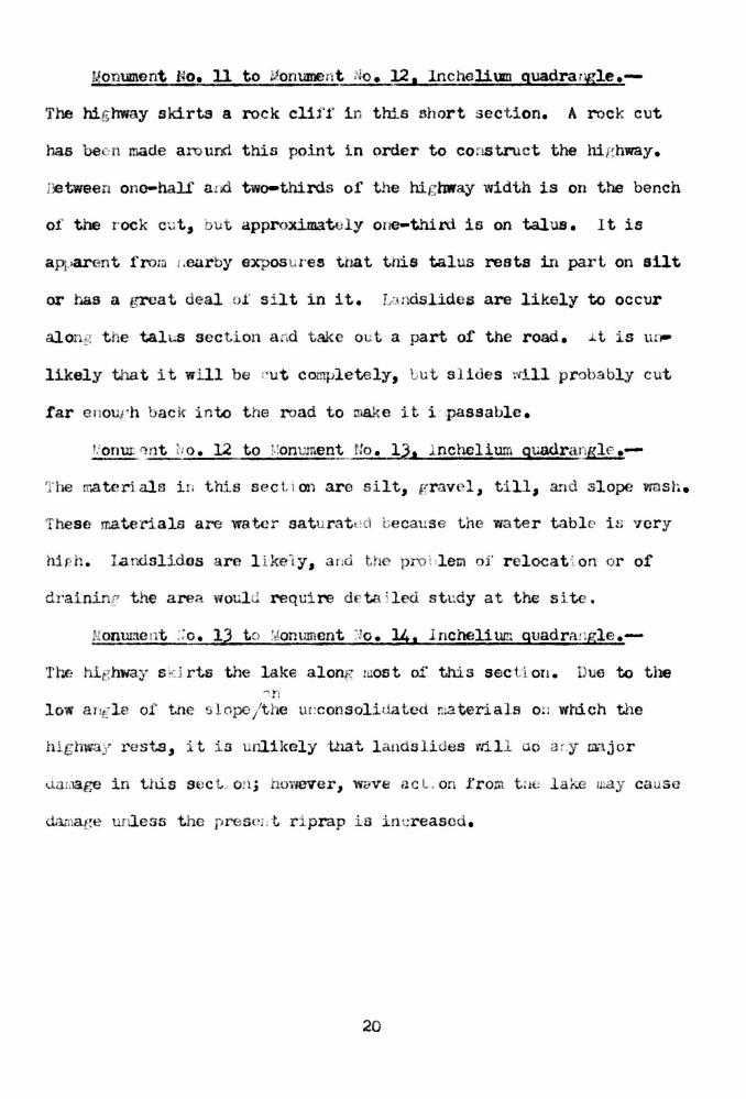
!{onument f.1 0e 11 to J onument .Jo. 12, Inchelium quadra ngle.-
The highway skirts a rock clif f in this short section. A rock cut
has be -· n made a ro und this point in order to cons truct the highway.
J.)3 tween ono-half a iCl two-thirds of the highway width is on the bench
of the rock Ct; t, but approrlmately one-third is on talus. 1 t is
apparent froru ,,earby exposu re~ t t1at this talus rests in part on aUt
or has a great deal o.f s i lt in it. La ndslides are likely to occur
alo .. g t he tal s s e ction a d tal< out a part of the road. J. t is u~
likely that it wi ll be <'Ut c ooq;letely, l.i ut s l i des wi ll probably cut
tar e nour h back in to t he road to :uake it i .passable.
t o. 12 to ! .. onument No. lJ,a l nchclium quadrangle .-
The materi.als i n this sec Li on are silt, gr avel, t i ll, a~d slope wasl~ .
These materials a re water satur a t ~ cl l.iecause the water table i n 'Tcry
W.$! h . landsl ides a re l i kel y, a nd t he pro l: lex;1 of r elocati on or of
dr aininr t he area woul requi re dcta ned study at the s ite .
J!onume nt :;o. 13 t o :~onument ~~o. 14• Incheli um quadra!lgle.-
Tl"'..e hi _,hway s l.:i rts the lake along 1 ost of this sec ti on. Due to the
low ar -l e of the -. l ope j the ur:consolid.ated ma terials O ! J wtdch the
hlghwa' rests, · t is unlikely t...~t l a ndslides rli l l d.o a r.y major
u. r:age in this s ect_ O?l j however, wcve ac L. on from t :1e la~ 111.ay caus e
da; a ge unless the prese 1t r i prap i s in creased.
20

~{onument No, l4 to .. onument No. 15. Inchelium guadranglc.
'l'hc rna tcrial alo:1 this section is s j 1 ty, a .d crcut~d Yta. ter i s close
to tr.e s urface. 'l'he.re is a sprin, · arna j ust above t t.Le hi&hway • a nd
a s mall strea1. r uns in the di tell ai 10'/e the road. ;~ lar~dslide here
would probably i e due more to t he: sprinc s thaJ, to a ny en·ec t of
Uikc r<oosevel t. As a basis .:·or L provinf t h:l & aection, stuci.ies
~ltot<ld ~e made o.f ope , . ir~ the s pri:l;, ami dra i ning the water off'
t he area ,,t;are tt mi t!ht induce landslides.
r onu.,ent 1\o . 15 to '.<iomunent !Jo. l o , r: chclium quadrangle.
"'he hi~hway follomJ closP t o the lake which i s shallow for a :.:on
siderahl e d ista~;ce out from s110re in this sect ~ on. A lart.:e part
oi: the hi t:hwa, is on bedroc k, P t: t in places the hir hway f ill rests
on talt.s depo3its 1 till, silt, and sil t :r s lope wash . '1 here may be
r.li:~.or 1~-:. dslldes alon.: t.l1is stretch , or- it may be cia· .a.r;ed by wave
acti on, b1: t failcres of :- a jo; proporti on are not ex1 e c ted . i• all
slldca may develop .:_!1 h:i s sect '. or. bee .s E: ihF; r oad h.as >een cor
stncted on s 'lty J' u:-;dation mi:ltcr5als
o. lb to ~on'l:f.l(; :lt .':o. 1?, · r.C flt..: l i~; q a :r u:.f:lE·.
'Ihc hi,· hr;ay between th s e two po:;.nt.s is coLstructeo prin ·~i;:-ally in
r ock ... uts . 'l11ere ' ill be !tO l a1:<.i.s UJcs i.n t lis set: -. ion d e to
resc:r :~ oir ei'fects •
21

J.!onument No. 17 to !o!om.!.'l\ent No. 181 Inc heli um quadrangle.-
In this s ecti on t he road io farther back froro t ho lake than i n the
area to t he north. Ther e are some r ock outcrops betwe<.;n the highway
a !1d t!•c lake . ! 1,~drack is s hal low t hrour hout most of t his area, overlain by
varyi ng Urlckness of s i lt a · , clay . The draws arc heavil y char ged •ri.th
[ I'D \.:.ui watCI· , ani t lie hi :.;! w.ly itse l f cuts throw~h s i lts. :;mdsli.des
arc like l y in t he dra~ 10ar the "o r t 1er r ~ er:d of the area a ~ .d
possj.bl y i~: secti ons of \.h(; s"' t. t.:.er .. ~: n<.! j however 1 :ivmc of this
oec tion is safe owin,.. t o t he pos .' U on a1 d sha !'t or tlle bedrock
sur flL e . ,: o~. s i derahlE: detail ed '0 n< \'l.ll..~u hav e: t o 11c a o: .e · n O \... t-
l i nin,, t 1'- po s~t:i.on '-' .f.' bc·t.1roci<: a : j t..~ .e uop :.s of sil t a :,<J c l ay to
uetennino ,i ust how Jn t.c b of 1..i1c; road is s afe a . u how n;ch is not
safe- .
· ilrnnt : r ce:: k qua\ r · ::, l~. s .-- h' ;..,L ·hway a ] or. r_; thi s area i. · fa r
Em :• u. ~l a ·::'.\l f r on t he l a .·.e n· t he f" \::Ol ~;i cal condi t::.o. s arc ~ •ch
tiw.t landslidc.s are !Jot l i kely to a ffoc t it . ! ne bi t h'lla.l l i ~ o
r nck in places - - ·.n other places · l cl't.s thro\. ;< h unconsolidated
Ut;posits ol sil t. an ...:. til l • . , o .:t! o t l e road L lli ac :·oss t ne vall y s
are pl c . on s.i..lt at .d s •0\'> s c.. t t.l t:! l- t t . r r,1m t i .-.e to t i1r.c .51~
slide s hav e: cover ed he r r. ad c e~ l... ::;iJ .<:· o .• e r::a int e :.c 1ce dif -icult.ies .
~mall i .U L:r os a~ ·e l ikely in t.lles o s i lty a r ea s in tlle J.'u t ure 1 ~) t
tt ey woW. .. . . (; t be ca .sed by f_;l.hO f·.c, osevelt, ~J' ,ot ld be of a r.inor
I.atu.re 1 a::d sl oul u r1o t be too €.:lq J · .sivo t o repair and main ta i n.
22
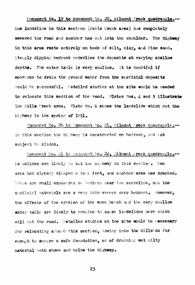
r onumeot No, Ja9 to o. 20. ill iltnont Creek guadrargle .-
One L-mdslide in this eccti on (J'alls Creek area) baa completely
severed the road a1 d anothe r has cut into th€ shoulder. 1'he highway
in this area resta entirely on beds of s i lt, clay, a .d fine sand •
.... t e ·ply dippin~ bedrock t~r.derlies the deposits at varying shallow
depths. T 1e -rmter tahl €· is very 9hallow. Jt is doubtful if
me::tsu res to drain the ground wate r from the Sllrficial deposita
·.·;auld lJ€ s ;cccssful. Petailcd studies at the site would be needed
to relocate thia section of thE> road. ?lates . oa. " and 5 illustrate
the Falls '~ reek area. Plate t o. b s hows the landslide which cut the
hi rmray in the sprin ~ of l , 51.
no. 21, .ilmont :: reck auadran~Ylc .
L this s e c t ion t~ h:i : hvfr?Y i s constn:c1.~d on he rocl, t~ r.d r ot
s ui j ec t tr sl ides •
. :onu.t"nent No. ~1 t io. 22, "l';i!J:lOnt l.reck quadrant;l e .--
l .a ~ dslides are ilkul , to c ut tiJt.: hir nway in this 8(:c t.i o r • ne
area haD already slt.·mp ~d o to t ' fee t, and a other area has cracked.
1 h ; ;'(1 are small e.xposn•f:S 0 1 ·. <·: d r c k ne iU' tr <-: shoreline, anc the
S ~l r!'i ci a l ::tatcr \.als are a 'Tery thi n veneer over bedrock . . ~owever,
t ne effec ts of the erosion of t he w v e bench a1 .d t he very s hallow
water t abh : arc likely to coroine t ca~se landslides h+: r e ;·;bich
will (; t the road. 'Detailed studies at the site ll)uld be r,ecessary
f or relocating a :-ou r d t.his aecti on, movin..,. i nto the hills i.de f ar
enough t o s cct.:r e a safe fomidat1on, or of dralni :1 wet ~ilty
material . oth abov e and belnw t he highway.
23
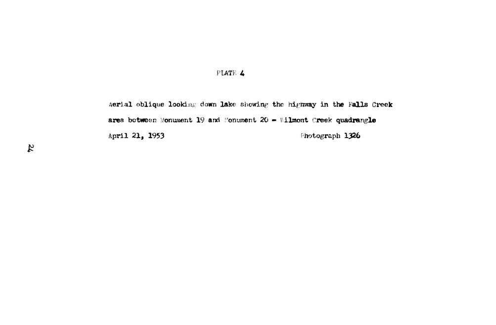
PLATE 4
Aerial obliqtle lookin ~ dt>wn lako showine the hit:hmly in the Falls Creek
area betwee n . onwuent 19 and :•onument 20 - ~·, ilmont reek quadrangle
April 21, 1953 ~h~togrnph 1)26


Pl<1 t e 4
Aerial oblique looking down lake showing the highway in the Falls Creek area between Monument 19 and Monument 20, Wilmont Creek Quadrangle, April 21 • 1953
Photograph 1326

PL 1.1'C. 5
Aerial oblique look · ne up L!!ke shcnring the highway in ti'Je Falls Cre ek area
betwen Monu:nen t ll) and 3ooument 20 • \':iJ.mont CrePk quadrangle
Photograph 1361

A e ria 1 obliqu e looking up 1dke sho,ving the highway in the F :1 lls C 1 eek a rea. betwe en M onum e nt 19 d nd M onument 20, Wilmont Creek U u ad ra n g 1e, May 6, 195 3
Photograph 1 361

· LA'l' 6
f..a n.isllcle wi:i.ch Cl.t tli E.: tway ·· n spri nr oi 19_1 in th_ t · all::~ · ree k art>.a
~)etv;e cl! ·:on ·1.c :· t 19 and ~ 1on · ... ~n ~ 20- : jlmor:t Cref·k quacl ran,rrlc
''ay l b , 1951

Plate 6
Landslide which cut highway in spring of 1951 in the Falls Creek area between Monument 19 and Monument 20, Wilmont Creek Quadrangle, May 16, 1951
Photograph 293

l!onument No. 22 t o J oz:UJ.ne nt lo. 2) 1 ~ilmont Greek quadr angle,_-
:o l andsl ides r e lated to t...:Mc ~.oosev lt ar u likel y to cut or en-
dar!€e r t his se c t i on of hig lnrciy. :. :...c of t hi s ::ltretc.h r \.. 3t s o :1 or
cuts int~ beds of s .i 1 t a :·,d clay . ome of t e cuts s how sr:!B.ll slides.
a · -<.1 t tJf n;: a r s teep s lopes in thr· fi l ls or cl.ts , :.t:t ... t : s :! ot l i ke l y
.. o . 2) to · ilmont cr ef:k guadra . ,. 1~ •. -
' e tvPPr~ thP-SC monu;ne t s th~ h ~ _:- lT,v:ty crosses be hi , c! t 1c a l crr.rc o ' a n
a ncic:1t la .-.<ls lid<' , pa r t nf -,·th i c h was f o::ned richt afte r t he .Sa n
~ .' 1P ' r-!p(l ::; i t r; of silt .1 :.d cJ. :--.y ~ .. hnt fi ll -4.:-1e r o r.l: oa s ·n ::oehinJ the
-: lo:;c a , ·. : • t .1 ... ~ ·C: k ld.ll t o ~ · ;c i c: t . ~. · s J J. ll t- L. .,, ~ ·;r:--..o: • :i t ·~ c-::u rs.
" onune: ;t ·.o . 24 t o
~ t :s r •... t expecteu that- t. e re '"' : ll )C a r:y la: .d~ l .; d · s c:u 1s d by ra ke
r. ~ . he
.. ~~:hway i n t .i s area cr os se~ ...
-. rt f · .-'la t 1 ·,y; · c h :.a thicY- 1 deep
a nt mtr1 cla:; fi ll. ·:-hore a re l ·c1r. .. '1 ~ r.i "• t slides in thi ~ a rea , a nd
a sh rt di s ta.: :ce . .;; r om s t .dy of t ~ 1e s lope chara cter .: s · cs, lo d
f ac t ;lrs, a n· i:;r ot:. :-x.i 't'iater ~oml.i ti ons, it s eoms r a t lt(> r ' oubt f ul that
there w-.ill 'be re •1ewed lands l ide act i ti t y in t his area.
:onument i~ o. 25 to ~iomune ,t ·Io. 2o, t:ilmont creek quadrangl e .-
n this area t he hie hway ski rts "i ncmile 3ay. Large lar.dslldos
have complet.ely cut the road i n two places, and a small one has
partly cut it . 1hroughout this s ection the road rests on alternate
sec ti ons of crz·an · te bedroc k , beds of nconsoli e!a t ed silt ;md clay,
ar : ~ s i lty s lope rmsh . ne pl a ces ·. d.ch ar . {;n tirely on bedr :-ck
are safe, J1:t t Hey ac co unt 1nr l ess t- i tan )u p~.. rc t: .. t 01 tne sect· 01.
A.J·..: n :ional ~ liain£ can t)( (: X[le cteu, :,a detail d site stu.a.i c~ would
t.. c n~ <;( e...;, • · rc..:l . ~a "Ll.on .
-c. i , c .... .:.. :.ce a u ul"l.slic:lc on J uly J, 1 '144 {s ee l-1 • .No. 7) . ! late :.o. 3
s ho s t.he s a. :-c slia\J i r. czy 1':1:>1 . 1 late ~m . lJ s rtows a slide or1 ich
c u i t he ni , hway i the 'l'fi nter oi l '-; )2 .
,;onume r, t o. 2o 1 i.i l r:.ont '~ ro · ~ qvaJr;wJ•le, to &:om;.ment • o. 27 1
l.i ncolr. gua ur ;ill p. l e .- ~ .. "i!mi.n.;:· a t . on ume t. ~ · o . ;.!u t: c nig tma:r ;d.nds
over a r!.ounta i. 1 to :.:!. .x;rjJ r"; r c ek a nd the :. 1 ollows a lm-1 terrace to
' on ur:~ nt :.o . 2'7. ,\J.l .Jf the n-:atc .r ial s expose-:1 along t.h~.s secti on are
coarse sands , [,ravols , a • .d !_,ol- l dE:rs , rei th sil ty sat ~d ap!:earillf, in a
i'ew spots. lhc hi ) may i s · ery close to the 1a e where i t makes
sharp t ur :1s around ~ .ixmile and l .ttr(:• filile creeks. .:)mall f · ilures
c oul.a occur at these two points, l. ll t t ie likelihood of major land-
sliC1es are rcla ~ . ively small.

~ I ATt, 7
J uly J, l '-J4
and ·onn~.ent 26
J uly u., l <J/.,.I.J l'hotogr a ph 21~

l· J 1 l L -
J.:~.n d :-. li d · at '~ i m·rn i l c •-..: r eck wh i ch c omplete i y cut hi g hw 3. y on J u ly 3 , 1949 - Wilmon t Cre~k Guad · , n ,d f' be twe e n l'-.1onu m - nt 5 ~tnu lv-\ onum e nt 2. 6
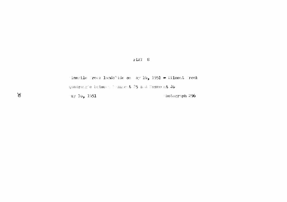
i-LAT 8
l ne;r i l u ·r <? ·k l arli:J' i. d t' on a;r llJ, 19)1 - i'.ilrnor.t ·r eck
:1!l8•:1 r .l t.,ic-:' e ·c twe:. ·. · .1u:.(· .t :? 5 3 . d :· o~n.l• n t .26
a y lo, 1<151

l\i inem il e Creek L.:tnds lide on Md y 16, 1951- Wilmont C re ~:::k WUd d r ...t n g l e between onum t·nt 2 5 ...t n d M onume n t 2 6
I ' l.ile ~. 1- holo g r . .1p h 29 G

f'}. ':: i ' . ')
:·a:r 10, 1953

PL.ttv 9
-
LanJ .s liJe ju st s outh of N inernile B ay which severed hig hway in the winter of 1952-./ ilm ont C r et:k u u..~. d r .:.~ng le b e tw e e n Monum e n t 25 a nd Monum e nt 2 6
I-' hotogr<iph 1341

... onument o. 27 to :.•onument 2<i , J.ncol:-1 guadranr;:l e .
The hi1rhw y in thi s s ecti on f olloYrs alonp the edt;c of terrae1e
dep\.1si ts of sllt a ·td clay. The wa t er 1:-'lbl e is veiJ' s h.allnw.
H wr e a~ spri ,- s a bovu the rnad. ,) exile sli::ies are deve l r:ping
be be· t n z -Jd ·,a t; e l a ke , and 1 iu s s e c t i on is t hrea t · .. ,·,ed.
'f! ,c :·e are a i cw s .. · 1 local . cd r c~ points bet they ac cou:.t for
les ~ t l1a. 20 perce 1. t o1 the roao 1. o 1 :.da t i o : . :. ono pl ace a slide
in Hl<~ s .~. lt a:.· cl y as f lowed a rot.. Leer' c k points. r etailed
stu.u..Le:.. at t:. JI . ~ii. tt: ~ ; ul~ bu n:q _;_ ,Ct-!O a s 1:l :.- a::t 1. S l ·or c l tl1 r re
locati:<_~ or dr aitJ.ng this s t.:c ioc .

lan islid ' r <; has e c- , a f ·at ·1L ~-~ t!10 up:'c·r r. ol umui a ·liver
!a ll y s ) ce r:lacial Urnes. ; he a:·c ·leration 01 slid.ir ~· in rec ent
y ear , llcco;;,panyi , t e i llint: of ! .:1:-:e oosevel t aLd St!bseqw:. nt
f l uc t .... atiorw in tne reserv oi r l eve l , h: s proviucd a \ ; ~ .ique on;.ortu"li ty
10r ;:: olo .:t~c s t c:lly oi l..:.llldsl .ial ·s . ~ ~ ~e ;_:-eoJ. o,- l.c .. :li.-e r l J.l s involved in
l · ·· e s a .·e t ile I CO:!solia.att1d S.~r.: o~ i t.s ·. 1" . l a ..; · al or ·gl.r. that once
1 l lctl tll ;.iolirock .:, argo ol" t :<.. ol' t: ~ ·ia LV£! L·, a d w!l lSe rem: :az t.s
co1 1Bt.~ · t tlle casit~t l "JL.tes oJ Lr avEl •i•·d t.Jw ap~re :-. tly zr..ost
O.es .;.r d 1 s i teo ..;. Ol' devcloptaen t. :) f t.i1 ' la e s hore . .et.enn na tio11
of s aic..: areas , a •:d areas oi' po w . t i a l s li :il · Ls baaed on obs erta tion
0 1 t 11C .:.JL.r : o1· t ho ~ cor ··o litiat<·· S L·IIi::tc:1ts , t ne local ;~osj t J or: of
t1 e w tt r t a :: l t· , t ;.e pas .:.. t _o:: a J s t a pe . ol :.i c: ~e ri :~d bt.dr. c k :; ~ :r;acc ,
a: : l n !1e : .. ~h t . : u ste t p . . ss 1 L ~ . e pce s<.: :· t slope 01 th .r conaoli a ted
a .pos , ts , • oth t ;u ! s · t;: · ~n·c .ed port: o··ts a . d t.r1 ,s <> a bovl" l a k l eve l .
!"J.s rerto t· i:. dcscrib s l .:t :J .... ~ id e c on<.ii t ~ons al ·~ r :f- t he hl ._;hway
·.r.i c t1 s Kj . · ~.o t i" E' west s n·H·e of t. ,.:· rese rvo i r i n l· e r ry l ow ty · ·etwecn
··e t Ll e •c:t :i..l s h r iuge a ;. a poi . . :. <J . ·• on i tR t 10 mout; r,J t he ~ poka ne
i v E:r . ','' !lc 1 er ry ot.n t .:r . i ·~ llYi<! ' : '18 L -· n omplt:: t ely cut by l and
· l l !J.65 in !1 · places . lr ; LJ L: .,f.•,-i l.£!rracc a :.u , :u ls t; reck areas ,
t.u •. pol·ary reloea t ~ on..s <i'l e l; ):r ov i ,.cd . 1.a:-.ds lid<.. ac t:.vi. ty i n t oo
.l nomil€ area n s poseG ~t.ch .•lL Cl.!l t ' l.L cxp '! r!i 1 v . n "' local l. on
...,robl e ms t nat tlt hi~ .1ro.y r as beer . Cl•)BCC lOS t of t:·,e: t i.. o sincl'
Jf t 10 '15 .u) n:.il c s ,f hi l•Vl3:· in t he area oi' Ltlis r e port,
1;> . 2o miles are ill a nge c of ~einr~ ;·l:utl y or y;" olly \lr:stroyeo by
l and .. l ides or wave ac i oz , a · .-1 bl .. '19 r.J. l e s ap· ~car t r- ,)e safe .
3;
uret~ , ,J • • 1 192 31 Glacial draj na:;:-e on tiu:: (' ol um.bia 'PL-1 tea u :
c.eol. Soc. America '!ull., v. 34, P• S?J.
Culver, H. : .• , 1936, 'I'hc geolo1:y of ,·•a s h.in;,.to :., Part 11 Gc:.eral
f eat res oJ· \, ashin · t on ge c; lo f:y : ::ashing t N1 Liv. i.;eolot;y
;'1;.11. .32 •
l·lint, :: . r ., l , JO, J tratificd drift a: d der;l aciat ion 01· eastern
l .aah i n&ton : veol • .J OCe Amerl ca .~ull., v. 4? 1 >:o. 1.21
p. li 4~1- U4 .
-----' lYJ ) , ~lac '. al fea :. .rus 01 t hu n H ther r: ka .oga r~~r_ i o . :
.- .eol . .... oc. -' r..erica t..ll., v. 46, ~ ~o. 2 , P • lu9-1'14.
-----' a r d rwi n , \ r • H., 1';)39 , · lacial P, ol.-.gy of . .ir <!r .J Coulee
.. : des) :Jc r y, 1no;z , ;-, O\•tlil•t• of ~cc:lo:zy of · a shin .-~to;; :
.eol. <1 t:rv.y (V cti . :;pt., Jt . 1.
&S l1inr to n
·: alke , ;· . L., a:1d Irw-in, .: . il ., 19 52 , J.a; ds l l ues a : .d c : .~:). n· <:rin~:
problen e i n t ho l'es .lC l om var-: c~d clays of th · • olut .i,ia · d.ver
··.as ; , : Pare r prese r:ted at 1e ~ ~ nte : ~1ial ·o Jj ·r.- c n. t: on of t he
. merl e a il 3oc. i il I n~;rs., ... hlca,- ·o , . llinois.
, eaver, --: . ., l ':J l0 1 ~~0o lug.ical histor y of . asnil"lt: t. J . · ;ol·thwest
O t. ~ ·· !ool' , ; . l.
J4
1920 1 'i'ho mineral r so · ··ces of .... tever s couc1ty,
:'.ashinetoll : ~ ~ a.shi · .~o:: ucol • .Jurv 'Y ·:ull. ;,.o.
·. illis, dailey, lt;,,? , C ha:.t~ s i . . r i /<!r courses in . , a~•hingtoJl ! ·cr-
ri tory due · o t;l a ci ation : [, ...... ...s l!Ol. ·' Lrvey ...; l:ll. 401 p. 477-
480 .

.......__ ---....
,.._____/
JO
t5'
0
"'
:lles:;Jelem
f. (
/
4.:
--'
~- --/
I<J \!)
2: "0 <t Q::
0 ~ Q::
w
---~ > (;
(T ,_
-~ LU ,._.
..J ~
t-w lC
; ..,m L o /fes
GE NERAL LOCATI ON MAP
Ferry County Highl90Y Por~lel ing L~~ Roosevelt I I I II I I
!.files
>
w
-
- - - - -- -- ~ 0
. • ..151.
, 0 ~s·
( .')
0 •
..
•