Embed Size (px)
Citation preview
1
Geomorphic Context, Constraints, and Change in the lower Brazos
and Navasota Rivers, Texas
FINAL REPORT September 2006
Jonathan D. Phillips* Copperhead Road Geoscience
720 Bullock Place Lexington, KY 40508
*Also Department of Geography, University of Kentucky
Submitted to the Texas Water Development Board
2
PREFACE This report is submitted in fulfillment of contract no. 2005-483-564 between the Texas Water Development Board and Jonathan Phillips (doing business as Copperhead Road Geoscience). The report is presented in two more-or-less independent parts, reflecting the Scope of Work for the project. The first is a review and evaluation of geomorphic stream channel classifications in the context of the Texas Instream Flow Program: Geomorphic Classification, Geomorphology, and Water Resource Management in Fluvial Systems: The Texas Context. Part 2 is a geomorphic assessment of the lower Brazos and Navasota Rivers, based on application of River Styles. Part 2 is presented in several subchapters. Each part has a separate list of references cited.
3
TABLE OF CONTENTS Part 1. Geomorphic Classification, Geomorphology, and Water Resource Management in Fluvial Systems: The Texas Context 6 Introduction 6 Geomorphic Classification Systems 8 The Texas Context 14 The Equilibrium Problem 17 References 19 Part 2. Geomorphic Context, Constraints, and Change 25 Geomorphic Classification of the lower Brazos and Navasota Rivers 25 River Styles 25 Study Area 26 Methods 28 Environmental Context of the Lower Brazos & Navasota River Basins 30 Introduction 30 Climate 31 Hydrologic Regimes 31 Geology 35 Landscape Units 37 Human Impacts 39 River Styles Classification 41 Overview 41 River Styles Key 42 River Style Descriptions 44 Reaches 58 Trajectories of Change 61 Introduction 61 Discharge 61 Cross-Section Morphology 61 Planform 63 Base Level 65 Sediment Transport 65 Causes of Change 66 Summary 67 References Cited (part 2) 68
4
Appendix. Scope of Work 71 LIST OF FIGURES Part 2, Chapter 1: Geomorphic Classification Figure 1. Study area. 27 Part 2, Chapter 2: Environmental Context Figure 1. Brazos River basin. 30 Figure 2. Reference flows. 33 Figure 3. Specific mean daily discharge. 34 Figure 4. Landscape units. 38 Part 2, Chapter 3: River Styles Classification Figure 1. Reaches of the lower Brazos River. 59 Figure 2. Reaches of the Navasota River . 60
5
LIST OF TABLES Part 2, Chapter 1: Geomorphic Classification Table 1. Gaging stations used in the study. 28 Part 2, Chapter 2: Environmental Context Table 1. Reference flows. 32 Table 2. Flood regimes. 35 Part 2, Chapter 3: River Styles Classification Table 1. River syles classification of study reaches. 58 Part 2, Chapter 4: Trajectories of Change Table 1. Geomorphic changes and research priorities. 67
6
PART 1
Geomorphic Classification, Geomorphology, and Water Resource Management in Fluvial Systems:
The Texas Context
INTRODUCTION Geomorphology—encompassing landforms, channel and valley morphology, processes of erosion, transport, deposition, and bank failure/stability—is vital for the management of river and stream systems. River engineering, aquatic and riparian ecosystem management, and water resource management all depend on characterization and understanding of fluvial geomorphology. In response to these needs a number of river and stream classifications and characterizations based on, or incorporating, geomorphology have been developed. The purpose of this paper is to review the geomorphological basis of classification and
7
characterization schemes, and to evaluate them with respect to two criteria—relevance to instream flow assessment and management programs, and appropriateness for application in the Texas coastal plain. Geomorphology, Classification, and Water Resource Management The most obvious differences between fluvial systems—or different portions of the same fluvial system—are geomorphological. Aspects such as channel width and depth, bank type and steepness, floodplain morphology, slope, bed and bank material, valley wall confinement, etc. are clearly critical not only to fluvial geomorphologists, but also to river engineering and to any human access to or use of river resources. Fluvial geomorphology also affects, and reflects, hydrologic processes and regimes. The type and quality of aquatic and riparian habitats are also directly related to specific landforms and geomorphic processes (e.g., Hupp and Osterkamp, 1996; Scott et al., 1996; Robertson and Augspurger, 1999; Johnston et al., 2001; Gumbricht et al., 2004; Moret et al. 2006). There is little or no dispute of this contention. Statements such as Montgomery’s (1999), for example, that “spatial variation in geomorphic processes governs temporal patterns of disturbances that influence ecosystem structure and dynamics,” have never been seriously challenged. Evidence showing specific relationships between stream geomorphology and aquatic macroivertebrate habitat quality, densities, and diversity is presented by Sullivan et al. (2004). The widespread acceptance of geomorphology-based classification systems by ecologists, hydrologists, and water resource managers is evidence of the general realization of the critical role of geomorphic properties for essentially all aspects of river systems. Assessment of stream condition from a distinctly geomorphological perspective has many benefits to river managers, according to Parsons et al. (2002), including: •an ability to characterise and explain river behaviour at different positions within catchments; •predictive basis to assess future river character and responses to disturbance; •basis to determine suitable river structures to support viable habitats along river courses; •guidance to develop pro-active, rather than reactive, management strategies, setting realistic target goals in development of river/catchment management plans and more effectively prioritorising allocation to management issues; and,
8
•an ability to be used in programs to assess and monitor river condition. The role of fluvial geomorphology in channel habitats in the context of river management is discussed by Newson and Newson (2000), who emphasize the critical control exercised by geomorphology on physical habitats. Newson and Newson (2000) describe the challenges of integrating geomorphology and ecology, and of incorporating a distinctive spatial formulation and biological validation into studies of interactions of fluvial geomorphology with biological habitats. They also note the lack of “a truly geomorphological channel classification, based on reaches, into which mesoscale habitat typologies could be fed” (Newson and Newson, 2000). Geomorphology is also critical to classification, delineation, and impact analysis of wetlands. For example, U.S. government agencies charged with wetlands regulatory and assessment programs have adopted an explicitly geomorphic/ hydrologic approach to wetland identification and characterization known as the Hydrogeomorphic Method (Brinson, 1993; Johnson, 2005). Texas Instream Flow Program Instream flow programs (IFP) are intended to balance human and non-human uses of water, the latter typically summarized in terms of ecosystem requirements. IFPs are typically instituted to assess surface water withdrawals and flow modifications with respect to flow regimes required to maintain aquatic and riparian ecosystems (and sometimes instream recreational and economic activities). As a National Academy of Sciences report put it, IFPs “are being developed to answer the often politically-charged question, ‘how much water should be in the river?’” (NAS, 2005: vii). The Texas IFP has its roots in legislation establishing a state water planning process which considers environmental values in water development and allocation. The Texas Water Development Board (TWDB), Parks and Wildlife Department (TPWD) and Council on Environmental Quality (TCEQ) were directed to jointly establish and maintain an instream flow data collection and evaluation program, and to determine flow conditions in Texas streams necessary to support, in the words of the enabling legislation, “a sound ecological environment.” Priority studies are due to be completed no later than 2010. The IFP programmatic work plan and technical overview developed by the three agencies are available from http://www.twdb.state.tx.us/instreamflows/. The National Academy of Sciences established a �”committee on review of methods for establishing instream flows for Texas Rivers,” which published an extensive review and recommendations (NAS, 2005). The review found that the
9
existing technical overview document was “notably brief” in its discussion of hydrogeomorphic processes, “compact in its discussions of river classification, assessment of the current status of a river in terms of its geomorphology, and sediment transport processes,” and “only scantly mentions some general methods that can be employed to assess and measure physical processes in an instream flow study” (NAS, 2005: 60). The NAS review explicitly addresses the issue of geomorphic classification, noting that classification “is an important component . . . useful for documenting and analyzing physical processes, for selecting representative reaches and study reaches for instream habitat analysis, and for water quality analyses” (NAS, 2005: 71). The report also recommends identification of the river’s geomorphic equilibrium status as part of a geomorphic classification (p. 72). GEOMORPHIC CLASSIFICATION SYSTEMS A wide variety of geomorphic classifications of river channels and fluvial systems exist. Given the comprehensive recent reviews by Kondolf et al. (2003) and Parsons et al. (2002) there is no need to review them all here. Some of the more popular, influential, and representative schemes are discussed below, in approximate chronological order. The classifications reflect intended purpose, background of the developers, and the rivers or regions in which they were developed. The underlying philosophies of classification reflect opposing views of rivers as continua or discrete types. “As applied to river classification,” Kondolf et al. (2003: 173) write, “the issue boils down to whether river systems are composed of a continuum of channel morphology or discrete types of channel either bounded by geomorphic thresholds or controlled by local influences . . . . In the latter case, it may be possible to develop a natural classification, while in the former case, all channel classification schemes are perforce arbitrary, special classifications.” Kondolf et al. (2003: 177) also distinguish two main objectives for classification; either scientific understanding or geomorphically-based guidance for channel management. Hierarchical Continuum of Sensitivity Frissell et al. (1986) used the concept of proximate and ultimate geomorphic and biotic controls, along with hierarchy theory, to hypothesize a continuum of sensitivity to disturbance, and of recovery, in stream systems. The scheme is based on a hierarchy of spatial scales from microhabitats to watersheds. Microhabitats are the most sensitive, since local disturbances within the microhabitat will influence them, along with disturbances of the encompassing
10
habitat, reach, segment, stream, and watershed scales. By the same reasoning, watersheds are the least sensitive (Frissell et al., 1986). The hierarchical scheme of Frissell et al. (1986) was an important conceptual advance in river classification, but does not provide a classification tool useful for management applications (Naiman, 1998). Frissel et al. (1986) argue that their classification is useful only for temporally stable features—that is, once classified, the features should not change over time scales of years to decades. Thus it is not applicable if one seeks to capture the dynamic nature of fluvial features. The Frissell et al. (1986) hierarchy (and other classification schemes using the same conceptual basis) are top-down in the sense that the broader scale is assumed to control the underlying levels. Heritage et al. (2001) observe that when such an empirical hierarchy is imposed on different rivers “the structural rigidity . . . prohibits the hierarchy’s meaningful use on rivers of a different nature” from the one for which the scheme was originally devised. They favor instead a bottom-up, agglomerative hierarchy relying on the specific morphological associations of the river under study (Heritage et al., 2001). Genetic Classification of Floodplains The genetic classification of floodplains devised by Nanson and Croke (1992) recognizes three classes:
(1) high-energy non-cohesive (2) medium-energy non-cohesive (3) low-energy cohesive
The scheme has 13 sub-classifications based on nine factors, chiefly floodplain-forming processes. The classification identifies distinctive geomorphic features which are linked to systematic differences in floodplain origin and development (hence the “genetic” classification). This classification is limited, however, by its focus on a particular part of the fluvial system (floodplains). Other classification systems are similarly limited in application only to particular types of fluvial systems (e.g., anabranching, Knighton and Nanson, 1993) or to particular geographic regions or environmental settings (e.g. Montgomery and Buffington, 1997). Rosgen Classification System The Rosgen classification system (RCS; Rosgen, 1994; 1996a) is a well-known method for classifying rivers and streams based on channel morphology. The method is widely used for various assessment and management purposes by a

11
number of federal agencies, including the USDA Forest Service, Environmental Protection Agency, and U.S. Army Corps of Engineers (Kondolf et al., 2003; Naiman, 1998). A number of state and local water and natural resource management agencies also use the RCS. The Rosgen scheme is a four-level hierarchy. Level I classification is based on characteristics related to landscape relief, landform, and valley morphology. Level II provides more detailed description based on field measurements of channel form and bed composition. The stream condition and stability is evaluated in level III, and level IV involves field measurements for verification. While recognizing the RCS as a useful communications and standardization tool for professionals working with stream channel management and rehabilitation, Miller and Ritter (1996) strongly criticized its used as a predictive tool (see also response by Rosgen, 1996b). Beyond the specific critiques of Rosgen (1994), Miller and Ritter (1996) identify several more fundamental problems with the use of the RCS as a predictive tool, involving unsupported assumptions about the relationship between stream types and geomorphic equilibrium, lack of linkages to hydrologic and climatic regimes (and one might add recent sea level histories, tectonic regimes, and other environmental controls), and the assumption of a one-to-one relationship between forms and processes. These shortcomings can be problematic in practical applications such as urban stream restoration, as illustrated by Niezgoda and Johnson (2005). Naiman (1998) notes that the RCS (and other morphological classification systems) “do not provide the level of understanding of channel processes needed to predict channel responses to . . . disturbances” (114). Caratti et al. (2004) tested a multivariate watershed classification based on canonical correspondence analysis based on its ability to predict Rosgen stream types. Similar results were obtained with the use of an organized classification using variables expected to have statistically significant relationships with watershed properties, and with a random distribution of environmental variables from the same data set. The authors interpret the results as indicating that the multivariate analyses do not necessarily select meaningful variables from a broad spectrum of data (Caratti et al. 2004). An additional or alternative interpretation is that there is not necessarily a direct relationship between watershed environmental controls and the stream channel/valley bottom characteristics represented in the RCS. The bank erosion potential ratings of the RCS were found by Harmel et al. (1999) to be poorly related to measured bank erosion in northeast Oklahoma, though a channel stability rating and near-bank shear stress estimates were also poor predictors.
12
Savery et al. (2001) determined that the RCS could be applied to low-relief streams in Wisconsin. However this study, along with Epstein’s (2002) study in the New Jersey Pine Barrens, illustrate the need to modify the system to accommodate local and regional conditions. This, along with Hassan et al.’s (2005) assessment that useful classifications of forested headwater streams are oriented to specific purposes, indicates that even where RCS or another classification system is used, a firm adherence to existing categories and criteria may not be effective. The RCS has become well-entrenched in the U.S. as a basis for stream restoration and rehabilitation. Unfortunately, there has been little post-project assessment of rehabilitation efforts in general (Kondolf, 1995; Kondolf et al., 2001). The inconsistent performance of such projects has sparked debate over the use of the RCS and morphological classifications in general for channel design and restoration goal-setting. Kondolf (1995) specifically addressed some of these issues (for the RCS and channel classification more generally) in the context of aquatic habitat restoration. He noted the problems with creating arbitrary classification units from a continuum of channel types, and the tendency to confuse the classification exercise with understanding channel behavior (Kondolf, 1995). Smith and Prestegaard (2005) monitored a Maryland rehabilitation project in the context of these issues, finding the recreated channel to be unstable. The findings indicate a need to evaluate relationships between channel stability and hydraulic conditions over a range of flow conditions and spatial scales, rather than using a morphological template such as the RCS and a single design flow (Smith and Prestegaard, 2005). Similarly poor results were found in a California stream by Kondolf et al. (2001). In their review of geomorphic classifications, Kondolf et al. (2003) consider the RCS and form-based classifications in general to be poor bases for channel design and rehabilitation. Form-based classifications in general and the RSC is particular are limited by time-dependence (e.g., lack of dynamic or evolutionary component), uncertain applicability in different environmental settings, the difficulty of identifying a “true equilibrium condition,” potential errors in indentification of bankfull elevation, and the fuzzy relationship between the classification criteria and geomorphic processes (Juracek and Fitzgerald, 2003). Juracek and Fitzgerald (2003) recommend against use of the RSC for purposes other than description and communication, such as assessments of stream stability, inference of processes, prediction of channel responses, or guidance for restoration. With respect to IFP’s, the utility of the RSC or a similar system would depend on the extent to which morphology represents “equilibrium” conditions (itself a
13
problematic concept to be addressed below) that are in turn attuned to dominant flow regimes. The work of Juracek and Fitzgerald (2003), Kondolf et al. (2001), Miller and Ritter (1996), and Prestegaard and Smith (2005) casts doubt in this regard. Segments, Reaches, and Units A hierarchical classification system was developed in the Pacific Northwest in the early 1990s based on valley segments, stream reaches, and channel units, and disseminated more widely by Bisson and Montgomery (1996). The geomorphic basis of the system is described more fully by Montgomery and Buffington (1997), though the latter is focussed on the channel reach scale of the hierarchy. The Montgomery and Buffington (1997) system is process- rather than morphology-based, though morphological indictators are (inevitably) used. Variations in bed morphology provide the basis for a classification that reflects channel-forming processes, illustrate process linkages within the channel network, and allow prediction of general channel response potential (Montgomery and Buffington, 1997). The classification is linked to a specific underlying geomorphic hypothesis; that alluvial bed morphology reflects a stable roughness configuration for the imposed sediment supply and transport capacity. Channel reach types are associated with ratios of transport capacity to sediment supply, external influences, and the spatial coupling of channel reaches with hillslopes and other channel types. The classification system outlined by Bisson and Montgomery (1996) and Montgomery and Buffington (1997) has not been applied beyond mountain streams in the western U.S., and is not useful for floodplain rivers (Montgomery and Buffington, 1997: 609). Further, the assumption that bed morphology represents a stable roughness configuration is not always valid. However, Montgomery (1999) explicitly addresses how geomorphic process domains based on this hierarchical system can provide a framework to address patch dynamics in stream ecosystems. River Habitat Survey River Habitat Survey (RHS) is a system for assessing the habitat quality of rivers and streams based on their physical structure. RHS is widely used in the United Kingdom, for example by the U.K. Environment Agency (Raven et al. 1998a; 1998b; Environment Agency, 2003). The RHS is specifically linked to geomorphological bases for river classification by Newson et al. (1998).
14
The RHS is based on a standard field survey method, the results of which are integrated with a database from more than 17,000 sites in the U.K. Relatively undisturbed reference sites allow comparisons to reference conditions and intercomparisons of sites of the same type. The classification is a five-class (bad to excellent) assessment of the deviation from the reference condition. The RHS is based on a view that habitat is a result of predictable physical processes, and thus measures variables representing the character of stream habitats assuming that these variables reflect the geomorphological processes that are acting to form those habitats (Newson et al., 1998). Geomorphological theory underlies many of the variables collected, but the RHS is not strictly a geomorphological survey and specific measurements of geomorphic process rates are not considered. While the RHS has several advantages for linking geomorphic stream properties with habitats, it is not practical to duplicate in Texas the database underlying the RHS system. Texas’ land area of 695,673 km2 is more than 2.8 times greater than that of the U.K., and encompasses a wider variety of hydroclimatic regions. Stream Power Stream power, reflecting the aggregate erosional and sediment transport capacity of stream flow, is recognized as a key determinant of fluvial forms and processes. Stream reaches and classes (or critical boundaries and transition zones) can be defined based on downstream variation in stream power (Knighton, 1999; Jain et al. 2006). Stream power also plays a role in more comprehensive river classification or characterization schemes, such as those of Brierly and Fryirs (2005) and Montgomery and Buffington (1997). Stream power-based classifications must usually be supplemented with other geomorphic variables, and power is not independent of slope, which in turn is not independent of other morphological parameters (Kondolf et al., 2003). If the latter dependencies are accounted for, stream power is a useful variable in classification, but not by itself useful for general classification purposes (Kondolf, 1995; Kondolf et al., 2003; Newson et al., 1998). Quantitative Taxonomies Several approaches to geomorphological classifications of fluvial systems have relied on objective or semi-objective methods based on using statistical techniques to derive or detect clusters or groupings from quantitiative data. One example is Heritage et al. (2001), who use these methods to derive a
15
morphological classification based on agglomeration. While this study obtained good results on the Sabie River, South Africa (Heritage et al. 2001), other studies have yielded poor or mixed results (e.g., Caratti et al. 2004). In general, this approach is too data-intensive for widespread application in management contexts.
River Styles The river styles framework developed by Brierly and Fryirs (2005) is not a classification scheme per se, but a flexible, dynamic approach to river characterization. The lower case term river styles (or RS) will be used here in reference to the basic logic and scientific approach espoused by Brierly and Fryirs (2005), as opposed to the trademarked assessment algorithm, indentified as River Styles™. RS, in contrast to a categorical classification scheme, is specifically intended to incorporate evolutionary pathways of the fluvial system, rather than static conditions that are presumed to be related to stable equilibrium states. Rather than geomorphological taxonomy into which specific features are categorized, RS “provides a geomorphic template upon which spatial and temporal linkages of biophysical processes are assessed within a catchment context” (Brierly et al., 2002). RS was developed as a research tool by geomorphologists working with the New South Wales (NSW, Australia) Department of Land and Water Conservation. It has been applied in NSW for a variety of river management applications, including rehabilitation programs, aquatic and riparian habitat assessments, and prioritization of rare or unusual features for preservation (Brierly et al., 2002; Brierly and Fryirs, 2000). The ecological significance of the river styles framework was specifically assessed by comparing macroinvertebrate assemblages and habitat characteristics of specific geomorphic units for three different river style units in NSW (Thomson et al., 2004). Statistical analyses showed that macroinvertebrate community structures varied significantly between between two of three styles examined, but differences in the third comparison were less apparent. Thomson et al. (2004) attributed this to local-scale variability in one of the styles (meandering gravel bed rivers) and suggested that integrating RS with other broad scale variables reflecting stream size, temperature, and hydrological regime would produce a more effective classification. One of the co-authors of this study, incidentally, is a co-developer of River Styles™ (G. Brierly). RS is set within a nested hierarchical framework and incorporates assessment of river structure at the catchment, reach and geomorphic unit levels. Geomorphic units are analyzed and orgnized into reaches, which are amalgamated to form
16
source, transfer, throughput and accumulation zones, based on the assemblage of geomorphic units and associated sediment relations along reaches. Watershed characteristics are used to determine the nature of the controls on river character and behaviour in each process zone.The evolution of the river is then assessed in a historical context, and provides an indication of pre-disturbance stream characteristics. Lastly, the direct controls on habitat availability are assessed by analysis of changes to channel geometry and planform, the assemblage of geomorphic units within each process zone and the nature of altered associations that each of these geomorphic features have with riparian vegetation (Brierley and Fryirs, 2005). While RS is not a classification scheme per se, it can be used as the basis for categorizing specific fluvial systems. Despite its attractive grounding in geomorphology and river science, Parsons et al. (2002) note some potential disadvantages. These include assumptions that the units considered are relevant to biota (presumably a disadvantage to all classifications not based directly on biota), the requirement of a high level of geomorphological expertise, and the reliance on aerial photography and specialized field equipment. THE TEXAS CONTEXT The utility of any characterization or classification must be evaluated with respect to the intended purpose (in this case the Texas IFP), and the environmental context. Here, the latter is the lower Brazos River (including the Navasota) basin in particular, and the coastal plain reaches of Texas Rivers from the Sabine to the Colorado in general. The scientific and technical basis of the Texas IFP has already been reviewed by NAS (2005), who gave considerable attention to geomorphic classification issues. The NAS review recommends IFPs based on “natural flow characteristics” as a reference condition, and on adaptive management strategies. The former has traditionally been based (as has much in hydrologic engineering and water resource management) on a single design or reference flow. Increasingly, however, this is changing to consideration of a range of flows (i.e, a flow regime) that incorporates seasonal and interannual variability. Similarly, while channels have historicially been the focus, state-of-the-art instream flow science includes physical processes in riparian and floodplain areas as well as channels (NAS, 2005: 35). Classification of river segments is addressed in detail (NAS, 2005: 92-96), noting in particular challenges posed by flood-dominated rivers such as those in Texas to the west of the Brazos and Colorado Rivers. While this point is well-taken, the discussion is based on the premise that rivers not necessarily flood-dominated
17
are more likely to be in equilibrium, which may not be the case (see below). Further, while rivers such as the lower Trinity are not seen as flood-dominated in the sense that rivers such as the Guadalupe or San Antonio are, channel morphology in much of the lower Trinity still reflects the effects of a very large 1994 flood (Phillips et al., 2005). The report specifically questions the use of the RSC in the Texas IFP (NAS, 2005: 92-93. Assessing the current status of a river segment is enmeshed in any classification process, and the NAS (2005) study specifically recommends incorpation of indicators of recent and historical change (93). Environmental Context The Navasota and lower Brazos Rivers (along with the Sabine, Neches, lower Trinity, and San Jacinto) drain the portion of Texas with a humid subtropical climate and mean annual precipitation of 750 to 1300 mm yr-1. Watersheds are dominated by agricultural land uses (particularly grazing). Channel substrates are generally sandy to muddy and quite mobile, but in some cases bedrock is exposed, or covered by only a thin (<1 m) veneer of alluvial sediment. “Bedrock” is often cohensive clayey pre-Quaternary sediments. The coastal plain portions of the major rivers are meandering streams with evidence of active Quaternary, historical, and recent channel migration, and relatively broad, active floodplains with significant connectivity to the channels. The lower reaches are often characterized by yazoo-style tributaries representing former trunk channel courses. The valleys are inset into pre-Quaternary materials, with the modern channels typically incised into Pleistocene terrace deposits. The rivers of the region have experienced several episodes of cutting, filling, channel migration, extension, and contraction due to Quaternary sea level and climate changes (Alford and Holmes, 1985; Blum et al. 1995; Morton et al. 1996; Rodriguez et al., 2005; Waters and Nordt, 1995). This history is important in determining contemporary river behavior. For example, the Brazos River is incised into Pleistocene alluvial terraces, the elevation, morphology, and composition of which influence the modern river (Blum et al., 1995; Waters and Nordt, 1995). Morphological and process transition zones on the lower Trinity River, to give another example, are controlled by Holocene valley evolution in response to sea level rise (Phillips et al., 2005). Hydrologic Regimes
18
Hydrology is the “master variable” for instream flows, and geomorphology is a key component of classification not only for its intrinsic importance, but because geomorphic characteristics reflect, to varying extents, stream discharge regimes. The form and material of a river channel and its associated banks and floodplain arises from interactions among discharge, sediment supply and caliber, channel size and geometry, and hydraulic slope, velocity, and roughness, and is influenced by its geological and climatic context. The NAS (2005) review notes that “stream channels react to changes in sediment dynamics and either degrade or aggrade along the longitudinal gradient in response to sediment load,” but this implies an oversimplified view of both forcing factors and the range of possible responses. Texas’ IFP should be based not on any single reference or design flow, but on a range of flows (NAS, 2005). The NAS (2005) recommends an approach based on four criteria: subsistence and base flows, high flow pulses, and overbank flow. Base flows are the “normal” flow conditions between storms (and, presumably, droughts), while subsistence flow is the minimum discharge needed during dry periods to maintain tolerable water quality and refugial aquatic habitat for organism survival. High flow pulses are short-duration, high flows that serve to flush the fluvial system, and overbank flows breach river banks and inundate floodplains. NAS (2005) recommends that the Texas IFP incorporate all of these rather than a single reference flow. Implications for Geomorphic Classification Taken together, the needs of the IFP and the environmental context of the study area imply the need for a classification or characterization scheme which: •is not based on any single reference or design flow; •includes floodplains and riparian areas; •is based on links between hydrology, geomorphic processes, and channel/valley morphology; •can incorporate trends or trajectories of change; •is applicable to meandering floodplain rivers; and •is sensitive to geologic context, antecedent topography, and other manifestations of the legacy of Quaternary climate and sea level change.
19
THE EQUILIBRIUM PROBLEM Despite considerable evidence to the contrary going back more than 30 years (Callander, 1969; Stevens, 1975), geomorphologists—and even more so water resource managers from other backgrounds—have assumed that geomorphic systems in general, and stream channels in particular, are likely to be in “equilibrium.” Equilibrium is, unfortunately, variously and poorly defined in the earth and environmental sciences, despite several attempts to introduce standardization and rigor into equilbrium terminology and the identification of equilibrium states (Ahnert, 1994; Howard, 1982; Thorne and Welford, 1994). It is often implicitly assumed in fluvial geomorphology that, given sufficient time between disturbances or environmental changes, a fluvial system will reach a state of adjustment with a characteristic form, and that a dynamic steady-state will be maintained. This assumption is particularly common in applied fluvial geomorphology and hydraulic engineering (e.g. Biedenharn and Watson, 1997; Moret et al. 2006; Toy and Chuse, 2005; Wyzga, 2001). Several classification schemes are based on equilibrium assumptions of this nature, either with respect to specific features such as bed roughness (Montgomery and Buffington, 1997), or overall channell state (Frissell, 1986; Rosgen, 1994; 1996a). In many cases streams do maintain a dynamic steady-state equilibrium, but many do not, either because they are too frequently disturbed, or they are inherently unstable (Renwick, 1992). There is no evidence that stable, steady-state equilbrium stream channels or fluvial systems are notably more common or more “normal” than nonequilibrium states (Bull, 1997; Callander, 1969; Downs, 1995; Harbor, 1998; Hooke, 2003; 2004; Lane and Richards, 1997; Muto and Swenson, 2005; Phillips et al., 2005; Seminara, 1991; Stevens et al., 1975; Thornes and Gregory, 1991; Tooth and Nanson, 2000; Vandenberghe, 1995). One example with obvious ramifications for channel assessment is at-a-station hydraulic geometry, which assesses the response of both flow hydraulics and the channel itself to changes in imposed flows. The relationship between the fundamental hydraulic variables is inherently unstable, with this dynamical instability manifesting itself as multiple modes of adjustment—a number of different combinations of increases and/or decreases in hydraulic variables to accommodate a given change (Phillips, 1990; 1991). Even though laws and relationships govern the responses and appear to hold in the field, the inherent instability and multiple modes of adjustment mean that a number of qualitatively different channel responses are possible (Phillips, 1991; Phillips et al., 2005). Instability and multiple modes of adjustment in hydraulic geometry have been demonstrated in numerous studies based on field data (Ergenzinger,
20
1987; Miller, 1991; Phillips, 1990; 1991; Phillips et al., 2005; Simon and Darby, 1997; Simon and Thorne, 1996). Despite the lingering notion of fluvial systems which tend toward stable equilibrium states, it is by now clear that: (1) Not all fluvial systems or stream channels tend toward a steady-state equilibrium, even when not subjected to major disturbances for extended periods; (2) Equilibria in fluvial systems are sometimes unstable, and thus sensitive to small perturbations; and (3) There are often multiple possible equilibria, rather than a single characteristic state or form. The review of instream flow science recognizes that classic equilibrium concepts do not apply to flood-dominated west Texas Rivers (NAS, 2005: 23; 91), but is otherwise firmly grounded in equilibrium orthodoxy. Channel assessment is framed in terms of identifying whether a channel is in dynamic equilibrium or disequilibrium (41); not even recognizing the possibility of nonequilbrium systems. Like many uses of the term in hydrology, geomorphology, and ecology, the NAS (2005) report is not specific in what is meant by “equilibrium,” but it can be deduced from table 5-1 (93) that in the view of the committee equilibrium channels are not significantly aggrading, incising, or widening. This is in practice quite unlikely, particularly in the study area where the rivers have always gone through episodes of aggradation, incision, and channel migration that vary in the upstream-downstream direction, and in response to local boundary conditions (Alford and Holmes, 1985; Blum et al. 1995; Morton et al. 1996; Phillips, 2003; Phillips, et al. 2004; 2005; Rodriguez et al., 2005; Waters and Nordt, 1995). It is thus not wise to adopt a classification or characterization system that assumes the presence of a stable equilibrium state, much less any single normative state. Equilibrium is sometimes used loosely in connection with the concept of relaxation time—the time required for the most rapid initial adjustments to a change or disturbance to be completed. It appears that the NAS (2005) perception of “equilibrium” may be in this vein, in essence recommending that the extent to which a river section is still responding rapidly to a change (for example, channel
21
scour downstream of a dam), or whether that response has slowed down or ceased. REFERENCES Ahnert, F., 1994. Equilibrium, scale, and inheritance in geomorphology. Geomorphology 11, 125-140. Alford, J.J., Holmes, J.C., 1985. Meander scars as evidence of major climate change in southwest Louisiana. Annals of the Association of American Geographers 75, 395-403. Biedenharn, D.S., Watson, C.C., 1997. Stage adjustment in the lower Mississippi River, USA. Regulated Rivers – Research and Management 13, 517-536. Bisson, P., Montgomery, D.R., 1996. Valley Segments, Stream Reaches, and Channel Units. In Methods in Stream Ecology, eds. F. Hauer and G. Lamberti. San Diego, CA: Academic Press, Blum, M.D., Morton, R.A., Durbin, J.M., 1995. “Deweyville” terraces and deposits of the Texas Gulf coastal plain. Gulf Coast Association of Geological Societies Transactions 45, 53-60. Brierly, G.J., Fryirs, K., 2000. River styles, a geomorphic approach to catchment characterization: Implications for river rehabilitation in Bega catchment, New South Wales, Australia. Environmental Management 6, 661-679. Brierly, G.J., Fryirs, K., 2005. Geomorphology and River Management. Applications of the River Styles Framework. Oxford, Blackwell. Brierley G, Fryirs K, Outhet D, Massey C., 2002. Application of the River Styles framework as a basis for river management in New South Wales, Australia. Applied Geography 22, 91-122.
22
Brinson, M.M., 1993. A Hydrogeomorphic Classification for Wetlands. Vicksburg, MS: U.S. Army Corps of Engineers Waterways Experiment Station, Tech. Rept. WRP-DE-4. Bull, W.B., 1997. Discontinuous ephemeral streams. Geomorphology 19, 227-276. Callander, R.A., 1969. Instability and river channels. Journal of Fluid Mechanics 36, 465-480. Caratti, J.F., Nesser, J.A., Maynard, C.L. 2004. Watershed classification using canonical correspondence analysis and clustering techniques: a cautionary note. Journal of the American Water Resources Association 40, 1257-1268. Downs, P.W., 1995. Estimating the probability of river channel adjustment. Earth Surface Processes and Landforms 20, 687-705. Environment Agency. 2003. River Habitat Survey in Britain and Ireland. Field Survey Guidance Manual. River Habitat Survey Manual. London: United Kingdom Environment Agency. Epstein, C.M., 2002. Application of Rosgen analysis to the New Jersey Pine Barrens. Journal of the American Water Resources Association 38, 69-78. Ergenzinger, P., 1987. Chaos and order—the channel geometry of gravel bed braided rivers. Catena suppl. 10, 85-98. Gumbricht, T.T., McCarthy, J., McCarthy, T.S., 2004. Channels, wetlands and islands in the Okavango Delta, Botswana, and their relation to hydrological and sedimentological processes. Earth Surface Processes and Landforms 29, 15-29. Harbor, D.J., 1998. Dynamics of bedforms in the lower Mississippi River. Journal of Sedimentary Research 68, 750-762. Hooke, J., 2003. River meander behavior and instability: a framework for analysis. Transactions of the Institute of British Geographers 28, 238-253. Hooke, J., 2004. Cutoffs galore! Occurrence and causes of multiple cutoffs on a meandering river. Geomorphology 61, 225-238.

23
Harmel, R.D., Haan, C.T., Dutnell, R.C.., 1999. Evaluation of Rosgen’s streambank erosion potential assessment in northeast Oklahoma. Journal of the American Water Resources Association 35, 113-121. Hassan, M.A., Church, M., Lisle, T.E., Brardinoni, F., Benda, L., Grant, G.E., 2005. Sediment transport and channel morphology of small, forested streams. Journal of the American Water Resources Association 41, 853-876. Heritage, G.L., Charlton, M.E., O’Regan, S., 2001. Morphological classification of fluvial environments: an investigation of the continuum of channel types. Journal of Geology 109, 21-33. Howard, A.D., 1982. Equilibrium and time scales in geomorphology—application to sand-bed alluvial streams. Earth Surface Processes and Landforms 7, 303-325. Hupp, C.R., Osterkamp, W.R., 1996. Riparian vegetation and fluvial geomorphic processes. Geomorphology 14, 277-295. Johnson, J.B., 2005. Hydrogeomorphic Wetland Profiling: An Approach to Landscape and Cumulative Impacts Analysis. Corvallis, OR: U.S. Environmental Protection Agency National Health and Environmental Effects Research Laboratory rept. EPA/620/R-05/001. Johnston, C.A., Bridgham, S.D., Schurbauer-Berigan, J.P., 2001. Nutrient dynamics in relation to geomorphology of riverine wetlands. Soil Science Society of America Journal 65, 557-577. Juracek, K., Fitzpatrick, F., 2003. Limitations and implications of stream classification. Journal of the American Water Resources Association 39, 659-670. Kondolf, G.M., 1995. Geomorphological stream channel classification in aquatic habitat restoration—uses and limitations. Aquatic Conservation-Marine and Freshwater Ecosystems 5, 127-141. Kondolf, G.M., Montgomery, D.R., Piegay, H., Schmitt, L., 2003. Geomorphic classification of rivers and streams. In Kondolf, G.M., Piegay, H., editors, Tools in Fluvial Geomorphology. Chichester, John Wiley, p. 171-204. Kondolf, G.M., Smeltzer, M.W., Railsback, S., 2001. Design and performance of a channel reconstruction project in a coastal California gravel-bed stream. Environmental Management 28, 761-776.

24
Knighton, A.D., 1999. Downstream variation in stream power. Geomorphology 29, 293-306. Knighton, A.D., Nanson, G.C., 1993. Anastamosis and the continuum of channel pattern. Earth Surface Processes and Landforms 18, 613-625. Lane, S.N., Richards, K.S., 1997. Linking river channel form and process: time, space, and causality revisited. Earth Surface Processes and Landforms 22, 249-260. Miller, J.R., Ritter, J.B. , 1996. An examination of the Rosgen classification of natural rivers. Catena 27, 295-299. Miller, T.K., 1991. An assessment of the equable change principle in at-a-station hydraulic geometry. Water Resources Research 27, 2751-2758. Montgomery, D.R., 1999. Process domains and the river continuum. Journal of the American Water Resources Association 35, 397-410. Montgomery, D.R., Buffington, J.M., 1997. Channel-reach morphology in mountain drainage basins. Geological Society of America Bulletin 109, 596-611. Moret, S.L., Langford, W.T., Margineantu, D.D., 2006. Learning to predict channel stability using biogeomorphic features. Ecological Modelling 191, 47-57. Morton, R.A., Blum, M.D., White, W.A. 1996. Valley fills of incised coastal plain rivers, southeastern Texas. Transactions of the Gulf Coast Association of Geological Societies 46, 321-331. Muto, T., Swenson, J.B., 2005. Large-scale fluvial grade as a nonequilibrium state in linked depositional systems: theory and experiment. Journal of Geophysical Research 110F: F03002. Naiman, R.J., 1998. Biotic Stream Classification, in Naiman, R.J., and Bilby, R.E., eds., River Ecology and Management: Lessons from the Pacific Coastal Ecoregion: New York, Springer-Verlag, p. 97-119. Nanson, G.C., Croke, J.C., 1992. A genetic classification of floodplains. Geomorphology 4, 459-486. NAS Committee on Review of Methods for Establishing Instream Flows for Texas Rivers, 2005. The Science of Instream Flows: A Review of the Texas

25
Instream Flow Program. Washington: National Academy of Science report, National Academies Press. Newson, M.D., Clark, M.J., Sear, D.A., Brookes, A., 1998. The geomorphological basis for classifying rivers. Aquatic Conservation—Marine and Freshwater Ecosystems 8, 415-430. Newson, M.D., Newson, C.L., 2000. Geomorphology, ecology, and river channel habitat: mesoscale approaches to basin-scale challenges. Progress in Physical Geography 24, 195-217. Niezgoda, S.L., Johnson, P.A., 2005. Improving the urban stream restoration effort: Identifying critical form and processes relationships. Environmental Management 35, 579-592. Parsons, M., Thoms, M. and Norris, R. 2002. Australian River Assessment System: Review of Physical River Assessment Methods — A Biological Perspective. Cooperative Research Centre for Freshwater Ecology Monitoring River Health Initiative Technical Report 21. Canberra: Environment Australia. Phillips, J.D., 1990. The instability of hydraulic geometry. Water Resources Research 26, 739-744. Phillips, J.D., 1991. Multiple modes of adjustment in unstable river channel cross-sections. Journal of Hydrology 123, 39-49. Phillips, J.D., Slattery, M.C., Musselman, Z.A., 2005. Channel adjustments of the lower Trinity River, Texas, downstream of Livingston Dam. Earth Surface Processes and Landforms 30, 1419-1439. Raven, P. J., Boon, P. J., Dawson, F. H., Ferguson, A. J. D., 1998a. Towards an integrated approach to classifying and evaluating rivers in the UK. Aquatic Conservation-Marine and Freshwater Ecosystems 8, 383-393. Raven, P.J., Holmes, N.T.H., Dawson, F.H., Everard, M., 1998b. Quality assessment using River Habitat Survey data. Aquatic Conservation-Marine and Freshwater Ecosystems 8, 477-499. Renwick, W.H., 1992. Equilibrium, disequilibrium, and nonequilibrium landforms in the landscape. Geomorphology 5, 265-276.
26
Robertson, K.M., Augspurger, C.K., 1999. Geomorphic processes and spatial patterns of primary forest succession on the Bogue Chitto River, USA. Journal of Ecology 87, 1052-1063. Rodriguez, A.B., Anderson, J.B., Simms, A.R., 2005. Terrace inundation as an autocyclic mechanism for parasequence formation: Galveston estuary, Texas, U.S.A. Journal of Sedimentary Research 75, 608-620. Rosgen, D.L. 1994. A classification of natural rivers. Catena 22, 169-199. Rosgen, D.L. 1996a. Applied River Morphology. Fort Collins, CO: Wildland Hydrology. Rosgen, D.L. 1996b. A classification of natural rivers: reply to the comments by J.R. Miller and J.B. Ritter. Catena 27, 301-307. Savery, T.S., Belt, G.H., Higgins, D.A., 2001. Evaluation of the Rosgen stream classification system in Chequamegon-Nicolet National Forest, Wisconsin. Journal of the American Water Resources Association 37, 641-654. Scott, M.L., Friedman, J.M., Auble, G.T., 1996. Fluvial process and the establishment of bottomland trees. Geomorphology 14, 327-339. Seminara, G., 1991. River bars and nonlinear dynamics. In Armanini, A., DiSilvio, G., eds., Fluvial Hydraulics of Mountain Regions. Berlin, Springer, p. 119-144. Simon, A., Darby, S.E., 1997. Process-form interactions in unstable sand-bed river channels: a numerical modeling approach. Geomorphology 21, 85-106. Simon, A., Thorne, C.R., 1996. Channel adjustment of an unstable coarse-grained stream: opposing trends of boundary and critical shear stress, and the applicability of extremal hypotheses. Earth Surface Processes and Landforms 21, 155-190. Smith, S.M., Prestegaard, K.L., 2005. Hydraulic performance of a morphology-based stream channel design. Water Resources Research 41, W11413. Stevens, M.A., Simons, D.B., Richardson, E.V., 1975. Nonequilibrium river form. Journal of the Hydraulics Division ASCE 101, 557-566.
27
Sullivan, S.M.P., Watzin, M.C., Hession, W.C., 2004. Understanding stream geomorphic state in relation to ecological integrity: evidence using habitat assessments and macroinvertebrates. Environmental Management 34, 669-683. Thomson, J.R., Taylor, M.P., Brierly, G.J., 2004. Are River Styles ecologically meaningful? A test of the ecological significance of a geomorphic river characterization scheme. Aquatic Conservation—Marine and Freshwater Ecosystems 14, 25-48. Thorne, C.E., Welford, M.R., 1994. The equilibrium concept in geomorphology. Annals of the Association of American Geographers 84, 666-696. Thornes, J.B., Gregory, K.J., 1991. Unfinished business: a continuing agenda. In Starkel. L., Gregory, K.J., Thornes, J.B., eds., Temperate Paleohydrology. John Wiley, New York, p. 521-536. Tooth, S., Nanson, G.C., 2000. Equilibrium and nonequilibrium conditions in dryland rivers. Physical Geography 21, 183-211. Toy, T.J., Chuse, W.R., 2005. Topographic reconstruction: a geomorphic approach. Ecological Engineering 24, 29-35. Vandenberghe, J., 1995. Timescales, climate, and river development. Quaternary Science Reviews 14, 631-638. Waters, M.R., Nordt, L.C. 1995. Late Quaternary floodplain history of the Brazos River in east-central Texas. Quaternary Research 43, 311-319. Wyzga, B., 2001. A geomorphologist’s criticism of the engineering approach to channelization of gravel-bed rivers: case study of the Raba River, Polish Carpathians. Environmental Management 28, 341-358.
28
PART 2:
Geomorphic Context, Constraints, and Change
_________________________________________________
Geomorphic Classification of the Lower Brazos and Navasota Rivers
RIVER STYLES A detailed description of River Styles (RS), including the underlying theory and philosophy, methods, and protocols, given by Brierly and Fryirs (2005). RS is compared to other geomorphology-based classifications in the preceding section. In this section a brief overview is presented, along with the general procedure used in the study area. RS is used to classify river reaches, but is not a fixed, “pigeon-hole” taxonomy with predesignated categories. RS is designed with the natural diversity of river forms and processes in mind, and is consistent with a continuum rather than a discrete view of fluvial systems. The identification of river styles is therefore a generic, open-ended process intended to be adapted to specific regions and rivers. In short, RS involves identifying and distinguishing among the important types—styles—of channel reaches in the context of a particular watershed rather than choosing names or categories from a pre-existing menu. RS makes no assumptions about equilibrium, stability, or permanence of channel conditions. Description of the contemporary geomorphic condition is an important part of RS, but the approach explicitly involves assessing river changes and behaviors, and placing both condition and behavior in the context of landscape evolution. River styles is firmly based on the actual trajectory of change rather than assumed evolution toward an idealized steady-state equilibrium. River Styles Stages
29
Application of the RS framework involves four stages. Stage 1 is a basin-wide baseline survey of river character and behavior which includes the identification and designation of river styles. The second stage is an assessment of river evolution and the contemporary geomorphic condition. Stage 3 involves elucidating possible and probable future trajectories of change, and the geomorphic recovery potential for reaches judged to be in poor or undesirable conditions. The final stage—management applications and implications—presumably involves utilization in the instream flow program, and is beyond the scope of this study. Like most classification systems, RS is hiearchical. Within the watershed or drainage basin, landscape units of similar physiography and geomorphic origin are identified. The next level is that of the river styles, applied to reaches of the channel and valley. Within each style is an assemblage of geomorphic units (for instance point bars, cut banks, riffles, pools, etc.). The most detailed portion of the hierarchy is hydraulic units—these are the key elements of aquatic habitat representing specific combinations of substrate, relatively high- or low-energy flow conditions and cross-section-scale morphology. Site-level surveys, planning, assessment, and management requires consideration of geomorphic and hydraulic units. However, the river style is the key element of the hierarchy, as each designated style should contain a reasonably consistent and predictable set of such units. An ideal, full RS report as described by Brierly and Fryirs (2005) is a major undertaking requiring a significant amount of expertise in fluvial geomorphology. The 13,115 km2 of drainage area in this study (Brazos watershed downstream of Bryan, and the Navasota downstream of Lake Limestone) is almost seven times the size of the Bega catchment used as a case study by Brierly and Fryirs (2005). However, it is feasible to produce three key products of the RS procedure for essentially any study area: (1) A “river styles tree”, which is essentially a flow chart or key to distinguish among the river styles in a watershed. (2) Descriptions of the key characteristics of each style (termed a proforma by Brierly and Fryirs, 2005). (3) Designations and/or maps of river styles and reaches. STUDY AREA
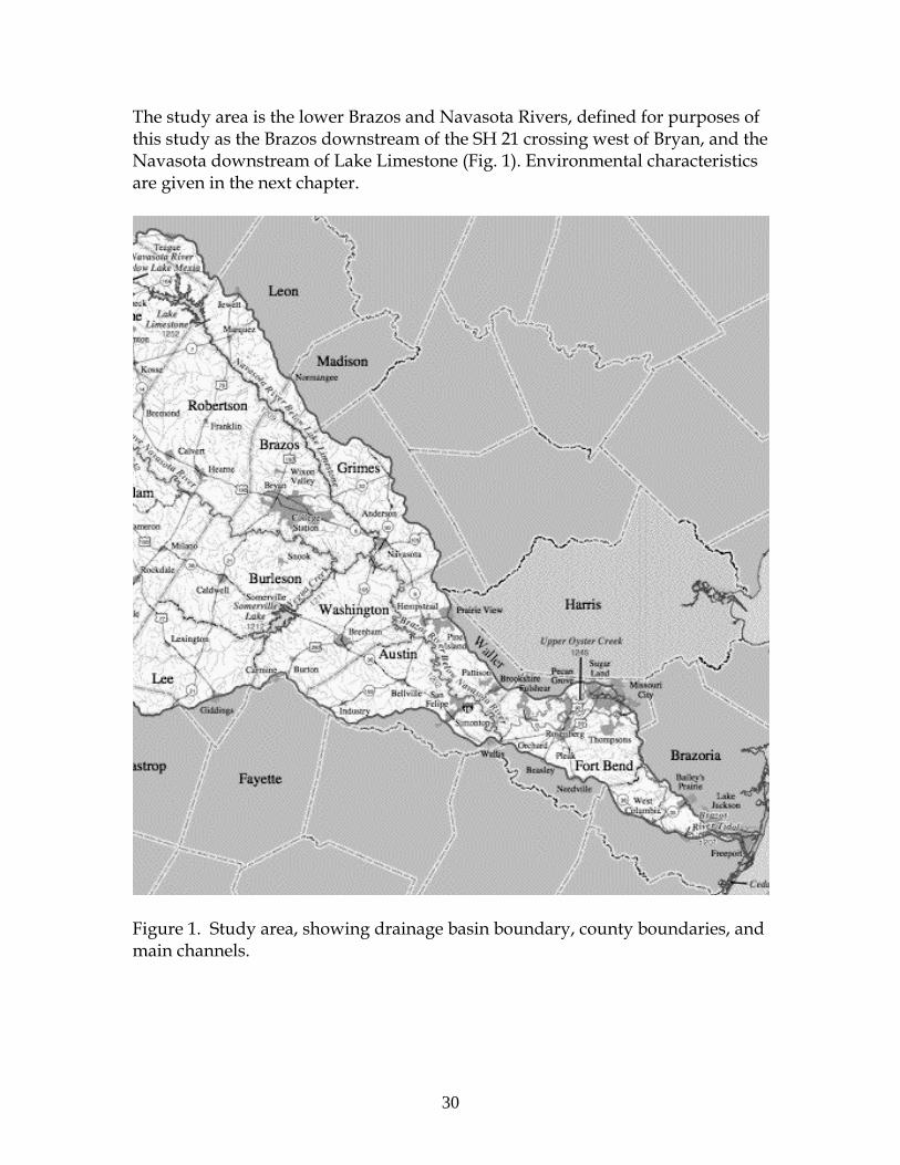
30
The study area is the lower Brazos and Navasota Rivers, defined for purposes of this study as the Brazos downstream of the SH 21 crossing west of Bryan, and the Navasota downstream of Lake Limestone (Fig. 1). Environmental characteristics are given in the next chapter.
Figure 1. Study area, showing drainage basin boundary, county boundaries, and main channels.

31
METHODS The general environmental framework of the Navasota and lower Brazos River basins (geology, soils, climate, land cover) is, like that of Texas as a whole, well-established. The Land Resources Map of Texas (Kier et al., 1977) is available, along with complete geologic mapping at a 1:250,000 scale (Geologic Atlas of Texas), and full soil map coverage. More specific background information from published research is reflected in the next chapter. Geologic frameworks and constraints were derived from 1:250,000 scale geologic maps from the Texas Bureau of Economic Geology (Geologic Atlas of Texas) from the Houston, Seguin, Austin, and Waco sheets. The Tectonic Map of the Texas Coastal Zone (Gulf Coast Association of Geological Societies) was used to identify potential tectonic influences. Discharge and river stage data from the U.S. Geological Survey were used to establish hydrologic regimes. The stations used are shown in Table 1. Mean daily streamflows were used to determine average discharges, and flows with recurrence probabilities of 1, 10 and 50 percent. Bankfull levels at each station and historic flood peaks were determined from the National Weather Service Advanced Hydrologic Prediction Service records for each station, along with the USGS record of annual peak flows. Table 1. US Geological Survey gaging Stations used in this study. Datum refers to the elevation of the gage above mean sea level; date is the beginning of regular recording at the site. The Bryan, Hempstead, Richmond, and Rosharon stations are on the Brazos River. The Easterly and Normangee stations are on the Navasosta. Name Location Number Drainage area
(km2) Datum (m)
Date
Bryan SH 21 W of Bryan 08108700 101,137 189.3 1993Hempstead US 290 W of Hempstead 08111500 113,649 33.5 1938Richmond US 90 08114000 116,827 8.7 1903Rosharon FM 1462 nr Brazos
Bend State Park 08116650 117,428 ~0 1967
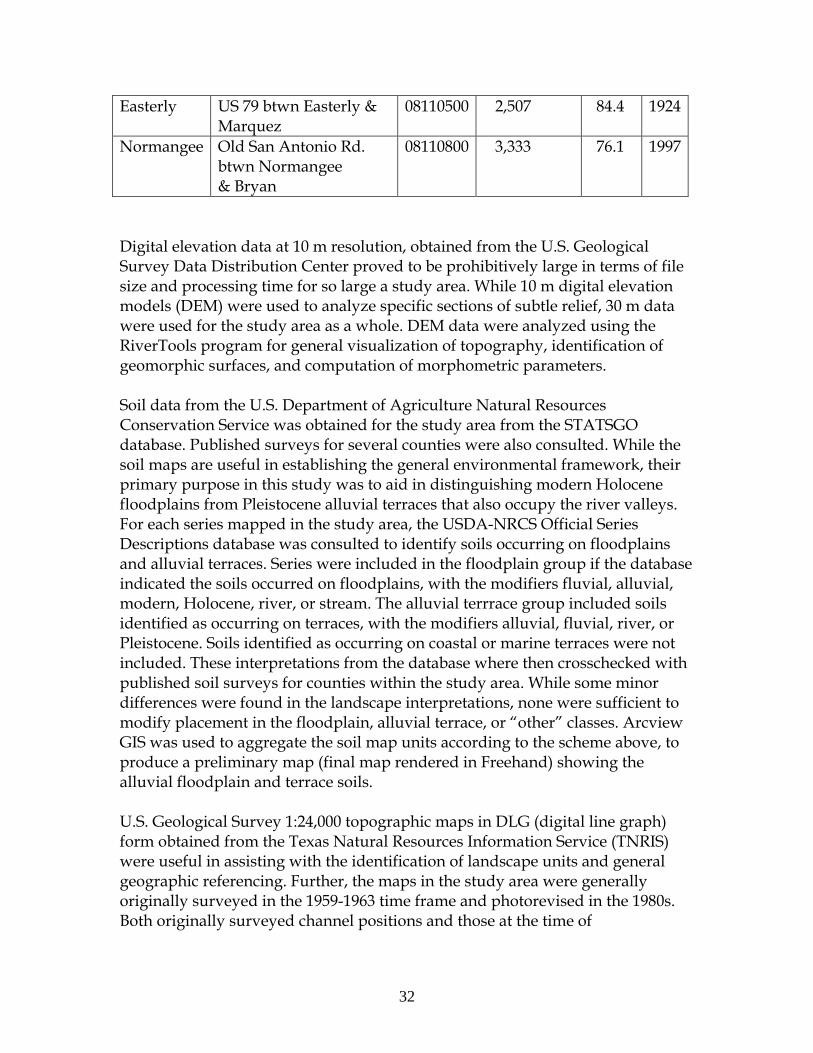
32
Easterly US 79 btwn Easterly & Marquez
08110500 2,507 84.4 1924
Normangee Old San Antonio Rd. btwn Normangee & Bryan
08110800 3,333 76.1 1997
Digital elevation data at 10 m resolution, obtained from the U.S. Geological Survey Data Distribution Center proved to be prohibitively large in terms of file size and processing time for so large a study area. While 10 m digital elevation models (DEM) were used to analyze specific sections of subtle relief, 30 m data were used for the study area as a whole. DEM data were analyzed using the RiverTools program for general visualization of topography, identification of geomorphic surfaces, and computation of morphometric parameters. Soil data from the U.S. Department of Agriculture Natural Resources Conservation Service was obtained for the study area from the STATSGO database. Published surveys for several counties were also consulted. While the soil maps are useful in establishing the general environmental framework, their primary purpose in this study was to aid in distinguishing modern Holocene floodplains from Pleistocene alluvial terraces that also occupy the river valleys. For each series mapped in the study area, the USDA-NRCS Official Series Descriptions database was consulted to identify soils occurring on floodplains and alluvial terraces. Series were included in the floodplain group if the database indicated the soils occurred on floodplains, with the modifiers fluvial, alluvial, modern, Holocene, river, or stream. The alluvial terrrace group included soils identified as occurring on terraces, with the modifiers alluvial, fluvial, river, or Pleistocene. Soils identified as occurring on coastal or marine terraces were not included. These interpretations from the database where then crosschecked with published soil surveys for counties within the study area. While some minor differences were found in the landscape interpretations, none were sufficient to modify placement in the floodplain, alluvial terrace, or “other” classes. Arcview GIS was used to aggregate the soil map units according to the scheme above, to produce a preliminary map (final map rendered in Freehand) showing the alluvial floodplain and terrace soils. U.S. Geological Survey 1:24,000 topographic maps in DLG (digital line graph) form obtained from the Texas Natural Resources Information Service (TNRIS) were useful in assisting with the identification of landscape units and general geographic referencing. Further, the maps in the study area were generally originally surveyed in the 1959-1963 time frame and photorevised in the 1980s. Both originally surveyed channel positions and those at the time of
33
photorevision are shown, allowing some assessment of change over a roughly two-decade period. Contemporary conditions, and further evidence of change, was discerned from 1-m resolution digital orthophotoquads (DOQQ) obtained from TNRIS. These are based on high-altitude aerial photography flown in 1994-1997. While these are the primary basis of assessments of current conditions and recent changes, more recent imagery (1-m National High Altitude Aerial Photography and 1 to 10 m resolution sattelite images) from the 2004-2006 period was used to cross-check the general interpretations and provide further information on difficult-to-interpret sites. No field work was included in the budget for this project, but is planned for future work. Results, in terms of the environmental framework of the lower Brazos and Navasota drainage basins, and a preliminary indentification of river styles, are presented in separate chapters.
Environmental Context of the Lower Brazos and Navasota Drainage Basins
INTRODUCTION The Brazos River is the largest in Texas, with a drainage area of about 118,000 km2, and a river length of more than 1,900 km from its headwaters in New Mexico to the Gulf of Mexico at Freeport (Figure 1). The 200 km Navasota River is the largest tributary of the lower Brazos, joining the latter at Washington, Texas. This chapter outlines the general environmental setting of the lower Brazos River (defined here as the area downstream of the state highway 21 crossing west of Bryan) and the Navasota river.

34
Figure 1. Brazos River basin. CLIMATE The climate is generally humid subtropical. Mean annual precipitation is about 990 mm in Brazos County, and 1,320 closer to the Gulf of Mexico in Brazoria County. Though precipitation occurs year-round, summer droughts and low-flow periods are common, due to the high evapotranspiration during this period. Average daily maximum temperatures range from 35o C in August to 140 in Janary, with an annual mean daily high of 25.5oC. Average daily minima are 23o in midsummer and 4o in January, with an annual mean of 14O C. These figures, for College Station, are representative of the area as a whole. Nordt et al. (1994) inferred late Pleistocene and Holocene climate change in the region from vegetation changes reflected in stable carbon isotopes in alluvial deposits and soils. Conditions in the late Pleistocene appear to have been cooler and moister than at any other time in the past 15 ka. Between 11 and 8 ka, a transition to warmer and drier Holocene conditions is inferred. In the mid-Holocene (~8 – 6 ka), expansion of warmer,

35
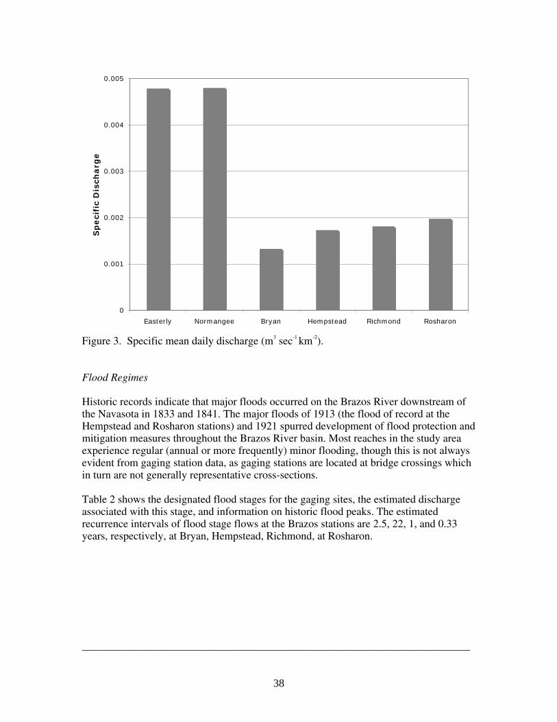
drier conditions occurred, followed by a shift to a cooler and wetter regime about 4 ka. (Nordt et al. 1994). HYDROLOGIC REGIMES Stream discharge and sediment transport at the Richmond station, the longest established in the area with records beginning in 1903, have been extensively analyzed elsewhere (Hudson and Mossa, 1997; Dunn and Raines, 2001; Osting et al., 2004). Reference flows for the six stations analyzed in this study are shown in table 1 and figure 2. _______________________________________________________________ Table 1. Reference flows for Brazos and Navasota River gaging stations, calculated from mean daily flows. Note that the Bryan and Normangee stations have short periods of record. Flood of record indicates the highest flow for which discharge has been measured or estimated by the U.S. Geological Survey. _______________________________________________________________ Flow ft3 sec-1 m3sec-1 _______________________________________________________________ Brazos at Bryan Mean daily 4727 134 1% 40500 1147 10% 12400 351 50% 1770 50 Flood of record (1999) 78600 2265 Brazos at Hempstead Mean daily 6916 196 1% 56600 1603 10% 17900 507 50% 2570 73
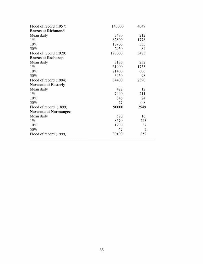
36
Flood of record (1957) 143000 4049 Brazos at Richmond Mean daily 7480 212 1% 62800 1778 10% 18900 535 50% 2950 84 Flood of record (1929) 123000 3483 Brazos at Rosharon Mean daily 8186 232 1% 61900 1753 10% 21400 606 50% 3450 98 Flood of record (1994) 84400 2390 Navasota at Easterly Mean daily 422 12 1% 7440 211 10% 846 24 50% 27 0.8 Flood of record (1899) 90000 2549 Navasota at Normangee Mean daily 570 16 1% 8570 243 10% 1290 37 50% 67 2 Flood of record (1999) 30100 852 _______________________________________________________________
37
0
200
400
600
800
1000
1200
1400
1600
1800
2000
Easterly Normangee Bryan Hempstead Richmond Rosharon
Gaging Stations
Mean Q
1%
10%
50%
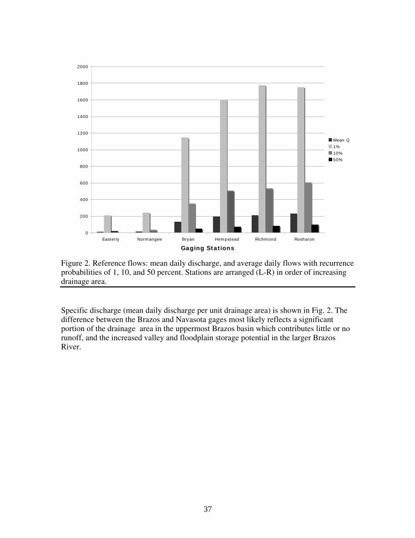
Figure 2. Reference flows: mean daily discharge, and average daily flows with recurrence probabilities of 1, 10, and 50 percent. Stations are arranged (L-R) in order of increasing drainage area. Specific discharge (mean daily discharge per unit drainage area) is shown in Fig. 2. The difference between the Brazos and Navasota gages most likely reflects a significant portion of the drainage area in the uppermost Brazos basin which contributes little or no runoff, and the increased valley and floodplain storage potential in the larger Brazos River.
38
0
0.001
0.002
0.003
0.004
0.005
Easterly Normangee Bryan Hempstead Richmond Rosharon
Sp
eci
fic
Dis
charg
e
Figure 3. Specific mean daily discharge (m3 sec-1 km-2). Flood Regimes Historic records indicate that major floods occurred on the Brazos River downstream of the Navasota in 1833 and 1841. The major floods of 1913 (the flood of record at the Hempstead and Rosharon stations) and 1921 spurred development of flood protection and mitigation measures throughout the Brazos River basin. Most reaches in the study area experience regular (annual or more frequently) minor flooding, though this is not always evident from gaging station data, as gaging stations are located at bridge crossings which in turn are not generally representative cross-sections. Table 2 shows the designated flood stages for the gaging sites, the estimated discharge associated with this stage, and information on historic flood peaks. The estimated recurrence intervals of flood stage flows at the Brazos stations are 2.5, 22, 1, and 0.33 years, respectively, at Bryan, Hempstead, Richmond, at Rosharon. _______________________________________________________________________
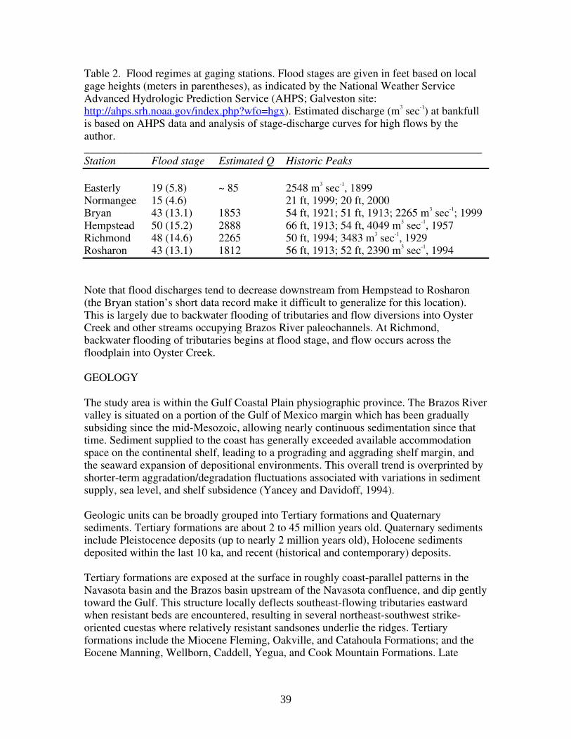
39
Table 2. Flood regimes at gaging stations. Flood stages are given in feet based on local gage heights (meters in parentheses), as indicated by the National Weather Service Advanced Hydrologic Prediction Service (AHPS; Galveston site: http://ahps.srh.noaa.gov/index.php?wfo=hgx). Estimated discharge (m3 sec-1) at bankfull is based on AHPS data and analysis of stage-discharge curves for high flows by the author. _______________________________________________________________________ Station Flood stage Estimated Q Historic Peaks Easterly 19 (5.8) ~ 85 2548 m3 sec-1, 1899 Normangee 15 (4.6) 21 ft, 1999; 20 ft, 2000 Bryan 43 (13.1) 1853 54 ft, 1921; 51 ft, 1913; 2265 m3 sec-1; 1999 Hempstead 50 (15.2) 2888 66 ft, 1913; 54 ft, 4049 m3 sec-1, 1957 Richmond 48 (14.6) 2265 50 ft, 1994; 3483 m3 sec-1, 1929 Rosharon 43 (13.1) 1812 56 ft, 1913; 52 ft, 2390 m3 sec-1, 1994 Note that flood discharges tend to decrease downstream from Hempstead to Rosharon (the Bryan station’s short data record make it difficult to generalize for this location). This is largely due to backwater flooding of tributaries and flow diversions into Oyster Creek and other streams occupying Brazos River paleochannels. At Richmond, backwater flooding of tributaries begins at flood stage, and flow occurs across the floodplain into Oyster Creek. GEOLOGY The study area is within the Gulf Coastal Plain physiographic province. The Brazos River valley is situated on a portion of the Gulf of Mexico margin which has been gradually subsiding since the mid-Mesozoic, allowing nearly continuous sedimentation since that time. Sediment supplied to the coast has generally exceeded available accommodation space on the continental shelf, leading to a prograding and aggrading shelf margin, and the seaward expansion of depositional environments. This overall trend is overprinted by shorter-term aggradation/degradation fluctuations associated with variations in sediment supply, sea level, and shelf subsidence (Yancey and Davidoff, 1994). Geologic units can be broadly grouped into Tertiary formations and Quaternary sediments. Tertiary formations are about 2 to 45 million years old. Quaternary sediments include Pleistocence deposits (up to nearly 2 million years old), Holocene sediments deposited within the last 10 ka, and recent (historical and contemporary) deposits. Tertiary formations are exposed at the surface in roughly coast-parallel patterns in the Navasota basin and the Brazos basin upstream of the Navasota confluence, and dip gently toward the Gulf. This structure locally deflects southeast-flowing tributaries eastward when resistant beds are encountered, resulting in several northeast-southwest strike-oriented cuestas where relatively resistant sandsones underlie the ridges. Tertiary formations include the Miocene Fleming, Oakville, and Catahoula Formations; and the Eocene Manning, Wellborn, Caddell, Yegua, and Cook Mountain Formations. Late

40
Pleistocene and Holocene alluvium occupy the Brazos and Navasota valleys, with older Quaternary alluvial terraces along the margins of both rivers and major tributaries. Downstream of the Navasota confluence, Quaternary formations comprise the uplands, the oldest of which are the Willis formation. The Lissie formation is of particular importance, as it creates a valley constriction near Hempstead, locally reducing valley width by about 50 percent. The incised valley of the Brazos is cut into the Willis and Lissie formations downstream as far as Richmond. From this point, the Pleistocene Beaumont formation bounds the valley. The Beaumont slopes gulfward at a gradient of about 0.0004, slightly greater than that of the average gradient of the Holocene alluvium and late Pleistocene alluvial terraces. The Brazos River is flanked by a modern floodplain and flights of several Pleistocene Terraces. The Beaumont terrace is correlative with the Prairie surface in Louisiana. Dates for the Prairie-Beaumont terrace in Louisiana and Texas compiled by Otvos (2005) range from 33 to 195 Ka. Otvos’ (2005) analysis places the deposition of the Beaumont terraces in Texas, which are 50 to 100 km wide from the coast, at 74 to 116 ka--broadly consistent with Blum et al. (1995) and Anderson et al. (1994). Between the Beaumont surface and often merging into the modern floodplain are a series of up to three alluvial surfaces. These are usually referred to as Deweyville, though they are not now generally believed to be part of a single terrace system (Blum et al. 1995; Morton et al. 1996). In most locations two or three separate “Deweyville” surfaces are recognized (Blum et al. 1995; Blum and Price, 1998; Morton et al. 1996; Rodriguez et al., 2005). The lowermost Deweyville surfaces are only slightly higher than the modern floodplain, and in some cases are buried by the latter, with natural levees of the modern floodplain higher than backswamps of the lower Deweyville (Alford and Holmes 1985; Blum et al. 1995; Rodriguez et al., 2005). The youngest of the Deweyville surfaces has been termed the Eagle Lake Alloformation by Blum and Price (1998). The three Deweyville surfaces are designated (youngest to oldest) the Fredonia, Sandjack, and Merryville allformations by the Louisiana Geological Survey (Heinrich et al., 2002). In the Colorado River, Texas, deposition of the youngest Deweyville alloformation from 20-14 ka was followed by bedrock valley incision 14-12 ka, with Holocene valley filling since (Blum and Price 1998). Waters and Nordt (1995), working in the Brazos River between Hearne and Navasota, found that the Brazos was a competent meandering stream from 18 to 8.5 Ka, leaving thick coarse lateral accretion deposits (such as those associated with Deweyville terraces) as it migrated across the floodplain. The transition to an underfit stream incised into those deposits and dominated by vertical accretion is dated to 8.5 Ka, with avulsions in narrow and unstable meander belts occurring on several occasions since (Waters and Nordt, 1995).
41
Unlike smaller rivers such as the Trinity, Neches, and Sabine, the Brazos has essentially filled its estuary and has an actively prograding delta. The location of the delta shifted in 1929 (see below) with the rerouting of the lowermost channel. While the delta is wave-dominated in general, during periods of high flow the Brazos delta is fluvially-dominated (Rodriguez et al., 2000). LANDSCAPE UNITS The topography, geology, and geologic history of the study area are reflected in six different landscape units within which fluvial channels and valleys occur. These are shown in figure 4 and described below: • Lower Coastal Plain. Low relief, low elevation (mainly < 3 m) minimally dissected surfaces composed entirely of Quaternary and largely of Holocene coastal, marine, deltaic, and alluvial sediments. • Quaternary Coastal Plain—Beaumont. Gently-rolling, low relief minimally dissected uplands primarily on the Pleistocene Beaumont formation in the lower and middle coastal plain. • Quaternary Coastal Plain—Lissie. Gently-rolling, moderately dissected uplands primarily on the Lissie (and to a lesser extent the Willis) formation, middle and upper coastal plain. • Miocene Uplands. Gently-rolling to moderately steep, strongly dissected uplands, primarily on the Fleming and Catahoula formations, and the Oakville sandstone. • Eocene Uplands. Gently-rolling to moderately steep, strongly dissected uplands, in generally northeast-southwest bands, with more resistant layers forming cuestas. Includes eight different Eocene formations. Pleistocene alluvial terraces and Holocene alluvial floodplains are also prominent within the study area, but as these occur within the river valleys they are not considered part of the landscape units providing the broader context for river styles.
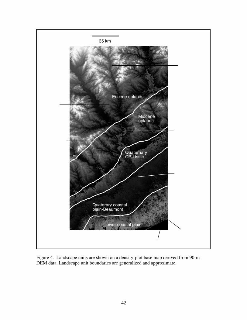
42
lower coastal plain
Quaterary coastalplain-Beaumont
QuaternaryCP-Lissie
Mioceneuplands
Eocene uplands
35 km
Figure 4. Landscape units are shown on a density-plot base map derived from 90-m DEM data. Landscape unit boundaries are generalized and approximate.
43
HUMAN IMPACTS While a full discussion of human impacts on the Brazos and Navasota watersheds is beyond the scope of this paper, several specific impacts on the geomorphology of the lower river are worthy of mention. Note, however, that human impacts are extensive—the Brazos watershed is home to an estimated 3.5 million people, and the lowermost Brazos basin is adjacent to the Houston metropolitan area, with a population of more than four million. Within the basin, however, land use is predominantly agricultural, though large petrochemical complexes exist near the mouth of the river. Dams and Reservoirs Nearly 1,200 reservoirs with storage capacities of > 50 acre-feet (61,700 m3) and/or dam heights of > 8 m are within the Brazos River basin (Dunn and Raines, 2001), along with innumerable smaller farm ponds and stock tanks. Nearly 90 percent of the controlled storage is in 13 reservoirs. The two most directly affecting the study area are Lake Limestone, at the upper end of the Navasota study area, and Lake Somerville, on Yegua Creek. Reductions in peak discharges, sediment transport, and lateral channel migration in the lower Brazos have been attributed to the effects of dams by various authors (Gillespie and Giardino, 1997; Hudson and Mossa, 1997; Dunn and Raines, 2001; Chin et al., 2002; Chin and Bowman, 2005). The first major dam, creating Possum Kingdom reservoir, was begun in 1938 and completed in 1941. Lake Whitney was impounded in 1951, Lake Somerville in 1967, and Lake Limestone in 1978. However, reservoir entrapment probably has little effect on sediment transport in the lower Brazos. The farthest downstream main-channel reservoir (Lake Whitney) is more than 560 km upstream of Richmond. Dunn and Raines (2001) found that reservoirs had no discernible impact on sand transport in the lower Brazos, while studies on the Trinity River showed minimal downstream geomorphic impacts of Lake Livingston beyond about 60 km downstream of the dam (Phillips et al., 2004; 2005). Sand Mining Several sand and gravel mining operations exist on the lower Brazos River between Hempstead and Rosharon. Dunn and Raines (2001) estimated that extractions may amount to 11 to 25 percent of the total sand transported by the Brazos, but they could not quantify the effects. Freeport Area In 1913 a major flood on both the Brazos and the Colorado Rivers occurred, reportedly causing the river mouths to join, temporarily creating a channel/lake more than 100 km wide. Devestation from this flood and others prompted various flood control efforts. In 1929, to alleviate flooding in the Freeport area and sedimentation in the Freeport harbor and ship channel, the Brazos River was rerouted to the southwest. The river now
44
takes a straight path from the Freeport/Lake Jackson area toward the Gulf, where the old, meandering channel (cut off from the river) is the Freeport Ship Channel. The new route has built a delta.
River Styles Classification
45
OVERVIEW This section presents the river styles classification for the study area. Included is a key specific to the study area. This presentation of the “river styles tree” (Brierly and Fryirs, 2005) was chosen over graphic forms because it is more readily updated pending fieldwork and revision. Note that a river styles tree or key is designed to differentiate among the styles found in a given study area rather than to provide an overarching framework for classification in other areas. In other words, identification of river styles comes first—the key is a communication and interpretation tool; not the template for classification. Also included are descriptions of each river style identified (the “proforma” of Brierly and Fryirs, 2005). Note that information on bed materials and geomorphic units is tentative and incomplete. These features cannot be fully or confidently identified without field investigation. Finally, the specific geographic designations of river reaches are given. Several river styles are described as “avulsed.” An avulsion is a relatively sudden course change in an alluvial river, whereby the existing channel is abandoned. Several portions of the study area have been characterized by avulsions, with the older paleochannels of the Brazos River occupied by tributaries such as Old River, the lowermost Navasota River, and Bessie, Jones and Oyster Creeks.

46
RIVER STYLES KEY 1. Valley confined, partly confined, or unconfined? A. Channel abuts valley wall along > 90 percent of its length Confined: go to 2 B. Channel abuts valley wall along 10 to 90 percent of its length Partly confined: go to 3 C. Channel abuts valley wall along < 10 percent of its length Unconfined: go to 4 2. Confined valleys A. Quaternary coastal plain setting (landscape units) Coastal Plain Confined B. Tertiary (Miocene, Eocene) landscape units i. Channel bed material dominantly bedrock Bedrock ii. Channel bed material dominantly unconsolidated •Avulsed Upland Confined Avulsed •Not avulsed Upland Confined 3. Partly confined valley A. Avulsed i. Quaternary coastal plain setting (landscape unit) Partly Confined Avulsed ii. Tertiary (Eocene) landscape unit Partly Confined High Sinuousity Avulsed B. Not avulsed i. Bedrock controlled valley Bedrock Controlled Valley ii. Multiple channels or anabranches at high flow Multiple High Flow Channel iii. Single dominant channel at high flows; valley not bedrock controlled Partly Confined High Sinuousity (continued on following page)
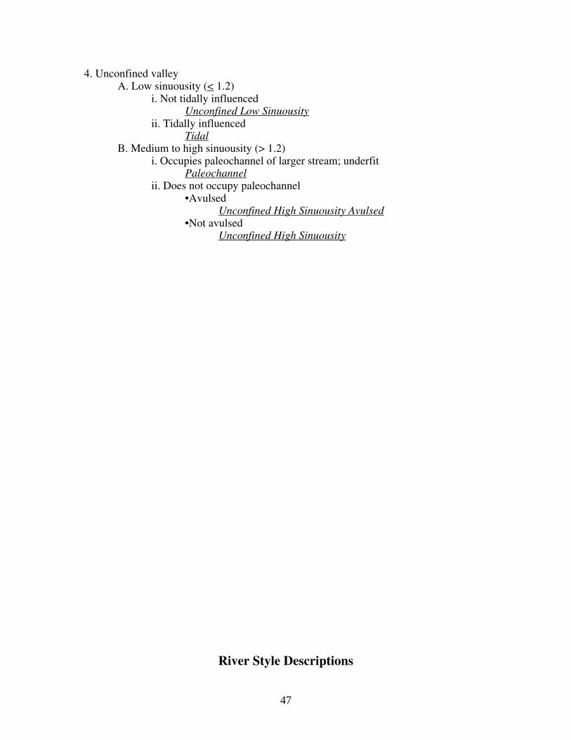
47
4. Unconfined valley A. Low sinuousity (< 1.2) i. Not tidally influenced Unconfined Low Sinuousity ii. Tidally influenced Tidal B. Medium to high sinuousity (> 1.2) i. Occupies paleochannel of larger stream; underfit Paleochannel ii. Does not occupy paleochannel •Avulsed Unconfined High Sinuousity Avulsed •Not avulsed Unconfined High Sinuousity
River Style Descriptions

48
TIDAL Defining attributes: This river style is found only near the mouth of the Brazos, in the Brazoria/Lake Jackson/Freeport area. The river flows across a low-elevation, low-relief fluviodeltaic plain. Downstream of Freeport, the channel was relocated in 1929. The new channel is straight, leveed, and intersects the Gulf Intracoastal Waterway. An active delta is building at the river mouth, which is normally wave-dominated, but fluvially-dominated at high flows. Landscape unit(s): Lower Coastal Plain Representative reach: Brazos River from Brazoria to Gulf of Mexico Valley setting: Laterally unconfined. Channel planform: Continous floodplains along both margins. Single-thread channel, low sinousity; articially straightened in lower reaches. Distributary network. Bed material: Sand and mud. Geomorphic units: All alluvial. •Meander cutoffs/oxbows. •Sloughs (former channel positions) •Prograding delta. •Meander apex cutbanks. •Vegetated, possibly fine-grained point bars. UCLS (UNCONFINED LOW SINUOUSITY)
49
Defining attributes: Characterized by an incised, unconfined channel with sinuousity < 1.2, including straight reaches, minor bends, and isolated meanders. Tributaries and distributaries occupy Brazos River paleochannels, with oxbows and sloughs present. Tributaries not occupying former river channels are strongly incised. Landscape unit(s): Quaternary Coastal Plain Uplands--Beaumont Representative reach: Brazos River from just north of Harris Reservoir to Brazoria Valley setting: Laterally unconfined. Channel planform: Continous floodplains along both margins. Single-thread channel, low sinuosity, Bed material: Sand. Geomorphic units: All alluvial. •Meander cutoffs/oxbows. •Sloughs (former channel positions) •Brazos River paleochannels occupied by tributaries (Oyster Creek) •Cutbanks. •Alluvial terraces UCHS avulsed (UNCONFINED HIGH SINUOUSITY AVULSED)
50
Defining attributes: Characterized by an incised unconfined channel with sinuousity > 1.2. Active lateral migration. Tributaries and distributaries occupy Brazos River paleochannels, with numerous oxbows and sloughs present. Tributaries not occupying former river channels are strongly incised. Landscape unit(s): Coastal Plain Uplands--Beaumont Representative reach: Brazos River from Richmond to Harris Reservoir Valley setting: Laterally unconfined Channel planform: Continuous floodplains and occasional terrace remnants along both margins. Meandering single-thread channel. Bed material: Sand. Geomorphic units: All alluvial. •Meander cutoffs/oxbows. •Sloughs (former channel positions) •Brazos River paleochannels occupied by tributaries •Cutbanks. •Point bars •Paleomeander scars •Alluvial terraces CP CONFINED (COASTAL PLAIN CONFINED)

51
Defining attributes: Incised river channel against right (west) valley side slope with extensive floodplain on left (east) valley side occupied by highly sinuous tributaries in Brazos River paleochannel. Strongly incised tributaries on left margin. Landscape unit(s): Quaternary Coastal Plain Uplands—Lissie; Quaternary Coastal Plain Uplands--Beaumont Representative reach: Brazos River from Allens Creek (near FM 1093 crossing) to Richmond Valley setting: Laterally confined. Channel planform: Continous floodplain along left margin; uplands and alluvial terraces along right. Meandering to straight single-thread channel. Bed material: Sand. Geomorphic units: All alluvial. •Meander cutoffs/oxbows. •Brazos River paleochannels occupied by tributaries •Tie channels connecting tributary paleochannels and Brazos •Cutbanks. •Point bars •Paleomeander scars •Alluvial terraces PC AVULSED (PARTLY CONFINED AVULSED)
52
Defining attributes: Incised river channel mainly unconfined but sometimes pinned again against right (west) valley side slope. Highly active, laterally migrating. Extensive floodplain mainly on left (east) valley side occupied by highly sinuous tributaries in Brazos River paleochannel. Upper end of avulsion with Jones, Bessie, Oyster, and other creeks occupying Brazos paleochannels. Landscape unit(s): Quaternary Coastal Plain Uplands—Lissie Representative reach: Brazos River from Garretts Lake (near S.F. Austin State Park) to Allens Creek (near FM 1093 crossing) Valley setting: Partly laterally confined. Channel planform: Continous floodplain along left margin; floodplain, uplands and alluvial terraces along right. Meandering single-thread channel. Bed material: Sand. Geomorphic units: All alluvial. •Meander cutoffs/oxbows. •Sloughs (former channel position) •Brazos River paleochannels occupied by tributaries •Tie channels connecting tributary paleochannels and Brazos •Cutbanks. •Point bars •Paleomeander scars •Alluvial terraces PCHS (PARTIALLY CONFINED HIGH SINUOUSITY)
53
Defining attributes: Incised meandering (sinuousity > 1.2) river channel with highly active lateral migration and numerous oxbows and cutoffs. Tributaries strongly incised. Landscape unit(s): Miocene Uplands Representative reach: Brazos River from Navasota River (near Washington) to Little Cedar Creek (near Hempstead); Navasota River from Old RR grade near Navasota to Holland Creek valley. Valley setting: Partly laterally confined. Channel planform: Continous floodplain with channel occasionally pinned to either margin. Meandering single-thread channel. Bed material: Sand. Geomorphic units: All alluvial. •Meander cutoffs/oxbows. •Cutbanks. •Point bars •Alluvial terraces UCHS (UNCONFINED HIGH SINUOUSITY)
54
Defining attributes: Characterized by an incised unconfined channel with sinuousity > 1.2. Active lateral migration. Numerous oxbows and sloughs present. Tributaries are strongly incised. Landscape unit(s): Quaternary Coastal Plain Uplands—Lissie; Eocene Uplands Representative reach: Brazos River from Clear Creek (Raccoon Bend) to Garretts Lake (near S.F. Austin State Park); Brazos from Boggy Creek to Yegua Creek (Brazos Co.). Valley setting: Laterally unconfined. Channel planform: Continous floodplains and occasional terrace remnants along both margins. Meandering single-thread channel. Bed material: Sand. Geomorphic units: All alluvial. •Meander cutoffs/oxbows. •Sloughs (former channel positions) •Cutbanks. •Point bars •Paleomeander scars •Alluvial terraces BCV (BEDROCK-CONFINED VALLEY)
55
Defining attributes: Characterized by an incised partly confined channel with sinuousity > 1.2 and active lateral migration, but confined within a relatively narrow bedrock-controlled valley. Landscape unit(s): Miocene Uplands; Quaternary Coastal Plain Uplands--Lissie Representative reach: Brazos River in the vicinity of Hempstead, from Little Cedar Creek to Clear Creek (Raccoon Bend). Valley setting: Laterally unconfined within relatively narrow bedrock-controlled valley. Channel planform: Continous floodplains and occasional terrace remnants along both margins. Meandering single-thread channel. Bed material: Sand. Geomorphic units: All alluvial. •Meander cutoffs/oxbows. •Sloughs (former channel positions) •Cutbanks. •Point bars •Alluvial terraces UpC avulsed (UPLAND, CONFINED, AVULSED)

56
Defining attributes: Incised, confined channel pinned against valley side; floodplain characterized by sinuous tributaries occupying Brazos River paleochannel. Active lateral migration and strongly incised tributaries. Landscape unit(s): Miocene Uplands Representative reach: Brazos River from Yegua Creek to Navasota River Valley setting: Confined Channel planform: Continous floodplains and occasional terrace remnants along left margin. Meandering single-thread channel. Bed material: Sand. Geomorphic units: All alluvial. •Meander cutoffs/oxbows. •Sloughs (former channel positions) •Brazos River paleochannel occupied by tributaries. •Cutbanks. •Point bars •Alluvial terrace •Bedrock riffle (if Hidalgo Falls considered a geomorphic unit rather than a separate style). BEDROCK Defining attributes: Incised channel with exposed bedrock in bed; falls and riffles.

57
Landscape unit(s): Miocene Uplands Representative reach: Hidalgo Falls Valley setting: Confined. Channel planform: Straight; confined to one valley side; floodplain on other margin. Bed material: Bedrock. Geomorphic units: •Bedrock falls/riffle PCHS avulsed (PARTIALLY CONFINED HIGH SINUOUSITY, AVULSED) Defining attributes: Incised meandering (sinuousity > 1.2) river channel with highly active lateral migration and numerous oxbows and cutoffs. Tributaries strongly incised.
58
Channel mainly pinned to left (east) valley side. Parallel tributary occupies Brazos paleochannel on extensive floodplain. Landscape unit(s): Eocene Uplands Representative reach: Brazos River from SH 21 near Bryan to Boggy Creek (Brazos County). Valley setting: Partly laterally confined. Channel planform: Continous floodplain on right (west) margin. Uplands, terrace remnants, floodplain on left margin. Meandering single-thread channel. Bed material: Sand, bedrock Geomorphic units: •Meander cutoffs/oxbows. •Cutbanks. •Point bars •Alluvial terraces •Paleochannel occupied by tributaries. •Bedrock channel outcrops. PALEOCHANNEL Defining attributes: Incised meandering (sinuousity > 1.2) channel confined within abandoned paleochannel of larger stream.
59
Landscape unit(s): Eocene Uplands Representative reach: Navasota River from Big Creek to Brazos River. Valley setting: Unconfined. Channel planform: Continuous floodplain on both margins. Meandering single-thread channel. Bed material: Sand Geomorphic units: •Cutbanks. •Paleochannel trough •Alluvial terraces UPLAND CONFINED Defining attributes: Incised meandering channel confined to valley side of alluvial valley. Landscape unit(s): Miocene Uplands
60
Representative reach: Navasota River from Holland Creek valley to Big Creek. Valley setting: Confined. Channel planform: Continous floodplain and terraces on right margin. Meandering single-thread channel. Bed material: Sand Geomorphic units: •Cutbanks. •Swamp depression in meander cutoff •Alluvial terraces MHFC (MULTIPLE HIGH FLOW CHANNEL) Defining attributes: Strongly meandering (sinuousity > 1.5) channel with high-flow subchannels, and tie channels to sloughs and backswamp depressions. Landscape unit(s): Eocene Uplands

61
Representative reach: Navasota River from Lake Limestone to old RR grade near Navasota. Valley setting: Partially confined. Channel planform: Continous floodplain. Meandering single-thread channel dominant channel; multiple channels and anabranches at high flows. Bed material: Sand Geomorphic units: •Cutbanks. •Cutoffs, oxbows •Sloughs, high-flow subchannels, anabranches •Tie channels •Paleomeanders REACHES The table below indicates the classified reaches, in a downstream – upstream direction. The general location of the up- and downstream ends of the reach are given, along with latitude-longitude coordinates. These are mapped in figures 1 and 2. Table 1. River Styles classification of stream reaches.
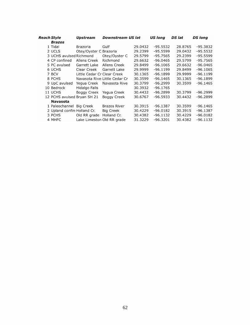
62
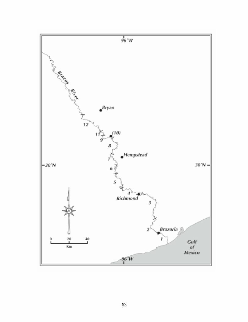
63

64
Figure 1. Reaches of the lower Brazos River. River style for each numbered reach is shown in Table 1.

65
Figure 2. Reaches of the Navasota River below Lake Limestone. River style for each numbered reach is shown in Table 1.
Trajectories of Change
INTRODUCTION Like rivers themselves, river styles are not static. An important aspect of RS assessment is the determination of trajectories of change. This includes, to the extent possible, Quaternary changes and geologic evolution trends that influence the current state of the fluvial system as well as contemporary and historic changes. The assessment of trajectories of change also involves the identification of controls or feedback mechanisms that may slow, limit or modify future changes. A full assessment of past and ongoing changes requires fieldwork. Thus, this section should be considered preliminary. DISCHARGE The record of daily flows at the Bryan, Hempstead, Richmond, and Rosharon gaging stations on the Brazos River, and the Easterly and Normangee stations on the Navasota, do not show any significant upward or downward trends over their varying periods of record. Gillespie and Giardino (1997) compared pre- and post-1939 discharges (pre- and post-dam) at the Waco, Hempstead, and Richmond stations, finding significantly higher flows, on average, before 1939. Oosting et al. (2004) updated this analysis at the Richmond station, finding that high flows are slightly less and low flows slightly more frequent post 1940, but that the differences were minor. An analysis of the period 1923-1974 by Mathewson and Minter (1976) found that upstream reservoir construction on the Brazos River slightly reduced the frequency of large discharges at Richmond, but did not affect the mean annual flow. Thus, while there is some evidence of discharge changes before and after roughly 1940, there are no detectable recent or ongoing trends of change in the discharge regime. CROSS-SECTION MORPHOLOGY

66
Changes in cross-section morphology concern changes in channel size, shape, and hydraulic characteristics, principally width, depth, slope, and roughness. Depth Stage-discharge relationships for the Hempstead, Richmond, and Rosharon stations were analyzed by Dunn and Raines (2001) to determine changes in water surface altitude at specific discharges. For a discharge of 5,000 ft3 sec-1 (142 m3 sec1) the long term decline in water surface elevation has been about 0.0085 m yr-
1 at the Hempstead station, 0.017 at Richmond, and 0.020 m yr-1 at Rosharon, with statistically significant slopes for the trend lines (Dunn and Raines, 2001). This trend indicates net bed degradation or channel incision on the order of a meter (2 to 4 feet) over the period of record. On a longer time scale, Waters and Nordt (1995) found that at about 8.5 ka the Brazos transformed from a meandering stream dominated by lateral accretion deposits to an underfit stream incised within the earlier deposits. Tributaries to the Brazos River—even very small ones—are typically strongly incised. This is consistent with recent or ongoing incision in the main channel, as the tributaries would be expected to downcut in response to the lower base level associated with trunk stream incision. This morphological evidence, combined with Dunn and Raines’ (2001) analysis, suggests ongoing incision. This is a critical issue for future work. Field examinations of channel bank morphology, bed conditions at low water, and riparian vegetation may indicate the extent to which incision is active. Further, bed lowering in the vicinity of bridge crossings and other features may be discernible. Vertical scour in the lower Trinity River—in that case due to Livingston Dam—is evident from various types of morphological and other evidence (Phillips et al., 2005). The lower Trinity and its tributaries are cut to or close to more resistant bedrock or pre-Quaternary deposits, which may limit future incision. The extent to which this is the case in the lower Brazos should also be determined. There is no published geomorphic or hydrologic research on the Navasota River. The images and maps in this study do not show any obvious indications of incision, except in the lowermost reaches (RS = paleochannel). The Navasota river is less incised than the Brazos, and the tributaries do not appear incised. Width Bank erosion and cutbanks are ubiquitous in both rivers of the study area. However, they are typically associated with point bars or infilling banks on the opposite bank. Further, in any given reach channel widths are comparable, in the
67
~1960, 1980s, 1990s, and 2004-2006 channels shown on maps and aerial photographs. Thus there is no evidence of general channel widening, though widening may occur locally. Roughness The general roughness characteristics of the Brazos and Navasota (as opposed to event-specific hydraulic roughness or friction factors) are associated primarily with channel planform, discussed below, bedforms, and large woody debris. There are no obvious changes in the general characteristics of size and frequency of larger bedforms (point, channel margin, and tributary mouth bars) visible on imagery, though these forms are typically active and mobile, and dramatic changes have occurred in some individual reaches or cross-sections. Coarse woody debris (CWD), often associated with bank erosion, is a key element of both hydraulic roughness and habitat in the lower Brazos and the Navasota (Oosting et al., 2004). Again, the local specifics of CWD are quite dynamic, but there is no evidence of a change in the CWD regime of either river. Slope While it is energy grade slope (often approximated by water surface slope) that is critical from a hydraulic perspective, general changes in reach slope are associated with changes in channel bed slope. The data used in this study cannot be used to determine recent or historic slope changes. However, there is evidence of a Holocene increase in slope. As this is associated with Holocene avulsion, it is discussed in the following section. PLANFORM Planform change refers to planimetric changes in the number, sinuousity, and position of channels. With the exception of the lowermost Brazos River (river style Tidal), lateral channel change and migration is active throughout the study area. This includes general channel migration and local channel shifts, the cutoff and abandonment of meander bends, and the formation of new and exaggeration of existing meander bends. Active cutbanks, point bars, and other forms of infill are ubiquitous. While channel migration rates as determined from aerial photographs apparently slowed in the post-dam period (Gillespie and Giardino, 1997), the majority of the lower Brazos and Navasota Rivers are actively laterally migrating systems. Confined river styles and the confined subreaches of partly confined styles are not excepted from the generalization above. In these cases, however, the
68
probability of future migration is toward the lower elevation, generally more erodible floodplain and away from the valley side. Over longer timescales, the Brazos River from Bryan to the vicinity of Fulshear does not appear to have experienced any general, significant changes in sinuousity, based on comparing the modern channel with the paleochannels in the valley currently occupied by Old River, the lowermost Navasota River, and other tributaries. In the lower 253 km of the Brazos River, an avulsion occurred at some point in the Holocene. The former Brazos River channel, now occupied by Oyster, Jones, and Bessie’s Creeks, is significantly more sinuous than the modern channel. Whereas the modern river length from the avulsion point to the Gulf of Mexico is 253 km, the length along the paleochannel is about 325 km. This channel shift represents an increase in average slope from the avulsion point to the Gulf from 0.0001168 to 0.00015 (28 percent). This could account for the incision noted above. The timing of the avulsion is unknown. It had occurred before 1824, as historic surveys of the area from that date show both the Brazos River and Oyster Creek in their approximate modern locations. The model of Quaternary alluvial plain construction in the Texas Coastal Plain by Blum and Price (1998) includes an avulsion to a new meanderbelt position during late sea level highstand. Sea level history of the Texas and Gulf Coastal Plains is controversial (c.f. Blum et al., 2002; Otvos, 2005), but Blum et al. (2001) present evidence for a middle Holocene highstand in the central Texas coastal area. Studies by the Gulf of Mexico Research Group at Rice University indicate that the Brazos and Colorado Rivers have each avulsed at least three times during the transgressive phase of the last ~15 ka, with Oyster Creek being one of the channels formed in this period, based on seismic records and cores collected offshore of Oyster Creek (Anderson et al., 1992; Rodriguez et al., 2000; 2004). In the Brazos River upstream of the Navasota, Waters and Nordt (1995) found evidence of four Holocene avulsion events, at about 8.1, 2.5, 0.5, and 0.3 ka. The upstream (of the Navasota) avulsions do not appear to have resulted in significant changes in sinuousity, however. The nature and timing of avulsions in the lower Brazos, particularly the Oyster Creek avulsion, should be a priority in future work. This is also relevant to the Navasota River, which downstream of the town of Navasota occupies a former Brazos River channel. Beyond the inherent geomorphological and sedimentological importance of avulsions, in the Brazos/Navasota system the presence of (geologically) recent avulsions helps define some of the major river
69
styles. Since the abandoned channels are occupied by tributaries and seem to be hydraulically connected to the modern river, the avulsions are also critical in creating floodplain connectivity. Finally, they influence--at least administratively --the watershed boundaries. The apparently abnormally narrow lower drainage basin of the Brazos (and the Colorado) are a direct result of avulsions, with streams such as Oyster Creek occupying the former river channel. The Oyster Creek basin is actually part of the Brazos distributary system, but in the hydrdologic accounting units is treated as part of a separate basin. Preliminary studies doe not suggest that the avulsions are a result of human activity, but this needs further investigations. The Navasota River, while not as actively migrating as the Brazos, is nonetheless an active laterally-migrating channel, as indicated by active cutbanks, point bars, and marginal bars. Meander cutoff and abandonment and the formation of new and exaggeration of existing meander bends is common. Two features of the Navasota which require further investigation are: •The multiple high flow channels which appear to give the river an anabranching planform at flood flows, and a high degree of channel-floodplain connectivity even at sub-bankfull flows. •Several instances where recent channel changes have abandoned apparently straighter routes in favor of more meandering routes. These may represent local avulsions involving the reoccupation of former channels. BASE LEVEL The overwhelming base level controls for the lower Brazos River are those associated with Quaternary sea level change. From a sedimentary geology perspective, the study area has been in a transgressive phase since about 15 ka. There have, however, been Holocene sea level fluctuations, though the number, magnitude, rate, and timing of these is subject to considerable debate. The Gulf of Mexico reached roughly its current position about 4 ka, with slow eustatic rates on the order of 2 to 3 mm yr-1since then. The Brazos River is the base level for the Navasota. Recent incision in the Brazos has triggered some incision in the lower Navasota. SEDIMENT TRANSPORT

70
Three periods with distinctly different sediment transport regimes in the lower Brazos River were identified by Seelig and Sorenson (1973). From 1922-40, suspended sediment concentrations averaged about 5,000 parts per million (ppm), and from 1941-50, concentrations generally declined to about 2,000 ppm. In the 1951-65 period, concentrations declined slightly, but remained in the 1,000 to 3,000 ppm range. Seelig and Sorenson (1973) ascribed the decline to a combination of sediment trapping in upstream dams, improved soil conservation, and land use change. Mathewson and Minter (1976) found that suspended sediment concentrations and total sediment loads at Richmond decreased over the 1924-70 period. They attributed the reduction to a combination of sediment storage in bars between Waco and the lower reaches of the river, and reduced frequency of high flows. The sediment transport record for Richmond was divided into pre- and post-dam periods (before and after 1939) by Gillespie and Giardino (1997). Their statistical analysis showed that pre-dam discharge and sediment concentrations were significantly greater than after 1939. Dunn and Raines (2001) found that the percentage of sand at a given discharge declined at the Richmond station over the 1982-95 period compared to 1969-81, possibly related to a change in typical velocities. However, they also found no statistically significant change in the median annual load. The Brazos River at Richmond transports most sediment during moderate discharge events, with 90 percent of the load transported in 17 percent of cumulative time (Hudson and Mossa, 1997). Thus, the changes in discharge, which have primarily influenced higher and lower flows, likely have had limited influence on sediment transport capacity. Dunn and Raines (2001) approached the sediment transport problem from the perspective of shear stress necessary to mobilize the coarsest bed material, concluding that the lower Brazos has sufficient capacity to entrain these clasts at least 11 percent of the time. At least 82 percent of the time, the Brazos River can mobilize its typical bed material (Dunn and Raines ,2001). A significant decrease in cropland area (from 32 to about 8 percent in the lower Brazos basin from 1924-92) has substantially reduced erosion potential and thus, potentially, sediment delivery (Dunn and Raines, 2001). However, the prevalence of bars in both the Navasota and Brazos Rivers, the apparently active alluvial sedimentation, and the ready availability of transportable channel and floodplain alluvium, suggests that both rivers are transport-limited rather than supply-limited. To the extent any changes in sediment transport occur, they are likely to be attributable to changes in transport capacity rather than supplies from upland
71
erosion. This may be addressed during sediment budget studies, which should be coupled with assessment of evidence of changes in sediment transport throughout the study reaches, as the records from the Richmond station are the basis for almost all previous work. CAUSES OF CHANGE The primary driving forces of Quaternary, historic, and ongoing change in the Navasota and lower Brazos Rivers are climate, sea level, human agency, and the intrinsic interactions and feedbacks within the fluvial system. The imprint of climate on the study area and other east Texas Rivers is clear—for example, all major rivers in the region show evidence of significantly higher discharges at the time the Deweyville terraces were deposited during wetter climate and lower sea level periods in the late Pleistocene (see p. 36). However, responses to climate change may be complex, and large changes in climate may not be necessary to elicit major responses in the fluvial system. Waters and Nordt’s (1995) study found that Brazos River changes could not generally be attributed to any specific cause, but rather to the complex interplay of climate, sediment yield, and intrinsic floodplain variables. In the Trinity River the upstream limit of effects of Holocene sea level rise define a critical transition zone for sediment transport and storage, channel and floodplain morphology, and channel change (Phillips et al., 2004; 2005). The possibility of similar effects in the Brazos should be examined, though due to fundamental differences in slope gradients, river-estuary interactions, and Holocene histories, the Brazos may not behave as the Trinity (Anderson et al., 1992; Blum and Price, 1998; Phillips and Slattery, 2006). Human effects include direct impacts on the rivers, such as impoundment, water withdrawal, sand mining, and channelization. Anthropic impacts also include land use and land cover changes which influence runoff and erosion within the drainage basin. The most abrupt changes in the study rivers are associated with avulsions and meander cutoffs. Thus the preconditions which make sites susceptible to these changes, the triggering events, and the local fluvial reactions to these events should be a priority for future work. SUMMARY

72
Table 1 below summarizes the recent and ongoing geomorphic changes noted, the river styles affected, and priorities for further research. Table 1. Geomorphic changes and research priorities in the lower Brazos and Navasota Rivers. Geomorphic Change
River Styles Affected Research Priorities
Incision and bed degradation
UCLS, UCHS, UCHS avulsed, CP confined, PC avulsed, BCV, PCHS, UpC avulsed, PCHS avulsed, paleochannel
Potential bedrock limits, role of slope changes due to avulsion
Slope increase Brazos downstream of Garrett Lake (tidal, UCLS, UCHS avulsed, CP confined, PC avulsed
Potential slope changes due to planform change elsewhere in study area
Lateral migration All Effects of valley-side confinement on rate, directly, and style of migration
Meander cutoff & abandonment
All except tidal Preconditioning and triggering mechanisms
Meander formation & growth
All Preconditioning and triggering mechanisms
Avulsion Existing effects: paleochannel and all “avulsed” styles. Potential effects: all except bedrock and BCV
Preconditioning and triggering mechanisms; timing of Holocene avulsions
Decreased sediment transport?
All? Field indicators of sediment flux regimes; changes in transport capacity
Backwater effects of sea level rise
Tidal, UCLS; UCHS avulsed? Identification of upstream limit of backwater effects & potential sediment transport bottlenecks
Planform changes in the Navasota River
MHFC Formation of multiple high flow channels & distributary channels
References Cited (part 2)

73
Alford, J.J., Holmes, J.C., 1985. Meander scars as evidence of major climate change in southwest Louisiana. Annals of the Association of American Geographers 75, 395-403. Anderson, J.B., Thomas, M.A., Siringan, F.P., Smyth, W.C. , 1992. Quaternary evolution of the east Texas coast and continental shelf. In C.H. Fletcher III and J.F. Wehmiller, eds., Quaternary Coastlines of the United States: Marine and Lacustrine Systems, SEPM (Society for Sedimentary Geology), 253-263. Barnes, V., 1982. Geologic Atlas of Texas: Houston Sheet (1:250,000 map). Austin: Texas Bureau of Economic Geology. Blum, M. D., Carter, A. E., Zayac, T., and Goble, R. J., 2002. Middle Holocene Sea-Level and Evolution of the Gulf of Mexico Coast (USA). Journal of Coastal Research. Special Issue 36, 65-80. Blum, M.D., Misner, T.J., Collins, E.S., Scott, D.B., Morton, R.A., Aslan, A., 2001. Middle Holocene sea level rise and highstand at +2m, central Texas coast. Journal of Sedimentary Research 71, 581-588. Blum, M.D., Morton, R.A., Durbin, J.M., 1995. “Deweyville” terraces and deposits of the Texas Gulf coastal plain. Gulf Coast Association of Geological Societies Transactions 45, 53-60. Blum, M.D., Price, D.M., 1998. Quaternary alluvial plain construction in response to glacio-eustatic and climatic controls, Texas Gulf Coastal Plain. In Shanley, K., McCabe, P., eds., Relative Role of Eustasy, Climate, and Tectonism in Continental Rocks. Tulsa, OK, Society for Sedimentary Geology, SEPM spec. publ. 59, 31-48. Blum, M.D., Törnqvist, T.E., 2000. Fluvial responses to climate and sea-lvel change: a review and look forward. Sedimentology 47, 2-48. Chin, A., Bowman, J.A., 2005. Changes in flow regime following dam construction, Yegua Creek, south-central Texas. In Norwine, J., Giardino, J.R., Krishnamurthy, S., eds., Water for Texas. College Station: Texas A&M University Press, p. 166-177. Chin, A., Harris, D.L., Trice, T.H., Given, J.L., 2002. Adjustment of stream channel capacity following dam closure, Yegua Creek, Texas. Journal of the American Water Resources Association 38, 1521-1531.
74
Dunn, D.D., Raines, T.H., 2001. Indications and Potential Sources of Change in Sand Transport in the Brazos River, Texas. U.S. Geological Survey Water-Resources Investigations Report 01-4057. Gillespie, B.M., Giardino, J.R., 1997. The nature of channel planform change— Brazos River, Texas. Texas Journal of Science 49, 108-142. Heinrich, P., Snead, J., McCulloh, R., 2002. Lake Charles 30 X 60 Minute Geologic Quadrangle. Baton Rouge: Louisiana Geological Survey. Hudson, PF, J. Mossa. 1997. Suspended sediment transport effectiveness of three large impounded rivers, U.S. Gulf Coastal Plain. Environmental Geology 32 (4): 263-273. Kier, R.S., Garner, L.E., Brown, L.F., 1977. Land Resources of Texas. Austin: Texas Bureau of Economic Geology (text + maps). Mathewson, C.C., Minter, L.L., 1976. Impact of Water Resource Development on Coastal Erosion, Brazos River, Texas. College Station: Texas Water Resources Institute, Technical Rept. 77. Morton, R.A., Blum, M.D., White, W.A. 1996. Valley fills of incised coastal plain rivers, southeastern Texas. Transactions of the Gulf Coast Association of Geological Societies 46, 321-331. Nordt, L.C., Boutton, T.W., Hallmark, C.T., Waters, M.R. 1994. Late Quaternary vegetation and climate changes in central Texas based on the isotopic composition of organic carbon. Quaternary Research 41, 109-120. Oosting, T., Mathews, R., Austin, B., 2004. Analysis of Instream Flows for the Lower Brazos River—Hydrology, Hydraulics, and Fish Habitat Utilization. Final Report to the U.S. Army Corps of Engineers. Austin: Texas Water Development Board. Otvos, E.G., 2005. Numerical chronology of Pleistocene coastal plain and valley development; extensive aggradation during glacial low sea-levels. Quaternary International 135, 91-113. Phillips, J.D., Slattery, M.C., Musselman, Z.A. 2005. Channel adjustments of the lower Trinity River, Texas, downstream of Livingston Dam. Earth Surface Processes and Landforms (in press).

75
Phillips, J.D., Slattery, M.C., Musselman, Z.A. 2004. Dam-to-delta sediment inputs and storage in the lower Trinity River, Texas. Geomorphology 62: 17-34. Rodriguez, A.B., Anderson, J.B., Simms, A.R., 2005. Terrace inundation as an autocyclic mechanism for parasequence formation: Galveston estuary, Texas, U.S.A. Journal of Sedimentary Research 75, 608-620. Rodriguez, A.B., Anderson, J.B., Siringan, F.P., Tavani, M., 2004. Holocene evolution of the east Texas coast and inner continental shelf: along-strike variability in coastal retreat rates. Journal of Sedimentary Research 74: 405-421. Rodriguez, A.B., Anderson, J.B., Banfield, L.A., Taviani, M., Abdulah, K., Snow, J.N., 2000a. Identification of a -15 m Wisconsin shoreline on the Texas inner continental shelf. Palaeogeography, Palaeoclimatology, Palaeoecology 158, 25-43. Rodriguez, A.B., Hamilton, M.D., Anderson, J.B., 2000. Facies and evolution of the modern Brazos delta, Texas: wave versus flood dominance. Journal of Sedimentary Research 70, 283-295. Seelig, W.N., Sorenson, R.M., 1973. Investigation of Shoreline Changes at Sargent Beach, Texas. College Station: Texas A&M University/U.S. Army Corps of Engineers rept. 169. Waters, M.R., Nordt, L.C. 1995. Late Quaternary floodplain history of the Brazos River in east-central Texas. Quaternary Research 43, 311-319. Yancey, T.E., Davidoff, A.J. 1994. Paleogene Sequence Stratigraphy of the Brazos River Section, Texas. Field Trip Guide, Gulf Coast Association of Geological Societies, Austin, TX, 104 p.
76
Appendix
Scope of Work (as included in contract, with budget information excluded)
SCOPE OF WORK PLAN Geomorphic Context, Constraints, and Change in lower Brazos and Navasota Rivers, Texas Jonathan D. Phillips September 2005 Overview This work plan addresses a cooperative research study of the geomorphology of the Navasota and lower Brazos Rivers. The study is designed to determine the geomorphic context and constraints for management of instream flows and aquatic and riparian habitats by addressing the physical framework of the river channel. The specific objectives are to: (1) Identify the most appropriate geomorphic river classification scheme (herein referred to as “SCHEME”) for use in the Texas Instream Flow Program in consideration of the recommendations put forward in the National Academy of Sciences (NAS) review of said program.
77
(2) Apply the SCHEME: (2a) to develop a baseline characterization of the character and behavior of the lower Brazos (downstream of Bryan, TX) and Navasota Rivers, (2b) to assess current geomorphic condition of the river, in the context of ecological functions and instream flows, (2c) to determine trends of Holocene, historical, and recent river evolution, (2d) to estimate the future trajectory of geomorphic change, and (2e) to determine recovery potential of degraded or suboptimal reaches. This scope of work focuses on the broad scale of river reaches, in this case sections of channel and valley on the order of 0.5 to 10 km in length. Future work, if funded, will examine within-reach river morphology at successively refined scales.

78
Methods Classification schemes to be considered for use in achieving the objectives listed above will be assessed by the Prinicple Investigator (PI) in conjunction with Tri-Agency (TWDB, TPWD, and TCEQ) staff. Scheme assessments are to be based on the professional judgment of the PI in accordance with NAS recommendations for appropriate scheme characteristics. Schemes to be specifically considered include, but are not limited to, those from Brierly and Fryirs (2005), Rosgen (1996), Bisson and Montgomery (1996), Frissell et al. (1986), and Nanson and Croke (1992). TWDB will provide the PI with a copy of the NAS recommendations. Baseline Characterization at broad river scales will establish the environmental framework of the river in terms of geology, climate, topography, hydrology, soils, and land use. The major data sources will be: •1:250,000 scale geologic maps from the Texas Bureau of Economic Geology. •Climate data for stations in and near the study area, archived by the NOAA
National Climatic Data Center and the Texas State Climatologist. •Digital elevation models (10 m resolution) obtained from the U.S. Geological
Survey Data Distribution Center. •Discharge and stage data from U.S. Geological Survey gaging stations on the
Brazos River at Bryan, Richmond, and Rosharon; and on the Navasota near Groesback, Easterly, and Bryan.
•Soil surveys from the Natural Resources Conservation Service in the form of published surveys for counties within the study area, or obtained via the NRCS web soil survey data distribution program.
•1-m and 2.5-m resolution digital orthophotoquads (DOQQ) from the Texas Natural Resources Information System (TNRIS).
•1:24,000 topographic maps in DLG (digital line graph) form from TNRIS. Current Geomorphic Condition assessments will be made using the data sources listed above. The current condition assessment will describe the contemporary state of the reach based on factors such as the degradational or aggradational state of the channel, frequency of overbank flooding, lateral migratory stability, typical range of flows, presence or absence of diagnostic geomorphic features (for example knickpoints, cut banks, point bars, tributary-mouth bars or deltas, oxbows, and meander scars), and morphometric properties (for example valley vs. channel width ratio, channel sinuosity, valley slope). River Evolution Trends can be assessed in part from the characterizations and assessments above. Trends in lateral channel migration, for instance, can be
79
deduced from channel and floodplain morphological features evident on the DOQQs. Other processes, such as the upstream limit of Holocene sea level rise affects, can be ascertained from valley morphology and channel sinuousity, as Phillips et al. (2005) did for the Trinity River, Texas. In addition, published work on recent and historical changes in the Brazos River and tributaries (e.g., Bartek et al. 1991; Chin et al. 2002; Gillespie and Giardino 1996; 1997; Waters and Nordt 1995) will be incorporated in the river evolution assessments. Trajectories of Change for the near future will be developed from a combination of historical extrapolation, consideration of factors that may slow, accelerate, or prevent ongoing changes in the future, and incorporation of the effects of possible, proposed, or expected changes in environmental factors (for example, continued sea level rise, or future water withdrawals). It is difficult to generalize about methods and techniques without reference to specific situations, which cannot be known until the project is underway. As a guideline, the general approaches are likely to be similar to those used by the author and coworkers in predicting changes in channel morphology and sediment dynamics in the Trinity and Sabine Rivers and Loco Bayou, Texas (Phillips 2001; Phillips et al. 2004; 2005; Phillips and Marion 2001; Phillips and Musselman 2003; Wellmeyer et al. 2005). Recovery Potential assessment will be derived from coupling the evaluation of the current geomorphic condition with the likely trajectories of change. A matrix will be constructed for reaches considered degraded or problematic, and the extent to which ongoing and future change is likely to maintain, enhance (worsen), mitigate (improve) the current state, or move the reach to a different condition. Personnel and Responsibilities TWDB will oversee the activities and serve as contract manager. Dr. Jonathan Phillips of the University of Kentucky (but acting as an independent contractor) is responsible for all objectives and tasks in the scope of work, assisted as needed by research assistants arranged for and compensated by Phillips.