Embed Size (px)
Citation preview
Geophysical and Geochemical Report Doe-Ray Mineral Claims
NTS 82F/lOW UTM Zone 11 Easting: 509000 - 5 16000 UTM Zone 11 Northing: 5496000 - 5514000
For: Klondike Gold Corp. 1000 - 675 W.Hastings St., Vancouver, B.C. V6B lN2
BY; G.M.Rodgers, P.Eng. P.O. Box 63, Skookumchuck, B.C. VOB 2E0
Oct.26. 1998

Table of Contents
(i) s-ary
1 .O Introduction 1.1 Location and Access 1.2 Claim Status 1.3 History 1.4 Objectives of exploration program
2.0 Geology 2.1 Regional Geology 2.2Property Geology
3.0 Geochemistry 3.1 Soil sampling program and results.
4.0 Gravity Survey
5.0 Conclusions and Recommendations
6.0 Statement of Qutications
7.0 Statement of Costs
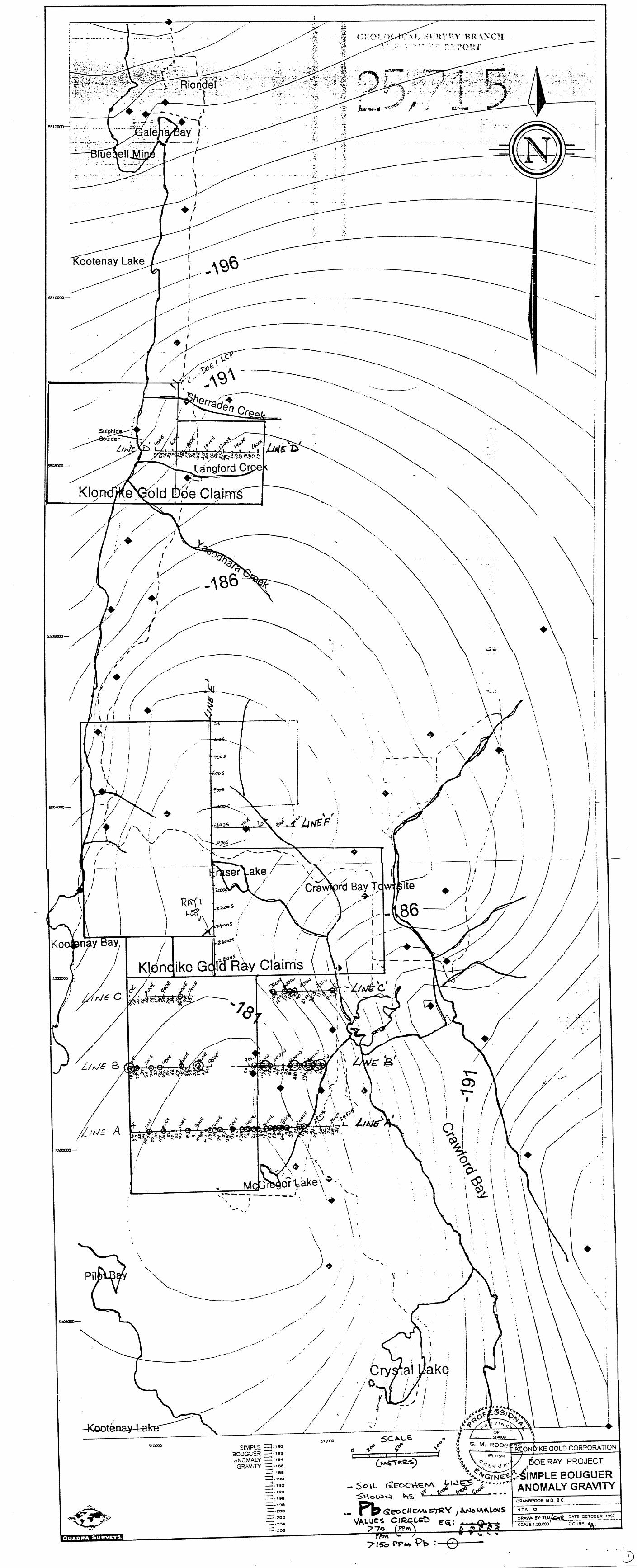
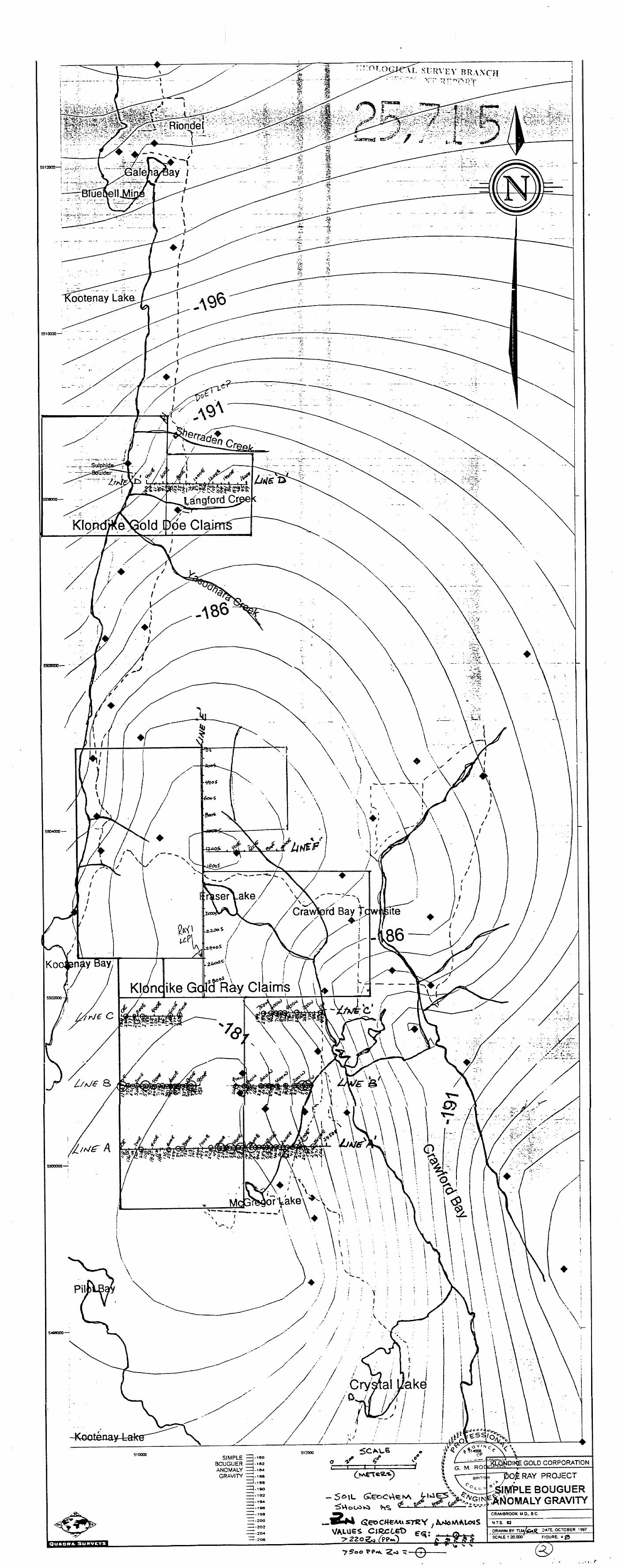
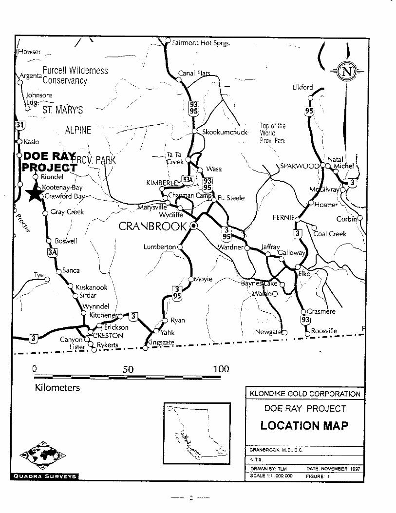
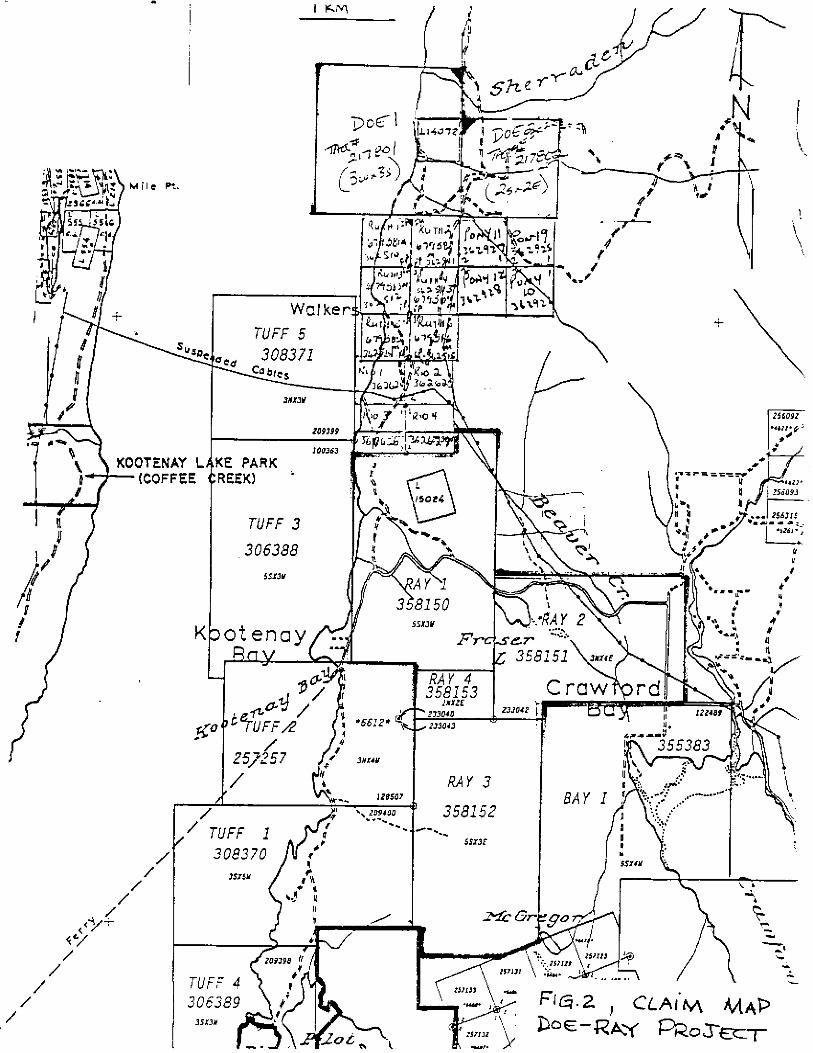
Fig.1 (Location Map) (l:l,OOO,OOO) 2 Fig.2 (Claim Map) (I:3 1,680) 3 Fig.3 (General Geology) (1:250,000) 4 Fig.4A (Gravity plot with Pb Geochemistry) In pocket Fig.4B (Gravity Plot with Zn Geochemistry) In pocket
Page 1 1 1 1
5 5
5
6
38
38
39
1 .O JNTRODUCTION
1.1 Location and Access The property covers the Crawford Bay Peninsula as well as the area near
the mouth of Sherredon Creek located 3-8km south ofRionde1, B.C.. Access is via good paved roads from Creston, B.C. or via ferq from Nelson, B.C.
1.2 Claim Status The property consists of 57 units in two blocks (Doe and Ray). The claims were
considered as one property for the sake of the graviity survey.
Claim Name Tenure # # of units Doe1 358996 9 Doe2 358997 4 &Yl 358150 15 Ray2 358151 12 Ray3 358152 15 bY4 358153 2
Expiry Date Sept.6,1999
“ ** “
July 31,1999 Aug.1,1999
I‘ >> “ “ v* “
1.3 History
The area is most famous for hosting the Bluebell deposit which produced over 5.3 million tons of 4.9%Pb, S.Z%Zn, 1.3odt Ag. Several large boulders of sulphide ore are found scattered on the claims including one large boulder on the Doe claims which was actually mined (450 tons Pb,Zn, Ag). Previous workers have conducted HLEM and other surveys over the area, drilled anomalies, but never found the source of the boulders or the Pb/Zn anomalies in soil and rock.
1.4 Objectives of the Present Program
The objectives of the 1997 program were to see if gravity would dehneate any areas of density contrast that could be interpreted as massive sulphide. The geochemical program was designed to look for East-West and North-South structures that may be mineralized.
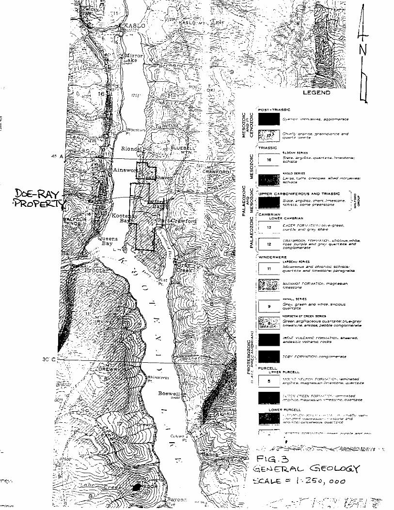
2.0 GEOLOGY
2.1 Regional Geology The property area lies within the Pb,Zn metallogenic province known as
the Kootenay Arc which consists of Late Proterozoic to Early Paleozoic age strataform and stratabound limestones and dolomites. Rocks on the property consist of north-trending and west- dipping succession of Lower Cambrian quattzites, pelitic schists, calcareous schists, and marble.
Three kilometers north of the property lies the Bluebell deposit which produchd over 5.3 million tons of 4.9??Pb, 5.2%Zn and 1.3oAAg.
2.2 Property Geology The property is underlain by limestone and dolomite of the upper
Proterozoic Badshot Formation as well as graphitic schist, chloritic schist quart&es and a gneissic package of the Lardeau Series. Occasional granodiorite intrusions are seen on the claims and these have locally altered the intruded limestones to marble.
The property contains several float boulders of massive sulphide float that could have either come down-ice from the Bluebell deposit or may have not traveled far f?om a buried local source.
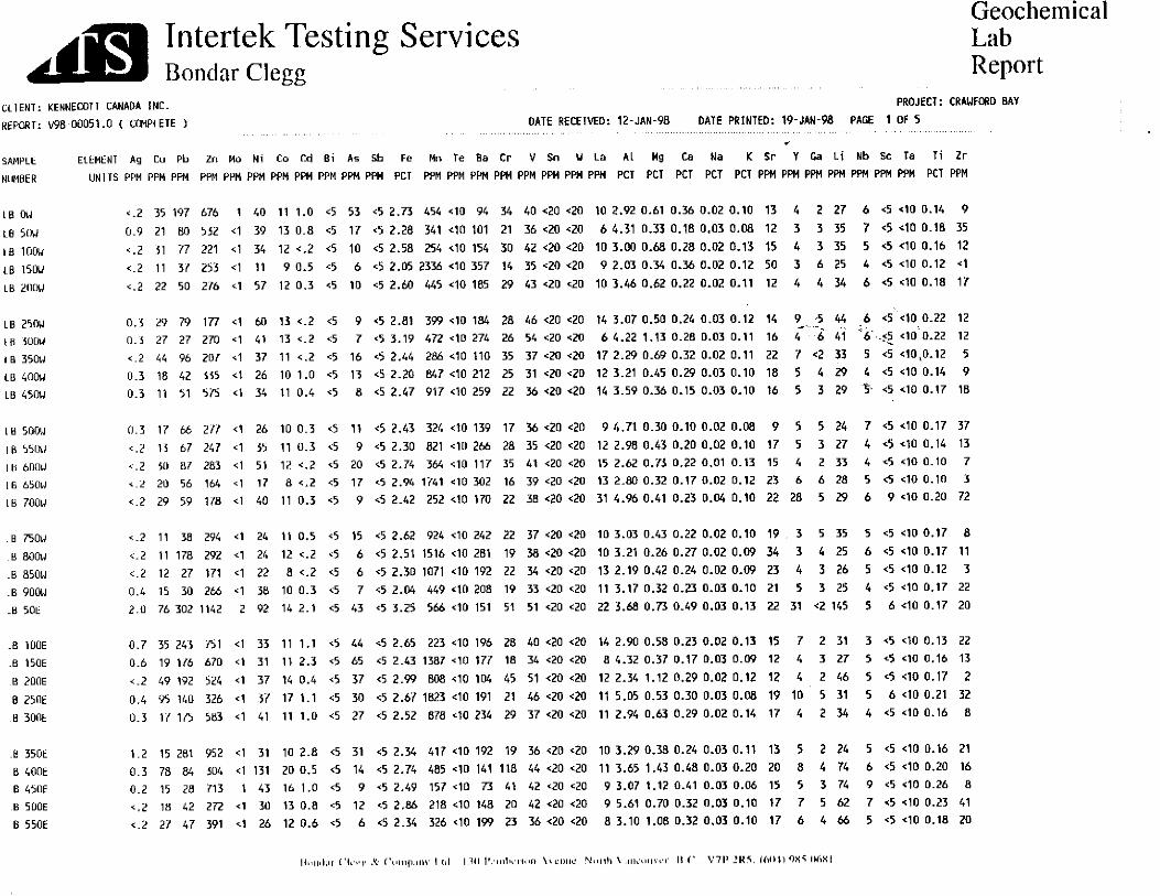
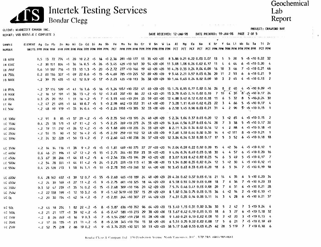
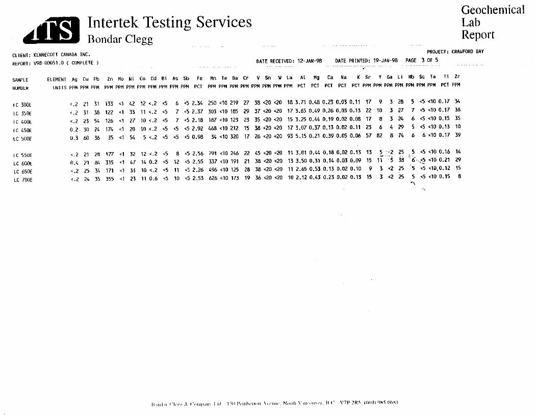
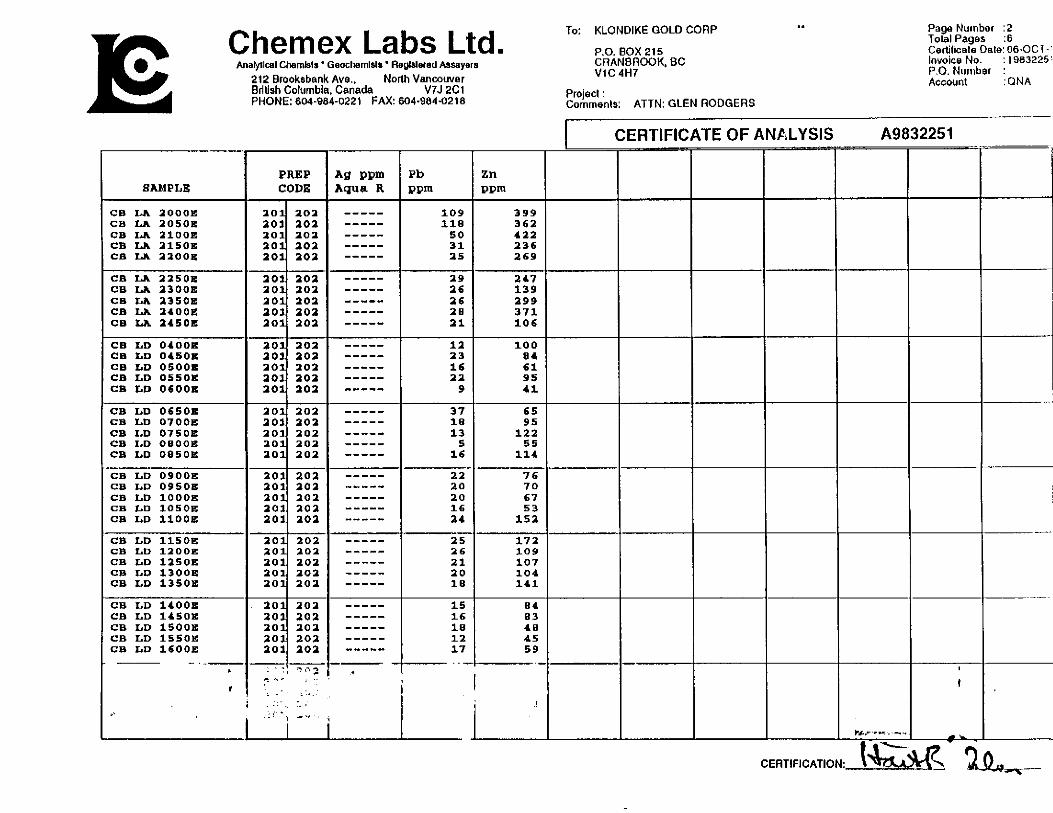
3.0 GEOCHEMISTRY
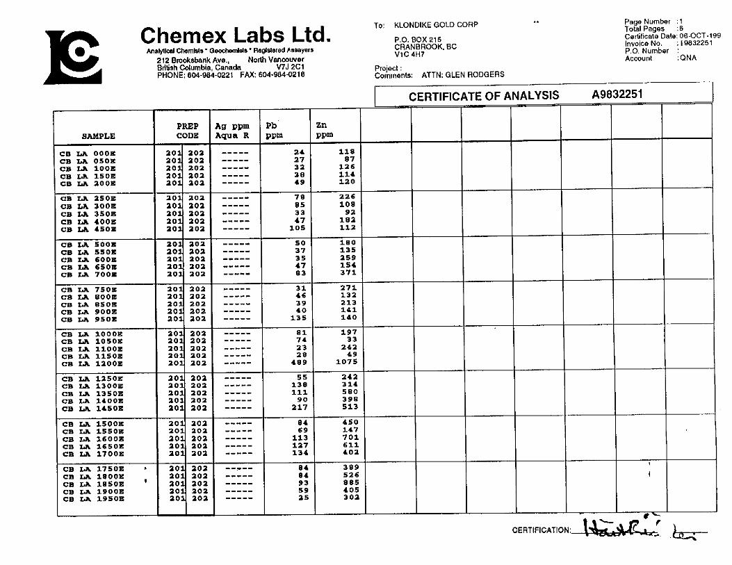
3.1 Soil Sampling Program and Results Soil sample sites were chosen to show any mineralized North-South or
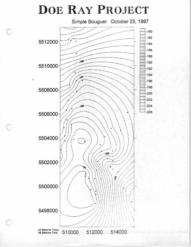
East-West structures. A total of 290 samples were taken but only samples were submitted to Bondar-Clegg (Intertek Testing) for 32 element geochemical analysis. Figure 4 (in pocket) shows soil sample locations (Limes A-D). Anomalous values in this area are known from previous work to be greater than 70 ppb for Pb and greater than 220 ppm for Zn. These values are higher than normal due to the carbonate terrain Anomalous results are circled in fig.4 but are not contoured due to the large line spacing.
Results show that more than half the samples assayed were anomalous in Zinc and at least 25% of the samples were anomalous in Pb.(see fig.4)
Samples were taken from the “B” soil horizon at depths of lo-20cm from surface. Samples were sent to Chemex Labs Ltd. For analysis. Samples were sieved to -80 mesh and digested using aqua-regia solution. They were analyzed for ppm Pb,Zn and Ag using Atomic Absorption techniques.
(6)
4.0 Gravity Report
SUMMARY REPORT
on a
GRAVITY SURVEY conducted on the
DOE RAY PROJECT Near Nelson, British Columbia
PROPERTY
SURVEY PERIOD
WRITTEN FOR
: Northeast of Cranbrook, British Columbia : UTM Zone 11 Easting: 509000 - 5 16000 : UTM Zone 11 Northing: 5496000 -55 14000
: October 24 to October 25,1997
: Klondike Gold Corporation 1000 - 675 West Hastings Street Vancouver, British Columbia, V6C 1 S4
WRITTEN BY
DATED : November 5,1997
: Tam Mitchell, AScT QUADRA SURVEYS 2-8640 Blundell Road Richmond, British Columbia, V6R 1Kl
SUMMARY
A regional gravity survey was conducted in the Crawford Bay area. The property hosts a
geological terrain known to be prospective for sedex type deposits. The purpose of the work
was to define possible mineralized zones and geologic structures in the area.
The gravity survey was conducted with 4WD access on existing roads. Gravity measurements
were carried out using a Scintrex gravity meter. The station locations were obtained with a
real time Ttimble double differential GPS survey system. Inclinometer readings were taken at
every station to a distance of 170 meters for terrain corrections.
The gravity data were corrected for the various influences to yield partial Bouguer gravity
anomaly values listed herein.
TABLE OF CONTENTS
Introduction 1
Location Map 2
Location and Access 3
Survey Procedure 3
Instrumentation 5
Data Reduction and Formulae 6
Results & Interpretation 8
Survey Precision 8
References 9
Statement of Qualifications 10
Appendices
Gravity & GPS Base Stations.
Table of Field Notes, Calculations & Gravity Values
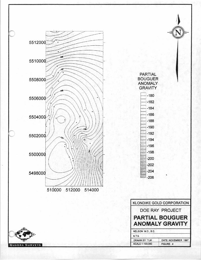
Partial Bouguer Anomaly Plan Map
Illustrations
Figure 1 - Location Map - Scale 1:1,000,000
Figure 2 - Cira\jityBase Station
Figure 3 - GPS Base Stations
MAPS
Location Map
Figure I Scale 1: 1 ,OOO,OOO
Partial Bouguer Anomaly Plan Map
Figure 5 Scale 1: 100,000
I
II
III
2
Appendix I
Appendix I
2
Appendix III
INTRODUCTION
.4t the request of Klondike Gold Corporation a gravity survey was conducted in the Crawford
Bay area, East-Northeast of Nelson BC. This report describes the instrumentation, theory,
field procedure, data reduction and results of the 2 day survey which commenced October 24
and was completed October 25: 1997.
The survey was conducted by Tam Mitchell, AscT of Richmond, BC with the assistance of
Zyoji Jackson of Cranbrook, BC. The crew was based at the Hastings Management field
office at 3380 Wilks Road in Cranbrook, but stayed at Nelson, BC while acquiring data. The
explorafon program was carried out under the field supervision of Glen Rodgers of
Klondike Gold Corporation.
The main purpose of the survey was to identify geologic structures in the area to locate
possible zones of sedex type mineralization. Gravity surveying is a very effective tool in
locating lead and zinc mineralization, particularly because of the high specific gravity of any
sulphide mineralization especially that of lead.
- I-
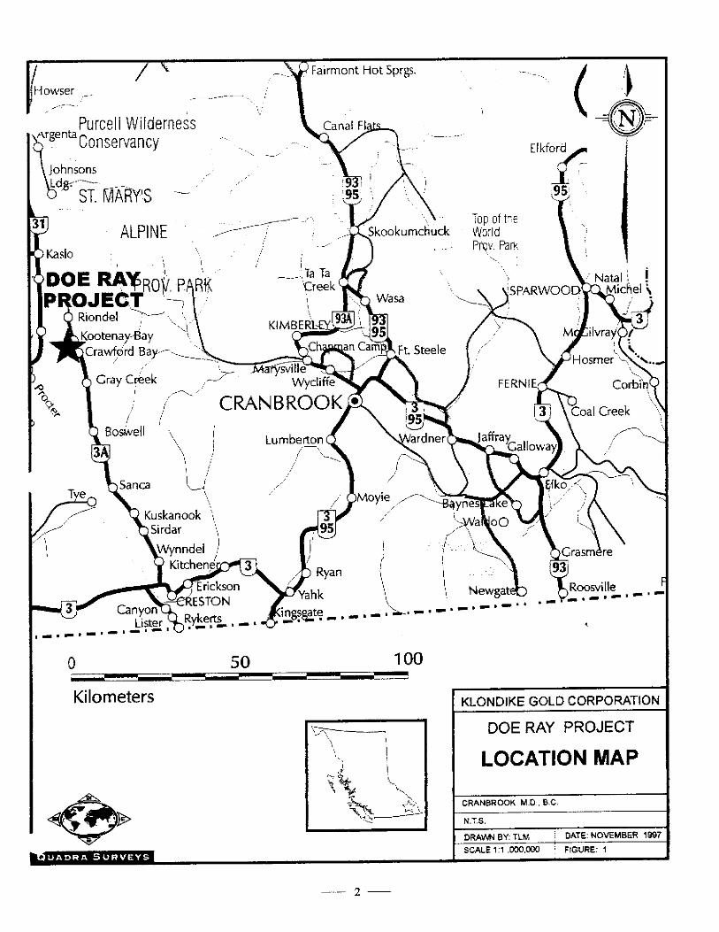
LOCATION and ACCESS
The property is located 30 km. to the East-Northeast of Nelson approximately defined by
UTM Zone 11; Easting: 509000 to 5 16000 and Northing: 5496000 to 55 14000. See figure 1.
Access to the property was primarily on existing roads and logging roads accessible from
Highway No. 3A at Crawford Bay,
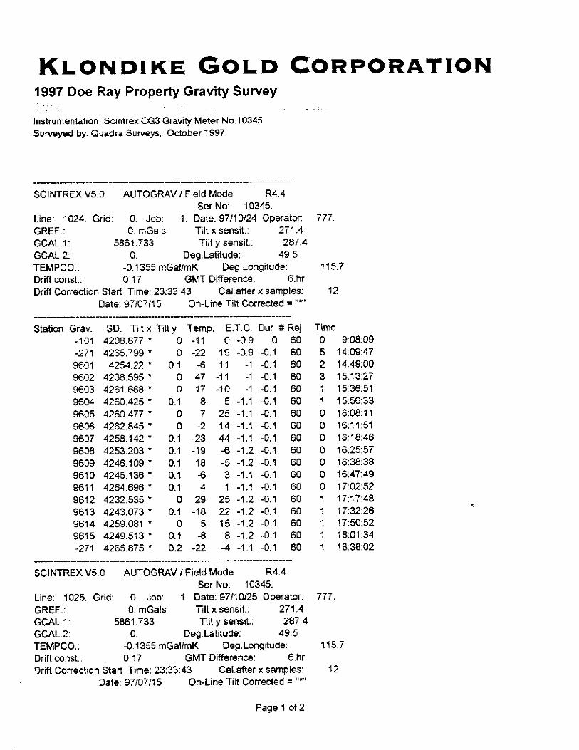
SURVEY PROCEDURE
All gravity readings were tied to the National Gravity Net by a gravity base station
established in a 1996 gravity survey. The base is located at the Cranbrook field office at 3380
Wilks Road and is marked by a steel spike and identified by a wooden stake with an
aluminum tag reading: “Gravity Base -101”. Geographic coordinates for the station were
derived by GPS measurements as 49O 32’ 48.07384” N and 11S’ 48’ 44.86830” W (see
figure 2). The station has a National Gravity Net value of 980688.13 &I.02 mgal. Field ties
were also made to the nearest field base used for the GPS base station.
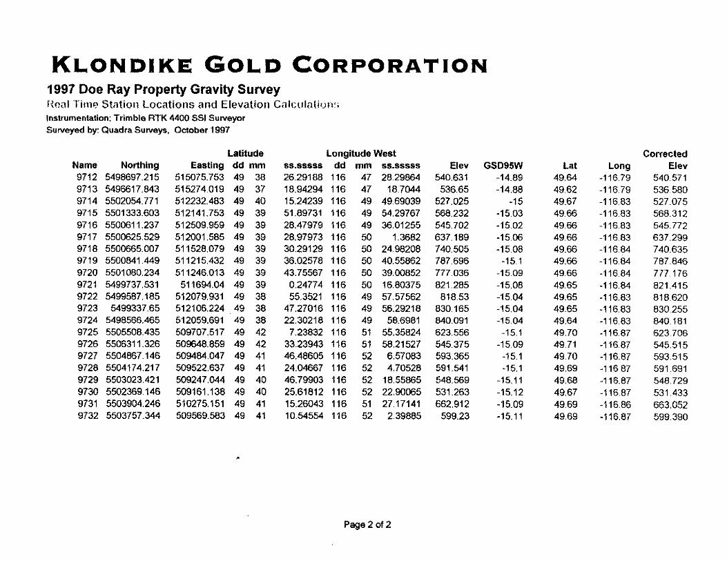
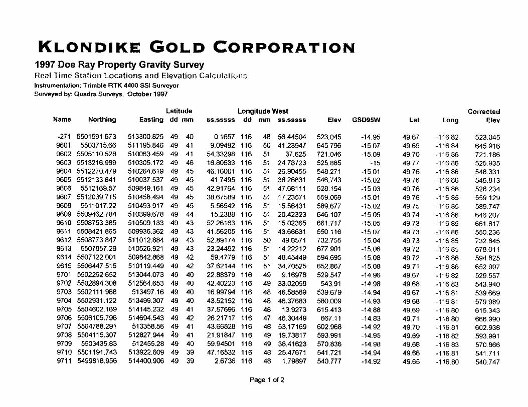
All Survey locations were referenced to a control point identified as -271. The coordinates
for this station were obtained by an autonomous GPS fix. The station is further described as
fellows:
Nad 83 Northing 5501591.673 m Approximate only
Nad 83 Easting 513300.825 m Approximate only 1
CVD28 Elevation 523.045 m Approximate only
Tam Mitchell, AScT, of Richmond BC, with the assistance of Zyoji Jackson of Cranbrook
BC acquired the field data. A total of 48 stations were acquired during the 2 days of the
survey.
The gravity survey was conducted with 4WD on existing logging roads and public access
roads.
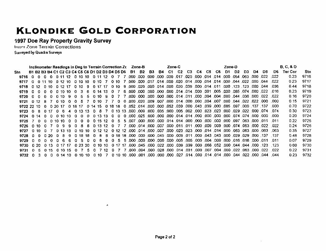
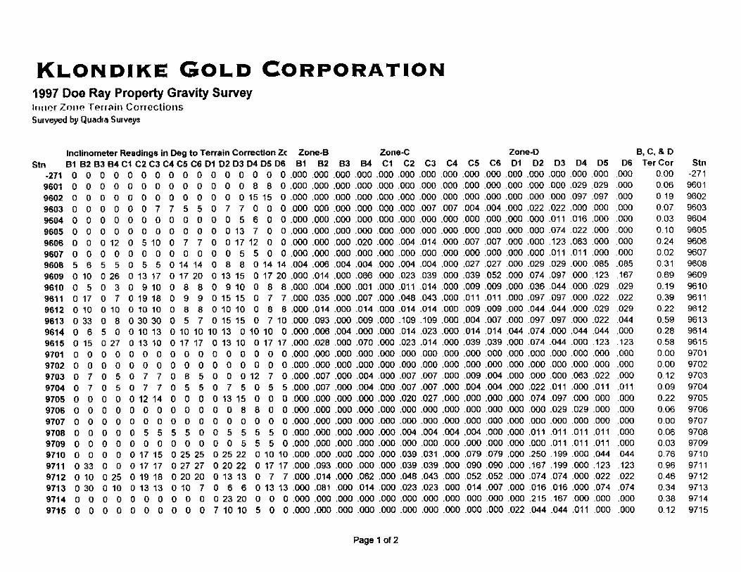
Inclinometer readings were taken on each gravity station with a Suunto inclinometer to
provide inner zone terrain corrections in accordance with the Hammer Chart method. Zone B
inclinometer readings were taken at 0, 90, I SO and 270 at a distance of 9.3 meters from the
station. Zones C and D were shot at 0,60, 120, 180, 240, and 300 degrees at distances of 35
and 112 meters respectively. Distances and angles were estimated.
-4-
INSTRUMENTATION
GRAVITY
The gravity readings were taken with a Scintrex CG-3 gravity meter (serial no. 10345)
manufactured in Concord Ontario. The instrument has a world wide calibration range of over
7,000 mgal and a reading resolution of 0.005 mgal. This instrument features a sensor based
on a fused quartz elastic system. The proof mass is balanced by a spring and a relatively
small electrostatic restoring force. The position of the mass, which is sensed by a capacitative
displacement transducer, is altered by a change in gravity The inherent strength and elastic
properties of the fused quartz together with stop limits around the proof mass permit the
instrument to be operated without clamping. Instrument drift is considerably reduced by
precise thermostatic control of the unit and software correction for residual effects. The
instrument’s tilt sensors are analog as well as electronic with a resolution of 1 arc second.
Real time corrections for tilt errors can be automatically made for a range of -i 200 arc
seconds. The entire gravity sensing mechanism is enclosed in a vacuum chamber to provide
isolation from variations in atmospheric pressure. This extremely stable operating
environment allows the long term drift of the sensor to be accurately predicted, and real time
software correction reduces it to less than 0.02 mGals/day in theory The unit can also
automatically compensate for earth tides. The ETC is generated using the Longman formula
(gravimetric factor 1.16).
SURVEYING
Station locations were surveyed using the Trimble Site Surveyor 4400 system with a Pacific
Crest radio link. The system used was capable of post-processing rapid static meas$ements
with an accuracy of i5 mm +lppm horizontal and il cm + lppm vertical or real time data
acquisition with an accuracy rating of + 1 cm +2ppm horizontal and i2 cm + 2ppm vertical.
The Site Surveyor 4400 is based on Trimble’s fourth generation real-time survey technology.
Incorporating the latest Trimble real-time GPS engine code and solution alogrithms, the
system provides very fast on-the-fly (OTF) initializations with the industry’s most reliable
position results. With this technology, average initialization times are cut in half. With
advanced satellite signal acquisition and tracking, the ability to survey near trees is enhanced
and downtime due to loss of signal minimized.
-5-
DATA REDUCTION and FORMULAE
The gravity data was processed by computer in the following manner:
g. Observed Gravity- field observations corrected for earth tides and long term
instrument drift were downloaded from electronic storage in the gravity meter and
corrections made for instrument height and residual instrument drift. These values
were then tied to the National Gravity Net.
gfa Free Air Effect- Correction for relative distances of observation points from the
centre of mass(earth). This calculation moves all stations to a common elevation
datum and corrects for relative distances in distance from the source mass. The
elevation datum used was CGVD 28 mean sea level. The formulae used was:
gr.= -0.3086 meal/m
as Jbuger Slab Effect - Correction for the relative differences in amounts of surface
rock below gravity stations. This calculation requires that a mean density or rock type
between the lowest and highest grid elevations be established. All stations are shifted
to a common datum as ins the free air effect except that the vertical change is through
an assumed slab of the derived density. The elevation datum used was CGVD 28
mean sea level.
gb= 2*PI*.O0667*0 mgaUm 3
Where 0 = slab density @m/cc)
a Theoretical Gravity - Yields correction for change of observed gravity with change
in latitude which is due primarily to the rotation of the earth and the difference in
earth’s radius between the poles and the equator.
g = gp( I + asin 0+ psin’26)
Where g, = equatorial brevity = 978,031.85 mgal.
a = 0.005278895
p = -0.000023462
0 = Latitude
% Terrain Correction- corrections for variations caused by local terrain. The vertical
component of the gravitational effect exerted by nearby hills, or not exerted by nearby
vafleys or gullies; will effect the net reading obtained on any one station. The overall
effect on a given line profile or area will be a function of the station spacing relative
to the frequency of terrain undulations. Areas were segmented using circular sectors
in zones developed by Hammer (1939). Corrections were made for zones B, C, and D
(covering an area from 2 to 170 meters from the station).
g, was calculated from the following expression:
g, = C@to[r, - ri 7 (r,? + 2)" - (rO’ + z2)“]
Where @ = Sector angle (B = 90”, C & D = 60 “)
r = gravitational constant = 0.00667
cr = average density (gmkc)
r, = outer sector radius (B=16.6, C=53.3, D=170)
ri = inner sector radius (B=2, P16.6, D=53.3)
z = elevation difference between sector and station
e3.a Free Air Anomaly: is derived from the following formulae:
gf,= g. - (g,-O.3086*E) = Free Air Anomaly
Where g. = observed gravity
g; = theoretical gravity
E = CGVD 28 elevation
gb. Bouguer Anomaly: was derived from the following formulae:
gt,. = gb + grm + gr = Bouguer Gravity
Where gb = Bouguer gravity
&a = free air anomaly
g, = terrain corrections
-7-
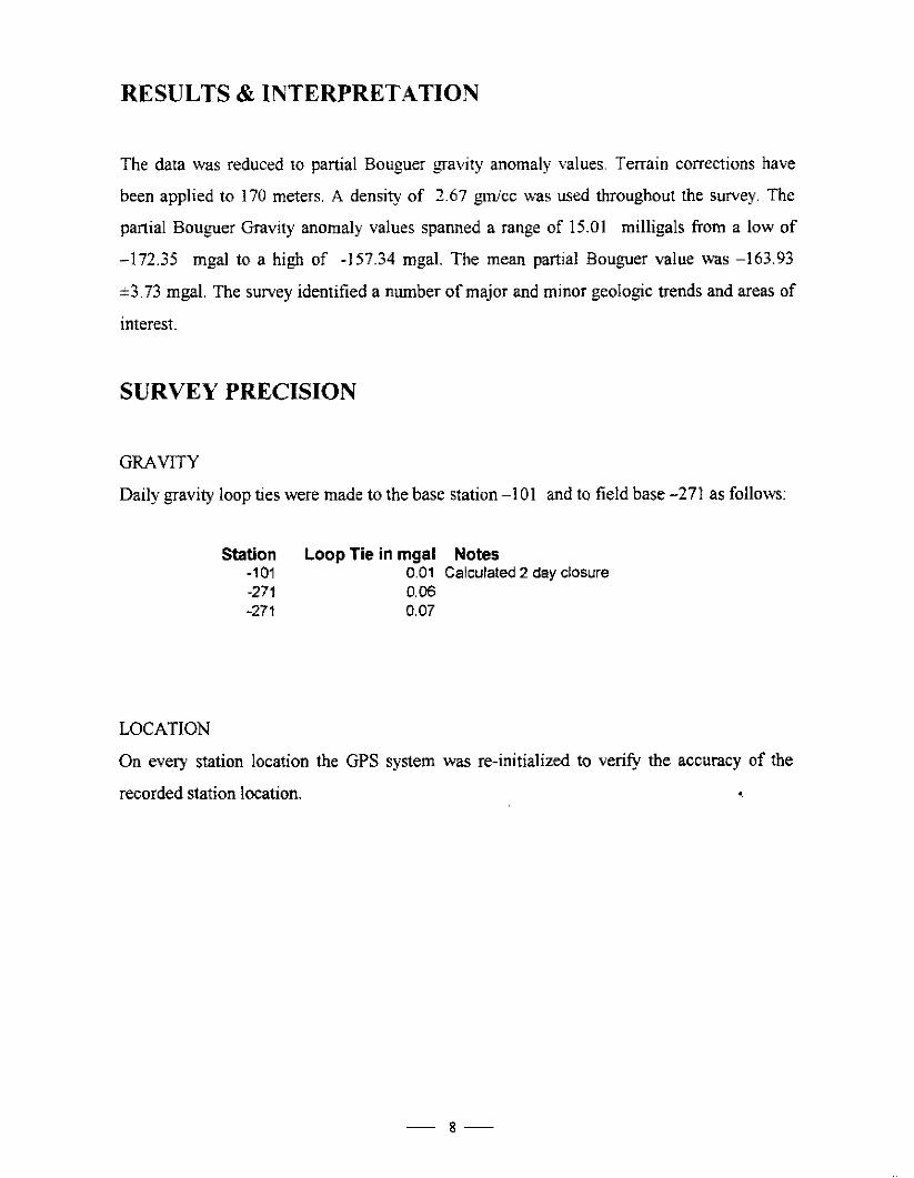
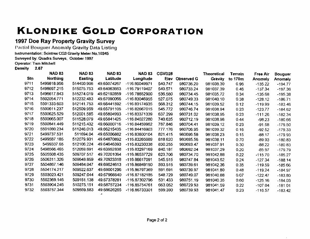
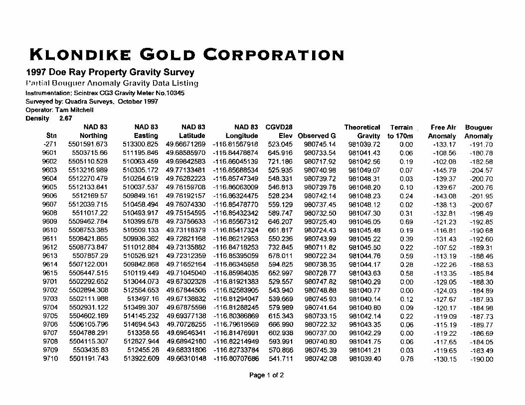
RESULTS & INTERPRETATION
The data was reduced to partial Bouguer gravity anomaly values. Terrain corrections have
been applied to 170 meters. A density of 2.67 gmkc &as used throughout the survey. The
partial Bouguer Gravity anomaly values spanned a range of 15.01 milligals from a low of
-172.35 mgal to a high of -I 57.34 mgal. The mean partial Bouguer value was -163.93
e3.73 mgal. The survey identified a number of major and minor geologic trends and areas of
interest.
SURVEY PRECISION
GRAVITY
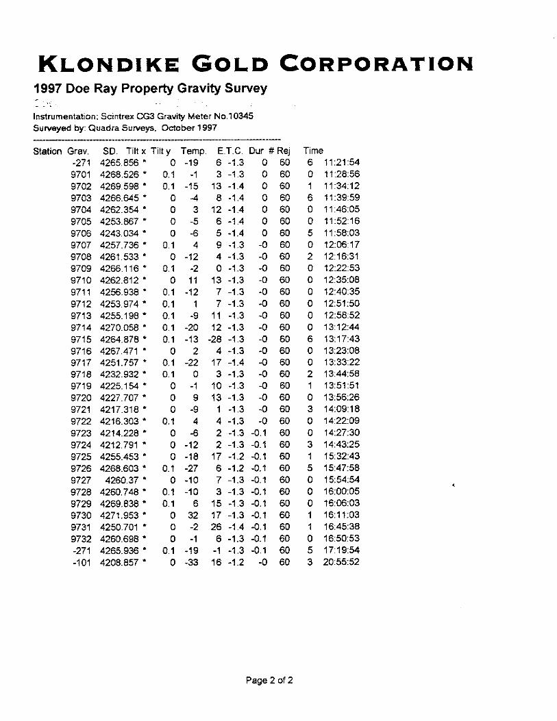
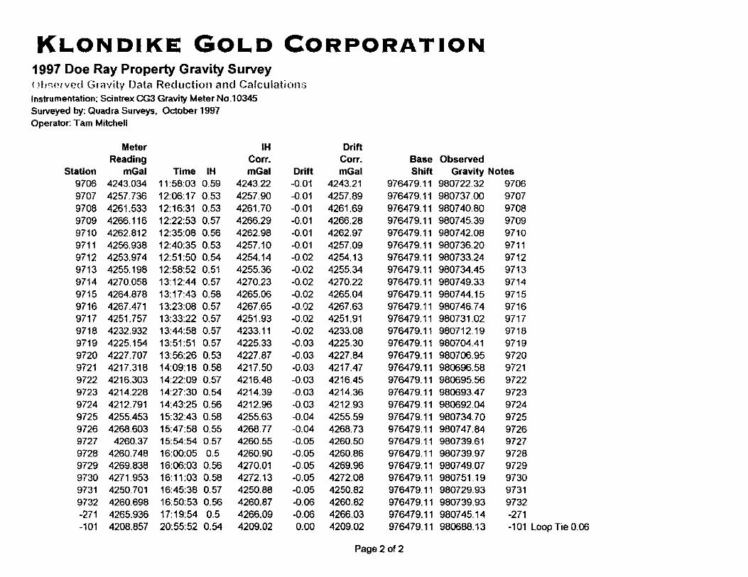
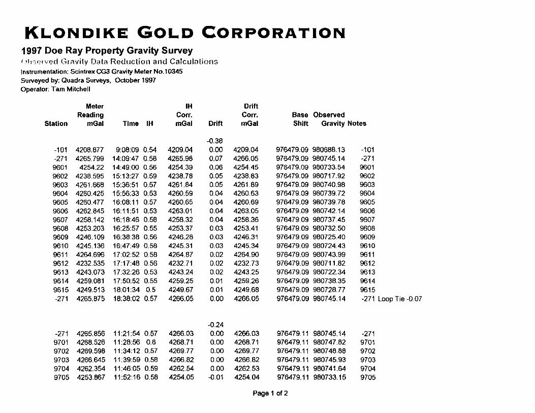
Daily gravity loop ties were made to the base station -101 and to field base -271 as follows:
Station Loop Tie in mgal Notes -101 0.01 Calculated 2 day closure -271 0.06 -271 0.07
LOCATION
On every station location the GPS system was re-initialized to verify the accuracy of the
recorded station location. I
-8-
REFERENCES
Lacoste & Bomberg Instruction Manual, Model G and D Gravity Meter, June 1989
Seigel, H.O.; A Guide to High Precision Land Gravimeter Surveys, August 1995
Telford, W. M., Geldart, L. P.; Sheriff, R. E., Keys, D. A.; Applied Geophysics, 1982
Longman, I. M.; Journal of Geophysical Research, Volume 64, hlo. 12; Formulasfor
Computing the Tidal Accelerations Due to the Moon and Sun, December 1959
Hammer, 1939; (Terrain Correction Model)
-9-
STATEMENT OF QUALIFICATIONS
I Thomas L. Mitchell, AScT, of the city of Richmond, Province of British Columbia, DO HEREBY CERTIFY THAT:
1. I am the owner of Quadra Surveys with office at 2-8640 Blundell Road, Richmond,
British Columbia, V6R 1Kl.
2. 1 am a graduate of BCIT, with a diploma in Surveying Technology (1977).
3. 1 am a geophysical surveyor, registered with the Association of Applied Science
Technologists and Technicians of British Columbia.
4. I have practiced my profession in Africa, Canada, Japan and USA for 19 YWS
5. This report is based on a gravity survey which I conducted.
6. I have no direct or indirect interest in the property nor do I expect to receive any.
Dated at Cranbrook, British Columbia, this 5ti day of November, 1997.
APPENDIX I
Gravity & GPS Base Stations
APPENDIX II
Partial Bouguer AnomaIy Gravity Data Listing
Real Time GPS Station Locations and Elevation Calculations
Observed Gravity Values - Electronic Notes from Gravity Meter
Observed Gravity Data Reduction and Calculations
Inner Zone Terrain Corrections
APPENDIX III
Partial Bouguer Anomaly Plan Map
5.0 CONCLUSIONS AXD RECOMMENDATIONS
Soil samples that were submitted for geochem analysis show areas of very anomalous Pb and Zn. Gravity results show a large anomalous area that underlies the northern half of the Crawford Bay Peninsula as well as a secondary anomaly north of the highway.
Other soil samples collected should also be run for 32 element geochem. Follow-up prospecting with rock sampling should be done over all anomalous area as well as geological mapping.
6.0 STATEMENT OF QUALIFICATIONS
This is to certify that I, Glen M. Rodgers, PEng. ;
-am a graduate of the University of Manitoba with a Bsc. in Geological Engineering (1977).
-am a member in good standing of the British Columbia Association of Professional Engineers and Geoscientists (P.Eng.).
-have practiced my profession over the last 22 years working as a geologist and engineer in B.C., Yukon, NWT., Alaska and Central America.
-base this report on first hand experience on the Doe-Ray property and do not expect to receive any shares of Rlondike Gold Corp. as a result of writing this report
(39)
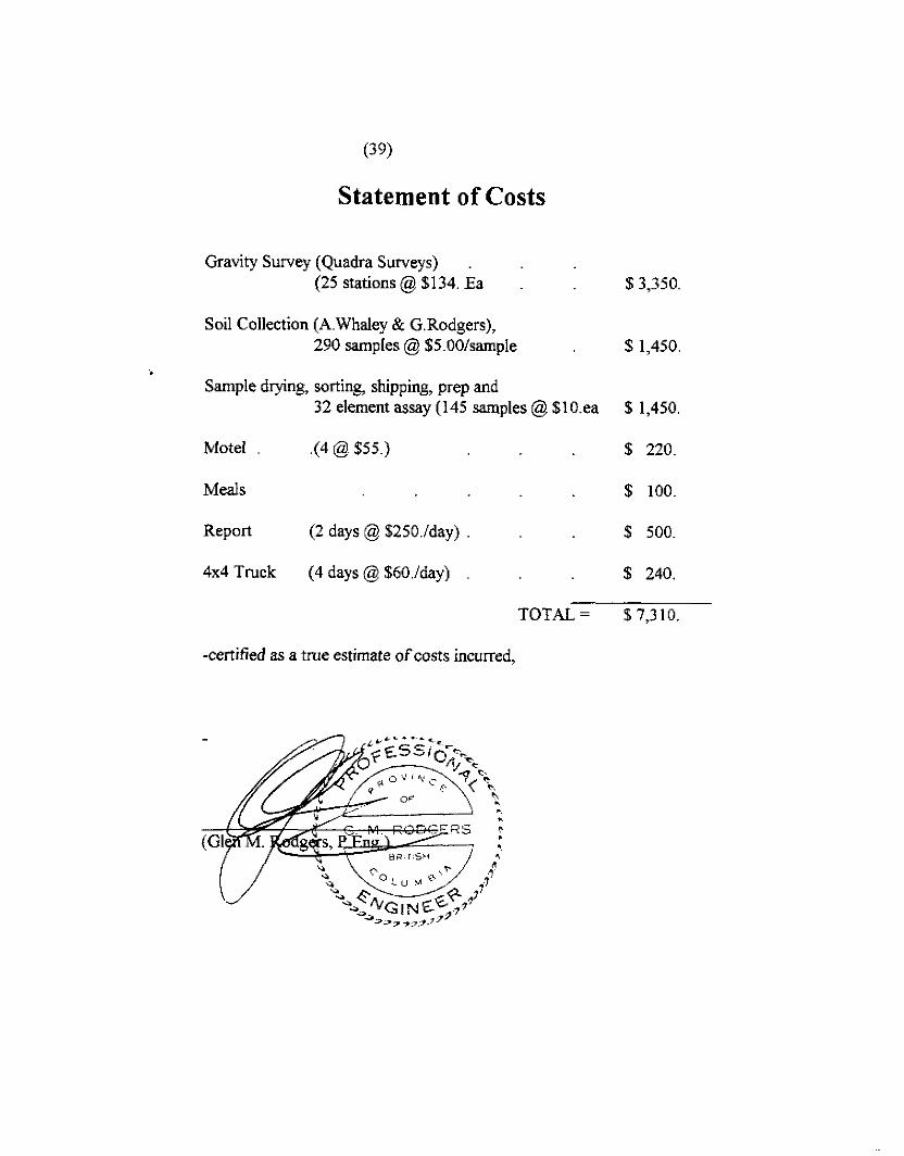
Statement of Costs
Gravity Survey (Quadra Surveys) (25 stations @ $134. Ea : 1 $ 3,350.
Soil Collection (A.Whaley & G.Rodgers), 290 samples @ %S.OO/sample % 1,450.
Sample drying, sorting, shipping, prep and 32 element assay (145 samples @ $lO.ea $ 1,450
Motel .(4@$55.) $ 220
Meals $ 100
Report (2 days @ $25O./day) 16 500
4x4 Truck (4 days @ $6O./day) % 240.
TOTAL = $7,310.
-certified as a true estimate of costs incurred.