Embed Size (px)
Citation preview
1
GEOPHYSICAL INVESTIGATION OF A SUSPECTED IMPACT CRATER,
LIBERTY TOWNSHIP, SENECA COUNTY, OHIO
Donald J. Stierman Bradley B. Trytten1
Scott Gurney Department of Earth, Ecological & Environmental Sciences - The University of Toledo
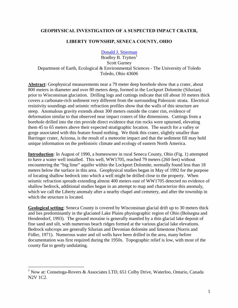
Toledo, Ohio 43606 Abstract: Geophysical measurements near a 79 meter deep borehole show that a crater, about 800 meters in diameter and over 80 meters deep, formed in the Lockport Dolomite (Silurian) prior to Wisconsinan glaciation. Drilling logs and cuttings indicate that till about 10 meters thick covers a carbonate-rich sediment very different from the surrounding Paleozoic strata. Electrical resistivity soundings and seismic refraction profiles show that the walls of this structure are steep. Anomalous gravity extends about 300 meters outside the crater rim, evidence of deformation similar to that observed near impact craters of like dimensions. Cuttings from a borehole drilled into the rim provide direct evidence that rim rocks were upturned, elevating them 45 to 65 meters above their expected stratigraphic location. The search for a valley or gorge associated with this feature found nothing. We think this crater, slightly smaller than Barringer crater, Arizona, is the result of a meteorite impact and that the sediment fill may hold unique information on the prehistoric climate and ecology of eastern North America. Introduction: In August of 1990, a homeowner in rural Seneca County, Ohio (Fig. 1) attempted to have a water well installed. This well, WW1705, reached 79 meters (260 feet) without encountering the “big lime” aquifer within the Lockport Dolomite, normally found less than 18 meters below the surface in this area. Geophysical studies began in May of 1992 for the purpose of locating shallow bedrock into which a well might be drilled close to the property. When seismic refraction spreads extending almost 400 meters east of WW1705 detected no evidence of shallow bedrock, additional studies began in an attempt to map and characterize this anomaly, which we call the Liberty anomaly after a nearby chapel and cemetery, and after the township in which the structure is located. Geological setting: Seneca County is covered by Wisconsinan glacial drift up to 30 meters thick and lies predominantly in the glaciated Lake Plains physiographic region of Ohio (Bolsegna and Hendendorf, 1993). The ground moraine is generally mantled by a thin glacial lake deposit of fine sand and silt, with numerous beach ridges formed at the various glacial lake elevations. Bedrock subcrops are generally Silurian and Devonian dolomite and limestone (Norris and Fidler, 1971). Numerous water and oil wells have been drilled in the area, many before documentation was first required during the 1950s. Topographic relief is low, with most of the county flat to gently undulating.
1 Now at: Consetoga-Rovers & Associates LTD, 651 Colby Drive, Waterloo, Ontario, Canada N2V 1C2.
2
Anomalous geology: Paleozoic stratigraphy near WW1705 (Table 1 and Fig. 2a), based on information from a continuously cored hole drilled about 7 km to the northeast, in Section 12 of Liberty Township (Wickstrom et al., 1985), is consistent with all water and oil well logs except for five locations in Sections 17 and 20, just to the east of State Route 635 (Table 2). Wells WW1701, WW1704 and WW1705, all drilled in essentially the same location, report no evidence of carbonate bedrock. Wells WW2005 and SW report "rock" but not the "lime" recorded on many other well logs, as well as gray shale and red shale or red rock. Well WW2006 reports limestone interbedded with mud. A handful of
cuttings was collected from both WW2006 and WW1705. Only from WW1706 were numerous samples collected, labeled and preserved.
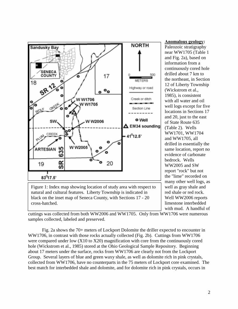
Fig. 2a shows the 70+ meters of Lockport Dolomite the driller expected to encounter in WW1706, in contrast with those rocks actually collected (Fig. 2b). Cuttings from WW1706 were compared under low (X10 to X20) magnification with core from the continuously cored hole (Wickstrom et al., 1985) stored at the Ohio Geological Sample Repository. Beginning about 17 meters under the surface, rocks from WW1706 are clearly not from the Lockport Group. Several layers of blue and green waxy shale, as well as dolomite rich in pink crystals, collected from WW1706, have no counterparts in the 75 meters of Lockport core examined. The best match for interbedded shale and dolomite, and for dolomite rich in pink crystals, occurs in
Figure 1: Index map showing location of study area with respect to natural and cultural features. Liberty Township is indicated in black on the inset map of Seneca County, with Sections 17 - 20 cross-hatched.
3
the Rochester and Dayton Formations. If this interpretation is correct, strata encountered in WW1706 lie 45 to 65 meters above their normal position.
Table 1: Rock units encountered in a continuously cored hole drilled in Section 12, Liberty Township, Seneca County, by the Ohio Geological Survey (Wickstrom et al., 1985). Elevation and depth are values projected to Section 17, based on an eastward dip of 6.6 meters/kilometer.
Rock Unit Elevation of base, MSL (m)
Depth to base (m)
Lithology
Lockport 146 75 Dolomite Rochester 143 78 Dolomite & shale
Dayton 138 83 Dolomite & shale Cabot Head 107 114 Shale & dolomite Brassfield 100 121 Dolomite Queenston 80 141 Shale Whitewater 37 184 Limestone Cincinnatian -176.5 397.5 Shale
Trenton -216 437 Limestone Black River -380 601 Limestone
Cuttings from WW1705 and WW2006
resemble neither the Paleozoic rocks of this area nor the glacial till. These cuttings react vigorously with dilute HCl, but only the matrix of these sedimentary rocks is calcium carbonate. One air-dried sample was weighted and then allowed to react with HCl until all of the calcium carbonate was gone. This sample was washed with distilled water, filtered, air-dried and reweighed. It lost 14% of its mass as a result of this treatment. The dried sample cracked, suggesting some clays are present in addition to the relatively uniform, rounded silt particles observed under low (x10 to x20) magnification as HCl destroyed the carbonate cement. This sediment suggests a low-energy depositional environment such as a lake. Carbonate cement suggests ground water discharge from a limestone or dolomite aquifer into this lake, as it does near underwater springs where marls are forming in Sandusky Bay (Fig. 1).
Figure 2: Lithology expected (a) contrasted with that encountered (b) in WW1706. Gaps in column (b) occurred where no samples were collected.
4
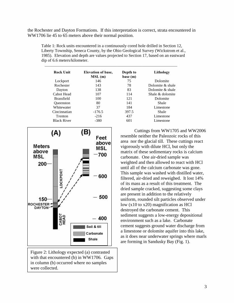
Geophysical measurements were used to investigate areas where boreholes do not provide an opportunity to observe directly what lies concealed by the till of western Liberty Township. Gravity, electrical resistivity, electromagnetic conductivity, and seismic refraction each play a role in delineating the Liberty structure and revealing more of its morphology. Gravity: The Liberty structure lies on the flank of the Seneca gravity anomaly (Lucius and Von Frese, 1988), a gravity 30 milligal high about 30 km in diameter (Fig. 3). We occupied about 340 new gravity stations to better delineate both the Seneca anomaly and the Liberty structure. Elevation control relied on spot elevations from topographic maps for regional work. An electronic total station provided elevation control for most stations occupied near the Liberty structure. Differential GPS was used to obtain map coordinates during the most recent phase of gravity fieldwork.
Because of the low topographic relief, the simple Bouguer anomaly was deemed
sufficient for this investigation. Fig. 4 shows station distribution and the simple Bouguer anomaly in and around the anomalous wells (Fig. 1). There is a local gravity low, but the boundaries remain unclear because of the 2.5 milligal/km slope of the Seneca anomaly (Fig. 3). In order to separate the "regional" gravity (including, in this case, the Seneca anomaly) from the gravity signature of the Liberty structure, observations surrounding the Liberty structure were fit
Figure 3: Surface plot of the Seneca gravity anomaly (Lucius and Von Frese, 1988). Arrow shows approximate location of the Liberty structure.

5
with a fourth order polynomial in a least-squares sense (see Appendix A) and the coefficients used to calculate "regional" gravity at all stations shown in Fig. 4. Residual gravity
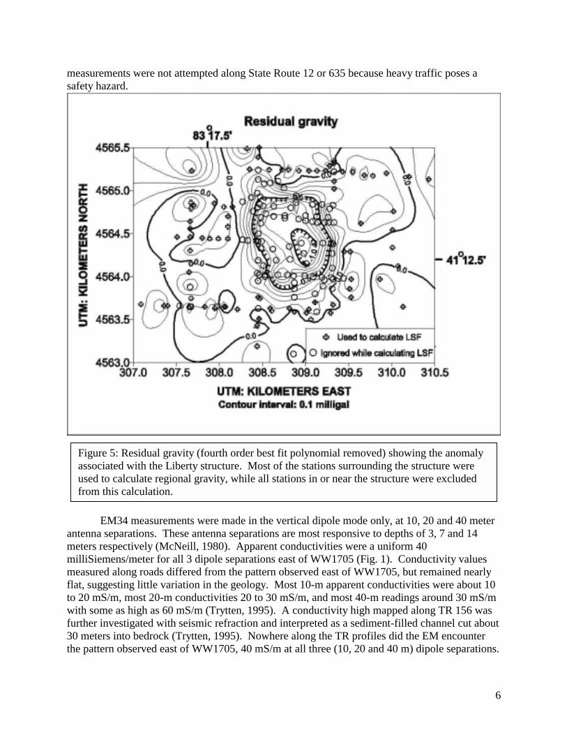
calculatedobservedresidual ggg −= is shown in Fig. 5. The Liberty structure is characterized by a gravity low slightly more than 1 milligal in amplitude and just over 1 km in diameter. This gravity low is oval in shape, slightly elongated north south with respect to the east west, with a steep gradient on the edge and relatively flat center.
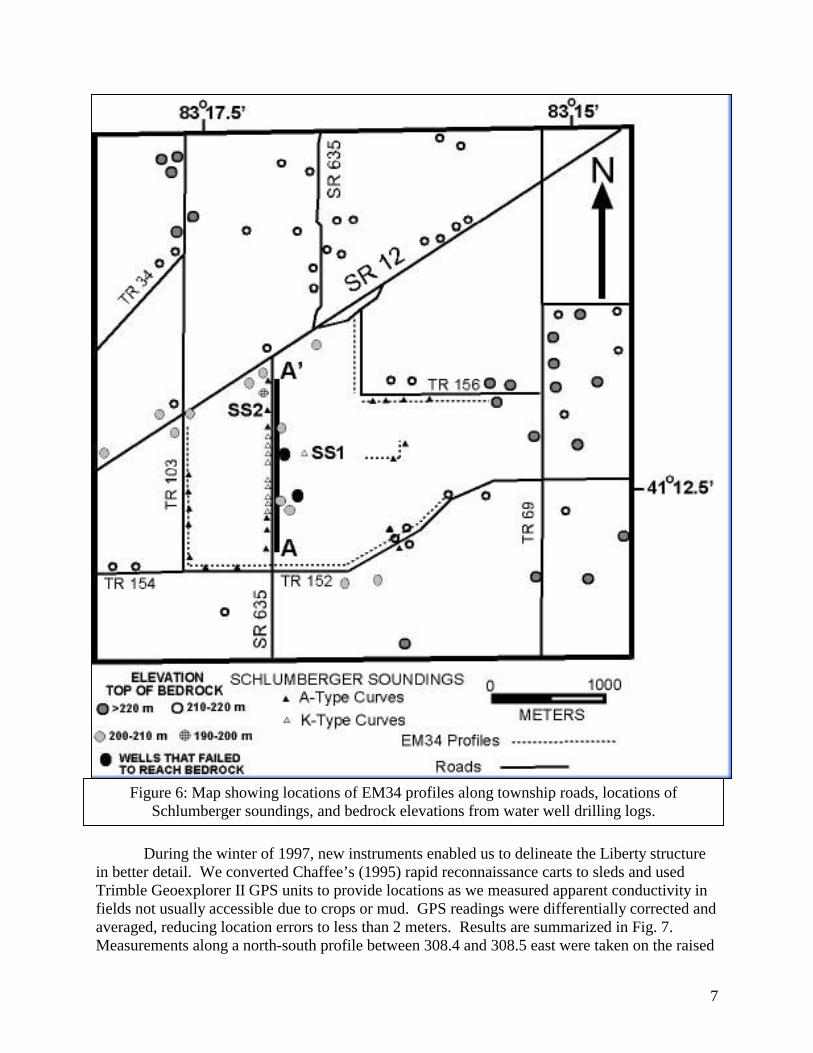
Electromagnetic conductivity: An early hypothesis for the origin of the anomalous geology was that a pre-glacial river valley had incised bedrock (Stout et al., 1943; Cummings, 1959). Because much of the land in the study area is under cultivation, access is often limited to roads and farm lanes for most of the year. A Geonics EM34-L was used to search for bedrock lows along Township Roads 103, 154, 152 and 156 (Fig. 6). Data were collected using a rapid reconnaissance method developed by Chaffee (1995) by placing the EM34 antennas in carts and towing the array, recording measurements with a data logger at regular intervals. EM
Figure 4: Simple Bouguer gravity anomaly in and around the Liberty structure. "+" symbols show locations of gravity stations.
6
measurements were not attempted along State Route 12 or 635 because heavy traffic poses a safety hazard.
EM34 measurements were made in the vertical dipole mode only, at 10, 20 and 40 meter antenna separations. These antenna separations are most responsive to depths of 3, 7 and 14 meters respectively (McNeill, 1980). Apparent conductivities were a uniform 40 milliSiemens/meter for all 3 dipole separations east of WW1705 (Fig. 1). Conductivity values measured along roads differed from the pattern observed east of WW1705, but remained nearly flat, suggesting little variation in the geology. Most 10-m apparent conductivities were about 10 to 20 mS/m, most 20-m conductivities 20 to 30 mS/m, and most 40-m readings around 30 mS/m with some as high as 60 mS/m (Trytten, 1995). A conductivity high mapped along TR 156 was further investigated with seismic refraction and interpreted as a sediment-filled channel cut about 30 meters into bedrock (Trytten, 1995). Nowhere along the TR profiles did the EM encounter the pattern observed east of WW1705, 40 mS/m at all three (10, 20 and 40 m) dipole separations.
Figure 5: Residual gravity (fourth order best fit polynomial removed) showing the anomaly associated with the Liberty structure. Most of the stations surrounding the structure were used to calculate regional gravity, while all stations in or near the structure were excluded from this calculation.
7
During the winter of 1997, new instruments enabled us to delineate the Liberty structure
in better detail. We converted Chaffee’s (1995) rapid reconnaissance carts to sleds and used Trimble Geoexplorer II GPS units to provide locations as we measured apparent conductivity in fields not usually accessible due to crops or mud. GPS readings were differentially corrected and averaged, reducing location errors to less than 2 meters. Results are summarized in Fig. 7. Measurements along a north-south profile between 308.4 and 308.5 east were taken on the raised
Figure 6: Map showing locations of EM34 profiles along township roads, locations of Schlumberger soundings, and bedrock elevations from water well drilling logs.
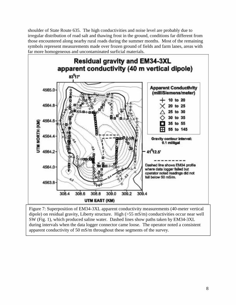
shoulder of State Route 635. The high conductivities and noise level are probably due to irregular distribution of road salt and thawing frost in the ground, conditions far different from those encountered along nearby rural roads during the summer months. Most of the remaining symbols represent measurements made over frozen ground of fields and farm lanes, areas with far more homogeneous and uncontaminated surficial materials.
Figure 7: Superposition of EM34-3XL apparent conductivity measurements (40-meter vertical dipole) on residual gravity, Liberty structure. High (>55 mS/m) conductivities occur near well SW (Fig. 1), which produced saline water. Dashed lines show paths taken by EM34-3XL during intervals when the data logger connector came loose. The operator noted a consistent apparent conductivity of 50 mS/m throughout these segments of the survey.
8
9
Except for stations where high conductivities may be due to shallow effects of de-icing salt along SR 635, most conductivity values over 35 millisiemens/meter (mS/m) lie toward the center of Fig. 7, where residual gravity is lower than -0.6 milligals. Conductivity values less than 25 mS/m surround this central zone of high (> 35 mS/m) apparent conductivity. In several locations the transition from low to high conductivity occurs within a space of 100 meters or less. The transmitter-receiver sleds were generally positioned parallel to the route taken by the field team. Assuming this anomaly is due to a nearly circular structure, about 1 km in diameter, centered near UTM coordinates 4564.4 north, 308.8 east, it appears that measurements in which the instruments were deployed parallel to the radius of such a structure detected a more abrupt change in apparent conductivity than measurements where the instrument array was oriented tangential to and very near the edge. Apparent conductivities of 20 mS/m or less probably indicate shallow carbonate bedrock. The fact that the edge of the residual gravity anomaly extends outside the area where carbonate bedrock has been replaced by basin fill suggests either a deep (> 200 meter) basin, or, that rock adjacent to this basin has been modified so as to lower its bulk density. The highest apparent conductivities (>55 mS/m) are near well SW (Fig. 1) and are probably due to saline water found in that well (Table 2).
Table 2: Summary data on wells drilled along State Route 635, in and near the Liberty Structure. Locations are shown in Fig. 1.
Well Date drilled Bedrock elevation
(m) Hydrology Geology
WW17011 8/87 N.A. (< 179) mud Clay & gravel WW1705 5/90 N.A. (<143) No water Blue clay WW1706 9/98 210 < 1 G.P.M. Limestone, shale
WW2005 10/68 2102 1 G.P.M. Clay, rock, shale3
WW2006 1994 (?) N.A. (<162) 2 G.P.M. Clay, limestone, mud4
SW 3/68 2101 Salt water. Bedrock segment of borehole plugged, water from till-bedrock contact
zone is saline.
Clay, rock, shale3
Artesian Predates records
Not known Productive; good quality ??
1Not shown on map; same location as WW1705. A second shallow (13 m) well (WW1704) was also drilled at this location. Both logs report clay and gravel. 2This is not the Lockport Dolomite expected here. 3Both logs (different drillers) describe "red rock" overlying "gray shale". 4Limestone is interlayered with mud - possibly buried talus? Electrical resistivity: Schlumberger soundings east of WW1705 and north of Wolf Creek (SS1 and SS2 respectively, Fig. 6) detected contrasting subsurface conditions. Shallow bedrock was characterized by type “A” sounding curves (shallow conductors overlying a highly resistive electrical basement; Zohdy et al., 1974, p. 27) in contrast to the K-type sounding curve (slight increase in resistivity followed by decrease) where bedrock is much deeper. Schlumberger soundings were made at 14 locations sampled by the EM34 to verify the reliability of EM as an indicator of depth to top of bedrock in this setting. Soundings were also made in the roadside ditch along State Route 635 (Fig. 6). Results of this profile are displayed in Fig. 8. Eight sounding points, located between UTM 4564.12 and 4564.8, exhibit K-type sounding curves (Zohdy el al., 1974, p. 27), in sharp contrast to the A-type sounding curves for points south of
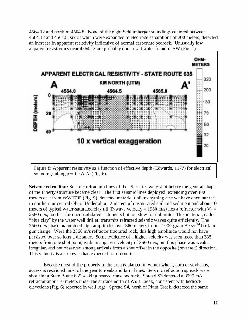
10
4564.12 and north of 4564.8. None of the eight Schlumberger soundings centered between 4564.12 and 4564.8, six of which were expanded to electrode separations of 200 meters, detected an increase in apparent resistivity indicative of normal carbonate bedrock. Unusually low apparent resistivities near 4564.13 are probably due to salt water found in SW (Fig. 1).
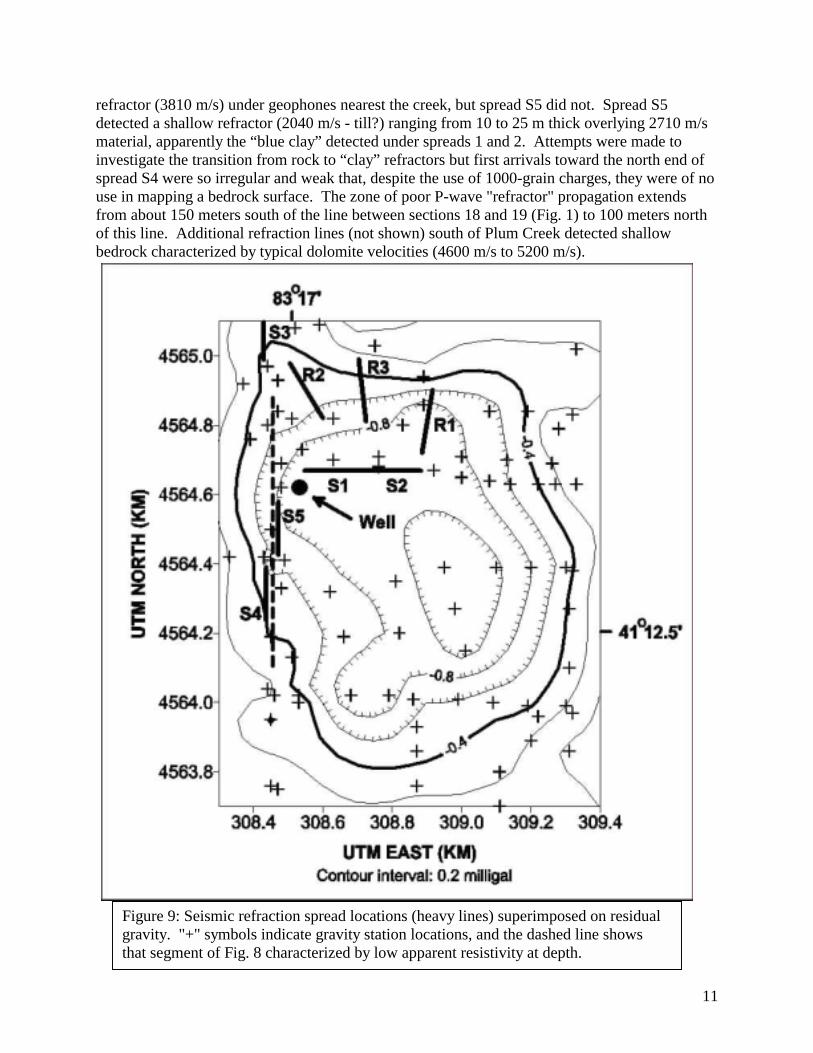
Seismic refraction: Seismic refraction lines of the "S" series were shot before the general shape of the Liberty structure became clear. The first seismic lines deployed, extending over 400 meters east from WW1705 (Fig. 9), detected material unlike anything else we have encountered in northern or central Ohio. Under about 2 meters of unsaturated soil and sediment and about 10 meters of typical water-saturated clay till (P-wave velocity = 1980 m/s) lies a refractor with Vp = 2560 m/s, too fast for unconsolidated sediments but too slow for dolomite. This material, called “blue clay” by the water well driller, transmits refracted seismic waves quite efficiently. The 2560 m/s phase maintained high amplitudes over 360 meters from a 1000-grain BetsyTM buffalo gun charge. Were the 2560 m/s refractor fractured rock, this high amplitude would not have persisted over so long a distance. Some evidence of a higher velocity was seen more than 335 meters from one shot point, with an apparent velocity of 3660 m/s, but this phase was weak, irregular, and not observed among arrivals from a shot offset in the opposite (reversed) direction. This velocity is also lower than expected for dolomite.
Because most of the property in the area is planted in winter wheat, corn or soybeans, access is restricted most of the year to roads and farm lanes. Seismic refraction spreads were shot along State Route 635 seeking near-surface bedrock. Spread S3 detected a 3990 m/s refractor about 10 meters under the surface north of Wolf Creek, consistent with bedrock elevations (Fig. 6) reported in well logs. Spread S4, north of Plum Creek, detected the same
Figure 8: Apparent resistivity as a function of effective depth (Edwards, 1977) for electrical soundings along profile A-A' (Fig. 6).
11
refractor (3810 m/s) under geophones nearest the creek, but spread S5 did not. Spread S5 detected a shallow refractor (2040 m/s - till?) ranging from 10 to 25 m thick overlying 2710 m/s material, apparently the “blue clay” detected under spreads 1 and 2. Attempts were made to investigate the transition from rock to “clay” refractors but first arrivals toward the north end of spread S4 were so irregular and weak that, despite the use of 1000-grain charges, they were of no use in mapping a bedrock surface. The zone of poor P-wave "refractor" propagation extends from about 150 meters south of the line between sections 18 and 19 (Fig. 1) to 100 meters north of this line. Additional refraction lines (not shown) south of Plum Creek detected shallow bedrock characterized by typical dolomite velocities (4600 m/s to 5200 m/s).
Figure 9: Seismic refraction spread locations (heavy lines) superimposed on residual gravity. "+" symbols indicate gravity station locations, and the dashed line shows that segment of Fig. 8 characterized by low apparent resistivity at depth.
12
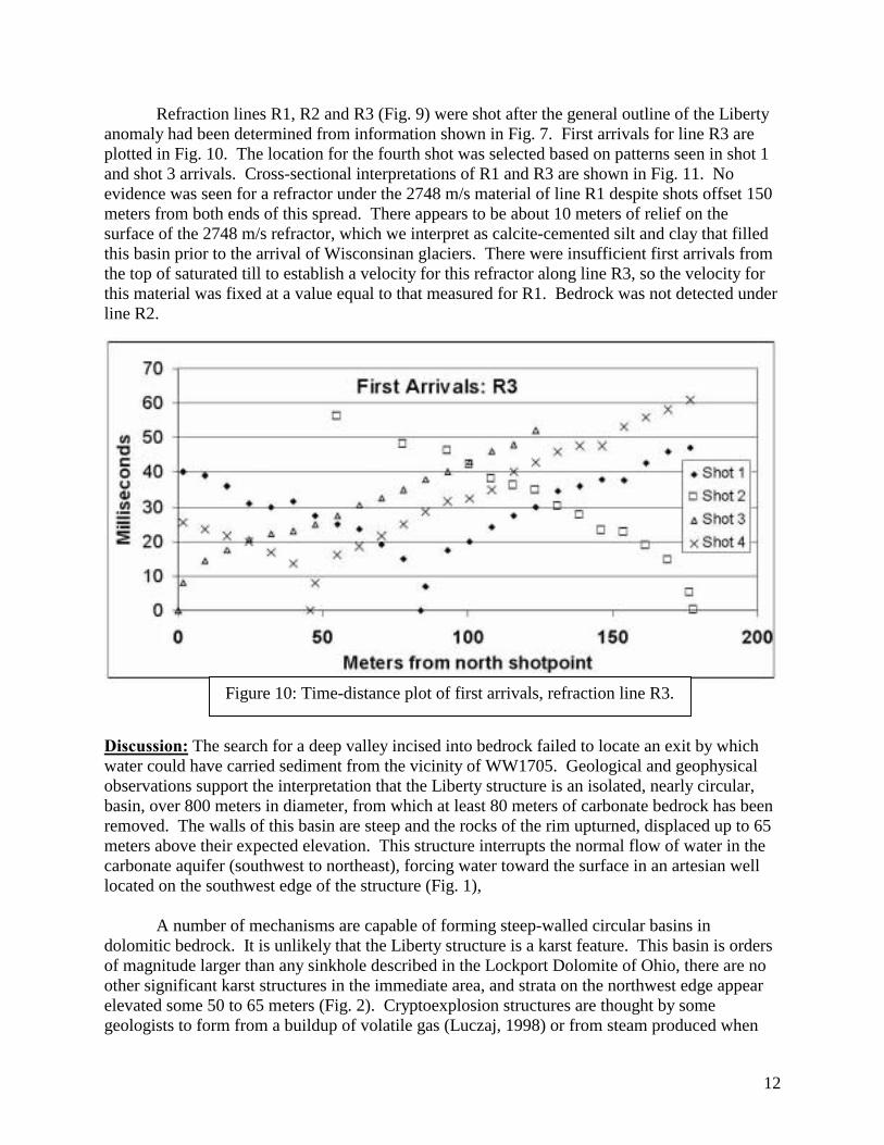
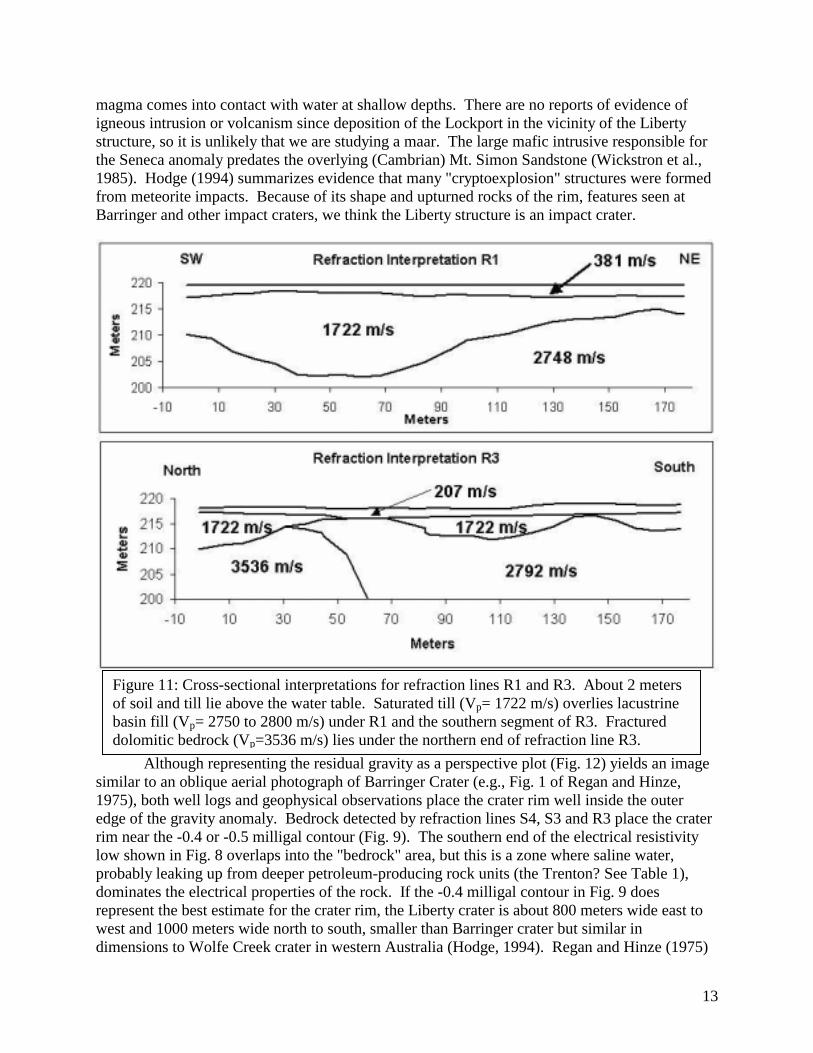
Refraction lines R1, R2 and R3 (Fig. 9) were shot after the general outline of the Liberty anomaly had been determined from information shown in Fig. 7. First arrivals for line R3 are plotted in Fig. 10. The location for the fourth shot was selected based on patterns seen in shot 1 and shot 3 arrivals. Cross-sectional interpretations of R1 and R3 are shown in Fig. 11. No evidence was seen for a refractor under the 2748 m/s material of line R1 despite shots offset 150 meters from both ends of this spread. There appears to be about 10 meters of relief on the surface of the 2748 m/s refractor, which we interpret as calcite-cemented silt and clay that filled this basin prior to the arrival of Wisconsinan glaciers. There were insufficient first arrivals from the top of saturated till to establish a velocity for this refractor along line R3, so the velocity for this material was fixed at a value equal to that measured for R1. Bedrock was not detected under line R2.
Discussion: The search for a deep valley incised into bedrock failed to locate an exit by which water could have carried sediment from the vicinity of WW1705. Geological and geophysical observations support the interpretation that the Liberty structure is an isolated, nearly circular, basin, over 800 meters in diameter, from which at least 80 meters of carbonate bedrock has been removed. The walls of this basin are steep and the rocks of the rim upturned, displaced up to 65 meters above their expected elevation. This structure interrupts the normal flow of water in the carbonate aquifer (southwest to northeast), forcing water toward the surface in an artesian well located on the southwest edge of the structure (Fig. 1),
A number of mechanisms are capable of forming steep-walled circular basins in dolomitic bedrock. It is unlikely that the Liberty structure is a karst feature. This basin is orders of magnitude larger than any sinkhole described in the Lockport Dolomite of Ohio, there are no other significant karst structures in the immediate area, and strata on the northwest edge appear elevated some 50 to 65 meters (Fig. 2). Cryptoexplosion structures are thought by some geologists to form from a buildup of volatile gas (Luczaj, 1998) or from steam produced when
Figure 10: Time-distance plot of first arrivals, refraction line R3.
13
magma comes into contact with water at shallow depths. There are no reports of evidence of igneous intrusion or volcanism since deposition of the Lockport in the vicinity of the Liberty structure, so it is unlikely that we are studying a maar. The large mafic intrusive responsible for the Seneca anomaly predates the overlying (Cambrian) Mt. Simon Sandstone (Wickstron et al., 1985). Hodge (1994) summarizes evidence that many "cryptoexplosion" structures were formed from meteorite impacts. Because of its shape and upturned rocks of the rim, features seen at Barringer and other impact craters, we think the Liberty structure is an impact crater.
Although representing the residual gravity as a perspective plot (Fig. 12) yields an image similar to an oblique aerial photograph of Barringer Crater (e.g., Fig. 1 of Regan and Hinze, 1975), both well logs and geophysical observations place the crater rim well inside the outer edge of the gravity anomaly. Bedrock detected by refraction lines S4, S3 and R3 place the crater rim near the -0.4 or -0.5 milligal contour (Fig. 9). The southern end of the electrical resistivity low shown in Fig. 8 overlaps into the "bedrock" area, but this is a zone where saline water, probably leaking up from deeper petroleum-producing rock units (the Trenton? See Table 1), dominates the electrical properties of the rock. If the -0.4 milligal contour in Fig. 9 does represent the best estimate for the crater rim, the Liberty crater is about 800 meters wide east to west and 1000 meters wide north to south, smaller than Barringer crater but similar in dimensions to Wolfe Creek crater in western Australia (Hodge, 1994). Regan and Hinze (1975)
Figure 11: Cross-sectional interpretations for refraction lines R1 and R3. About 2 meters of soil and till lie above the water table. Saturated till (Vp= 1722 m/s) overlies lacustrine basin fill (Vp= 2750 to 2800 m/s) under R1 and the southern segment of R3. Fractured dolomitic bedrock (Vp=3536 m/s) lies under the northern end of refraction line R3.
14
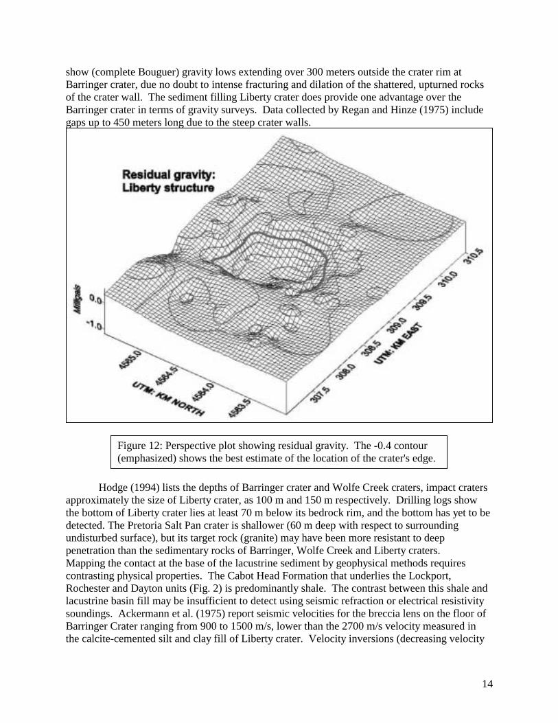
show (complete Bouguer) gravity lows extending over 300 meters outside the crater rim at Barringer crater, due no doubt to intense fracturing and dilation of the shattered, upturned rocks of the crater wall. The sediment filling Liberty crater does provide one advantage over the Barringer crater in terms of gravity surveys. Data collected by Regan and Hinze (1975) include gaps up to 450 meters long due to the steep crater walls.
Hodge (1994) lists the depths of Barringer crater and Wolfe Creek craters, impact craters approximately the size of Liberty crater, as 100 m and 150 m respectively. Drilling logs show the bottom of Liberty crater lies at least 70 m below its bedrock rim, and the bottom has yet to be detected. The Pretoria Salt Pan crater is shallower (60 m deep with respect to surrounding undisturbed surface), but its target rock (granite) may have been more resistant to deep penetration than the sedimentary rocks of Barringer, Wolfe Creek and Liberty craters. Mapping the contact at the base of the lacustrine sediment by geophysical methods requires contrasting physical properties. The Cabot Head Formation that underlies the Lockport, Rochester and Dayton units (Fig. 2) is predominantly shale. The contrast between this shale and lacustrine basin fill may be insufficient to detect using seismic refraction or electrical resistivity soundings. Ackermann et al. (1975) report seismic velocities for the breccia lens on the floor of Barringer Crater ranging from 900 to 1500 m/s, lower than the 2700 m/s velocity measured in the calcite-cemented silt and clay fill of Liberty crater. Velocity inversions (decreasing velocity
Figure 12: Perspective plot showing residual gravity. The -0.4 contour (emphasized) shows the best estimate of the location of the crater's edge.
15
with depth) cannot be detected by traditional refraction methods. Seismic reflection or deep time-domain electromagnetic soundings might prove helpful in mapping what lies hidden 100 to 500 meters under the present surface at Liberty crater.
Although uncertainties regarding density contrasts are too numerous to permit developing well-constrained structural models, attenuating the influence of the Seneca anomaly permits some attempts at quantitative analysis of this gravity low. An anomalous mass of -1.56 x 10¹⁰ kg was calculated using a technique based on Gauss' Law (Grant and West, 1965, pp. 269-273). Details are shown in Appendix B. This infers that 2 x 10¹¹ kg (73 million cubic meters) of Lockport Dolomite (assumed density = 2750 kg-m-3) has been replaced with 2550 kg-m-3 cemented lacustrine sediments. A vertical cylinder 75 to 83 meters thick and 800 to 1000 meters in diameter contains between 38 and 65 million cubic meters. The balance of the missing dolomite was eroded from the upthrown rim. Uncertainties regarding densities, however, limit our ability to develop a well-constrained model. If a breccia lens underlies the Liberty crater, this breccia probably contains carbonate clasts and may be denser than the shale it replaces (Fig. 13a), unlike the breccia lens under Barringer crater, which is less dense than the country rock.. Core samples from within and adjacent to the crater are needed to provide density information needed to constrain models based on gravity, as they were used by Regan and Hinze (1975).
Additional geophysical studies of Liberty crater include plans to reoccupy selected
gravity stations near the structure and fill gaps both in and near the structure. Over the past 7 years, six different people using 4 different gravity meters have compiled a data set of varying quality. We hope that use of a new model “G” meter with internal electronic level indicators will reduce the noise apparent in Fig. 6. We also plan additional electrical resistivity and seismic refraction, with profiles oriented along crater radii, when fields are accessible. We have discussed other methods (ground-penetrating radar and seismic reflection) with scientists who have the appropriate experience and instruments. But the true nature of the Liberty crater will remain uncertain until it is drilled and the core studied.
Direct and compelling evidence that the Liberty crater was formed from an impact has
not been recognized. The target rocks are carbonates and shale, so shocked quartz is not likely to be found in cuttings from WW1706. A borehole drilled to a depth of 400 meters inside the -0.8 milligal contour (Fig. 9) should, if this is an impact crater, penetrate 80 to 150 meters of lacustrine basin fill and 150 to 200 meters of fallback breccia. If the Liberty crater resulted from an impact, we will find shatter cone structures in large breccia clasts (Carlton et al., 1998) and in the Trenton Formation (Fig. 13). Samples of fallback breccia matrix will be tested for high iridium content.
The severe deformation associated with the Liberty crater, be it due to impact or
explosive gas, raises an issue that should be of concern to those responsible for monitoring deep liquid waste injection wells. There is no way, based on analysis of regional structural relationships and stratigraphy, to predict where these craters and zones of shattered rock might be located. Wells drilled just a few hundred meters from the rim of such craters might fail to provide clues to their presence. If the saline water found in well SW (Fig. 1 and Table 2) originated in rocks that normally lie hundreds of meters under the surface, rocks that would otherwise isolate fluids at depth from shallow aquifers have been breached. Currently, the
16
United States Environmental Protection Agency (USEPA) does not require operators of deep hazardous waste injection wells to provide evidence that the area immediately surrounding their facilities is devoid of either impact craters or cryptoexplosion structures. The USEPA does not require permit applicants to document the integrity of rock formations separating the injection horizon from aquifers, applying instead the standard that lack of evidence regarding faults or other fluid conduits provides sufficient protection. Seismic reflection profiles such as those used in petroleum exploration would be sufficient to provide this documentation and should be, but are not, required as part of permit applications.
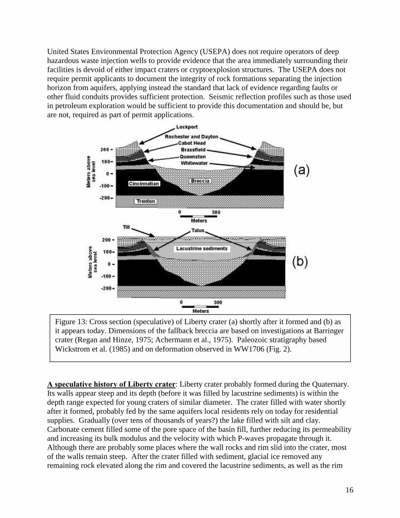
A speculative history of Liberty crater: Liberty crater probably formed during the Quaternary. Its walls appear steep and its depth (before it was filled by lacustrine sediments) is within the depth range expected for young craters of similar diameter. The crater filled with water shortly after it formed, probably fed by the same aquifers local residents rely on today for residential supplies. Gradually (over tens of thousands of years?) the lake filled with silt and clay. Carbonate cement filled some of the pore space of the basin fill, further reducing its permeability and increasing its bulk modulus and the velocity with which P-waves propagate through it. Although there are probably some places where the wall rocks and rim slid into the crater, most of the walls remain steep. After the crater filled with sediment, glacial ice removed any remaining rock elevated along the rim and covered the lacustrine sediments, as well as the rim
Figure 13: Cross section (speculative) of Liberty crater (a) shortly after it formed and (b) as it appears today. Dimensions of the fallback breccia are based on investigations at Barringer crater (Regan and Hinze, 1975; Achermann et al., 1975). Paleozoic stratigraphy based Wickstrom et al. (1985) and on deformation observed in WW1706 (Fig. 2).
17
and surrounding bedrock, with till (Fig. 13b). Although the origin of the crater can range from post-Silurian to pre-Wisconsinan, the fact that the crater has not been deeply eroded and appears well preserved suggests that it is probably young. It is likely that, while it was a lake, Liberty crater attracted fauna seeking water. The steep walls of broken rock probably failed to provide secure footing at times. It is likely that animals perished along the shores of this lake and that some fossilized remains lie preserved in the lacustrine sediments. Lacustrine sediments of Liberty crater may preserve a paleontological and climatic record unique in the eastern United States. A note on selecting a name: In holding with the tradition that geological features take their names from existing geographical labels, several potential names for the Liberty structure were considered and rejected. The structure lies just south of Wolf Creek (Fig. 1), but this might lead to confusion with a crater in Australia with a similar name. The structure lies in Seneca County, which lent its name to the Seneca anomaly (Lucius and Von Frese, 1988), another potential source of confusion. The structure lies under land owned by at least six different parties, none of whose names appear on the topographic map. Our choice is based on the proximity of this crater to Liberty Cemetery and Liberty Chapel, in Liberty Township. Conclusions: A circular basin at least 80 meters deep and 800 meters in diameter exists in the Paleozoic Lockport Dolomite in Liberty Township of Seneca County, Ohio. This basin, filled with carbonate-cemented sediments, lies concealed by till. A meteor impact prior to the onset of Wisconsin age glaciation was probably responsible for this crater. Lacustrine sediments filling this crater probably record climatic information and fossil remains from a prehistoric ecosystem unique to the known geology of eastern North America. Acknowledgements: We are grateful to land owners and tenants who allow us to work on their properties. We thank geophysicists of Wright State University, Bowling Green State University and Western Michigan University for loaning us gravity meters, and Geonics, Ltd. for the loan of an EM34 with data logger. We acknowledge the aid of many University of Toledo student volunteers who assisted with the fieldwork. The electronic total station and GPS receivers were purchased with funds provided by The National Science Foundation. Informal reviews by Robert W. Simpson and Craig Hatfield resulted in substantial improvements to the manuscript. Field work was supported by Departmental funds of the Geology Department, College of Arts & Sciences, of The University of Toledo. Please note: Reviewers found the evidence presented here unconvincing. There is no physical evidence presented that the Liberty structure was caused by an impact, and a geophysical study of a mysterious hole in the bedrock is unlikely to excite readers. Update links will be posted at http://www.eeescience.utoledo.edu/Faculty/Stierman/RES/LibC/ix.htm.
18
References Achermann H.D., Godson R.H. and Watkins J.S. (1975) A seismic refraction technique used for subsurface investigations at Meteor Crater, Arizona. J. Geophys. Res., 80, 765-775. Bolsenga S.J. and Hendendorf C.E. (Eds.) (1993) Lake Erie and Lake St. Clair Handbook; Wayne State University Press, Detroit, Michigan, USA. 467 pp. Carlton R.W., Koeberl C. and Schumacher G.A. (1998) Discovery of planar deformation features in the Serpent Mound disturbance, south-central Ohio: unequivocal evidence for an impact (abstract). GSA Abstracts with Program, 30 (2), 8. Chaffee M.C. (1995) Geophysical prospecting for karst features in the Bellevue-Castalia region of northwest Ohio. M.S. thesis, Geology Department, The University of Toledo, Toledo, USA. 128 pp. Cummings J.W. (1959) Buried river valleys in Ohio. Ohio Water Plan Inventory Report No. 10. Ohio Division of Water, Columbus, Ohio, USA. 2 maps, 3 pp. Edwards L.S. (1977) A modified pseudosection for resistivity and I.P. Geophysics, 42, 1020-1036. Grant F.S. and West G.F. (1965) Interpretation Theory in Applied Geophysics. McGraw-Hill, San Francisco, USA. 584 pp. Hodge P. (1994) Meteorite craters and impact structures of the Earth. Cambridge University Press, Cambridge, Great Britain. 124 pp. Luczaj J. (1998) Argument supporting explosive igneous activity for the origin of "cryptoexplosion" structures in the midcontinent, United States; Geology, 26, 295-298. McNeill J.D. (1980) Electromagnetic terrain conductivity measurement at low induction numbers. Technical Note TN-6. Geonics Ltd., Mississauga, Canada. 15 pp. Norris S.E. and Fidler R.E. (1971) Availability of ground water from limestone and dolomite aquifers in northwest Ohio and its relation to structure. U.S.G.S. Professional Paper 750-B, pp. B229-B235. Regan, R.D. and Hinze W.J. (1975) Gravity and magnetic investigations of Meteor Crater, Arizona. J. Geophys. Res., 80, 776-788. Stout,W., Ver Steeg K. and Lamb G.F. (1943) Geology of water in Ohio. Ohio Geological Survey Bull. 44, 693 pp. Trytten B.B. (1995) Preliminary geophysical investigation of a buried bedrock basin, Liberty Township, Seneca County, Ohio. M.S. thesis, Geology Department, The University of Toledo, Toledo, Ohio USA. 253 pp.
19
Wickstrom L.H., Botoman G. and Stith D.A. (1985) Report on a continuously cored hole drilled into the Precambrian in Seneca County, northwestern Ohio. Information Circular No. 51. Ohio Department of Natural Resources, Division of Geological Survey, Columbus, Ohio, USA. 1 sheet. Zohdy A.A.R., Eaton G.P. and Mabey D.R. (1974) Application of surface geophysics to ground-water investigations. In Techniques of Water-Resources Investigations of the United States Geological Survey, Chapter D-1, 116 pp.
20
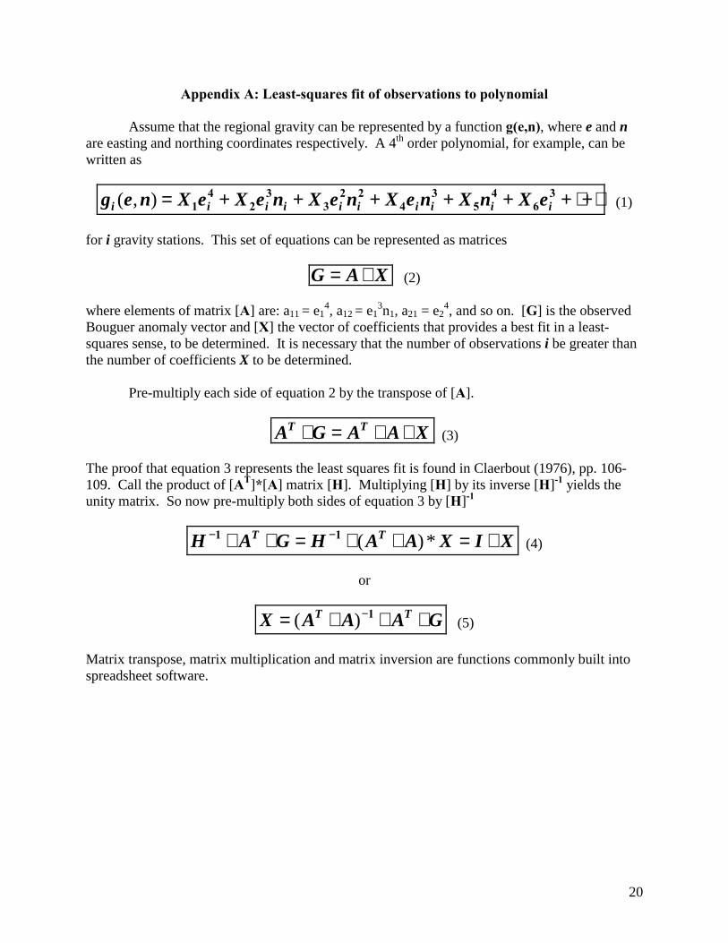
Appendix A: Least-squares fit of observations to polynomial
Assume that the regional gravity can be represented by a function g(e,n), where e and n are easting and northing coordinates respectively. A 4th order polynomial, for example, can be written as
⋅+⋅++++++= 36
45
34
223
32
41 iiiiiiiiii eXnXneXneXneXeXneg ),( (1)
for i gravity stations. This set of equations can be represented as matrices
XAG ∗= (2)
where elements of matrix [A] are: a11 = e14, a12 = e1
3n1, a21 = e24, and so on. [G] is the observed
Bouguer anomaly vector and [X] the vector of coefficients that provides a best fit in a least-squares sense, to be determined. It is necessary that the number of observations i be greater than the number of coefficients X to be determined. Pre-multiply each side of equation 2 by the transpose of [A].
XAAGA TT ∗∗=∗ (3)
The proof that equation 3 represents the least squares fit is found in Claerbout (1976), pp. 106-109. Call the product of [AT]*[A] matrix [H]. Multiplying [H] by its inverse [H]-1 yields the unity matrix. So now pre-multiply both sides of equation 3 by [H]-1
XIXAAHGAH TT ∗=∗∗=∗∗ −− *)(11 (4)
or
GAAAX TT ∗∗∗= −1)( (5)
Matrix transpose, matrix multiplication and matrix inversion are functions commonly built into spreadsheet software.
21
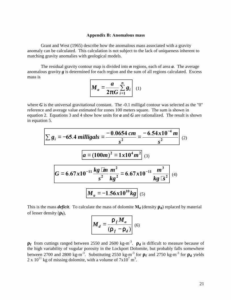
Appendix B: Anomalous mass
Grant and West (1965) describe how the anomalous mass associated with a gravity anomaly can be calculated. This calculation is not subject to the lack of uniqueness inherent to matching gravity anomalies with geological models. The residual gravity contour map is divided into n regions, each of area a. The average anomalous gravity g is determined for each region and the sum of all regions calculated. Excess mass is
�=
=n
iia g
GaM
12ππππ (1)
where G is the universal gravitational constant. The -0.1 milligal contour was selected as the "0" reference and average value estimated for zones 100 meters square. The sum is shown in equation 2. Equations 3 and 4 show how units for a and G are rationalized. The result is shown in equation 5.
2
4
21054606540465
smx
scmmilligalsgi
−−=−=−=�... (2)
242 101100 mxma == )( (3)
2
311
2
2
211 1067610676
skgmx
kgm
smkgxG
⋅=⋅= −− .. (4)
kgxMa1010561.−= (5)
This is the mass deficit. To calculate the mass of dolomite Md (density ρd) replaced by material of lesser density (ρf),
)( df
afd
MM
ρρρρρρρρρρρρ
−= (6)
ρf from cuttings ranged between 2550 and 2600 kg-m-3. ρd is difficult to measure because of the high variability of vugular porosity in the Lockport Dolomite, but probably falls somewhere between 2700 and 2800 kg-m-3. Substituting 2550 kg-m-3 for ρf and 2750 kg-m-3 for ρd yields 2 x 10¹¹ kg of missing dolomite, with a volume of 7x10⁷ m3.

22
If the missing dolomite can be approximated by a vertical cylinder, with thickness h = 75 to 83 meters (Table 1) and radius r = 400 to 500 meters (Fig. 9), the range of volume is
37237 10561083 mxhrmx .. << ππππ (7).