Embed Size (px)
Citation preview

1
GEOPHYSICAL SURVEY FOR WATER PERSPECTIVES IN
AN ARID PASTORAL-AGROPASTORAL CONTEXT: ZONE 1 AFAR REGION IN ETHIOPIA.
-
December 2005
-
Dr. Ignacio Marzan
1. Introduction .............................................................................................................. 2
2. Background............................................................................................................... 2
3. Campaign.................................................................................................................. 3
4. gurmudele area ......................................................................................................... 4
4.1 Problematic....................................................................................................... 4
4.2 Survey............................................................................................................... 5
5. Basaltic floor area..................................................................................................... 7
5.1 Introduction ...................................................................................................... 7
5.2 Survey phase A................................................................................................. 8
5.3 Survey phase B ............................................................................................... 11
Wahalimat............................................................................................................... 11
Serdo....................................................................................................................... 12
Guyah ..................................................................................................................... 12
Gulubele ................................................................................................................. 14
6. Detbahari area......................................................................................................... 15
6.1 Introduction .................................................................................................... 15
6.2 Survey phase A............................................................................................... 17
6.3 Survey phase B ............................................................................................... 21
Gera ........................................................................................................................ 21
Mahie Cambo ......................................................................................................... 21
Aser Andegna ......................................................................................................... 22
Ibourrimego ............................................................................................................ 23
Lagifage.................................................................................................................. 24
Arado ...................................................................................................................... 24
Soudan Camp.......................................................................................................... 25
Huletegna / Lagi Goho ........................................................................................... 25
Califage................................................................................................................... 26
7. Reference ................................................................................................................ 27
8. Annex ..................................................................................................................... 27

2
1. Introduction
This work reports the geophysical survey conducted in Zone 1 of, the Afar region in May-June 2005 by ACF in collaboration with the Regional Water Bureau. This geophysical study aims to solve problems finding fresh groundwater for the present water program of ACF in the area.
In 2004 ACF assessment, 23 sites were proposed for groundwater exploitation in Zone 1 of Afar region (Analysis for water perspectives in an arid pastoral-agropastoral context: Afar region in Ethiopia). The first 8th boreholes drilled by ACF in 2004-2005 turned out to be negative (dry or too saline). In consequence ACF decided to implement a geophysical survey aiming to reduce failure risks.
Finding fresh groundwater in Afar region is extremely difficult and the success-failure balance uses to be negative for all the water actors intervening in the region. The present survey aimed to improve the ACF balance and to improve also hydrogeological knowledge of the region.
We will not explain in to much detail the social and environmental context. The justification and impact for new water points are already the subject of ACF 2004 and ACF 2003 reports. This is a purely technical report about water possibilities for sites already identified by ACF in 2004.
In the annex we attach a table compiling basic information about every village where we suggest working.
2. Background
The Afar Region is a characteristically dry region in North East Ethiopia at the head of the Rift Valley. The region spreads from hilly escarpments at the foot of the Ethiopian highlands in the west, to deserted basins surrounded by volcanic lava flows in the east. Active volcanism and geothermal phenomena are an expression of the ongoing rifting process.
The altitude ranges from 1500 metres in the west to over 100 meters below sea level in the east (Danakil depression), with an area of about 120,000 km², a human population of around one million and with 92.2% living in the rural areas. Administratively, the Afar Region is divided into 5 Zones and 29 Woredas.
The surveying sites are all in the Zone 1 of the Afar Region. We worked in three main contexts (Fig. 1):
-In the Awash riverbank, in Gurmudele village.
-Inside de Awash internal delta, around Detbahari cotton plantation.
-In the Basaltic Floor area.
The study was conducted in two main geological units:
-Basaltic floor. This unit is deeply fractured and highly permeable. The rugged characteristics of landscape cause short and strong runoffs that canalise large amounts of water from the occasional rains. In these conditions, streams are unable to organise a fluvial system. Shallow to medium fresh aquifers are isolated into stream bank deposits. Extensive aquifers are very deep and with moderate to bad water quality (chemically altered by geothermal processes).
-Awash River sedimentary basin. It is filled with fine to very fine sediments, with low permeability. The alluvial aquifers are available at shallow depths with moderate to low productivity and low water quality.

3
33333333
33333333
33333333
33333333
33333333
33333333
33333333
33333333
)
)
)
)
)
)
)
)
)
)
)
)
)
)
))
)
)
))
)
)
)
)
)
)
)
)
Gurmudele
area
Detbaharie
area
Basaltic floor
area
Kilomètres
0 10 20
N
Extensive and Extensive and Extensive and Extensive and Extensive and Extensive and Extensive and Extensive and Extensive and
traditional culturestraditional culturestraditional culturestraditional culturestraditional culturestraditional culturestraditional culturestraditional culturestraditional culturesCottonCottonCottonCottonCottonCottonCottonCottonCotton
CottonCottonCottonCottonCottonCottonCottonCottonCotton
DUBTIDUBTIDUBTIDUBTIDUBTIDUBTIDUBTIDUBTIDUBTIDUBTIDUBTIDUBTIDUBTIDUBTIDUBTIDUBTIDUBTIDUBTIDUBTIDUBTIDUBTIDUBTIDUBTIDUBTIDUBTIDUBTIDUBTIDUBTIDUBTIDUBTIDUBTIDUBTIDUBTIDUBTIDUBTIDUBTIDUBTIDUBTIDUBTIDUBTIDUBTIDUBTIDUBTIDUBTIDUBTIDUBTIDUBTIDUBTIDUBTI
AYSSAITAAYSSAITAAYSSAITAAYSSAITAAYSSAITAAYSSAITAAYSSAITAAYSSAITAAYSSAITAAYSSAITAAYSSAITAAYSSAITAAYSSAITAAYSSAITAAYSSAITAAYSSAITAAYSSAITAAYSSAITAAYSSAITAAYSSAITAAYSSAITAAYSSAITAAYSSAITAAYSSAITAAYSSAITAAYSSAITAAYSSAITAAYSSAITAAYSSAITAAYSSAITAAYSSAITAAYSSAITAAYSSAITAAYSSAITAAYSSAITAAYSSAITAAYSSAITAAYSSAITAAYSSAITAAYSSAITAAYSSAITAAYSSAITAAYSSAITAAYSSAITAAYSSAITAAYSSAITAAYSSAITAAYSSAITAAYSSAITA
ELI DEHARELI DEHARELI DEHARELI DEHARELI DEHARELI DEHARELI DEHARELI DEHARELI DEHARELI DEHARELI DEHARELI DEHARELI DEHARELI DEHARELI DEHARELI DEHARELI DEHARELI DEHARELI DEHARELI DEHARELI DEHARELI DEHARELI DEHARELI DEHARELI DEHARELI DEHARELI DEHARELI DEHARELI DEHARELI DEHARELI DEHARELI DEHARELI DEHARELI DEHARELI DEHARELI DEHARELI DEHARELI DEHARELI DEHARELI DEHARELI DEHARELI DEHARELI DEHARELI DEHARELI DEHARELI DEHARELI DEHARELI DEHARELI DEHAR
samara
Alito
Gulubelei
Guyah
Sodonta
Serdo
Wahalimat
paradisio
Leado
Dobi
dichoto
Galaf i
Similaita
Mego
Calif ague
Aysaïta
Forman
DubtiLogia
Galaha
Boreholes
drysaltynot w orkingw orkingstatus unknow n
33333333
)
Main pasture zonesMain pasture zonesMain pasture zonesMain pasture zonesMain pasture zonesMain pasture zonesMain pasture zonesMain pasture zonesMain pasture zones
Main Culture AreasMain Culture AreasMain Culture AreasMain Culture AreasMain Culture AreasMain Culture AreasMain Culture AreasMain Culture AreasMain Culture Areas
ZONEZONE
WOREDAWOREDAWOREDAWOREDAWOREDAWOREDAWOREDAWOREDAWOREDAWOREDAWOREDAWOREDAWOREDAWOREDAWOREDAWOREDAWOREDAWOREDAWOREDAWOREDAWOREDAWOREDAWOREDAWOREDAWOREDAWOREDAWOREDAWOREDAWOREDAWOREDAWOREDAWOREDAWOREDAWOREDAWOREDAWOREDAWOREDAWOREDAWOREDAWOREDAWOREDAWOREDAWOREDAWOREDAWOREDAWOREDAWOREDAWOREDAWOREDA
Road
PondPond
Tow n
Fig. 1 Working areas in Zon1 Afar Region
3. Campaign
Implementation
The geophysical survey in Zone 1 of Afar Region was implemented from May to July 2004. In this period we conducted 53 surveys for a total of 16 sites, using a 72 electrodes Syscal resistivitymetre made by Iris Instruments.
We use Electre II v04.02.00 software to create the sequences and Prosys v09.05.00 software to download data, both of them by Iris Instrument.
We used generally 5 m spacing between electrodes. In some cases, looking for more precision, we reduced to 3 or 2m spacing.
We had chosen two types of geometries, Wenner-alpha and Pole-Pole arrays, depending on the depth and area to cover. Now, we realise that Wenner-Schlumberger array could be also useful due to the laminar structure of the geology in some contexts.
As it is usual in geophysics, a lot of problems appear during the implementation process; but a main problem to bring out was damage on the resistivitymetre which disabled the last measuring channels. As a consequence, during most of the campaign we only worked with 54 electrodes.

4
Calibration
Geophysics is usually the last tool to implement in a prospecting process. Geophysics will be used to confirm and to precise hypothesis coming from surface methods (geology, mappings, aerial photo, sat-image, water point database extrapolation…).
The uncertainty to associate resistivity values to geological formations is a constraint inherent to geophysical methods. This is a main source of errors for interpreting the final models. To reduce uncertainty, the geophysical method needs to be calibrated in every new context.
For calibrating the resistivitymetre, it is necessary a deep geological-hydrogeological knowledge of the context. Also, it is essential measuring location where a lithological description is available, ideally a borehole; hence, it is possible to correlate resistivities for any geological unity, and synthetic with real depths.
Working in isolated areas, data availability is often poor, hence the correlation is ambiguous and interpretation questionable. This is a main problem in the Basaltic Floor area surveyed. To partially solve the problem, we conducted surveys in geological outcrops to correlate resistivities.
Interpretation
For interpreting we used a 2D inverse method by means of Res2dinv 3.5 software (Geotomo Software + Dr. Loke tutorial) producing a set of resistivity models.
The entire exposed models are inverted using a robust constraint method. This method will enhance sharp limits, salinity borders, fractures or isolated reservoirs.
For simplicity we use a contouring with a standard colour scale (from 5 to 10000 Ωm) for all the graphics, excepted in Detbahari case where we reduce in one order the scale values (from 0,5 to 1000 Ωm).
In the cases where we propose possible values/colours for an aquifer, it is only valid for the same context.
Accuracy of proposed depth values entails uncertainties up to ±10 m for big depths. So, all depth values proposed in this study must be considered as an approximation.
4. gurmudele area
4.1 Problematic
Gurmudele is a small village 4 km far from ACF base in Logia. Because of its proximity and because of ACF had started to dig a well there, we chosen this place for training the geophysics team. Unexpectedly, the training survey revealed no trace of water in the ACF well location. We stopped digging the well and we added this location to the campaign planning.
In Gurmudele there are no permanent water points. The village (Fig. 2) is located in the Awash riverbank, in the external part of an abandoned river bend. The river suddenly diverts 5 years ago and now the Gurmudele riverbed is dry except during occasional overflows.
At first, we thought it would be easy to find groundwater in the Gurmudele area. Although the Awash River basin is dominated by fine sediments with low porosity, we expected to find a wealth of thicker sediments (high porosity) close to the riverbank. Fed by alluvial aquifer, the thick deposits will be saturated of water at shallow levels. Sadly, the geophysical results show large clay formation and few thick deposits, mainly located under the riverbed.

5
N
0 0.25 0.5
Kilomètres
Dry river bedDry river bed
Route to Dubti
Gurmudule
Line4
Line5
Line7
Line1
Line2
Line9
Line3
Line 12
Fig. 2. Gurmudele area. Red arrows show length and direction of the more reliable
geoelectrical surveys
4.2 Survey
The Line 2 was conducted where ACF well was being dug. From the inverse resistivity model (Fig. 3) we deduce:
-The well is in a low resistivity formation (pink colours). We interpret it as a massive clay formation, so low porosity, so aquiclude.
-The internal riverbank of the river bend shows higher resistivity values (blue colours). We interpret it as thicker deposits (provably sand and gravel) with high porosity, in consequence good aquifers
We proposed to the community a new well location in the internal side of the river bend. However, the community argued that well access will be limited during weeks after every overflow because of muddy nature of the riverbed. Hence, we search for a better location around the village. Finally we conducted 12 surveys in 5 sites around Gurmudele. In Fig. 2 we show the location of main surveys for every site.
Line 2
Fig. 3 Gurmudele Line2 inverse model of resistivity using a Wenner-alpha array. See Fig
2 for line location.
AACCFF wweellll
river ACF well

6
Deduced from the geological context, dominated by fine alluvial sediments and occasional sand lens and lava flows, we propose a rough correlation between geological formations and resistivity values (indicated in the resistivity scale Fig 4).
Line 3 was done because the local community informed us that previous water prospectors, equipped with surveying instruments, had identified it as a promising site. However, the result shows an anomaly with very high resistivity values interpreted as a dry lava flow.
Looking for sand deposits as promising aquifers, we selected new sites to survey on secondary bends accessible from the village riverside (Fig 2: Line 4, Line 5 and Line 9).
The models (Fig. 4) show bad perspectives for Line 9 (dominated by massive clays except at very shallow depths) and very good perspectives for Line 5 (a porous formation connected with the river bed in the 17-20 first meters). However, the community refused a well in this location owing to the presence of a cover of dense thorny brush. They argued that it will be dangerous for women collecting water there to the late afternoon.
Finally, as a compromise between accessibility and water possibilities, it is selected a location in Line 4 (Fig 4). The model shows a local anomaly between 12 and 24 m, interpreted as an old river bed connected with the present one, so a promising fresh aquifer.
villages proposed site proposed depth water quality
Gurmudele 11.73736N 41.03542E 12< m < 24 good
[Note: at the moment of this reporting ACF is digging in this point, they found the top of a fresh aquifer at 14 m].

7
Line 3
Line 4
Line 5
Line 9
lava flow?
old river bed?
river
sand gravel clay
rocky materialslava flows?
river
aquiferResistivity in ohm.m
new water point ID
Fig. 4 Inverse models of resistivity from geolectrical surveys conducted in Gurmudele
area, and scale correlation. See Fig 2 for line location.
5. Basaltic floor area
5.1 Introduction
Problematic
Finding fresh water in the basaltic floor of rift valley records a long history of failures. After 2004 assessment ACF fails 3 shallow boreholes (around 40 m deep). Also in 2004, 3 deep drillings (around 250 m) from a governmental project turned out dry.

8
Finding fresh water in this area is a priority for local administration. The area is vast and few groundwater points warrantee perennial fresh water.
Background
The Rift Valley basement is composed of volcanic rocks, mainly weathered rhyolites and basaltic flows.
The geomorphology of the basaltic floor is rugged and highly permeable so, every year, strong runoffs canalise rains to internal deep valleys. In addition, distant recharge occurs through the highlands foothills.
Two types of aquifers are described in this zone:
-From shallow to medium depths, isolated aquifers related to stream bank deposits or fractured basalts. Water quality is good in general.
-Deep large aquifers fed by local and distant recharges. In some cases, geothermal process cause moderate to bad water quality.
On the other hand, rhyolites are described as poor aquifers in this context.
The shallow and medium are the aquifers accessible by ACF means. Because these aquifers are isolated in small reservoirs, geophysics studies are necessaries.
Drilling notes
-Because of the unconsolidated nature of sediments, drilling in stream banks could be very complicated. Sand, gravel and boulders can cause boreholes to collapse. Drilling with ODEX or another system which allows drilling and casing simultaneously, is recommended
5.2 Survey phase A
Data collecting is particularly complicated in this context: accesses, dominance of rocky outcrops or alluvial soils highly unconsolidated, are the main problems.
Calibration
The first step was the calibration of the resistivitymetre using known litologies. Moreover, this process allowed us to explain boreholes failures.
We conducted 3 surveys in Serdo villages, close to 3 ACF boreholes with litologic data (Fig. 5). We also conducted surveys in outcrops to correlate resistivity values for the main formations (Fig. 6).
The 3 ACF boreholes in Serdo (Fig. 5), regrettably all of them very shallow, cross clay, sand and weathered rhyolites. The borehole in Line 2 was stopped few meters before a promising anomaly. The Line1 and Line3 show no good perspectives for finding water in the borehole locations; they are in low resistivity contexts, so low porosity is expected.
Line 5 in Guyah (Fig. 6.) is consistent with the geomorphology of the site: a large and deep alluvial basin dominated by fine sediments.
Same coherence for Line 3 in Gulubele, conducted in a wedged basin filled with thick sediments.
The surveys Gulubele Line 4 and Wahalimat Line 2, conducted in basaltic and rhyolitic outcrops, give us an idea about resistivity correlation with the rocky materials.
Finally, because of lack of data, we advise that correlations are quite imprecise. None aquifers were intercepted in the calibration points.

9
Serdo Line1
Serdo Line2
Serdo Line3 ACF borehole: 33m, dry
clayclay with sand
and gravel
gravel, sand
with clay
sand, gravel
and boulders
rhyolite
ACF borehole: 46m, dry
ACF borehole: 38m, dry
sand
scoriaceous
basalt
basalt
Fig 5. Inverse models of resistivity from geolectrical surveys conducted in ACF boreholes in Basaltic floor area.

10
borehole: no water, no data
Gulubele Line4 in a basalt outcropWahalimat Line2 in a riolite outcrop
Guyah Line5 in alluvial sediments
Gulubele Line3 in a alluvial sediments
Fig 6. Inverse models of resistivity from geolectrical surveys conducted in main outcrops in Basaltic floor area.
Main results
We propose a range of resistivity values for the main geological formations and we speculate with some probable aquifer values:
Basalt from weathered to freshAlluvial sediments
Rhyolites
Resistivity in ohm.m aquifer values?
-Resistivity range for alluvial sediments decreases with size, going from around 250 Ωm for sand and boulders up to 5 Ωm for clay.
-Resistivity range for rhyolites goes from around 700 Ωm up to 125 Ωm depending on degradation stage.
-Resistivity range for basalts begins around 400 Ωm increasing with strength stage.
Even though no clear aquifer values are identified, we propose two resistivity ranges as possible aquifers expecting high porosities: -Medium-high resistivity values for alluvial sediments. -Low resistivity values for basalts.
A main uncertainty comes from the equivalence of resistivities of rhyolites with both resistivities of alluvial sediments and basalts.

11
5.3 Survey phase B
After the correlation phase, we conducted surveys following identifications made in the 2004 assessment. Our objective was to look for porous zones confined in impermeable formations (clay or fresh basalts), close to a stream or in fracture zones or in contact zones.
Wahalimat
Wahalimat context is dominated by rhyolitic outcrops surrounding fine sediment fillers. We conduct 2 surveys:
-Line 1 (Fig. 7) is located 1.5 km far from the town, crossing a small stream, we propose two locations there.
-Line 2 (Fig. 6) by community request, is in the town, in a rhyolitic high ground. It is a slightly promising site, doing it the community was satisfied and allowed us to correlate resistivities.
Wahalimat Line1 new water point ID2 new water point ID1
Basalt from weathered to freshAlluvial sediments
Rhyolites
Resistivity in ohm.m aquifer values?
Fig. 7 Wahalimat Line 1 inverse model of resistivity from geolectrical survey.
The identification 1 in Line 1 (Fig. 7) is an elongated anomaly interpreted as a porous zone in a low porosity context. This porous zone is probably connected with the stream, so we expect fresh water from 10 to 40 m deep.
We recommend digging a well for people and animals because there are no more water points around. We also recommend a exploratory borehole to confirm water availability.
The second identification attempts to explore water possibilities in the contact zone between rhyolites and alluvial sediments, quite large in this area. This contact zone begins around 40 m. We propose to drill a borehole. We do not have any clue about water quality.
We recommend drilling on both locations of Line 1 because it is easy to access the site. The information will be very useful to improve correlations and to extrapolate the results to other identification sites. If the results are good, we suggest digging a well for animals in ID 1 and install a hand pump for drinking water in ID2.
villages proposed site proposed depth Water quality
Wahalimat ID 1 N11.93367 E41.43821 10< m < 40 Good
Wahalimat ID 2 N11.93432 E41.43873 40 < m ?

12
Serdo
Serdo is located in a similar context as Wahalimat. We conduct 4 surveys around Serdo village: two of them crossing a main stream, Line 2 and 3 in Fig. 5, and the two others in small basins overlaying a rhyolitic basement. We select only one site for drilling, in Line 2, close to the ACF borehole (Fig. 8).
graph
Serdo Line2 ACF borehole: 46m, dry
new water point ID
Basalt from weathered to freshAlluvial sediments
Rhyolites
Resistivity in ohm.m aquifer values?
Fig. 8 Serdo Line 2 inverse model of resistivity from geolectrical survey.
The model shows a main anomaly 20 m below the ACF Borehole. This anomaly could be caused by a rhyolitic formation or by a porous/fractured zone wedged in an impermeable medium. We propose drilling a borehole beyond 65 m up to 90 m as a minimum in the hope that we find the last one.
If this anomaly is directly connected with the surface runoff, we expect good water quality. On the other hand, if the anomaly is upward water coming from thermal process, water quality is uncertain.
Drilling could be difficult according ACF experience in this site.
villages proposed site proposed depth Water quality
Serdo 11.9610N 41.3042E 65 < m ?
Guyah
Guyah is located in a large and deep alluvial basin dominated by fine sediments. A main stream passes across the Westside of the basin. We conducted 6 surveys in this area, 4 of them across the stream and two others in the middle of the basin, close to two abandoned drillings (no data).
We identified two locations (Fig. 9):
-in the Line2, in zone fractured basalts
-in the Line4, in alluvial reservoir.

13
Guyah Line4
Guyah Line2
new water point ID
new water point ID
Basalt from weathered to freshAlluvial sediments
Rhyolites
Resistivity in ohm.m aquifer values?
Fig. 9 Guyah Line 2 and Line 4 inverse model of resistivity from geolectrical survey.
The resistivity model shows a layer of resistant materials overlapping a low resistivity medium. We interpret it as basaltic flows overlapping fine alluvial sediments or weathered rhyolitic rocks; on the top a cover of thick alluvial sediments coming from high energy runoffs.
We interpret the location in Line2 as fractured or altered basalts. We expect fresh water stored from the main stream between 20 and 65 m deep.
The location in Line4 is 2 km far from the villages. Close to the main stream we found an anomaly similar as in Line1-ID1 in Wahalimat site: porous zone inside a more impermeable medium. The results coming from Wahalimat could be extrapolated here. We expect finding fresh water between 10 to 65 m
We propose drilling in the Line2 location and digging a well in the Line4 location after an exploratory borehole. We recommend following the drilling notes mentioned in the introduction of this section.
villages proposed site proposed depth water quality
Guyah Line2 12.4075N 41.18174E 20 < m < 65 good
Guyah Line4 12.4259N 41.1821E 10 < m < 65 good

14
Gulubele
Gulubele is located inside a wedged alluvial basin filled by high energy sediments (Fig. 10). Very important streams converge in the basin in a funnel shape. There is only one exit canal for all this runoff. Therefore, it is expected that a large amount of water infiltrating in these highly porous sediments. Part of this water could be stored by impermeable layers in isolated aquifers.
Looking for isolated aquifers, we conducted 4 surveys close to stream connections. Finally, we selected one point in Line 2 (Fig 11).
RhyoliteRhyoliteRhyoliteRhyoliteRhyoliteRhyoliteRhyoliteRhyoliteRhyolite
fresh wellbasaltsbasaltsbasaltsbasaltsbasaltsbasaltsbasaltsbasaltsbasalts
new well ID
Alluvial Alluvial Alluvial Alluvial Alluvial Alluvial Alluvial Alluvial Alluvial
BasinBasinBasinBasinBasinBasinBasinBasinBasin
0
RhyoliteRhyoliteRhyoliteRhyoliteRhyoliteRhyoliteRhyoliteRhyoliteRhyolite
to Guyah
road
to Afder a
basaltsbasaltsbasaltsbasaltsbasaltsbasaltsbasaltsbasaltsbasalts
RhyoliteRhyoliteRhyoliteRhyoliteRhyoliteRhyoliteRhyoliteRhyoliteRhyolite
2
Km
1
N
Gulubelei
Line2
Line4
Line1
Line3
Fig. 10 Gulubele alluvial basin. Red arrows show length and direction of the geolectrical surveys

15
Gulubele Line2
Basalt from weathered to freshAlluvial sediments
Rhyolites
Resistivity in ohm.m aquifer values?
new water point ID
Fig. 11 Gulubele Line 2 inverse model of resistivity from geolectrical survey.
Around the identified position, the resistivity model Line2 shows a gap between two high value anomalies on a low value anomaly. We interpret it as a fracture/contact zone inside basaltic flows that overlap a clay formation. This structure seems an efficient trap for infiltrating and storing water.
Good perspectives finding fresh water between 10 and 90 m. The site is around 3 km from the villages. As we expect a lot of livestock, we propose to dig a well to supply water for people and animals.
The access to the site is very difficult, so an exploratory borehole is recommended before moving in a digging team. On the other hand, because of the unconsolidated nature of the sediments, drilling in this site will be complicated; we recommend following the drilling notes mentioned in the introduction of this section.
villages proposed site proposed depth water quality
Gulubele 12.5454N 41.13071E 10 < m <90 good
6. Detbahari area
6.1 Introduction
Problematic
Detbahari area was identified as the more suitable area for a ACF hand pump program. Flanking the Tendaho cotton plantation, a large number of agropastoral communities live with drinking bad quality water from the river and from irrigation canals (Fig. 12).
In 2004, ACF drilled 5 boreholes with very bad results: 3 salty and 2 dry boreholes. As a consequence, ACF stopped drilling in this area until a further geophysical campaign confirms groundwater possibilities.

16
We surveyed 8 villages in Detbahari area and also include in this section the study conducted in Califage village because of the similarity of contexts: califage is not in Detbahari area but in the opposite site of the Awash Delta.
canals
Awash River
canals
Tendajo cotton Tendajo cotton Tendajo cotton Tendajo cotton Tendajo cotton Tendajo cotton Tendajo cotton Tendajo cotton Tendajo cotton
plantationplantationplantationplantationplantationplantationplantationplantationplantation
borehole workingborehole not workingborehole saltyborehole drysweet open wellnew site
2
Kilomètres
0 1
∋
Aser Andegna
Soudan Camp
Arado
Detbahari
Forman
Guera
Huletegna
Ibourrimego
Lahifage
Mahie Cambo
Andeleburi
Markale
Fig. 12 Detbahari area.
Background
Detbaharie area is located in the Awash Internal Delta. The Tendaho graven is a main structure dominating the geology of this area. When the Awash River reaches the graven, it turns and spreads in an endorehic delta. The graven is filled by lacustrine sediments, mainly clay, silt and evaporite layers.
In this context, the whole basin is saturated in water with the static level around 6 m depth, with moderate/low productivity and highly mineralised.
The drilling process revealed a natural salinity (sulphates and chlorides) increasing with depth, probably as a result of volcanism; and also lateral salinity contamination (nitrates-nitrites), probably related to the cotton plantation.
On the other hand, some fresh water points in the area prove that fresh groundwater is possible in Detbahari (Fig 12).
N

17
With geophysics, we expected to find zones with moderate porosity and low water salinity.
Drilling/digging notes:
With the aim of restricting salinity contamination, we propose drilling at shallow depths. This strategy risks providing small yields, so we recommend drilling with a 12" drag bit to increase the yield.
To avoid any organic contamination coming from surface, we propose to shield the boreholes with a shield of 8 m: the lower 4 m with pure clay balls and the upper 4 m with cement.
Owing to the dominance of very fine sediments, water turbidity is a main problem in the area. To solve this, we suggest using a small size for the gravel pack (<2mm) for the borehole. In the case of hand dug wells, we suggest working with special catchment rings: no with holes but with a filtering band made with only gravel and cement. These rings are fragile and they require good drying and good use.
6.2 Survey phase A
Conducting a geophysics survey in Detbahari area is not very complicated, the ground is flat and soft, and free of brush. Moreover, we have borehole litologies for correlating resistivity, so calibration is quite accurate.
Calibration We conducted surveys in the ACF wells and in 3 previous water points with the aim of: -To correlate geoelectrical data and borehole litologies. -To correlate geoelectrical data and salinity -To identify why boreholes turned out salty or dry.
The first survey was conducted in Gera (first borehole). The result surprise us (Fig 13), the resistivity model is so homogeneous that, with the standard scale, it is impossible to detect any change below 15m deep.
Gera Line1
Fig 13 Gera Line 1 inverse model of resistivity from geolectrical survey using the standard scale

18
We change the scale to another one more adapted to the Detbahari context (Fig. 14 and 15). With this new scale we see small resitivity changes that we can correlate with lithology and water analyses coming from the water points.
In this way we propose a relationship between groundwater possibilities and resistivity scale (Fig. 14 and 15): -Below ~2 Ωm aquifer extremely saline. -Between ~2 and ~4 Ωm it is mainly clay, so very low porosity
-Between ~4 and ~6 Ωm groundwater is possible but high saline (around 4.5 mS/cm) -Above ~6 Ωm fresh groundwater is possible.

19
Gera Line1
ACF borehole: 40m deep, salinity 4.5 mS/cm
Gera Line1
ACF borehole: 40m deep, salinity 4.5 mS/cm
Gera Line1
ACF borehole: 40m deep, salinity 4.5 mS/cm
Gera Line1
ACF borehole: 40m deep, salinity 4.5 mS/cm
Gera Line1
ACF borehole: 40m deep, salinity 4.5 mS/cm
Gera Line1
ACF borehole: 40m deep, salinity 4.5 mS/cm
Mahie Cambo Line1
Aser Andegna Line1
ACF borehole: 18m deep, salinity 4.45 mS/cm
ACF borehole: 24m deep, dry
Lagifage Line1
ACF borehole: 62m deep, salinity 22.8 mS/cm clay
silty clay
weathered
basalt
sand
sandy clay
ignimbrite
clay
[dry]very salty 4.5> 2 mS/cm> aquifer aquifer
Gera Line1
ACF borehole: 40m deep, salinity 4.5 mS/cm
Gera Line1
ACF borehole: 40m deep, salinity 4.5 mS/cm
Gera Line1
ACF borehole: 40m deep, salinity 4.5 mS/cm
Fig 14 Inverse models of resistivity from geolectrical surveys conducted in ACF boreholes in Detbahari area. The resistivity scales is adapted to low resistivity context.
After calibration, estimated values of salinity are marked on the scale.

20
Huletegna / Lagi goho Line1
Andelebury Line1well: 2m deep, 0.7 mS/cm
Forman / Detbahari Line1
well: 12m deep, 1.3 mS/cm
borehole: 16m deep, salinity 4.45 mS/cm
clay
[dry]very salty 4.5> 2 mS/cm>
aquifer aquifer
Fig 15 Inverse models of resistivity from geolectrical surveys conducted in wells in Detbahari area. The resistivity scales is adapted to low resistivity context. After
calibration, estimated values of salinity are marked on the scale.
Main results
The correlations with boreholes are quite accurate, allowing us to associate resistivity values with litologies and with salinity. We propose a scale correlated for Detbahari context.
The results confirm that, in general, salinity increase with depth as we forecasted during drilling process.
The smooth lateral variations of resistivity are interpreted as porosity or salinity changes.
The boreholes in Gera and, particularly, in Aser Andegna were drilled too deep and cross high salty layers.
In Mahie Cambo, the borehole was shallow but drilled in a high salty zone.
The borehole in Lagifage was drilled in a massive clay zone; it is because it turned out dry.

21
There is a very important constraint to determine water potability in Detbahari context. After water analysis from Huletegna and Forman, salinity is higher in Huletegna but in Forman, nitrates concentration is above Ethiopian Standard Recommendation (ESR). So, even if resistivities values point to suitable water salinity, there is not guarantee that nitrates-nitrites concentration will be bellow ESR values
In Andeleburi we measured the best water quality. Water is very shallow (2m) and plentiful. Andeleburi confirms that fresh aquifers are possible in the basin.
6.3 Survey phase B
After correlation phase, we conducted surveys following identifications made in the 2004 assessment. We attempted to find zones with moderate or high porosity and low salinity. We suspect these zones are old canals interconnected.
Gera
We conducted 4 surveys around Gera village. The end of Line1 in Fig. 14 shows the better perspectives for finding fresh water. We conducted a Wenner survey, Line 4 in Fig. 16, in that location for better defining the first meters.
Gera Line4
new water point ID
clay
[dry]very salty 4.5> 2 mS/cm> aquifer aquifer
Fig 16 Gera Line 4 inverse model of resistivity from geolectrical survey.
The resistivity model shows an anomaly in the central part (Fig. 16). We interpret it as a porous zone, so as aquifer zone. We expect finding moderated salinity water (<3 mS/cm) up to 25m. We forecast a clay impermeable layer up to 30m and beyond 30 m highly salty water.
There is a canal close to the selected location so, to avoid organic contamination, we suggest drilling a borehole following the drilling notes reported in the introduction of this section.
villages proposed site proposed depth expected salinity
Gera N11.57088 E41.28590 m < 25 mS/cm < 3
Mahie Cambo
The Mahie Cambo community suggested to us a new site to prospect, where there was a hand dug well in the past. The resistivity model in this site (Fig 17) shows a good location for finding fresh groundwater.
22
Mahie Cambo Line2 new water point ID
clay
[dry]very salty 4.5> 2 mS/cm> aquifer aquifer
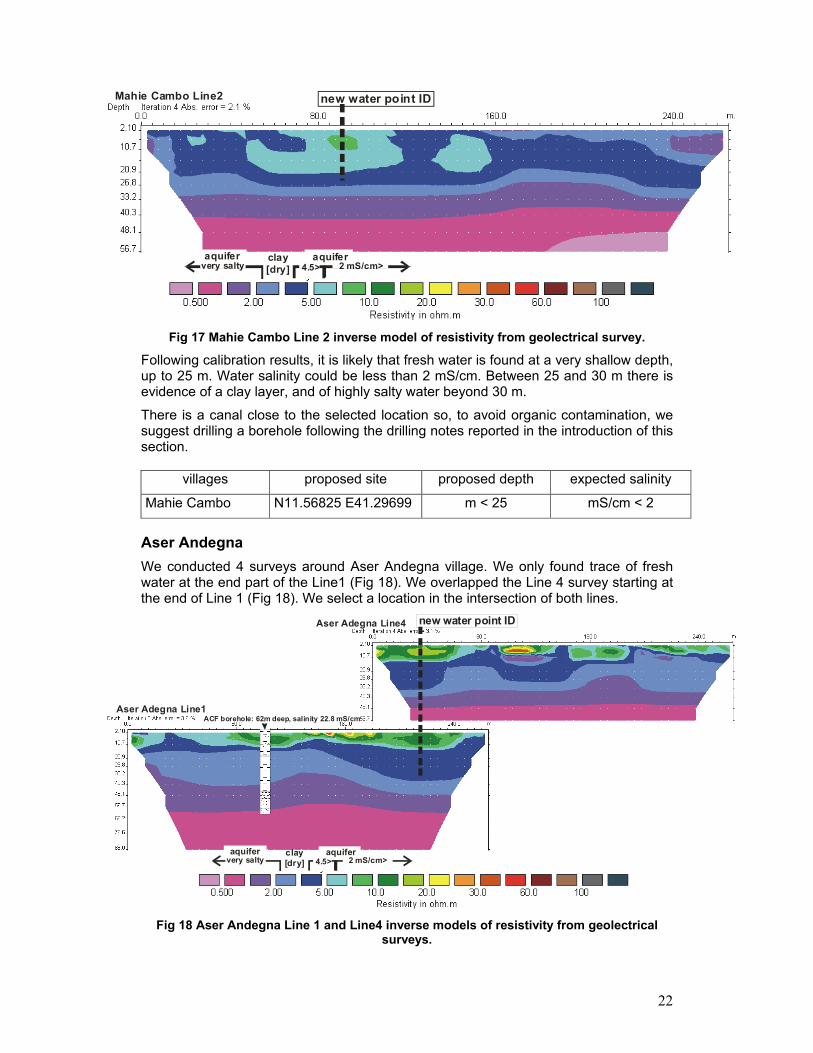
Fig 17 Mahie Cambo Line 2 inverse model of resistivity from geolectrical survey.
Following calibration results, it is likely that fresh water is found at a very shallow depth, up to 25 m. Water salinity could be less than 2 mS/cm. Between 25 and 30 m there is evidence of a clay layer, and of highly salty water beyond 30 m.
There is a canal close to the selected location so, to avoid organic contamination, we suggest drilling a borehole following the drilling notes reported in the introduction of this section.
villages proposed site proposed depth expected salinity
Mahie Cambo N11.56825 E41.29699 m < 25 mS/cm < 2
Aser Andegna
We conducted 4 surveys around Aser Andegna village. We only found trace of fresh water at the end part of the Line1 (Fig 18). We overlapped the Line 4 survey starting at the end of Line 1 (Fig 18). We select a location in the intersection of both lines.
Aser Adegna Line1
Aser Adegna Line4
ACF borehole: 62m deep, salinity 22.8 mS/cm
new water point ID
clay
[dry]very salty 4.5> 2 mS/cm> aquifer aquifer
Fig 18 Aser Andegna Line 1 and Line4 inverse models of resistivity from geolectrical surveys.

23
We propose a point expecting low to moderate water quality: - ~1 mS/cm up to 15 m - ~3 mS/cm up to 30 m
Between 30 and 45 m there is evidence of a clay layer, and of extremely salty water beyond 45 m.
We suggest digging/drilling up to 15 m and, if yield is not enough, digging/drilling up to 30 m.
villages proposed site proposed depth expected salinity
Aser Andegna N11.48856 E41.33828 m < 15 or
m < 30
~1 mS/cm or
~3 mS/cm
Ibourrimego
We find very positive results in Line1 (Fig.19). We propose two locations, or any location in-between, for drilling/digging. So, the community have a chance for selecting the final location.
Iburrimego Line1new water point ID new water point ID
clay
[dry]very salty 4.5> 2 mS/cm> aquifer aquifer
Fig 19 Ibourrimego Line 1 inverse model of resistivity from geolectrical survey.
The resistivity model shows a first level up to 10 m interpreted as a clay layer. It shows a second level up to 30 m coherent with fresh water values (< 2mS/cm). Between 30 and 40m there is evidence of a clay layer, and of extremely salty water beyond 40m.
villages proposed site proposed depth expected salinity
Iburrimego N11.55041 E41.30262 N11.5503 E41.30194
10 < m < 30 mS/cm < 2

24
Lagifage
After checking Line1, we select a new location (Fig 20).
ACF borehole: 24m deep, dry
Lagifage Line1 new water point ID
clay
[dry]very salty 4.5> 2 mS/cm> aquifer aquifer
Fig 20 Lagifage Line 1 inverse model of resistivity from geolectrical survey.
In the first 20 m around the selected point, the resistivity model shows an anomaly inside a clay level. Beyond 30 m high salinity is expected.
We propose drilling/digging up to 20 m expecting water salinity < 3 mS/cm.
villages proposed site proposed depth expected salinity
Lagifage N11.54205 E41.30881 m < 20 mS/cm < 3
Arado
In the survey Line 1 we identify a very promising zone (Fig 21)
Arado Line1
new water point ID
clay
[dry]very salty 4.5> 2 mS/cm> aquifer aquifer
Fig 21 Arado Line 1 inverse model of resistivity from geolectrical survey.

25
The resistivity model shows a large anomaly interpreted as a moderate porosity zone. Water level looks very shallow (around 5m) and we propose digging or drilling up to 35 m as a maximum. We expect a value of water salinity around 1mS/cm.
villages proposed site proposed depth expected salinity
Arado N11.60503 E41.23047 m < 35 mS/cm ~ 1
Soudan Camp
In Soudan Camp we conduct 4 surveys and in all of them we detected a zone with relatively high resistivity that we interpreted us an old river bed. The Fig. 22 shows a Wenner-alpha survey (Line 4) conducted in the centre of the anomaly.
Soudan Camp Line4 new water point ID
clay
[dry]very salty 4.5> 2 mS/cm> aquifer aquifer
Soudan Camp Line4 new water point ID
clay
[dry]very salty 4.5> 2 mS/cm> aquifer aquifer
Soudan Camp Line4 new water point ID
clay
[dry]very salty 4.5> 2 mS/cm> aquifer aquifer
Soudan Camp Line4 new water point ID
clay
[dry]very salty 4.5> 2 mS/cm> aquifer aquifer
Soudan Camp Line4 new water point ID
clay
[dry]very salty 4.5> 2 mS/cm> aquifer aquifer
Soudan Camp Line4 new water point ID
clay
[dry]very salty 4.5> 2 mS/cm> aquifer aquifer
Soudan Camp Line4 new water point ID
clay
[dry]very salty 4.5> 2 mS/cm> aquifer aquifer
Soudan Camp Line4 new water point ID
clay
[dry]very salty 4.5> 2 mS/cm> aquifer aquifer
Soudan Camp Line4 new water point ID
clay
[dry]very salty 4.5> 2 mS/cm> aquifer aquifer
Fig 22 Soudan Camp Line 4 inverse model of resistivity from geolectrical survey.
We select a location in the middle of the resistivity model. In this location we expect finding a fresh sandy aquifer (<1 mS/cm) up to 15m. Between 15 and 30 m we forecast clay increase in the aquifer. Between 30 and 35 m there is evidence of clay and of high salty water beyond 35m.
villages proposed site proposed depth expected salinity
Soudan Camp N11.60268 E41.21487 m < 30 mS/cm < 1
Huletegna / Lagi Goho
In Huletegna there is a borehole rehabilitated by ACF. It was abandoned for 10 years and ACF cleaned it, ordered water analysis and finally installed a hand dug pump. Even if analysis report positive results, because of turbidity and salinity the community dislike drinking the water. That’s why now we propose a new water point in Huletegna (Fig. 23).
Huletegna / Lagi goho Line1
borehole: 16m deep, salinity 4.45 mS/cm new water point ID
Fig 23 Huletegna Line 1 inverse model of resistivity from geolectrical survey.

26
We select a new location at the end of the Line 1 where formations seem more porous. Because of the location is in the border of the model, uncertainty is big. The results obtained in Gera can be extrapolated here to reduce risk.
We suggest not drilling beyond 25 m and we expect finding water salinity < 3 mS/cm. There is a canal close to the selected location so, to avoid organic contamination, we suggest drilling a borehole following the drilling notes reported in the introduction of this section.
villages proposed site proposed depth expected salinity
Huletegna / Lagi Goho
N11.56762 E41.28869 m < 25 mS/cm < 3
Califage
Califage is not located in Detbahari area but in the opposite side of the Awash Delta. We include it in this section because both of the contexts are similar from a geoelectrical point of view.
In Califage we conduct 4 surveys but only one, Line 3 (Fig 24), shows evidence of fresh water possibilities. The survey Line 1 was conducted close to a salty borehole drilled by World Vision.
Califage Line3
Califage Line1
WV borehole: 86m deep, salinity 13 mS/cm
clay
[dry]very salty 4.5> 2 mS/cm>
aquifer aquifer
new water point ID
Fig 24 Califage Line 1 and Line 3 inverse models of resistivity from geolectrical surveys.
According to Detbahari correlations, the resistivity model Califage Line 1 shows a large highly salty medium. A borehole in this position has no chance of finding fresh water.
On the other hand, at the end of the Line 3 we identified a hopeful zone. We forecast a moderate porous zone with fresh water (< 3mS/cm) around the selected point up to 30 m.

27
villages proposed site proposed depth expected salinity
Califage N11.66693 E41.32069 m < 30 mS/cm < 3
7. Reference M.H.Loke Tutorial : 2-D and 3-D electrical imaging surveys. 2004
Geotomo Software. Res2dinv 3.5 software.
Iris Instrument. Electre II v04.02.00 software.
Iris Instrument. Prosys v09.05.00 software.
Landsat Satellite image zone38-5 on Jul 17 18:56:57 2000. NASA. https://zulu.ssc.nasa.gov/mrsid/mrsid.pl
Bouet Caroline. Etude et cartographie du couvert végétal de la basse vallée de l’Awash, région Afar, Ethiopie. 2002 CIRAD-EMVT
Silvain Sabrina. Household Economy Baseline Survey, Zones 1 and 4 Afar National Regional State. 2003 ACF-Ethiopia.
Marzan Ignacio. Analysis for water perspectives in an arid pastoral-agropastoral context: Afar region in Ethiopia. 2004 ACF-Ethiopia.
8. Annex
We have compiled this table summarizing information from this report and the
ACF 2004 report.
villages Woreda Kebele
proposed site for
drilling/digging
proposed depth
forecast water quality
Context
Gurmudele Dubti N11.73736 E41.03542
12< m < 24 good
25 families. Pastoral village close to an abandoned Awash River bed. No permanents water points.
Wahalimat ID 1 N11.93367 E41.43821
10< m < 40 good
Wahalimat ID 2
Eli Daar Wahalimat ke
Haraytu N11.93432 E41.43873
40 < m ?
Basaltic area. 80 families. Pastoral villages on a main road. No permanent water points for people and animals. -1 school
Serdo Dubti N11.9610N E41.3042E
65 < m ?
Basaltic area. 40 families. Pastoral villages on a main road. No permanent water points. -1 school -1 clinic
Guyah Line2 N12.4075 E41.18174
20 < m < 65 good
Guyah Line4
Dubti N12.4259 E41.1821
10 < m < 65 good
Basaltic area. 80 families. Pastoral villages on Afdera road. No permanent water points. -1 school -1 clinic
Gulubele Dubti N12.5454 E41.13071
10 < m <90 good
Basaltic area. 87 families. Pastoral village on Afdera road. -1 traditional well in very bad condition -1 clinic

28
Gera Dubti
Hannakies ke Arado
N11.57088 E41.28590
m < 25 mS/cm < 3
Detbahari area. 26 families. Agropastoral village close to the cotton plantation. No drinking water point. -1 school
Mahie Cambo Dubti
Hannakies ke Arado
N11.56825 E41.29699
m < 25 mS/cm < 2
Detbahari area. 56 families. Agropastoral village close to the cotton plantation. No drinking water point.
Aser Andegna Dubti
Megenta N11.48856 E41.33828
m < 15 or
m < 30
~1 mS/cm or
~3 mS/cm
Detbahari area. 60 families. Agropastoral village close to the cotton plantation. No drinking water point. -1 clinic -1 school
Iburrimego Dubti
Megenta
N11.55041 E41.30262
and N11.5503 E41.30194
10 < m < 30 mS/cm < 2
Detbahari area. 50 families. Agropastoral village close to the cotton plantation. No drinking water point.
Lagifage Dubti
Megenta N11.54205 E41.30881
m < 20 mS/cm < 3
Detbahari area. 50 families. Agropastoral village close to the cotton plantation. No drinking water point.
Arado Dubti
Hannakies ke Arado
N11.60503 E41.23047
m < 35 ~1 mS/cm
Detbahari area. Agropastoral village close to the cotton plantation. No drinking water point.
Soudan Camp Dubti
Hannakies ke Arado
N11.60268 E41.21487
m < 30 mS/cm < 1
Detbahari area. Agropastoral village close to the cotton plantation. No drinking water point. -1 clinic
Huletegna / Lagi Goho
Dubti Megenta
N11.56762 E41.28869
m < 25 mS/cm < 3
Detbahari area. 37 families. Agropastoral village close to the cotton plantation. -1 borehole in bad condition.
Califage Ayssaita N11.66693 E41.32069
m < 30 mS/cm < 3
Similar to Detbahari context. 70 families. Pastoral. No drinking water point. -1school -1clinic