Embed Size (px)
Citation preview
Volume 8, Number 2 65
World Customs Journal
Geospatial intelligence: Can Customs learn from the
policing perspective?John de Belle1
Abstract
Every day, customs administrations around the world collect enormous amounts of data regarding the movement of passengers, vehicles, vessels, aircraft, cargo and currency and this stream of data is growing. With this expanding supply of data – and shrinking customs resources – a smarter way of making sense of this data is required, including mining the data to identify patterns of activity. Customs administrations could consider how policing agencies are mining their data holdings to derive meaningful intelligence and become intelligence-led organisations. It is postulated that customs administrations could learn from policing agencies (the scientific discoveries, the computing advances) and adapt developments by those agencies to the customs environment. This paper provides an overview of how policing agencies use geospatial intelligence and identifies ways that customs administrations would benefit from considering its use in collaborative border management.
IntroductionThis paper on geospatial intelligence looks at the factors that have influenced decisions by police administrations to make use of Geographic Information Systems (GIS). The results of scientific enquiry in the field of criminology that are used to explore some of the similarities between customs administrations and policing environments are discussed as are the systems that have been developed to address problems of crime and disorder. Finally, this paper offers a possible solution as to how those systems can be applied to solve similar issues facing customs administrations.
A GIS can generally be described as a database management system used for the visualisation and statistical analysis of geographically referenced data. As Longley, Goodchild, Maguire and Rhind explain:
Identifying where something exists or happens … is central to GIS … the ability to compare different properties of the same place … to discover relationships and correlations and perhaps even explanations, is often presented as GIS’s greatest advantage (Longley et al. 2011, p. 355).
Geospatial intelligence, in this context, represents the ability to derive additional knowledge from the location data to predict and solve problems (Longley et al. 2011, pp. 11-12).
Policing agencies map crime for a number of reasons. They record crimes and calls for service which ‘provides a wealth of information about local crime activity that is readily retrievable from modern computer systems2 [and] has been regarded … as one of the best methods of maximising the generation of crime intelligence at minimum cost’ (Ratcliffe 2000, p. 313).

66 Volume 8, Number 2
International Network of Customs Universities
Drawing on policing research and development it may be possible to identify patterns of high-risk activity and look for these patterns in cross-border interactions. This would allow customs administrations to more effectively mine their data holdings to derive additional meaningful intelligence. As indicated by Chainey and Ratcliffe (2005, p. 2) ‘this material can be used for crime and intelligence analysis, and in turn used to better recognise patterns of crime that can be targeted for action, patterns that evidence suggests … officers are not necessarily aware of’. This additional intelligence would enable customs administrations to move from traditional linear lines of enquiry to being better able to identify high-risk patterns of cross-border offending sooner rather than later.
The scienceGeospatial intelligence is not a new field of study. Chainey and Ratcliffe (2005, p. 3) note that ‘the geographical analysis of crime has also shown strong parallels with the field of spatial epidemiology and continues today to learn from this related field’. One of the earliest uses of mapping in the modern era can be attributed to physician Dr John Snow in 1854. Snow, widely regarded as the father of modern epidemiology, traced the source of a cholera outbreak in central London by mapping the locations of deaths and local water sources. Snow correctly identified the cholera source to a contaminated water pump (Longley et al. 2011, p. 354).
The idea of place in relation to crime has long been recognised for its importance in policing. Criminal activity can be better understood by exploring the geographical components, including identification of patterns and concentrations of crime (Chainey & Ratcliffe 2005, p. 1). To understand why such emphasis has been placed on location requires examination of crime statistics, unreported crime, factors influencing the reporting of crime, ‘victimless’ crimes and the influence of recidivism by location or offender.
According to Chainey and Ratcliffe (2005, p. 65) ‘the Australian Institute of Criminology has estimated that for every 100 crimes that are committed in Australia, only 40 are reported to the police and only 32 are actually recorded’. The New South Wales Bureau of Crime Statistics and Research (2004, p. 3) identifies a number of issues surrounding reported crime including differing crime types having different reporting rates, suggesting a number of factors influence reporting. Walker (1992, p. 151) notes a similar level of reporting in North America ‘since only 37% of all crimes are reported’.
Carcach (1997, pp. 1-6) found that the seriousness of the offence was one of the most notable factors influencing the reporting of crime. Non-reporting, on the other hand, was primarily influenced by the perception that many matters are perceived as minor and thus do not necessitate reporting or police involvement. Makta (1990, pp. 1-8) concurs: ‘the recorded rate of some offences is so poorly related to the actual number ... we should not even attempt to infer trends ... [for example,] drug offences are rarely reported’. Walker (1992, p. 162) supports this view noting that prostitution, gambling and narcotics are regarded as ‘victimless crimes’.
Interestingly, Walker (1992, p. 158) identifies one strategy for targeting crime as ‘the career criminal approach ... which estimates that a very small number of people ... commit an extremely high percentage of all the serious crime committed by the total group’. Petersilia (1989, p. 245) reaches a similar conclusion noting ‘the small number of chronic recidivists who account for a large amount of serious crime’. This view is echoed by Ratcliffe (2003, p. 2).
Drawing further on the prolific nature of these recidivist offenders, Canter (1994, pp. 96-7) observes that criminals are ‘more vulnerable in their history than in [their] future’. Canter’s research examines the relationship between recidivist burglars and their confirmed burglary locations which reveals an interesting ‘circle hypothesis’, namely that in many instances, ‘the crimes were surprisingly local to where the offender lived’. The suggestion of recidivist offenders tied to particular locations appears to be consistent across different crime types (burglaries, rapes, homicides) and, according to Chainey and

Volume 8, Number 2 67
World Customs Journal
Ratcliffe (2005, p. 303) ‘geographical profiling was developed to help police locate serial killers, rapists and arsonists ... also being applied to many other crime types such as robbery and burglary where an unidentified person is known to have carried out crimes at a series of geographic points’.
Branca (1998, p. 17) considers the spatial nature of recidivist offenders and, in an Australian context, identifies that Canter’s research and theories could be applied to Australian conditions for rape, burglary and arson. Chainey and Ratcliffe (2005, p. 126) identify three principal types of spatial patterns: uniform, random and clustered, with clustered patterns most often associated with crime data. Expanding on the clustering phenomena, Chainey and Ratcliffe (2005, pp. 146-7) recognise that ‘good cartographic design is important in hotspot mapping as it clearly identifies areas that persistently suffer from crime ... hotspot maps are therefore a blend of good cartographic design and robust methodology, and are a first step towards exploring crime patterns in more detail’. Chainey and Ratcliffe (2005, p. 312) extrapolate the idea of criminal hotspots into a subtle means of targeting through ‘self-selection … based on the hypothesis that “people who are the most committed criminals are also the most versatile, and will not willingly be bound by law or convention of any kind”’.
The system from the policing perspectiveEsri Australia define GIS as:
Technology [that] maps the geography of an organisation’s data to expose patterns and relationships otherwise hidden in the information labyrinths of numeric tables and databases. By visually representing data on a map, complex scenarios are translated into a universal language – one that enables employees at all levels to make informed decisions confidently and in a timely manner (Esri Australia 2013a).
Expanding on this definition, Esri Australia suggests that ‘GIS unlocks location intelligence – the knowledge that comes from taking a geographic view of information … reveal[ing] well-kept secrets and mak[ing] new discoveries. In the 21st century, this equates to business breakthroughs … innovation and [other] benefits’ (Esri Australia 2013b).
Following on from the science of geospatial intelligence, Longley et al. (2011, p. 16) offer a definition of a GIS as ‘a tool for revealing what is otherwise invisible in geographic information’. This is especially important when considering that:
Location is inherent in all organisational data: people have residences, assets have proximities, employees have worksites and parcels have both origins and destinations. Over 80% of all data contains a location component. By visualising and exploring the relationships within this data; and using the resulting discoveries to guide decision-making – you are effectively leveraging ‘location intelligence’ (Esri Australia 2013c)
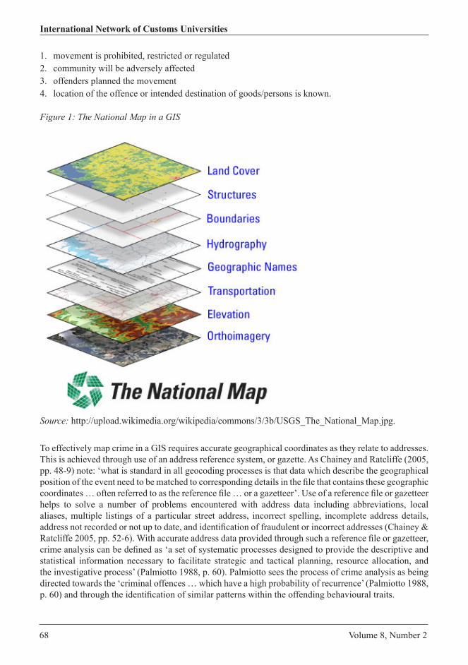
Figure 1 is an example of a map within a GIS, showing the different layers of information that contribute to the overall image.
Chainey and Ratcliffe, citing Professor P Jeffrey Brantingham, note that there are four dimensions to every crime:
1. a legal dimension (a law must be broken)2. a victim dimension (someone or something has to be targeted)3. an offender dimension (someone has to do the crime)4. a spatial dimension (it has to happen somewhere) (Chainey & Ratcliffe 2005, p. 79).
These same factors apply to cross-border interactions, for example, movement of goods/persons across international borders where the:
68 Volume 8, Number 2
International Network of Customs Universities
1. movement is prohibited, restricted or regulated2. community will be adversely affected3. offenders planned the movement4. location of the offence or intended destination of goods/persons is known.
To effectively map crime in a GIS requires accurate geographical coordinates as they relate to addresses. This is achieved through use of an address reference system, or gazette. As Chainey and Ratcliffe (2005, pp. 48-9) note: ‘what is standard in all geocoding processes is that data which describe the geographical position of the event need to be matched to corresponding details in the file that contains these geographic coordinates … often referred to as the reference file … or a gazetteer’. Use of a reference file or gazetteer helps to solve a number of problems encountered with address data including abbreviations, local aliases, multiple listings of a particular street address, incorrect spelling, incomplete address details, address not recorded or not up to date, and identification of fraudulent or incorrect addresses (Chainey & Ratcliffe 2005, pp. 52-6). With accurate address data provided through such a reference file or gazetteer, crime analysis can be defined as ‘a set of systematic processes designed to provide the descriptive and statistical information necessary to facilitate strategic and tactical planning, resource allocation, and the investigative process’ (Palmiotto 1988, p. 60). Palmiotto sees the process of crime analysis as being directed towards the ‘criminal offences … which have a high probability of recurrence’ (Palmiotto 1988, p. 60) and through the identification of similar patterns within the offending behavioural traits.
Figure 1: The National Map in a GIS
Source: http://upload.wikimedia.org/wikipedia/commons/3/3b/USGS_The_National_Map.jpg.
Volume 8, Number 2 69
World Customs Journal
Goldstein (1990, p. 37) takes the views of Palmiotto a step further, indicating that ‘crime analysis has been used to identify offenders and interrupt crime patterns [emphasis added] rather than to gain the kind of knowledge and insights that might be used to affect the conditions that accounted for the criminal conduct’. Goldstein (1990, p. 44) also suggests that the development of alternative methods to ‘respond to commonly recurring problems represents unique opportunities for novel solutions’.
Establishing Canter’s (1994, p. 104) ‘circle hypothesis’ referred to above, appears to have relevance across a number of different crime types including burglaries, serial rapists and serial murders. Taylor suggests a slight shift of focus from offender to place, resulting in reductions in both crime and disorder, and proposes adopting techniques related to spatial epidemiology to ‘describe and understand how crime and disorder cluster in both space and time’ (Taylor 1998, p. 1). These techniques reveal that ‘crime data and police service calls that are “geocoded” reveal concentrations of crime in a few hot places … if we know exactly where and when crimes are taking place, we should be able to control crime more effectively’ (Taylor 1998, p. 2). Taylor suggests that repeat victimisation was also identified as playing an important role in the identification of ‘hot’ spots (Taylor 1998, p. 4). Chainey and Ratcliffe (2005, p. 164) concur, noting that identification of hotspots ‘identif[ies] where the local averages … are significantly different to the global averages’. In addition to identifying hotspots, Chainey and Ratcliffe (2005, p. 255) suggest that time can also play an important role in defining hotspots, noting ‘aoristic analysis3 is … a flexible way for analysts to better understand the spatial and temporal patterns of their crime data’.
The evidenceInteractions between customs administrations and the public, including industry, bear notable similarities with traditional reactive-based models of policing. Most notably, the critical issue here falls into being able to recognise a pattern of activity. The current linear nature of customs enquiries limits identifying patterns of activity and does not account for changes over time. Moreover, current techniques are problematic in identifying irregularities. For example, in 2007, the Australian Customs and Border Protection Service conducted an interception of cocaine in car parts from North America, consigned to a beachside address in Cronulla, New South Wales. The interception was not itself overly significant, however, it was not until after the interception that post-seizure research identified almost 100 previous successful importations to the same address in the preceding months. As Chainey and Ratcliffe (2005, p. 274) point out, ‘Mapping crime events … may identify a hotspot of which decision-makers were unaware … having mapping tools that can identify high repeat victimisation sites can be a quick first step to the identification of a problem’.
Identification of patterns as they are occurring/emerging is one of the strengths of mapping in a GIS environment, and is not limited to any particular cross-border transaction or commodity type. Could the above cocaine importations have been identified earlier if the address had been identified as a recidivist high-volume location leveraging the spatial and temporal attributes of a GIS? The answer is most likely ‘yes’.
The adoption and uses of GIS are increasing, including by logistics and freight forwarding companies. This is something of which customs administrations should be aware and consider the potential for data exploitation. At the 2010 Esri International User Conference, Haas, McLeod, Dezemplen and Conger identified the application of spatial data to support the FEDEX mission, applications and processes worldwide, including: … decision making for the routing and scheduling of thousands of vehicles … minimising costs such as mileage, overtime of workforce, efficient routing … effective delivery methods, leading to higher productivity and greater customer satisfaction (Haas et al. 2010, p. 1). Figure 2 is an example of an open-access law enforcement GIS.

70 Volume 8, Number 2
International Network of Customs Universities
Figure 2: Identifying the crime hotspot, central business district, Savannah, Georgia USA
Source: RAIDS Online 2013 (reproduced with permission).
In 2006, Australia implemented tighter controls on the retail purchase of medications containing pseudoephedrine. This was an attempt to halt the illicit diversion of pseudoephedrine for use in the manufacture of amphetamine-type substances. As a result of these tighter controls, data from the International Narcotics Control Board (2002–2012) has shown a steady increase in the weight of intercepted ephedrine, ephedrine preparations, pseudoephedrine and their preparations from a combined total of 152 kg in 2002 to 1,713 kg in 2011, with a record seizure weight of 2,696 kg in 2008.
A number of factors have influenced these seizures including tighter domestic controls which have forced criminal groups to source the precursors from countries with lower levels of regulation and enforcement, and a number of Asian countries have been identified as sources of these precursors with resulting detections clustering in similar ethnic communities within Australia.
The solutionAccording to Longley et al. (2011, p. 43) there is a ‘wider realisation that geography provides the most effective way of organising enterprise-wide information systems’. Chainey and Ratcliffe (2005, p. 262) concur, noting that ‘a geographic focus is one of the most effective ways to utilise limited resources and people’. Longley et al. (2011, pp. 48-9) cite examples that range from economic development, infrastructure, law enforcement, environmental monitoring and geodemographics, and point out that GIS can be used at tactical, operational and strategic levels (Longley et al. 2011, pp. 65-6).
Customs administrations, with limited resources and increasing demands on those resources, must move from the traditional linear lines of enforcement to one that can far better account for temporal and
Volume 8, Number 2 71
World Customs Journal
disparate data variables. This view is not dissimilar to the observations of Ratcliffe (2003, p. 2) that there is ‘an inability of the traditional, reactive model of policing to cope with the rapid changes in globalisation which have increased opportunities for transnational organised crime’.
There are a number of opportunities within the global logistics and supply chain network that can clearly be exploited through industry adoption of geospatial technology. Customs administrations would be well placed to co-opt industry developments, as identified earlier in the example of FEDEX’s use of geospatial data, to enable greater returns on investment for all parties. To illustrate, the overwhelming majority of customs administrations are signatories to the Harmonized Commodity Description and Coding System (the Harmonised System) which is designed to achieve uniform classification of commodities. As an extension to the widespread use of the Harmonised System, customs administrations could adopt a requirement to use ISO 191314 geographic information-compliant datasets, for industry reporting requirements; for example, in relation to cargo reporting and import declarations. Use of these datasets would have several notable benefits for both industry and customs administrations.
In Australia, the authoritative equivalent of an ISO 19131 dataset is known as G-NAF, or Geocoded National Address File which is ‘the authoritative index of Geocoded Australian addresses. This … dataset contains more than 13 million physical addresses that are sourced from address custodians from each state and territory, the Australian Electoral Commission and Australia Post. G-NAF makes it possible to verify a physical address in Australia and locate its position (PSMA 2013). Similar datasets exist for the United Kingdom (AddressBase 2013), Canada (GeoBase 2013) and New Zealand (LINZ 2013).
This author’s opinion is that the methodology used by policing agencies to map crime data can be similarly replicated in the customs environment. This could be achieved through:
• the increasing availability of national address datasets• positive results from the use of geospatial intelligence by different policing agencies in different
countries• similar results obtained by mapping crime data across different crime types (homicides, rapes,
burglaries, arson, and so on).
Widespread adoption of address standard ISO 19131 in the customs environment would enhance the community protection role that customs administrations perform in concert with their revenue roles. The standard provides the ability to effectively use trade and statistical data for multiple purposes, resulting in a greater return on investment and enhancing a customs administration’s ability to maximise its returns from its data holdings. Spatial analysis can reveal things that might otherwise be invisible – it can make what is implicit explicit … turning data into useful information (Longley et al. 2011, p. 352).
Adoption of ISO 19131 for customs reporting requirements would have several benefits:
Through the investment in detailed base mapping data for their GIS and a gazetteer that is comprehensive, up to date, centrally administered and well maintained, the capture of address data or location data of where crimes happen is now significantly more efficient and accurate … The application of an automated … geocoding process … helps [to build] … confidence that consistent processes have been applied to the data … knowing their data are accurate, and that the output is reliable (Chainey & Ratcliffe 2005, pp. 58; 65).
Adoption of ISO 19131 for use by national customs administrations for internal seizure data, intelligence information and other diverse data types, such as air waybills, bills of lading, advanced passenger data and international currency movement reports would represent the foundation of an integrated geospatial intelligence tool. Such a tool would also provide a significant timesaver, reducing the number of separate database enquiries that may need to be performed.
An integrated geospatial tool encompassing multiple modes of cross-border interactions (post, sea and air cargo, passengers, currency, intelligence) provides the opportunity to have a more holistic overview

72 Volume 8, Number 2
International Network of Customs Universities
of the environment. Such a view would enable significant enhancement to threat assessments of cross-border activity (pattern analysis, hotspots, recidivist address use) and would be more agile and adaptive to changes in the operating environment.
ConclusionsIt is important to note that until further study is conducted and supporting evidence emerges, geospatial intelligence should be best viewed as an aid not a replacement to traditional profiling techniques in the customs environment. Without bearing in mind the significant policing emphasis on data quality, any attempt to introduce a geospatial intelligence capability without appropriate data quality controls would be fraught with difficulty. Data quality = data integrity = meaningful analysis. Geospatial intelligence, from the policing perspective, appears to be commodity-agnostic and is scientifically based. Again, until further study is conducted and supporting evidence emerges, its value in a customs environment is largely theoretical, as opposed to empirical.
Geospatial intelligence represents an opportunity to reduce the incidence of fraud in the customs, global logistics and supply chain sectors whilst providing a significant return on investment through the multiple use of data. Moreover, a geospatial intelligence environment would not appear to be adversely affected by increases in information volume associated with increasing trade and travel. Now is the opportune time for customs administrations to embrace the opportunities identified by policing agencies and become geospatially intelligence-aware.
References
Branca, P 1998, ‘Geographic profiling: a new tool in serial crime investigation’, Intelligence Digest, August, pp. 16-17.
Canter, D 1994, ‘Criminal maps’, in Criminal shadows, HarperCollins, London, pp. 95-120.Canter, D & Larkin, P 1993, ‘The environmental range of serial rapists’, Journal of Environmental
Psychology, vol. 13, pp. 63-69.Carcach, C 1997, ‘Reporting crime to the police’, Trends and issues in crime and criminal justice, Paper
No. 68, Australian Institute of Criminology, Canberra, pp. 1-6.Chainey, S & Ratcliffe, J 2005, GIS and crime mapping, John Wiley, London. Eck, JE, Chainey, S, Cameron, JG, Leitner, M & Wilson, RE 2005, ‘Mapping crime: understanding hot
spots’, Special Report, National Institute of Justice, US Department of Justice, Washington, DC.Esri Australia 2013a, About GIS, Learn about Geographic Information Systems technology, viewed
16 October 2013, https://esriaustralia.com.au/about-gis. Esri Australia 2013b, History of GIS, History of Geographic Information System technology, viewed
16 October 2013, https://esriaustralia.com.au/about-history-of-gis. Esri Australia 2013c, What is Location Intelligence: Definition & case studies, viewed 16 October 2013,
https://esriaustralia.com.au/about-location-intelligence. GeoBase 2013, viewed October 2013, www.geobase.ca/geobase/en/index.html. Haas, J, McLeod, J, Dezemplen, R & Conger, R 2010, ‘Using GIS in strategic planning and execution at
FedEx Express’, paper 1510 presented at ESRI 2010 International User Conference, pp. 1-15, viewed June 2013, http://proceedings.esri.com/library/userconf/proc10/uc/papers/pap_1520.pdf.
International Narcotics Control Board, ‘Seizures of substances in Tables I and II of the 1988 Convention as reported to the International Narcotics Control Board during the past 10 years’, viewed October 2013, www.incb.org/documents/PRECURSORS/TABLES/TableI_Seizures_2002-2012.xls.

Volume 8, Number 2 73
World Customs Journal
ISO/TC 211 Geographic Information/Geomatics, 19131:2007 Data Product Specifications, Project Information Fact Sheet 19131, viewed 16 October 2013, www.isotc211.org/Outreach/Overview/Factsheet_19131.pdf.
LINZ 2013, viewed October 2013, www.linz.govt.nz/about-linz/linz-data-service/dataset-information. Longley, PA, Goodchild, MF, Maguire, DJ & Rhind, DW 2011, Geographic information systems and
science, John Wiley, Hoboken, NJ.Matka, E 1990, ‘Uses and abuses of crime statistics’, Crime and Justice Bulletin, no. 11, Bureau of
Crime Statistics and Research, Sydney, pp. 1-8.NSW Bureau of Crime Statistics and Research 2004, ‘Overview of major trends, 2003–2004 New South
Wales’, NSW Recorded crime statistics 2004, Bureau of Crime Statistics and Research, Sydney, pp. 3-5.
Ordnance Survey 2013, AddressBase, viewed October 2013, www.ordnancesurvey.co.uk/business-and-government/products/addressbase-products.html.
Palmiotto, MJ (ed.) 1988, ‘Crime pattern analysis: an investigative tool’, in Critical issues in criminal investigation, 2nd edn, Anderson Publishing, Cincinnati, OH, pp. 59-69.
Pease, K & Laycock, G 1999, ‘Revictimisation: reducing the heat on hot victims’, Trends and issues in crime and criminal justice, Paper No. 128, Australian Institute of Criminology, Canberra.
Petersilia, J 1989, ‘The influence of research on policing’, in Critical issues in policing, RG Durham & GP Alpert (eds), Waveland Press, Prospect Heights, IL, pp. 230-47.
PSMA Limited 2013, G-NAF, viewed 16 October 2013, www.psma.com.au/?product=g-naf. RAIDS Online 2013, viewed January 2013, www.raidsonline.com. Ratcliffe, JH 2000, ‘Implementing and integrating crime mapping into a police intelligence environment’,
International Journal of Police Science and Management, vol. 2, no. 4, pp. 313-23.Ratcliffe, JH 2003, ‘Intelligence-led policing’, Trends and issues in crime and criminal justice, Paper
No. 248, Australian Institute of Criminology, Canberra, pp. 1-6.Taylor, RB 1998, Crime and small-scale places: what we know, what we can prevent, and what else we
need to know, National Institute of Justice, US Department of Justice Washington, DC, pp. 1-16.Walker, S 1992, ‘The police and crime’, in The police in America: an introduction, 2nd edn, McGraw-
Hill, New York, NY, pp. 141-74.
Notes1 This paper represents the author’s views and stems from personal, independent research. It does not necessarily reflect the
views of the Australian Customs and Border Protection Service on the issue. The author acknowledges and thanks Charles Sturt University, Australia, for opening his eyes to a whole new world of possibilities. The author maintains a website (www.customscollector.com/) dedicated to the cataloguing and collection of customs insignia from around the world.
2 The identification of specific software, systems or companies does not necessarily represent an endorsement; it is used to illustrate a particular point.
3 Aoristic analysis: ‘A spatio-temporal tool that calculates the probability that a crime event occurred within a given time period within the time span … designed to assist with the analysis of offences where it is not possible to determine the actual time of offence’ (Chainey & Ratcliffe 2005, p. 251).
4 ISO/TC211 19131 Fact Sheet.

74 Volume 8, Number 2
International Network of Customs Universities
John de BelleJohn de Belle joined the Australian Customs Service in 1990, and is now a Senior Customs Officer, Enforcement Operations, Sydney, with the Australian Customs and Border Protection Service. In 2004, he completed a Bachelor of Policing and was awarded a Graduate Diploma in Criminal Intelligence by Charles Sturt University in 2008. John received Chief Executive Officer awards in 2009 (Operation Interstice) and in 2012 (Operation Quadrel) as an operational member of those teams.