Embed Size (px)
Citation preview
GEOSPATIAL PORTAL ROLES & RESPONSIBILITIES OFFICE OF THE CIO
1
Geospatial Portal Operations
Roles and Responsibilities
Version 4.0
GEOSPATIAL PORTAL ROLES & RESPONSIBILITIES OFFICE OF THE CIO
2
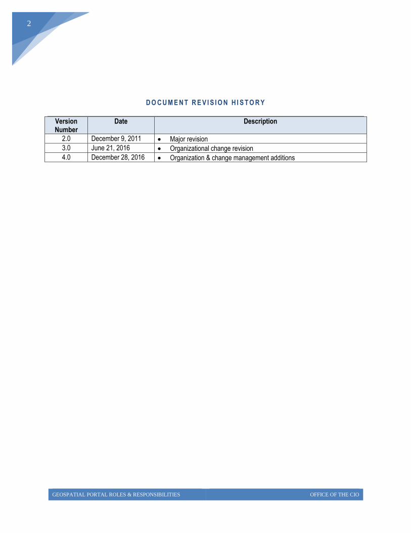
D O C U M E N T R E V I S I O N H I S T O R Y
Version Number
Date Description
2.0 December 9, 2011 Major revision
3.0 June 21, 2016 Organizational change revision
4.0 December 28, 2016 Organization & change management additions
GEOSPATIAL PORTAL ROLES & RESPONSIBILITIES OFFICE OF THE CIO
3
Table of Content
1.1 Overview .......................................................................................................................... 4
1.2 Portal Operational Scope .................................................................................................. 5
1.3 Portal Governance ............................................................................................................ 5
1.4 Participating Groups ......................................................................................................... 5
1.5 Geospatial Stewards and Portal Operations Coordination ............................................... 9
GEOSPATIAL PORTAL ROLES & RESPONSIBILITIES OFFICE OF THE CIO
4
1.1 Overview
Having a common point of access for geospatial data, imagery and associated services increases
efficiencies across the agencies and support transparency in state government.
We do this by reducing duplicate data and imagery maintenance at multiple agencies, with its
associated infrastructure and data storage. It also improves data quality through the use and
maintenance of shared corporate level data, imagery and service assets.
This document describes the significant roles and responsibilities for the operations of the
Geospatial Portal. The roles and responsibilities described in this document are subject to change
and further adjustment as experience is gained in the joint spatial data management on a shared
enterprise infrastructure.
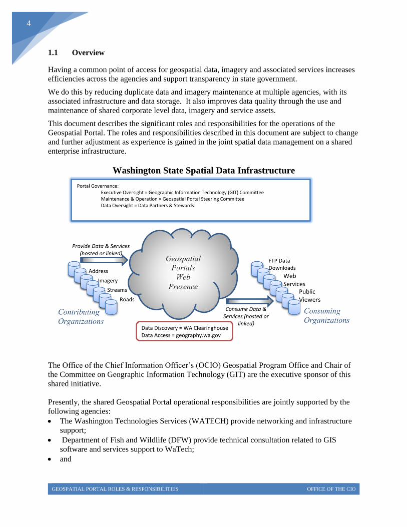
Washington State Spatial Data Infrastructure
The Office of the Chief Information Officer’s (OCIO) Geospatial Program Office and Chair of
the Committee on Geographic Information Technology (GIT) are the executive sponsor of this
shared initiative.
Presently, the shared Geospatial Portal operational responsibilities are jointly supported by the
following agencies:
The Washington Technologies Services (WATECH) provide networking and infrastructure
support;
Department of Fish and Wildlife (DFW) provide technical consultation related to GIS
software and services support to WaTech;
and
Provide Data & Services (hosted or linked)
Consume Data & Services (hosted or
linked)
Web Services
FTP Data Downloads
Public Viewers
Portal Governance: Executive Oversight = Geographic Information Technology (GIT) Committee
Maintenance & Operation = Geospatial Portal Steering Committee
Data Oversight = Data Partners & Stewards
Data Discovery = WA Clearinghouse Data Access = geography.wa.gov
Streams
Roads
Address
Imagery
GEOSPATIAL PORTAL ROLES & RESPONSIBILITIES OFFICE OF THE CIO
5
The Department of Ecology (ECY) provides data management assistance to agencies on how
to prepare their data and services for publication on the Geospatial Portal.
1.2 Geospatial Portal Operational Scope
The Geospatial Portal hosts geospatial data and imagery of statewide interest in Washington.
Additional content will be added over time and will support additional functional capabilities.
Presently, the Portal is accessible to twenty-five state agency funding partners. A public view
into the majority of the state’s geospatial data holdings was implemented in 2014.
1.3 Geospatial Portal Governance
Careful coordination with state agencies was conducted in order to garner support for this
initiative. On-going Geospatial Portal oversight is coordinated through the Geospatial Portal
Steering Committee which hosts representative from the funding agencies. This committee is a
subcommittee to the GIT Committee.
The Office of the Chief Information Officer’s (OCIO) Committee on Geographic Information
Technology (GIT) is the Geospatial Portal’s executive decision making body and is responsible
for staffing the Geospatial Portal Steering Committee
The Geospatial Portal Steering Committee represents the Portal interests and provides
governance oversight to the Geographic Information Technology (GIT) Committee and data
theme stewards. It also oversees the on-going operations of this shared, enterprise infrastructure
and acts as the agency Points of Contact with its constituents insuring coordination and support.
The Committee is comprised of two subgroups: Management and Technical Operations.
The Portal’s Management Group handles the agency interests of the data theme partners
and coordinates this work through Geospatial Portal Steering Committee
The Portal’s Technical Operations Group handles the day to day IT related issues and
interface with the infrastructure support staff at Washington Technologies Services
(WATECH).
The Portal Steering Committee is chaired by a representative from a member agency and the
duties of the chair are rotated on a yearly or biennial basis. The term begins in July of each year
and will be voted in by the Portal sub-committee attendees. The chair will be responsible for
setting the agenda, conducting the meetings and assigning a recorder of the meeting notes. The
Chair is also responsible for setting the voting procedures. In the event an issue cannot be
resolved then it will be raised to the GIT for consideration and resolution.
1.4 Geospatial Portal Funding Model
In 2012, DES (now WaTech) and OFM determined that the Geospatial Portal Operations would
be included as part of the DES rate restructuring. A GIS Central Services Allocation (179-GIS)
GEOSPATIAL PORTAL ROLES & RESPONSIBILITIES OFFICE OF THE CIO
6
was set up and OFM included overall rate adjustments into agency budgets for those who had not
previously participated in the Geospatial Portal maintenance and usage. That way, ensuring it
would be revenue neutral for both existing and new adopters. The rates are based on IT FTE’s.
If agencies are interested in using these services then please contact Bill Moneer at WaTech (via
the Solutions Center at [email protected]). To become involved in GIS or its
governance committees please contact Joy Paulus at the OCIO [email protected].
1.5 Participating Groups and Change Management
Outlined in the table below is a list of the Steering Committee functions that assist in
maintenance and operation of the Geospatial Portal. There is a brief description of each of the
groups and their associated roles and responsibilities. The support and participation of these
groups is critical to the success of this initiative.
Participants Description Role
Office of the CIO (OCIO)
Is the executive sponsor for this Enterprise Geospatial Initiatives
Responsibilities:
Executive oversight
Geographic Information Technology Committee (GIT)
Provides executive leadership. This standing committee of the OCIO is charged with representing the strategic interest of a coordinated, enterprise approach to using geographic information technology and, providing leadership for the implementation of cost-effective, collaboratively-developed, spatial data management solutions.
Responsibilities:
Executive decision makers
Provides necessary funding/resources
Provides oversight.
Serves as advocate for Geospatial Portal
Eliminates obstacles to success of the Geospatial Portal
Provides policy direction
Approves charters for framework governance groups
Geospatial Program Office (GPO)
Is currently staffed by the state GIS Coordinator located in the Office of the Chief Information Officer (OCIO).
Responsibilities:
Statewide coordination of GIS activities in WA and Chair of the OCIO GIT Committee
o Provide strategic direction & support
o Enable standardization & consolidation
o Bring technology expertise together to improve service delivery
GEOSPATIAL PORTAL ROLES & RESPONSIBILITIES OFFICE OF THE CIO
7
Participants Description Role
Geospatial Portal Steering Committee
Represents the Geospatial Portal’s interests and provides governance oversight to the GIT Committee and data theme stewards. Work with Department of Enterprise Services (WaTech) on the coordinated enhancements to the Portal and the deployment of data and services.
Responsibilities:
Work with executive sponsors and data theme stewards on the operations and enhancements to the Portal
Identify common approaches to use in access and dissemination of theme data
Oversee portal operations
Coordinate infrastructure acquisition and loading of new data
Coordinate funding
Establish data distribution conditions
Develop and maintain its charter including sponsor acceptance of the charter
Portal Technical Operations Team
Operations and Staffing
Operations Manager. Technical manager that can coordinate with the infrastructure teams (network, security, server admin, mass storage) and independently make day-to-day operational decisions
GIS Application System Administrator. An expert on application related software resident on the portal (Portal Tech. Team)
Data Administrator (ECY/OCIO)
Systems Administrator (WaTech)
Applications Programmer (contracted)
Members:
Jenny Konwinski (OCIO), David Wright (DOR) Applications Software Technical Advisors to WaTech Rich Kim (ECY), Caleb Maki (DNR), Jenny Konwinski (OCIO) Data and Application Publishing Advisor and Support Bill Moneer (WaTech)
Operational Tasks
Administer the base platform hardware and operating system - WaTech
Administer the application software and associated database – WaTech with Agency support
Backup/Recovery procedure -WaTech
System performance monitoring, system tuning –WATECH with agency support
Security Administration logins, passwords, whitelist (WaTech)
Portal Help Desk & communication with users –WaTech (tactical) & Steering Communications (strategic)
Implementing new image sets & transfer of disks – DNR & ECY
Implement new vector data sets & transfer of disks – ECY, DFW, OCIO, DNR, DOH
Create staffing plan – OCIO & Steering Committee
GEOSPATIAL PORTAL ROLES & RESPONSIBILITIES OFFICE OF THE CIO
8
Participants Description Role
Applications development and maintenance – Esri, ECY, DOR, DOH
Software installs and upgrades – WaTech with agency support
Decision to Upgrade software – Steering Committee
Publish services: Test Env. - Agencies; Production Env. –WaTech w/ agency support)
Software License Administration – WaTech with OCIO support
Develop & implement change mgmt. procedures – WaTech w/OCIO support
Architecture planning & expansion – Steering Committee sub committee
Change Management Procedures
Currently, the WaTech Change Advisory Board (CAB) meetings are Tuesday and Thursday
afternoons at 3:30 pm. This is where production changes are reviewed and production changes
scheduled. All requested changes need to be logged beforehand prior to these meetings. Non-
production changes are also logged (for example Melissa Data Updates) but do not go through
the same review before the work is done.
If Emergency Changes need to be approved there is a subset of the CAB meeting attendees
which would get an email and would approve the change through email.
WaTech Notifications are supposed to be sent three days prior to any planned work so that
external customers can be notified. All notification are drafted by the technician, read and
approved by a lead or a supervisor, and then sent to the Service Center for distribution and
notification.
These procedures allow us to log and track work being completed and provide a way to resolve
issues and incidents if they occur because of a production system/application change. Please
keep in mind that the responding technician or on-call tech may not be the same tech that made
the changes.
CAB meetings – Tuesday and Thursday
User Notification – 3 days prior to the work
GEOSPATIAL PORTAL ROLES & RESPONSIBILITIES OFFICE OF THE CIO
9
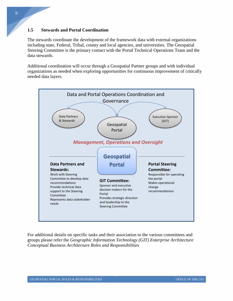
1.5 Stewards and Portal Coordination
The stewards coordinate the development of the framework data with external organizations
including state, Federal, Tribal, county and local agencies, and universities. The Geospatial
Steering Committee is the primary contact with the Portal Technical Operations Team and the
data stewards.
Additional coordination will occur through a Geospatial Partner groups and with individual
organizations as needed when exploring opportunities for continuous improvement of critically
needed data layers.
For additional details on specific tasks and their association to the various committees and
groups please refer the Geographic Information Technology (GIT) Enterprise Architecture
Conceptual Business Architecture Roles and Responsibilities
Geospatial Portal
Steering
Data and Portal Operations Coordination and Governance
Executive Sponsor (GIT)
Data Partners & Stewards
Management, Operations and Oversight
Data Partners and Stewards: Work with Steering Committee to develop data recommendations
Provide technical data support to the Steering Committee
Represents data stakeholder needs
Portal Steering Committee: Responsible for operating the portal Makes operational change recommendations
GIT Committee: Sponsor and executive decision makers for the Portal Provides strategic direction and leadership to the Steering Committee