Embed Size (px)
Citation preview

orkshopsIn 2006, we held 12 workshops,
ranging from introductory GPS and GIS, to remote sensing with both pixel-based (using Leica’s Erdas Imagine) and ob-ject-based (using Definiens eCognition) approaches, to building your own Google Maps website.
Through funding from the UC Coopera-tive Extension Renewable Resources Ex-tension Act (RREA), the GIIF developed and delivered a series of introduc-tory GPS and GIS designed especially for UC Cooperative Extension colleagues statewide. We had over 40 UCCE at-tendees, from across California from a range of extension specialty, includ-ing water quality, landscape horticul-ture, range man-agement, land cover change, 4-H youth development. “It was useful to have the hands-on field practice. The manual was also helpful in navigating through the computer applictions,” said one workshop participant.
IS Day 2006Along with the Bay Area Automated
Mapping Association (BAAMA) and the UC Berkeley Geographic Infor-mation Science Center (GISC), we helped organize GIS Day 2006 held in Wurster Hall on the UC Berkeley campus. Next year GIS Day will be held in Mulford Hall again just like in 2005; stay tuned!
Cal Student Research HighlightsUndergrad research goes tropicalEvery fall, the undergraduate students in the course, Biology and Geology of Tropical Islands (ESPM C107), travel to the island of Moorea in French Polynesia for nine weeks to learn first-hand about tropical island ecology and to carry out semester-long research projects. The GIIF held a day-long workshop, train-ing the students on GPS and GIS so that they could use the technologies for their
studies abroad (Fig. 1). Lori LaRue (Fig. 2), 4th year Conservation Resources Studies major, looked at sedi-ment changes in Moorea’s Temae Estuary, to understand ecological changes from development around the
estuary. She col-lected GPS locations at 1000+ soil plots and interpolated surfaces and created dis-tribution maps of the estuary’s bathym-etry (depth) and sediment distribution. Zachary Hanna, 4th year Molecular Environmental Biology major, studied the distribution and dispersal of the native tree Fagraea berteroana. As part of his study, he collected GPS points of the tree
locations across Moorea and calculated tree den-sity which he then cor-related to environmental factors (slope and as-
pect). The GIIF is building a webmap of data collected by this year’s students for fu-ture classes to use to analyze change.
http:/ /gi i f .cnr.berkeley.edu
Publication of the Geospatial Imaging & Informatics FacilityCollege of Natural Resources, UC BerkeleyDecember 2006 (Vol. 1, Issue 1)Also online at http://giif.cnr.berkeley.eduGIIF NEWS
Continued onother side...
Letter from the Director
his is a very exciting time for those of us interested in geospatial tech-
nologies! Remote Sensing, Geographical Information Systems (GIS), webGIS, and Global Positioning Systems (GPS) in-creasingly support research across many areas of natural resource research, man-agement, and public outreach. Unprec-edented access to new geospatial data and imagery, new modeling and image pro-cessing tools, and methods for increased public participation in are helping us analyze and manage spatial and temporal patterns in our environment.
The Geospatial Imaging and Informat-ics Facility (GIIF) supports UC Berkeley faculty and students, and furthers the research and outreach mission of the University by serving the State of Califor-nia, the Federal government, and non-governmental organizations. Our services include workshops, geospatial consulting on research projects and grants, work-space, webGIS site development, teaching support, poster and map printing, geospa-tial software licensing and training, and GPS equipment rental.
We’ve been in operation for a little over a year, and during that time, GIIF affiliates have been working on exciting areas of research and outreach. We are using new object-based image analysis techniques that show great promise for processing high spatial resolution imagery; we are using spatial modeling tools to predict changes to environmental niches due to climate change; we provide access to large and/or unique environmental databases for the research community; we provide data and expertise needed to understand current and projected drivers of land-scape change in California; and we are leaders in developing webGIS systems that provide statewide tracking of signifi-cant natural resource data. All of these projects are critical to communicate sci-entific information to diverse audiences.
Come visit us in 111 Mulford!
- Maggi KellyFigure 2. Lori LaRue col-lecting samples in Moorea.
Figure 1. ESPM C170 students exploring Moorea GIS data.
TEvents 2006
W
G
Abe Hendricks has been with us since the GIIF’s opening on GIS Day 2005 as the Computer Resource Technician. Abe is
responsible for maintaining all hardware and software in the GIIF, and he works with the CNR IT department to maintain the CNR Teaching Lab in 124 Mulford Hall. Abe’s office is in 111 Mulford - come by and visit!
Karin Tuxen is a 5th year PhD student in ESPM, and she works in the GIIF on a number of projects. Her PhD work looks at
mapping restoring tidal wetlands in the San Francisco Bay. Steering Committee includes Maggi Kelly, James Bartolome, Beth Boyer, Justin Brashares, and Max Moritz.
People at the GIIF
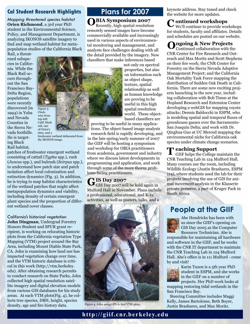
Cal Student Research HighlightsMapping threatened species habitatOrien Richmond, a 3rd year PhD student in the Environmental Science, Policy, and Management Department, is analyzing IKONOS satellite imagery to find and map wetland habitat for meta-population studies of the California Black Rail, a threat-ened subspe-cies in Califor-nia. While the Black Rail oc-curs through-out the San Francisco Bay-Delta Region, populations were recently discovered (in 1994) in Yuba and Nevada Counties in the Sierra Ne-vada foothills. He is target-ing Black Rail habitat, patches of freshwater emergent wetland consisting of cattail (Typha spp.), rush (Juncus spp.), and bulrush (Scirpus spp.), to understand how patch size and patch isolation affect local colonization and extinction dynamics (Fig. 3). In addition, he is trying to map habitat characteristics of the wetland patches that might affect metapopulation dynamics and viability, including density of certain emergent plant species and the proportion of differ-ent wetland cover classes.
California’s historical vegetationJohn Dingman, Undergrad Forestry Honors Student and SPUR grant re-cipient, is working on relocating historic plots from the California vegetation Type Mapping (VTM) project around the Bay Area, including Mount Diablo State Park, CA. John is examining how land use has impacted vegetation change over time, and the VTM historic database is criti-cal in this work (http://vtm.berkeley.edu). After obtaining research permits to conduct research on State Parks, John collected high spatial resolution satel-lite imagery and digital elevation models from various GIS databases for his study areas. At each VTM plots(Fig. 4), he col-lects tree species, DBH, height, species density, age and fire history data.
BIA Symposium 2007Recently, high spatial resolution
remotely sensed images have become commercially available and increasingly used in various aspects of environmen-tal monitoring and management, and analysts face challenges dealing with all the detail provided by the imagery. New classifiers that make inferences based
not only on spectral properties, but also on information such as object shape, texture, spatial relationship as well as human knowledge are proving to be useful in this high spatial resolution world. These object-based classifiers are
proving to be useful in many applica-tions. The object-based image analysis research field is rapidly developing, and
in the late spring/early summer of 2007 the GIIF will be hosting a symposium and workshop for OBIA practitioners from academia, government and industry where we discuss latest developments in programming and application, and work through some of the more thorny prob-lems facing practitioners.
IS Day 2007GIS Day 2007 will be held again in
Mulford Hall in November. Plans include a professional, educational, and K-12 activities, as well as posters, talks, and a
keynote address. Stay tuned and check the website for more updates.
ontinued workshopsWe’ll continue to provide workshops
for students, faculty and affiliates. Details and schedules are posted on our website.
ngoing & New ProjectsContinued collaboration with the
CNR Center for Fire Research and Out-reach and Max Moritz and Scott Stephens on their fire work; the CNR Center for Forestry on the Sierra Nevada Adaptive Management Project; and the California Oak Mortality Task Force mapping the distribution of Sudden Oak Death in Cali-fornia. There are some new exciting proj-ects launching in the new year, includ-ing collaboration with Bob Timm at the Hopland Research and Extension Center developing a webGIS for mapping coyote attacks; Dennis Baldocchi in ESPM, who is modeling spatial and temporal fluxes of greenhouse gasses over the Sacramento-San Joaquin Delta; and work with Dr. Qinghua Guo at UC Merced mapping the environmental niche for California oak species under climate change scenarios.
eaching SupportGIIF helps the College maintain the
CNR Teaching Lab in 124 Mulford Hall. Many courses use the room, including Wildlife Ecology (Justin Brashares, ESPM 114), where students used the lab for their projects involving the use of GIS for ani-mal movement analysis in the Klasserie private preserve, a part of Kruger Park in South Africa.
http:/ /gi i f .cnr.berkeley.edu
Figure 3. Clock-wise from top-left: Calif. black rail, one of Orien’s sites, and a freshwater wetland delineated from the IKONOS image.
Figure 4. John using GPS to find VTM plots.
OPlans for 2007
C
O
G
T