Embed Size (px)
Citation preview
This is a repository copy of GIS Application to Support Land Administration Services in Ghana: Institutional Factors and Software Developments.
White Rose Research Online URL for this paper:http://eprints.whiterose.ac.uk/5008/
Monograph:Karikari, I.B., Stillwell, J. and Carver, S. (2002) GIS Application to Support Land Administration Services in Ghana: Institutional Factors and Software Developments. Working Paper. School of Geography , University of Leeds.
School of Geography Working Paper 02/02
[email protected]://eprints.whiterose.ac.uk/
Reuse Unless indicated otherwise, fulltext items are protected by copyright with all rights reserved. The copyright exception in section 29 of the Copyright, Designs and Patents Act 1988 allows the making of a single copy solely for the purpose of non-commercial research or private study within the limits of fair dealing. The publisher or other rights-holder may allow further reproduction and re-use of this version - refer to the White Rose Research Online record for this item. Where records identify the publisher as the copyright holder, users can verify any specific terms of use on the publisher’s website.
Takedown If you consider content in White Rose Research Online to be in breach of UK law, please notify us by emailing [email protected] including the URL of the record and the reason for the withdrawal request.
WORKING PAPER 02/02
GIS Application to Support Land
Administration Services in Ghana:
Institutional Factors and
Software Developments
Isaac Bonsu Karikari,
John Stillwell
and Steve Carver
School of Geography
University Of Leeds
LS2 9JT
April 2002

ii
ABSTRACT
In June 1999, the Ghanaian Government launched a new land policy document that
sought to address some fundamental problems associated with land administration and
management in the country. The document identified the weak land administration
system as a particular problem and recommended the introduction of computer-aided
information systems in the �lands sector�. In 2001, the Government made further
proposals to prepare and implement a Land Administration Programme (LAP) to
provide a better platform for evolving an efficient land administration that would
translate the �National Land Policy� into action. Thus, an up-to-date land information
system (LIS), supporting efficient management of land records, is to be constructed,
which provides a context for the research reported in this paper.
We document two aspects of our research on the adoption of GIS by the Lands
Commission Secretariat (LCS) which form part of a pilot project in GIS diffusion.
Part one of the paper mainly outlines the empirical results arising from fieldwork
undertaken during 2001 to determine the information and GIS requirements of the
LCS in relation to their routine administrative processes and to identify the critical
factors that are required to ensure that any new GIS applications are successfully
embraced. Part two explains the prototype software system developed using ArcView
3.2 and Access that provides the LCS with a means to automate some of the routine
administrative tasks that they are required to fulfil. The software has been modified
and upgraded following an initial evaluation by LCS employees also conducted as
part of the fieldwork in Accra.
Keywords
Land administration; diffusion of geographic information systems; Ghana; Accra
Lands Commission Secretariat
iii
TABLE OF CONTENTS
Page
CONTENTS
ABSTRACT ii
LIST OF TABLES iv
LIST OF FIGURES iv
LIST OF BOXES v
LIST OF PLATES v
1 Introduction 1
2 GIS Diffusion 2
3 Land Administration in Ghana 4
3.1 Land Ownership 4
3.2 The Lands Commission Secretariat 6
3.3 Progress Towards GIS Adoption and Land Policy 7
4 GIS Implementation in the Accra LCS 10
4.1 Strategies and Methodologies for Data Collection 11
4.2 Questionnaire Surveys 12
4.3 Questionnaire Responses: Institutional Issues 14
4.4 Questionnaire Responses: Application Issues 17
5 Results from the Critical Success Factor (CSF) Methodology 20
5.1 Applying the Methodology 20
5.2 Critical Success Factors Identified 35
5.3 General Observations and Problems Encountered 37
5.4 Major Findings and Discussion 39
5.5 Implications for GIS Implementation in the Accra LCS 46
6 The LANDAMIN Prototype Software 49
6.1 Study of Search Process using the Data Flow Analysis Methodology 50
6.2 Design Issues 67
iv
6.3 The Architecture of the LANDAMIN Prototype Software 71
6.4 ArcView 3.2 User Interfaces 72
6.5 The Linked ArcView and Microsoft Access Interfaces 74
6.6 The Microsoft Access Interfaces 78
7 Respondents Reaction to Initial Prototype Software 80
8 Conclusions 83
References 86
Appendix 1: Scoring �Factors� 89
Appendix 2: Questionnaires for Key Decision Makers /Technical Staff (Part 1) 90
Appendix 3: Questionnaires for Key Decision Makers /Technical Staff (Part 2) 96
Appendix 4: The Prototype Users Evaluation Form 103
Appendix 5: Initial Features of the Prototype Software for Testing in the Accra LCS
(September 2001) � ArcView 3.2 Interface 110
Appendix 6: Summary of Individual Respondent�s Views on Software Applications
(September 2001) � ArcView 3.2 Interface 111
LIST OF TABLES
1. Use of selected software packages by respondents (September 2001) 17
2. �Factors� emerging out of brainstorming sessions and their initial scores 25
3. Reviewed �Factors� and their prioritisation by respondents 31
4. Sample data set in ArcView 3.2 71
5. Sample data set in Microsoft Access 72
6. Overview schema of the menu structure in ArcView 3.2 (Project window) 73
LIST OF FIGURES
1. The Critical Success Factor (CSF) pilot study 22
2. Juxtaposing �Activities� and �Factors� (The CSF matrix before validation) 27
3. The data flow analysis (DFA) and prototype design pilot study 51
4. The data flow diagram - �Context� 53
5. The data flow diagram � �Top Level (The Searches process) 55
6. The data flow diagram � �Level One (Current Searches process) 57
v
7. The data flow diagram � Level One (Future Situation) 64
8. Detailed architecture of the LCS prototype software (LANDADMIN) 69
9. Site plans selection via themes 74
10. Site plans selection via input of plot number 74
11. Linking ArcView to Microsoft Access 75
12. Microsoft Access � meta data structure 77
13. Lessees general information on Achimota Residential Area 78
14. Attribute information as part of search report 79
15. Link to the Internet from Access to the Ghana home page 80
LIST OF BOXES
1. Storage is a problem in the Accra LCS
2. Why the CSF was chosen 23
3. Data dictionary for �Processes� (Searches) 58
4. Data dictionary for �Flows� (Searches) 59
5. Data dictionary for �Stores� (Searches) 60
LIST OF PLATES
1. Registers (showing how information is presently stored ) 7
2. Participants to the fieldwork exercise (August � September 2001) 10
3. Plotting at the Greater Accra Region Records Office (GARRO) 13
4. Brainstorming session during fieldwork (September 2001) 19
5. Validation session (September 2001) 21
6. Review with top management 32
7. Legacy left by GERMP 33
8. Sorting at the Search Office (September 2001) 54
9. Legacy left by GERMP (equipment heavily underutilised) 67
10. Testing LANDADMIN (ArcView 3.2 Interfaces) 81
1
GIS Application to Support Land Administration Services in Ghana:
Institutional Factors and Software Developments
PART ONE
1 Introduction
In Ghana, as elsewhere in the world, land is a unique resource of fixed location,
incapable of expansion in supply (except in cases where, marginal increases have
been made through reclamation). The necessity for efficient and effective
management of this limited resource is of paramount importance. Both land
administration and management involve land registration and it has been recognised
that improvements to land registration systems and the establishment of land
information systems (LIS) or geographic information systems (GIS) are important
catalysts for development in less developed countries. This position is recognised by
the Global Strategy for Shelter for the Year 2000 (UNCHS, 1990) that recommends
the establishment of efficient land registration and GIS as a priority area of national
policy action for all countries.
In this paper, we are concerned with the diffusion of GIS into organisations in a less
developed country. Our attention is focused on both institutional factors and technical
developments, recognising that the transfer of innovations (diffusion) is a difficult and
complex process, only likely to succeed if it becomes a part of the daily lives of the
organisation(s) involved. Carter (1989) defines GIS as an �institutional entity
reflecting an organisational structure that integrates technology with a database,
expertise and continuing financial support over time�. This view is shared by Chan
and Williamson (1999) who suggest the elements of this perception should include
data, information technology, standards, people with GIS expertise and the
organisational setting. The research in this paper adopts Carter�s definition as being
relevant to the land sector in general and to the Accra Lands Commission Secretariat
(LCS) in particular. The paper assumes �land administration� to be the process
whereby land, and information about land, may be effectively managed. Land
administration therefore includes identifying those people who have interest in real
estate and information about those interests such as the nature and duration of rights
to land. It also includes information about each land parcel such as its location, size,
2
improvements, ownership and value. The term land administration is restricted here to
ownership means and land taxation and does not include the wider issues involved in
optimising the use of land as a resource (UNCHS, 1990). This distinguishes �land
administration� from �land management� which is the process of managing the use
and development of land resources in a sustainable way.
The paper highlights some of the characteristics of Ghana�s lands sector from the
perspective of the Accra Lands Commission Secretariat (LCS), the agency
responsible for the administration of public lands in Accra (Section 3). Thereafter, we
report the results of using a suite of methodologies to identify the information
requirements of the Lands Commission Secretariat (LCS) for GIS use (Section 4) and
the factors that are deemed to be critical in successful implementation (Section 5).
Section 6 outlines the technical development of a customised administrative support
system called �LandAdmin� that has been designed to automate several of the routine
land administrative tasks that the LCS is required to undertake on a routine basis. The
prototype software, which has a number of selected features, has been demonstrated
in the LCS as part of the strategy of gaining acceptability prior to adoption. We report
on the initial evaluation of the prototype by LCS employees (Section 7) and show
how modifications and extensions have been incorporated. However, before the
results of the fieldwork relating to the institutional context and the prototype software
are discussed in detail, we provide a broader perspective by reviewing the extant
literature on GIS diffusion.
2 GIS Diffusion
Like the definition of the term GIS itself, the word diffusion has various meanings.
Zeltman et al. (1973) define it as the process of communicating a novelty to and
among the population of potential users who might choose to adopt or reject it.
Campbell and Masser (1995) suggest that it refers to �the fundamental process that is
responsible for the transfer of innovations from the workshops of their inventors to
becoming a daily part of the lives of a large section of society� (Campbell and
Masser, 1995: 4). Alternatively, Rogers defines diffusion as �the process by which an
innovation is communicated through certain channels over time among members of a
social system. It is a special type of communication, in that the messages are
concerned with new ideas� (Rogers, 1983: 5). The review of Rogers� work by
3
Onsrud and Pinto (1991) helps to provide an understanding of the factors and
processes underpinning adoption, implementation and utilisation of geographic
information technologies. These indicate that innovation, communication, adoption
over time and the social system are the four main elements in the diffusion process;
and that innovation is an idea, practice or object perceived as new by an individual,
group or organisation. For technological innovation to diffuse faster, it must a have a
low degree of complexity, a high degree of �trialability� before commitment, a high
degree of visibility to other potential adopters, a high degree of compatibility with
existing values, past experiences and needs of potential adopters, and finally have
relative advantage over the methods it supplants (Rogers, 1983)
Eason (1988) has indicated that the sequence of stages � what he terms the traditional
data process approach � in implementing GIS in organisations represents a �linear
view of diffusion�. These stages include project selection, a feasibility study through
trials (prototyping) and implementation. Campbell and Masser (1995) acknowledge
that this may define implementation narrowly as users have not been fully involved.
Eason (1988) had accepted this, criticising the attempt to merely involve users as they
have not really been practically involved, �especially as there is limited time that is
often available for users to assimilate and contribute to the complex and highly
technical documentation with which they are confronted� (Campbell and Masser,
1995). There is, therefore, a need to gain organisational and user acceptance of the
technology, placing emphasis on participative approaches to implementation
characterised by user-centred design values. According to Eason, such a philosophy
starts with the supposition that it is the organisational rather than technological issues
that are most likely to endanger the effective implementation of computer-based
systems. He accepts that such a philosophy does not deny the technological
component of such systems, even though, placing too much emphasis on this element
may be counter-productive. Campbell and Masser (1995) insist that user involvement
must not be restricted to symbolic consultations. Users ought to be given enough time
and skill �that they have real ownership of the project�.
Zwart (1990) notes that whilst computerisation may be necessary, most countries are
well advised to carry out a review of their current information practices. They need to
examine existing practices on such issues as their data recording, data maintenance
4
and data quality procedures. These activities do not rely on investments in high cost
technology, but mainly require an investment in people as individuals and in
organisations. �The time to decide as to whether to use computer-based schemes is
when these organisations and management reforms are in place. They need not, and
in most cases should not, go hand in hand as the common wisdom seems to suggest. In
the meanwhile, by reforming your existing Land Information Management system
before introducing the computer, you will have taken the major step to secure their
success. You will also have minimised the risks and gained most of the benefits�
(Zwart, 1990). Keen (1981) has noted some interesting reactions by users to the
implementation of computer-based systems. He notes that these include exploiting the
system designers� lack of knowledge about the organisational environment and
therefore ensuring that the project ultimately does not succeed; undermining key
individuals in the project so that their trustworthiness is lost; and lying low so as to
avoid direct confrontation and thereby not fully playing a part in the project!
Finally, it is apparent that much of the reported research on GIS diffusion in the
developing world has either been �anecdotally based� (research not conducted under
controlled conditions) or focused on retrospective single case studies of successful
implementations. There is little evidence to show the use of empirical methods in a
more organised study of GIS/LIS diffusion in developing countries. Much could be
learned from prospective studies as new classes of users learn about the possible
application of the new geotechnology tools to their fields. Thus, we conclude that in
evaluating the transfer of geographic information innovations, it is essential to take
into consideration the full process of adoption (Onsrud and Pinto, 1991).
3 Land Administration in Ghana
3.1 Land Ownership
Land administration in Ghana is complicated because of the existing land ownership
arrangements. In broad terms, the country has a land ownership system in which
customary tenures are distinguished from state land. Customary tenures comprise
�absolute interests� held by two main types of the land-owning community and may
occur through discovery of land or through conquest/war. The lands that are held by
these land-owning communities are termed �stool/skin� and �family� lands. The head
of a stool or skin (the latter term used in the northern part of the country) holds these

5
lands in trust for the subjects of the stool in accordance with customary law and
usage. The stool or skin symbolises the authority of heads of these traditional states
who are vested with managerial functions of the lands under their control. Members
of these two land owning groups who are subjects of stool/skin or family lands also
have �usufructuary rights� - rights to use or dispose of use-rights over land, including
the right to occupy, till or otherwise enjoy any �unappropriated� portion of the stool or
skin land. There are also �private lands� that emerge out of such transactions.
The second main type of land in Ghana is state or public land. Under Act 123, the
Administration of Lands Act, 1962, the Government was able to vest stool/skin lands
in the President by �executive instrument� in what comes about as �split ownership�.
In this case, the Ghanaian Government manages the land and collects rent on behalf
of the customary landowner who retains the beneficiary or equitable rights in the land
rents emanating therefrom. On the other hand, through the exercise of the powers of
eminent domain (compulsory acquisition of land), the Government could also acquire
land, subject to the payment of compensation. This is provided under the 1992
Constitution through its enabling Act, Act 125 � the State Lands Act, 1962.
It has been the case in Ghana that obstacles arising out of inappropriate land tenure in
some areas, and poor land utilisation procedures in the country as a whole have
prevented investment in both agriculture and industry. This is one of the reasons why
there is a growing need for a better land administration and management throughout
the country. Other problems include that of land encroachments and multiple sales of
land that have led to environmental problems, disputes, conflicts and endless
litigation. Encroachments on public lands appear to engage the serious attention of
government. These encroachments sometimes involve building on lands without
regard to planning schemes prepared by government for such areas. In the Greater
Accra Region alone, almost all sites earmarked for various activities have been taken
over by the �encroachers�. The site for the Council for Scientific and Industrial
Research (CSIR) to serve as a scientific instrumentation centre at Otinshie-Accra has
been affected by encroachment, forcing government to release a vast portion of the
land back to the owners. The status of these owners, like many others, cannot be
readily ascertained due to conflicting claims that have to be eventually settled in the
courts. Other sites extensively encroached upon include the site for the National
6
Sports Complex at Achimota, the site for Police Depot and College at Ofankor. The
residential and industrial sites at Ofankor and the site for Ambassadorial Enclave at
East Legon have all also been heavily affected.
�There are indeterminate boundaries resulting directly from lack of reliable
maps/plans and the use of unapproved, old or inaccurate maps�. This has led to land
conflicts and litigation between stools, skins and other land owning groups. The
government has not utilised large tracts of land acquired compulsorily neither has
compensation been paid for most of the acquired lands. Landowners have been left
�landless� having been denied their source of livelihood.
The lack of adequate functional and co-ordinated geographic information systems and
networks as well as of transparent guidelines have been identified as one of the
problems to be tackled. This requires that the land agencies �maintain up to date
scientific data, maps and plans; geographic database and information systems�.
3.2 The Lands Commission Secretariat
The Lands Commission is a public institution set up under the Lands Commission Act
of 1994 (Act 483) in accordance with Article 258 of the 1992 Constitution of Ghana.
It is mainly charged with the responsibility of managing public lands and any lands
vested in the President of the Republic. It has a Secretariat, the Lands Commission
Secretariat (LCS) that carries out its functions. It is both a provider and user of
geographic information. The current information system for the LCS comprises a
complex set of requirements with the primary purpose of using geographic
information related to creating and maintaining an inventory of land data. The LCS is
expected to respond to a government mandate to manage public land in the most
effective and efficient manner possible and to advise the Government on land use
change and capability. This involves identifying land problems, determining strategies
for land reform, monitoring land use change on public land, developing alternative
plans and finding solutions to a myriad of land problems, including encroachments on
public land.
The LCS uses various themes that may include land use on land parcels as geographic
units. The output of the current system of administration is primarily maps at various
7
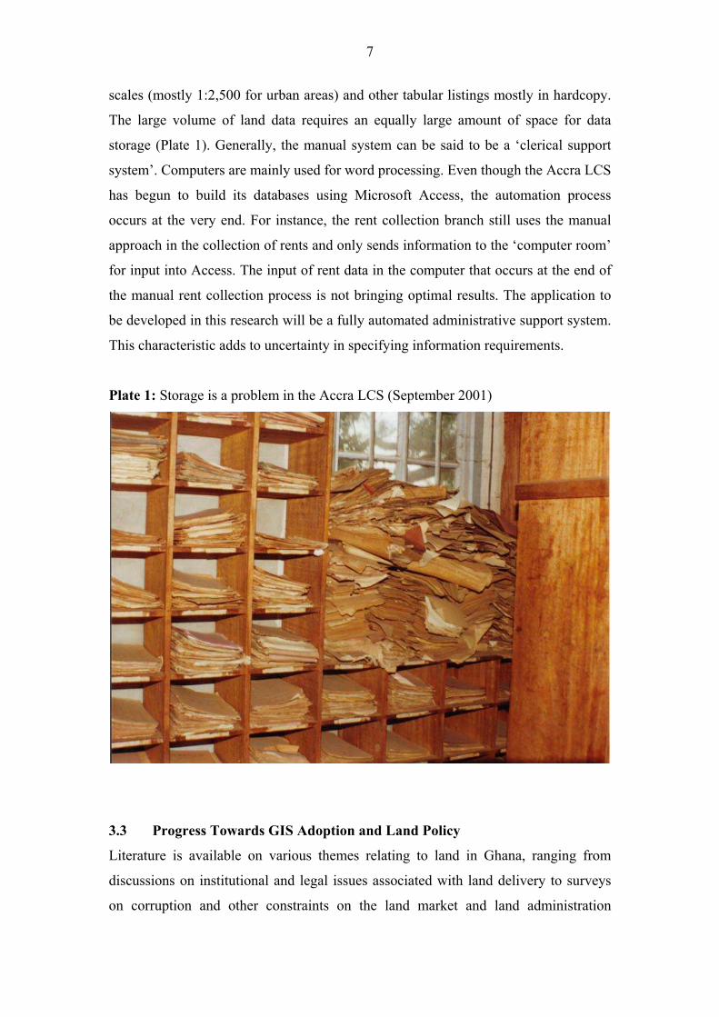
scales (mostly 1:2,500 for urban areas) and other tabular listings mostly in hardcopy.
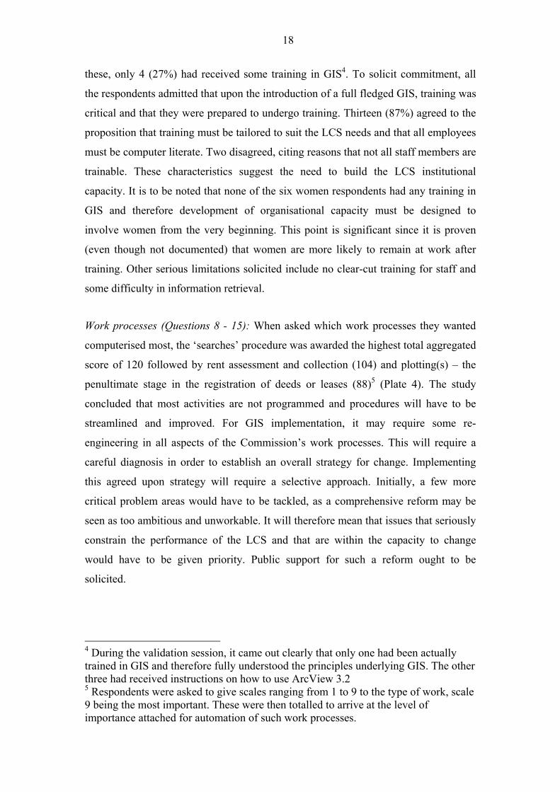
The large volume of land data requires an equally large amount of space for data
storage (Plate 1). Generally, the manual system can be said to be a �clerical support
system�. Computers are mainly used for word processing. Even though the Accra LCS
has begun to build its databases using Microsoft Access, the automation process
occurs at the very end. For instance, the rent collection branch still uses the manual
approach in the collection of rents and only sends information to the �computer room�
for input into Access. The input of rent data in the computer that occurs at the end of
the manual rent collection process is not bringing optimal results. The application to
be developed in this research will be a fully automated administrative support system.
This characteristic adds to uncertainty in specifying information requirements.
Plate 1: Storage is a problem in the Accra LCS (September 2001)
3.3 Progress Towards GIS Adoption and Land Policy
Literature is available on various themes relating to land in Ghana, ranging from
discussions on institutional and legal issues associated with land delivery to surveys
on corruption and other constraints on the land market and land administration
8
(Ollennu, 1962; Acquaye and Associates, 1989; Brobby, 1991; 1992; Kasanga, 1990;
Kasanga et al., 1996; Larbi, 1995; 1996; CDD, 2000; Somevi, 2001). Almost all of
these studies with the exception of CDD (2000) and Somevi (2001) have failed to
recommend the need to use computers or capture, analyse and disseminate land-
related information using GIS capabilities. However, there are some discussions
(Mills et al, 1997; http://glacier.gg.rhbnc.ac.uk/kumasi/Inception/inception.html;
GERMP, 1999) of projects with GIS components such as KUMINFO and GERMP
that were initiated by the international donor community and that related to the wider
issues involved in optimising the use of land as a resource in Ghana.
�KUMINFO�, for instance, is the GIS component of the Ghana�s Natural Resource
Management Project aimed at addressing critical issues on environmental conditions
confronting inhabitants of peri-urban Kumasi in Ghana. It is based on a pre-project
prototype, �PUDSI� an acronym for Peri-Urban Demonstrator for Spatial Integration
with programmed interfaces that is based on ArcView 3.2 and allows the display,
querying and analysing of spatial and non-spatial data for Kumasi. It also allows easy
access to research topics. The system runs in Kumasi within the Institute of
Renewable Natural Resources (IRNR), a constituent unit within the University of
Science and Technology (UST), Kumasi with parallel systems at the Natural
Resources Institute, University of Greenwich and the Royal Holloway College,
University of London. Reports indicate that the �lack of clearly pre-defined user-needs
and requirements, and the lack of available data for Kumasi limited the development
of PUDSI�.
In 1991, the Government approved the Ghana Environmental Resource Management
Project (GERMP) that aimed to implement the National Environmental Action Plan
(NEAP) under the co-ordinating role of the Environmental Protection Agency (EPA).
The Lands Commission, together with the Land Administration Research Centre
(LARC) of the University of Science and Technology (UST) Kumasi, were
responsible for the land ownership aspects under the Land and Water Management
Component of the project, under which the LCS inherited some GIS equipment that is
still available for use. Thus, although the KUMINFO and GERMP projects have not
focused on the lands sector directly, agencies such as the LCS have been involved
because of the land ownership and mapping issues that have arisen in these projects.
Despite the existence of the GERMP project, progress towards automation has
9
remained very slow in Ghana�s lands sector agencies. This can be attributed to
inherent difficulties with the technology itself and with problems of data conversion
that confront organisations in this sector. Even though the Survey Department under
GERMP used computers to perform land survey computations, the implementation of
GIS has proved difficult. The awareness of the potential of this technology appears to
be growing yet the technical, economic and institutional problems are yet to be
addressed in practice.
In 1999, the Government of Ghana initiated a �Land Policy Document� aimed, among
other things, at establishing and developing a land information system (LIS) and
networks between related agencies. It was noted that the basis for better management
of information, and for considerable improvement of information within the lands
sector might be brought about by evaluating and appraising existing tasks, discarding
unnecessary procedures and developing a better use of resources (UNCHS, 1990).
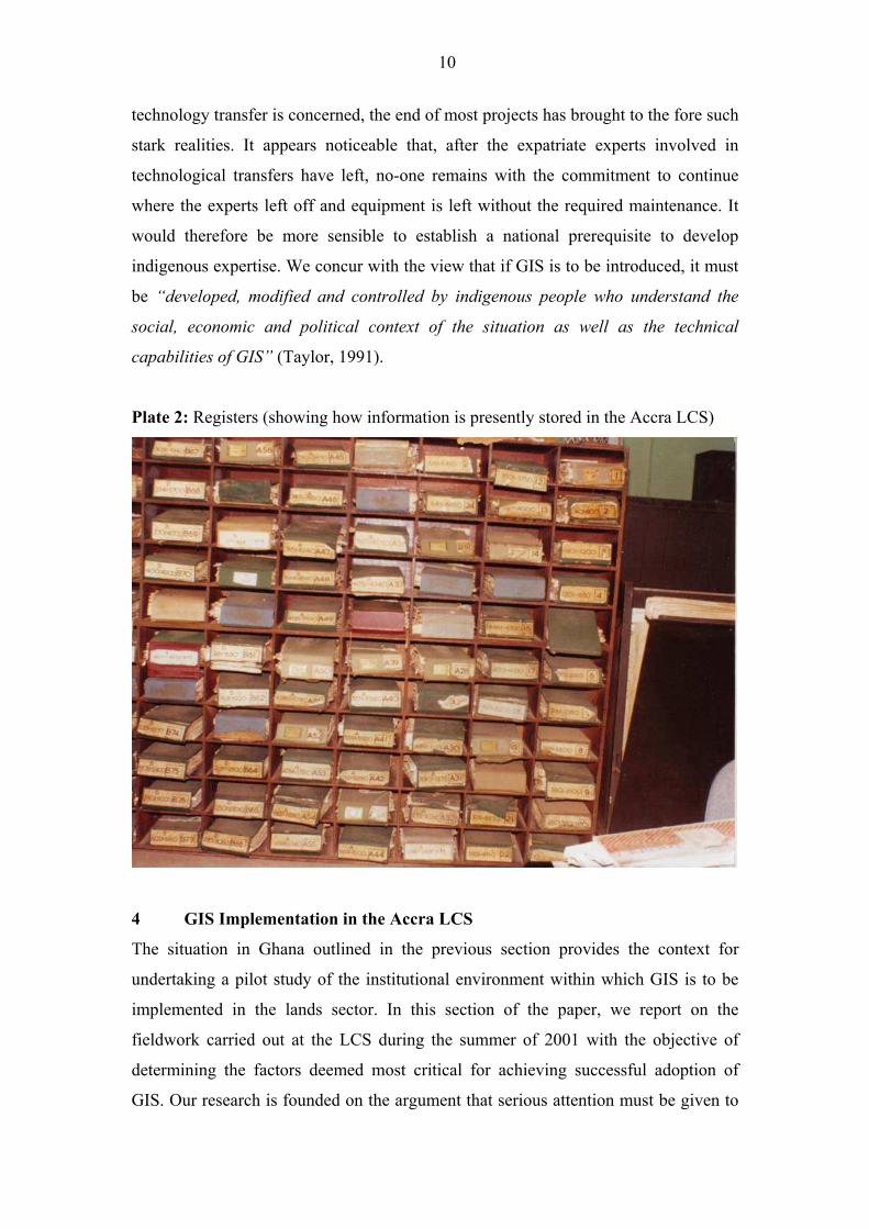
One of the main objectives has been to lessen duplication in the storage of
information and to restore registers physically damaged through handling (Plate 2)
with electronic versions. In 2001, the Government made proposals to prepare and
implement a Land Administration Programme (LAP) to provide a better stage for
evolving an effective and efficient land administration that would translate, within a
holistic environment, the National Land Policy into action. The proposed project is
consistent with the World Bank�s Country Assistance Strategy of March 2000 for
Ghana.
Thus, whilst there have been attempts to apply GIS in Ghana, several of which have
had implications for the lands sector, there has been no attempt to address the specific
issue of using GIS to support the administration of land in the country. One of the
dangers in this context is that GIS technologies may be adopted without critical
analysis and without consideration of the socio-economic and institutional
background of the land agencies concerned and without the need to involve the
indigenous experts from the very outset. It is our view that whilst some financial and
technical support for successful GIS diffusion in the lands sector is required,
governments in countries such as Ghana must now claim and expect to receive more
control over project design and execution. In most cases (as seen with the GERMP
project), while the role of expatriates was significant in the beginning insofar as
10
technology transfer is concerned, the end of most projects has brought to the fore such
stark realities. It appears noticeable that, after the expatriate experts involved in
technological transfers have left, no-one remains with the commitment to continue
where the experts left off and equipment is left without the required maintenance. It
would therefore be more sensible to establish a national prerequisite to develop
indigenous expertise. We concur with the view that if GIS is to be introduced, it must
be �developed, modified and controlled by indigenous people who understand the
social, economic and political context of the situation as well as the technical
capabilities of GIS� (Taylor, 1991).
Plate 2: Registers (showing how information is presently stored in the Accra LCS)
4 GIS Implementation in the Accra LCS
The situation in Ghana outlined in the previous section provides the context for
undertaking a pilot study of the institutional environment within which GIS is to be
implemented in the lands sector. In this section of the paper, we report on the
fieldwork carried out at the LCS during the summer of 2001 with the objective of
determining the factors deemed most critical for achieving successful adoption of
GIS. Our research is founded on the argument that serious attention must be given to
11
institutional processes of GIS adoption and use even though technical issues relating
to the development of the software system are also essential. One of the primary
objectives has been to identify the range of factors relevant to GIS diffusion in the
Accra LCS through empirical study. The ethnic background of Isaac Bonsu Karikari
as a Ghanaian who has been involved in land administration for well over twelve
years, at which period he headed three of Ghana�s ten regions as Regional Lands
Officer, the last being the Greater Accra Regional office of the LCS, was particularly
necessary in gaining the support of the organisation and the willingness of the
workforce to collaborate in the pilot project.
4.1 Strategies and Methodologies for Data Collection
It was necessary to develop a strategy for data collection and analysis in order to
achieve the objectives of:
• understanding the organisational issues confronting the LCS that might
impact on GIS adoption ;
• determining the factors that are critical for the successful implementation
of GIS; and
• identifying the functional needs of the LCS in relation to GIS
In order to achieve the first of these objectives and establish the organisational
context, we adopted the approach of asking (through questionnaires) a selection of
senior managers and technical staff to give independent opinions about the various
characteristics of the LCS, the results of which are presented in Section 4.3. Similarly,
questionnaires were used to obtain information from respondents to fulfil the third
objective and to establish the (functional) needs of the LCS with respect to GIS
(Section 4.4). Brainstorming sessions were carried out and the critical success factor
(CSF) methodology was used to achieve the second objective of prioritising those
factors deemed by respondents to be the key factors for successful GIS
implementation. We report on the results of the application in section 5. In section 6,
we present a prototype application of GIS to support various administrative services.
A methodology known as data flow analysis (DFA) was used to identify the software
requirements and the results of the DFA are also reported in this section.
Respondents� reactions to the prototype software were obtained by using an
evaluation questionnaire, the results of which are shown in section 7.
12
4.2 Questionnaire Surveys
The questionnaire for eliciting organisational requirements was designed to
determine the characteristics of the Accra LCS and covered issues such as wage
levels, inter-personal and individual behaviour, conflicts, management style, authority
definition and hierarchy et cetera. Overall eighteen questions were posed. Appendix 2
details the structure and results obtained from the questionnaire. With the application
level questionnaires, the aim was to determine the application requirements such as
users competence with selected and widely used software such as Word and GIS tools
such as ArcView, training needs, storage space, data needs etceteras. Twenty-three
such questions were asked. Appendix 3 details the structure and results obtained at
this level.
These questionnaires were administered to two types of respondents, namely 15
respondents at the middle or line management level and five respondents at the top
management or policy level. The evaluation of responses to questionnaires by top
management was delayed until initial requirements from the middle level had been
obtained1. It is these initial requirements that are evaluated to determine the
characteristics of the LCS. Both open and closed questions were used in combination
for eliciting staff responses. The use of open questions safeguards against interview
prejudices that would have been achieved if only closed questions were used. To
minimise errors of interpretation, the responses to open questions were condensed in
the questionnaire (Flynn and Warhurst, 1994).
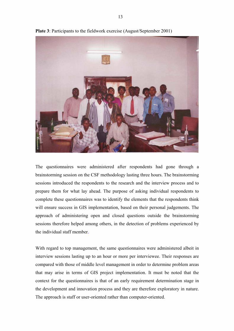
Nine males and six females (of the middle level) fully participated in the fieldwork
exercise. The mean number of years� experience for the middle level management is 9
per person, with values ranging from 2 to 29 years� experience on the job. The job
titles of the respondents included: Senior Lands Officer (1); Lands Officer (2);
Assistant Lands Officer (7); Principal Inspector of Lands (3); Assistant Chief
Technical Officer (1); and Senior Technical Officer (1). The respondents are an
appropriate representation of the LCS workforce and include all types of staff who
will be involved in GIS implementation (Plate 3).
1 Reasons for this are given at 5.7 (implications for GIS)
13
Plate 3: Participants to the fieldwork exercise (August/September 2001)
The questionnaires were administered after respondents had gone through a
brainstorming session on the CSF methodology lasting three hours. The brainstorming
sessions introduced the respondents to the research and the interview process and to
prepare them for what lay ahead. The purpose of asking individual respondents to
complete these questionnaires was to identify the elements that the respondents think
will ensure success in GIS implementation, based on their personal judgements. The
approach of administering open and closed questions outside the brainstorming
sessions therefore helped among others, in the detection of problems experienced by
the individual staff member.
With regard to top management, the same questionnaires were administered albeit in
interview sessions lasting up to an hour or more per interviewee. Their responses are
compared with those of middle level management in order to determine problem areas
that may arise in terms of GIS project implementation. It must be noted that the
context for the questionnaires is that of an early requirement determination stage in
the development and innovation process and they are therefore exploratory in nature.
The approach is staff or user-oriented rather than computer-oriented.
14
4.3 Questionnaire Responses: Institutional Issues
Creating Awareness (Questions 1 � 3) The initial part of the questionnaire on
organisational issues was so designed as to create awareness among staff members in
positions to influence the attainment of the project�s objectives. Before the general
characteristics of the Accra LCS was determined, and as part of an attempt to create
awareness on GIS implementation, therefore, the fifteen respondents were asked three
questions that required their acceptance of the goal set by the Commission in GIS use.
They were also made aware of the crucial role GIS could play in the LCS whilst an
attempt was made to let them come to terms to the fact that the introduction of a full-
fledged GIS project may warrant a different way of doing things. It was necessary for
this to be done by staff members since there was the need for ensuring continuing
active support and interest. There was also the need to ensure internal consensus as
early as possible so that the machinery to maintain the GIS project could be
established. All respondents agreed with goal of �introducing a GIS that will support
land management applications leading within five years to increased revenue base,
efficiency and timely processes and high customer confidence in the Accra LCS work
processes�2.
Nature of the LCS (Questions 8 � 14, 17 and 18): Other questions were designed to
determine the organisational set up of the LCS and other institutional problems or
bottlenecks such as personal behaviour and their impact on the image of the Lands
Commission. Of the 15 respondents, 10 (67%) thought the LCS was overstaffed; three
(20%) disagreed. The ten who agreed were of the opinion that excess workers in the
LCS have led to underemployment and minimal workloads. However, almost all
respondents (14 respondents representing 93%) agreed that wage levels were low and
that levels must relate to productivity. Twelve (80%) of the respondents saw conflicts
existing between the Estates Section of the Commission and the Legal Section with
10 (67%) citing a conflict situation existing between the Estates section and the
Accounts section. When asked further to determine where the conflict emanated from,
five respondents (33%) attributed it to leadership style and roles only, whilst three
(20%) related it to work processes (only) and three respondents to policy issues
(only). It would appear that improved pay and incentives and greater opportunities for
2 This was adapted from the Lands Commission Mission Statement of 2001
15
promotion have a strong part to play in the bid to introduce a full-fledged GIS into the
Accra LCS. The study also points to the fact that the LCS is badly in need of some
streamlining of its structures and processes or even some overhaul. The GIS project
has to take into account the potential impact of these factors, anticipate these
problems and modify the implementation path accordingly.
Management style (Questions 15): Management style appears to have been
detrimental over the years, as there have been few consultations between the
implementation of different programmes. Changes in user personnel (as happened in
20003) may create unstable user patterns (Davies, 1983). On management style, nine
respondents (60%) thought that leadership style for the last 10 years had been
autocratic whilst two respondents (13%) thought it had been paternalistic. Only one
thought it had been consultative; three did not respond. Whilst respondents attributed
this to lack of managerial talent, most felt that political interference was also to blame.
Discontinuity of management as a result of frequent changes for political reasons is
deemed highly disruptive. The GIS project characterised by a positive commitment on
the part of management and politicians will be crucial for its success in the Accra
LCS.
Authority definition/hierarchy and degree of decentralisation of operations
(Questions 15 and 16): Eleven respondents (73%) saw authority definition and
hierarchy as unclear. Only three (20%) insisted that it was clear; and one did not
respond. Our investigations reveal that a Deputy Executive Secretary has never been
appointed even though this was a Constitutional requirement. If the Executive
Secretary was indisposed, who acts? We concluded that the LCS would have to be
strengthened at different hierarchical levels and in various aspects relating to
management, planning and policy formulation. A GIS project with a clear and well-
defined institutional environment coupled with the right managerial arrangements and
attitudes will greatly enhanced prospects for success. This point brought to the fore an
3In the year 2000, the new Executive Secretary supervised the �exchange� of over 20
clerical staff members who had worked with the LCS for 10 years or more to other
government institutions for what as unofficially attributed to corrupt practices on the
part of such staff. One year ahead, the present crop of clerical staff is being accused of
the same thing!
16
investigation into the degree of decentralisation now existing. Fourteen respondents
(93%) believe that the Accra LCS must have a role distinct from the Head Office as
envisaged by the Lands Commission Act, Act 483. The lack of this clear role re-
enforced the respondents� earlier view that the definitions of authority and hierarchy
in the LCS were unclear.
Political interference in the work of the LCS (Questions 4 - 7): Our investigations
also revealed that there is the lack of stability in the structure of the organisation due
to Government�s interventions, particularly in the appointment and removal of �top
brass� in the LCS. The perceived political pressure on the LCS from the Ministry of
Lands and Forestry was therefore investigated. Three (20%) respondents deemed such
interference as positive, four (27%) saw it as negative with six (40%) being uncertain.
However, 11 respondents (73%) were emphatic in agreeing to the proposition that the
LCS must receive autonomy and be insulated from government control, whose role
must be catalytic only. Nine respondents (60%) agreed that all directions from
Government must be rooted through the National Lands Commission with three
(20%) disagreeing; two were unsure. A general conclusion may be drawn, as has
already been indicated, that the GIS project in the LCS will require strong and
sustained Government support if the project�s objectives are to be achieved. This is a
complex matter that ought to be handled and monitored carefully by the GIS project
manager. Government support in the allocation of human and financial resources or
through the workings of the administrative and political apparatus will be critical to
the Accra LCS GIS project�s success.
As the empirical study shows, with management control changing, uncertainty is high
and therefore this factor �adds� to the level of uncertainty when introducing GIS.
Because uncertainties are generally high, this suggests the need for the LCS to begin
with a small pilot project preceded by a selected features prototype software that is
deliberately experimental in nature and that needs to be monitored closely for
eventual adoption. The next part of this paper will examine questionnaires
administered at the application level before discussions on the use of the CSF
methodology which seeks to establish which prioritised factors and their associated
activities are critical for GIS diffusion and implementation in the Accra LCS are
made.
17
4.4 Questionnaire Responses: Application Issues
In terms of the technical process of land administration, there is an initial need to
study critically the needs of the agencies involved in land administration, management
and planning. This will help to bridge the gaps in conceptual understanding between
the potential GIS users (staff in the LCS and other land agencies) and the GIS
developer. The design of information systems in this research depends not only on the
development of concepts of performance (organisational issues) and but also the
functional needs (application issues) for these land agencies. This part of the paper
reports the results obtained from the questionnaire on application issues.
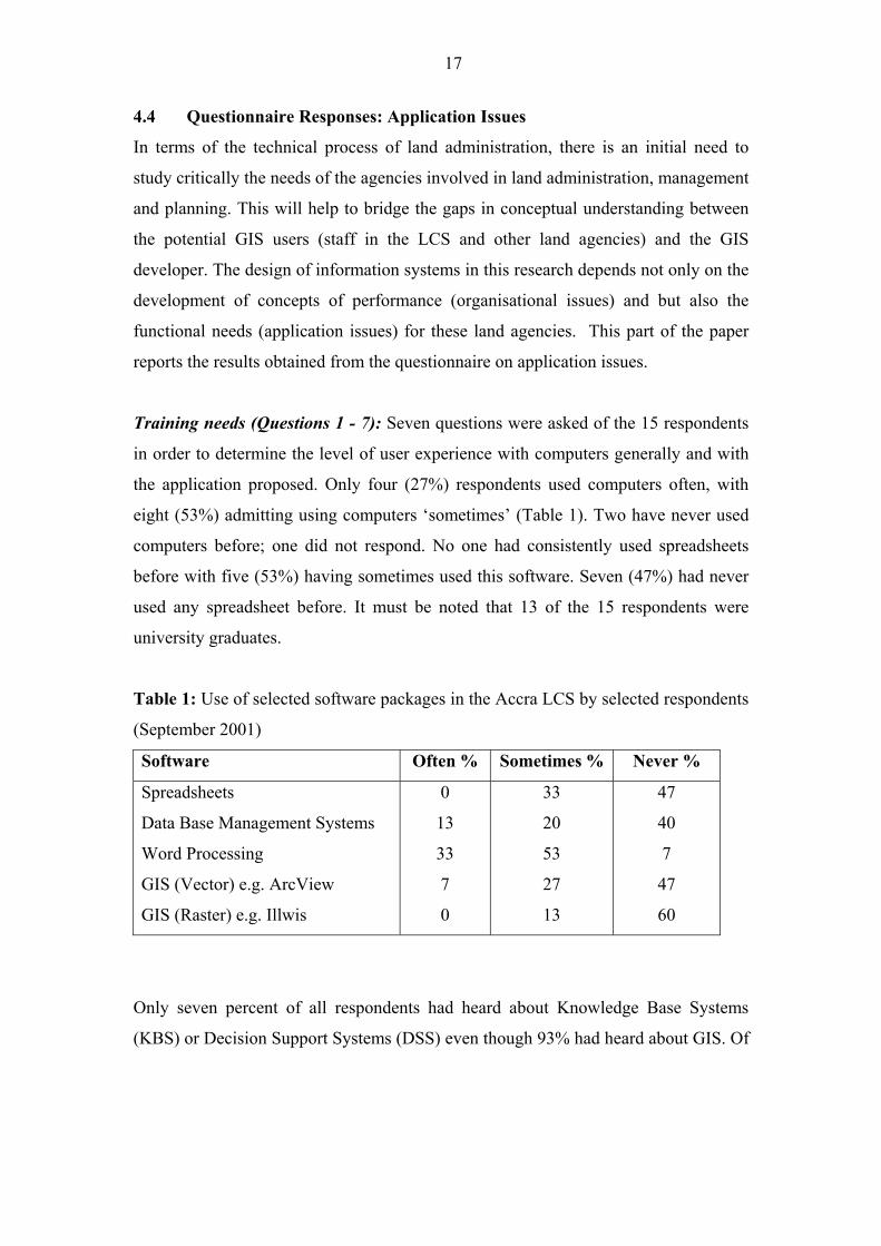
Training needs (Questions 1 - 7): Seven questions were asked of the 15 respondents
in order to determine the level of user experience with computers generally and with
the application proposed. Only four (27%) respondents used computers often, with
eight (53%) admitting using computers �sometimes� (Table 1). Two have never used
computers before; one did not respond. No one had consistently used spreadsheets
before with five (53%) having sometimes used this software. Seven (47%) had never
used any spreadsheet before. It must be noted that 13 of the 15 respondents were
university graduates.
Table 1: Use of selected software packages in the Accra LCS by selected respondents
(September 2001)
Software Often % Sometimes % Never %
Spreadsheets
Data Base Management Systems
Word Processing
GIS (Vector) e.g. ArcView
GIS (Raster) e.g. Illwis
0
13
33
7
0
33
20
53
27
13
47
40
7
47
60
Only seven percent of all respondents had heard about Knowledge Base Systems
(KBS) or Decision Support Systems (DSS) even though 93% had heard about GIS. Of
18
these, only 4 (27%) had received some training in GIS4. To solicit commitment, all
the respondents admitted that upon the introduction of a full fledged GIS, training was
critical and that they were prepared to undergo training. Thirteen (87%) agreed to the
proposition that training must be tailored to suit the LCS needs and that all employees
must be computer literate. Two disagreed, citing reasons that not all staff members are
trainable. These characteristics suggest the need to build the LCS institutional
capacity. It is to be noted that none of the six women respondents had any training in
GIS and therefore development of organisational capacity must be designed to
involve women from the very beginning. This point is significant since it is proven
(even though not documented) that women are more likely to remain at work after
training. Other serious limitations solicited include no clear-cut training for staff and
some difficulty in information retrieval.
Work processes (Questions 8 - 15): When asked which work processes they wanted
computerised most, the �searches� procedure was awarded the highest total aggregated
score of 120 followed by rent assessment and collection (104) and plotting(s) � the
penultimate stage in the registration of deeds or leases (88)5 (Plate 4). The study
concluded that most activities are not programmed and procedures will have to be
streamlined and improved. For GIS implementation, it may require some re-
engineering in all aspects of the Commission�s work processes. This will require a
careful diagnosis in order to establish an overall strategy for change. Implementing
this agreed upon strategy will require a selective approach. Initially, a few more
critical problem areas would have to be tackled, as a comprehensive reform may be
seen as too ambitious and unworkable. It will therefore mean that issues that seriously
constrain the performance of the LCS and that are within the capacity to change
would have to be given priority. Public support for such a reform ought to be
solicited.
4 During the validation session, it came out clearly that only one had been actually
trained in GIS and therefore fully understood the principles underlying GIS. The other
three had received instructions on how to use ArcView 3.2 5 Respondents were asked to give scales ranging from 1 to 9 to the type of work, scale
9 being the most important. These were then totalled to arrive at the level of
importance attached for automation of such work processes.
19
Information needs (Questions 18 -17): All respondents agreed to the proposition that
information/data the LCS provides or uses must be seen as a corporate resource; 27%
suggested that this information should be subsidised with 20% advocating for its free
use; and 53% felt that it should be at market value. This has some implications for
GIS as corporate usage and pricing of information at market value would ensure that
duplication is removed and adequate financial resources are obtained to ensure
sustainability. It must be noted that for the LCS, the issue is not principally the
accuracy of information but that of automation to help speed up processing capacity.
This will place an enormous challenge to management as it seeks to redefine the
information system.
Plate 4: Plotting at the Greater Accra Regional Records Office (September 2001)
Data needs (Questions 20 - 23): On quality of maps, 20% were of the opinion that
this was poor; 60% thought it was fair, with only 7% insisting it was good. None
thought the quality of data was poor. Thirty three percent thought the LCS data was of
fair quality with 60% saying it was of good quality. When the question was put to
determine the reliability of maps, 27% said the range of reliability was as high as 80-
20
100%, 33% said it was 60-79% reliable, 27% (49-59% reliable) with only 7%
thinking it lay within the 20-39% range. On data reliability, none saw it as poor, with
20% considering it as of fair quality. Seventy three percent thought one could rely on
the data since reliability was good. In any case to be able to accurately determine the
reliability and quality of data, an inventory ought to have been conducted. The
research that was exploratory did not have the objective of doing this. What is certain
is that the LCS has devoted less attention to the problems of gathering and storing
basic data and of monitoring progress toward good record management objectives.
The use of GIS has the potential of providing land administrators with current
analysis of relevant data and moving forward to achieving optimum results.
Organisational needs (Questions 18 - 19): Eighty seven percent of the 15
respondents were of the opinion that GIS must be a unit/department within the LCS
�so that there can be some permanent staff in the unit to see to the day to day updating
of spatial and attribute data�.
Based on these initial assessments, the study came to a conclusion that there is very
high uncertainty as to necessary and desirable requirements at the application level.
There was also a high uncertainty as to users� ability to specify the correct
requirements and a fairly high uncertainty as to the ability of any analyst to convince
users to accept a new information system that may drastically change the usual way of
doing things. This suggests a discovery methodology in which requirements are
identified �iteratively� as the application system evolves. The prototyping method is
therefore recommended as the primary methodology at the application level. We will
now discuss issues related to the factors necessary for GIS successful implementation
in the Accra secretariat.
5 Results from the Critical Success Factor (CSF) Methodology
5.1 Applying the Methodology
It has been noted elsewhere that the brainstorming method that is actually an asking
strategy was used with the CSF method in obtaining �factors� and associated
�activities� necessary for successful GIS implementation. Brainstorming sessions
comprising the fifteen respondents selected by the LCS management involved intense
discussions that were recorded on tape to facilitate analysis of the issues raised. The
21
brainstorming method was used in eliciting a variety of suggestions through an open
flow of ideas within the selected group of �experts� (the respondents) and gave good
results (Wasmund, 1993). The discussions covered a wide range of factors and issues
necessary to meet the LCS goals such as maintenance, education and training and
leadership style. The research reported here therefore, develops a list of �factors� with
their associated support �activities� in order to provide a more broad understanding of
the drivers of GIS implementation success in the Accra LCS. The aim was not only to
gain a deeper understanding at the organisational level as to what factors are
important, but which ones will be given priority by the users themselves.
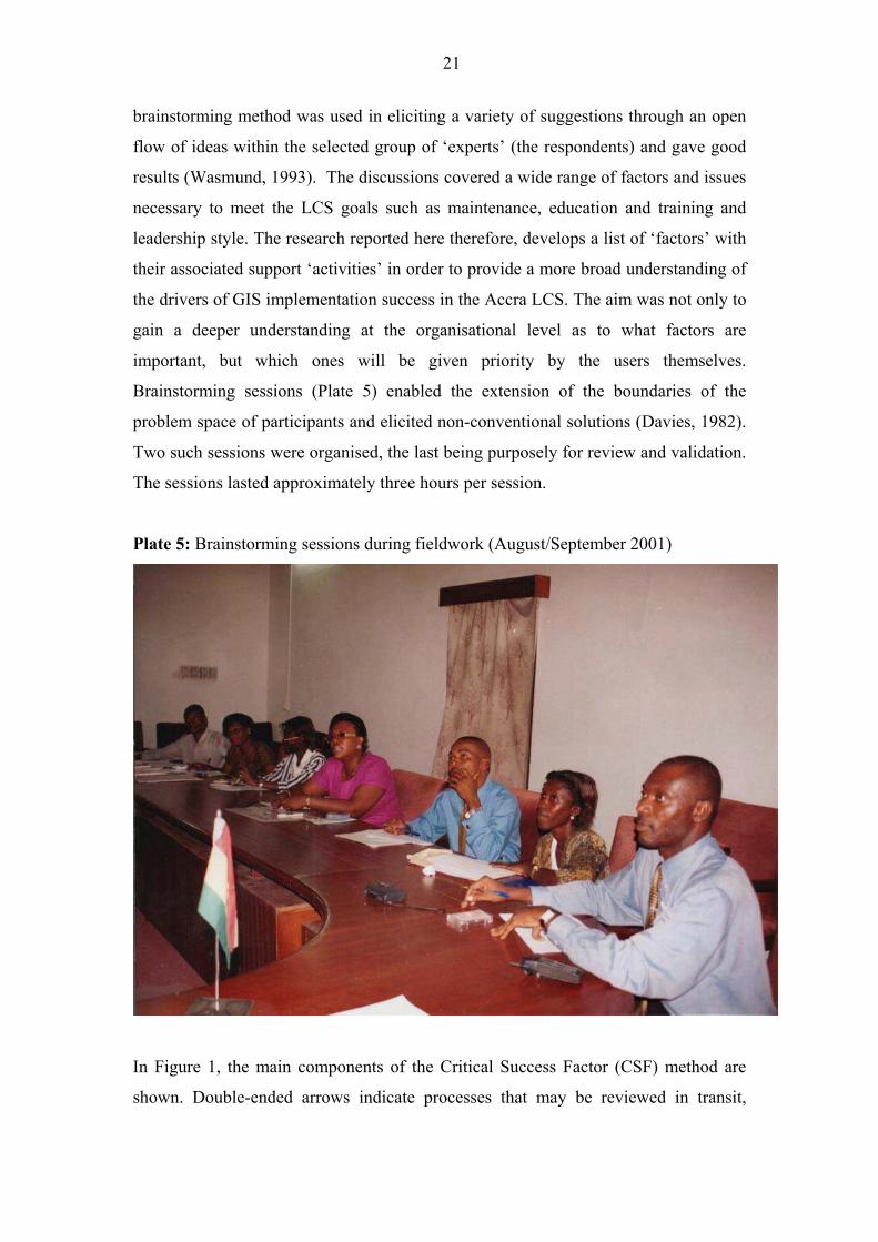
Brainstorming sessions (Plate 5) enabled the extension of the boundaries of the
problem space of participants and elicited non-conventional solutions (Davies, 1982).
Two such sessions were organised, the last being purposely for review and validation.
The sessions lasted approximately three hours per session.
Plate 5: Brainstorming sessions during fieldwork (August/September 2001)
In Figure 1, the main components of the Critical Success Factor (CSF) method are
shown. Double-ended arrows indicate processes that may be reviewed in transit,
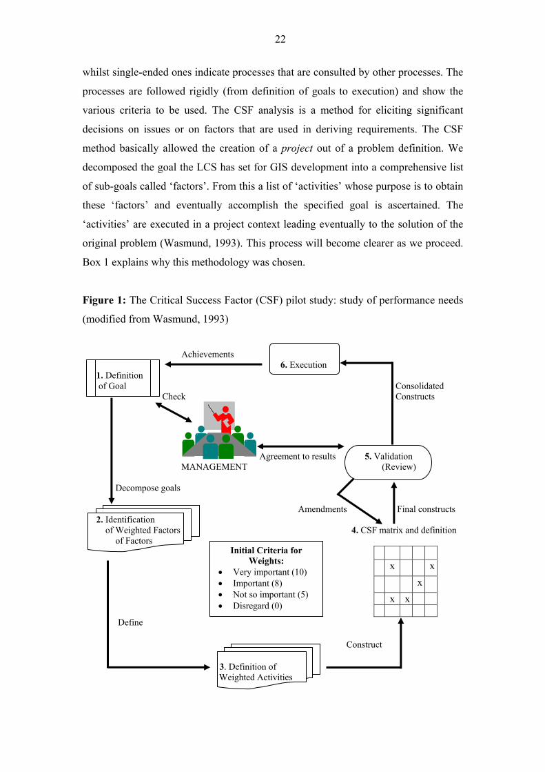
22
whilst single-ended ones indicate processes that are consulted by other processes. The
processes are followed rigidly (from definition of goals to execution) and show the
various criteria to be used. The CSF analysis is a method for eliciting significant
decisions on issues or on factors that are used in deriving requirements. The CSF
method basically allowed the creation of a project out of a problem definition. We
decomposed the goal the LCS has set for GIS development into a comprehensive list
of sub-goals called �factors�. From this a list of �activities� whose purpose is to obtain
these �factors� and eventually accomplish the specified goal is ascertained. The
�activities� are executed in a project context leading eventually to the solution of the
original problem (Wasmund, 1993). This process will become clearer as we proceed.
Box 1 explains why this methodology was chosen.
Figure 1: The Critical Success Factor (CSF) pilot study: study of performance needs
(modified from Wasmund, 1993)
Achievements
6. Execution 1. Definition
of Goal Consolidated
Check Constructs
Agreement to results 5. Validation
MANAGEMENT (Review)
Decompose goals
Amendments Final constructs 2. Identification
of Weighted Factors 4. CSF matrix and definition
of Factors
x x
x
x x
Define
Construct
3. Definition of
Weighted Activities
Initial Criteria for
Weights:
• Very important (10)
• Important (8)
• Not so important (5)
• Disregard (0)
23
In the next part of this paper, the six steps in the CSF methodology will be explained
and this is followed by an overview of the prioritised critical factors deemed
necessary by respondents for successful GIS implementation. This is then followed by
general observations made and the problems encountered in the entire exercise. Major
findings and discussions are presented and respondent characteristics are analysed to
determine the overall implication for GIS use.
Box 1: Why the CSF was used
The CSF methodology was chosen over the other methods such as the Business
System Planning (BSP) developed by IBM Corporation because:
• it required relatively little effort to arrive at critical factors for ensuring the LCS
systems� success;
• it was a means to recognise and eliminate redundant activities in order to focus
resources on crucial areas of concern to the Accra LCS; and
• the selected respondents were involved as it is a method of eliciting requirements
by asking them to define the factors that are crucial to success in performing their
functions or in making decisions (Davies, 1982).
5.1.1 Step One: Definition of the LCS Goal
As previously noted, the goal of the LCS (as adapted from the mission statement of
the Lands Commission) to establish a full-fledged GIS implementation was included
as part of the discussions in the brainstorming sessions to help create awareness. The
rationale of the goal for GIS development is to build a system that delivers quickly
and is error-free as much as possible and that generates the expected revenue with
respect to land administration and management. It is worth mentioning here that we
tried to make the goal as exact as possible since succeeding steps depend heavily on
it. The purpose, scope and time frame have been included and are made as specific as
possible (Wasmund, 1993).
24
5.1.2 Step Two: Identification of Weighted Factors
The respondents are asked to identify �factors� that will ensure the success of GIS
implementation through intense discussions and consensus building. The analyst(s)
had some factors that had been predefined for adoption6 even though respondents
were told to freely modify, discard or add to such factors as they pleased. They were
not only to identify but also prioritise such factors by initially awarding scores into
four main criteria, namely a score of 10 (Very Important); a score of 8 (Important); 5
(Not So Important); and 0 (Disregard). The requirement was to identify those factors
that are significant by system of ordering and deriving a set of �activities� that might
support these �ordered factors�. The initial ordered or weighted factors identified by
respondents are shown in Table 2. The reference number has no significance except to
uniquely reference a factor whilst the order of factors is in alphabetical order within
each group. The meaning of every factor was given to enable the respondents to fully
understand each factor (Appendix 1). This initial selection and scoring process
allowed the relationship between the �factors� and the respondents� perception of GIS
success in the LCS to be analysed.
Respondents initially disregarded �transportation and mobility� citing the fact that (for
administrative reasons) it was a general requirement and had nothing to do with the
use of GIS per se. These initial designations will change, as would be seen shortly,
after validation. It is important to state that we are, particularly, interested in the
critical �factors� for GIS implementation. We will therefore intentionally delay
discussions on �factors� until �activities� to support them are first defined to help us
understand fully the methodology. Once the factors are chosen, their associated
activities can easily be identified and linked to them.
5.1.3 Step Three: Definition of Required Weighted Activities for the Accra LCS
In contrast to the first step of defining �factors�, the next step of defining activities
expresses the work to be performed that would satisfy one or several factors. Again,
most of these activities had been pre-defined by the researcher(s). However, there was
6 Some factors were predefined to enable easy discussions. It was necessary that this
be done, looking at the level of experience of respondents in GIS. The factors were
selected based on other countries� experiences that the analyst(s) found germane to
the LCS situation.
25
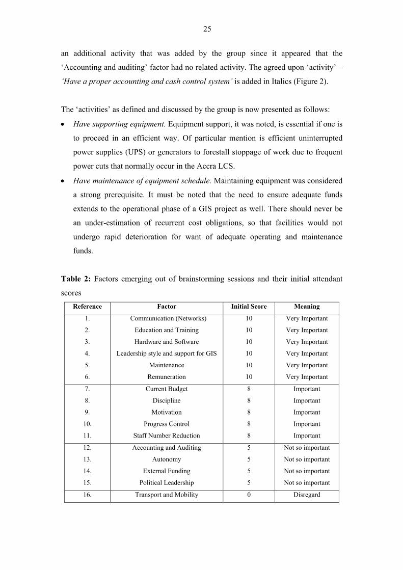
an additional activity that was added by the group since it appeared that the
�Accounting and auditing� factor had no related activity. The agreed upon �activity� �
�Have a proper accounting and cash control system� is added in Italics (Figure 2).
The �activities� as defined and discussed by the group is now presented as follows:
• Have supporting equipment. Equipment support, it was noted, is essential if one is
to proceed in an efficient way. Of particular mention is efficient uninterrupted
power supplies (UPS) or generators to forestall stoppage of work due to frequent
power cuts that normally occur in the Accra LCS.
• Have maintenance of equipment schedule. Maintaining equipment was considered
a strong prerequisite. It must be noted that the need to ensure adequate funds
extends to the operational phase of a GIS project as well. There should never be
an under-estimation of recurrent cost obligations, so that facilities would not
undergo rapid deterioration for want of adequate operating and maintenance
funds.
Table 2: Factors emerging out of brainstorming sessions and their initial attendant
scores
Reference Factor Initial Score Meaning
1.
2.
3.
4.
5.
6.
Communication (Networks)
Education and Training
Hardware and Software
Leadership style and support for GIS
Maintenance
Remuneration
10
10
10
10
10
10
Very Important
Very Important
Very Important
Very Important
Very Important
Very Important
7.
8.
9.
10.
11.
Current Budget
Discipline
Motivation
Progress Control
Staff Number Reduction
8
8
8
8
8
Important
Important
Important
Important
Important
12.
13.
14.
15.
Accounting and Auditing
Autonomy
External Funding
Political Leadership
5
5
5
5
Not so important
Not so important
Not so important
Not so important
16. Transport and Mobility 0 Disregard
26
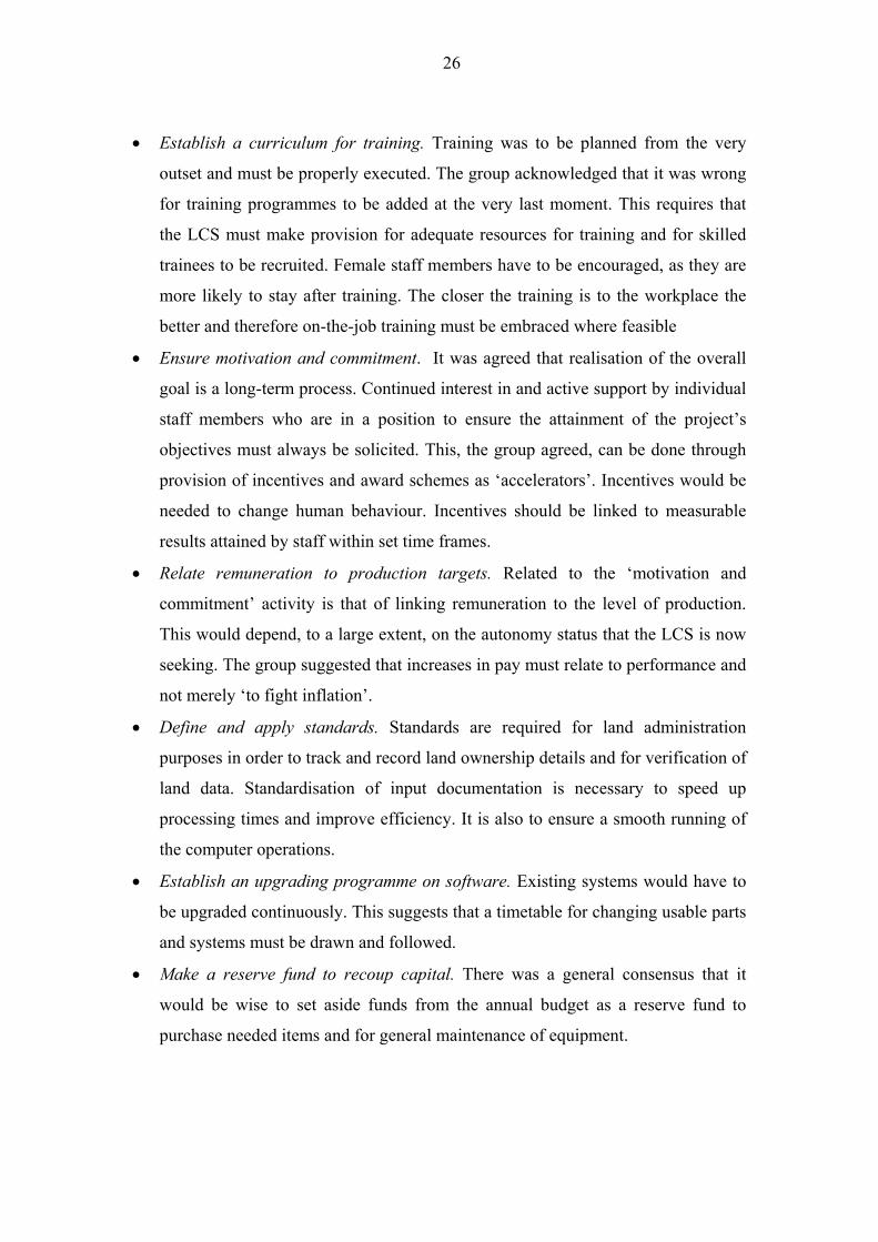
• Establish a curriculum for training. Training was to be planned from the very
outset and must be properly executed. The group acknowledged that it was wrong
for training programmes to be added at the very last moment. This requires that
the LCS must make provision for adequate resources for training and for skilled
trainees to be recruited. Female staff members have to be encouraged, as they are
more likely to stay after training. The closer the training is to the workplace the
better and therefore on-the-job training must be embraced where feasible
• Ensure motivation and commitment. It was agreed that realisation of the overall
goal is a long-term process. Continued interest in and active support by individual
staff members who are in a position to ensure the attainment of the project�s
objectives must always be solicited. This, the group agreed, can be done through
provision of incentives and award schemes as �accelerators�. Incentives would be
needed to change human behaviour. Incentives should be linked to measurable
results attained by staff within set time frames.
• Relate remuneration to production targets. Related to the �motivation and
commitment� activity is that of linking remuneration to the level of production.
This would depend, to a large extent, on the autonomy status that the LCS is now
seeking. The group suggested that increases in pay must relate to performance and
not merely �to fight inflation�.
• Define and apply standards. Standards are required for land administration
purposes in order to track and record land ownership details and for verification of
land data. Standardisation of input documentation is necessary to speed up
processing times and improve efficiency. It is also to ensure a smooth running of
the computer operations.
• Establish an upgrading programme on software. Existing systems would have to
be upgraded continuously. This suggests that a timetable for changing usable parts
and systems must be drawn and followed.
• Make a reserve fund to recoup capital. There was a general consensus that it
would be wise to set aside funds from the annual budget as a reserve fund to
purchase needed items and for general maintenance of equipment.
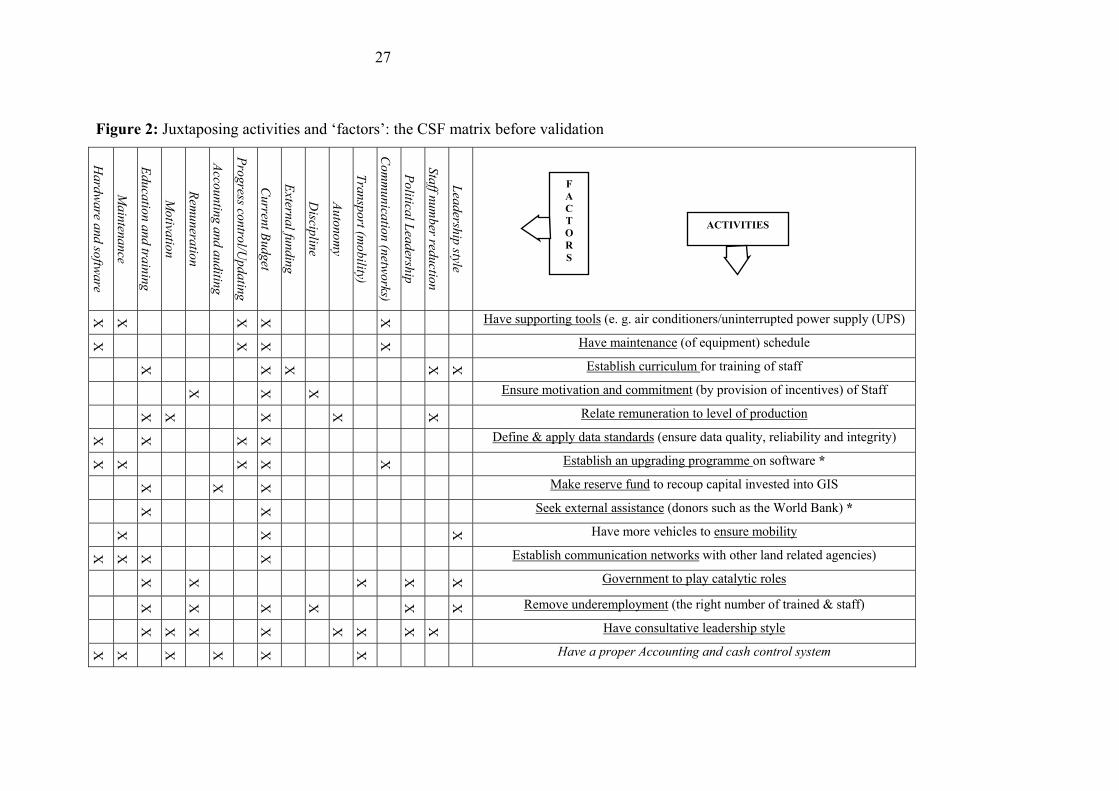
27
Figure 2: Juxtaposing activities and �factors�: the CSF matrix before validation
Ha
rdw
are a
nd
softw
are
Main
tenance
Edu
catio
n a
nd tra
inin
g
Mo
tivatio
n
Rem
un
eratio
n
Acco
un
ting
and
aud
iting
Pro
gress co
ntro
l/Up
da
ting
Cu
rrent B
ud
get
Extern
al fu
nd
ing
Discip
line
Au
tono
my
Tra
nsp
ort (m
ob
ility)
Co
mm
un
icatio
n (n
etworks)
Po
litical L
ead
ership
Sta
ff num
ber red
uctio
n
Lea
dersh
ip style
X X X X X Have supporting tools (e. g. air conditioners/uninterrupted power supply (UPS)
X X X X Have maintenance (of equipment) schedule
X X X X X Establish curriculum for training of staff
X X X Ensure motivation and commitment (by provision of incentives) of Staff
X X X X X Relate remuneration to level of production
X X X X Define & apply data standards (ensure data quality, reliability and integrity)
X X X X X Establish an upgrading programme on software *
X X X Make reserve fund to recoup capital invested into GIS
X X Seek external assistance (donors such as the World Bank) *
X X X Have more vehicles to ensure mobility
X
X
X X Establish communication networks with other land related agencies)
X X X X X Government to play catalytic roles
X X X X X X Remove underemployment (the right number of trained & staff)
X
X
X X X
X X
X Have consultative leadership style
X X X X X X Have a proper Accounting and cash control system
ACTIVITIES
F
A
C
T
O
R
S
28
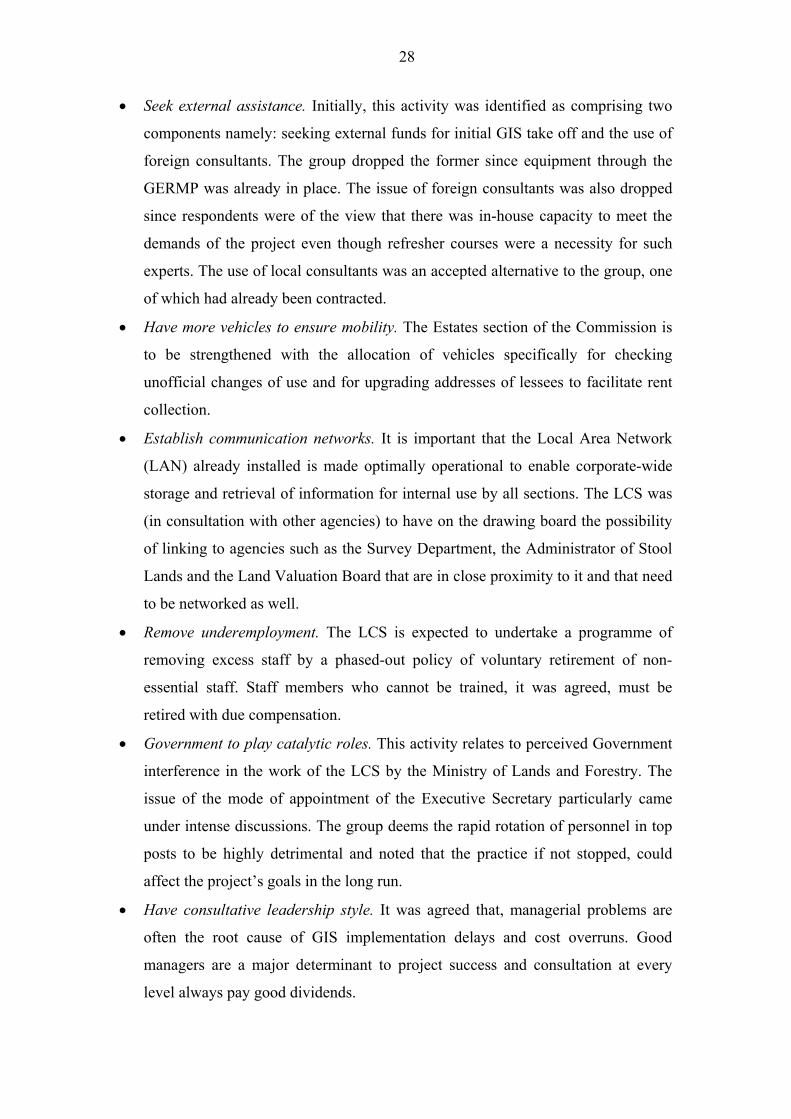
• Seek external assistance. Initially, this activity was identified as comprising two
components namely: seeking external funds for initial GIS take off and the use of
foreign consultants. The group dropped the former since equipment through the
GERMP was already in place. The issue of foreign consultants was also dropped
since respondents were of the view that there was in-house capacity to meet the
demands of the project even though refresher courses were a necessity for such
experts. The use of local consultants was an accepted alternative to the group, one
of which had already been contracted.
• Have more vehicles to ensure mobility. The Estates section of the Commission is
to be strengthened with the allocation of vehicles specifically for checking
unofficial changes of use and for upgrading addresses of lessees to facilitate rent
collection.
• Establish communication networks. It is important that the Local Area Network
(LAN) already installed is made optimally operational to enable corporate-wide
storage and retrieval of information for internal use by all sections. The LCS was
(in consultation with other agencies) to have on the drawing board the possibility
of linking to agencies such as the Survey Department, the Administrator of Stool
Lands and the Land Valuation Board that are in close proximity to it and that need
to be networked as well.
• Remove underemployment. The LCS is expected to undertake a programme of
removing excess staff by a phased-out policy of voluntary retirement of non-
essential staff. Staff members who cannot be trained, it was agreed, must be
retired with due compensation.
• Government to play catalytic roles. This activity relates to perceived Government
interference in the work of the LCS by the Ministry of Lands and Forestry. The
issue of the mode of appointment of the Executive Secretary particularly came
under intense discussions. The group deems the rapid rotation of personnel in top
posts to be highly detrimental and noted that the practice if not stopped, could
affect the project�s goals in the long run.
• Have consultative leadership style. It was agreed that, managerial problems are
often the root cause of GIS implementation delays and cost overruns. Good
managers are a major determinant to project success and consultation at every
level always pay good dividends.
29
• Have a proper accounting and cash control system. As noted, this activity was
added after discussions. This was to ensure transparency in the accounts of the
GIS project during and after computerisation. There is the need to have a general
outline or financial plan to ensure availability of funds and for checking possible
dissipation of funds.
5.1.4 Step Four: The CSF Matrix and Definition of Factors
Apart from the fact that the CSF methodology allows the recognition of unsupported
factors for which no activities have so far been defined or vice versa, it allows the
juxtaposition of weighted factors and activities and the subsequent removal of all
redundant activities. (These redundant activities have asterisks associated with them
in Figure 2).
The relation of �activities� to �factors� is that of one-to-many relationship. One
�activity� can support one or more �factors�. When the weighted �factors� and
�activities� were juxtaposed and the respondents were asked in the brainstorming
session to mark the ties between them there was confusion! For while initially
�Current budget� was seen as �important� it came to supersede all factors as it had
fourteen activities (93% of all activities) supporting it and therefore was actually the
most important factor. This was followed by �Education and Training� with eight
activities (53%) supporting it. This called for a more careful analysis. The group
acknowledged that they had been rash with the scoring process from the very
beginning. The goal of the LCS had to be re-examined. Analysing the goal, we found
that the LCS is concerned with land information administration and management and
with revenue generation for Government. It was therefore necessary, among other
things, to establish a land information infrastructure devoid of errors, that delivers
quickly and that will also link with other land agencies with the view of ensuring
increased revenue base for the LCS.
Table 3 shows the new criteria indicating the frequencies and associated percentages
that implicitly also show the respondents� preferences and perception of GIS success
in the LCS. Comparison of Tables 2 and 3 shows an interesting phenomenon. The
�Communication (Networks)� factor has moved from �very important� to �important�
30
and �Current Budget� from �important� to �very important�. �Progress Control� moves
from �important� to the �very important� category whilst �Autonomy�, �Political
Leadership� and Accounting and Auditing� move form �not so important� to
�important�. The �Transport and mobility� factor is promoted from the �disregard�
criterion to �important. The only �not so important� factor had come to be the
�External Funding� Factor.
Based on this review exercise, the �disregard� criterion was changed into �not
necessary� criterion and given a score of zero by the group. No factor was given this
criterion unlike the initial assignment of the �disregard� criterion to the
�Transportation (mobility)� factor. New scores were therefore set resulting in criteria
or meaning that were to be associated with any one factor (Table 3). Factors with a
score of greater than or equal to 4 activities supporting it were deemed �very
important�. Those between 2 � 3 inclusive were �important�, 1 was �not so important�
and 0 was �not necessary�. The allocation of scores was simple. The ties relating to a
specific factor were counted. If the count fell within a particular range then it
qualified for that criterion. For example, �Hardware and Software� had 6 ties. It fell
within a range greater than 4 and therefore qualified as �very important�. It is this
review that is sent to top management for further review and validation and
acceptance.
31
Table 3: Reviewed �factors� and their prioritisation by respondents in a brainstorming
session
Reference Factor New
Score
New
Meaning
Frequency
(n = (15), 13)
Per
Cent
7.
2.
3.
4.
5.
6.
Current Budget
Education and Training
Hardware and Software
Leadership Style & GIS support
Maintenance
Remuneration
≥ 4
≥ 4
≥ 4
≥ 4
≥ 4
≥ 4
Very Important
Very Important
Very Important
Very Important
Very Important
Very Important
(14) 12
8
(6) 5
4
4
4
(93) 92
62
(40) 38
31
31
31
9.
15.
10.
11.
16.
12.
13.
1.
8.
Motivation
Political Leadership
Progress Control
Staff Number Reduction
Transportation (Mobility)
Accounting and Auditing
Autonomy
Communication (Network)
Discipline
2 � 3
2 � 3
2 � 3
2 � 3
2 � 3
2 � 3
2 � 3
2 � 3
2 � 3
Important
Important
Important
Important
Important
Important
Important
Important
Important
3
3
3
3
3
2
2
(3) 2
2
23
23
23
23
23
15
15
(20) 15
15
14. External Funding 1 Not so important 1 8
- - 0 Not necessary - 0
Note: (n is the total number of �activities� that would support any �factor� e.g. 12 activities support the
�current budget� factor � after removal of redundancies. Before redundancies were removed, 14
activities supported it). Figures in brackets indicate values before redundancies were removed.
5.1.5 Step five: Validation and Review
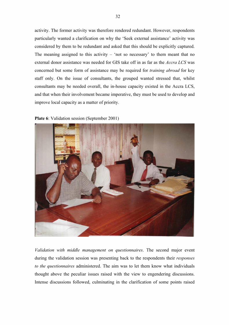
Validation with middle management on CSF methodology. Validation took the form
of presenting back to the respondents their responses during the brainstorming
sessions to determine whether their requirements were captured correctly (Plate 6).
The various factors and activities for GIS use were verified as correct, and the CSF
matrix was accepted as a true reflection of respondents� initial position on issues
raised. Before then, two things occurred to the matrix. Firstly, it was noticed that the
�Establish a upgrading programme on software� activity, could merge with the �Have
supporting tools� activity� since the former was subsumed in the latter. The same
marked ties are replicated. One activity � �Have supporting tools and upgrading
programme� was then proposed and accepted. Secondly, in the same vein, the �Seek
external assistance� activity was covered by the �Make reserve fund to recoup capital�
32
activity. The former activity was therefore rendered redundant. However, respondents
particularly wanted a clarification on why the �Seek external assistance� activity was
considered by them to be redundant and asked that this should be explicitly captured.
The meaning assigned to this activity � �not so necessary� to them meant that no
external donor assistance was needed for GIS take off in as far as the Accra LCS was
concerned but some form of assistance may be required for training abroad for key
staff only. On the issue of consultants, the grouped wanted stressed that, whilst
consultants may be needed overall, the in-house capacity existed in the Accra LCS,
and that when their involvement became imperative, they must be used to develop and
improve local capacity as a matter of priority.
Plate 6: Validation session (September 2001)
Validation with middle management on questionnaires. The second major event
during the validation session was presenting back to the respondents their responses
to the questionnaires administered. The aim was to let them know what individuals
thought above the peculiar issues raised with the view to engendering discussions.
Intense discussions followed, culminating in the clarification of some points raised
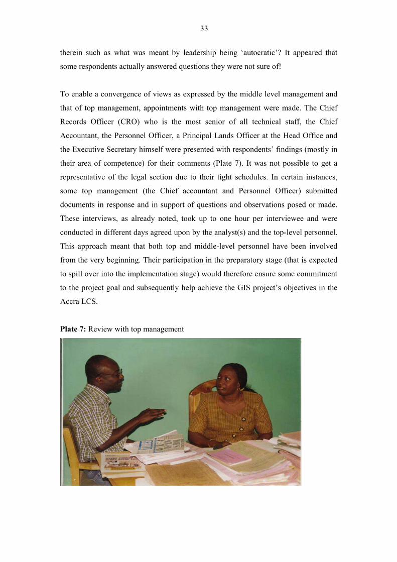
33
therein such as what was meant by leadership being �autocratic�? It appeared that
some respondents actually answered questions they were not sure of!
To enable a convergence of views as expressed by the middle level management and
that of top management, appointments with top management were made. The Chief
Records Officer (CRO) who is the most senior of all technical staff, the Chief
Accountant, the Personnel Officer, a Principal Lands Officer at the Head Office and
the Executive Secretary himself were presented with respondents� findings (mostly in
their area of competence) for their comments (Plate 7). It was not possible to get a
representative of the legal section due to their tight schedules. In certain instances,
some top management (the Chief accountant and Personnel Officer) submitted
documents in response and in support of questions and observations posed or made.
These interviews, as already noted, took up to one hour per interviewee and were
conducted in different days agreed upon by the analyst(s) and the top-level personnel.
This approach meant that both top and middle-level personnel have been involved
from the very beginning. Their participation in the preparatory stage (that is expected
to spill over into the implementation stage) would therefore ensure some commitment
to the project goal and subsequently help achieve the GIS project�s objectives in the
Accra LCS.
Plate 7: Review with top management
34
5.1.6 Step six: Execution of Activities in Support of Prioritised Factors
The LCS pilot project would be deemed to be successful if it achieves a moderate to
high rate of return after investment, and if the Commission is strengthened in terms of
its structure and hierarchy and policies, so that a solid foundation for sustainability is
laid for the GIS project. But how do we ensure the successful execution of the agreed
activities? The application of the CSF methodology has helped in determining, co-
ordinating and tracking crucial factors and activities that are required for introducing a
full-fledged GIS into the LCS in Accra. The method does not itself support
implementation and execution of the identified activities. Implementation has to be
carefully tailored to the Accra LCS local environment and culture in order to be
effective (Wasmund, 1993).
It has been observed that the success of GIS implementation would depend, among
others, on autonomy being given to the LCS to enable it carry out its activities in
accordance with broad goals and specific performance targets agreed on with
Government. The successful execution of activities to support the project goal would
also depend on certain institutional changes that were imminent, and on how each
member of staff would personally assess the implication of GIS introduction into the
system. It will depend on sustained management support and commitment and on the
availability of dedicated a GIS champion(s). It would also depend on appropriate
design and adequate preparation. A strong financial base and a pilot project approach
preceded by prototype software on identified application areas will provide the best-
sustained results in practice. This is despite the fact that the pilot project will require a
fair amount of patience from the LCS management or even Government who are
expected to issue funds to support the project. It must be stressed that, continuity of
staffing for the initial design through implementation is necessary so that those
responsible for design and for implementation have access to each other for a lengthy
time period.
We will now present results obtained by the brainstorming session giving an overview
of the prioritised critical factors that we found are necessary to support the GIS
project goal.
35
5.2 Critical Success Factors Identified
Respondents were of the opinion that to be able to have a successful GIS, the Accra
LCS must first and foremost aim at having a sound revenue base (Current budget)
(92%) on which to operate. This supports the view that future budgets must start with
current budgets (Loy, 1997). Insistence on financial viability (based on the LCS own
resources) is an important means by which discipline would be imposed on the Accra
LCS whilst encouraging efficient management and use of available resources.
Ironically, the group was of the opinion that it is only the introduction of a full-
fledged GIS in the LCS that would ensure a sustainable financial base. There must be
sufficient funds both to complete the GIS project and to operate and maintain it. The
present system as it is now (in the Accra LCS) may not warrant any foreign assistance
for take off. The group, as noted, attributed this to the legacy left by the GERMP and
to the current policy of management on computerisation.
To be able to meet the overall goal set by the Accra LCS on GIS implementation, the
LCS must have a well�trained staff needed to create the appropriate mind set and
establish the necessary technical skills. This supports the view that appropriate staff
with requisite training must be available and that staff who are lacking in the
necessary technical and communicative skills are most likely to ensure failure (Fox,
1991; Edralin, 1991 and Huxhold, 1991). Education and training (62%) including in-
house and workshops are therefore necessary ingredients to update knowledge.
Training may be supplemented by external funding (8%) through sponsorship of
courses abroad for a core group (only) who are expected to train others locally. The
group thought that overall, the external funding factor was �not so important�, since
such a core group have already been trained abroad but are scattered in the regional
offices of the Commission with the Accra LCS alone benefiting substantially. Short
refresher courses are needed for key staff with GIS knowledge to enable proper
orientation and teaching of new ideas to take place.
The existing hardware and software (38%) need to be upgraded or replaced regularly.
All offices must be linked to the Local Area Network with each office having
computers for use so that work processes can be automated as far as possible. Closely
linked to a good networking system (23%), the group observed was an effective
maintenance (31%) programme to maintain existing hardware and to update software
36
and make necessary backups. This presents an enormous challenge to management as
Ghanaians generally �lack a maintenance culture�.
Leadership style and top management support (31%) for GIS was required for a
lengthy time period. This supports the view that full management support and
involvement in the execution of GIS projects with such projects directed at intended
GIS beneficiaries is an important requirement. For this reason, inappropriate
management styles will obscure direction and put investment in GIS at risk. It is
important that good political leadership (23%), especially as it relates to the mode of
appointment of the Executive Secretary of the Commission, was considered. All were
in agreement that the post ought to be advertised and the selection procedure made
transparent. Frequent changes in the media of the top post must stop to enable policies
to be fully implemented. There is also the need for the LCS to be given greater
operational freedom to carry out its assigned task. Why for instance would the
Executive Secretary require ministerial approval for the appointment of a Systems
Administrator to help in GIS implementation? The LCS ought only to be held more
accountable for results and not be crippled by unnecessary bureaucracy.
On progress control (31%), the respondents are particularly interested in monitoring
progress towards the set goal. Progress control comprises definition of progress,
checkpoints and milestones. Proper accounting and auditing (15%) are required in
order to record exchanges and associated costs in GIS implementation. The practice
of involving internal auditors, as part of a complete team that looks at future computer
developments is worth considering. This is expected to lead to controls and security
surrounding any new development. The low percentage rate (13%) is attributable to
respondents� view that such a factor is needed whether GIS is in place or not and
therefore �does not exert any positive peculiar pull� with GIS implementation.
When it came to discussions on staff number reductions (23%), some respondents
were initially apprehensive. However, the majority were of the view that there was
need to remove underemployment, which already existed in the LCS as part of the
Civil Service legacy. Associated with this was the idea that the retained staff should
be computer literate as far as possible. These must undergo some motivation (23%) to
attain higher standards, especially in the area of professionals who have to change
37
their practice. This, of course, is related to better remuneration (31%). Ideally, better
salaries commensurate with job descriptions and performance is a necessary
prerequisite for continuity in the job. The idea is to stop �brain drain� after training.
Discipline (15%) is required in a system such as the LCS where indiscipline thrives.
From the very top to the bottom hierarchy and authority must be respected.
Mobility (23%) is another issue that was extensively discussed. Whilst initially this
�factor� was disregarded the ensuing review raised the need to reconsider this factor.
The group was of the view that transportation will be necessary for site inspections in
an updating information programme. Changes of use on the estates managed by the
Commission without consent and encroachments could be monitored this way.
Addresses of lessees could be easily checked and updated enabling effective rent
collection if mobility is assured. However, respondents insisted that since this
responsibility would most probably be ceded to the private sector (if management is
to lend its support), transportation as a �factor� was extraneous to the LCS in GIS
implementation. Ironically, in the filling of the questionnaire 13 out of the 15
respondents did not want to see the private sector get directly involved in the work of
the Commission, especially in the area of rent collection, that respondents
acknowledged had serious shortcomings! Evidently, the respondents were suspicious.
The element of suspicion engenders in them a natural tendency to resist any
interference in their domain of influence.
5.3 General Observations and Problems Encountered
An essential element of this empirical survey is the identification of problems found
with the brainstorming and validation sessions and subsequently with the responses
(users� characteristics) to questionnaires administered.
5.3.1 Problems Associated with Brainstorming and Validation Sessions
• The analysts� knowledge and experience are assessed. The problems associated
with the two sessions brought to the fore the fact that the analysts ought to be
knowledgeable in the proposed system and be experienced with the current
information system to enable him to correctly structure the problem space. This
38
became evident during the sessions, as the analyst(s) had to constantly draw on his
experience.
• Detection of contributions by a vocal few. A few of the respondents made
contributions during the sessions. Five males and two females of the fifteen
participants appeared to be dominating proceedings. This is a problem associated
with brainstorming sessions. Reliance on such a vociferous few alone could not
elicit complete and reliable requirements even though to the Ghanaian, �silence
means consent�. On this note, review sessions with top management become
crucial if results obtained from such a small subset of the sample are not to be
treated with doubt and utmost caution. The questionnaires given for individual
assessment also helped to reduce any such shortcoming.
• Difficulty in eliciting information due to changing requirements. The analysts had,
in some instances, assumed that requirements (such as factors under the CSF
method) were known and had fixed them prior to these sessions. However, the
constant change of direction through debate meant a lot of fine-tuning and
modifications. The recording of proceedings on tape helped to ensure that
requirements were captured correctly and cross-checked. The validation session
proved very significant as it accorded the group the chance to review and accept
facts collected by the analyst(s) as a true reflection of their views.
• Rashness in the scoring process. As a corollary of the previous point, some
indiscretion in the scoring process on the �factors� and �activities� was detected in
the initial stages. The analyst(s) had to provide a good leverage so that the group
could remain focussed on the stated GIS goals by re-stating goals and objectives
of the proposed GIS project and by engendering intense discussions during
brainstorming sessions.
5.3.2 Problems associated with responses to questionnaire: users�
characteristics
• Non-participation. Two of the initial 17 respondents (both women) originally
picked by management did not attend the brainstorming session bringing the total
number of respondents who actually participated to 15. Incidentally, one of the
absentees attended the validation session. As expected, she sat through the session
as an observer and therefore never made any contributions. We can only provide
39
some allusion for this problem such as respondents� unwillingness to participate
or that they were kept away by pressing issues beyond their control, the latter
being a more plausible reason.
• Detection of non-commitment in filling of questionnaires. There was evidence
that at least one respondent was unwilling to participate or was totally
uncommitted. The level of commitment in answering questions may be
attributable to some ambiguity of some questions in the questionnaires7, the
respondents themselves having some difficulty in understanding and expressing
their requirements and/or the sheer unwillingness on the part of some respondents
to participate.
• Users give reasons or comments. On organisational issues only two respondents
(13%) gave reasons or comments for all the eight spaces provided for such
comments. One respondent gave just one comment. Comments given on
application issues were relatively low with only one providing comments to all
twelve spaces provided. One person again gave only two comments, that being
the lowest count. It can be concluded that respondents had difficulty expressing
their requirements, which may be because they are unfamiliar with the
specifications or did not devote sufficient time to communicate their requirements,
even though the former factor appear more likely to be the case.
• Detection of ambiguity and incompleteness. Some questions (as indicated earlier)
were either not too clear or presented some problems of interpretation. Some
responses were ambiguous especially those related to the issue of autonomy and
political interference. The validation session helped to iron out the differences.
5.4 Major Findings and Discussion
The brainstorming session can be viewed as a formal process as it involved following
well-defined steps in the use of the CSF methodology. The administration and filling
in of questionnaires were based on individual judgement and experience and therefore
constituted an informal process. The two complimented each other. However, there is
the possibility of a divergence between the two approaches and how they will relate to
the actual situation on the ground. The validation and review processes associated
7 During the validation session some concerns expressed related to clarifications of
some questions.
40
with the research helped to bridge this gap through an iterative process involving a
major level of learning between the researcher, the respondents and top management.
This gives weight to the now widely accepted view that to provide information
systems that meet user requirements will entail an iterative validation process (Avison
and Wood-Harper, 1990). We will now discuss the areas of agreements and
disagreements between views expressed by the fifteen respondents and that of top
management.
5.4.1 Areas of Agreement between Top Management and Respondents
• Political pressure from the Ministry of Lands and Forestry: The Executive
Secretary (ES) agreed with the five respondents who specified that they were
uncertain as to whether pressure from the Ministry was positive or negative. He
was of the opinion that the intervention from Government had always related to
pressure on the LCS to improve service delivery, reduce delays and introduce
transparent practices and saw such interventions as necessary whether it is seen as
positive or negative. The role of GIS in automating processes and thereby
speeding up such processes is therefore deemed crucial to the work culture of the
LCS.
• Autonomy: Whilst the ES saw that the Act that established the LCS seeks
autonomy for it, he was quick to explain that the push for autonomy related to
�financial and organisational autonomy�. This implies that the LCS must have the
�power� to employ and sack its own staff, determine its own level of
remuneration, and have its own budget. He said the present state where these
requirements are non-existent puts the LCS in a predicament. The LCS, for
instance, cannot sack recalcitrant members of staff that are seconded from the
Attorney General and Accountant General�s offices. If GIS is to be a unit or
department in the LCS as envisaged, then the unit ought to be given autonomy to
carry out its functions in accordance with agreed goals and specific performance
targets. This must be set within broad goals set by the government on autonomy
for the LCS as a whole. The set goals by government will hold the LCS
accountable for results, while improving the flow of information to Government
about the Commission�s performance. Eleven of the respondents are in agreement
with this view insisting that government�s role must be catalytic (speeding up the
41
work processes only).
• Government�s directives through the National Lands Commission (NLC): The ES
was in agreement with the majority of respondents who were of the opinion that
all directives from Government must be rooted through the NLC and in fact saw
this as a fait accompli. At the moment, however, the NLC is not sitting. For over a
year now the Chairperson and the ES take all decisions on behalf of the NLC. The
ES, however, saw the composition of the NLC (as stipulated by the Act) as too
large making it difficult for it to reach decisions at board level. Upon the
introduction of GIS, continued political support from government and the
establishment and optimal operation of all requisite institutions within the
appropriate policy frameworks will among others, engender growth and improve
access to information.
• Corruption: The factors that respondents think underpin the reason for corruption
in the LCS are, in order of priority, low wage levels, indiscipline, pressure from
the public, sheer greed and the culture of the LCS. On wage levels, for instance,
the Chief Accountant cited an example of a Senior Lands Officer (capable of
heading a regional office) with more than ten years of experience, and with a
second degree in GIS, taking a monthly net salary of ¢617,389 (approximately
£62) in July 2001! He has no allowance except that he may use a government
vehicle that is regulated and fuelled every week. He admits that enormous
pressure is put on staff because of very low remuneration. The ES, however,
thinks the issue of corruption has more to do with the shortage of staff and its
concomitant delays in the system. He is of the opinion that a system with limited
or no delays will remove �rent seeking� in the normal work processes since the
public is compelled to pay bribes to �jump queues�. Recalcitrant staff would
always create institutional bottlenecks as �hiding of files� in such an environment,
in order to foster illegal financial exchanges. For a successful implementation of a
GIS project, salaries and benefits for staff must be adequate to attract, retain and
motivate competent professional staff. It may mean raising pay levels of staff to
bring it closely in line with that of competing positions in the private sector. GIS
placed in a proper institutional setting will help change procedures that will enable
services to be delivered expeditiously.
• Position of Executive Secretary (ES): The ES gave approval in principle to
42
respondents desire to see changes in wage levels, and work processes and the
mode of appointments to the ES position (in that order) but chose to comment
rather extensively on the latter. He was of the view that the position ought to be
advertised to defeat the notion that the appointment is political and not based on
merit. He admitted that there is so much insecurity attached to the ES position that
one is �always looking over one�s shoulders and thinking when he would be
removed�. As noted elsewhere, discontinuity of management as a result of
frequent changes for political reasons can spell doom for any GIS project. It is
important to state also that good managers are often a major determinant of GIS
project success and it is imperative that leadership is appointed based on
qualification and competence in a transparent process as much as possible. It has
been noted that managerial problems are often the fundamental cause of GIS
implementation delays and cost overruns.
• Training: The ES admitted that training at the LCS had been at a �very low level�
but stressed that the current manual system is so very problematic that it has to be
improved substantially before a full-fledged computerisation programme is
embarked on. This accords with Zwart�s (1990) position that reforming existing
(manual) systems before introducing the computer is a major step to securing their
success. He admitted that even though nine persons have been trained in various
fields in GIS nation-wide, they had gone rusty as they had gone back to the
manual way of doing things. A change in organisational focus will help, he said.
For GIS, management and staff need training and skill development since the need
for skilled people remains urgent. The search for training strategies relevant to the
LCS institutional needs must continue. It may be necessary to train more staff than
are immediately required to forestall frequent loss of people once trained.
• Work processes most needed to be computerised: The ES like, the majority of the
respondents, would want to see that the searches process, leases and associated
consents, rent collection and management in relation to all aspects of state lands
are automated as a matter of priority. These are areas that are most likely to meet
the revenue objectives of the LCS aimed at covering operating costs and
contributing to investment from internally generated funds.
• Information as a corporate resource: Whilst top management agreed with the
respondents that information must be treated as a corporate resource, it was of the
43
view that such information should not be free or subsidised either. It must be �at
cost and not sold for profit�. In the public service where the LCS fits, cost
recovery can be a difficult issue. Practical administrative and political
considerations are determining factors. It is therefore clear that the introduction of
new fees or charges or a possible substantial increase in existing fees is more
likely to be accepted by the Ghanaian public after project implementation is well
advanced and some benefits have been derived from GIS use.
• Private participation: In the area of rent collection and management, the ES
agreed with the respondents that with the necessary financial support, better
training and stronger incentives, the staff of the LCS was capable of delivering
and ruled out any private participation in the LCS work processes. As already
noted, the limited management capacity of the LCS may require a re-think on this
issue. In this case, it is expected that a strong bond would be fostered between
management, staff and the private/local consultant if indeed private sector
participation was warranted.
• GIS as a Department: Top management shared the view of all respondents that
GIS must be a department on its own in the Accra LCS environment �but certainly
not a unit hiding somewhere�. It must be a full-fledged department well integrated
into the LCS system. It is therefore essential that the proposed GIS unit first
identifies and concentrates on activities central to the project�s objectives whilst
ensuring that co-ordination of the projects requirements are scrutinised. This will
require that authority for getting practical tasks done be clearly demarcated as well
as clear lines of responsibility mapped out in order to avoid unnecessary conflicts.
5.4.2 Areas of Disagreement between Management and Respondent
• The LCS is unnecessarily large? The ES disagreed with ten of the respondents
that the size of the LCS was unnecessarily large and therefore ought to be
trimmed, insisting that this assertion must be put in perspective. He stated that the
LCS is �bottom heavy� and �top light�, apparently referring to the small number of
qualified professionals, as compared to the large number of available
unprofessional staff; the LCS was understaffed from the angle of needed qualified
professionals. He suggested that, there was the need for some �needs assessment�
on the present stock as to whether to retrain or retrench any staff. This would
44
depend on the financial autonomy that the LCS so requires. He intimated that
since the �bottom heavy staff� is actually staff of the Civil Service, they cannot
just be laid off without adequate compensation and can at best be off loaded back
to the service. It is important to note that, at the heart of the performance of the
LCS, lay issues relating to morale, efficiency and competence of the civil servant.
There is evidence that such personnel at lower levels are overstaffed. Ironically,
salaries and benefits at the professional levels are inadequate and may not attract,
retain or motivate qualified professional staff. For GIS, there is the need to
identify redundant workers and help retrain and relocate them while efforts are
made to attract more professional staff through better salaries and incentives.
• Conflicts? The Chief Records Officer (CRO) and the ES dissociated themselves
with the respondents who saw conflicts existing between the Estates Section and
the Legal Section on one hand and that between the Estates section and both the
Accounts section and the Technical section on the other. Whilst agreeing that such
conflicts are normal with every organisation, they were of the view that, this was
an issue of the past and not related to the present administration which now has a
management team in place that meets fortnightly to iron out differences. Hitherto,
conflicts had related to approach to work and to how some technical issues had
been handled. It is to be observed that this observation is in agreement with the
reasons assigned for such conflicts by the respondents (leadership styles and roles
and work processes) but not in agreement with the groups� tacit acceptance of
such conflicts even under this administration. It is possible that the introduction of
GIS may bring some conflicts of its own. To avoid conflicts and possible delays in
the start-up phase and during the project implementation, all and sundry must
participate adequately in the GIS project preparation and design. Perhaps, a full
time project implementation team must be put in place as early as practicable
whose duty will include setting clear objectives and ensuring an efficient decision-
making authority.
• Management style autocratic? Again the ES and the CRO did not agree with the
nine respondents who said that management style for the past ten years had been
autocratic. They said it was normal for any leader to set up a team of loyalists with
whom to work with and that the close working relationships that normally existed
between such trustworthy and hardworking staff and management should not be
45
interpreted to mean that the rest are not consulted. The ES was of the opinion that,
what had transpired during that period, was a �monolithic style of administration�
where respective Executive Secretaries had �gone it alone� whenever they felt
their vision was being impeded. He insisted that this was �not necessarily
dictatorial but may not be consultative either� and wondered whether the word
�autocratic� was appropriate in such a case since they did not wield absolute
power in the actual sense of the word. However, the Personnel Officer cited a case
where in 1999, the then ES exchanged nineteen clerical staff for other staff of
various civil service sectors, without adequate consultation, on what was
unofficially attributed to corruption charges. As noted, good managers are a major
determinant of GIS project success. GIS projects, like any other projects, can get
into a vicious or virtuous cycle. There is the need, therefore, for a consultative
management style within the LCS administrative structure and with clearly
defined responsibilities that would involve a redefinition of tasks. The
clarification of who should do what must be spelt out early and they must be held
responsible for work outcomes whilst following the vision set up by management.
• Authority definition unclear? The ES again distinguished what must have
happened before he took over management and the situation as it pertains now. He
thinks authority definition and hierarchy in the LCS is now clear as opposed to the
eleven respondents who think otherwise. When pressed further, he admitted that
the respondents must have been looking at the junior staff and the way they
operate, citing the search office as an example. At this office, he said, it is difficult
to determine who is in control since the clerk responsible appears to report to no
one directly. But he insisted that this problem is now a thing of the past. With the
introduction of GIS, as with all systems, there must be direct action to improve
management and this may involve some carefully tailored reform of the LCS and
its policy frameworks. There must be agreement on objectives and the
establishment of performance criteria with clear lines of responsibility for all
sections. This may warrant a careful diagnosis of all problems and delineation of
possible solutions as a prerequisite for concrete action.
• The role of Accra LCS vis-à-vis the Head Office undefined? All 15 respondents
were of the view that the Accra Regional lands Commission must have a distinct
role from the Head Office as envisaged in the Lands Commission Act 483. They
46
stated that �the Head Office is virtually performing the duties of the Accra Office�
especially in the area of government lands. The ES insisted that the Head Office
would continue to deal with such lands, since such lands have assumed a �national
character�. His problem was that the entire process of dealing with state lands had
to start from the Accra Office and end at the Head Office and wondered why this
could not be handled entirely by the Head Office. The key question is, would
changing the LCS and its procedures as found in the Act help bring efficiency,
generate more accurate information and timely processes and make the
organisation more responsive to the public or would it stifle improvement? A
prudent course is warranted as the role of the ES in co-ordinating all the activities
of all Regional Lands Commissions should not be sacrificed at the altar of
political expediency.
• Transportation only important? In the use of the CSF methodology, the
respondents gave certain �activities� and their associated �prioritised factors� as
necessary requirements for GIS implementation in the LCS. Top management
generally agreed to these but insisted that transportation had not been given the
needed weight and should have been a �very important factor�. The ES,
particularly, was of the opinion that transportation was a major problem since an
exercise to review the status of all government-acquired lands through GIS use
would require vehicles. He said the LCS, by virtue of a legislative instrument, can
levy fees and charges to raise revenue to support its activities including purchase
of vehicles, but the government has frozen any purchases in that regard.
5.5 Implications for GIS Implementation in the Accra LCS
The issues raised may be used as bases for debate amongst the middle level
management (respondents) and top management concerning ways of addressing
divergence whilst some of the specific findings may be used as a focus for further
debate. Top management, it was realised, preferred to talk generally, placing
particular importance on policy issues. That there should be disagreements on major
policy issues among top management and middle-level management was expected.
The middle level personnel appear to have their own concerns, preferring to address
issues that directly affected them. They do have strong feelings about the qualities of
the LCS as a body, insisting generally on the need to see the job being done and being
47
done well. These concerns cannot be ignored and would have to be addressed in GIS
implementation.
It is to be realised that responses from the 15 respondents formed the basis for the
choice of the methodologies. Whilst this was a tactical approach, involving
management in the very beginning of requirement analysis would appear to be the
better approach. However, deciding to delay their involvement a little was to stress
the point that management and policies are bound to change with time. Conversely,
those in line and operational management who are expected to operate the system
may remain for a long period of time during the operational phase of the project and
beyond. In any case, conflicts of opinion only accentuate the level of uncertainty that
served as a barometer for the choice of the methodologies. Their early involvement, in
this particular case, would have had little effect.
A recurring theme of this research is that a pilot project(s) preceded by a selected
features prototype software of identified work processes is required and must be
expanded according to a set timetable if success of GIS implementation in the Accra
LCS is to be attained. This will involve initially identifying which activities are
central to the projects primary purpose (which this research has already elicited
through the CSF methodology). It would also involve, as indicated, subjecting these
findings to more debate to enable concentration of scarce institutional resources on
these prioritised factors or areas while deferring desirable but difficult or secondary
objectives until activities that are central to the GIS project�s primary purpose are well
established. Three questions can therefore be posed in this regard: a) Is the problem a
serious constraint on the functioning of the Accra LCS? b) Is the solution within the
capability of the Accra LCS to carry out? c) Is the current climate constructive for
sustained action? d) Can political and public support be mobilised and maintained for
the GIS project? The implications of these questions and how they are treated are
critical for full GIS implementation in the Accra LCS particularly and for its diffusion
in the land sector generally.
Part two of this paper will first discuss some of the features of the prototype software
called �LANDADMIN� that is developed for the Accra LCS. This is not a full-scale
model often referred to as a pilot. In other words this research is recommending a

48
selective and phased out approach that will eventually be part of a final system that is
delivered to the Accra LCS as a pilot. In this part of the paper, the use of �Data Flow
Analysis� method in deriving information about searches is shown as a key example
leading to prototyping for the Accra LCS. Discussions on the architecture of the
prototype software that is aimed at automating a range of routine land administrative
tasks will thereafter be tackled. The prototype will involve careful explanation,
documentation and training if it is to be successfully implemented, if continuous
funding (from within) is to be maintained and if the pilot project is to lead to a
sustainable implementation.
49
PART TWO
6 The �LANDADMIN� Prototype Software
The empirical survey indicated that on the spatial front, �searches� to determine
ownership status on state lands were to be automated as a matter of urgency. Rent
assessment and management is another area that, according to respondents�
requirements, required automation. The design of the prototype software is based on
respondents� requirements. ArcView 3.2 is used for the spatial data and Microsoft
Access for the non-spatial data, both of which have been installed in the LCS. As
already indicated, the Data Flow Analysis (DFA) is used to systematically define the
processes of the �search� procedure. Rent collection and management, are already
being undertaken using Microsoft Access. The research studied the present system (on
the LCS using Access) and identified areas for improvement. An improved design is
therefore made (on rent collection and management) incorporating other areas
recommended for improvement by the users (six selected staff who are expected to
operate the prototype software). The two methods (DFA and the Prototyping
methods) will now be explained.
The DFA, when used at a high level of analysis is a graphic method of defining
inputs, processes and outputs of systems. The process is top-down. It would help
simplify the detection of errors or bottlenecks between processes and data flows of
the �search� process through its associated data dictionary (meta database). The DFA
method was delayed until after the primary analysis method � CSF � had provided an
initial set of requirements (Davies, 1982) so that the application element of the LCS
information requirements would fit well into the organisational framework set by the
CSF methodology. The DFA is used in conjunction with the discovery methodology -
prototyping, which is the primary method applied at the application level.
Prototyping is in fact a �verification technique� (Sakthivel, 1991). The methodology
forces the analyst(s) or the systems developer to respond to users� identification of
deficiencies in information requirements (Braunstein et. al, 1991). It is defined here
to mean �a selected features prototype� (Kendall and Kendall, 1996) that includes
some but not all of the required features of the LCS information requirements and
which the users will attest to as their own since they had been involved in its design
from the very beginning. If the design (and implementation) is successful, it will be
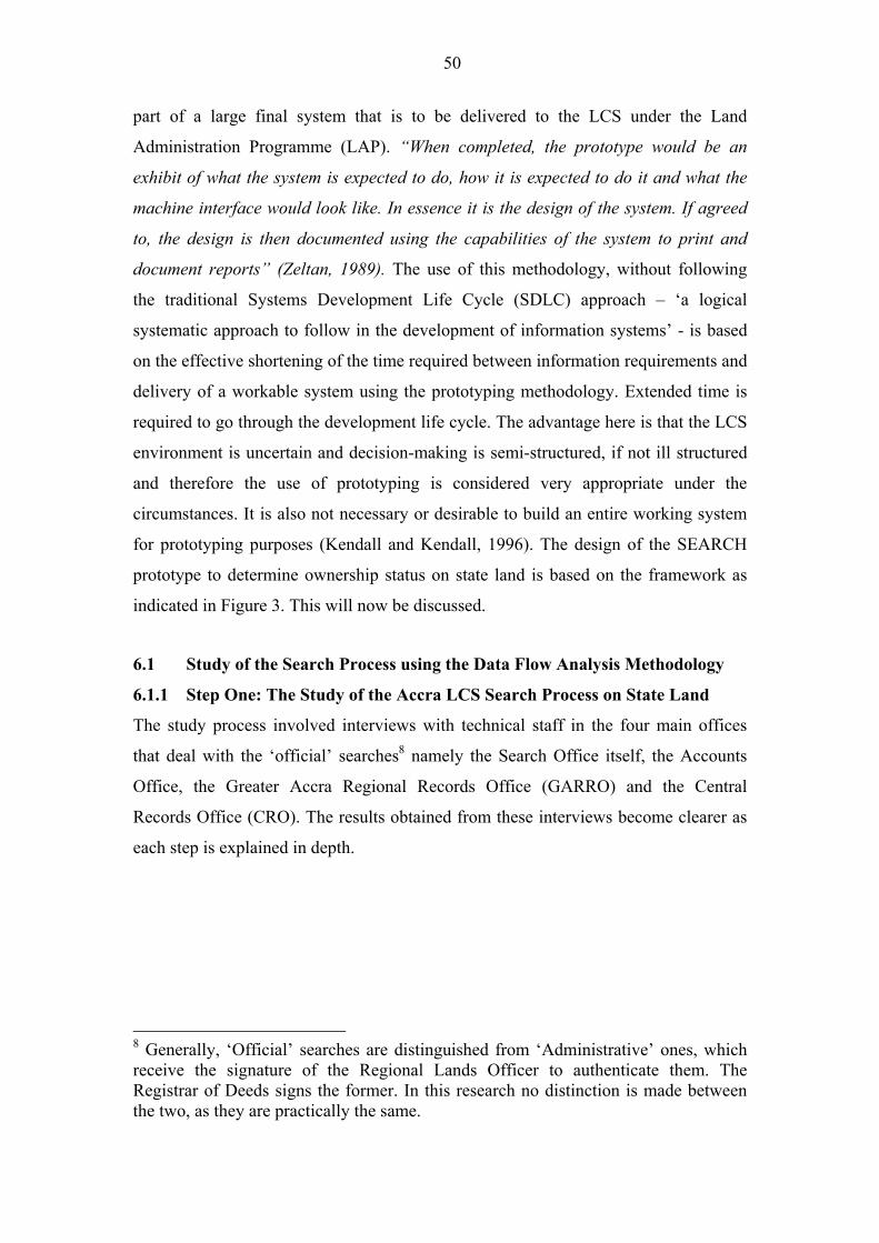
50
part of a large final system that is to be delivered to the LCS under the Land
Administration Programme (LAP). �When completed, the prototype would be an
exhibit of what the system is expected to do, how it is expected to do it and what the
machine interface would look like. In essence it is the design of the system. If agreed
to, the design is then documented using the capabilities of the system to print and
document reports� (Zeltan, 1989). The use of this methodology, without following
the traditional Systems Development Life Cycle (SDLC) approach � �a logical
systematic approach to follow in the development of information systems� - is based
on the effective shortening of the time required between information requirements and
delivery of a workable system using the prototyping methodology. Extended time is
required to go through the development life cycle. The advantage here is that the LCS
environment is uncertain and decision-making is semi-structured, if not ill structured
and therefore the use of prototyping is considered very appropriate under the
circumstances. It is also not necessary or desirable to build an entire working system
for prototyping purposes (Kendall and Kendall, 1996). The design of the SEARCH
prototype to determine ownership status on state land is based on the framework as
indicated in Figure 3. This will now be discussed.
6.1 Study of the Search Process using the Data Flow Analysis Methodology
6.1.1 Step One: The Study of the Accra LCS Search Process on State Land
The study process involved interviews with technical staff in the four main offices
that deal with the �official� searches8 namely the Search Office itself, the Accounts
Office, the Greater Accra Regional Records Office (GARRO) and the Central
Records Office (CRO). The results obtained from these interviews become clearer as
each step is explained in depth.
8 Generally, �Official� searches are distinguished from �Administrative� ones, which
receive the signature of the Regional Lands Officer to authenticate them. The
Registrar of Deeds signs the former. In this research no distinction is made between
the two, as they are practically the same.
51
Figure 3: The data flow analysis (DFA) and prototype design pilot study of official
searches on state land in the Accra LCS (Study of Functional Needs)
Create Achievement Reject
2. Context diagram
Discuss Accept
Refine
Discuss MANAGEMENT
3. Top � Level
Diagram 4a. Meta database 6. (Have)
Prototype
Factor Develop
4. Level - One 5. (Design)
Diagrams Guide Prototype
(Current situation)
Develop
4b. Level � One
(Input) Diagrams Construct
Typical Scenarios (Future Situation)
1. Study of
Processes
7. (Test)
Prototype
6.1.2 Step Two: The Accra LCS Context Diagram
To enable us structure the search process, the LCS boundaries and �terminators�
(users� and providers of the LCS information) are first defined. The context diagram
evolves from this (Figure 4). This shows the LCS in one process and indicates the
LCS services as a whole9. The diagram depicts the �terminators� such as the Ministry
of Lands and Forestry, the Land Valuation Board etc that shows linkages and
information exchanges between the LCS and outside agencies.
The Ministry of Lands and Forestry, for instance, provides policy guidelines to the
LCS and the LCS advises government on land matters through the Ministry. The
police would request search reports to determine ownership status over a piece of land
9 The �context� diagram can be used as a starting point in determining all application
requirements within the LCS as it represents all processes within and without the LCS
administrative system.
52
under police investigation and the LCS provides this report upon request. The District
Assemblies through their decentralised departments (the Town and Country Planning)
would request search reports from the LCS on applications received for planning
permission/building permit to determine the status of ownership. The traditional
authorities would normally request conflict resolution through the Regional Lands
Commission over disputed lands whilst a statutory corporation such as the State
Housing Company (SHC) would request approval for consent to either lease, sublease
or mortgage on behalf of their clients. The LCS is obliged to give its approval. The
context diagram, being the first step in the DFA methodology, therefore depicts the
LCS system as a whole with the search process being only a small part.
6.1.3 Step Three: Top-level Diagram - The �Searches� on State Land � Current
Situation.
A top-level diagram is then prepared zooming into the search process itself. This
enables the analyst to arrive at the level of details necessary for describing single
processes (Figure 5). There are six main �terminators� that are identified in the search
processing service. The Searches procedure comprises three main processes: (1) the
Search Office processing unit (deals with the receipt and processing of the search
application and liaises with the Accounts section for payment of fees) (Plate 8); (2)
the GARRO retrieval process; and the CRO retrieval process.
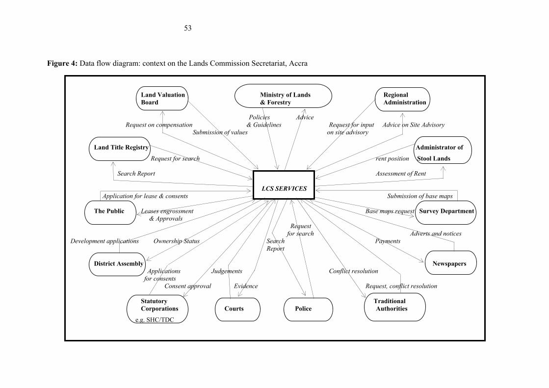
53
Figure 4: Data flow diagram: context on the Lands Commission Secretariat, Accra
Land Valuation Ministry of Lands Regional
Board & Forestry Administration
Policies Advice
Request on compensation & Guidelines Request for input Advice on Site Advisory
Submission of values on site advisory
Land Title Registry Administrator of
Request for search rent position Stool Lands
Search Report Assessment of Rent
LCS SERVICES Application for lease & consents Submission of base maps
The Public Leases engrossment Base maps request Survey Department
& Approvals
Request
for search Adverts and notices
Development applications Ownership Status Search Payments
Report
District Assembly Newspapers
Applications Judgements Conflict resolution
for consents
Consent approval Evidence Request, conflict resolution
Statutory Traditional
Corporations Courts Police Authorities
e.g. SHC/TDC
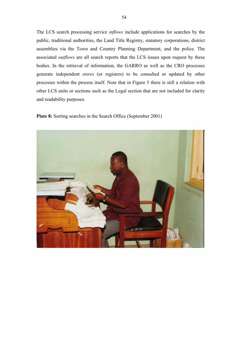
54
The LCS search processing service inflows include applications for searches by the
public, traditional authorities, the Land Title Registry, statutory corporations, district
assemblies via the Town and Country Planning Department, and the police. The
associated outflows are all search reports that the LCS issues upon request by these
bodies. In the retrieval of information, the GARRO as well as the CRO processes
generate independent stores (or registers) to be consulted or updated by other
processes within the process itself. Note that in Figure 5 there is still a relation with
other LCS units or sections such as the Legal section that are not included for clarity
and readability purposes.
Plate 8: Sorting searches in the Search Office (September 2001)
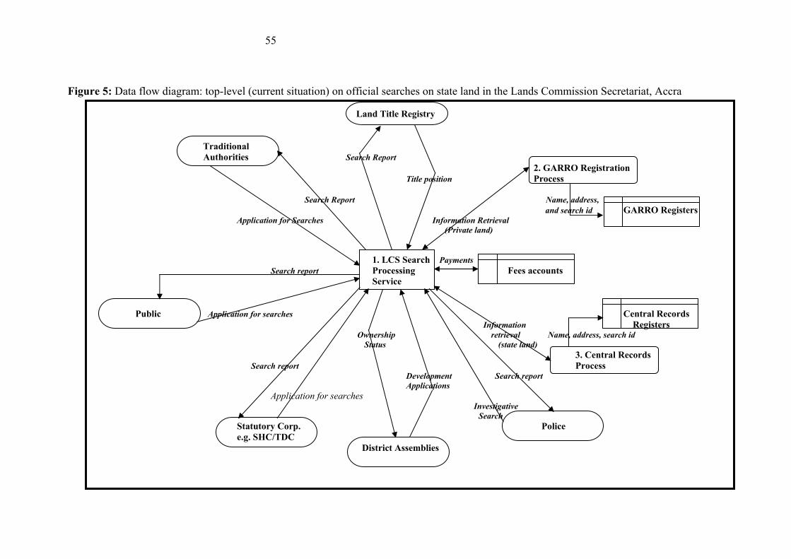
55
Figure 5: Data flow diagram: top-level (current situation) on official searches on state land in the Lands Commission Secretariat, Accra
Land Title Registry
Traditional
Authorities Search Report
2. GARRO Registration
Title position Process
Search Report Name, address,
and search id GARRO Registers Application for Searches Information Retrieval
(Private land)
1. LCS Search Payments
Search report Processing Fees accounts
Service
Public Application for searches Central Records
Information Registers Ownership retrieval Name, address, search id
Status (state land)
3. Central Records
Search report Process Development Search report
Applications
Application for searches Investigative
Search
Statutory Corp. Police
e.g. SHC/TDC
District Assemblies
56
6.1.4 Step Four: The �Searches� Level-One Diagram on State Land.
The top-level diagram is further zoomed in to the necessary level of detail while still
focusing on the area of interest to this research � the LCS search processing service.
This is referred to as a Level-one diagram (Figure 6). In this study, six processes are
identified: the search office registration process, the fees payment process, the
GARRO search process, the GARRO information retrieval process, the CRO search
process and the CRO information retrieval process.
It is to be noted that the Search Office registration process is now split into two,
distinguishing its primary function of seeing to the processing of these searches from
that of the (Accounts) fees payment process that generates a fee ledger (store). The
GARRO search process is restricted to the retrieval of information on private land
and generates incoming and outgoing registers. The CRO deals mainly with
information retrieval on state land, generates its own incoming and outgoing registers.
Reports from this section combine with reports from GARRO to provide complete
ownership information for the benefit of institutions and property owners. An
important element in the whole application process is the submission of the subject
site plans, the names and addresses of applicants and the payments of requisite fees.
The Search Office allocates search numbers (ids) for easy retrieval purposes. The
name, address and search id are used in the entire process. The output of the search
process is 1) site plans with LD (Lands Department) numbers and 2) associated
information retrieved from the LCS database.
To fully understand Figure 6, a meta database is needed. Boxes 2, 3 and 4 show data
dictionaries for each process, data flow and store. Bottlenecks in the process are also
determined. These processes, flows and stores that indicate the current search
situation, evolved through the study of the search process by the analyst(s) and
through subsequent discussions with the selected fifteen respondents involved in the
initial brainstorming session. The discussion took place during the validation session.
It meant reviewing most of the earlier work done by the analyst(s) in the validation
session. The analyst(s) for instance, forgot to include the courts in the whole process
and this could only be rectified through such a review.
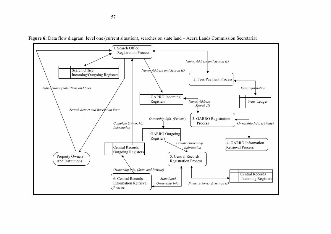
57
Figure 6: Data flow diagram: level one (current situation), searches on state land � Accra Lands Commission Secretariat
1. Search Office
Registration Process
Name, Address and Search ID
Search Office Name, Address and Search ID
Incoming/Outgoing Registers
2. Fees Payment Process
Submission of Site Plans and Fees Fees Information
GARRO Incoming
Registers Name, Address Fees Ledger Search ID
Search Report and Receipt on Fees
Ownership Info. (Private) 3. GARRO Registration
Complete Ownership Process Ownership Info. (Private) Information
GARRO Outgoing
Registers
Private Ownership 4. GARRO Information
Central Records Information Retrieval Process
Outgoing Registers
Property Owners 5. Central Records
And Institutions Registration Process
Ownership info. (State and Private)
Central Records
6. Central Records State Land Incoming Registers
Information Retrieval Ownership Info Name, Address & Search ID
Process
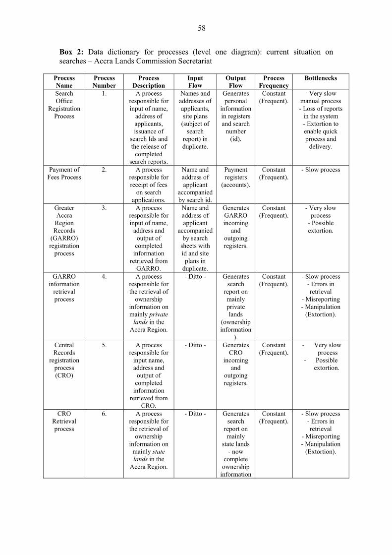
58
Box 2: Data dictionary for processes (level one diagram): current situation on
searches � Accra Lands Commission Secretariat
Process
Name
Process
Number
Process
Description
Input
Flow
Output
Flow
Process
Frequency
Bottlenecks
Search
Office
Registration
Process
1. A process
responsible for
input of name,
address of
applicants,
issuance of
search Ids and
the release of
completed
search reports.
Names and
addresses of
applicants,
site plans
(subject of
search
report) in
duplicate.
Generates
personal
information
in registers
and search
number
(id).
Constant
(Frequent).
- Very slow
manual process
- Loss of reports
in the system
- Extortion to
enable quick
process and
delivery.
Payment of
Fees Process
2. A process
responsible for
receipt of fees
on search
applications.
Name and
address of
applicant
accompanied
by search id.
Payment
registers
(accounts).
Constant
(Frequent).
- Slow process
Greater
Accra
Region
Records
(GARRO)
registration
process
3. A process
responsible for
input of name,
address and
output of
completed
information
retrieved from
GARRO.
Name and
address of
applicant
accompanied
by search
sheets with
id and site
plans in
duplicate.
Generates
GARRO
incoming
and
outgoing
registers.
Constant
(Frequent).
- Very slow
process
- Possible
extortion.
GARRO
information
retrieval
process
4. A process
responsible for
the retrieval of
ownership
information on
mainly private
lands in the
Accra Region.
- Ditto - Generates
search
report on
mainly
private
lands
(ownership
information
).
Constant
(Frequent).
- Slow process
- Errors in
retrieval
- Misreporting
- Manipulation
(Extortion).
Central
Records
registration
process
(CRO)
5. A process
responsible for
input name,
address and
output of
completed
information
retrieved from
CRO.
- Ditto - Generates
CRO
incoming
and
outgoing
registers.
Constant
(Frequent).
- Very slow
process
- Possible
extortion.
CRO
Retrieval
process
6. A process
responsible for
the retrieval of
ownership
information on
mainly state
lands in the
Accra Region.
- Ditto - Generates
search
report on
mainly
state lands
- now
complete
ownership
information
Constant
(Frequent).
- Slow process
- Errors in
retrieval
- Misreporting
- Manipulation
(Extortion).

59
Box 3: Data dictionary for data flows � level one diagram: current situation on
searches � Accra Lands Commission Secretariat
Data Name Data Description Data Type Used By
Processes
Bottlenecks Data
Source
Name,
Addresses and
Search numbers
(ids) and
associated site
plans
Personal data that
enables the
identification of
enquirer and search
# associated with
search report.
Alphanumeric. 1, 2,3,4,5
and 6.
Slow inflow
due to non-
adherence of
�first come first
served basis�
principle.
Search
registration
office.
Fees
information and
receipt on fees
Information on
Fees as identified
by receipts issued
upon payment
Alphanumeric. 2. - Ditto - Accounts
office
Ownership
Information
(private and
state land)
Data relating to site
plans as retrieved
from GARRO and
CRO respectively
and separately.
Alphanumeric. 1, 3, 4, 5, 6 - Very slow
retrieval
process and
error prone
- Manipulation
through
extortion
- May be
unreliable
- Untimely.
Records
sheets,
name and
property
registers at
GARRO
and CRO
Complete
Ownership
information
(Search Report)
Data retrieved from
both GARRO and
CRO and
combined for
release as search
reports
Alphanumeric. 1. - Quite slow
- Report can be
contentious on
grounds of
ambiguity and
errors
Records
sheets,
name and
property
registers at
GARRO
and CRO
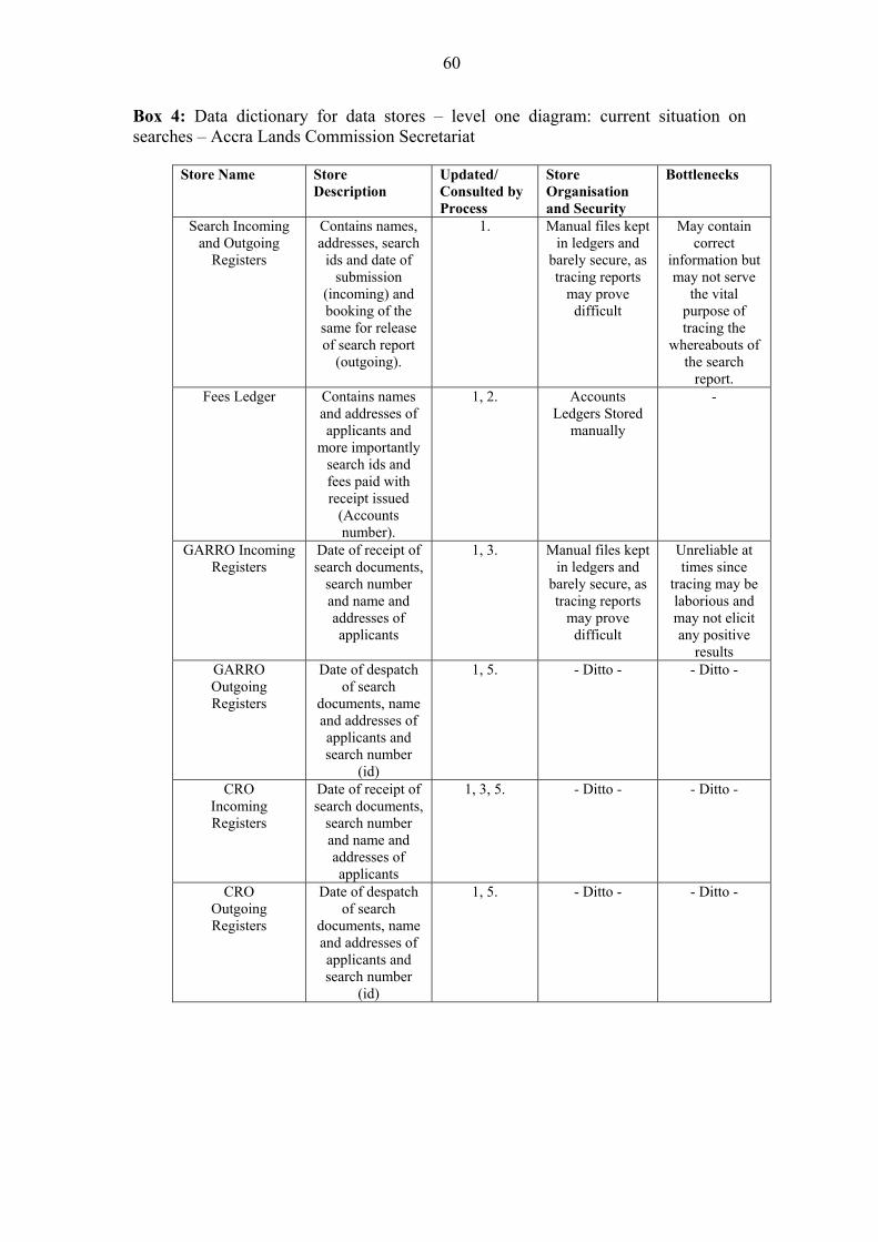
60
Box 4: Data dictionary for data stores � level one diagram: current situation on
searches � Accra Lands Commission Secretariat
Store Name Store
Description
Updated/
Consulted by
Process
Store
Organisation
and Security
Bottlenecks
Search Incoming
and Outgoing
Registers
Contains names,
addresses, search
ids and date of
submission
(incoming) and
booking of the
same for release
of search report
(outgoing).
1. Manual files kept
in ledgers and
barely secure, as
tracing reports
may prove
difficult
May contain
correct
information but
may not serve
the vital
purpose of
tracing the
whereabouts of
the search
report.
Fees Ledger Contains names
and addresses of
applicants and
more importantly
search ids and
fees paid with
receipt issued
(Accounts
number).
1, 2. Accounts
Ledgers Stored
manually
-
GARRO Incoming
Registers
Date of receipt of
search documents,
search number
and name and
addresses of
applicants
1, 3. Manual files kept
in ledgers and
barely secure, as
tracing reports
may prove
difficult
Unreliable at
times since
tracing may be
laborious and
may not elicit
any positive
results
GARRO
Outgoing
Registers
Date of despatch
of search
documents, name
and addresses of
applicants and
search number
(id)
1, 5. - Ditto - - Ditto -
CRO
Incoming
Registers
Date of receipt of
search documents,
search number
and name and
addresses of
applicants
1, 3, 5. - Ditto - - Ditto -
CRO
Outgoing
Registers
Date of despatch
of search
documents, name
and addresses of
applicants and
search number
(id)
1, 5. - Ditto - - Ditto -
61
We have to examine the level-one diagram (Figure 6) to determine whether a new
design cannot be made to improve the current search process. There are a number of
issues raised by the current process:
The manual system of registration and the forwarding system can, through human
error, lead to the loss or misplacement of search reports.
Retrieval of information could take a very long time as this is done manually and
is not based on a �first come, first serve basis�. Most applicants have quick search
reports after payments of unofficial fees to staff10
whilst those who �trust the
system� may have to wait for well over four to six weeks sometimes even months
to receive their reports.
Wrong dissemination of information cannot be ruled out. It is possible for
investors to base decisions on the LCS search report only to realise that the reports
were either incomplete or wrong. Some of these investors had had problems with
the banks that had conducted independent searches on the same piece of land but
had been given conflicting reports.
Duplication occurs. For instance there is no reason for a search being conducted
should go to two places (GARRO and CRO). The fact that any search must of
necessity be channelled through the GARRO office as well involves duplication
of efforts at certain times.
These are general problems that are encountered but technically we need to detect and
correct errors successfully. Identifying the requirement errors avoids re-working and
improves the quality and productivity of systems development. Several requirement
verification techniques exist aimed at detecting errors in systems specifications. These
include simulation, reviews, data flow diagram algebra, walkthroughs, inspections
and prototyping. Instead of explaining all these techniques and showing what they
could do, focus will be placed on the choice of this research, prototyping.
It is important to state, however that, no technique can provide a comprehensive
verification, and therefore an approach may, within certain constraints, integrate more
techniques to provide adequate verification (Sakthivel, 1991). In this research, in
10
Such private arrangements between the public and staff are common and it is a
cause for concern.
62
order to afford adequate verification, validation and review sessions with middle line
management, are held in addition to the prototyping technique.
Prototyping will help in the identification of certain types of technical errors in the
search process itself that include incomplete requirement errors and some errors
associated with inconsistencies. Incomplete requirement errors identified with the
current search process include process insufficiency and data insufficiency. The
former is defined as a process defined insufficiently such that its specified input does
not match specified output (Sakthivel, 1991). For example, the site plan submitted
(input) should elicit correct information from the search database. However, more
often than not, the retrieval process produces reports (output) that may be wrong due
to a number of reasons that include wrong site plans emanating out of wrong survey
work, wrong placement of grid values (or co-ordinates) and human error. Data
insufficiency refers to the non-availability of all the data required for performing a
process (Sakthivel, 1991). For example, technical officers are often confronted with
data on different sheets that they are required to collate. These sheets sometimes
cannot be traced, yet reports are sometimes released all the same! External
inconsistencies refer to the conflict of specification with the systems goals and
objectives. For example, the objective of the LCS search office is to give accurate and
up to date information on its database. This requirement is normally not met as some
manipulations of this database leading to wrong dissemination of information has
sometimes been detected defeating the very goal the LCS has set itself. The database
itself is not sufficiently updated.
The implications of the above for GIS system design are that information requirement
errors are likely to be a major source of the system�s deficiencies. For prototyping,
this potential error becomes less pronounced. The methodology forces the system
developer to respond to the users� identification of deficiencies in information
requirements (Braunstein et al. 1991). What is to be done to have such an improved
system? The next section examines the future proposed situation.
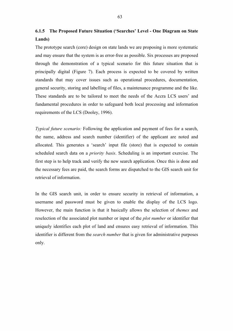
63
6.1.5 The Proposed Future Situation (�Searches� Level - One Diagram on State
Lands)
The prototype search (core) design on state lands we are proposing is more systematic
and may ensure that the system is as error-free as possible. Six processes are proposed
through the demonstration of a typical scenario for this future situation that is
principally digital (Figure 7). Each process is expected to be covered by written
standards that may cover issues such as operational procedures, documentation,
general security, storing and labelling of files, a maintenance programme and the like.
These standards are to be tailored to meet the needs of the Accra LCS users� and
fundamental procedures in order to safeguard both local processing and information
requirements of the LCS (Dooley, 1996).
Typical future scenario: Following the application and payment of fees for a search,
the name, address and search number (identifier) of the applicant are noted and
allocated. This generates a �search� input file (store) that is expected to contain
scheduled search data on a priority basis. Scheduling is an important exercise. The
first step is to help track and verify the new search application. Once this is done and
the necessary fees are paid, the search forms are dispatched to the GIS search unit for
retrieval of information.
In the GIS search unit, in order to ensure security in retrieval of information, a
username and password must be given to enable the display of the LCS logo.
However, the main function is that it basically allows the selection of themes and
reselection of the associated plot number or input of the plot number or identifier that
uniquely identifies each plot of land and ensures easy retrieval of information. This
identifier is different from the search number that is given for administrative purposes
only.
64
Figure 7: Data flow diagram for official searches on state land: level one (future situation) � Accra Lands Commission Secretariat
Scheduled Search data
1.1Search Input,
Output Processing
Search Input files
Plot ID
Completed Search Report Retrieval for Output 1.2 Input of Plot ID 1
Process 2
Application for Search
and payment of fees Search Output Files
Zoomed-in & highlighted site plan
Complete and Validated Search Report Plot ID
Site Plans 1.3 Print Site Plans
Process
Property Owners
And Institutions
1.6 GIS Unit Review
Process Ownership Info 1.4 Databases retrieval
Records Master file Process
Search Report Ownership Information
1.5 Print associated
Search report process
65
Retrieval occurs at two fronts (stages 1 and 2 in Figure 7). The first step will involve
the printing of zoomed-in and highlighted and labelled site plans in ArcView 3.2 that
is provided for the attention of the GIS Review Unit. The second step will involve the
retrieval of information from the master file (LandsCommissionDatabases) in Access
that also ends up at the GIS Review Unit. The role of this unit is, among other things,
to collaborate with the Inspectorate Division of the LCS in order to re-check
information on properties on the ground. This is for updating purposes only. Is there a
change of user or address? Have any covenants been breached? This is a necessary
step towards validation. In this case, the Inspectorate Division of the LCS should be
fully �resourced� and made vibrant in their operations. The complete and validated
search report (site plans and attribute information on ownership) is then recorded in
the search output files for onward transmission to the applicant. It is to be noted that
retrieval occurs from one main database or different databases in one unit and at the
same location and not two different units/locations as previously. The advantage of
this future situation is that searches are done very quickly and since validation is a
necessary ingredient, are also as error-free as possible. The suggested design is
incorporated in the final user interface design.
It is useful to recapitulate on what this research has so far achieved before the design
of the Accra LCS GIS prototype and its associated user interface is described in the
next section of part two. The study of key users� needs, the structure and processes of
the Accra LCS have helped to reduce any differences that may exist between actual
and perceived requirements in that organisation (Yadav, 1983). Two approaches have
evolved as a result � the CSF as a primary information requirement methodology in
determining the Accra LCS performance needs and the DFA as a secondary
methodology in determining the Accra LCS functional needs. Both are used (as
already indicated) as methods of information requirement analysis at the
organisational and application levels. Neither method is used as a verification
technique in itself. To eliminate inconsistencies, incorrectness and possible
ambiguities, the prototyping methodology is used on the LCS actual system at the
application level. The use of the method is based on the following:
1. as a specification verification technique; and
2. as the design of the system itself (this will involve formal specifications of
requirements).
66
This section of the paper describes the prototype software system (�LandAdmin�) that
has been developed using ArcView 3.2, the Avenue scripting language, and
Microsoft�s Access database, to handle routine land administration tasks. The design
of quick maps for field inspections, of site plans to be incorporated in leases, map
compositions, of lessees general and billing information, rent demand notices and
searches, personnel and secretariat information, clients address lists, rent position and
rent demand notices on state land et cetera are covered. We accept the fact that the
selection of a proper project design is central to the Accra LCS successful GIS project
implementation. The design of this software is both technically sound and
appropriate, given the socio-economic environment of the intended beneficiaries.
Careful attention had to be given to tasks normally performed by the LCS, with the
view of having a user-friendly interface that is menu driven and that truly represents
the LCS work processes, while placing this within the requisite institutional
arrangements of the secretariat. This research therefore, had as a primary objective of
designing a system that was to be optimally operational and that will be delivered to
the LCS as part of its pilot project with the full participation of the users themselves
from the very beginning. In this design, therefore, the bottom line is practicality.
The first fieldwork (July to September 2001) apart from releasing the prototype
software using Arc View to six selected respondents for general testing, also afforded
the chance to study the use of Access by the Accra LCS as a database management
tool. Suggestions that were made with inputs from the present actual users (two in
number as at end of September 2001) enabled the development of the Access
interface. Testing of this design on a wider scale involving the six respondents is
expected to undergo further testing. It is to be noted that GERMP had helped in the
choice of software that includes Arc/Info that runs on PC and Unix systems, ArcView
and Microsoft Access databases (Plate 9). The Accra LCS is at the moment using
Access in its normal work processes albeit on a very minor scale (for only rent
management).
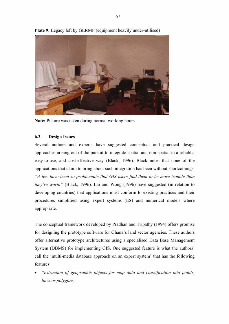
67
Plate 9: Legacy left by GERMP (equipment heavily under-utilised)
Note: Picture was taken during normal working hours
6.2 Design Issues
Several authors and experts have suggested conceptual and practical design
approaches arising out of the pursuit to integrate spatial and non-spatial in a reliable,
easy-to-use, and cost-effective way (Black, 1996). Black notes that none of the
applications that claim to bring about such integration has been without shortcomings.
�A few have been so problematic that GIS users find them to be more trouble than
they�re worth� (Black, 1996). Lai and Wong (1996) have suggested (in relation to
developing countries) that applications must conform to existing practices and their
procedures simplified using expert systems (ES) and numerical models where
appropriate.
The conceptual framework developed by Pradhan and Tripathy (1994) offers promise
for designing the prototype software for Ghana�s land sector agencies. These authors
offer alternative prototype architectures using a specialised Data Base Management
System (DBMS) for implementing GIS. One suggested feature is what the authors�
call the �multi-media database approach on an expert system� that has the following
features:
• �extraction of geographic objects for map data and classification into points,
lines or polygons;
68
• storage of the above in a relational database11
;
• unstructured background graphics and image are retained in their individual
databases; and where KBS is used12
• the KBS becomes the top layer of the system that serves as an intelligent interface
between the user and the data� (Pradhan and Tripathy, 1994).
Such a system maintains complete database integrity through the simple concept that
the spatial location of a particular feature can be considered as simply another
attribute of that feature. Derived from this concept, both graphic and descriptive
attributes are associated as a single record of a particular feature.
11
Or object-oriented database as the case may be 12
Knowledge Base Systems (KBS) are not explored in this work as no attempt is
made to solve ill-structured problems associated with this system.
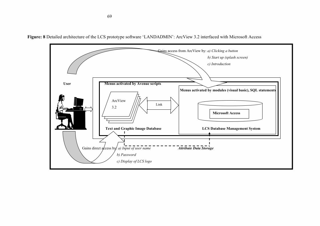
69
Figure: 8 Detailed architecture of the LCS prototype software �LANDADMIN�: ArcView 3.2 interfaced with Microsoft Access
Gains access from ArcView by: a) Clicking a button
b) Start up (splash screen)
c) Introduction
User Menus activated by Avenue scripts
Menus activated by modules (visual basic), SQL statements
Text and Graphic Image Database LCS Database Management System
Microsoft Access
ArcView
3.2 Link
Gains direct access by: a) Input of user name Attribute Data Storage
b) Password
c) Display of LCS logo
70
The use of this concept is influenced by the actual situation in the Accra LCS. The
LCS has gone ahead to use Access (DBMS) separately with the aim of capturing
attribute data and ensuring efficient management of its database with little or no
parallel development of ArcView (GIS). The proper use of GIS will offer a better
organisation of the parcel data the LCS uses and add the dimension of geo-referencing
to the available data. The two systems are not linked and therefore are not being used
together.
The observation by Huxhold (1991) is a very apt description of the Accra LCS
situation. He has noted that one of the most accepted blunders about GIS is that non-
graphics data from the organisation�s administrative data bases must exist on the GIS
with the base map information. �The problem with this concept is that many local
governments have already implemented information systems on existing computers to
support their nongraphics data needs�Some of these systems may have been
operating successfully for many years, and to abandon them in order to implement
them on a new GIS would not only disrupt daily operations, but also create additional
cost that may not be necessary�.
Figure 8 shows the architecture of the prototype software based on the above
principles. Conceptually13
, it takes the complete text database in ArcView and stores
them as attribute data in the Access database using the �plot number� as the unique
identifier. ArcView extracts geographic objects from the parcel data and classifies
them into points, lines or polygons and displays them as maps etc as specified by the
user. The geometric relationship between points, lines and areas in the structured layer
are combined with other data such as names, addresses etc., in the Access Database to
ensure efficient management of the database.
The communication medium between ArcView and the Access database is by
executing system request commands through Avenue scripts in ArcView. This allows
ArcView to exit temporarily to perform functions and operations of Access. Since this
is a link, minimising the Access interface enables the user to interactively use both
13
In practice, however, the area and perimeter generated by ArcView is discarded in
the Access database as they are of no practical use.
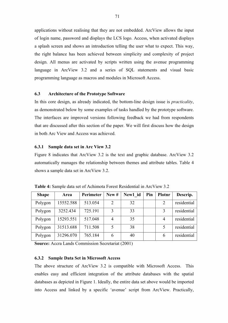
71
applications without realising that they are not embedded. ArcView allows the input
of login name, password and displays the LCS logo. Access, when activated displays
a splash screen and shows an introduction telling the user what to expect. This way,
the right balance has been achieved between simplicity and complexity of project
design. All menus are activated by scripts written using the avenue programming
language in ArcView 3.2 and a series of SQL statements and visual basic
programming language as macros and modules in Microsoft Access.
6.3 Architecture of the Prototype Software
In this core design, as already indicated, the bottom-line design issue is practicality,
as demonstrated below by some examples of tasks handled by the prototype software.
The interfaces are improved versions following feedback we had from respondents
that are discussed after this section of the paper. We will first discuss how the design
in both Arc View and Access was achieved.
6.3.1 Sample data set in Arc View 3.2
Figure 8 indicates that ArcView 3.2 is the text and graphic database. ArcView 3.2
automatically manages the relationship between themes and attribute tables. Table 4
shows a sample data set in ArcView 3.2.
Table 4: Sample data set of Achimota Forest Residential in ArcView 3.2
Shape Area Perimeter New # New1_id Pin Plotnr Descrip.
Polygon 15552.588 513.054 2 32 2 residential
Polygon 3252.434 725.191 3 33 3 residential
Polygon 15293.551 517.048 4 35 4 residential
Polygon 31513.688 711.508 5 38 5 residential
Polygon 31296.070 765.184 6 40 6 residential
Source: Accra Lands Commission Secretariat (2001)
6.3.2 Sample Data Set in Microsoft Access
The above structure of ArcView 3.2 is compatible with Microsoft Access. This
enables easy and efficient integration of the attribute databases with the spatial
databases as depicted in Figure 1. Ideally, the entire data set above would be imported
into Access and linked by a specific �avenue� script from ArcView. Practically,
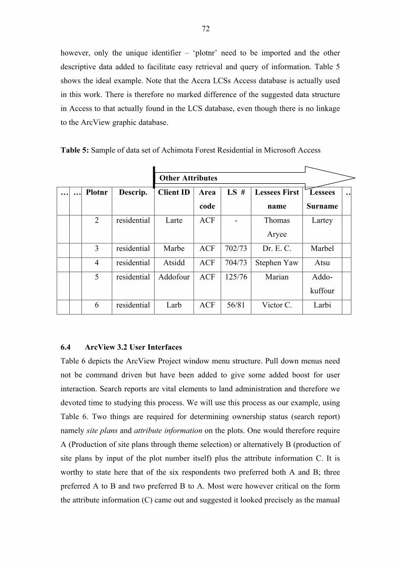
72
however, only the unique identifier � �plotnr� need to be imported and the other
descriptive data added to facilitate easy retrieval and query of information. Table 5
shows the ideal example. Note that the Accra LCSs Access database is actually used
in this work. There is therefore no marked difference of the suggested data structure
in Access to that actually found in the LCS database, even though there is no linkage
to the ArcView graphic database.
Table 5: Sample of data set of Achimota Forest Residential in Microsoft Access
Other Attributes
� � Plotnr Descrip. Client ID Area
code
LS # Lessees First
name
Lessees
Surname
�
2 residential Larte ACF - Thomas
Aryee
Lartey
3 residential Marbe ACF 702/73 Dr. E. C. Marbel
4 residential Atsidd ACF 704/73 Stephen Yaw Atsu
5 residential Addofour ACF 125/76 Marian Addo-
kuffour
6 residential Larb ACF 56/81 Victor C. Larbi
6.4 ArcView 3.2 User Interfaces
Table 6 depicts the ArcView Project window menu structure. Pull down menus need
not be command driven but have been added to give some added boost for user
interaction. Search reports are vital elements to land administration and therefore we
devoted time to studying this process. We will use this process as our example, using
Table 6. Two things are required for determining ownership status (search report)
namely site plans and attribute information on the plots. One would therefore require
A (Production of site plans through theme selection) or alternatively B (production of
site plans by input of the plot number itself) plus the attribute information C. It is
worthy to state here that of the six respondents two preferred both A and B; three
preferred A to B and two preferred B to A. Most were however critical on the form
the attribute information (C) came out and suggested it looked precisely as the manual
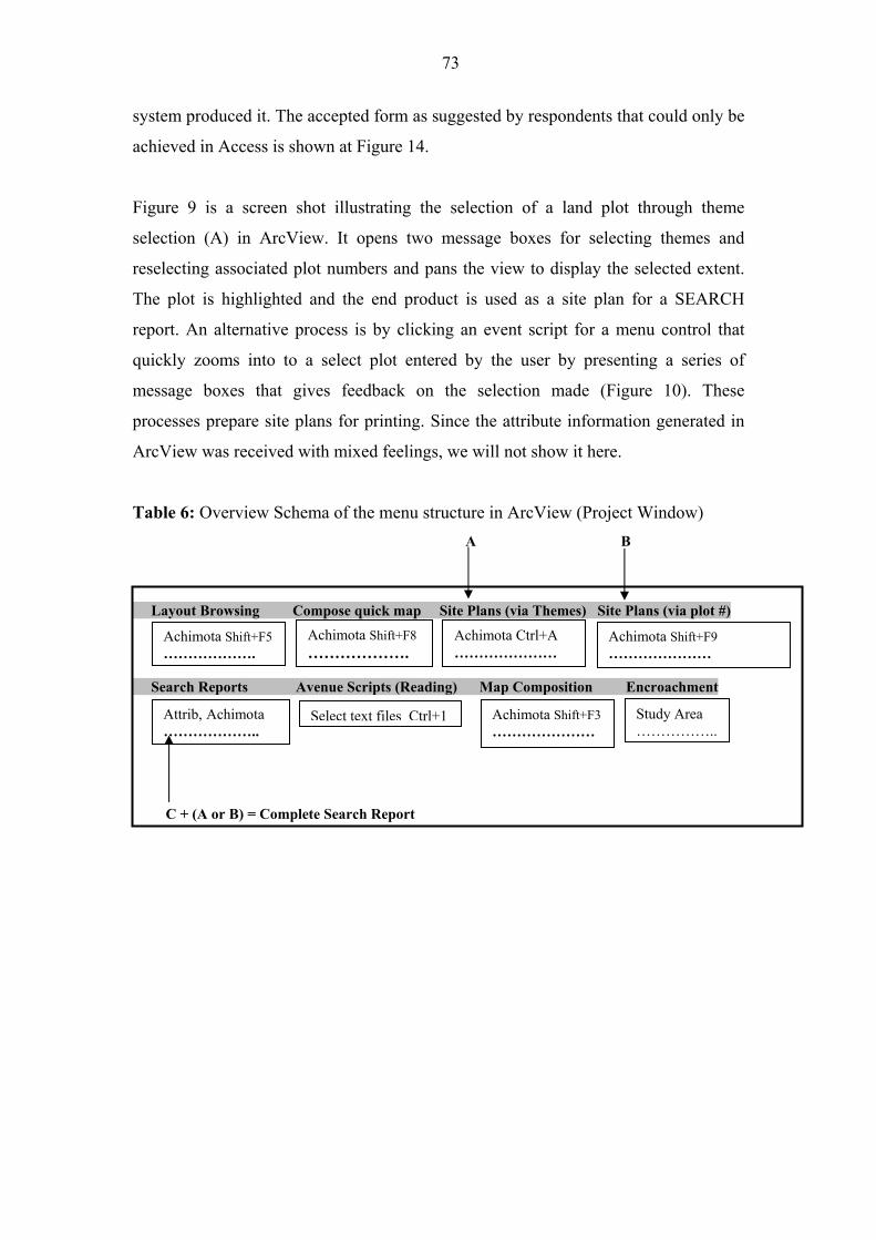
73
system produced it. The accepted form as suggested by respondents that could only be
achieved in Access is shown at Figure 14.
Figure 9 is a screen shot illustrating the selection of a land plot through theme
selection (A) in ArcView. It opens two message boxes for selecting themes and
reselecting associated plot numbers and pans the view to display the selected extent.
The plot is highlighted and the end product is used as a site plan for a SEARCH
report. An alternative process is by clicking an event script for a menu control that
quickly zooms into to a select plot entered by the user by presenting a series of
message boxes that gives feedback on the selection made (Figure 10). These
processes prepare site plans for printing. Since the attribute information generated in
ArcView was received with mixed feelings, we will not show it here.
Table 6: Overview Schema of the menu structure in ArcView (Project Window)
A B
Layout Browsing Compose quick map Site Plans (via Themes) Site Plans (via plot #)
Achimota Shift+F8
������.Achimota Ctrl+A
������� Achimota Shift+F5
������.
Achimota Shift+F9
�������
Search Reports Avenue Scripts (Reading) Map Composition Encroachment
Attrib, Achimota
������..
Study Area
�����.. Achimota Shift+F3
������� Select text files Ctrl+1
C + (A or B) = Complete Search Report
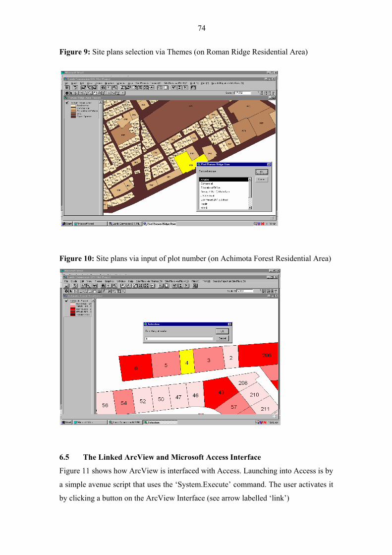
74
Figure 9: Site plans selection via Themes (on Roman Ridge Residential Area)
Figure 10: Site plans via input of plot number (on Achimota Forest Residential Area)
6.5 The Linked ArcView and Microsoft Access Interface
Figure 11 shows how ArcView is interfaced with Access. Launching into Access is by
a simple avenue script that uses the �System.Execute� command. The user activates it
by clicking a button on the ArcView Interface (see arrow labelled �link�)
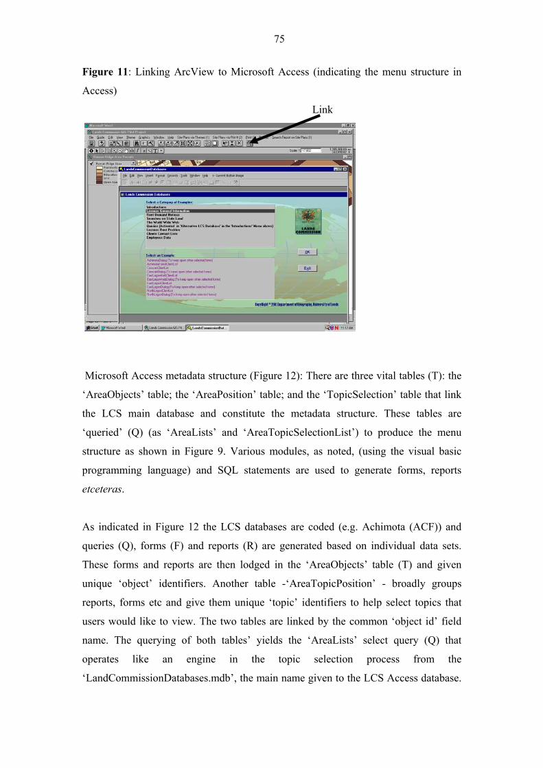
75
Figure 11: Linking ArcView to Microsoft Access (indicating the menu structure in
Access)
Link
Microsoft Access metadata structure (Figure 12): There are three vital tables (T): the
�AreaObjects� table; the �AreaPosition� table; and the �TopicSelection� table that link
the LCS main database and constitute the metadata structure. These tables are
�queried� (Q) (as �AreaLists� and �AreaTopicSelectionList�) to produce the menu
structure as shown in Figure 9. Various modules, as noted, (using the visual basic
programming language) and SQL statements are used to generate forms, reports
etceteras.
As indicated in Figure 12 the LCS databases are coded (e.g. Achimota (ACF)) and
queries (Q), forms (F) and reports (R) are generated based on individual data sets.
These forms and reports are then lodged in the �AreaObjects� table (T) and given
unique �object� identifiers. Another table -�AreaTopicPosition� - broadly groups
reports, forms etc and give them unique �topic� identifiers to help select topics that
users would like to view. The two tables are linked by the common �object id� field
name. The querying of both tables� yields the �AreaLists� select query (Q) that
operates like an engine in the topic selection process from the
�LandCommissionDatabases.mdb�, the main name given to the LCS Access database.

76
The �AreaTopicPosition� is queried separately to generate the �AreaTopic Selection�
select query (Q). What happens then is that the user clicks a general topic on the
�LandsCommissionDatabases� user interface and gets a pull down menu with
alternatives to select from (Figure 11). Let us now look at some examples of the
Access user interface.
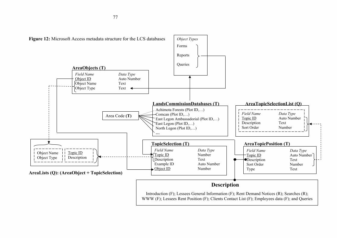
77
Figure 12: Microsoft Access metadata structure for the LCS databases
AreaObjects (T)
LandsCommissionDatabases (T) AreaTopicSelectionList (Q)
AreaTopicSelectionList (Q)
TopicSelection (T) AreaTopicPosition (T)
AreaLists (Q): (AreaObject + TopicSelection)
Achimota Forests (Plot ID,�)
Comcan (Plot ID,�)
East Legon Ambassadorial (Plot ID,�)
East Legon (Plot ID,�)
North Legon (Plot ID,�)
�
Field Name Data Type
Object ID Auto Number
Object Name Text
Object Type Text
Field Name Data Type
Topic ID Auto Number
Description Text
Sort Order Number
Type Text
Field Name Data Type
Topic ID Number
Description Text
Example ID Auto Number
Object ID Number
Area Code (T) Field Name Data Type
Topic ID Auto Number
Description Text
Sort Order Number
Object Name
Object Type
Topic ID
Description
Object Types
Forms
Reports
Queries
Description
Introduction (F); Lessees General Information (F); Rent Demand Notices (R); Searches (R);
WWW (F); Lessees Rent Position (F); Clients Contact List (F); Employees data (F); and Queries
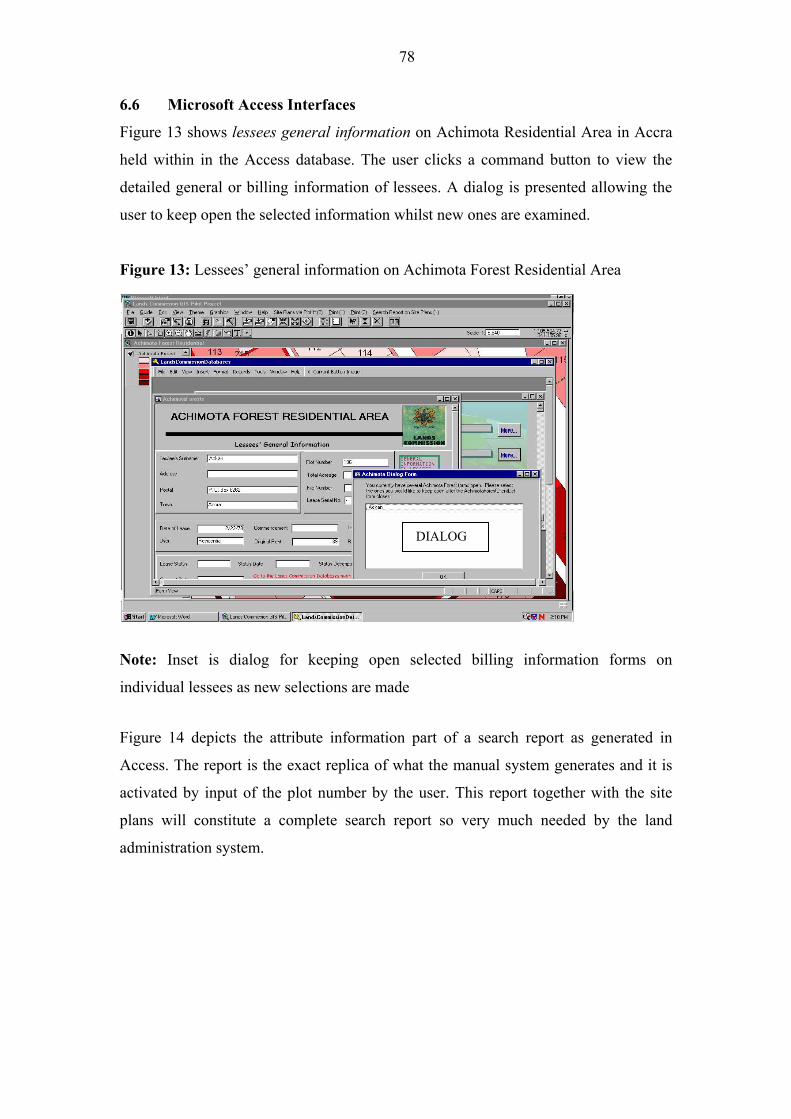
78
6.6 Microsoft Access Interfaces
Figure 13 shows lessees general information on Achimota Residential Area in Accra
held within in the Access database. The user clicks a command button to view the
detailed general or billing information of lessees. A dialog is presented allowing the
user to keep open the selected information whilst new ones are examined.
Figure 13: Lessees� general information on Achimota Forest Residential Area
DIALOG
Note: Inset is dialog for keeping open selected billing information forms on
individual lessees as new selections are made
Figure 14 depicts the attribute information part of a search report as generated in
Access. The report is the exact replica of what the manual system generates and it is
activated by input of the plot number by the user. This report together with the site
plans will constitute a complete search report so very much needed by the land
administration system.
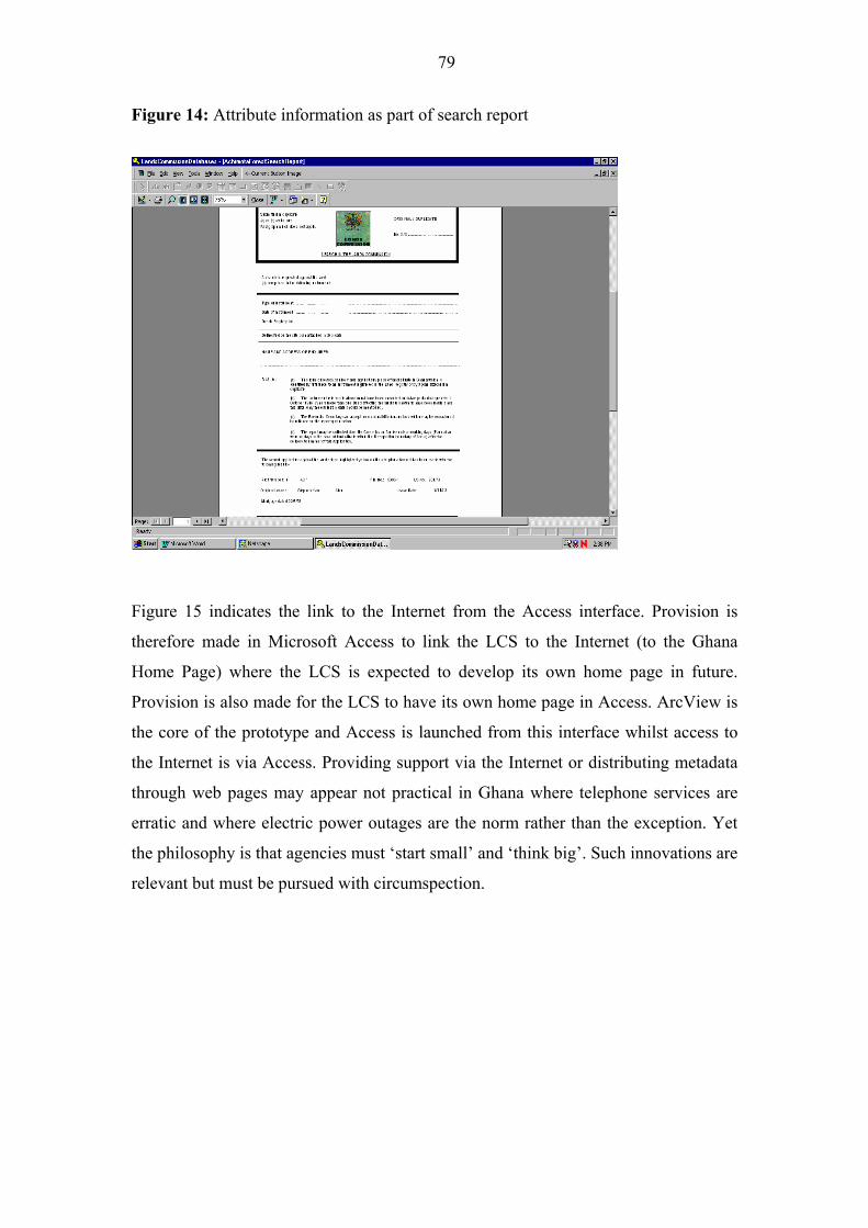
79
Figure 14: Attribute information as part of search report
Figure 15 indicates the link to the Internet from the Access interface. Provision is
therefore made in Microsoft Access to link the LCS to the Internet (to the Ghana
Home Page) where the LCS is expected to develop its own home page in future.
Provision is also made for the LCS to have its own home page in Access. ArcView is
the core of the prototype and Access is launched from this interface whilst access to
the Internet is via Access. Providing support via the Internet or distributing metadata
through web pages may appear not practical in Ghana where telephone services are
erratic and where electric power outages are the norm rather than the exception. Yet
the philosophy is that agencies must �start small� and �think big�. Such innovations are
relevant but must be pursued with circumspection.
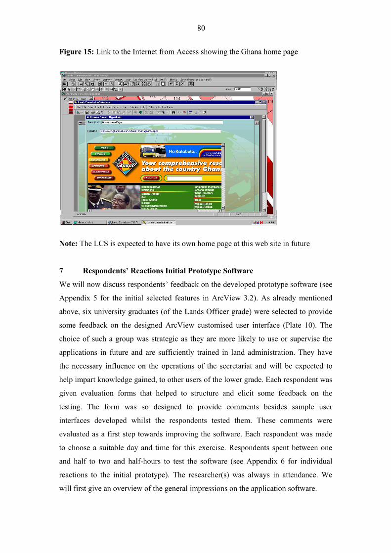
80
Figure 15: Link to the Internet from Access showing the Ghana home page
Note: The LCS is expected to have its own home page at this web site in future
7 Respondents� Reactions Initial Prototype Software
We will now discuss respondents� feedback on the developed prototype software (see
Appendix 5 for the initial selected features in ArcView 3.2). As already mentioned
above, six university graduates (of the Lands Officer grade) were selected to provide
some feedback on the designed ArcView customised user interface (Plate 10). The
choice of such a group was strategic as they are more likely to use or supervise the
applications in future and are sufficiently trained in land administration. They have
the necessary influence on the operations of the secretariat and will be expected to
help impart knowledge gained, to other users of the lower grade. Each respondent was
given evaluation forms that helped to structure and elicit some feedback on the
testing. The form was so designed to provide comments besides sample user
interfaces developed whilst the respondents tested them. These comments were
evaluated as a first step towards improving the software. Each respondent was made
to choose a suitable day and time for this exercise. Respondents spent between one
and half to two and half-hours to test the software (see Appendix 6 for individual
reactions to the initial prototype). The researcher(s) was always in attendance. We
will first give an overview of the general impressions on the application software.
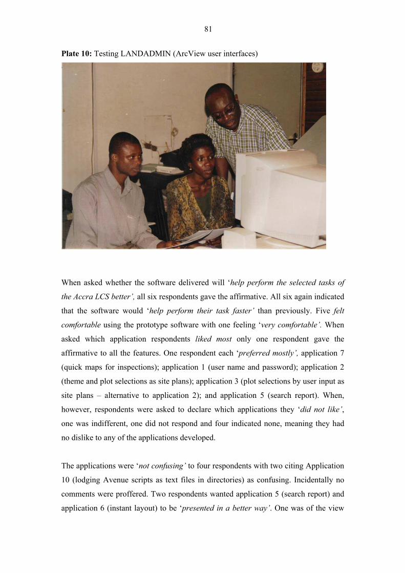
81
Plate 10: Testing LANDADMIN (ArcView user interfaces)
When asked whether the software delivered will �help perform the selected tasks of
the Accra LCS better�, all six respondents gave the affirmative. All six again indicated
that the software would �help perform their task faster� than previously. Five felt
comfortable using the prototype software with one feeling �very comfortable�. When
asked which application respondents liked most only one respondent gave the
affirmative to all the features. One respondent each �preferred mostly�, application 7
(quick maps for inspections); application 1 (user name and password); application 2
(theme and plot selections as site plans); application 3 (plot selections by user input as
site plans � alternative to application 2); and application 5 (search report). When,
however, respondents were asked to declare which applications they �did not like�,
one was indifferent, one did not respond and four indicated none, meaning they had
no dislike to any of the applications developed.
The applications were �not confusing� to four respondents with two citing Application
10 (lodging Avenue scripts as text files in directories) as confusing. Incidentally no
comments were proffered. Two respondents wanted application 5 (search report) and
application 6 (instant layout) to be �presented in a better way�. One was of the view
82
that the search report could be presented in a form that would be �easily and
attractively readable�. Another was of the opinion that the layouts should be in
landscape form and the site plans should indicate the acreage, cadastral plan number
and the name of the area as a caption. Three thought the application could be
�improved� with an equal number indicating their tacit acceptance of the applications
as they stood. None �rejected� the applications.
Questions such as �what applications do you want added in future� were added in the
questionnaire to help, if necessary, in the expansion of the application to cover other
areas. One view was that �rent management� in government residential areas was a
priority and ought to feature in such prototype software. Another wanted an
application that would �automatically calculate ground rents�, one to �list all lessees
in arrears for a given period� and an application for the processing of documents �so
that an applicant can actually trace his/her documents after it had been presented�.
This exercise strengthened our belief that potential users must be involved in the
design and implementation of GIS from the very beginning so they have a feeling of
ownership of the system. Such views can be identified and accommodated by
involving users in the design process itself. It is proven that system development that
does not involve user participation has mixed adoption rates (Cavaye and Cragg,
1993). Systems built in reaction to needs expressed by users are adopted more quickly
than systems built in the absence of expressed need. �The link between organisational
culture and implementation emphasises that change cannot be effectively introduced
if it is imposed or controlled. GIS implementation would involve much more subtle
processes of nurturing and cajoling change� (Campbell and Masser, 1995).
Land use changes occur frequently and it is recognised that the functionality of GIS
need not be restricted to static displays. It is our intention that later versions of the
software facilitate the representation and modelling of phenomena such as
encroachments on public land, a major issue in land management in Ghana, as a
mechanism for advising Government decision-making. Data on encroachments will
need to be collected and combined within the GIS to show their spatial extent and
their location in relation to other properties and infrastructure. The system would
allow vulnerable structures to be identified and earmarked for immediate demolition.
83
8 Conclusions
It is important that organisations in the lands sector contemplating GIS use consider
the general definition of what GIS is (database, analysis and visualisation) in terms of
what functions these systems may have within the specific agency and within its
broader social context. Individual perceptions of the nature and utility of the
�particular technology is likely to vary considerably according to personal,
organisational and cultural circumstances� (Campbell and Masser, 1995). The
ability for GIS to do spatial analysis gives it geo-spatial prowess and distinguishes it
from Computer Assisted Design (CAD) systems that are more suited for design and
presentation. In the case of land sector organisations, any definition that emphasises
the institutional aspect, yet deals with the technical aspects as well, is seen as generic
and therefore suitable for adoption.
Much reported research has either been �anecdotally based� (research not conducted
under controlled conditions) or centred on retrospective single case studies of
successful implementations. There is little by way of research to show the use of
empirical methods in a more systematic study of GIS/LIS diffusion in developing
countries. �Much could be learned from prospective studies as new classes of users
learn about the potential application of these tools to their fields�. This work
recommends a procedure of study aimed at examining prospective process of
adoption� (Onsrud and Pinto, 1991).
There are fundamental similarities between GIS/LIS and information science (IS) or
information technology (IT). To be able to develop an acceptable theoretical
framework for GIS/LIS diffusion, the state of the art in IS or IT or even information
management (IM) would have to be employed. There are different types of
methodologies that lend themselves to GIS research. Whilst the choice of methods
may be critical, the review of literature suggests a suite of methods or an eclectic
approach to the selection of these methods. No one method is most appropriate for
studying a broad or complex research problem. Each method or combinations of
methods have �advantages and disadvantages as well as different assumption biases
and degrees of usefulness� (Williamson et al., 1998). A common approach is to use
several research methods that compensate for each other�s weaknesses. Such
84
methodologies should cover both performance and functional needs of the
organisation and must be applied under an acceptable conceptual framework.
There is general agreement on the fact that major problems to be overcome in
improving land information practices in developing countries are organisational,
managerial and human based. �It is the manner in which the responsibility for land
data is allocated and distributed between institutions, how records are maintained
and administered and the experience and education of the people who run these
systems that determine their success and failure, not the technology used� (Zwart,
1990; Taylor, 1991). It is clear that GIS technology is a �western artefact�. Any
wholesale �diffusion� of this tool therefore without critical analysis and without
considering the socio-economic and institutional background of developing countries
may be a counter-productive approach. Such critical analysis should include
awareness creation among users and feasibility studies including a pilot project
preceded by prototype software development. It should also include learning from the
past, development of systems required, project proposal, systems testing and
evaluation, start-up and finally systems operation and review tailored to specific
agencies.
GIS installations in developing countries have mostly been donor designed and
implemented exclusively by consultants. Governments are now demanding and
receiving more control over project design and implementation. Ironically, the
literature suggests that there is still lack of experience of experts from developing
countries on the GIS/LIS diffusion processes and models for such countries. The
development of new models and the refinement of existing ones to suit these countries
are therefore necessary. Whilst in many countries there appears to be a �hoarding of
information� and therefore little information exchange, effective project design should
look at arrangements for data and information sharing. User needs assessment and
training are also critical in the design process. Participation by NGOs and the private
sector (as the engine of growth) in the use and production of geographic information
must be encouraged.
Ghanaians have a strong attachment to land. The need to establish and develop GIS
and networks among related land agencies and to encourage internal co-operation and
85
support in all aspects of land policy and administration engages the attention of the
Government. Along with this increased awareness has come a heightened awareness
of the difficulties that often exist in trying to introduce GIS within land sector
organisations in Ghana. The successful implementation of GIS to support land
administration in the lands sector in Ghana is confronted with a series of challenges
including the need: to provide frameworks within which GIS can evolve as a tool in
an orderly way in the LSAs; to find ways to democratise GIS in land administration
and management systems and structures within Ghana; to generate designs that are
innovative and practical so they will meet specific land sector needs; and to provide
support infrastructure and services that will enable GIS to operate effectively and
efficiently in the lands sector. Research should relate to an understanding of not only
the technical problems inherent in constructing GIS applications but also of the socio-
economic and political context within which GIS is to be adopted. This work has
examined a prospective process of GIS adoption by using a variety of fieldwork
methods to identify the needs of the LCS as well as those factors deemed by existing
staff to be critical if GIS implementation is to be successful. This paper has also
outlined the development of the prototype software that will provide a system for
much improved administration of routine land management tasks in the LCS, as well
as offering the opportunity to undertake very useful monitoring of encroachments.
86
References
Acquaye and Associates (1989) Study of Institutional-Legal problems associated with
land delivery, Final report, Accra, Government of Ghana, UNDP and United
Nations Centre for Human Settlements (HABITAT).
Asigbetse, W. (1986) Records Management at the Lands Commission Secretariat,
Unpublished Diploma Dissertation, University Of Ghana, Legon, Accra.
Avison, D. and Wood-Harper, A.T. (1990) Multiview: An Exploration in Information
Systems Development, Blackwell Scientific Publications. Oxford.
Brobby, K.W. (1991) Improving Land Delivery Systems for Shelter, Final Report of
Land Policy Consultation, Accra, Government of Ghana, UNDP and United
Nations Centre for Human Settlements (HABITAT).
Brobby, K.W. (1992) Improving Land Delivery Systems for Shelter, Report of Land
Policy Consultation, Accra, Government of Ghana, UNDP and United Nations
Centre for Human Settlements (HABITAT).
Burns, T., Eddington B., Grant C. and Lloyd I. (1996) Land titling experience in Asia,
Unpublished Paper.
Campbell, H. and Masser I. (1995) GIS and Organisations: How Effective are GIS in
Practice, Taylor & Francis, London.
Carter, J.R. (1989) On defining the Geographic Information System, in Ripple, W.T.
(ed.) Fundamentals of Geographic Information Systems: A Compendium, Falls
Church, VA.
Centre for Democracy and Development (CDD) (2000) Corruption and Other
Constraints on the Land Market and Land Administration in Ghana: A
Preliminary Investigation, Survey Report, Number 4, Accra.
Chan, T.O. and William, I. P. (1999) The different identities of GIS and GIS
diffusion, International Journal for Geographic Information Systems, 13:
267� 281.
Davies, G.B. (1982) Strategies for information requirement determination, IBM
Systems Journal, 21(1): 4-30.
Eason, D.K. (1993) Planning for change: introducing a GIS, in Medyckyj-Scott, D.
and Hearnshaw, H.M. (eds.) Human Factors in GIS, pp. 199-209.
Flynn D.J. and Warhurst, R. (1994) An empirical study of the validation process
within requirements determination, Information Systems Journal, 4: 185 �
212.
87
Huxhold, W.E. and Levinsohn A.G. (1995) Managing Geographic Information
Projects, Oxford University Press, Oxford.
Huxhold, W.F. (1991) An Introduction to Urban GIS, Oxford University Press,
Oxford.
Kasanga, R. K., (1990) Institutional/Legal Arrangements for Land Development:
Case study, Three Secondary Cities of Ghana, Final Report, Government of
Ghana, UNDP and United Nations Centre for Human Settlements (HABITAT)
Kasanga, R.K., Cochrane, J. King, R. and Roth, M. (1996) Land markets and legal
contradictions in the peri-urban area of Accra Ghana: informant interviews
and secondary data investigations, [email protected]; ltc-
[email protected] (accessed in January 2002).
Keen, P.G.W. (1981) Information systems and organisational change,
Communications of the Association for Computing Machinery, 24, 24 - 33
Larbi, W. O. (1995) The urban land development process and urban land policies in
Ghana, Our Common Estate, The Royal Institution of Chartered Surveyors
(eds.), August.
Larbi, W. O. (1996) Spatial planning and urban fragmentation in Accra, Third world
Planning Review, 18(2), May.
Mansell, G. (1991) Action research in information systems development, Journal of
Information Systems, 1: 29-40.
Masser, I. and Campbell, H. (1996) Gt. Britain: The dynamics of GIS diffusion, in
Masser, I., Campbell, H. and Craglia, M. (eds.) GIS Diffusion: Adoption and
Use of Geographic Information Systems in Local Government in Europe,
Taylor & Francis, London.
Masser, I. and Onsrud, H. (eds.) (1993) Diffusion and Use of Geographic Information
Technologies, Kluwer Academic Publishers, Dordrecht.
Maxwell, D., Odame, L.O., Lamptey, G.A., Zakariah, S. and Armar-Klemesu, M.
(1999) Farming in the shadow of the city: changes in the land rights and
livelihoods in peri-urban Accra, Third World Planning Review, 21(1),
February.
Mills, A.P., Pender, J., Quashie-Sam, S.J. and Boateng, K.K.O. (1997) KUMINFO �
Kumasi Peri-Urban Data Management System: Kumasi Natural Resources
Management Project, Seminar Handout.
88
Ollennu, N.A. (1962) Principles of Customary Land Law in Ghana, Sweet and
Maxwell, London
Onsrud, H.J. and Pinto, J.K. (1991) Diffusion of geographic innovations,
International Journal of Geographic information Science, 5: 447-467.
Rogers, E.M. (1995) Diffusion of Innovations, Fourth Edition, The Free Press, New
York.
Sahay, S. and Walsham, G. (1996) Implementation of GIS in India: organisational
issues and implications, International Journal Of Geographical Information
Systems, 10(4): 385-404.
Scholten, H.K. and Stillwell, J.C.H. (eds.) (1990) Geographic Information Systems for
Urban and Regional Planning, Kluwer, Dordrecht.
Somevi J. K. (2001) The effectiveness of institutions in land registration in Ghana
Our Common Estate, RICS Foundation, London .
Taylor, D.R.F. (1991) GIS and developing nations, in David, J.M. et al. (eds.)
Geographical Information Systems Vol. II: Applications, New York, pp. 71-
83.
UNCHS (HABITAT) (1990) Global Strategy for shelter to the Year 2000, Nairobi,
(HS/185/90E).
UNCHS (HABITAT) (1990) Guidelines for the Implementation of Land Registration
and Land Information Systems in Developing Countries: with Special
Reference to English Speaking Countries in Eastern, Central and Southern
Africa, Nairobi.
Wasmund, M. (1993) Implementing critical success factors in software reuse, IBM
Systems Journal, 32(4): 595-599.
Zaltman, G., Duncan, R. and Holberk, J. (1973) Innovations and Organisations, New
York, John Wiley and Sons.
Zwart, P.R. (1993) Embodied GIS � a concept of GIS diffusion, in Masser, I. and
Onsrud, H.J. (eds) Diffusion and Use of Geographic Information
Technologies, Dordrect, Kluwer Academic Press.
89
Appendix 1: Scoring �Factors� (Critical Success Factor Method)
Goal: To introduce a GIS that would support land management applications, have querying capacities and report generation; leading within 5 years to increased revenue
base, efficiency and timely processes, and high customer confidence in the Commission�s work processes.
Factors (Criteria) � very important (10); Important (8); Not so important (5); Disregard (0).
Factor Meaning Score
Hardware & Software Purchase equipment (computers) and accessories, upgrade software
Maintenance Backup availability, malfunction and correction reporting (repairs and replacements of equipment)
Education & Training Training (in-house and abroad) to create appropriate mind set and establish technical skills
Motivation Running incentive programmes to motivate staff (e.g. Award schemes)
Remuneration Wages/Salaries (as they relate to revenue generated?)
Accounting/Auditing Recording all transactions, associated costs and savings (revenue/expenditure)
Progress Control/Updating Definition of progress made, provision of checkpoints/milestones chalked; data current and up to date, security
Current Budget LCS to depend on own generated financial resources as much as possible
External Funding Initial solicitation of funds only � Donor funding support (e.g. World Bank) for take off only
Discipline Behaviour of staff as they relate to extortion, corruption and to the public, and disregard for authority
Autonomy Status of Accra RLC (to operate like all the other regions as required by Act 483)
Transport (mobility) Vehicles for inspections and for transporting staff to and from work
Communication (Networks) Communication channels between land-related agencies and possibly the public
Political leadership Role of government especially as through the Ministry of Lands and Forestry (Political interference)
Staff Number Reduction Implies excess workers, leading to underemployment and minimal work loads
Leadership Style The way LCS has been organised by various ESs (last 10 years) � consultative? or Paternalistic?-(in the name of a
father often usurping individual responsibility) or autocratic?-(absolute unrestricted authority).
90
Appendix 2: Questionnaire for Key Decision-Makers and Technical Staff
Part One: Questionnaire - Organisational Issues
Goal: �introducing a GIS that will support land management applications leading
within five years to increased revenue base, efficiency and timely processes and high
customer confidence in the Accra LCS work processes�
Interpretation: The questionnaire below indicates the frequencies of the responses to
the closed questions in the appropriate response boxes. Some reasons and
explanations given to open questions are edited and quoted to give meaning to some
of the answers given. Interpretation of questionnaire responses is as follows:
Questions Meaning
1 � 12, 16 This relates to mainly �yes� and �no� responses with
occasional �unsure� and �uncertain� responses as well.
Others are �agree�/�disagree� responses aimed basically
at awareness creation. The frequency of the responses is
shown for each question. For example, to question 1, 15
responses were �yes� and none �no�. As there were 17
respondents who were to attend, it indicates that 2 were
absent and did not participate. Where the total of
responses is less than 15, it means some responses were
not given.
13 � 15 These are responses other than �yes� and �no� or �agree�
or �disagree� aimed mainly at seeking confirmation of
facts on the ground.
17, 18 The values in the boxes are aggregated total scores and
values in parenthesis represent derived means. For
example, only one person scored the maximum value of
6 for �public interference� in question 18 with a derived
mean of 6.
91
01. Do you agree with the goal set as stated above? Yes No 15
2. Do you agree that introduction of a computer-based information
system would play a crucial role in the work of the LCS? Yes No 15 0
3. Such a change would involve a different way of doing things
and I am prepared to give it a try. Yes No Unsure
4. I agree that political pressure from the MLF shapes the work
15 0 0
processes of the LCS. Yes No Uncertain 9 1 5
5. I agree that point five (5) above has a positive effect
Yes No Uncertain 3 4 6
Can you give a reason why you chose the above, please?
(Yes) �The Lands Commission, like all other MDAs, needs a sense of direction or
policy direction which must fit into the overall aspiration of the nation�through
occasional political interference/intervention�;
(No) �The work processes of the LCS changes to suit the pressure from the MLF
even if what the MLF is demanding may not meet the policy requirements of the
LCS�; and
(Uncertain) �The political pressure is present, but as to whether it is positive or
negative, I cannot tell as it could be positive at times and negative at other times�.
6. The LCS must receive autonomy and be insulated from governmental
Control (Governments role must be catalytic (speeding up the work
processes only) Agree Disagree Unsure 11 3 1
Can you give a reason why you chose the above, please?
(Agree) �This will enable land administrators carry out their duties without fear
and devoid of politics�;
(Disagree) �The LCS should rather be semi-autonomous since it falls under the
MDAs and has a constitutional mandate to manage public lands�; and
(Unsure) �The LCS having total autonomy I don�t know if we are ready for such a
responsibility, having been under government control for so many years. The
Commission should be given some control over its own affairs e.g. as a quasi-
government organisation before being given full control�.
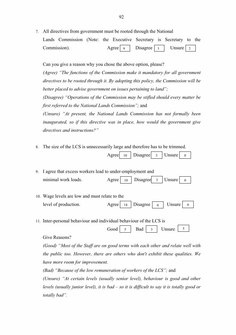
92
7. All directives from government must be rooted through the National
Lands Commission (Note: the Executive Secretary is Secretary to the
Commission). Agree Disagree Unsure 9 3 2
Can you give a reason why you chose the above option, please?
(Agree) �The functions of the Commission make it mandatory for all government
directives to be rooted through it. By adopting this policy, the Commission will be
better placed to advise government on issues pertaining to land�;
(Disagree) �Operations of the Commission may be stifled should every matter be
first referred to the National Lands Commission�; and
(Unsure) �At present, the National Lands Commission has not formally been
inaugurated, so if this directive was in place, how would the government give
directives and instructions?�
8. The size of the LCS is unnecessarily large and therefore has to be trimmed.
Agree Disagree Unsure 10 3 0
9. I agree that excess workers lead to under-employment and
minimal work loads. Agree Disagree Unsure 310 0
10. Wage levels are low and must relate to the
level of production. Agree Disagree Unsure 14 0 0
11. Inter-personal behaviour and individual behaviour of the LCS is
5 Good Bad Unsure 5 3
Give Reasons?
(Good) �Most of the Staff are on good terms with each other and relate well with
the public too. However, there are others who don't exhibit these qualities. We
have more room for improvement.
(Bad) �Because of the low remuneration of workers of the LCS�; and
(Unsure) �At certain levels (usually senior level), behaviour is good and other
levels (usually junior level), it is bad � so it is difficult to say it is totally good or
totally bad�.
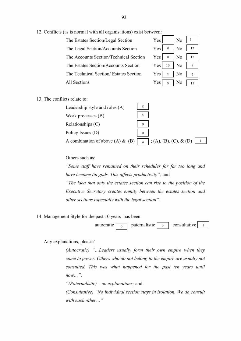
93
12. Conflicts (as is normal with all organisations) exist between:
The Estates Section/Legal Section Yes No 12 1
The Legal Section/Accounts Section Yes No 0 12
The Accounts Section/Technical Section Yes No 0 12
The Estates Section/Accounts Section Yes No 10 3
The Technical Section/ Estates Section Yes No 5 7
All Sections Yes No 0 11
13. The conflicts relate to:
Leadership style and roles (A) 5
3Work processes (B)
0Relationships (C)
0Policy Issues (D)
1A combination of above (A) & (B) ; (A), (B), (C), & (D) 4
Others such as:
�Some staff have remained on their schedules for far too long and
have become tin gods. This affects productivity�; and
�The idea that only the estates section can rise to the position of the
Executive Secretary creates enmity between the estates section and
other sections especially with the legal section�.
14. Management Style for the past 10 years has been:
autocratic paternalistic consultative 129
Any explanations, please?
(Autocratic) ��Leaders usually form their own empire when they
come to power. Others who do not belong to the empire are usually not
consulted. This was what happened for the past ten years until
now��;
�(Paternalistic) � no explanations; and
(Consultative) �No individual section stays in isolation. We do consult
with each other��
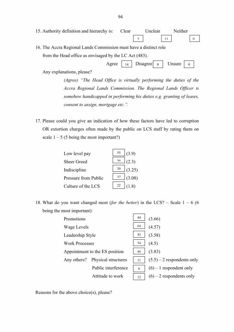
94
15. Authority definition and hierarchy is: Clear Unclear Neither
3 11 0
16. The Accra Regional Lands Commission must have a distinct role
from the Head office as envisaged by the LC Act (483).
Agree Disagree Unsure 14 0 0
Any explanations, please?
(Agree) �The Head Office is virtually performing the duties of the
Accra Regional Lands Commission. The Regional Lands Officer is
somehow handicapped in performing his duties e.g. granting of leases,
consent to assign, mortgage etc.�.
17. Please could you give an indication of how these factors have led to corruption
OR extortion charges often made by the public on LCS staff by rating them on
scale 1 � 5 (5 being the most important?)
Low level pay (3.9) 55
Sheer Greed (2.3) 30
Indiscipline (3.25) 39
Pressure from Public (3.08) 37
Culture of the LCS (1.8) 22
18. What do you want changed most (for the better) in the LCS? � Scale 1 � 6 (6
being the most important):
Promotions (3.66) 44
Wage Levels (4.57) 64
Leadership Style (3.58) 43
Work Processes (4.5) 54
Appointment to the ES position (3.83) 46
Any others? Physical structures (5.5) � 2 respondents only 11
Public interference (6) � 1 respondent only 6
Attitude to work (6) � 2 respondents only 12
Reasons for the above choice(s), please?
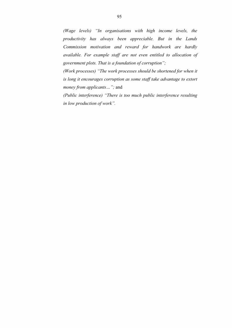
95
(Wage levels) �In organisations with high income levels, the
productivity has always been appreciable. But in the Lands
Commission motivation and reward for handwork are hardly
available. For example staff are not even entitled to allocation of
government plots. That is a foundation of corruption�;
(Work processes) �The work processes should be shortened for when it
is long it encourages corruption as some staff take advantage to extort
money from applicants��; and
(Public interference) �There is too much public interference resulting
in low production of work�.
96
Appendix 3: Questionnaires for Key Decision-Makers and Technical Staff
Part Two � Application Issues
Goal: �introducing a GIS that will support land management applications leading
within five years to increased revenue base, efficiency and timely processes and high
customer confidence in the Accra LCS work processes�
Interpretation: The questionnaire below indicates the frequencies of the responses to
the closed questions in the appropriate response boxes. Some reasons and
explanations given to open questions are edited and quoted to give meaning to some
of the answers given. Interpretation of questionnaire responses is as follows:
Questions Meaning
1 - 14, 16, 18, 19 This relates to mainly �agree� and �disagree� responses
with occasional �not sure� responses as well. Others are
�often�/�sometimes/never� responses aimed basically at
determining training needs. The frequency of the
responses is shown for each question. Where the total of
responses is less than 15, it means some responses were
not given.
17, 20 � 23 These are responses other than �yes� and �no� or �agree�
or �disagree� aimed mainly at seeking confirmation of
facts on the ground.
15 The values in the boxes are aggregated total scores and
values in parenthesis represent derived means. For
example, 14 persons scored a total aggregated score of
120 for �searches� in question 15 with a derived mean of
8.57.
97
1. Have you used computers in your work before?
Often Sometimes Never 4 8 2
2. What software have you used before? Often Sometimes Never
Spreadsheets e.g. Excel 2 3
5
6
Database Management System e. g. Dbase IV, Access 0 7
8 5 1 Word Processing e. g. Word Perfect, Word
7 1 4 GIS (vector) e.g. Arc/Info, ArcView, MapInfo
0 2 9 GIS (raster) e. g. Ilwis, Idrisi
3. Have you heard about Knowledge Based Systems or
13 Decision Support Systems? Yes No 1
4. What about Geographic Information Systems (GIS)? Yes No 14 1
5. Do you have any training in GIS especially? Yes No 4 11
6. I agree that upon introduction of GIS in the LCS, training is
critical and I am prepared to undergo training.
Agree Disagree Not Sure 15 00
7. Training must be tailored to suit the LCS needs and all
0employees must be computer literate Agree Disagree Not Sure 13 2
Any reasons for your choice, please?
(Agree) �GIS can only operate in an environment where all employees
are computer literate, among other factors. This is so because there
can be no GIS without computers and people must be trained to man
the computers� and
(Disagree) �Not all employees (of the LCS) are trainable�.
8. The filing system in the LCS in poor and has to be improved:
Agree Disagree Not Sure 03 12
09. The issue of misplaced files is common Agree Disagree Not Sure 015
98
Any reasons you may want to assign, please?
(Agree) �There is no effective central monitoring unit for dealing with
the movement of files. All officers have files in their offices that cannot
be traced from a central source. Thus a lot of files appear to be
�missing� when in actual fact they are in the system�; and
�Due to the manual handling of files, the volume of work is so much
that sometimes files are misplaced. When records are computerised, it
will make records keeping less cumbersome�.
10. There is generally lack of storage space in the LCS
Agree Disagree Not Sure 13 1 0
11. There is lack of transparency in working procedure
Always Sometimes Never 2130
Any reasons you may want to assign, please?
(Sometimes) �Due to parochial interests�; and
There are sometimes conflicts and power struggles between the
various departments of the LCS and because of this the various
departments are reluctant to be transparent in their (working)
procedures�.
12. Dust is a problem in my work Always Sometimes Never 22 11
13. Unreliable electricity power supply is a major problem Agree Disagree 510
14. Transportation is another major problem to address Agree Disagree 7 6
Any other serious limitations you have observed, please?
�The lack of a proper reception area to limit the loitering around the
offices of staff�;
�The security of documents is not very well taken care of. The public
has access to storage areas that should not be the case�;
��Information is so scattered that it becomes very difficult in getting
the right information�;
�Punctuality and absenteeism�;
99
�Delayed promotions�; and
�No clear cut training for staff�.
15. Of all the type of work done, this is the one I want done by the computer.
(Scale 1 � 9, 9 being the most important)
Presentation (4.3) 56
Searches (8.57) 120
Leases preparation including consents (6.31) 82
Stool lands processing and concurrence (5.67) 68
Family/Private lands processing (4.67) 56
Statutory Declarations (4.67) 56
Rent assessment and Collection (7.43) 104
Site plans (5.5) 66
Plotting (6.77) 88
Registration (3.7) 37
16. I agree that information/data on the LCS must be seen as a corporate
resource (LCS must share data with other agencies)
Yes No Not Necessary 0 015
17. Such Information/Data given to other agencies must be:
Subsidised At Market Value Free 34 8
Any reasons, please?
(Subsidised) �This will ensure effective collaboration and co-
operation with other agencies and also promote efficient land
administration�;
(At market value) ��To recoup the resources invested in the
collection and storing of information and to ensure financial
self sufficiency�;
��Other agencies will always ensure that they come for data
that they actually need�; and
(Free) �Information should be freely made available without
any hindrances whatsoever�.
100
18. Do you want to see the private sector getting directly involved
with our work e.g. being responsible for rent collection for the
LCS? Yes No Sometimes 1 13 1
Any reasons, please?
(Yes) �A lot of rent defaulters. The LCS must engage an agency
to retrieve all rents�;
(No) �The LCS can do the work if given the necessary logistics.
If the funds and logistics given to the Office of the
Administrator of Stool Lands had been given to the LCS to
improve that sector, we could have done the job better�; and
�What is needed is public education. Some lessees� claim that
they are not aware of any obligation in the lease to pay rent
every year, but come to pay when they are told�.
019. GIS must be a unit (department) in the LCS. Yes No 13
Any reasons, please?
(Yes) �So that there can be some permanent staff in the unit to
see to the day to day updating and management of spatial and
attribute data�.
�To give full attention to the data processing and mapping
involved�.
�There is the need to have a central point to co-ordinate the
information�.�.
20. The quality of maps in the records is:
poor fair good very good 3 19 0
Any explanations, please?
(Poor) �Too much handling and poor storage making the plans
deteriorate in time and therefore resulting in loss of vital
information�;
(Fair) �Due to the constant use of the maps for records
information, the wear and tear is high. The LCS does not have
the staff to produce and replace these maps on a periodic
bases�; and
101
(Good) - No explanation given
21. The quality of data (records) is:
Poor fair good very good 00 5 9
Why did you choose any of the options, please?
(Fair) �Most of the maps were produced in the colonial era
and since there has not been any proper updating, this has led
to the deterioration of most of the sheets�; and
(Good) �Even though there are lapses and conflicts in our data
base, to a large extent they can be relied upon�.
22. The reliability on maps in my estimate
is: 80-100% 60-79% 40-59% 20-39% 0-19% 4 4 015
Reasons, please?
(80-100%) �The maps produced are accurate, so once your site
plans are incorrect, the information will most often not be
accurate�;
(60-79%) �This is because some of them are old and have some
parts torn off or mutilated. As such some form of information
may be lacking�;
(40-59%) �Most of them don�t conform to what is on the
ground. They are outmoded and need to be updated or
modified�; and
(20-39%) �Records information cannot be relied on because of
illegal plottings and unreliable plans received from
applicants�.
23. The reliability on data in my estimate is:
Poor fair good very good 0 3 11 0
Any explanations for your choice?
(Fair) �Accessing and retrieval of data is extremely difficult.
Also some site plans annexed to documents are highly
inaccurate, not reflecting the exact situation on the ground�;
and
102
(Good) �Data in our records have been built up over the years
and have been of immense help to the various land agencies,
the private sector and to the public in general. But for lack of
proper storage area which has resulted in the destruction of
some of the data, it could have been very good�.
Any general observations you would like to give?
�For effective land administration to prevail, records
management ought to be given high priority. The data must be
accurate and accessible. That is why I would recommend that
computer training and introduction of GIS will go a long way
to improve upon the work of the Commission�;
�The manual system of working leads to delays and defacing of
papers containing information. There will be the need to train
all category of staff in modern office management, computer
and public relations to enable the staff render quality service to
the public�;
�The Commission should be re-engineered on its works ethics
to enable staff improve upon performance aimed at customer
satisfaction�; and
�For an efficient GIS programme, the Commission must be a
self accounting body with the ability to employ and to sack, and
pay its staff very well to minimise corruption and stealing of
official time for their own private assignments�.
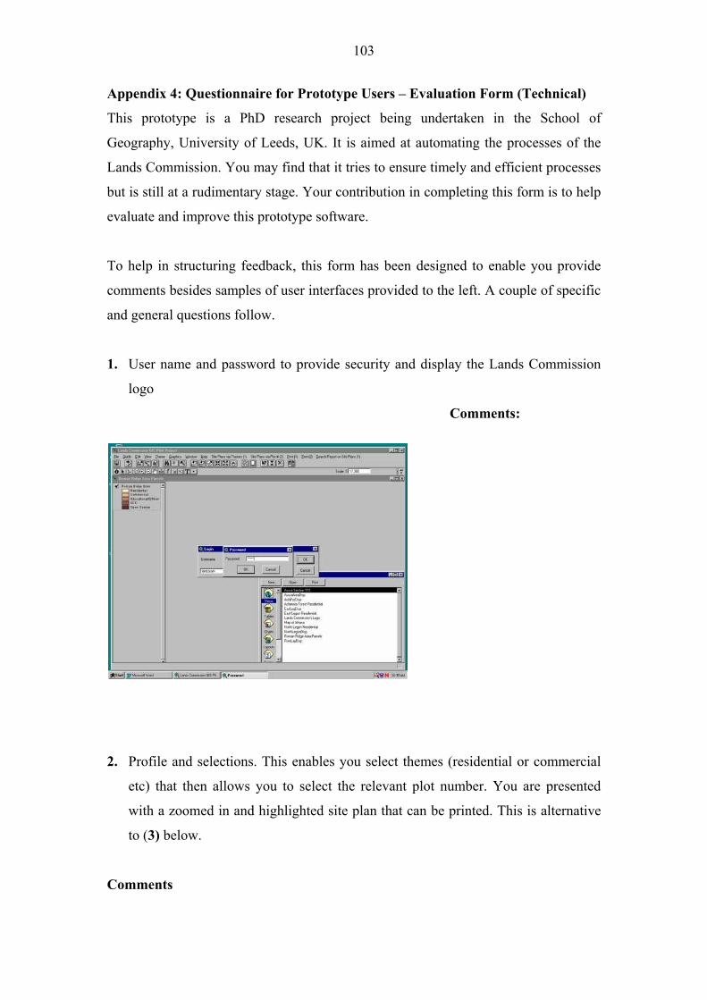
103
Appendix 4: Questionnaire for Prototype Users � Evaluation Form (Technical)
This prototype is a PhD research project being undertaken in the School of
Geography, University of Leeds, UK. It is aimed at automating the processes of the
Lands Commission. You may find that it tries to ensure timely and efficient processes
but is still at a rudimentary stage. Your contribution in completing this form is to help
evaluate and improve this prototype software.
To help in structuring feedback, this form has been designed to enable you provide
comments besides samples of user interfaces provided to the left. A couple of specific
and general questions follow.
1. User name and password to provide security and display the Lands Commission
logo
Comments:
2. Profile and selections. This enables you select themes (residential or commercial
etc) that then allows you to select the relevant plot number. You are presented
with a zoomed in and highlighted site plan that can be printed. This is alternative
to (3) below.
Comments
104
Do you prefer this (2)?
OR this (3)?
3. This allows you to input the plot number yourself and provides some message
boxes for confirmation before site plan is presented just as (2) above.
Comments
105
4. This interface enables the printing of the active site plan
Comments
5. This enables you to select attribute data from a coverage that can be attached to
site plans (2 or 3) as SEARCH REPORT.
Comments
106
6. This enables you to have an instant layout that can be examined
Comments
7. This enables you to print quick maps for Land Technicians to take along for field
inspections (can easily be printed on plotters). You are required to select printer,
preserve scale, provide your own title information on the map, and preview the
map before printing.
Comments
107
8. The Technical officer is allowed by a click of this menu that composes any map
based on available coverages. He is presented with two options ensuring
flexibility: (Layout 1 and Layout 2).
Layout 1 allows him to select any type of north arrow, a neatline, a heading (title
or map), an empty view to select appropriate coverage, an empty scale bar, an
empty legend and a logo of the LCS.
Layout 2 is placed on a template (predefined) and allows him to specify only a
heading.
Comments
9. All ArcView AVENUE scripts are compiled as text files to enable reading. This is
to top technical staff corrupting scripts (placed on the project window script icon).
Comments
108
10. Any of these scripts can be saved as text files and placed in any directory for
printing etc.
Comments
11. Will the application help perform your task better?
12. Will the application help perform your task faster?
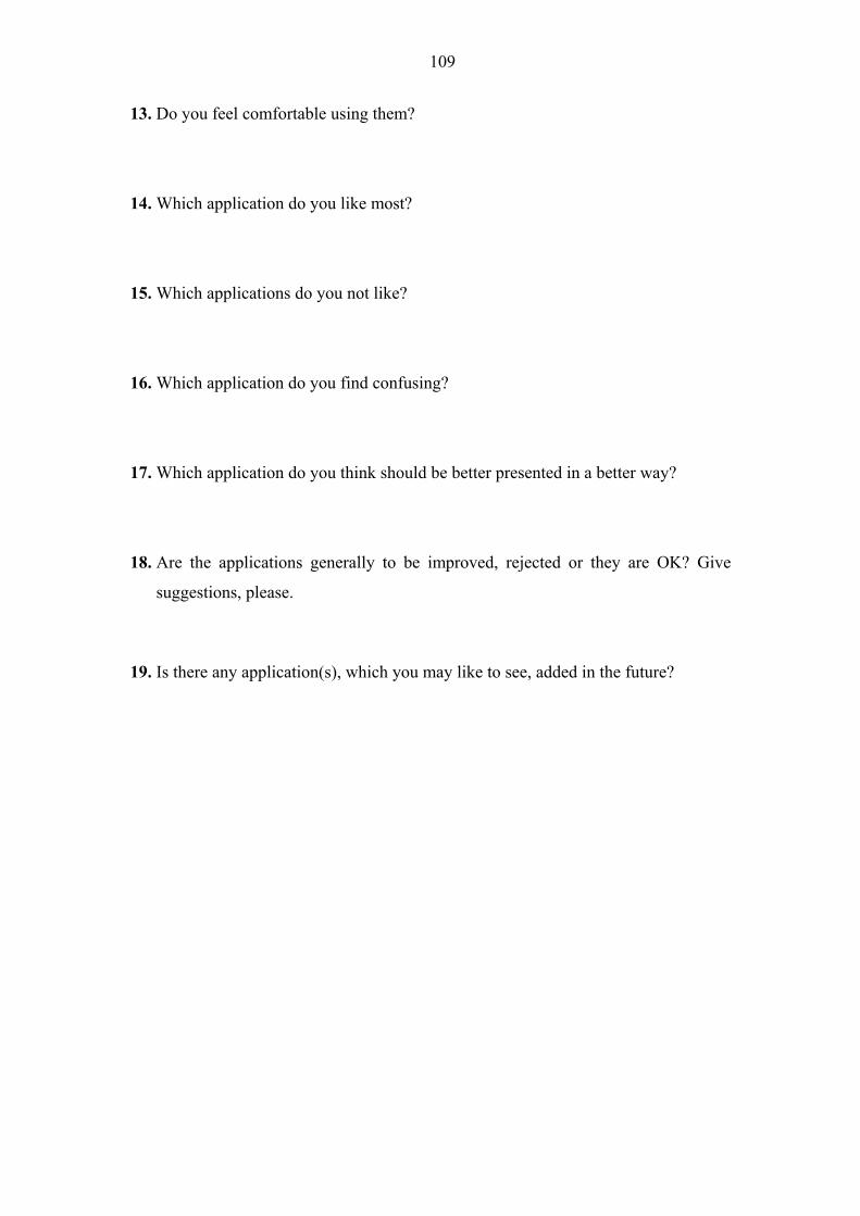
109
13. Do you feel comfortable using them?
14. Which application do you like most?
15. Which applications do you not like?
16. Which application do you find confusing?
17. Which application do you think should be better presented in a better way?
18. Are the applications generally to be improved, rejected or they are OK? Give
suggestions, please.
19. Is there any application(s), which you may like to see, added in the future?
110
Appendix 5: Initial features of the prototype software for testing in the Accra LCS
(September 2001) � ArcView 3.2 Interface
Feature
application
ref. number
Name of feature Function
1. User name and
Password
To provide security and display the LCS logo
2. Selection via
Theme and then
Plot Number (Site
plans)
Selects themes and associated plot number and
presented with zoomed in and highlighted site plan
3. Selection via plot
number only
Selects plot number only and presented with zoomed
in and highlighted site plan (Alternative to 2)
4. Printing of Site
plans
Enables the printing of active site plans
5. Search Report Selects attribute data from a coverage that is to be
attached to site plans as search report
6. Instant Layout Enables layouts to be examined instantly
7. Composition of
quick maps for
inspections
Presented with printer preserve scale, title and preview
dialog and options for quick maps for field inspections
8. Map compositions Composes maps on all available coverages by
selecting the north arrow, a neatline, heading, an
empty scale bar or with scale bar, and empty legend or
with legend and the logo of the LCS on two layouts
presented. Layout 1 allows user manipulation and
layout 2 is predefined and allows input of title only.
9. Avenue scripts as
text files (read
only)
Scripts that run the system are compiled as text files
and can easily be accessed for reading only to prevent
technical staff from corrupting them.
10. Avenue scripts as
text files (placing in
directories)
Alternatively, such scripts can be saved as text files
and placed in any directory.
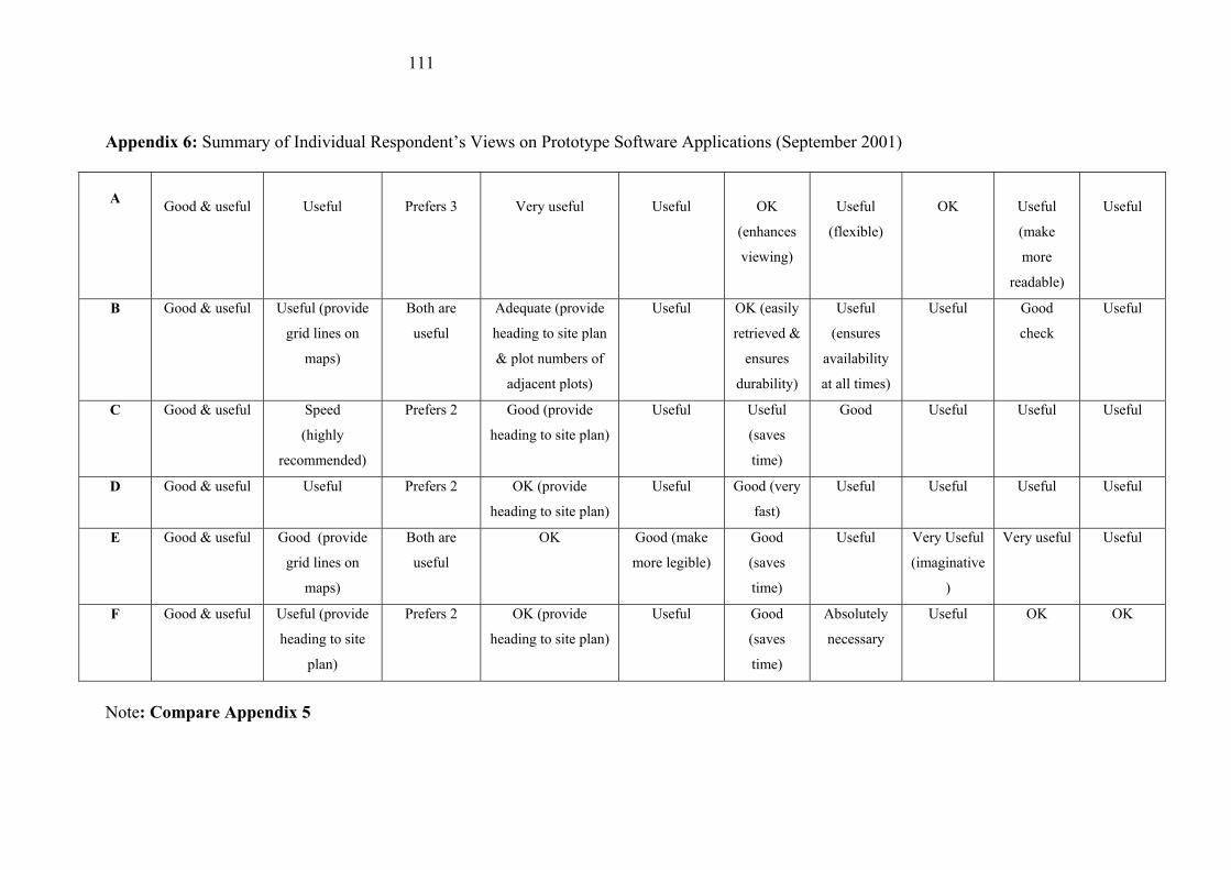
111
Appendix 6: Summary of Individual Respondent�s Views on Prototype Software Applications (September 2001)
A
Good & useful
Useful
Prefers 3
Very useful
Useful
OK
(enhances
viewing)
Useful
(flexible)
OK
Useful
(make
more
readable)
Useful
B Good & useful Useful (provide
grid lines on
maps)
Both are
useful
Adequate (provide
heading to site plan
& plot numbers of
adjacent plots)
Useful OK (easily
retrieved &
ensures
durability)
Useful
(ensures
availability
at all times)
Useful Good
check
Useful
C Good & useful Speed
(highly
recommended)
Prefers 2 Good (provide
heading to site plan)
Useful Useful
(saves
time)
Good
Useful Useful
Useful
D Good & useful Useful Prefers 2 OK (provide
heading to site plan)
Useful Good (very
fast)
Useful Useful Useful
Useful
E Good & useful Good (provide
grid lines on
maps)
Both are
useful
OK Good (make
more legible)
Good
(saves
time)
Useful Very Useful
(imaginative
)
Very useful Useful
F Good & useful Useful (provide
heading to site
plan)
Prefers 2 OK (provide
heading to site plan)
Useful Good
(saves
time)
Absolutely
necessary
Useful OK OK
Note: Compare Appendix 5