Embed Size (px)
Citation preview

GGIISS -- BBaasseedd DDeecciissiioonn aanndd OOuuttrreeaacchh TToooollss
ffoorr AAggggrreeggaattee SSoouurrccee MMaannaaggeemmeenntt
Sponsored by Iowa Highway Research Board IHRB Project TR-571 September 2008 Iowa DNR - Geological Survey

Disclaimer The contents of this report reflect the views of the authors, who are responsible for the facts and the accuracy of the information presented herein. The opinions, findings, and conclusions expressed in this publication are those of the authors and not necessarily those of the sponsors.
The sponsors assume no liability for the contents or use of the information contained in this document. This report does not constitute a standard, specification, or regulation. The sponsors do not endorse products or manufacturers. Trademarks or manufacturers' names appear in this report only because they are considered essential to the objectives of the document. Statement of Non-Discrimination Federal and state laws prohibit employment and/or public accommodation discrimination on the basis of age, color, creed, disability, gender identity, national origin, pregnancy, race, religion, sex, sexual orientation or veteran’s status. If you believe you have been discriminated against, please contact the Iowa Civil Rights Commission at 800-457-4416 or Iowa Department of Transportation's affirmative action officer. If you need accommodations because of a disability to access the Iowa Department of Transportation’s services, contact the agency's affirmative action officer at 800-262-0003.
I
I
Technical Report Documentation Page
1. Report No.
IHRB TR-571
2. Government Accession No.
4. Title and Subtitle
GIS - Based Decision and Outreach Tools
for Aggregate Source Management
7. Author(s)
Robert D. Libra, Chris Kahle
9. Performing Organization Name and Address
Iowa DNR - Geological Survey
109 Trowbridge Hall
Iowa City, IA 52242
12. Sponsoring Organization Name and Address
Iowa Highway Research Board
Iowa Department of Transportation
800 Lincoln Way
Ames, IA 50010
17. Key Words
aggregate sources, quarries, materials, gravel, sand, crushed stone
22. Price 21. No of Pages 19. Security Classification (of this page) Unclassified
19. Security Classification (of this report) Unclassified
18. Distribution Statement
16. Abstract
This research project combined various datasets, existing and created for this project, into an Interactive
Mapping Service (IMS) for use by Iowa DOT personnel, county planning and zoning departments and the
public in order to make more informed decisions regarding aggregate sources and future access to them.
Iowa DOT Technical Advisory Committee meetings were held, along with public forum presentations, in
order to understand better the social, ecological and economic limitations to extracting aggregate. The
information needed by potential users was conveyed and integrated into a single informational source, the
Aggregate Planning IMS.
15. Supplementary Notes
Visit http://www.iowadnr.gov/mapping/index.html for this and other IDNR IMS sites
14. Sponsoring Agency Code
13. Type of Report and Period Covered
Final Report
11. Contractor or Grant No.
10. Work Unit No. (TRAIS)
8. Performing Organization Report No.
6. Performing Organization Code
5. Report Date
September 2008
3. Recipient’s Catalog No.
III

GIS - Based Decision and Outreach Tools for Aggregate Source Management
Sponsored by the Iowa Highway Research Board IHRB Project TR-571
Principal Investigators
Robert D. Libra – State Geologist Iowa Department of Natural Resources - Geological Survey
Chris Kahle – GIS Analyst
Iowa Department of Natural Resources - Geological Survey
Authors
Robert D. Libra – State Geologist Iowa Department of Natural Resources - Geological Survey
Chris Kahle – GIS Analyst
Iowa Department of Natural Resources - Geological Survey
Iowa Geological Survey 109 Trowbridge Hall Iowa City, IA 52242 Phone:319-335-1575 FAX:319-335-2754
http://www.igsb.uiowa.edu/
Final Report September 2008
IV

Table of Contents 1. Introduction……………………………………………………………………1 2. Concept Design….……………………………………………………………..2 3. Outreach Efforts and Application Design………..…………………………….4 4. Implementation/Technology Transfer…………………………………...…….7 5. Iowa DOT and Other Support……………………………………………..…..7 6. Benefits………………………………………………………………...………7 7. Future Efforts…………………………………………………….…………….8 8. References……………………………………….……………………...……...9
List of Figures 1. Figure 1. Development around existing quarries …….………………...……...1 2. Figure 2. Depth to Bedrock in Iowa…………… …….………………...……..4 3. Figure 3. Limiting factors to aggregate extraction…….………………...……..8
List of Tables 1. Table 1. Jager Himms, constraints to aggregate extraction……………...……..3
V

Introduction Rural and suburban residents have become increasingly resistant to the establishment or expansion of quarries and sand pits in their vicinity. This has increased haul distances for road projects, which in combination with rapidly rising fuel prices has increased costs for aggregate at the job site. Land use conflicts have also raised concerns over adequate supplies of certified high-quality aggregate required for certain state and federal projects. As zoning decisions affecting aggregate operations are typically made by county zoning programs and boards of supervisors, readily useable and useful mapping tools are needed to show current and potential sources in relation to adjacent land use, natural and cultural resources, and development trends in their locales. Such mapping tools represent a first step towards establishing local and state-wide plans for assuring aggregate availability. Figure 1. Development occurring around Crawford and Morgan Creek quarries in Linn County outside of the western city limits of Cedar Rapids, IA
1

Concept Design Land use conflicts involving aggregate mining have increased over the past decades as suburban and rural housing developments have grown around the outskirts of many cities and towns. While this issue first arose around the nations larger metropolitan areas, they are becoming more numerous in Iowa as well. Such conflicts are likely to continue, as both demand for aggregate and suburban - “sub-rural” populations grow. For example, the U.S. Geological Survey estimates suggests that nationally, the amount of crushed stone to be produced in the next 20 years will equal the quantity of all stone produced during this century (Langerand and Glanzman, 1993). In response, many states, Canadian Provinces, and local governments have began efforts to incorporate “planning for aggregate” in there long-term land-use plans and zoning decisions. These efforts are commonly state-wide guides for planning (Virginia Division of Mineral Resources, 2003); (Oregon Department of Land Conservation and Development and Oregon Department of Transportation, 2001); (Minnesota Aggregate Resources Task Force, 1998); (Lingely and Jazdzewski, 1994); (Bobrowsky et. al, 1996); (Beeby, 1998). Others focus more on plans or strategies for regional areas such as the Twin Cities metro area (Southwick et. al, 2000), the New York metro area (Hedec, 1969), New England (New England Governors’ Conference, 1995) and the Denver/Front Range area (Nassar, 1987). Others are more localized and contain recommended and established zoning code language defining areas and practices for aggregate mining (Jagger Hims Limited et. al, 2004); (Aggregate Resources Mining Roundtable, 1987); (county citations in: Virginia Division of Mineral Resources, 2003). State-level efforts are typically planning guides for local government entities which exercise zoning authority. Needed information for the first steps in planning for future aggregate access in these studies and guides focus on: 1.) locations and descriptions of the aggregate resource; and 2.) factors with implications for extraction. For example, Jagger Hims Limited et. al (2004), in an aggregate plan for Grey County, Ontario, produced maps of aggregate source areas and classified source areas into categories based on the quality and economic accessibility of the resource. They further broke these areas into five categories based on barriers to mining. These categories include: Eliminated Lands, Highly, Moderately, or Minimally Constrained Lands, and Unconstrained Lands. Eliminated lands included resource areas with sufficient natural, infrastructure, societal, or other barriers to mining that they were considered unmineable for the foreseeable future. Unconstrained lands faced virtually no such barriers, while the remaining categories describe areas intermediate between these end members. Examples of criteria for this evaluation are given in the table below:
2

Table 1. Jagger Hims Limited et. al (2004), Table 14-1, page 44. In a similar manner, Southwick et al. (2000) mapped aggregate resources for “unencumbered” lands in the Twin Cities area. Unencumbered lands included undeveloped areas, but excluded environmentally sensitive areas such as streams, wetlands over five acres, and scientific and natural areas. Buffer zones where established around these areas. Areas where development was considered inevitable were also included in their classification. Statewide guidelines are less specific, as they aren’t designed to address all possible local conditions, but they echo the same themes. Virginia’s suggests:
Prior to decision-making, data should be compiled on the size and quality of each potential deposit; transportation and proximity to future areas of demand; nature of competing land uses; potential impact on the environment from extraction activities (including the effect on ground and surface water, the impact of extraction operations on the landscape, and the potential for satisfactory land restoration and land use subsequent to restoration); and compatibility with surrounding land uses (Virginia Division of Mineral Resources, 2003).
We drew on the approaches used in other aggregate planning efforts, particularly those related to creating useful statewide mapping tools for use by IDOT and local entities, with a focus on the most basic first-steps: 1.) Locations and descriptions of the aggregate resource 2.) Factors with implications for extraction.
3

A more complete view of the resource was obtained by combining mine coverages with bedrock and surficial geologic map coverages of the state, allowing for better extrapolation of potential resource locations and defining relationships between aggregate quality and geologic map units to the degree possible. A depth to rock coverage was used to identify areas where rock aggregate sources are relatively shallow and have the potential to be economically mined. In addition we worked in consultation with county planning and zoning officials (Iowa State Association of Counties-County Zoning Affiliate (ISAC)), IDOT Office of Materials Staff, and the aggregate industry (Iowa Limestone Producers Association (ILPA)) to develop tools that best address the aggregate resource, and the natural, infrastructure, societal, or other barriers to aggregate access. Outreach Efforts and Application Design An initial “bare-bones” version of the Aggregate Planning IMS was made web-available in the summer of 2007, to make potential users aware of the concept and to generate feedback regarding the types of information and functionality to include. In addition a variety of presentations and outreach efforts were utilized to further assess user needs. These included:
• Several presentations to ILPA and ISAC county zoning officers. • Several presentations and meetings with DOT staff • A joint session with ILPA, ISAC, IDOT, and IGS representatives. This meeting
was particularly valuable in drawing together interested parties. Figure 2. Depth to bedrock in Iowa, broken down in meaningful groupings for aggregate producers as expressed in outreach meetings (yellow is less than 50ft to bedrock, light pink is 50 to 100ft to bedrock, dark pink 100 to 200ft to bedrock and brown greater than 200ft to bedrock).
4

These sessions reviewed the coverages that were available in the Natural Resources GIS Library (http://www.igsb.uiowa.edu/nrgislibx/), as well as useful coverages that could be created in the time frame and scope of the project. Those viewed by users as the most useful for aggregate protection planning, and those viewed as representing significant impediments to or positives for resource extraction, were combined with those describing the resource itself and added as layers into an Internet Map Service (IMS) application. Feedback from meetings and outreach efforts resulted in the following GIS coverages being included (groupings in bold): Administrative and Political Boundaries County boundaries Town boundaries Conservation and Recreational Lands Aggregate Source Mines IDOT (T203) – broken down by bed and revetment characteristics Mines IDALS Mineral Industry Locations Systems (MILS) Alluvium
Depth, in feet, to bedrock (<50, 50-100, 100-200 and greater than 200) Bedrock Geology GOESAM Sites (Geologic sampling points from IGS) Air Photography 2005 NAIP 2002 CIR Elevation 1:24K Topographic Maps Hillshade Percent Slope Elevation Environmental Regulation) Wastewater Treatment Plants Geographic Township Section Geodetic Control Points County GPS Monuments (for counties that have made data available) Hydrologic Watershed: 12 Digit HUCs Streams Lakes
5

Infrastructure Roads Highways Interstates Iowa DOT Road Map (Grid file)
Major Pipelines Major Powerlines Railroads
Cultural Cemeteries Archeological Sites (from the Office of the State Archaeologist) Eco Sensitive Sites (from DNR - Natural Areas Inventory) Census Growth in Housing (1990 – 2000) Land Description Landcover 2002 Landcover 2000 Landcover 1992 Midwest Midwest Towns Midwest Lakes Midwest States Soils Soils maps (SSURGO with ISPAID) Soil Loss (T/A/Y) Hydric Soils Erodibility Corn Suitability Rating
6

Implementation/Technology Transfer The final product of this work will be delivered in two mediums for two specific audiences. The first product will be the shapefiles created of historical and current quarry operations for the State, with data linked as specified by Iowa DOT for Iowa DOT staff use. The second product will be the Internet Map Service (IMS) created for use by Iowa DOT, planning groups and the public. The public version of the Aggregate Planning IMS currently resides on the Iowa DNR website at http://programs.iowadnr.gov/ims/website/aggregate_planning/viewer.htm Iowa DOT staff, planning groups and the public will be using the data resulting from this project. Iowa DOT will use shapefiles and IMS while planning groups and the public will use the IMS for aggregate source questions. This data will be used in planning future aggregate source access by making the data available prior to planning and development of residential/business subdivisions. Iowa DOT and Other Support Assistance required by Iowa DOT staff included the provision of the latest T203 document in digital (DBF) format for use in creating coverage of current Iowa DOT aggregate sources. Also provided was all information that Iowa DOT staff would like to link to these datasets for either internal or external use. Some additional time from DOT-Office of Materials staff was required during the initial design and testing of the IMS that was developed for use by DOT staff and local planners. Discussions with Materials and IRHB staff indicated that the level of involvement doesn’t require formal approval. ILPA, ISAC, the Office of the State Archaeologist, the Department of Agriculture and Land Stewardship, and a variety of Iowa DNR program areas also provided support. Benefits Potential benefits from this project include cost savings for transportation of aggregate materials in DOT, county, or city construction projects by providing a spatial tool that allows DOT staff to readily assess the closest/best sources of material for projects. Another benefit will be the potential for protection of known aggregate sources needed for future road projects, an essential step in planning for future aggregate needs. Other cost savings will be related to ease of access to aggregates, or elimination of restrictions to access, by having the aggregate issues available for planners prior to the planning process. This is also an improvement in procedure, making this information accessible to planners and other interested parties may avoid constraints involving access to an aggregate source in the future.
7
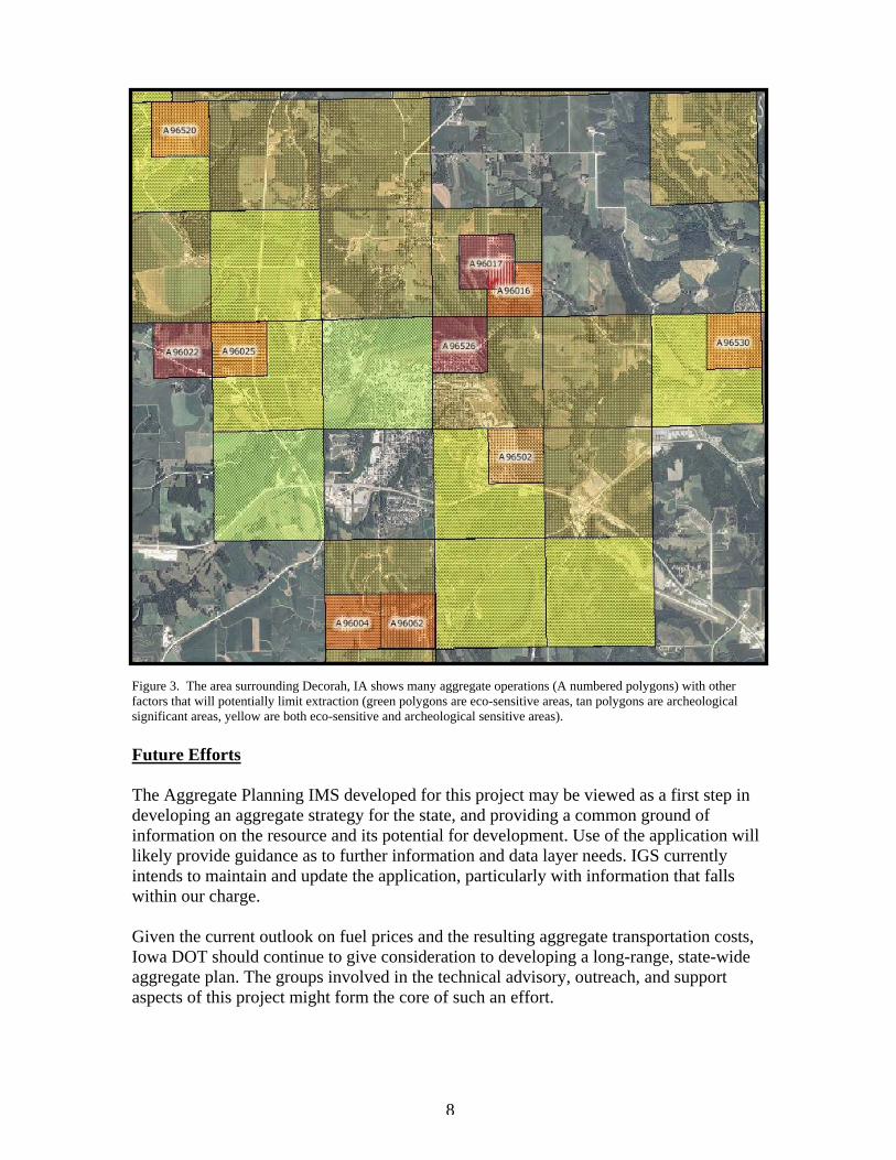
Figure 3. The area surrounding Decorah, IA shows many aggregate operations (A numbered polygons) with other factors that will potentially limit extraction (green polygons are eco-sensitive areas, tan polygons are archeological significant areas, yellow are both eco-sensitive and archeological sensitive areas). Future Efforts The Aggregate Planning IMS developed for this project may be viewed as a first step in developing an aggregate strategy for the state, and providing a common ground of information on the resource and its potential for development. Use of the application will likely provide guidance as to further information and data layer needs. IGS currently intends to maintain and update the application, particularly with information that falls within our charge. Given the current outlook on fuel prices and the resulting aggregate transportation costs, Iowa DOT should continue to give consideration to developing a long-range, state-wide aggregate plan. The groups involved in the technical advisory, outreach, and support aspects of this project might form the core of such an effort.
8

References Aggregate Resources Mining Roundtable, 1987, “Report of the Jefferson County, Colorado Aggregate Resources Mining Roundtable”, 38 p. Beeby, D.J. 1998. Successful integration of aggregate data in land-use planning: a California case study. In: Aggregate resources: a global perspective (P.T. Bobrowsky, ed.), pp. 113-129. A.A. Balkema, Rotterdam. 470 pp. Bobrowsky, P.T., Massey, N.W.D. and Matysek, P.F., 1996, Aggregate Forum: Developing an Inventory that Works for You! Report of Proceedings: B.C. Ministry of Energy, Mines and Petroleum Resources, Information Circular 1996-6. Hudec, P.P., 1969, Long range planning for aggregate materials in metropolitan New York, in Hoover, K. V., ed., Fifth Forum on the Geology of Industrial Minerals: Pennsylvania Bureau of Topographic and Geologic Survey Mineral Resources Report M64, p. 165-177. Jagger Hims Limited, Skelton Brumwell & Associates Inc, ESG International, and C.N. Watson Limited, 2004, “Aggregate Resource Inventory Master Plan, Grey County, Ontario”, 305 p.
Langer, W.H., and Glanzman, V.M., 1993, “Natural aggregate—Building America's future.” U.S. Geological Survey Circular 1110, 39 p.
Lingley, W.S., Jr., and Jazdzewski, S.P., 1994, Aspects of growth management planning for mineral resource lands: Washington State Department of Natural Resources, Washington Geology, v. 22, no. 2, p. 36-45. Minnesota Aggregate Resources Task Force, 1998, “Minnesota’s Aggregate Resources: Road to the 21st Century”, 38 p. Nasser, K., 1987, “Supply/Demand Analysis of Aggregates in the Denver Metro Area”, Jefferson County, Colorado Planning & Zoning Department, 49 p. New England Governors’ Conference, 1995, Construction aggregate resources of New England – An analysis of supply and demand: New England Governors’ Conference, Inc., Boston, 10 sections, variously paged. Oregon Department of Land Conservation and Development and Oregon Department of Transportation, 2001, “Planning for Aggregate: A Guide to Planning for Aggregate Resources in Oregon”, 64 p. Virginia Division of Mineral Resources, 2003, “Incorporating Mineral Resources into the Planning Process”, Virginia Division of Mineral Resources, http://www.mme.state.va.us/Dmr/DOCS/Plan/plan2.html
9