Embed Size (px)
Citation preview

Huda Al-MunayesEnvironment Public AuthorityInformation System [email protected] : 965 – 4818028Fax : 965 - 4820579
Early Warning Case Study forAl-Qurain Landfill Area Fires
in KuwaitThrough Using Geographic
InformationSystem Technology
GIS bring us together
Disaster Relief and ManagementAlexandria (Egypt), 14-17 April 2007 2007

Types of Maps
Internet Map
Mind Map
Brain Map
Heart Map
Disaster Relief and ManagementAlexandria (Egypt), 14-17 April 2007

• The State of Kuwait occupythe Northeastern part ofArabian Peninsula Boundedon the north & west by Iraq &on the west & south bySaudi Arabia
• It has approximately500km of coast line
• Has surface area of ~ 18,000Km²
• Total population of Kuwait ~2.5 million in 2003, where theKuwaiti nationality is ~1million Disaster Relief and Management
Alexandria (Egypt), 14-17 April 2007
But we are using another kind of Maps ….Computerize maps
During the 1970's with theabsence of regulations andlegislations to organizethe dumping of domesticwaste, Kuwait Municipalitywas Casting quantities ofmunicipal and constructionwastes without planning.
The Establishment of EnvironmentPublic Authority has big rule in
stopping the old and primitive ways tomanage the waste, and substituted
with new Criteria and scientificsystems for protecting theenvironment & eliminate the
damage from the existing landfills .
Community Complains …
The Problem
Citizens are theaffected Party

Where is the Landfill?
Located 15 kmsouth
of Kuwait city
one square kmWhat size ?
Disaster Relief and ManagementAlexandria (Egypt), 14-17 April 2007
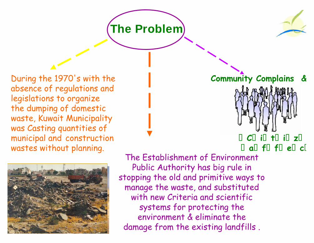
Occupiedapprox1km²
Waste varies inDepth from 6mOn the edge to
24 m in thecenter
Contains ~ 5million
Cubic Meters ofsolid waste
Wastes Are PrimarilyDomestic Garbage,
Construction &Industrial
The site wasUtilized As a
sanitary solid wastedisposal site from
1975-1985
Site
Description
Disaster Relief and ManagementAlexandria (Egypt), 14-17 April 2007

Aerial photography ofthe area in 1976
In the Past : It was anOpen area, any one cancast waste in this area .
Aerial photography inThe Beginning of 80’s …
Disaster Relief and ManagementAlexandria (Egypt), 14-17 April 2007
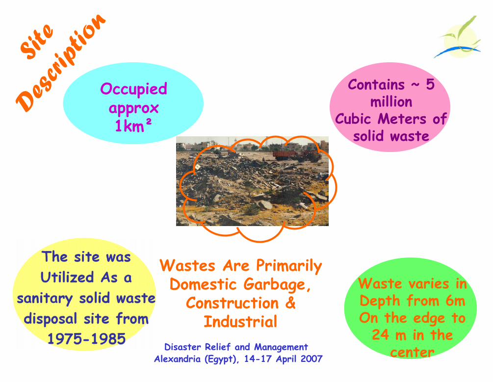
Aerial photography foryear 92
Aerial photography foryear 96

With the fast urban development and expandingof Kuwait society, one of these dumping areasbeen designated as a residential area …..
It considered the Qurain Landfill areaone of its priorities to clean andrehabilitate for the sake of health &safety of the inhabitants.
When Environment Public Authority been established on1996 to carry out all activities and functions to ensure theprotection of the environment in the state ,,
Disaster Relief and ManagementAlexandria (Egypt), 14-17 April 2007
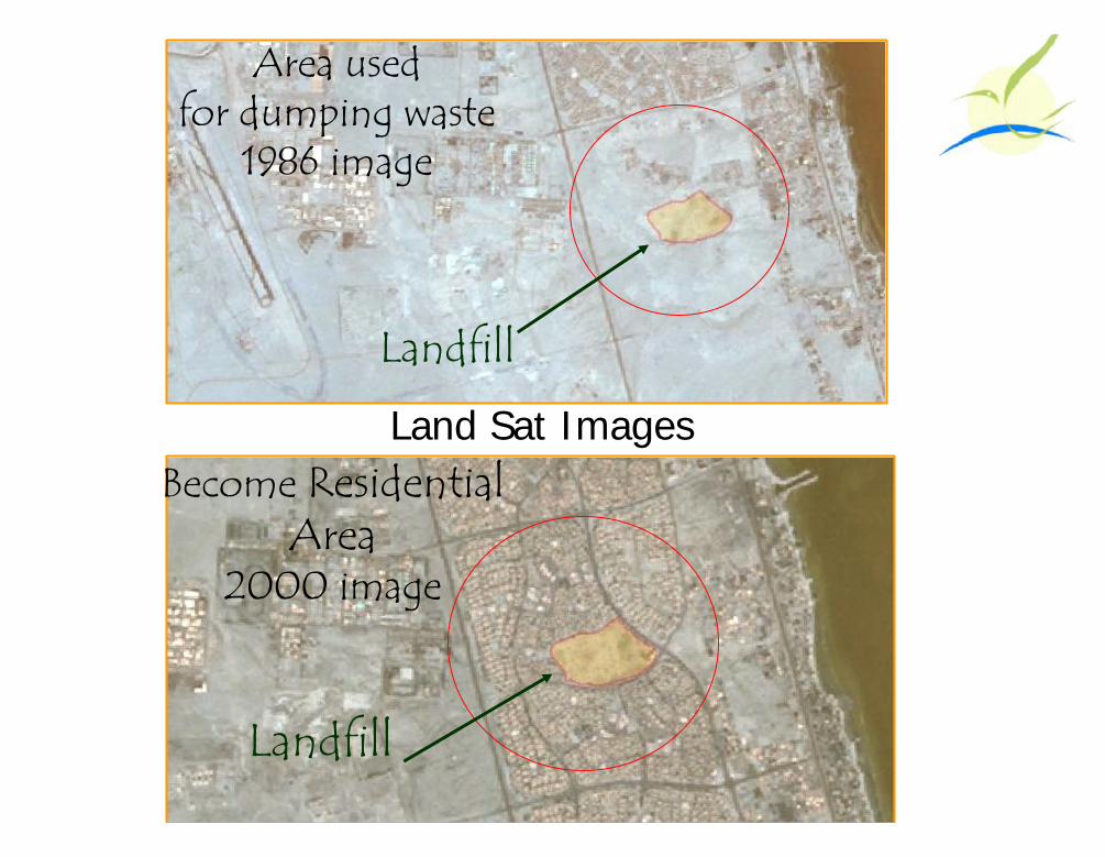
Land Sat Images
Area usedfor dumping waste
1986 image
Become ResidentialArea
2000 image
Landfill
Landfill

Main Objectives
Build up a complete Spatial database for theLandfill area .
• Create hazard zones mapsthat integrate different data layersWith population information.
Disaster Relief and ManagementAlexandria (Egypt), 14-17 April 2007
Also, to present the information ina way that a non-technical staff
can understand

BiodegradationOf organicMatter &bad odorsreleases
Huge pressurefrom generatedgases mainlyMethane CH4
which canlead to
Fire hazards
Pollution toair ,
Water&
land
Qurain Community under Thread ….
The dumping area is major health & safetythreat to the community, and to Environment
Due to :
NoteSince it’s an ignored site with piles of waste without anycontrol, the area become suitable for illegal activities

When Fire Occurs
Usually a fire incident can occur when children playingin the landfill site throwing some matches on thesecracks for fun.
In case of fire breaks out, EPA will contact thefire department who is already familiar with this case asEPA meets on a regular basis and discuss these matterswith the fire department.
Disaster Relief and ManagementAlexandria (Egypt), 14-17 April 2007
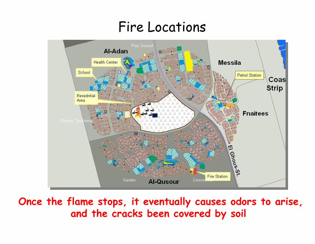
Once the flame stops, it eventually causes odors to arise,and the cracks been covered by soil
Fire Locations

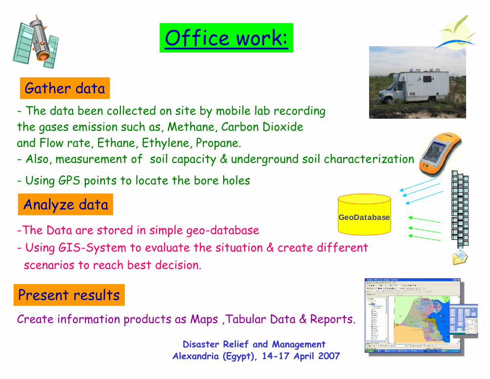
The project been implemented in 2 directions;Field work & Office work
Disaster Relief and ManagementAlexandria (Egypt), 14-17 April 2007
Field workEPA action plan – Rehabilitation :
1- Removing the surface waste
2- Drill ~ 300 wells (boreholes) inAl-Qurain area & near the residential houses
3- Accumulate the gases by network system.
4- Establishing the complete gas network to use theflow of gases in producing electricity by the generator system
Present results
Office work:
Disaster Relief and ManagementAlexandria (Egypt), 14-17 April 2007
Gather data
Analyze data- Using GPS points to locate the bore holes
-The Data are stored in simple geo-database- Using GIS-System to evaluate the situation & create different
scenarios to reach best decision.
Create information products as Maps ,Tabular Data & Reports.
GeoDatabase
- The data been collected on site by mobile lab recordingthe gases emission such as, Methane, Carbon Dioxideand Flow rate, Ethane, Ethylene, Propane.- Also, measurement of soil capacity & underground soil characterization
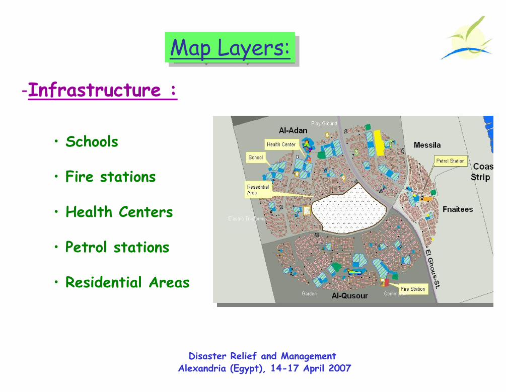
Map Layers:Map Layers:
-Infrastructure :
• Schools
• Fire stations
• Health Centers
• Petrol stations
• Residential Areas
Disaster Relief and ManagementAlexandria (Egypt), 14-17 April 2007
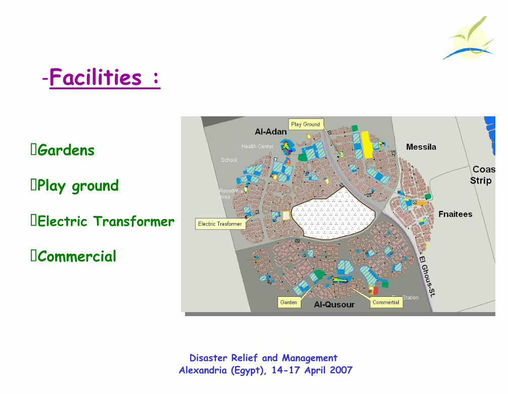
-Facilities :
Disaster Relief and ManagementAlexandria (Egypt), 14-17 April 2007
• Gardens
• Play ground
• Electric Transformer
• Commercial

• Boreholes :
- Sand properties
- Solid waste Locations
Demographics :
Disaster Relief and ManagementAlexandria (Egypt), 14-17 April 2007
Solid Waste
ConstructionDebris
No Waste
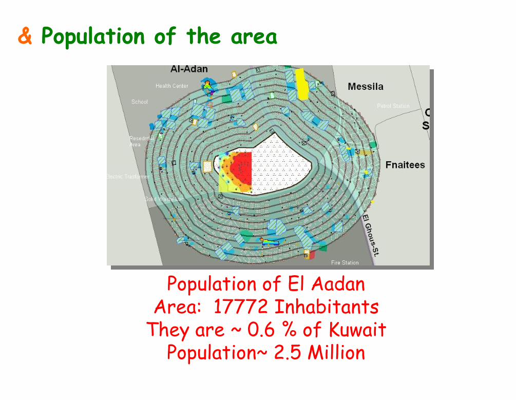
& Population of the area
Population of El AadanArea: 17772 Inhabitants
They are ~ 0.6 % of KuwaitPopulation~ 2.5 Million

Utilizing GIS SystemUtilizing GIS System
Disaster Relief and ManagementAlexandria (Egypt), 14-17 April 2007
We usedWe used GISGIS to serve as a tool for :
Managing the Landfill site, through Visualizingthe Spatial Relationships betweenvarious Features As :- Parcels & buildings around the
dumping area.- Soil Type & soil Bearing Capacity
- Gas distribution & gas migration behavior
- Impact of landfill fires & the bad odors to thesurroundings.
- Using Census Data to evaluate inhabitants whoare potential risk .

Disaster Relief and ManagementAlexandria (Egypt), 14-17 April 2007
ResultsResults

0 – 10.1 % lowest
10.1 – 19.7 % Moderate
19.7 – 32.9 % High
32.9 – 51.82 % Highest
CH4 – Buffer1989
CH4 – Buffer1989
5 Bore Holes been made
Potentially affected Area’s
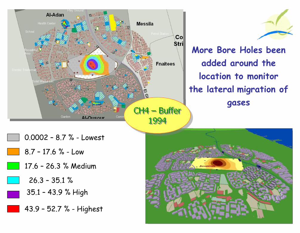
More Bore Holes beenadded around thelocation to monitor
the lateral migration ofgases
0.0002 – 8.7 % - Lowest
8.7 – 17.6 % - Low
17.6 – 26.3 % Medium
26.3 – 35.1 %35.1 – 43.9 % High
43.9 – 52.7 % - Highest
CH4 – Buffer1994
CH4 – Buffer1994

0.0003 – 8.4 % - Lowest8.4 – 16.8 % - Low16.8 – 25.3 % Medium
25.3 – 33.7 %33.7 – 42.2 % High42.2 – 50.6 % - Highest
CH4 – Buffer1997
CH4 – Buffer1997
Result :Result : RedistributionOf gases pressure in
the land fill area
Start removing theupper layer of waste

The Southern west ofLandfill area has beencovered with Layer
of getch
Result :Result : RedistributionOf gases pressure
in the dumping Area& the concentrationdecreases in the
southern west part
CH4 – Buffer2000
CH4 – Buffer2000
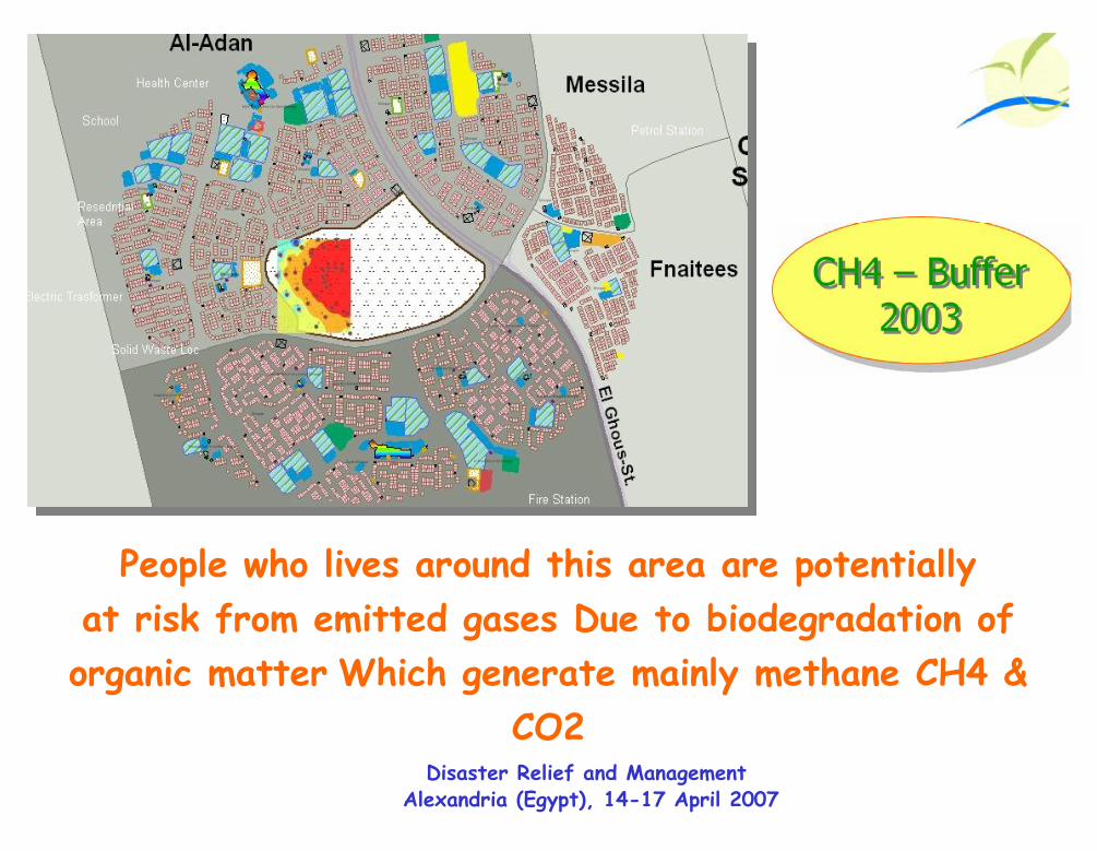
CH4 – Buffer2003
CH4 – Buffer2003
People who lives around this area are potentiallyat risk from emitted gases Due to biodegradation oforganic matter Which generate mainly methane CH4 &
CO2Disaster Relief and Management
Alexandria (Egypt), 14-17 April 2007

Measures of Methane from 1989 - 2000
Fire breaksout
RedistributionOf CH4
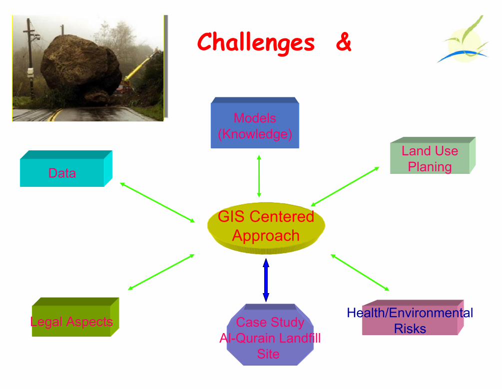
Challenges …
GIS CenteredApproach
Land UsePlaning
Health/EnvironmentalRisksLegal Aspects Case Study
Al-Qurain LandfillSite
Data
Models(Knowledge)

Project Progress
• Continue collecting data from the field
• Capping the landfill area
• Digging more Boreholes
GeneratorGeneratorGenerator
GasesGasesGases• Create an integrated system toAccumulate the gases by
network system into a fire flare
Electricity forSurrounding
houses
Generator is used to supply electricityto the surrounding area
Now, the Flaring areNow, the Flaring arecanceledcanceled

End of bad odors problem&
Become Public Park
Landfill Location After Rehabilitation ….